LAOIS-KILKENNY REINFORCEMENT PROJECT - PHASE 1 LEAD CONSULTANT'S REPORT IDENTIFICATION OF EMERGING PREFERRED SUBSTATION SITE AND EMERGING ...
←
→
Page content transcription
If your browser does not render page correctly, please read the page content below
Laois-Kilkenny
Reinforcement
Project
Phase 1 Lead Consultant’s Report
Identification of Emerging Preferred Substation
Site and emerging preferred Route Corridor

MAY 2011
File Reference:

    Client / Recipient:                     EIRGRID

    Project Title:                          Laois - Kilkenny Reinforcement Project

    Report Title:                           Phase 1 Lead Consultants Report – Identification of
                                            Emerging Preferred Substation and Emerging Preferred
                                            Route Corridor
    Report No.:                             PE687-F0261-R261-007-000

    Rev. No.:                               000

    Volume 1 Of 1

    Prepared By:                            Shane McLoughney

    Title:                                  Overhead Line Planner

    Approved:                               Shane McLoughney

    Title:                                  Overhead Line Planner

    Date:                                   May 2011

    COPYRIGHT © ESB INTERNATIONAL LIMITED
    ALL RIGHTS RESERVED, NO PART OF THIS WORK MAY BE MODIFIED OR REPRODUCED OR COPIES IN ANY FORM OR BY
    ANY MEANS - GRAPHIC, ELECTRONIC OR MECHANICAL, INCLUDING PHOTOCOPYING, RECORDING, TAPING OR INFORMATION
    AND RETRIEVAL SYSTEM, OR USED FOR ANY PURPOSE OTHER THAN ITS DESIGNATED PURPOSE, WITHOUT THE WRITTEN
    PERMISSION OF ESB INTERNATIONAL LIMITED.

2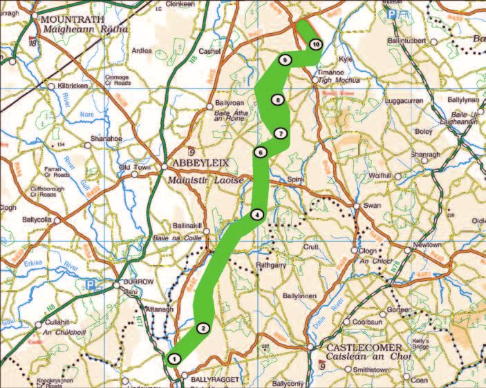
PART A - PROJECT OVERVIEW
1.0       Introduction                                8
1.1       Project Justification                       8
1.1.1     Technical Alternatives Considered           9
1.2       The Purpose of this Report                  10
1.3       About EirGrid                               11
1.4       Strategic Planning Context                  11
1.4.1     National Objectives                         11
1.4.2     Regional Objectives                         12
1.4.3     Local Objectives                            13
1.4.4     GRID25                                      13
1.5       EirGrid Position on Underground Cables      14
1.6       General Project Description                 15
1.7       Typical Structures Description              16
1.7.1     Overhead Line Structures 400 kV             16
1.7.2     Overhead Line Structures 110 kV             18
1.8       Station Descriptions                        19
1.9       Project Roadmap                             21
1.10      Project Team                                23
1.11      Health and Safety                           23

2.0       Study Area and Constraints Identification   24
2.1       Study Area Identification and Description   24
2.2       Identification of Constraints               26
2.3       Constraints Map Production and Summary      26
2.3.1     Man-made Constraints                        27
2.3.1.1   Human Beings                                27
2.3.1.2   Cultural Heritage                           27
2.3.1.3   Existing Infrastructure                     28
2.3.2     Natural Constraints                         28
2.3.2.1   Landscape                                   28
2.3.2.2   Ecology                                     29
2.3.2.3   Soils & Geology                             30
2.3.2.4   Hydrology and Hydrogeology                  30
2.4       Phase 1 Consultation                        30
2.4.1     An Bord Pleanála                            30
2.4.2     Statutory and Non Statutory Consultees      31
2.4.3     Public Consultation                         31
2.4.4     Review                                      31

3.0       Substation Site Identification              32

                                                           3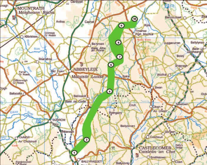
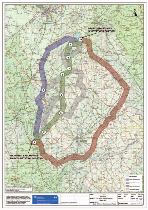
4.0     Route Corridor Identification                              35
    4.1     400kV Route Corridor                                       37
    4.2     Western 110kV Route Corridor                               37
    4.3     Central 110kV Route Corridor                               37
    4.4     Eastern 110kV Route Corridor                               37
    4.5     110kV Sub Route Corridors                                  37
    4.5.1   Node 2 to Node 4                                           37
    4.5.2   Node 3 to Node 7                                           38
    4.5.3   Node 5 to Node 6                                           38
    4.5.4   Node 7 to Node 9                                           38
    4.5.5   Node 9 to Node 10                                          38

            PART B - OVERVIEW OF ENVIRONMENTAL ISSUES
    5.0     Consultants Findings                                       39
    5.1     Human Beings                                               39
    5.2     Cultural Heritage                                          39
    5.3     Landscape                                                  41
    5.4     Ecology                                                    42
    5.5     Soils & Geology                                            47
    5.6     Hydrology & Hydrogeology                                   47

            Part C- Lead Consultant’s Recommendation                   48
    6.0     Conclusions and Recommendations                            48
    6.1     Review                                                     48
    6.2     Route Corridor Appraisal                                   48
    6.3     Selection of the Emerging Preferred 110kV Route Corridor   54
    6.3.1   Environmental Consultants Route Corridor Preference        54
    6.3.2   Emerging Preferred Route Corridor                          55
    6.4     Lead Consultant’s Recommendation                           58
    6.5     Report Summary and Key Findings                            59

4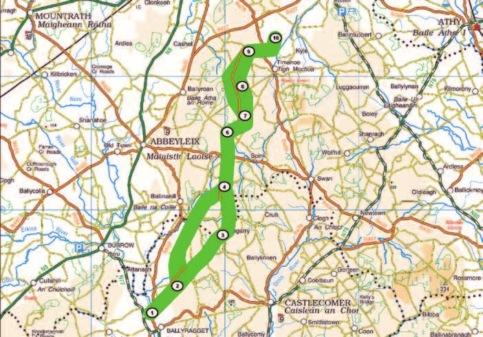
List of Appendices
Appendix A-1         Policy on the use of Overhead Line and or Underground Cable
Appendix A-2         110 kV Underground Cable Feasibility Study
Appendix A-3         Environmental Reports in Relation to an Underground Electricity
Appendix A-4         Power System Studies Laois-Ballyragget Cable Feasibility Studies’
Appendix B           Technical Comparison of AIS vs. GIS Substation Option
Appendix C-1         Full Constraints Map
Appendix C-2         Description of Project Constraints
Appendix C-3         ESB Data and Bord Gais Data Map
Appendix C-4         Natural & Archaeological Features Map
Appendix C-5         Development Plan Designations Map
Appendix D-1         Study Area Constraints Report - Human Beings
Appendix D-2         Study Area Constraints Report - Cultural Heritage
Appendix D-3         Study Area Constraints Report – Landscape
Appendix D-4         Study Area Constraints Report – Ecology
Appendix D-5         Study Area Constraints Report - Soils & Geology
Appendix D-6         Study Area Constraints Report - Hydrology & Hydrogeology
Appendix D-7         Wintering Bird Surveys March - April 2010
Appendix D-8         Wintering Bird Surveys Oct - Dec 2010
Appendix D-9         Wintering Bird Surveys Dec - Jan 2011
Appendix E           List of Statutory and Non Statutory Consultees
Appendix F-1         Newspaper Notice 1: Oct 2009
Appendix F-2         Assessment of Alternative 400/110 kV Substation Study Areas
Appendix F-3         Newspaper Notice 2: June 2010
Appendix G           400/110 kV Emerging Substation Site
Appendix H-1         400/110 kV Route Corridor Map with Constraints
Appendix H-2         Route Corridors - No Constraints
Appendix I-1         Assessment of Corridors Report - Human Beings
Appendix I-2         Assessment of Corridors Report - Cultural Heritage
Appendix I-3         Assessment of Corridors Report - Landscape
Appendix I-4         Assessment of Corridors Report - Ecology
Appendix I-5         Assessment of Corridors Report - Soils & Geology
Appendix I-6         Assessment of Corridors Report - Hydrology & Hydrogeology
Appendix J-1         Emerging Route Corridor with Constraints
Appendix J-2         Emerging Route Corridor No Constraints
Appendix J-3         Emerging Route Corridor on its own with Constraints
Appendix J-4         Emerging Route Corridor on its own without Constraints

                                                                                         5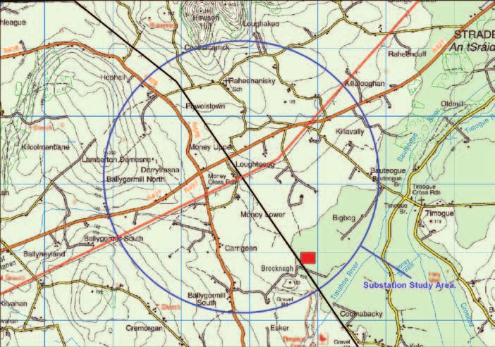
List of Figures:
    Figure 1:          Development Location
    Figure 2:          Photograph of a 400kV Single Circuit Intermediate Tower
    Figure 3:          Photograph of a 400kV Double Circuit Intermediate Tower
    Figure 4:          Photograph of a Single Circuit 110 kV wood poleset structure
    Figure 5:          Photograph of a typical Single Circuit 110 kV angle tower structure
    Figure 6:          AIS Type 400/110kV Substation
    Figure 7:          GIS Type 400/110kV Substation
    Figure 8:          Project Roadmap
    Figure 9:          Laois-Kilkenny Reinforcement Project, Project Study Area
    Figure 10:         The Site Selection Process
    Figure 11:         Substation Study Area
    Figure 12:         Emerging Preferred Substation Site
    Figure 13:         Line Route Corridors
    Figure 14:         Emerging preferred 110kV Route Corridors
    Figure 15:         Emerging preferred 110kV Route Corridors with nodes 7-9 and nodes 7-8-9 amalgamated
    Figure 16:         Emerging Preferred 110kV Route Corridor
    Figure 17:         Emerging Preferred 400kV and 110kV Route Corridors

6
List of Tables:
Table 1:          Sites of known ecological importance, as identified in the constraints report, occurring within
                  3 km of the Western 110kV Route Corridor. WS – Wetland site of importance to waterbirds.
Table 2:          Sites of known ecological importance, as identified in the constraints report, occurring within
                  3 km of the Central Route Corridor. WS – Wetland site of importance to waterbirds.
Table 3:          Sites of known ecological importance, as identified in the constraints report, occurring within
                  3 km of the Eastern 110 kV Route Corridor.
Table 4:          Sites of known ecological importance, as identified in the constraints report, occurring within
                  3 km of Sub Corridor Node 2 -4. WS – Wetland site of importance to waterbirds.
Table 5:          Sites of known ecological importance, as identified in the constraints report, occurring within
                  3 km of Sub Corridor Nodes 3- 7.
Table 6:          Sites of known ecological importance, as identified in the constraints report, occurring within
                  3 km of Sub Corridor Nodes 5 -6.
Table 7:          Sites of known ecological importance, as identified in the constraints report, occurring within
                  3 km of Sub Corridor Nodes 8 - 10.
Table 8:          Sites of known ecological importance, as identified in the constraints report, occurring within
                  3 km of Sub Corridor Nodes 7 - 9.
Table 9:          Route Corridor Appraisal Ratings
Table 10:         Primary Appraisal of the 400kV Route Corridor
Table 11:         Primary Appraisal of the Western Route Corridor
Table 12:         Primary Appraisal of the Central Route Corridor
Table 13:         Primary Appraisal of the Eastern Route Corridor
Table 14:         Primary Appraisal of the Sub Route Corridors
Table 15:         Environmental consultants Corridor Preference

                                                                                                                    7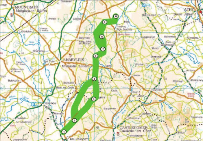
Part A – Project Overview
    1.0 Introduction
    1.1   Project Justification
    The Laois-Kilkenny Reinforcement Project is required to address future impending constraints on the transmission
    network in the Midlands and South East Region. Although the proposed infrastructure will span between County Laois
    and County Kilkenny, it will improve quality of supply and security of supply to the wider region as a whole, including
    counties Laois, Kilkenny, Kildare, Carlow and Wicklow.

                       Development Location

    Figure 1: Development Location (Source = Figure I-2, ‘Map of Planned Transmission Network at Dec 2016’ taken from
    the EirGrid Transmission Forecast Statement 2010 – 2016)

    Transmission Network Constraints:
    Electricity supply constraints or problems that are imminent in the area can be categorised into two specific areas,
    namely:
    1. Quality of Supply; and
    2. Security of Supply

    1. Quality of Supply
    Quality of supply is typically indicated by the voltage level. A deterioration in quality of supply in a transmission network
    is typically seen as lower voltages; an increase in the potential for voltage depressions and a closer proximity to voltage
    collapse.
    The limits of what is considered acceptable and safe for customers are established by a prescribed set of Transmission
    Planning Criteria (TPC) to which EirGrid plans the transmission network. Detailed technical studies indicate that a
    decline in the quality of supply can be expected which will result in breaches of these TPC. It is on this basis of breaches
    in these planning criteria that this reinforcement is now required.
    As part of the ongoing process of implementing reinforcements to ensure compliance with the TPC, a capacitor bank
    was recently installed in Kilkenny substation in order to address the current concerns. A capacitor bank is a piece of
8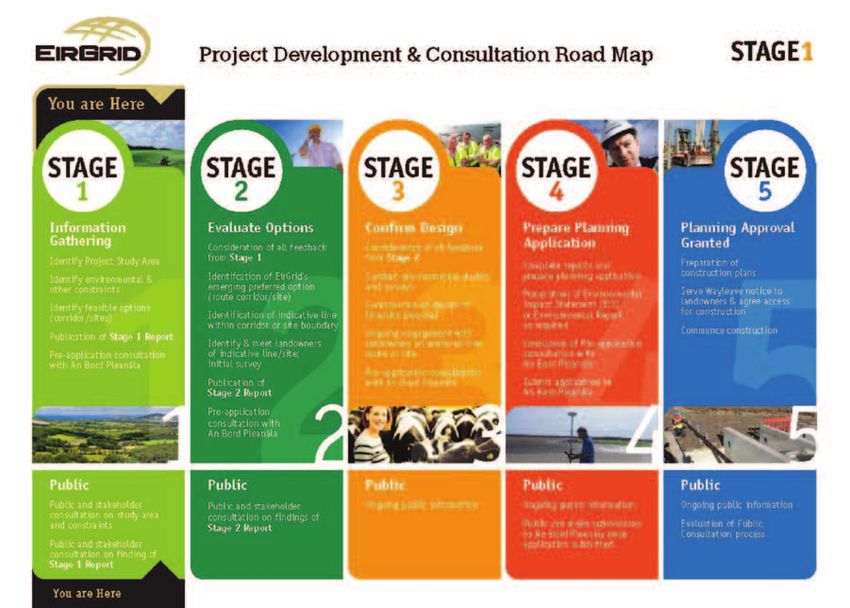
equipment installed in a substation that is used to regulate voltage on the local network. This can only be seen as a short
term solution and a long term solution in the form of the Laois-Kilkenny Reinforcement project is now required.

2. Security of Supply
Security of supply is primarily concerned with ensuring continuity of supply to a customer/consumer. Based on the TPC,
the larger the load or demand, the greater is the imperative to ensure continuity of supply to that load/demand.
  • The typical approach for a town of Kilkenny’s load (demand) size, would be to have three transmission lines supplying
    power to the town.
  • With the existing two line configuration, if one of the lines feeding Kilkenny was out for maintenance the supply is
    reliant on just one remaining overhead line. If a fault occurred on the remaining working line then the supply to
    Kilkenny would be lost, seen as a blackout to customers in the local area.
  • Therefore concerns relating to security of supply primarily affects Kilkenny substation and are not a direct issue for
    Portlaoise substation. Portlaoise is currently served by 4 no. 110 kV overhead lines, whilst Kilkenny is served by just
    2 no. overhead lines. Portlaoise is therefore considered to be more secure than Kilkenny.

The proposed solution will provide adequate security of supply to Kilkenny by way of a new 110 kV circuit from Laois to
Kilkenny.
Additional Benefits
By its very nature, the addition of new transmission infrastructure has the beneficial effect of incrementally increasing the
capacity of the network to accommodate a step change in load. Such a step increase in capacity would have the benefit
of supporting any efforts to attract new loads to the area. Together with the improvement to quality of supply and security
of supply, this would further support any efforts to attract industrial and other high value load customers that are sensitive
to the quality of power supply.
Summary
In summary, by adding the proposed infrastructure to the existing transmission network it will significantly improve the
quality, power flow and security of supply to the region. Although the proposed new circuit runs directly between Laois
and Kilkenny, as it forms part of a meshed transmission network, it will benefit the region as a whole. It is not simply a
case of benefitting Laois or benefitting Kilkenny. The transmission network is the vital backbone of the power system and
will improve the following:
  • The quality of supply to the area will be enhanced with the addition of new transmission circuits and the injection
    of the 400 kV in-feed into the area.
  • The security of supply to the area will be improved ensuring that the area will remain unaffected by any single line
    outage. Currently, single contingencies (meaning the loss of a circuit in the region (due to maintenance or a fault))
    will become an issue even for moderate load growth scenarios for the area.
  • The capacity of the system to deliver more power to the area is increased. The ability of the existing transmission
    network to support and sustain further load growth, or the addition of substation new loads in the area is enhanced.
  	This will support any initiatives to attract new industrial (or any other large scale facilities) to the area.

1.1.1	Technical Alternatives Considered
The problems described above have existed on the system for a number of years and various solutions and alternatives
have been considered before arriving at the proposed solution.
It should be noted that these are electrical studies based on power flow analysis to assess their suitability or otherwise.
Technical studies have been ongoing for some time with results documented since January 2005, finally culminating in
the internal decision to expedite a reinforcement project in the region being made in April 2008.
Similar reinforcement options have been identified and considered throughout the period during which investigations
were conducted. The following regional reinforcement options were identified as being viable alternatives to address the
identified problems, namely:
  • Option A: 400 kV reinforcement option - A new 400/110 kV station at Laois which loops into the existing
    Dunstown-Moneypoint 400 kV line and the Athy-Portlaoise 110 kV line; and a 110 kV circuit between Laois and
    Kilkenny via Ballyragget.

                                                                                                                                 9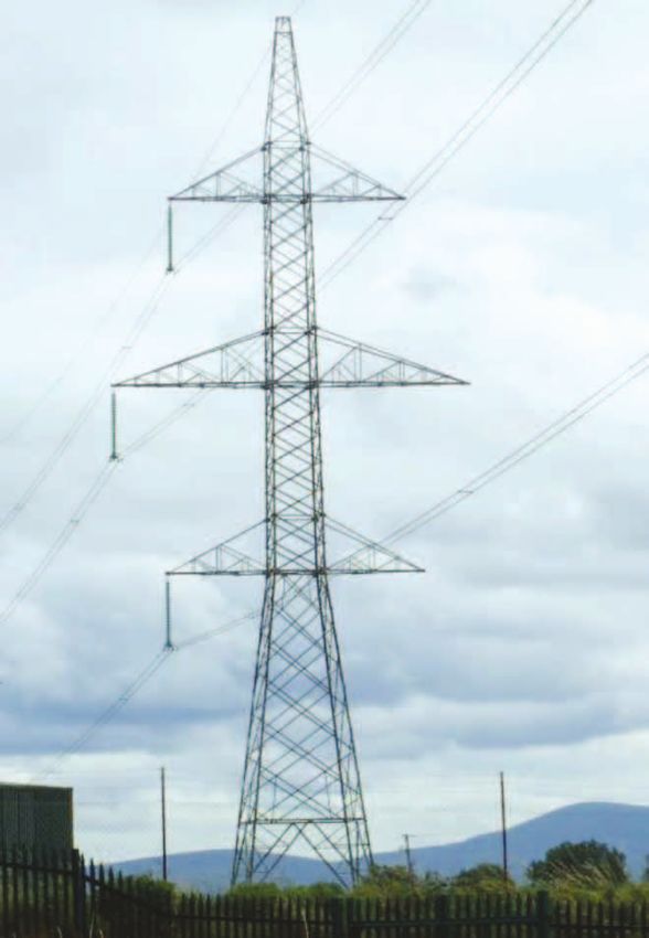
• Option B: A combination 400 kV and 110 kV reinforcement option - A 220/110 kV injection point at Dunstown
         400/220 kV station. New 110 kV circuits: Dunstown-Monread 110 kV circuit; Dunstown-Pollaphuca 110 kV
         circuit; and Carlow – Kilkenny 110 kV circuit.
       • Option C: 110 kV reinforcement option - New 110 kV circuits: Maynooth-Monread 110 kV circuit; Carlow
         -Kilkenny 110 kV circuit; and Kilkenny-Lisheen via Ballyragget 110 kV circuits.
       • Option D: A combination of 220 kV and 110 kV reinforcements - a new 220/110 kV station in Kilkenny looped into
         the existing Great Island-Kellis 220 kV line; new 110 kV circuits: Carlow-Portlaoise 110 kV circuit; and Maynooth
         Monread 110 kV circuit.

     These options are consistent with those originally contemplated as part of the project justification leading to the
     recommendation of the 400kV reinforcement options – referred to as Option A above. These options include modifications
     or adjustments where necessary to respond to the recent economic developments within Ireland and their impact on the
     demand for electrical energy; and to account for the greater clarity and commitment from generators who are expected
     to connect within the region the options that were originally considered were reviewed and adjusted where necessary.
     EirGrid has therefore identified the following solution in response to the technical problems currently affecting the
     transmission system in the general Midlands / South East area:
       • A new 400/110 kV substation near Portlaoise, Co. Laois. The existing Carlow-Portlaoise 110 kV and the
         Dunstown-Moneypoint 400 kV overhead lines will connect into this new substation.
       • A new 110 kV extension to the existing 38 kV substation in Ballyragget, Co. Kilkenny.
       • A new 110 kV circuit between the above substations in Laois and Ballyragget.
       • Change in operational voltage of the existing Ballyragget-Kilkenny overhead line from 38 kV to 110 kV including
         necessary works at Kilkenny 110 kV substation.

     This reinforcement of the transmission system between Laois and Kilkenny is vital in order to improve both quality and
     security of supply to the general Laois, Kilkenny, Carlow, Kildare and Wicklow regions.

     1.2	The Purpose of this Report
     The purpose of this Phase 1 – Lead Consultant’s Report is to present what is considered by ESB International to be the
     emerging preferred substation site and also the emerging preferred corridor within which to locate the proposed new
     110 kV circuit. The emerging preferred 400 kV corridor from the existing 400 kV overhead line to the substation site is
     also identified.
     ESB International are the Lead Consultants for the project but have engaged AOS Planning Ltd as Environmental Sub-
     consultants.
     It is the intention that the information contained herein will enable consultation between the project team and all interested
     parties. This a continuation of the information gathering process that has occurred to date and any feedback on the
     findings to date will be evaluated in the subsequent stage of the project.
     Upon publication of this report there will be a time period during which it will be possible for all stakeholders to provide
     feedback on the emerging preferences. This feedback will be evaluated and assessed by the Project Team which may or
     may not result in modifications to the original preferences.

     This report therefore sets out to:
       • Present the need for the project.
       • Establish a study area for the project.
       • Identify any constraints within the defined study area.
       • Identify potential substation site locations and evaluate same having regard to environmental and
         engineering constraints.
       • Identify an emerging substation site for the project.
       • Identify potential route corridor options for the project within the defined study area and evaluate same having
         regard to the environmental and engineering constraints.
       • Identify an emerging preferred corridor for the project within which to route the proposed 110 kV circuit and the
         400 kV circuit required to connect to the substation in Laois.

10
1.3 About EirGrid
EirGrid is the state owned independent Transmission System Operator (TSO) and Market Operator (MO) in Ireland.
It is EirGrid’s role to deliver quality connection, transmission, and market services to electricity generators, suppliers
and customers utilising the high voltage electricity transmission system.
The Transmission System (also known as the ‘National Grid’) is a meshed network of approximately 6,500km of
high voltage overhead lines and underground cables and over 100 transmission stations. The transmission system
operates at voltages of 110 kV, 220 kV and 400 kV.
The system can be compared to Ireland’s motorway network – delivering power from generators to over 100 bulk
transfer points or “nodes” all over Ireland similar to motorway interchanges. Power is then carried onwards from
these substation ‘nodes’, to individual customers and households, via the low voltage distribution system similar to
the regional and national road network.
EirGrid has several roles:
• To operate a safe, secure, reliable and efficient national electricity grid.
• To plan and develop the necessary grid infrastructure to support Ireland’s economy.
• To schedule electricity generation with power generators to ensure that supply matches demand.
• To operate the wholesale electricity trading system.
It is in this capacity that EirGrid is proposing this Laois-Kilkenny Reinforcement Project.
1.4 Strategic Planning Context
The purpose of this section is to describe the Strategic Planning Context for this project. This is set out in National,
Regional and Local Policies and Objectives.
1.4.1 National Objectives
White Paper on Energy Policy Framework 2007-2020
The White Paper sets out the current national energy policy framework 2007-2020 to deliver a sustainable energy future
for Ireland.
Strategic goals outlined in the White Paper in relation to security of energy supply include:
• Ensuring that electricity supply consistently meets demand;
• Delivering electricity and gas to homes and businesses over efficient, reliable and secure networks; and
• Being prepared for energy supply disruptions.
The White Paper emphasises that ‘the availability of reliable, secure and competitively priced electricity supply must be
assured at all times’ and highlights the fact that electricity ‘is a vital ingredient in the competitiveness of Irish industry
and Ireland’s long term economic and social development’.
The White Paper also sets the target of 33% of electricity being produced from renewable generation by 2020. This
target was subsequently increased to 40%.
National Development Plan 2007-2013
The National Development Plan 2007-2013 sets out to ensure that Ireland remains competitive in the global international
marketplace and that the fruits of our economic success would be shared more equally at regional level and throughout
our society. A strategic objective of the Energy Programme of the NDP is to ensure security of supply nationally and
regionally. The NDP further states that the main focus of investment by EirGrid ‘will entail improvement of the transmission
network for electricity to accommodate increased usage and enhance security of supply, to allow increased connection
of sustainable and renewable energy sources to the network and to support greater interconnection with Northern
Ireland and Great Britain’.
National Spatial Strategy 2002-2020
The NSS is a 20 year Spatial Planning Strategy, which is a strategic vision for the spatial development of Ireland. It
outlines how a strengthened network of cities and towns together with rural communities and their resources will be
mobilised and complemented by appropriate social and physical infrastructure, to create more balanced development
across the country.
11In relation to key infrastructure projects, the NSS identifies that ‘a feature of the most mature and successful economies
is that they possess highly developed, well integrated infrastructure that supports movement, i.e. public and private
transport, and energy and communications networks.’
The NSS identified nine, strategically located, medium sized ‘hubs’ whose purpose is to work together to promote
regional development in their areas. Kilkenny has been identified as one of these hubs. Some 58% of current demand
for electricity is in gateway cities and towns, as identified in the National Spatial Strategy (NSS). The NSS defines
gateways as having a strategic location, nationally and relative to their surrounding areas, and provide national scale
social, economic infrastructure and support services. The Grid25 (see section 1.3.4) strategy endorses the NSS goal of
developing gateways and achieving balanced regional development.
1.4.2 Regional Objectives
Midlands Region Authority, Regional Planning Guidelines 2010-2022
These Regional Planning Guidelines provide a robust sustainable planning framework for the Midlands Region within
the context of the Planning and Development Act 2000 (as amended), and the National Spatial Strategy 2002-2020.
Importantly not only do they have regard to the National Spatial Strategy in the context of the Midlands Region, but they
also consider the surrounding regions.
Chapter 5 addresses the Region’s ‘Transport and Infrastructure Strategy’. This section recognises that an efficient,
reliable and cost effective electricity supply is a key resource for regional development.
The Regional Planning Guidelines promote the improvement and expansion of the transmission network throughout the
Midlands Region, and includes a section which provides policy framework for Electricity Provision (Section 5.8.1.1, pg
105) as follows:-
• Development Plans should facilitate the sustainable provision of energy networks in principle provided that it can
be demonstrated that:
• The development is required in order to facilitate the provision or retention of significant economic or
social infrastructure
• The route proposed has been identified with due consideration for social, economic, environmental and
cultural impacts
• Where impacts are inevitable mitigation methods have been included
• Where it can be shown that the development is consistent with best international practice.
Transport and Infrastructure Policies are set out in Section 5.10 of the document, and includes policy which supports and
promotes improvement and expansion of the national grid, namely TIP32:
• TIP32 Support and promote the sustainable improvement and expansion of the electricity transmission and
distribution network that supply the Midland Region.
South East Region Authority, Regional Planning Guidelines 2010-2022
The Regional Planning Guidelines (Chapter 3, Section 3.2, Objective A9) sets out the following strategic goal for the
region.
‘Supporting the development and improvement of key economic infrastructure, such as energy generation and
transmission networks, including renewable energies and telecommunications, all of which are essential for the
continued development of the region.’
The Energy Section (Chapter 6, Section 6.2) acknowledges the role of EirGrid and the key transmission projects identified
in the GRID25 (see section 1.3.4) strategy. The need to improve the electricity infrastructure in the region is recognised
in Section 6.2.3.2, which states:
‘The South-East Regional Authority recognises the need to increase electrical infrastructure which will be required
within the region, including development of new ‘main’ 400 kV lines and strengthening of 220 kV , 110 kV transmission
lines and equipment.’
Furthermore, Planning Policy Objective 6.5 states:
PPO 6.5 The Regional Authority supports the sustainable development and expansion of the GRID network and future
connections to renewable sources of energy (including Gate 3 projects), subject to appropriate assessment of all
necessary environmental considerations.
121.4.3 Local Objectives
Laois County Development Plan 2006 - 2012
The current Laois County Development Plan 2006 – 2012 does not contain policies relating to energy networks.
However there are energy policies included in the Draft Laois County Development Plan 2012 – 2018 which are relevant
to the project.
Draft Laois County Development Plan 2012-2018 (Reviewed March 2011)
Chapter 9, Section 9.5 of the Draft Laois County Development Plan lists the new transmission and distribution
infrastructure projects in the area, including the Laois-Kilkenny Reinforcement Project.
Chapter 9 also includes specific policies which support and facilitate the development of enhanced electricity supplies.
Policy ET9/P13 indicates the intention to protect national grid infrastructure by safeguarding strategic infrastructure
corridors from encroachment by inappropriate development. Other policies relating to energy networks include:
ET9/O05 To support and facilitate the development of the electricity infrastructure to ensure a secure supply for the
residents of County Laois and ensure that any plan or project associated with energy generation or supply which has
the potential to significantly affect a Natura 2000 site is appropriately assessed in accordance with Article 6 of the
Habitats Directive in order to avoid adverse impacts on the integrity of the site.
ET9/P11 Support and facilitate the development of enhanced electricity and gas supplies, and associated networks, to
serve the existing and projected residential, commercial, industrial and social needs of the County.
Laois County Council acknowledges the need to utilise electricity for domestic and commercial use within the County.
Kilkenny County Development Plan 2008- 2014
The Kilkenny County Development Plan was adopted in June 2008. Chapter 9 deals with ‘Infrastructure and Environment’.
Kilkenny County Council recognises the critical importance of energy availability to facilitate new development. ‘in support
of sustainable development and efficient energy utilisation, Kilkenny County Council supports the infrastructural renewal
and development of electricity networks in the region, including the overhead lines to provide the required networks,
subject to amenity and health considerations’. (Chapter 9, Section 9.8.1, ‘National Grid’)
1.4.4 GRID25
GRID25 – A Strategy for the Development of Ireland’s Electricity Grid for a Sustainable and Competitive Future (2008)
outlines EirGrid’s high level strategy for upgrading Ireland’s electricity network up to the year 2025, in response to the
government White Paper on Energy Policy.
It should be noted that while they are largely aligned there is some overlap between the boundaries of the Grid 25
regions and the regions as defined by the Regional Authorities.
The sections on the South East and Midlands Region (GRID25) outline the consequences of non action as follows:
• Over the next five to ten years, there will be no capacity in the network to cater for new customers and the reliability
of supply to existing customers will fall below normal international standards;
• There will be no capacity in the network to allow further renewable generation to be connected; this will have severe
consequences on the ability of Ireland to meet its renewable targets and its long term sustainable energy supplies;
Benefits to the region include;
• Future growth in demand from both industry and domestic users can be accommodated;
• Proposals will ensure security of supply to major urban areas and to the region as a whole;
• Increased transmission capacity will allow for growth of renewable generation connections in the region;
131.5 EirGrid Position on Underground Cables
EirGrid has the exclusive statutory function to operate, maintain and develop a safe, secure, reliable economic and
efficient electricity transmission system in Ireland, while having due regard for the environment.
EirGrid has established a position and practices for the construction and operation of high voltage overhead lines and
underground cables in Ireland. Whenever a new high voltage circuit is proposed, this position guides the decision on
whether to use overhead line or underground cable.
EirGrid’s position states that an underground cable will be used only when all of the following conditions apply:
1. An overhead line is not environmentally and/or technically feasible.
2. A technically and environmentally acceptable route for an underground cable can be found.
3. The effect on the transmission network due to the electrical characteristics of the underground cable is acceptable,
and the relative poorer ‘availability’ of the underground cable relative to that of an equivalent overhead line
is tolerable.
4. The relative greater cost of the underground cable when compared to an overhead line can be justified.
The full document ‘Policy on the use of Overhead Line and/or Underground Cable’, GDC-1R001-00, is included in
Appendix A-1.
Notwithstanding this position, the use of underground cable has been considered in detail for this specific project. The
circuit in question is the proposed Laois-Ballyragget 110 kV circuit.
In relation to condition (1) above, Chapters 4, 5 and 6 of this report confirm that there are three environmentally feasible
corridors including variants of these corridors, within which to route a 110 kV overhead line, and that the predicted
environmental impacts of such a development are sustainable. As such, condition (1) does not apply.
In relation to condition (2) above, EirGrid commissioned ESB International to carry out a feasibility study to identify an
underground cable route option. This study identified and evaluated several feasible routes identifying one preferred
route. This study entitled ‘110 kV Underground Cable Feasibility Study’ (Ref: PE424-F0000-R000-011-004) is included
in Appendix A-2. A further environmental study was then carried out on this one cable route. This report found that while
there are some environmental impacts, especially during the construction phase, these can be minimised with appropriate
mitigation measures and the environmental impacts are therefore sustainable. This study is entitled ‘Environmental
Reports in Relation to an Underground Electricity Circuit for the Laois-Kilkenny Reinforcement Project’ and is included
in Appendix A-3. As such condition (2), does apply.
In relation to condition (3) above, a project specific technical screening study has examined the electrical characteristics
of using a cable for the proposed circuit. This study found that whilst the use of a cable would result in a more onerous
utilisation of the local 110 kV network, the overall effect is deemed tolerable. This study entitled ‘Power System Studies:
Laois-Ballyragget Cable Feasibility Studies’ (Ref: PE667-F0400-R300-001-003) is also included in Appendix A-4.
In relation to condition (3) above, the availability of both an overhead line and an underground cable has been assessed
based on a combination of fault data from the Irish Transmission System and from CIGRÉ (Conseil International des
Grands Réseaux Électriques (The International Council of Large Electric Systems)) data on 110 kV faults. From these
it has been concluded that on average, over it’s lifetime an overhead line will give a better service availability than
an underground cable. This is based on the knowledge that, on average, the fault rates of underground cables are
comparable with the fault rates of overhead lines (sustained faults as opposed to transient faults) however the repair
times for underground cable faults (average repair time of 15 days for 110 kV UGC) are considerably longer than for
faults on overhead lines (average repair time of less than one day). It follows therefore that an overhead line will provide
a better level of service availability, and is therefore more reliable than an equivalent underground cable. Based on this
criterion and for this development, an overhead line is considered preferable to an underground cable.
In relation to condition (4) above, the costs for both an overhead line and an underground cable solution have been
estimated. Based on the emerging preferred overhead line route corridor identified in Chapter 6 and the emerging
preferred underground cable route identified in the Underground Cable Feasibility Report, it is estimated that the
underground cable would cost nearly three times more to install than the equivalent overhead line. The relative high cost
of an underground cable cannot be justified given the fact that viable overhead line solutions exist and therefore condition
(4) does not apply.
In summary, EirGrid’s position on the use of high voltage underground cable and overhead line in the Ireland states that
all four of EirGrid’s conditions must apply for an underground cable to be used for a proposed circuit.
As only one of the four policy conditions is applicable, EirGrid are proceeding with an overhead line solution for the Laois-
Ballyragget 110 kV circuit.
141.6 General Project Description
The proposed Laois-Kilkenny Reinforcement Project will consist of the following:
• A new 400/110 kV substation near Portlaoise, Co. Laois. The existing Carlow-Portlaoise 110 kV and the Dunstown-
Moneypoint 400 kV overhead lines will connect to this new substation.
• A new 110 kV extension to the existing 38 kV substation in Ballyragget, Co. Kilkenny.
• A new 110 kV circuit between the new 400/110 kV substation near Portlaoise and the new 110 kV substation
extension in Ballyragget, Co. Kilkenny.
• Change in operational voltage of the existing Ballyragget-Kilkenny overhead line from 38 kV to 110 kV including
necessary works at Kilkenny 110 kV substation.
The existing Dunstown-Moneypoint 400 kV overhead line will be connected to the planned new substation in Laois1.
This connection will be made using a combination of 400 kV double circuit and single circuit lines. A double circuit line
consists of six electrical conductors and one earthwire, while a single circuit line consists of three electrical conductors
and two earthwires. At 400 kV level steel lattice towers are used to support the conductors.
The existing Carlow-Portlaoise 110 kV overhead line will also be connected to the planned new substation in Laois2. This
connection will be made using single circuit lines (a single circuit line consists of three electrical conductors and two
earthwires). At 110 kV level, woodpole portal structures are used to support the conductors. Where the line changes
direction steel lattice towers are used.
It is also intended to construct the new ‘Ballyragget to New 400/110kV Substation’ 110kV circuit as a single circuit
overhead line3.
1
The emerging preferred substation site is approximately 1.5km from the Dunstown-Moneypoint 400kV line – see section 3 “Substation Site Identification”
2
The emerging preferred site is adjacent to the Carlow-Portlaoise 110kV line – see section 3 “Substation Site Identification”
3
The emerging preferred line route corridor is approximately 26km – see section 6.4 Lead Consultant’s Recommendation
151.7 Typical Structures Description
1.7.1 Overhead Line Structures 400 kV
400kV overhead lines are carried on steel lattice towers. There are two types of structures that are proposed for the
Laois – Kilkenny Reinforcement Project; these are Single Circuit towers and Double Circuit towers.
Single Circuit Intermediate and Angle Structure
Lattice steel towers are used to carry 400 kV overhead lines. They typically range in height from circa 26 – 55 metres
depending on the ground profile. These structures hold three conductors, connected to electrical insulators along the
lower crossarm and two earthwires supported on the earthwire peaks of the mast. Figure 2 shows a photograph of a
400kV lattice steel towers which are similar to the one of the types of towers proposed for the new short length of 400kV
overhead line.
Figure 2: Photograph of a 400kV Single Circuit Intermediate Tower
Double Circuit Intermediate and Angle Structure
In some instances, the most efficient method of carrying two circuits along the same route is to use a double circuit angle
tower. As its name implies, a double circuit tower is capable of carrying two circuits (6 conductors) with an earthwire
supported on the top. As they are supporting more weight, these structures are taller than the single circuit angle towers.
Their typical heights can range from circa 50 – 68 metres, Figure 3 shows a photograph of an existing double circuit
steel intermediate tower on a 400 kV line which is similar to the one of the types of towers being planned for the new
400kV overhead line.
16Figure 3: Photograph of a 400kV Double Circuit Intermediate Tower
Note: Only one side of this tower has conductor attached. The proposals outlined in this report will have conductors on
both sides. The wire on top is known as an earthwire which protects the conductors from lightning strikes.
171.7.2 Overhead Line Structures 110 kV
Two types of structures are used to carry 110kV overhead lines. These are woodpole portal structures (predominately)
and lattice steel angle towers where the line changes direction.
Single Circuit Intermediate Woodpole Portal Structure
Overhead line intermediate woodpole portal structures consist of two wood poles, 5 metres apart, connected near the
top with a rolled steel channel. The full length of the wood poles varies from 16-23m with a minimum 2.3m of this buried
underground. The polesets carry three conductors (also known as phases) suspended from electrical insulators. These
conductors carry the electrical current. Two earthwires are supported on top of the poles on earthwire brackets which
extend 0.45 metres above the top of the pole. These earthwires do not carry electrical power and serve only to protect
the overhead line and connected equipment from lightning strikes.
Figure 4 shows a photograph of an existing 110 kV line which would be similar to the proposed Ballyragget – Laois 110
kV line.
Figure 4: Photograph of a Single Circuit 110 kV wood poleset structure
Single Circuit Angle Structure (Lattice Steel Angle Tower)
Lattice steel angle towers are used on 110 kV overhead lines where the line changes direction. They typically range
in height from circa 17 – 24 metres depending on the ground profile. The angle structure holds three conductors,
connected to electrical insulators in a horizontal formation along the lower crossarm. Two earthwires are supported on
the earthwire peak of the mast (upper crossarm). Figure 5 shows a photograph of an existing steel angle tower on a 110
kV line which would be similar to those found on the proposed Laois-Ballyragget overhead line.
18Figure 5: Photograph of a typical Single Circuit 110 kV angle tower structure
1.8 Station Descriptions
A substation is the location where equipment is placed in order to safely change the electricity from higher transmission
voltages to lower voltages that are appropriate for use by end-customers. It does this by using equipment known as
transformers. They ‘transform’ the electricity from one voltage to another and they represent the means through which
electricity is drawn from the transmission system.
A substation also acts as a point of common connection or a ‘node’ for several circuits. It is helpful to think of them like
a roundabout. Power comes in on one circuit (road) and can be sent down another circuit. This is achieved by using
other equipment in the substation such as switches and circuit breakers. All of this equipment together is known as a
substation.
New Laois 400/110 kV Substation
Two alternative types of substation were considered for this particular project. One is an outdoor type, known as an Air
Insulated Switchgear (AIS) substation. The second type is an indoor type, known as a Gas Insulated Switchgear (GIS)
substation.
As their name suggests, both use different insulating mediums (Air or Gas) between hardware devices (circuit breakers)
within the station. Smaller distances between parts can be achieved with gas as its insulating strength is higher than
that of air, resulting in a more compact overall station size. The land take size associated with the GIS stations can be
significantly smaller than when compared to AIS.
In Laois, it is estimated that the AIS compound would be approximately 11.6 acres (4.68 hectares) in size, whilst the GIS
compound would be of the order of 2.6 acres (1.06 hectares) in size.
A typical 400/110kV AIS substation compound consists of a control building typically circa 15m x 25m x 7m in height.
All of the switchgear is outdoors. The highest elements of this substation are several lightning protection structures
spaced around the compound which are typically circa 28m in height; Figure 6 illustrates an indicative 400/110kV AIS
substation layout.
19Figure 6: AIS Type 400/110kV Substation
A typical 400/110kV GIS substation compound consists of a 400kV building, typically circa 12m x 43m x 11m in
height and a 110kV building typically circa 27m x 10m x 8m in height. These buildings contain the switchgear. The
power transformers are located next to the 400kV building and are separated by a fire wall. The highest element of this
substation is a single lightning protection structure in the centre of the compound which is typically circa 28m in height;
Figure 7 illustrates an indicative 400/110kV GIS substation layout.
Figure 7: GIS Type 400/110kV Substation
When considering the type of substation to use, land take is only one consideration. Technical performance including
operational flexibility and maintenance as well as comparative costs must also be considered.
ESBI carried out a comparison report on the substation technology options and the recommendation was to proceed
with a GIS solution. This recommendation was based on both the cost and technical aspects as well as taking into
account the overall smaller size and the associated reduced environmental impact. This Report is entitled ‘Technical
Comparison of AIS vs. GIS Substation Options’ (Ref: PE595-F1268-R268-003-003) and can be found in Appendix B.
20Having considered this recommendation, EirGrid have decided that it is appropriate to proceed with a GIS type substation
in this particular instance.
It is planned that the existing 400 kV Dunstown-Moneypoint and 110 kV Carlow-Portlaoise overhead lines will connect
into this new GIS station by way of overhead lines.
It is also planned to construct a new 110 kV overhead line from this GIS substation to Ballyragget.
Ballyragget 110 kV Substation Extension
Ballyragget substation is a 38kV/MV substation. To facilitate the requirements of this reinforcement project a new 110
kV extension is required. This new extension will consist of 110 kV busbar, 110 kV line bays and 110 kV transformer bays
and will interface with the existing 38kV/MV station.
The extension will be a compact AIS extension and the size will be similar to what is already there. (i.e. 0.5 acres). Local
realignment and rearrangement of the existing overhead line into the station will be required.
Kilkenny Substation
The existing Ballyragget-Kilkenny overhead line is currently constructed to 110kV but operating at 38 kV and as such is
connected to the 38 kV busbar in Kilkenny station. As described in the project description, it is intended to operate this
line at the higher voltage of 110 kV. The line will therefore need to be moved from the 38 kV busbar to the 110 kV busbar.
This may entail some realignment of the existing structures close to the station.
1.9 Project Roadmap
A project roadmap outlining the key phases/stages of the project, from beginning through to submission of planning
application is shown in figure 8. This report represents the conclusion of Phase/Stage 1.
21Figure 8: Project Roadmap 22
1.10      Project Team
ESB International has been appointed by EirGrid as the Lead Consultant for this project.
Specialist environmental reports / inputs have been prepared by AOS Planning Ltd. and their subconsultants.

1.11	Health and Safety
ESB International has been appointed as Project Supervisor Design Process (PSDP) and Designers for the Laois –
Kilkenny Reinforcement Project and will fulfil all relevant duties as defined by the Safety, Health and Welfare at Work
(Construction) Regulations 2006 (S.I No 504).
ESB International will therefore ensure that the principles of prevention are applied throughout the design process and
that the proposed development submitted to the Planning Authority is:
a) designed and is capable of being constructed safely and without risk to health
b) able to be maintained safely and without risk to health during use, and
c) compliant in all respects, as appropriate, with the relevant health and safety statutory provisions.

                                                                                                                          23
2.0 Study Area and Constraints Identification
2.1 Study Area Identification and Description
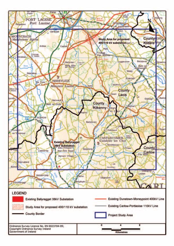
The Project Study Area is the broad geographical region within which a practical feasible route corridor can expect to
be found having regard to the technical rationale for the project as outlined in chapter 1. In this case it covers an area
of approximately 29 x 30km (870 sq km). This study area was established taking into consideration the connection
requirements for the project. These requirements include connection to the existing Dunstown-Moneypoint 400 kV
overhead line, connection to the existing Carlow-Portlaoise 110 kV overhead line and a connection to a new 110 kV
extension of the existing Ballyragget 38 kV substation. This study area has been reviewed by AOS Planning Ltd. and is
deemed to be an appropriately sized study area based on the objectives of the project.
The Project Study Area mainly lies within the counties of Laois and Kilkenny. The Project Study Area is bounded to the
north by Portlaoise, to the east by Athy, to the west by Mountrath, and to the south by Freshford.
It is generally rural in nature and is generally characterised by farmland interspersed with towns, villages and settlements
connected by a network of national, regional and local roads.
The landscape of the Project Study Area is mainly characterised by lowlands through which the River Nore flows and
higher ground underlain by the Castlecomer Plateau. The lowlands in the western section are underlain by limestone and
are generally flat and have fertile soils. The area is dominated by farmland, with a network of fields containing improved
grasslands and tillage, with a well developed hedgerow network.
The Castlecomer Plateau area contains higher ground extending up to 330m Ordnance Datum (OD) and is underlain
by shales and sandstone. This area has an undulating hilly landscape with low peaks and some low-lying valleys that are
drained by tributaries of the River Nore. This type of environment and geology means that soil is less fertile with impeded
drainage, and as a result wet grasslands are a prominent feature of these hillsides. Conifer plantations are also regularly
found in this area. Elevation in the study area ranges from 60 metres (m) OD along the River Nore channel to 326m OD
near Fossy Mountain.
The majority of this project study area is found within the River Nore catchment and the proposed site of the 110kV
substation at Ballyragget is situated near the river adjacent to the existing 38kV substation. A section on the eastern side
of the study area lies within the Barrow catchment. Figure 9 shows the Project Study Area
24Figure 9: Laois-Kilkenny Reinforcement Project, Project Study Area
252.2 Identification of Constraints
The identification of environmental and other constraints within the study area assists in determining potential locations
for the planned infrastructure. Constraints can generally be divided into three principal categories, namely:
• Natural Constraints (naturally occurring landscapes and features)
• Man made Constraints (forming part of the built environment)
• External Parameters (design standards, policy, procedural and legal issues)
A ‘Constraints Map’ (Ref: PE687-D261-001-004-003) was produced during the earlier part of this Phase 1, and this
can be seen in Appendix C-1.
A supplementary ‘Toolkit’ explanatory report of the constraints identified within the study area was also produced. This
report is entitled ‘Description of Project Constraints’ (Ref: PE687-F0261-R261-004-002’) and this can also be found
in Appendix C-2.
Constraints were identified through the following process:
• Review of the Planning and Environmental Legislation. All EirGrid projects comply with current planning and
environmental legislation.
• Evaluation of Study Area by Environmental Consultants. Environmental Consultants were commissioned to analyse
the study area in order to identify environmental constraints. The detailed reports are found in Appendix D-1, D-2,
D-3, D-4, D-5, D-6, D-7, D-8 & D-9.
• Aerial Photography. Aerial Photography for the entire study area was acquired. This aerial photography was used
as a basis for the constraints mapping and was itself used as a means of identifying and confirming environmental
and other constraints within the area.
• OSI Mapping. OSI Mapping (Ordnance Survey Ireland), was obtained and used to identify potential constraints.
• Consultation. Part of the process for the identification of constraints includes consultation with statutory and non
statutory consultees including the general public (see section 2.4).
• An Post Geodirectory. The An Post Geodirectory information was obtained and mapped along with ongoing reviews
of publically available data from Laois and Kilkenny County Councils.
• Site Visits. Regular site visits were made by the project team to the study area to familiarise themselves with and to
confirm all of the identified constraints therein.
• ESBI GIS Database. ESBI hold a database of environmental data including Special Areas of Conservation (SAC’s),
Special Protection Areas (SPA’s), Natural Heritage Areas (NHA’s) and proposed Natural Heritage Areas (pNHA’s)
sourced from the National Parks and Wildlife Service (NPWS). Also on record are the Forestry Planning and
Inventory System (FIPS) data sourced from Coillte and the Sites and Monuments Records (SMR’s) data soured
from www.archaeology.ie.
2.3 Constraints Map Production and Summary
A Project Constraints Map (PE687-D261-001-004-003) was produced and is included in Appendix C-1.
As some constraints may overlap with other constraints, in addition to the master map (Appendix C-1), to assist viewing,
three ‘sub-maps’ have also been produced which separate the constraints into appropriate groupings. These are listed
below and are also included in Appendix C-3, C-4 & C-5.
• ESB and Bord Gais Data, (Appendix C-3)
• Natural and Archaeological Constraints , (Appendix C-4)
• County Development Plan Designations , (Appendix C-5)
To assist the reader in viewing the ‘Constraints Map’ and understanding the types of constraints found in the Project
Study Area, a short report, ‘Description of Project Constraints’ (PE687-F0261-R261-004-002) has also been produced
(Appendix C-2).
26The Study Area was examined under the following headings by environmental consultants:
• Human Being
• Cultural Heritage
• Landscape
• Ecology (Flora and Fauna)
• Soils and Geology
• Hydrology and Hydrogeology
These Reports can be found in Appendix ‘D-1, D-2, D-3, D-4, D-5 & D-6’. Seasonal ornithology Reports were also
commissioned to assess the abundance and distribution of wintering wader and wildfowl birds within the study area.
These are ongoing at the time of writing; however there are three interim reports available that can be seen in Appendix
D-7, D-8 & D-9.
Constraints have been classified as ‘Man-Made Constraints’ or ‘Natural Constraints’.
2.3.1 Man-made Constraints
2.3.1.1 Human Beings
(Please see Appendix D-1 for the ‘Study Area Constraints Report - Human Beings’)
The key constraints in relation to Human Beings are the following:
Settlements – Towns including Strabally, Timahoe, Ballyroan, Ballylynan, Luggacurren, Abbeyleix, Ballycolla, Durrow,
Ballinakill, Castlecomer, Ballyragget, as well as smaller villages and one off housing scattered throughout the area,
primarily along local and regional roads.
Areas of Tourism Interest – The location of structures in and relative to, areas of scenic importance need to be carefully
considered in order to minimise the landscape impact and associated attractiveness of the area for tourism and amenity
purposes.
The main features of tourism within the study area include: The River Nore SAC, the Heritage Town of Abbeyleix,
the Abbeyleix Wood Complex, views overlooking Castlecomer and Ballyragget and views towards the Slieve Bloom
Mountains, Timahoe Round Tower and heritage gardens and parks (for example Heywood Gardens).
2.3.1.2 Cultural Heritage
(Please see Appendix D-2 for the ‘Study Area Constraints Report - Cultural Heritage’)
The archaeological and architectural heritage features located within the study area can be categorised under the
following headings:
National Monuments: Three national monuments in state ownership are located within the study area and all are located
within the vicinity of Timahoe, Co. Laois.
Recorded Monuments: 993 recorded monuments including 15 redundant records are located within the study area
Protected Structures: See below.
National Inventory of Architectural Heritage: 385 structures listed in the NIAH are located within the study area. 179 of
these are found in Laois, and 206 in Kilkenny. The majority of sites are located within towns or villages.
All of the cultural heritage sites identified within the study area represent constraints to the proposed overhead lines and
substation. The cultural heritage features data from the Bronze Age through to the modern period and the overall density
of sites within the study area is considered high. Noticeable distribution patterns include the high numbers of enclosures
and ringforts (384), and churches (70) which occur within the study area. River banks are areas of archaeological
potential / sensitivity and this should be considered in the route selection process. Whilst upland areas appear to have
fewer recorded sites, this is due mainly to the lack of detailed upland archaeological surveys which have been carried out
to date. This is the case within this study area where there appears to be a limited number of monuments over upland
areas. Of particular note in the study area are the presence of field systems and deserted medieval settlements. These
are extensive monuments on the ground and span over several fields.
27You can also read