Humber river basin district Flood Risk Management Plan 2015 to 2021 Habitats Regulation Assessment - March 2016 - Gov.uk
←
→
Page content transcription
If your browser does not render page correctly, please read the page content below
Humber river basin district
Flood Risk Management Plan 2015
to 2021
Habitats Regulation Assessment

March 2016

                  1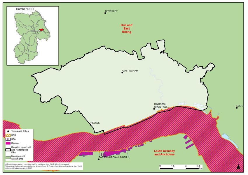
Executive summary
The Flood Risk Management Plan (FRMP) for the Humber River Basin District (RBD)
provides an overview of the range of flood risks from different sources across the 15
catchments of the RBD and more specifically from local flood sources in the 3 Flood Risk
Areas (FRAs) of Kingston-upon-Hull and Haltemprice, West Midlands and Leicester Principal
Urban Area. The RBD catchments are defined in the River Basin Management Plan (RBMP)
and based on the natural configuration of bodies of water (rivers, estuaries, lakes etc.). The
3 FRAs were identified as having higher local flood risk by the Preliminary Flood Risk
Assessments.

The FRMP provides a range of objectives and programmes of measures identified to
address risks from all flood sources. These are drawn from the many risk management
authority plans already in place but also include a range of further strategic developments for
the FRMP ‘cycle’ period of 2015 to 2021. The range of measures in the Humber RBD FRMP
are reported under the following types of flood management action:

Types of flood management measures                                      % of RBD measures

Prevention – e.g. land use policy, relocating people at risk etc.                      33%
Protection – e.g. various forms of asset or property-based protection                  39%
Preparedness – e.g. awareness raising, forecasting and warnings                        22%
Recovery and review – e.g. the ‘after care’ from flood events                           2%
Other – any actions not able to be categorised yet                                      3%

The purpose of the HRA is to report on the likely effects of the FRMP on the network of sites
that are internationally designated for nature conservation (European sites), and the HRA
has been carried out at the level of detail of the plan. Many measures do not have any
expected physical effects on the ground, and have been screened out of consideration
including most of the measures under the categories of Prevention, Preparedness, Recovery
and Review. Others that may have effects but are in catchments that do not have any
designated European sites have also been screened out of consideration.

Risk Management Authorities (RMAs) have for a long time been addressing the range of
flood risks through a range of plans and actions. Much of the Humber RBD FRMP presents
measures that are ongoing from existing plans, which have already been subject to HRA.
RMAs have considered the effects of these existing plan measures on European sites in
published HRAs where required. These measures, their effects and agreed actions to
mitigate the effects have been summarised under relevant RBD catchments and FRAs
within this report. Where RMAs have identified new flood risk management priorities for the
next FRMP cycle period between 2015 and 2021, then the measures to implement these
have been considered alongside existing plan measures in this HRA.

The following table summarises the numbers of measures that the HRA has considered:
Screened out       Measures from              New cycle 1
FRMP RMA plans
                                              measures         existing plans             measures1
Humber RBD catchments                                  655                   135                    216
FRA Kingston-upon-Hull and
                                                         26                    0                        12
Haltemprice
FRA West Midlands                                        79                    7                         0
FRA Leicester Principal Urban Area                       17                    0                         0

Total                                           787 (68%)             142 (12%)              228 (20%)

The HRA has been carried out for the set of measures for each RBD catchment that address
main river, sea and reservoir flooding alongside any measures volunteered by RMAs that
address local flooding and thus form a ‘RBD plan’ within the FRMP. Measures within FRAs
that address high risk of local flooding in these areas have been considered in the HRA as
separate ‘FRA plans’ within the FRMP. Both ‘RDB plan’ and ‘FRA plans’ are further
considered in-combination by the HRA. The findings are a summary of the risks to European
sites and an indication of the need for future HRAs at a project level when developing local
actions, as well as considering how to avoid and mitigate any residual risks to European
sites.
For the Humber RBD FRMP, the main conclusions from the stages of assessment across all
4 RMA plans of the FRMP are as follows:

A determination was made to screen out measures that would not have physical effects on
any European sites.

The effects of the measures from existing plans include effects of measures to address
coastal flooding from SMPs, measures to address main river flooding from CFMPs and
measures to address local flooding from local strategies. Existing controls and mitigation
from these plans include: for SMPs, development of coastal strategies, accompanied by
more detailed HRAs for relevant SMP Policy Areas, and for CFMPs and Local Strategies
more detailed appraisal and assessment on plans or projects arising out of the plans to
demonstrate meeting the requirements of the Conservation of Habitats and Species
Regulations 2010, as amended (Habitats Regulations).

The effects of the measures that are for new flood risk management priorities for the next
FRMP cycle period of 2015 to 2021 have been considered within this strategic-plan level
HRA as far as they can be assessed at this high level. This HRA considered the range of
mitigation options that may be applicable. It is concluded that the measures are expected to
be able to be avoided or mitigated as part of their development as local actions, and all
measures have been identified as capable of being fully mitigated. It can therefore be
concluded that at the plan level there is sufficient scope for ensuring no likely significant
effects during its implementation. The detail of the controls and mitigation required will be
assessed as part of requirements to meet consents under planning and other consenting
mechanisms as part of a project level HRA, some of which may need to proceed to
appropriate assessment in order to gather the necessary level of detail.

1
 Measures across several catchments are counted up for each catchment for HRA purposes which may be a
higher figure than reported in the FRMP.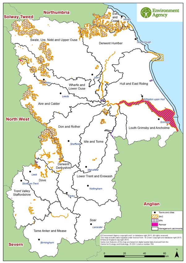
The HRA considers the potential for in-combination effects with other plans and projects.
Given the level of information currently available, the assessment has identified the plans
where the greatest risk of in-combination effects occur, but a detailed assessment can only
be undertaken at the project level when details of location and design of measures are
known. Key external plans to consider for in-combination effects are:
Local Plans – plans of local planning authorities to determine consent for proposed
developments including FCRM ‘Protection’ types of development and which require
HRA for developments affecting European sites
Water Resource Management Plans – plans to manage the supply of water to
communities by Water Companies.
River Basin Management Plans – plans that seek to ensure the objectives of water
dependent European sites are maintained.
Marine Plans – plans to manage the sustainable use of marine resources for inshore
areas.
This HRA does not remove the need for HRA at a subsequent level, i.e. lower tier strategies,
plans or projects that implement measures. This plan-level HRA does not give any weight to
subsequent lower-tier plans or projects and their HRA outcomes.
As local actions are developed at a project level and the details of their scope and scale are
known, this may identify additional effects on European sites that have not been assessed
here, or were not appropriate to consider at this spatial scale of plan.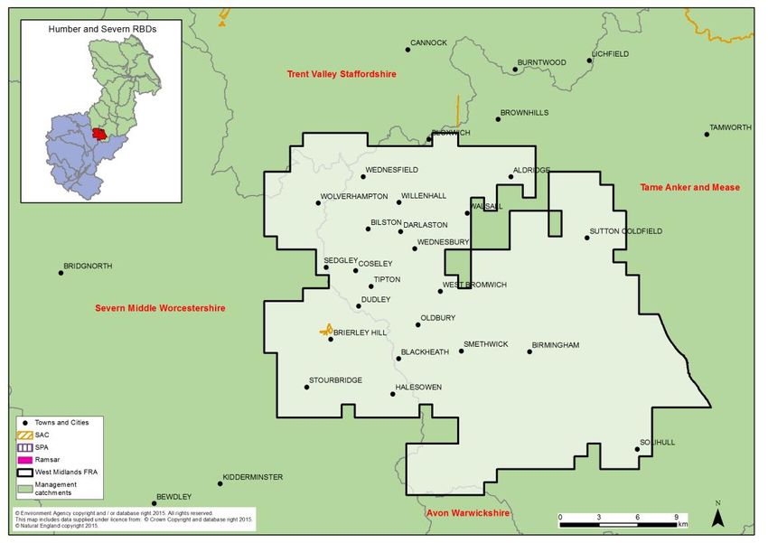
CONTENTS
1     Introduction .................................................................................................................... 7
    1.1    Introducing this report ............................................................................................. 7
    1.2      Background to the FRMPs ...................................................................................... 8
    1.3      The Humber RBD FRMP ........................................................................................ 8
    1.4      Background to Habitats Regulations Assessment ................................................. 11
2     European sites in the Humber RBD ............................................................................. 13
    2.1   European sites that could be affected by the FRMP.............................................. 14
    2.2      European sites and their status for FRMPs ........................................................... 15
    2.3      European sites and their management.................................................................. 16
3     Approach to the HRA ................................................................................................... 17
    3.1   Description of the FRMP programmes of measures .............................................. 17
    3.2      Screening and Likely Significant Effects................................................................ 18
    3.3      Screening out catchments where no European sites are present .......................... 18
    3.4      Screening out measures that would not have physical effects .............................. 18
    3.5      Considering measures from existing plans ............................................................ 19
    3.6      Considering new measures for FRMP cycle 1 ....................................................... 20
    3.7      Considering the need for further stages of assessment ........................................ 20
4     Humber River Basin District Catchments HRA ............................................................. 22
    4.1  Summary of Measures .......................................................................................... 22
    4.2      Screening and Likely Significant Effects................................................................ 24
    4.3      Consideration of results and conclusion ................................................................ 55
5     Kingston-upon-Hull and Haltemprice Flood Risk Area HRA ......................................... 59
    5.1   Summary of Measures .......................................................................................... 59
    5.2      Screening and Likely Significant Effects................................................................ 60
    5.3      Consideration of results and conclusion ................................................................ 61
6     West Midlands Flood Risk Area HRA ........................................................................... 63
    6.1  Summary of measures .......................................................................................... 63
    6.2      Screening and Likely Significant Effects................................................................ 65
    6.3      Consideration of results and conclusion ................................................................ 66
7     Leicester Principal Urban Area Flood Risk Area HRA .................................................. 67
    7.1   Screening and likely significant effects .................................................................. 67
    7.2      Consideration of results and conclusion ................................................................ 68
8     In combination effects with other plans and projects .................................................... 69
    8.1    RBD and FRA FRMPs .......................................................................................... 69
    8.2      In-combination effects between RBD FRMPs ....................................................... 70
    8.3      In-combination effects with external plans ............................................................. 70
9      Conclusion and Future HRAs ....................................................................................... 74
Annex A:   Table A1 - HRA screening table for the FRMP measure categories
           Table A2 - Management catchments and European sites in the Humber RBD
           Table A3 - Mitigation and control measures
Annex B    Humber RBD European sites
1 Introduction
1.1 Introducing this report
This report sets out the results of a strategic-plan level Habitat Regulations Assessment
(HRA) into the likely significant effects on designated ‘European sites’ of the Flood Risk
Management Plan (FRMP) for the Humber River Basin District, published in December
2015. The HRA report has been prepared by the Environment Agency on behalf of the
collective Risk Management Authorities (RMAs) that have responsibilities for information
being published within the FRMP, and are thus the ‘competent authorities’ for the HRA of
their respective published information, as follows:
Information on flooding from main river, sea and reservoirs being published for the
catchments of the river basin district (RBD) are the responsibility of the Environment
Agency (for English catchments).
Information on flooding from local sources being published for any Flood Risk Area
(FRA) is the collective responsibility of Lead Local Flood Authorities within the FRA.
In preparing the HRA report the Environment Agency has consulted with Natural England
(for English catchments) and Natural Resources Wales (for Welsh catchments). The Lead
Local Flood Authorities in Flood Risk Areas are ‘competent authorities’ for HRA of their
FRMP information and have agreed that this report will meet their HRA requirements.
FRMPs are new strategic plans for implementing the Flood Risk Regulations 2009 and the
existing National Flood and Coastal Erosion Risk Management (FCERM) Strategy for
England. They have been developed for River Basin Districts (RBDs) and Flood Risk Areas
(FRAs) and draw together information from a range of existing strategies and plans that are
in place and continue to be maintained by Risk Management Authorities. The HRA has been
carried out at the level of detail published in the FRMP and takes into account HRAs that
have already been undertaken for measures in existing plans, and at the level of detail
provided by these existing plans. Whilst a HRA at this strategic level cannot obtain the level
of detail necessary for in-depth assessment, the HRA summarises the likely risks and
potential need for controls and mitigation and the range of generic mitigation options
available, which will then proceed through further consideration once measures are
developed as specific local actions. In this way, this high- level HRA will be helpful for future
HRAs that consider the effects on European sites at a project level.
The report describes each of the main stages and results of the FRMP HRA as follows:
Describing the network of European sites within the RBD (chapter 2)
The approach to the HRA (chapter 3)
Screening and assessing likely significant effects (chapters 4,5,6,7)
Appropriate assessment, alternative solutions and imperative reasons of overriding
public interest (IROPI) (chapters 4,5,6,7)
Conclusion and future HRAs (chapter 9)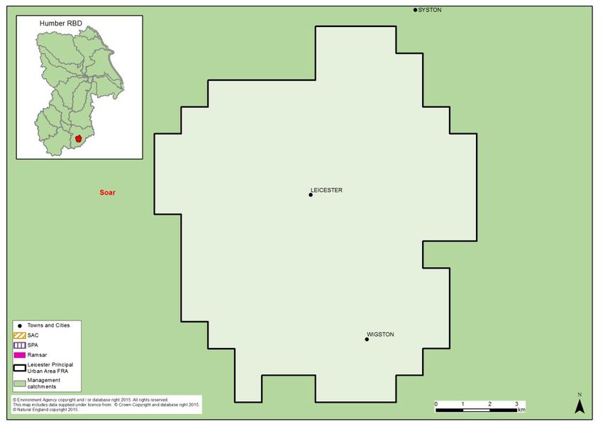
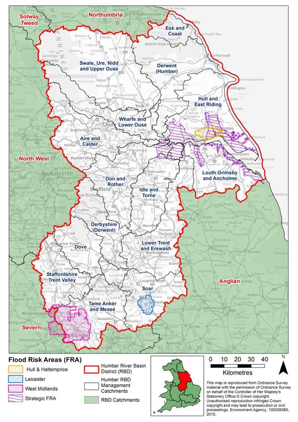
1.2    Background to the FRMPs
Flood risk management plans (FRMPs) highlight the hazards and risks from rivers, the sea,
surface water, groundwater and reservoirs and set out how risk management authorities,
such as the Environment Agency and local authorities, will manage flood risk. They are
required by the European Union Floods Directive and the Flood Risk Regulations 2009. The
FRMPs must be reviewed and reissued every six years to describe progress.

The Environment Agency is required to prepare FRMPs for all of England covering flooding
from main rivers, the sea and reservoirs. Lead Local Flood Authorities (county councils and
unitary authorities) must prepare flood risk management plans for flood risk areas (there are
ten flood risk areas in England) where the risk of flooding from local sources is significant as
identified in Preliminary Flood Risk Assessments.

The 2015-2021 period will be the first cycle of the FRMPs, however RMAs already plan for
flooding and a large proportion of the FRMP measures are taken from existing plans that
have already been consulted on and published. This includes plans such as Catchment
Flood Management Plans (CFMPs) and Shoreline Management Plans (SMPs) as well as
Local Flood Risk Management Strategies that have been developed by local authorities.

Some further strategic developments have been included for the 2015-2021 first cycle of the
FRMP that build on existing plans and seek to address the key objectives of the Flood Risk
Regulations 2009, such as: strengthening joint working of RMAs, developing more integrated
management of the water environment, and updated priorities from any new understanding
of flood risks including the implications of climate change.

1.3    The Humber RBD FRMP
The Humber River Basin District (RBD) covers approximately 26,000km2 from the North
York Moors to Birmingham, the Pennines to the North Sea and Stoke-on-Trent to Rutland.
The Humber RBD ranges from the upland areas of the Peak District, South Pennines and
the North York Moors with their internationally important peatlands, across the Derbyshire
and Yorkshire Dales and the fertile river valleys of the Trent and Ouse, to the free-draining
chalk of the Yorkshire and Lincolnshire Wolds. Watercourses range from heavily modified to
pristine natural chalk rivers.

The landscape includes steep sided valleys and rural communities along with large,
historical industrial urban areas. Around 11.7 million people live and work within the Humber
RBD. The population is split between the large urban conurbations of the great cities of the
midlands and the north east, and small communities within very rural areas. The river basin
district is predominantly rural, with more than 60% of its land used for agriculture. The
Humber RBD comprises fifteen management catchments (see map in Figure 1).

The Humber RBD is one of the most diverse regions in England and this is therefore
reflected in the varied flood response. These range from the rapidly responding catchments
in the West Pennines, pumped catchments in East Yorkshire and Lincolnshire and tidal
flooding in the Humber, Ouse and Trent.

The most recent widespread flooding was the tidal flooding experienced in December 2013.
Land along the east coast flooded from the sea overtopping the tidal defences. On the 5th
December 2013 many communities along the coast flooded, including Winteringham, South
Ferriby, Barton Upon Humber, Immingham, Grimsby, Cleethorpes Hull and surrounding
villages, Whitby and Scarborough. The tidal surge was the largest recorded along this coast.

Figure 1 Humber RBD catchments and Flood Risk Areas
The FRMP describes the scale of flood risk in the Humber RBD which includes:
Of the almost 12 million people who live within the Humber RBD, on average 9% are
at risk from flooding from rivers or the sea. However in some of the district’s
management catchments, for example the Hull and East Riding catchment and the
Louth, Grimsby and Ancholme catchment, this risk is much greater affecting 57% and
32% of the respective populations, due to the low lying nature of much of the land
and associated towns and villages, and their proximity to the coast and/or Humber
Estuary.
16% of all agricultural land in the Humber RBD is at risk of flooding from rivers and
the sea.
34% of Environmental Permitting Regulation sites, which include heavy
manufacturing industry, intensive agriculture, waste and landfill sites, and aggregate
industries, are at risk from river and sea flooding.
12% of services (including schools and hospitals) and 26% of roads within the
Humber RBD are at risk from surface water flooding.
There are other sources of flooding that affect the Humber RBD, such as ground
water flooding and sewer flooding. The Environment Agency does not have national
scale modelling and mapping for these sources of flooding, and so it is not possible
to draw conclusions about the risks in this FRMP.
The coastline of the Humber RBD is among the most susceptible in England to
coastal erosion and sediment movement with the North and East Yorkshire coasts
amongst the fastest eroding coastlines in Europe.
The Humber RBD FRMP sets out the objectives and measures that have been drawn by risk
management authorities from existing plans or newly developed for the FRMP cycle period
of 2015-2021. Existing measures in the Humber RBD FRMP are derived from the following
source plans:
The Tyne to Flamborough Head and Flamborough Head to Gibraltar Point Shoreline
Management Plans (SMPs)
Catchment Flood Management Plans (CFMPs)
Local Flood Risk Management Strategies (FRMS) developed by LLFAs.
The FRMP is divided into the separate plans that are the responsibility of different risk
management authorities, as follows:
Measures within the 15 RBD catchments of the Humber RBD that the Environment
Agency is responsible for,
Measures within the Kingston-upon-Hull and Haltemprice FRA for local sources of
flooding that Kingston-upon-Hull City Council as the Lead Local Flood Authority are
responsible for. This FRA covers part of the Hull and East Riding management
catchment.
Measures within the West Midlands FRA for local sources of flooding that the Lead
Local Flood Authorities are responsible for. There are several local authorities within
this FRA but the majority of it is covered by Birmingham City Council. This FRAcovers part of the Tame Anker and Mease and Staffordshire Trent Valley
management catchments.2
Measures within the Leicester Principal Urban Area FRA for local sources of flooding
that Leicester City Council as the Lead Local Flood Authority are responsible for.
This FRA covers part of the Soar management catchment.
1.4 Background to Habitats Regulations Assessment
In England, the Conservation of Habitats and Species Regulations 2010, as amended,
commonly termed the Habitats Regulations, implements the European Union Habitats
Directive (Directive (92/43/EEC) on the Conservation of natural habitats and of wild flora and
fauna, and certain elements of the Wild Birds Directive (2009/147/EC). This legislation
provides the legal framework for the protection of habitats and species of European
importance in England.
Sites protected under the Habitats Regulations comprise Special Protection Areas (SPA),
Special Areas of Conservation (SAC), candidate SACs (cSAC), Sites of Community
Importance (SCI) and, as a matter of government policy, to potential Special Protection
Areas (pSPA) and Ramsar sites (sites designated under the 1971 Ramsar Convention for
their internationally important wetlands). These sites are referred to collectively as in this
report as ‘European sites’.
Regulation 9(3) of the Habitats Regulations requires that a ‘competent authority’ must
consider the requirements of Habitats Directive in exercising any of its functions. Article 6(3)
of the Habitats Directive defines the requirements for assessment of plans and projects
potentially affecting European sites. This requires that a competent authority, before
deciding to undertake, or give any consent or authorisation for a plan or project which is
likely to have a significant effect on a European site, and is not directly connected with or
necessary to the management of that site, must carry out an appropriate assessment. The
term commonly referred to for the assessment process is ‘Habitats Regulations
Assessment’.
The Humber FRMP is considered to fit within the definitions of a ‘plan’ as defined by the
Habitats Directive, and requires a Habitats Regulations Assessment (HRA). The FRMP is a
high-level planning document for the Humber River Basin District (RBD) (see map in Figure
1), therefore potential impacts of the plan on European sites across the RBD are difficult to
determine. Given the geographic scale and nature of the plan, the HRA has been tailored to
be appropriate for the spatial area of coverage and the strategic nature of the plan.
The Habitats Regulations Assessment has followed a framework of four distinct stages, only
moving to the next stage if required by the results of that stage of the assessment. The four
stages are:
Stage 1: Screening and Likely Significant Effects is the process which initially identifies
the likely impacts upon a European Site of a plan or project, either alone or in combination
with other plans or projects, and considers whether these impacts may be significant. This
stage also includes the development of mitigation to avoid or reduce any possible effects.
2
The West Midlands FRA also covers part of the Avon Warwickshire and Severn Middle
Worcestershire management catchments within the Severn RBD. Measures for those management
catchments will be assessed in the Severn FRMP HRA.Stage 2: Appropriate Assessment is the detailed consideration of the impact on the integrity of the European Site of the plan or project, either alone or in combination with other plans or projects, with respect to the site’s conservation objectives and its structure and function. This is to determine whether there is objective evidence that adverse effects on the integrity of the site can be excluded. This stage also includes the development of mitigation to avoid or reduce any possible effects. Stage 3: Assessment of alternative solutions is the process which examines alternative ways of achieving the objectives of the plan or project that would avoid adverse impacts on the integrity of the European Site, should avoidance or mitigation be unable to avoid adverse effects. Stage 4: Assessment where no alternative solutions exist and where adverse effects remain is made with regard to whether or not the plan or project is necessary for imperative reasons of overriding public interest (IROPI) and, if so, of any required compensatory measures.
2 European sites in the Humber RBD
Within the Humber RBD there are 45 European sites. There are 31 SACs, 9 SPAs, and 5
Ramsar sites. Two sites, Humber Estuary and Lower Derwent Valley, are designated as
SAC, SPA and Ramsar across their site areas. There are also 2 sites, North Pennine Moors
and North York Moors, which have both SAC and SPA designation. Figure 2 shows the
European sites present and the management catchments of the Humber RBD.

Thirty three of the European sites are also designated as a WFD Protected Area (26 water
dependent SACs and 7 water dependent SPAs).

Figure 2 - Map of the European sites in the Humber River Basin District
Although most of the European sites contain a variety of habitat types, broadly speaking they
could be described as coastal and marine sites, freshwater sites comprising rivers, lakes,
canals and other wetlands and terrestrial sites such as woodlands, grasslands and
moorlands.

The 31 SAC sites in the management catchment are many and varied, and range from
calaminarian grassland sites such as Ox Close, mesophile grassland such as Ensor’s Pool
in Warwickshire; and numerous freshwater sites including Cannock Chase Extension Canal
in the Midlands and the River Derwent in East Yorkshire.

The 9 SPA’s in the RBD include 2 estuarine/coastal sites – the Humber Estuary and
Flamborough Head and Bempton Cliffs on the east coast of the RBD. The remaining sites
are generally moorland sites such as the North and South Pennine Moors and North York
Moors, and lowland freshwater sites such as the Derwent Valley and Hornsea Mere, both in
East Yorkshire.

Of the 5 Ramsar wetlands, 4 are freshwater with the other being the Humber Estuary which
is coastal/estuarine. Lower Derwent Valley and Midland Meres and Mosses are lowland
freshwater sites whilst Malham Tarn is the only upland site, north of Skipton in the west of
the RBD.

The size of European sites within the Humber RBD range in scale. Smaller sites include
Ensor’s Pool at 3.8Ha and Bees Nest and Green Clay pits at 14Ha, to the Humber Estuary
and the North York Moors at 36,000Ha and 44,000Ha respectively.

As can be seen in Figure 2, most of the European sites flank the west, north and east
perimeters of the RBD. There are relatively few sites to the centre of the RBD, or to the
south. These areas are where population centres such as Birmingham, Leicester,
Nottingham and Doncaster are located.

Annex B contains a summary of the European sites present within the Humber RBD. Table
A2 in Annex A presents a summary of the European sites present within the management
catchments of the Humber RBD. In a number of cases European sites cross over the
boundary of two or more management catchments, therefore a number of European site
names/designations may appear against more than one management catchment.

2.1    European sites that could be affected by the FRMP
The Humber FRMP is a long term plan for the water environment, which could potentially
affect both water dependent and non water-dependent European sites and their qualifying
features.

It is not possible from the outset to rule out, at the RBD scale, any (water-dependent or non
water-dependent) European sites from being affected by the Humber FRMP. The HRA (in
particular Section 4.2 and 5.2 / 6.2 / 7.2 for the 3 FRAs) reviews the European sites by
management catchment, and determines whether any of the measures within the
catchments are likely to lead to significant effects on European sites.
2.2    European sites and their status for FRMPs
Some European site interest features (habitats and species) are considered as water-
dependent for the purposes of the WFD. This means those European sites with one or more
water-dependent feature are included on the register of protected areas, as required by
Article 6 of the WFD.

The Humber RBMP provides summary information on the current status and baseline for
water dependent European sites as part of its monitoring data.

European sites in England, with the occasional exception, are also designated as SSSIs.
SSSI component units underpin the European sites and Natural England only collect data at
the SSSI unit level.

Natural England monitors the condition of SSSIs using six reportable condition categories:
favourable; unfavourable recovering; unfavourable no change; unfavourable declining; part
destroyed and destroyed. When SSSI units are in favourable condition, they are deemed to
be meeting their conservation objectives.

Table 1 gives the current condition status of water-dependent SSSI units in the Humber RBD
which are also WFD protected areas, as currently recorded on Natural England’s designated
site data system.

Table 1 Status of water-dependent European sites in the Humber RBD based on
assessment of their component SSSI units (Extract from Natural England databases
August 2015)

from Condition               Humber RBD (ha)
Favourable                         18,167
Destroyed / Part destroyed            -
Unfavourable declining              524
Unfavourable no change             2,803
Unfavourable recovering            95,637
Total Area Unfavourable            98,964
% Unfavourable                       84

This shows that for the Humber RBD, a large proportion (84%) of water-dependent SSSI
units of European sites are currently not compliant with the condition requirements. This is
higher than all of the other RBDs.

The pressures on such sites in the Humber RBD vary between sites. Many of the
moorland/upland sites, such as the South Pennine Moors, North York Moors and Peak
District Dales have pressures relating to the fact they are large areas and provide a
recreational resource for areas with higher population densities such as Bradford, Sheffield
and York. These sites list vandalism, public access and third party development as
pressures. They all also cite changes in hydrological regimes and species distribution which
may be more related to the changing climate and national pressures on biodiversity.
The linear riverine sites such as the River Derwent and River Mease SACs cite water
pollution and changes in land management as pressures, with the Mease also listing siltation
and dams and weirs.
Almost all sites list invasive plants as a pressure, with many of the larger sites also citing
disease as a threat which may also be reflective of the changing climate and national
pressures on biodiversity.
2.3 European sites and their management
As part of a new strategic approach to managing all England’s European sites, new
measures needed to achieve favourable conservation status for all European sites in
England have been developed by Natural England. These are collectively referred to as Site
Improvement Plans (SIPs), and are being developed by the Improvement Programme for
England’s Natura 2000 sites (IPENS). SIPs were published for all European sites in England
in 20153.
The Humber FRMP recognises SIPs include actions where flood risk management is
specifically a mechanism for their delivery. The following are the relevant SIPs for Humber
RBD:
Site Improvement Plan: Humber Estuary (SIP108)
Site Improvement Plan: Lower Derwent Valley (SIP058)
Site Improvement Plan: Peak District Dales (SIP168)
Site Improvement Plan: River Derwent (SIP195)
Site Improvement Plan: River Mease (SIP196)
Site Improvement Plan: Thorne and Hatfield Moors (SIP246).
3
Site Improvement Plans for the Humber River Basin District can be found on:
http://publications.naturalengland.org.uk/category/62871977831956483 Approach to the HRA
The steps undertaken to complete the HRA are as follows:
describe the plan and the measures proposed
screen and assess the likely significance of any effects on European sites
consider need for further stages of assessment (i.e. appropriate assessment,
alternative solutions and IROPI)
determine a plan level conclusion
3.1 Description of the FRMP programmes of measures
The Humber River Basin District Flood Risk Management Plan (FRMP) is a joint publication
of several plans required under the Flood Risk Regulations that are the separate
responsibilities of specific Risk Management Authorities (RMAs), as follows:
Humber River Basin District catchments (Environment Agency)
Kingston-upon-Hull and Haltemprice Flood Risk Area (LLFAs within the FRA)
West Midlands Flood Risk Area (LLFAs within the FRA)
Leicester Principal Urban Area Flood Risk Area (LLFAs within the FRA).
3.1.1 River Basin District Catchments
FRMPs for the River Basin District (RBD) are being published by the Environment Agency
(for English catchments) and Natural Resources Wales (NRW) (for Welsh catchments), and
are focused on measures principally to address flood sources from main river, the sea and
reservoirs. The measures have been divided into catchments based on the River Basin
Management Plans (where they are called ‘management catchments’).
Production of the FRMPs for the RBDs is the legal duty of the Environment Agency and
NRW. Where any voluntary information on local sources of flooding within RBD catchments
has been provided by LLFAs, these are published by joint agreement in the RBD FRMP. The
Environment Agency and NRW are also the competent authority under the Habitats
Regulations for the RBD FRMPs.
3.1.2 Flood Risk Areas
FRMPs for Flood Risk Areas (FRAs) are being published by the Lead Local Flood
Authorities (LLFAs) where the FRAs lie within their administrative boundaries. Production of
the FRMPs for the FRAs are the legal duty of the respective LLFAs. The LLFAs responsible
for the FRA FRMPs are also the competent authority under the Habitats Regulations.
Where a RBD includes one or more FRA, as is the case for the Humber RBD, the measures
that have been developed specifically for these FRA FRMPs are presented and assessed
separately.
3.1.3 Applying HRA
In applying the HRA process, each RMA plan has been assessed separately. A final
summary of conclusions and recommendations for future HRAs is provided that also draws
on a high-level summary of the potential for in-combination effects of the FRMP with other
key plans.3.2 Screening and Likely Significant Effects
This first stage of the HRA process requires consideration of screening and likely significant
effects of measures on European sites. The tasks undertaken to complete this are as
follows, and set out in more detail below:
screening out catchments where no European sites are present
screening out measures that would not have physical effects
considering measures from existing plans, with mitigation / controls already agreed in
HRAs for any likely significant effects, or in some cases potential adverse effect on
site integrity
considering new measures and their likely significant effects, with mitigation / controls
where considered necessary
conclusion from screening and likely significant effects.
The results of these tasks for each RMA’s plan of the FRMP are provided in the following
chapters:
Chapter 4: Humber River Basin District catchments
Chapter 5: Kingston-upon-Hull and Haltemprice Flood Risk Area
Chapter 6: West Midlands Flood Risk Area
Chapter 7: Leicester Principal Urban Area Flood Risk Area.
3.3 Screening out catchments where no European sites are present
Where there are no European sites present in a catchment, it was determined that no further
consideration of measures in the catchment is required. Given the level of detail in the plan
where the FRMP measures are mainly strategic in nature and are not specific on their
precise location, there is insufficient details to consider downstream or down drift effects
beyond the catchment. However, such screening for cross-catchment effects will be a
requirement in assessing local plans and projects.
3.4 Screening out measures that would not have physical effects
Every measure included within the FRMP is categorised according to one of the following 5
categories, accompanied by an M-code:
Prevention (M2) - reducing the impacts of flooding through land use and
development policy, relocation of assets at risk, or measures to divert the hazard to
avoid harm.
Protection (M3) - protecting people from the risk of flooding; for example, by the
maintenance, refurbishment of existing defences or building new defences.
Preparedness (M4) - by taking actions that prepare people for flooding; for example,
by improving awareness of flood risk, or by providing warning and forecasting for
floods. Recovery and review (M5) - supporting recovery after flooding has happened and
reviewing how things can be improved; for example, by improving the availability of
recovery services such as providing temporary accommodation.
Other (M6) – measures not fitting in to any of the above categories.
Further definitions of each of the measures are set out in the FRMP according to a second
tier of M-codes. For example, Prevention (M2) includes the second tier measure, M22, which
is defined as “Prevention, removal or relocation measure to remove receptors from flood
prone areas or to relocate receptors to areas of lower risk”. These measure definitions have
been used as the basis for the initial screening out of the measures that require no for further
consideration within the HRA.
The measure codes and their definitions are included as Table A1 (in Annex A to this
document). Measures under ‘Preparedness’ (M4) and ‘Recovery and review’ (M5) will not
result in development, demolition or changes of management ‘on the ground’ that could
result in effects on European sites. These were therefore screened out from any further
consideration. Similarly, under the ‘Prevention’ category (M2), only the removal or relocation
of receptors from flood prone areas could potentially affect European sites. The measures
that have been screened in to the assessment are set out below and have been highlighted
in Table A1:
M22 – Prevention – removal or relocation (category)
M3 – Protection – all sub-categories
M6 – Other – not yet defined.
3.5 Considering measures from existing plans
Risk Management Authorities have a range of plans in place for developing and
implementing measures related to flooding from main river (in Catchment Flood
Management Plans), to flooding from the sea (in Shoreline Management Plans) and related
to local sources of flooding (e.g. in Local Flood Risk Management Strategies). These plans
have been subject to HRA where relevant, and have reported on the effects on European
sites consistent with the level of detail of the plans.
For this HRA, these existing HRAs have been used to summarise the effects of measures
from existing plans that are now set out under specific RBD catchments or FRAs. For many
RBD catchments and FRAs there are multiple existing plans covering the geographic area
but also some existing plans that are split across RBD catchments or FRAs. Nonetheless we
have separated out the ‘screened in’ measures from individual existing plans and referenced
the specific HRA results that apply to them.
The results from existing HRAs have considered the extent that they remain valid since they
were published. This has been done by checking the status of the relevant European sites
that were considered within the source plan’s HRA for any changes to site designations
since the date of the HRA publication. The criteria were agreed with Natural England and
comprised: whether there were any new / additional site designations, any changes in site
boundaries, changes in designated site features, or any significant changes in site
conditions.The HRA results from Shoreline Management Plans are relatively recent with most
published between 2010 and 2011. The HRA results from Catchment Flood Management
Plans are a little older with most published between 2008 and 2010. The HRA results from
Local Flood Risk Management Strategies are the most recent with the first ones being
published around 2012 and most being published much more recently.
One of the main reasons for a likely change from when the effects of plan measures were
reported in HRAs is where there have been boundary changes to European sites or to the
scope of condition of the interest features of the sites i.e. specific habitats, species etc.
Where we have been advised that such changes have occurred and are significant then this
has triggered further consideration of the validity of the existing HRA results that we have
relied upon.
3.6 Considering new measures for FRMP cycle 1
In reviewing the range of measures across existing plans covering all sources of flooding,
Risk Management Authorities (RMAs) have taken the opportunity to put forward further
strategic developments for the next 6 year cycle of the FRMP. These ‘new measures’ focus
on: strengthening the joint working of RMAs across all flood sources; developing more
integrated management of the water environment as set out in the River Basin Management
Plans and other related plans; and updating flood risk information to help manage risks with
communities.
For this HRA we have reviewed the set of new measures that have been ‘screened in’ for
each catchment. As they are mostly ‘strategic’ measures without specific information on
location or the form of action that would be developed on the ground, we have considered a
range of factors that would give rise to any likely risks from this set of measures in a specific
catchment, which includes:
their general proximity in the catchment to European sites
whether they aim to address sources of flooding that are local, or main river or
related to the coast
the mix of types of new measures within the catchment denoted by their M-codes
(i.e. whether they are mainly maintenance, or channel works, or new solutions).
General proximity was considered by narrowing down the set of measures within a
catchment to those that were closer in general and more likely to be connected to European
sites by the hydrology of the catchment rather than applying specific buffer distances to
individual measures.
3.7 Considering the need for further stages of assessment
HRA steps were carried out for each RBD catchment of the RBD plan that is the
responsibility of the Environment Agency. Further HRA steps were carried out for each FRA
(by catchment) that is the responsibility of respective Lead Local Flood Authorities. The
determination for each catchment or FRA that there are no likely significant effects to
European sites, is based on the following assumptions:
that this HRA does not remove the need for HRA at a subsequent level, i.e. lower tier
strategies, plans or projects that implement measures, nor does it give any weight totheir outcomes. Consideration of potential impacts and options available to mitigate
for those impacts should assist, but not influence or constrain any lower-tier
assessments.
that as local actions are developed at a project level and the details of their scope
and scale are known, that this may identify additional effects on European sites that
have not been assessed here, or were not appropriate to consider at this spatial
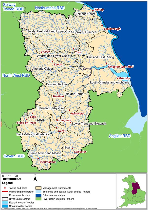
scale of plan.4 Humber River Basin District Catchments HRA This chapter sets out the results of carrying out the HRA on the measures for the Humber RBD catchments that are for flooding from main river, sea and reservoirs and for local flooding sources outside of Flood Risk Areas. This is the FRMP information for which the Environment Agency is the FRMP ‘statutory authority’ and HRA ‘competent authority’. The Flood Risk Area FRMP information for which other RMAs have responsibility has been considered separately in later chapters of the HRA (see sections 5, 6 and 7). This section covers the following stages of the assessment: Summary of measures being assessed Screening and assessment of likely significant effects Consideration of results and conclusion 4.1 Summary of Measures The initial screening and assessment of likely significant effects reviewed the measures for each of the 15 management catchments within the Humber FRMP (see figure 3). Figure 3 - Map of the Humber River Basin District and management catchments
A summary of the measures and their screening for each catchment is given in Table 2.
Table 2: Summary of measures by catchment
screened in (out)
Management Number of measures related Number of new measures
Number of new
European sites
measures from
1
existing plans
measures for
management
1 1
Catchment to types of existing plans and known level of detail
catchment
Number of
Number of
Number of
1
present in
measures
cycle one
Catchments with no European sites present
0
Soar No screened in measures as no European sites present 0
(21)
Catchments with no screened in measures
All remaining catchments have some screened in measures
Catchments with all measures from existing plans
All remaining catchments have new measures
Sub-total 0 (21) 0 0
% all measures 0% 0%
Catchments with new measures for cycle 1 of the FRMP
Humber RBD 8 0 8 0 not in proximity n/a
Wide (12) 8 strategic/proximity unknown
0 specific/in proximity
Aire and 47 5 3 from LLFA plans 42 27 not in proximity 9
Calder (85) 2 from CFMP 1 strategic/proximity unknown
14 specific/in proximity
Derwent 11 4 4 from CFMPs 7 7 not in proximity 4
Derbyshire (11) 0 strategic/proximity unknown
0 specific/in proximity
Derwent 34 20 1 from SMPs 14 0 not in proximity 11
Humber (77) 19 from LLFA plans 6 strategic/proximity unknown
8 specific/in proximity
Don and 54 2 2 from LLFA plans 52 50 not in proximity 7
Rother (46) 0 strategic/proximity unknown
2 specific/in proximity
Dove 11 3 3 from LLFA plans 8 1 not in proximity 4
(25) 7 strategic/proximity unknown
0 specific/in proximity
Esk and 42 41 2 from SMPs/other EA plans 0 0 not in proximity 5
Coast (37) 39 from LLFA plans 0 strategic/proximity unknown
0 specific/in proximity
Hull and East 14 2 2 from LLFA plans 12 10 not in proximity 7
Riding (22) 0 strategic/proximity unknown
2 specific/in proximity
Idle and Torne 6 5 5 from CFMPs 1 0 not in proximity 6
(11) 0 strategic/proximity unknown
1 specific/in proximity
Louth 19 2 2 from CFMPs 17 15 not in proximity 3
Grimsby and (44) 1 strategic/proximity unknown
Ancholme 1 specific/in proximity
Lower Trent 13 11 5 from CFMPs 2 1 not in proximity 3
and Erewash (19) 6 from LLFA plans 1 strategic/proximity unknown
0 specific/in proximity
Swale, Ure, 25 12 6 from CFMPs 13 7 not in proximity 8
Nidd and (48) 6 from LLFA plans 2 strategic/proximity unknown
Upper Ouse 4 specific/in proximity
Tame Anker 19 3 3 from LLFA plans 16 13 not in proximity 3
and Mease (59) 1 strategic/proximity unknown
2 specific/in proximity
Staffordshire 28 19 9 from CFMPs 9 0 not in proximity 7
Trent Valley (117) 10 from LLFA plans 9 strategic/proximity unknown
0 specific/in proximityWharfe and 21 6 6 from LLFA plans 15 14 not in proximity 8
Lower Ouse (41) 0 strategic/proximity unknown
1 specific/in proximity
Sub-total 362 135 33 from CFMPs 216 145 not in proximity
(644) 2 from SMPs/other EA plans 36 strategic/proximity unknown
100 from LLFA plans 35specific/in proximity
% all 35% 13% 21% 145(14%) 36(4%) 35 (3%)
2
measures
Overall Total 362 135 33 from CFMPs 216 see above
(665) 2 from SMPs/other EA plans
100 from LLFA plans
% all 42% 12%313(3%) 2(measures, which forms the basis for how each management catchment has been assessed.
The following sub-sections consider each of the management catchments in turn.
Table 3: Management Catchments of the Humber RBD/FRMP
Management Catchment Management Catchments
Category
Management catchments with no Soar
European sites present.
Management catchments with no None
‘screened in’ measures.
Management catchments with all None
measures from existing plans.
Management catchments with Aire and Calder Derwent Derbyshire
new measures. Derwent Humber Don and Rother
Dove Esk and Coast
Hull and East Riding Idle and Torne
Louth, Grimsby and Ancholme Lower Trent and Erewash
Swale, Ure, Nidd and Upper Tame Anker and Mease
Ouse
Staffordshire Trent Valley Wharf and Lower Ouse
4.2.1 Management catchments with no European sites present
There is one management catchment within the Humber RBD with no European sites
present.
4.2.1.1 Soar Management Catchment
European sites New measures Existing plan measures
Screened in Screened out Screened in Screened out
0
1 9 5 6
The Soar management catchment contains no European sites and therefore its measures
have been screened out of further consideration on this basis.
4.2.2 Management Catchments with no ‘screened in’ measures
All management catchments within the Humber RBD have screened in measures, therefore
no management catchments have been ruled out of further consideration on this basis.
4.2.3 Management Catchments with all measures from existing plans
There are no management catchments within the Humber RBD with only measures from
existing plans, therefore no management catchments have been ruled out of further
consideration on this basis.4.2.4 Management Catchments with New Measures
4.2.4.1 Humber River Basin District
European sites New measures Existing plan measures
Screened in Screened out Screened in Screened out
45
8 12 0 0
Within the Humber RBD there are 45 European designated sites, 31 SACs, 9 SPAs, and 5
Ramsar sites. More details of the sites present can be found in section 2 of this report.
New measures
In total there are 20 new measures in the FRMP that will be applied across the whole of the
Humber RBD. Twelve of them are screened out of this assessment as they relate to flood
prevention and recovery, through mapping and modelling and data collection, and flood
preparedness such as improving flood forecasting and warning, increasing public awareness
and emergency response planning. One measure is to have on-site reservoir plans in place
for all Environment Agency high risk reservoirs.
The 8 new measures in the FRMP which are screened into this assessment all relate to
flood protection.
There is 1 water flow regulation measure (M32) in relation to high risk reservoir regulation
under the Reservoirs Act 1975 which does not involve physical works so will not impact upon
European sites.
There are 5 other protection measures (M35) which are all strategic and do not involve direct
works on the ground. The measures mainly relate to ways of working and improving
efficiency but there is one to produce opportunity mapping for working with natural
processes.
There is 1 new measure involving channel, coastal and floodplain works (M33). This does
not involve on the ground works nor relate to specific locations but is a more general
strategic approach to flood risk management asset maintenance.
There is 1 new measure relating to natural flood management (M31) being applied across all
Humber RBD management catchments in relation to opportunities to reducing local flood risk
and delivering WFD outcomes through habitat creation/restoration, re-naturalising
watercourses and working with natural processes. This measure will enhance the
biodiversity value of areas where it is applied. As the locations are yet to be determined it is
not known whether they will be within or near a European site. Potential risks to designated
site from such measures would include habitat changes as a result of woodland planting and
land management changes, or loss of freshwater habitat as a result of realignment of banks
to reinstate natural floodplains.
Given the general scope and the strategic scale of the measures, the FRMP does not
specify or constrain how or where measures are implemented. The measures will be subject
to project level control through the relevant consenting process and the associated
requirement for the consideration of project level HRA and for appropriate mitigation. At thisstrategic plan level, a range of mitigation options have been identified (see section 4.3.3 and
also Table A3 in Annex A).
Given the avoidance and mitigation options available to ensure adequate project-level
controls are in place, the strategic plan-level measures are screened as not likely to
lead to significant effect on the European sites. This is a plan-level conclusion and does
not remove the need for lower-tier HRA, nor does it influence the conclusions or specific
need for appropriate assessment to investigate mitigation options in more detail.
Existing plan measures
There are no existing plan measures across the Humber RBD.
4.2.4.2 Aire and Calder Management Catchment
European sites New measures Existing plan measures
Screened in Screened out Screened in Screened out
9
42 36 5 49
The Aire and Calder management catchment contains 9 European sites. This comprises, 5
SACs, 3 SPAs and one Ramsar site. The majority of these lie to the west of the Aire and
Calder management catchment, comprising, the North and South Pennine Moors (SAC &
SPA), the Peak District Moors (SPA) and the Craven Limestone Complex (SAC) which cover
a significant area of the upland areas to the north and west of the management catchment.
These sites are designated for a number of habitats including heathland, dry grassland and
raised bog and support important population of birds such as curlew, snipe and peregrine.
The Denby Grange Colliery Pond (SAC), designated for its population of great crested newts
is near Wakefield, which is further south and east, and Malham Tarn (Ramsar) is to the
north.
New measures
There are 78 new FRMP measures in the Aire and Calder management catchment with 36
of them screened out of this assessment. These are measures to complete feasibility studies
and carry out model reviews and do not involve any physical works.
Of the 42 screened in measures, the majority of them will not have any impact on European
sites by virtue of their location. These measures appear in urban centres such as
Huddersfield and Leeds, which do not contain any European sites.
There are a number of new measures for the Upper Aire catchment in areas such as
Todmorden, Hebden Bridge and Mytholmroyd. These areas are much closer (as little as
0.5km) to the South Pennine Moors SAC and SPA, however the measures are works to
assets (or proposed new assets) within the populated areas in the valley bottom, outside of
the designated sites and as such impacts to these sites will be avoided.
Of these new measures, the only one with the potential to impact on designated sites is
Mythomroyd flood alleviation scheme. This could potentially have impacts on the South
Pennine Moors SAC and SPA if upland management/natural flood management was taken
forward as an option. However this would likely be in conjunction with other interventions
that are more localised. If this was taken forward, the associated land use changes mayimpact on the South Pennine Moors European site through issues such as changes in habitat balance, changes to hydraulic regimes and disturbance of bird species such as golden plover and merlin. This would be mitigated by careful management and design of such features and timing of works. No options would be implemented if they were thought to have potential for impacts on interest features of these sites. It may also be possible to improve some features of these sites through careful design of interventions. At this strategic plan level, a range of mitigation options have been identified (see section 4.3.3 and also Table A3 in Annex A). Given the avoidance and mitigation options available to ensure adequate project-level controls are in place, the strategic plan-level measures are screened as not likely to lead to significant effect on the European sites. This is a plan- level conclusion and does not remove the need for lower-tier HRA, nor does it influence the conclusions or specific need for appropriate assessment to investigate mitigation options in more detail. Existing plan measures – River Hull and Coastal Streams CFMP There is 1 measure from the River Hull and Coastal Streams CFMP (2010) which is screened out of this assessment. It is an M24 measure relating to modelling and strategic partnership working in managing flood risk across the Humber catchment. As the measure does not involve physical works, there will be no impacts upon European sites. Existing plan measures - Kirklees Flood Risk Management Strategy There are 32 measures from the Kirklees Flood Risk Management Strategy. Twenty nine of the measures relate to investigations with no physical works or policy measures (M2 – Protection). These have been screened out of further assessment. Of the 3 screened in measures, 1 is to implement a maintenance regime based on risk. Maintenance works have the potential to impact on European sites where assets are located next to or within them. Impacts could occur via physical disturbance to habitats and species. As the location and scope of work is not yet set out, there is sufficient opportunity to ensure that any impacts can be managed out at project level via scheme level HRA. There are 2 measures related to potential capital works. These are to work with significant landowners to employ land management techniques which reduce the rate of surface water runoff, and to develop a programme of schemes to be funded through local levy. These measures have the potential to impact on European sites through direct disturbance to habitats and species, and indirectly through hydrological changes which may then affect vegetation communities and sediment balance. As these measures are not fixed in terms of location and scope, it is considered that any impacts on European sites can be managed by ensuring schemes are designed to avoid impacts, completion of project level HRA where necessary and specific mitigation such as timing and location of works. With this mitigation applied these measures are not likely to lead to significant effect on European sites. Existing plan measures - Calderdale Flood Risk Management Strategy There is 1 new measure to carry out further investigations into groundwater, surface water and ordinary watercourse flood risk. As this measure is for investigations and does not involve on the ground works this measure is screened out.
You can also read