Milton Keynes Council Plan:MK Schedule of Proposed Additional Modifications (October 2018)
←
→
Page content transcription
If your browser does not render page correctly, please read the page content below
Plan:MK Schedule of Proposed Additional Modifications – October 2018

                                                       Milton Keynes Council

                                                                       Plan:MK

Schedule of Proposed Additional Modifications
               (October 2018)

                                                                          1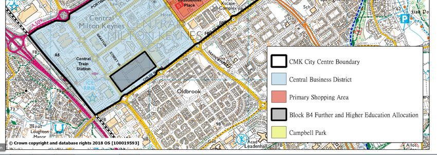
Plan:MK Schedule of Proposed Additional Modifications – October 2018
Ref Pag Policy Para/Table/ Proposed modification Reason for
e Figure/Bullet Deletions proposed
No. Additions modification
AddM1 3 Paras 1.5 Include the Site Allocations Plan as one of the documents that comprise the statutory Development Plan for the Borough. (NB The list will Factual update
and 1.6 require updating again on the adoption of Plan:MK.) following the
receipt of the
Inspector’s report
on the
examination of the
Site Allocations
Plan.
AddM2 3 Para 1.8 In addition, there are a number of made (adopted) neighbourhood plans in Milton Keynes. They cover: To reflect the
• Woburn Sands (2014) latest status of
• Lakes Estate (2015) Neighbourhood
• Central Milton Keynes (Business Neighbourhood Plan) (2015) Plans in Milton
• Wolverton Town Centre (2015) Keynes.
• Great Linford North (2016)
• Great Linford South (2016)
• Newport Pagnell (2016)
• Walton (2017)
• Olney (2017)
• Castlethorpe (2017) [to be approved]
• Sherington (2017) [to be approved]
• Woughton (2018)
• Stony Stratford (2018)
• Campbell Park (2018)
• West Bletchley (2019) [to be approved]
AddM3 3 Para 1.9 A number of other neighbourhood plans are in preparation. The Neighbourhood Plan Designation designates which parishes are To ensure
currently involved in the neighbourhood planning process and the stage they are at. Plan:MK
consistently
reflects the latest
position of
Neighbourhood
Plans
AddM4 3 Para 1.10 Neighbourhood plans provide detailed policies for the local areas that they cover and complement the strategic policies elsewhere in the To ensure
Development Plan. Appendix J will provide a list of strategic policies which should be considered when preparing a neighbourhood Plan:MK provides
plan. Several of the made and emerging neighbourhood plans allocate sites for new development and this approach is strongly encouraged guidance to which
for future plans. Wherever possible, it is expected that the policies in made neighbourhood plans will continue to be applied once Plan:MK is strategic policies
in place. There may, however, be exceptional circumstances where revisions to over-arching strategic policies will affect neighbourhood plan are most pertinent
policies and, in those cases, a parish council may want to consider revising its plan. Further advice and guidance which the council offers when preparing a
can be found here. Neighbourhood
Plan, as it
currently lacks
clarity.
2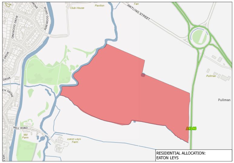
Plan:MK Schedule of Proposed Additional Modifications – October 2018
AddM5 4 Table 1.1 Update Dates and timetable column for Adoption of Plan:MK to reflect the latest timetable Correction
Plan-making stage Dates and timetable
Adoption of Plan:MK Winter 2018 Spring 2019
AddM6 8 Strategic Amend as follows: To provide clarity
Objective 2
To deliver land for a minimum of 26,500 net new homes within the Borough between 2016 and 2031, principally within and adjacent to the
city.
AddM7 10 Strategic To work with public service and infrastructure providers (principally via the Local Investment Plan) to ensure that the social and economic To strengthen
Objective 17 growth planned in the Borough and neighbouring local authorities is facilitated by the timely provision of appropriate new and improved provisions for
facilities such as public transport, schools, green infrastructure, community halls, sport and recreation facilities, transport interchanges, green
health services (including Milton Keynes University Hospital), emergency services. infrastructure
within Plan:MK.
AddM8 10 Strategic To protect, maintain and enhance the natural, built and historic environment of the Borough, including its important linear parks, To clarify the
Objective 15 sustainable urban drainage systems, character and assets of the New City and the towns and villages throughout the Borough, and to scope of the
protect and maintain the open countryside in the Borough. objective using
recognised
terminology
AddM9 13 Para 4.4 The Council’s housing target for Plan:MK is therefore to set the OAN as a minimum target, delivering a total of at least 26,500 net dwellings To provide clarity
between 2016 and 2031.
….the plan allocates land for approximately 29,000 30,900 dwellings, thus providing a land supply buffer above the OAN of approximately 9.7 Update following
16.7%. site specific
changes as
outlined in
proposed
modifications to
Appendix A
AddM10 14 Table 4.1 Table 4.1 Components of Housing Land Supply 2016 – 2031 as at April 2017 2018 To update housing
land supply to a
Number of homes required to be built 26,500 base date of 1
Number of dwellings completed 2016/17 – 2017/18 1,247 2,750 April 2018.
Total Existing Commitments 20,603 18,138
Remaining requirement to be met through Local Plan allocations 4,650 5,612
AddM11 14 Para 4.8 Taking into account the above, and in addition to sources of supply listed, there is a need for sites to deliver a minimum of 4,650 5,612 Update to reflect
additional dwellings, to be identified over the plan period, so as to meet OAN. To provide the required land supply buffer in the region of at updated housing
least 10% above the OAN, sites for at least a further 2,650 dwellings are also required. land supply
position base date
of 1 April 2018.
AddM12 14 Para 4.9 To deliver the 4,650 5,612 additional dwellings and a buffer….. Update to reflect
updated housing
land supply
position base date
of 1 April 2018.
3
Plan:MK Schedule of Proposed Additional Modifications – October 2018

AddM13       14                Para 4.10          Whilst sites within the existing urban area, identified by the SHLAA, and the continuation of a windfall allowance across the plan period can    Factual update to
                                                  provide approximately 4,230 dwellings a significant number of dwellings, it this is not sufficient to meet either the OAN or the required land   account for the
                                                  supply buffer necessary to make Plan:MK an effective plan. To provide the 3,000 dwellings additionally required dwellings, Plan:MK has           updated housing
                                                  allocated a site to the south-east of the existing urban area and a further site, subject to the funding and delivery of necessary strategic     land supply
                                                  infrastructure, to the East of the M1 Motorway.                                                                                                  position base date
                                                                                                                                                                                                   changing to 1 April
                                                                                                                                                                                                   2018.
AddM14       15                Para 4.14          CMK: Central Milton Keynes and Campbell Park residential area will now see the delivery of some 1,900 3,535 dwellings on sites identified        Factual update to
                                                  via the SHLAA (2017). These are in addition to the approximate 2,450 1,025 dwellings which are already committed. (Committed and new             account for
                                                  sites are outlined in Appendix A and new allocated sites are listed in Policy DS2).                                                              Campbell Park
                                                                                                                                                                                                   Northside being
                                                                                                                                                                                                   considered an
                                                                                                                                                                                                   allocation rather
                                                                                                                                                                                                   than an existing
                                                                                                                                                                                                   commitment.
AddM15       15                Para 4.15          …children’s play space, surface water attenuation and strategic landscaping green infrastructure.                                                Use of correct
                                                                                                                                                                                                   terminology
AddM16       15                Para 4.18          With the requirement to provide enough land to meet the OAN and provide a land supply buffer to enable the plan to be effective, Plan:MK         Update to account
                                                  allocates land in this area to provide a total of 3,000 dwellings. This, alongside potential delivery of dwellings at the East of M1 site        for inclusion of
                                                  within the plan period, enables the provision of a land supply buffer of approximately 9.7 16.7%. However, with the aspiration and desire to     potential housing
                                                  actively encourage the inclusion and facilitation of the Oxford-MK-Cambridge Expressway, which will provide a much needed infrastructure         supply from East
                                                  upgrade for both local residents and the regional economy, Plan:MK recognises that the figure of 9.7 16.7% could be reduced depending            of M1 site.
                                                  upon the outcome of future decisions on the alignment of the Oxford-MK-Cambridge Expressway.
AddM17       15                Para 4.19          Amend final sentence in bullet point on Small Sites in Para 4.19, so as it reads:                                                                To reflect
                                                                                                                                                                                                   allocated sites
                                                  The sites are listed in Appendix A – Housing Sites within this plan Policy DS2, whilst some have site-specific policies that are set out in      being listed in
                                                  Policies SD20 and SD21 in Chapter 5.                                                                                                             Policy DS2 rather
                                                                                                                                                                                                   than Appendix A.

                                                  Amend penultimate sentence in bullet point on Regeneration in para 4.19. Delete reference to Central Bletchley Urban Design Framework            To reflect the
                                                  and replace by the Central Bletchley Prospectus Area.                                                                                            change in the title
                                                                                                                                                                                                   of this work from
                                                  Projects, such as within the area of the Council-led Central Bletchley Urban Design Framework Prospectus, which are is currently being           Urban Design
                                                  produced, may lead to opportunities which could provide additional residential development. Again, this would assist in providing further        Framework to
                                                  flexibility and a buffer to housing supply.                                                                                                      Prospectus.

AddM18       16                Para 4.23          The provision of new homes and jobs from 2016 to 2031, as outlined in the Settlement Hierarchy within Policy DS1, will be focused on,            To add clarity
                                                  and adjacent to the existing urban area of Milton Keynes and the three key settlements which are considered the most sustainable
                                                  rural settlements taking into account their population, constraints, transport links and the capacity of services within the town.
                                                  Provision will also be focused on the opportunities provided by the completion of East-West Rail and the new Cambridge-Milton Keynes-
                                                  Oxford growth corridor.
AddM19       17                Policy DS1         3rd Bullet Point of “New Strategic Growth Areas” column:                                                                                         Update to be
                                                                                                                                                                                                   consistent with
                                                     •   Land East of the M1 (post 2031)                                                                                                           Policy SD14.

                                                                                                            4
Plan:MK Schedule of Proposed Additional Modifications – October 2018
AddM20 27 Para 4.51 Revised
Amend future forecasted requirements for comparison floorspace and floorspace for the food and beverage floorspace in paragraph 4.51. floorspace figures
in table 4.51
reflect final
The quantity of floorspace forecast at 39,689 33,490 sq.m (net) of floorspace by 2031, around 40,000 sq.m is a significant reduction on the floorspace figures
capacity of 82,000-130,000 sq.m up to 2026 identified in the Council’s previous Retail Capacity Update (RCU) in 2011. in the MK Retail
capacity and
Leisure Study
Additional capacity of between 4,954-12,292 sq.m (gross) by 2022 and 15,268-37,886 4,053 sq.m (gross) is forecast by 2031. 2018.
AddM21 28 Para 4.56 Amend last sentence of para 4.56, delete reference to Urban Design Framework and replace by the Prospectus. To reflect the
change in the title
Another major area of change will be in and around Bletchley town centre where the Council will seek to build on the opportunities of this work from
created by east-west rail and the work undertaken for the Bletchley ‘Fixing the Links’ project by developing a Central Bletchley Urban Design Urban Design
Framework Prospectus for the development of sites around Bletchley railway station. Framework to
Prospectus.
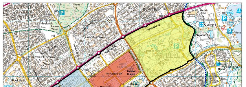
AddM22 28 Para 4.57 Amend first sentence of paragraph 4.57 to reflect the area now proposed as comprising the CMK Primary Shopping Area. Modification to
Primary Shopping
Area (PSA) of
4.57 Within CMK additional comparison retail floorspace will be concentrated within the Primary Shopping Area (PSA) between Silbury CMK required
Boulevard and Avebury Boulevard, Saxon Gate and Marlborough Gate. and including the area around the Xscape building between Avebury following
Boulevard, Childs Way, Secklow Gate and land west of Marlborough Street. Inspector’s letter
after the stage 1
hearings. (Point
10 in document
INS 4 refers.) The
PSA should reflect
the PSA in the
adopted Core
Strategy.
AddM23 28 Para 4.59 To clarify that
Final sentence of para 4.59 after CMK Renaissance Investment Programme add now the Prospectus for CMK. work on the CMK
Renaissance is
being taken
forward by the
Council via a
‘Prospectus for
CMK’ rather than
a CMK
Renaissance
Investment
Programme
5Plan:MK Schedule of Proposed Additional Modifications – October 2018
AddM24 28 Para 4.60 The CMK Renaissance is will be progressed progressing pending the outcome of that work via the CMK Prospectus. To update details
The prospectus is primarily intended to encourage additional private sector investment and development in CMK. It is aspirational about the CMK
in nature and outlines the key features of future development likely to be required to ensure that CMK reflects the needs and Renaissance and
desires of its users (citizens workers and visitors) becoming not only the centre piece of the city but also a regional hub in the clarify the
years up to 2050. The Prospectus does not aim to create planning policy for Central Milton Keynes although a key aim is to help to relationship
improve the conditions where existing policy (the 2015 CMK Alliance Plan) as amended by Plan:MK can be more effectively driven between it and the
and development delivered to benefit the city centre. Over the next 15 years demand for retail, leisure and cultural floorspace etc within CMK Prospectus.
the city centre will be met either by the development of sites already in the development pipeline (some major schemes are listed below) , or
by the development of vacant sites and the redevelopment of existing buildings
AddM25 29 Para 4.62 Amend first sentence of para 4.62, delete reference to Urban Design Framework and replace by the Prospectus. To reflect the
change in the title
4.62 There may be development opportunities for retail and leisure development within Bletchley town centre following the production of the of this work from
Central Bletchley Urban Design Framework Prospectus. Urban Design
Framework to
Prospectus.
AddM26 29 Figure 1 Amendments to Figure 1 CMK City Centre Boundary Map to reflect the area now proposed as the CMK Primary Shopping Area no longer Modification to
includes the area around the Xscape building. Primary Shopping
Area (PSA)
required following
Inspector’s letter
after the stage 1
hearings. (Point
10 in document
INS 4 refers.) The
PSA should reflect
the PSA in the
adopted Core
Strategy.
6Plan:MK Schedule of Proposed Additional Modifications – October 2018
AddM27 30 DS4 Amend paragraph relating to Bletchley in Policy DS4 to refer to the Central Bletchley Prospectus rather than the Urban Design Framework. To reflect the
change in the title
of this work from
In Bletchley: Urban Design
Framework to
Milton Keynes Council will prepare a Central Bletchley Urban Design Framework Prospectus to facilitate and promote mixed-use Prospectus.
development around Bletchley Railway Station and the intensification of development in sustainable locations with good access to public
transport hubs, building on the opportunities created by the development of east-west rail and the work undertaken in the Bletchley ‘Fixing the
Links’ project.
AddM28 30 DS4 Other District and Town Centres Other Town and District Centres Clarity with retail
hierarchy
AddM29 30 DS4 Criterion 5 Add cross-reference to policy ER10 in criterion 5 Inspector’s Action
Point 37. To
After residential development. Add ‘See also Policy ER10.’ improve
comprehension of
plan
7Plan:MK Schedule of Proposed Additional Modifications – October 2018
AddM30 31 Figure 2 Replacement of the Key Diagram at Figure 2 into a more schematic diagram: To better
represent the
geographical
location of the
proposed strategic
sites in relation to
the MK borough
boundary, key
settlements and
key transport
corridors.
AddM31 31 Figure 2 Modify colour of SLA within the Figure 2 to be grey. Correct error and
reflect PM24,
Adjust boundaries for ‘Strategic Urban Extension: South East’ as per PM24 and PM PM25 and PM30
Adjust boundaries for ‘Strategic Urban Extension: Eaton Leys’ as per PM
AddM32 34 DS6 Within this area any new leisure and recreation development should be consistent with the objectives set out above, those in Policy NE3 and Correction.
Policy NE4, and the site specific following requirements.
AddM33 34 DS6 Addition: To represent the
correct name.
1. The Loughton Brook Valley and Tattenhoe Valley
8Plan:MK Schedule of Proposed Additional Modifications – October 2018
AddM34 34 DS6 Correction: To correct a
typographical error
2. Proposals for new development should provide for increased public access within the area (including a footpath route along the Ouse and for
Valley) providing any access areas/paths are located and managed in such a way as to ensure no detrimental acceptable impact on consistency.
ecological resource, particularly within the Great Linford Gravel Pitts BNS and the River Ouse BNS.
AddM35 39 5.13 Text revised to
5.13 A major area of change over the plan period is the city centre. In order to help stimulate investment within the city centre and help CMK reflect the
realise its full potential in the Cambridge-Milton Keynes-Oxford corridor, a prospectus for CMK to take forward the CMK Renaissance preparation of a
concept document will be will be prepared. Prospectus for
Further documents will need to be produced by the Council such as Supplementary Planning Documents (SPDs) and Development briefs CMK, which will
to help deliver key projects in CMK. such as the development of educational institutions and to help realise the vision and agreed way take forward the
forward for the city centre. CMK Renaissance
Also to avoid
giving the
impression that
the preparation of
SPD’s /
Development
Briefs in CMK
depends upon the
Prospectus.
AddM36 41 SD4 Amend second bullet point: To strengthen
provisions for
An enhanced and high quality network of pedestrian/cycle routes, public open spaces and squares, and green infrastructure. green
infrastructure
within Plan:MK.
AddM37 42 Policy SD5 missing (numbered SD4, no SD5, then SD6…) Numbers out of
sequence
Renumber subsequent policies accordingly
AddM38 43 SD7 Proposed change: The title currently
reflects the wrong
WESTERN EXPANSION AREA (formerly policy EA6 EA5 in the Milton Keynes Local Plan) policy from the
former MKC Local
Plan (2005)
AddM39 44- SD8 Amend policy SD8 for the Strategic Land Allocation (SLA) to delete references to Core Strategy policies and the CS key diagram figure To update Policy
45 5.2 and appendix E and refer to relevant replacement Plan:MK policies and Plan:MK Key diagram. Plan:MK policy SC3 would replace SD8 and replace
reference to Core Strategy policy CS14 at criterion 7 and Plan:MK policies HN1,HN2 and HN11 would replace the reference to policy CS10 at references within
criterion 10 the policy to
deleted CS
policies and the
CS key diagram
with relevant
replacement
Plan:MK policies
and the Plan: MK
key diagram.
AddM40 45 SD8 Point 8 Will Ccarefully consider the conservation and enhancement of the special interest, character, appearance and significance of designated To aid clarity
heritage assets andwithin their setting, as part of the positive strategy for the conservation and enjoyment of, and clear strategy for
enhancing, the historic environment as required by the NPPF.
9Plan:MK Schedule of Proposed Additional Modifications – October 2018
AddM41 45 SD8 Point 12 Amend point 12: To bring into line
with the NEP’s
Take a strategic and integrated approach to flood management and provide a strategic and sustainable approach to water resource principles for local
management, including Sustainable Drainage Systems (SuDS) and flood risk mitigation, which look for opportunities for biodiversity plans and
enhancement through design. strengthen
provisions for
achieving net
gains in
biodiversity
AddM42 46 Policy Amend policy to delete reference to: Newton Leys is identified as a special area on the Proposals Map. This is no longer
SD9 necessary and
therefore plan
should be
updated.
AddM43 47 Para 5.17 Delete the third bullet point at para 5.17 referring to ‘Land at Eaton Leys for a residential-led development’ Eaton Leys now
has outline
planning
permission (MKC
Ref
15/01533/OUTEIS
) and is no longer
a housing
allocation. The
wording of para
4.15 may need
amending to
reflect this
change.
AddM44 48 Policy SD10 missing (numbered SD9, no SD10, then SD11…) Numbers out of
sequence
Renumber subsequent policies accordingly
AddM45 48 SD11 Amend fifth bullet under section 3: To improve
effectiveness for
A landscape green infrastructure and open space strategy to improve biodiversity, provide advanced structural planting, extend the forest and strengthen
city concept, create green road and street scenes, and incorporate public art and leisure and recreation facilities. provisions for
green
New bullet point under section 3: infrastructure
within Plan:MK.
The monitoring of biodiversity or green infrastructure improvements should be delivered in accordance with the relevant
Development Brief.
AddM46 48 SD11 Add the following words at end of policy To clarify that any
planning
This policy will also be applied to any planning application for unallocated strategic development sites. application for an
unallocated
strategic
development site
will be considered
against the
principles in policy
SD11.
10Plan:MK Schedule of Proposed Additional Modifications – October 2018
AddM47 49 SD12 1 To ensure that Strategic Urban Extensions are brought forward in a strategic and comprehensive manner, planning permission will only be To strengthen
granted for land within Strategic Urban Extensions, following the approval by the Council of a comprehensive development framework, provisions for
incorporating any necessary design codes, or phasing of development and infrastructure delivery, including green infrastructure delivery, green
for the Strategic Urban Extension as a whole. infrastructure
within Plan:MK.
AddM48 49 5.24 Amend and add additional text: To reflect changes
made to Policy
Because the Council wishes to encourage economic growth, prosperity and job creation within the Oxford – Cambridge arc, it will work with SD13, provide
developers and relevant infrastructure providers to determine the timing and phasing of this housing delivery over the plan period, taking into further guidance
account the ongoing infrastructure planning being undertaken by other agencies in respect of East West Rail and the Oxford to Cambridge for interpreting the
Expressway proposals. policy, and to
shape and reflect
Due to the close relationship between this development area and the East-West Rail line, South East Milton Keynes SUE benefits the significance of
from being in close proximity to the Marston Vale Rail Line with services from Woburn Sands and Bow Brickhill into Bletchley and the emerging
Central Milton Keynes (via Bletchley), as well as Bedford. The Marston Vale Rail Line will itself become part of the East West Rail Development
Line connecting Oxford to Cambridge and as such will benefit from new services to these and other regional centres within the Framework.
wider Oxford-Cambridge Arc. The Council, with the support of the National Infrastructure Commission, has also developed a
Strategy for First Last Mile Travel, to ensure Milton Keynes has good connectivity with nationally significant infrastructures projects
such as East West Rail and Oxford to Cambridge Expressway, with improving the connectivity between Bletchley and Central
Milton Keynes an important strand within the strategy. the Council is proactively working towards tThe Council will work with the
town/parish councils of Woburn Sands, Wavendon and Bow Brickhill and developers and infrastructure providers to prepare a
development framework which maximises the opportunities for sustainable travel that both the existing and planned services will provide. The
principal vehicular access to the site should be sought via an extended H10 Grid Road that is delivered ahead of occupation of new
housing within the site
A comprehensive transport strategy shall be established through the Development Framework process, informed by transport
modelling and stakeholder engagement undertaken by the Council, to ensure that appropriate access to and from site, and
connectivity of the southern areas of the site across the railway, is achieved in line with other policies within the plan and the aims
and objectives of the Council’s Mobility Strategy. Bridge crossing(s) of the railway will be required to meet place making and
connectivity objectives and requirements of the Plan, and potentially to provide strategic highway solutions to manage strategic
flows of traffic around the south east of Milton Keynes. The purpose of any bridge crossing(s) (for example for highway, public
transport, pedestrian and / or cyclist routes) will be set out within the Development Framework as informed by further detailed
transport modelling and stakeholder engagement. The Development Framework will also set out what other strategic and local
highway connections and improvements should be provided and how these will be delivered, including between the A421, H10, A5,
V10 and V11.
The Development Framework process will also be used to establish the appropriate location for the Gypsy and Traveller site; define
the location and size of primary and secondary schools to meet the educational needs arising from the development; provide a
development layout and use buffers and structural landscaping that avoids coalescence and significant inter-visibility of the site
with the villages of Woburn Sands and Bow Brickhill; show how impacts on the lowland meadow priority habitat will be avoided and
mitigated in line with Policy NE2; and show the provision of green infrastructure, community facilities, recreation and open space
and other amenities, services and infrastructure in line with other relevant policies within the Development Plan.
11Plan:MK Schedule of Proposed Additional Modifications – October 2018
AddM49 53 Map 3 Adjust boundaries for ‘Strategic Urban Extension: Eaton Leys’ to omit the Scheduled Monument and reproduce Map 3 to reflect this To reflect PM4
AddM50 54 SD15 Amend sixth bullet point: The make the
policy effective
Multi-functional and well-connected public open space, informal amenity space, children's play space, open space incorporating the setting and consistent
of the scheduled monument and other areas of archaeological interest, surface water attenuation and strategic landscaping. with national
planning policy
Amend seventh bullet point: and to address
Historic England’s
A layout that respects the Scheduled Monument, its setting and other areas of archaeological interest by avoiding the Monument and concerns.
these areas, allowing their preservation in situ, to be demonstrated by a management plan which shall be submitted for approval in writing
by the Council .
AddM51 56 SD16 Amend second paragraph: Agree that the
specific on site
The development will be brought forward in line with all relevant policies in Plan:MK, particularly Policy SD1, SD11, SD12, NE1-6 and INF1 sensitivities should
be referenced, but
suggest that detail
should be within
the supporting
text.
12Plan:MK Schedule of Proposed Additional Modifications – October 2018
AddM52 56 SD16 In Policy SD16 amend second paragraph of policy. Change to policy
is to cross
reference the
A comprehensive development framework for the site will be prepared and the development will be brought forward in line with all Development
relevant policies in Plan:MK particularly policies SD1 , SD11, SD12 and INFI prior to planning applications being approved. Framework SPD
for this site.
AddM53 57 Para 5.31 …The Council therefore expects that any such development must It is therefore the Council’s preference that any such To clarify the
development should function as a sustainable urban extension to Milton Keynes as well as being supported by the local planning authorities Council’s
responsible… approach to
developments
adjoining the
Milton Keynes
council area
AddM54 58 SD17 Criteria 5 … To add clarity
It is expected that development proposals that support the Oxford to Cambridge Growth Arc will focus significant new development
on MK in the plan period. When development comes forward for an area that expands the city of Milton Keynes which is wholly or partly
within the administrative boundary of a neighbouring authority, this Council will work jointly to achieve the city vision for 2050 and the growth
arc. MK put forward the following principles of design and development during the joint working on planning, design and implementation:
…
5. Linear parks should be extended into the development where possible to provide recreational, walking and cycling links within the
development area and to continue the city’s extensive green infrastructure and redway network.
AddM55 59 SD19 Change ‘Central Bletchley Urban Design Framework’ above paragraph 5.35 and in paragraph 5.35 to Central Bletchley Prospectus Area To reflect the
change in the title
of this work
AddM56 60 SD19 Additional criteria: To improve
effectiveness of
9. The development will provide green infrastructure in line with Policy NE4, providing wellbeing benefits through access to nature. policy
AddM57 60 SD19 In policy SD19 change ‘Central Bletchley Urban Design Framework’ in title of policy and in line 1 of the policy to Central Bletchley To reflect the
Prospectus Area change in the title
of this work. As a
consequence of
this change in title
there will be a
need to change
policy DS4 which
also mentions the
CBUDF.
AddM58 61 SD20 Amend criteria 4 and add a new criteria To improve
effectiveness of
4. The existing hedge across the site should be retained and kept in the public domain and incorporated in to on-site green infrastructure policy consistency
in line with Policy NE4. with para 117 of
the NPPF.
5. The vegetation bordering the A5 is Priority habitat - deciduous woodland. This vegetation must be conserved and enhanced
wherever possible.
AddM59 64 Footnote 12 Amend final sentence of footnote 12 Map being
referred to is the
“…as defined on the proposals policies map”. Policies Map
13Plan:MK Schedule of Proposed Additional Modifications – October 2018
AddM60 65 Para 6.7 Amend first line of para 6.7 replace ‘2017’ by ‘2018’. Final version of
the retail & leisure
6.7 Milton Keynes Retail Capacity and Leisure Study 2017 2018. study was
produced in 2018.
AddM61 65 Para 6.8 Revised figures for
comparison
Amend third sentence of para 6.8 to reflect final comparison floorspace figures in the Milton Keynes Retail Capacity and Leisure Study, floorspace in the
March 2018 Borough up to
2031 reflect
figures in final
The quantity of floorspace forecast at 39,689 33,490 sq.m (net) of floorspace by 2031, around 40,000 sq.m is a significant reduction on the version of the
capacity of 82,000-130,000 sq.m up to 2026 identified in the Council’s previous Retail Capacity Update (RCU) in 2011. Council’s Retail
Capacity and
Leisure Study
2018.
AddM62 67 ER1 Planning permission will be granted for employment uses listed in Table 6.1 and shown on the Proposals Policies Map. Map being
referred to is the
Proposals for more than 1000 sq. m of B1(a) floorspace and proposals for more than 2000 sq. m of B1(b) floorspace, which can clearly Policies Map
demonstrate, with evidence, why they cannot be accommodated within CMK, will be permitted on employment sites shown on the proposals
Policies map, with good transport links.
14Plan:MK Schedule of Proposed Additional Modifications – October 2018
AddM63 67- Table 6.1 Update Table 6.1
68 as at April 2018.
Grid Square Area Use Class Area (ha)
Bletchley B1/B2/B8 2.4
Brickfields/Newton
Leys
Crownhill B1/B2/B8 1.2
Eagle Farm North B1/B2/B8 25.2
Knowlhill B1/B2/B8 5.9
Linford Wood B1 5.1
Magna Park B2/B8 9.8
Milton Keynes East B1/B2/B8 125
Mount Farm B1/B2/B8 1.9
Pineham B2/B8 10.9
Redmoor B2/B8 1.7
Rooksley B1/B2/B8 1.3
Shenley Wood B1/B2/B8/C2/D1 10.8
Snelshall East B1/B2/B8 4.7
Snelshall West B1/B2/B8/C1 5.1
South Caldecotte B2/B8 56.8
Walton B1/B2/B8 2.2
West Ashland B1/B2/B8 1.1
Western Expansion B1/B2/B8 17
Area
Willen Lake B1 1.1
Wolverton B1/B2/B8 2.6
Wolverton Mill East B1/B2/B8 5.6
& South
Wymbush B1/B2/B8 1.2
Total amount of 298.6
land
Notes
1. Base date for Table is April 2018
2. Figures in table exclude areas of less than 1 hectare and land for mixed use development in in Central Milton Keynes.
AddM64 70 ER2 Within the Borough, planning permission will be refused for the change of use or redevelopment of any land identified for employment use on Map being
the Proposals Policies Map and for any building used for employment purposes (whether identified on the Proposals Policies Map or not) to referred to is the
another purpose, unless the applicant can demonstrate there would be no conflict with existing or potential neighbouring uses and: Policies Map
AddM65 74 ER7 missing (Numbered ER6, no ER7, then ER8…) Numbers out of
sequence. Original
Renumber subsequent policies accordingly. policy ER7 revised
and moved to
Chapter 12
AddM66 74 Para 6.31 Policy ER7 (Controlling the Risk of Pollution) has been revised and moved to Chapter 12.
AddM67 76 ER9 Criterion 2 of policy ER9 reads better if ‘the’ between ‘for’ and ‘farm’ is deleted from the policy To improve
comprehension of
Amended criterion 2 to read: the policy.
2 “Schemes for the farm diversification involving small-scale business and commercial development.
15Plan:MK Schedule of Proposed Additional Modifications – October 2018
AddM68 77 ER10 Table 6.2 Amend criteria 4 and final paragraph: To add clarity
4. Local centres: Existing local centres, as shown on the Policies Map and listed in Appendix G, will provide convenience shopping and
service facilities in order to reduce car dependency and to ensure ready access by non-car owning households and other people with limited
or impaired mobility.
Planning permission will be granted for retail and service uses to serve new areas of residential development. The scale of retail and service
provision provided within new areas of residential development will be determined in Development Frameworks for those areas to cater for
the day to day shopping needs of the resident population and not draw trade from a wider area.
AddM69 77 6.44 Amend third sentence of paragraph 6.44 to reflect the area now proposed as the CMK Primary Shopping Area no longer includes the area Modification to
around the Xscape building. Primary Shopping
Area (PSA)
required following
6.44 The city centre of Central Milton Keynes, with ‘the centre:MK’ (formerly the Shopping Building) and Intu Milton Keynes (formerly Inspector’s letter
Midsummer Place) has the largest concentration of retail floorspace within the city. It is defined as the area of land between the West Coast after the stage 1
main railway line, the Grand Union canal, H5 Portway and H6 Childs Way. The primary shopping area (PSA) of CMK is defined in policy SD2. hearings. (Point
; it has been expanded to take in the area around the Xscape building. Assuming existing planning permissions are implemented and 10 in document
vacant sites are developed over the plan period, the PSA will be a major area of change. INS 4 refers.) The
PSA should reflect
the PSA in the
adopted Core
Strategy.
AddM70 79 6.49 Para 6.49 This policy aims to give guidance on how the Council will assess proposals for main town centre uses outside of town centres. The To reflect changes
Council will follow the sequential approach to assessing development proposals. To assess the impact of a development proposal outside to ER11
of Central Milton Keynes/ the city centre, the Council will require aAn impact assessment if the proposal exceeds 2,500 sq.m
(gross)will be required for retail uses outside of the CMK primary shopping area which exceed 900 sq.m (gross) floorspace and
leisure uses outside of the city centre, which exceed 900 sq.m (gross). For office development outside the city centre, see policy ER1.
AddM71 79 Footnote 15 Amend definition of edge of centre in footnote 15 To reflect the
definition of edge
For a further definition of the terms main town centre uses, town centre, edge of centre and out of centre, see the glossary. For retail of centre in the
purposes, edge of centre is defined in the NPPF as a location that is well connected to, and up to 300 metres of from, the primary shopping NPPF (July 2018)
area.
AddM72 80 6.54 This policy relates to shops, post offices, banks and public houses within the settlements of Newport Pagnell, Olney, Stony Stratford and To add clarity to
Woburn Sands and to local centres including village shops in settlements within the rural area of the Borough. It does not relate to the the purpose of
city centre and to the town centres. Additionally this policy does not apply to shops in local centres within the city. ER12
AddM73 81 ER12 Planning permission will be refused for changes of use that involve the loss of an existing shop, post office, bank and public house unless: To add clarity and
ensure
1. All means of retaining the use has been explored and ; consistency with
2. The Council is satisfied that the existing use is no longer commercially viable other policies in
the plan
For shops in local centres within the City see policy ER14.
16Plan:MK Schedule of Proposed Additional Modifications – October 2018
AddM74 82 ER14 NON RETAIL USES IN LOCAL CENTRES WITHIN THE CITY To add clarity
Planning permission will be granted for non-retail uses in Local Centres within the city if:
2. At least one general convenience store will remain in the centre.
3. The proposed use would not adversely affect the amenity of neighbouring properties or the surrounding area
AddM75 82 ER15 Amend policy ER15 (NEW LOCAL CENTRES) to add a reference to a new local centre being provided at Redhouse Park. Policy SD21 for
the Walnuts site at
After 7. Western Expansion Area (WEA) add 8. Redhouse Park (in line with Policy SD21) Redhouse Park
allocates the
eastern portion of
this site for retail
and /or
employment
development.
However, policy
ER15 (New Local
Centres) does not
identify the
Walnuts site at
Redhouse Park as
an area for a new
local centre.
Policies Map will
need to be
modified to show
Redhouse Park as
a local centre.
AddM76 83 Para 6.61 Amend second sentence of para 6.61, delete reference to Urban Design Framework and replace by the Prospectus. To reflect the
change in the title
The preparation of a Central Bletchley Urban Design Framework Prospectus may provide an opportunity to develop a hotel in close proximity of this work from
to the existing visitor attractions at Bletchley Park. Urban Design
Framework to
Prospectus.
AddM77 84 ER17 Planning permission will be granted for new hotel and other purpose-built visitor accommodation in CMK, town and district centres either as To ensure
single use or as part of mixed-use development opportunities. The Council will also support the provision of new hotels and visitor consistency with
accommodation to serve visitor attractions within the city. Policy SD2
…
AddM78 84 ER18 Amend criterion 1: To ensure
consistency with
The development is of a use, form and scale which does not harm the quality of the natural, or built or historic environment and; the NPPF by
giving due regard
to the historic
environment
alongside the
natural and built
environment.
17AddM79 86- Table 6.3 Changes to
87 Bletchley: Secondary Shopping Frontages have been amended to include 2-6 Brooklands Road, Chandos Place, 4-8 Duncombe Street, 2-3 boundaries and
Oxford Street, Woodward House, & 2a Cambridge Street. shopping
Plan:MK Schedule of Proposed Additional Modifications – October 2018
frontages made to
Olney: Primary Shopping Area has been extended to include the Secondary Shopping Frontage at 2-16 High Street. reflect final
recommendations
Newport Pagnell: The Town Centre Boundary has been extended to include the Secondary Shopping Frontages at 100-122, 122-129 High in Retail capacity
Street & 1 Station Road. The Primary Shopping Area has been extended to include the Secondary Shopping Frontages at 1-13 High Street, and Leisure Study
100-122, 122-129 High Street & 1 Station Road. (2018)
Stony Stony Stratford: Town Centre Boundary has been amended to exclude land to the south of Mill Lane. The Primary Shopping Area
boundary has been extended to include the Secondary Shopping Frontage on Church Street.
The Primary Shopping Frontage has been deleted from Cofferidge Close and extended on the High Street to the Cock Hotel (north side) and
Lloyds Bank (south side).
The Secondary Shopping Frontage has been deleted from 59-67 High Street and 64a-Cock Hotel High Street.
Wolverton: The Primary Shopping Area has been amended to exclude land to the north of Stratford Road. The Primary Shopping Frontages
have been amended to delete the Tesco’s frontage. The Agora (Church Street) frontage has been changed from a Secondary Shopping
Frontage to a Primary Shopping Frontage. The Secondary Shopping Frontages have been amended to include frontages on Glynn Square
(eastern edge), Creed Street and Radcliffe Street.
BLETCHLEY
Primary Frontages • Additional non-retail uses may be
acceptable within a block of properties,
subject to the frontages of all non-retail
uses in that block not exceeding 45% of
the total frontage of that block
Queensway (west of Cambridge
St);
Brunel Centre (including
Sainsbury’s)
Secondary Frontages • No restrictions on the proportion of units
in non-retail use
133-153, 162-188 Queensway;
Wilkinsons; Brunel Centre; 4-8
Duncombe Street; Chandos
Place;2-6 Brooklands Road;
Woodward House, 2a
Cambridge Street; 2-3 Oxford
Street.
CENTRAL MILTON KEYNES
Primary Frontages • No restrictions on the proportion of units
in non-retail use
All of the centre:MK and the Intu
Milton Keynes buildings
Secondary Frontages • No restrictions on the proportion of units
in non-retail use
•
The Milton Keynes Theatre District
and the Xscape building 18AddM79 86- Table 6.3
87
Plan:MK Schedule of Proposed Additional Modifications – October 2018
KINGSTON
Primary Frontages • Change of use involving the loss of A1
retail will not normally be acceptable
• Change of use from one non-retail to
another non-retail use may be
acceptable
• Change of use from non-retail use to A1
retail use will be encouraged
1, 26-34, 35-39, 47-52
Winchester Circle
Secondary Frontages • No restrictions on the proportion of units
in non-retail use
Standalone units
NEWPORT PAGNELL
Primary Frontages • Change of use involving the loss of A1
retail will not normally be acceptable
• Change of use from one non-retail to
another non-retail use may be
acceptable
• Change of use from non-retail use to A1
retail use will be encouraged
17-49, 53-77, 22-86 High Street
Secondary Frontages • No restrictions on the proportion of units
in non-retail use
1-21, 4-26 St John Street; 1-13,
79-111, 100-122, 127-129 High
Street; 1 Station Road
OLNEY
Primary Frontages • Change of use involving the loss of A1
retail will not normally be acceptable
• Change of use from one non-retail to
another non-retail use may be
acceptable
• Change of use from non-retail use to A1
retail use will be encouraged
1, 5-11, 14-38 Market Place; 25-35
High Street
Secondary Frontages • No restrictions on the proportion of units
in non-retail use
2-16 High Street
19Plan:MK Schedule of Proposed Additional Modifications – October 2018
AddM79 86- Table 6.3
87
STONY STRATFORD
Primary Frontages • Change of use involving the loss of A1
retail will not normally be acceptable
• Change of use from one non-retail to
another non-retail use may be
acceptable
• Change of use from non-retail use to A1
retail use will be encouraged
High Street (Wolverton Road to
York Road) Cofferidge Close
Secondary Frontages • No restrictions on the proportion of units
in non-retail use
High Street (York Road to Fagans
Court); St Marys and St Giles
Church, 5-7, 2-12 Church Street
WESTCROFT
Primary Frontages • Change of use involving the loss of A1
retail will not normally be acceptable
• Change of use from one non-retail to
another non-retail use may be
acceptable
• Change of use from non-retail use to A1
retail use will be encouraged
4-10, 19-22a Barnsdale Drive; 10-
12 Wimborne Crescent
Secondary Frontages • No restrictions on the proportion of units
in non-retail use
1, 25-26, 11-18 Barnsdale Drive;
4-8 Wimborne Crescent
20Plan:MK Schedule of Proposed Additional Modifications – October 2018
AddM79 86- Table 6.3
87
WOBURN SANDS
Primary Frontages • Additional non-retail uses may be
acceptable, subject to the units in non-
retail use not exceeding 20% of all units
in the primary area.
5-75 High Street
Secondary Frontages • No restrictions on the proportion of units
in non-retail use
1, 2-12 High Street
WOLVERTON
Primary Frontages • Change of use involving the loss of A1
retail will not normally be acceptable
• Change of use from one non-retail to
another non-retail use may be
acceptable
• Change of use from non-retail use to A1
retail use will be encouraged
1-21 Stratford Road; 6-84 Church
Street; 1-5 Creed Street; Agora
(Church Street) Glyn
Square,Tesco’s
Secondary Frontages • No restrictions on the proportion of units
in non-retail use
1-21, 2-26 The Square; Milton
Keynes Christian Foundation,
Aylesbury Street; Agora
(Buckingham Street); 22-48, St
Francis de Sales Church, Stratford
Road west of Radcliffe Street,
Glyn Square; Radcliffe Street;
Creed Street (western side)
21Plan:MK Schedule of Proposed Additional Modifications – October 2018
AddM80 89 Para 6.70 Delete para 6.70, referring to a review of Primary and Secondary Shopping Frontages and the extent of the Primary Shopping Area in There are no
Bletchley as part of work associated the Central Bletchley Urban Design Framework plans for the
Central Bletchley
6.70 Note: Work will be undertaken as part of the Central Bletchley Urban Design Framework, which may result the Primary and Secondary Prospectus to
Shopping frontages and the possible extent of the Primary Shopping Area in Bletchley being redefined. review the Primary
and Secondary
Shopping
frontages and the
possible extent of
the Primary
Shopping Area in
Bletchley.
AddM81 93 HN1 Amend Criterion 2. B of policy HN1, delete reference to Urban Design Framework and replace by the Prospectus. To reflect the
change in the title
2. Net densities for proposals within the following areas should be within the ranges of this work from
indicated: Urban Design
Framework to
a. Central Milton Keynes (excluding Campbell Park): 150 – 500 dwellings per hectare. Prospectus.
b. Area covered by the Central Bletchley Urban Design Framework Prospectus: 150 – 250 dwellings per hectare.
AddM82 93 HN1 C.3 and C.4 3.Where no or low levels of parking are proposed, to achieve densities that help realise wider strategic objectives, they will be required To correct a
to demonstrate the site has good accessibility to frequent public transport services to public transport nodes, district/town/local centres, typographical error
schools and employment areas. and to add clarity
to the policy to
Where the amount of proposed open space would be below that required by other policies in the plan, in order to achieve densities that improve its
help realise wider strategic objectives, proposals will be required to: effectiveness.
a. Ensure the proposed private and/or shared outdoor amenity space and the internal amenity of buildings is designed and provided to an
exceptional quality; and
b. Demonstrate that there is a sufficient quantity of open space (in line with Appendix C) within reasonable proximity of the site.
AddM83 101 7.38 National policy limits the ability of local planning authorities to set policies and targets for fully wheelchair accessible homes to those dwellings To provide further
where the local authority is responsible for allocation or nominating a person to live in that dwelling. An analysis within the Council's Strategic guidance on the
Housing Market Assessment indicates that the projected increase in households likely to need wheelchair accessible housing accounts for 5% application of
of the overall housing requirement, and 10% within affordable tenures. This supports setting a 10% target for category M4(3) wheelchair Policy HN4
accessible within affordable tenures, as reflected in Policy HN4. In addition, the local planning authority will require 5% of new market
dwellings to be wheelchair accessible (category M4(3)) to ensure there are opportunities within the housing stock to service these needs. It is
expected that new dwellings which are designed to wheelchair accessible M4(3) standard should include suitable automatic fire
suppression measures, including sprinklers where they are deemed reasonably necessary, consistent with Building Regulations
Approved Document Part B as occupants of such housing are likely to face greater risk to life in the event of fire due to reduced
mobility.
New para:
However, due to a general lack of data on this issue, the demand for wheelchair accessible and adaptable homes may be greater than that
presented in the SHMA. Therefore, the requirements set out in Policy HN4 are considered to be the minimum requirement. Where it is
considered important to do so, and subject to viability and feasibility, higher percentages may be sought on a case-by-case approach. Where
accepted viability evidence indicates that the M4(3) wheelchair accessible standard would not be viable, taking into account all other
obligations being sought, then the Council may accept dwellings designed to the M4(3) wheelchair adaptable standard which does not carry
as high a cost.
22Plan:MK Schedule of Proposed Additional Modifications – October 2018
AddM84 103 Policy B.iii iii. At least 10% of all new affordable dwellings that are built to Building Regulations part M4(3) wheelchair accessible standard. These To ensure such
HN4 dwellings should include automatic fire suppression measures consistent with Building Regulations Part B. dwellings are safe
for occupation by
those with
reduced mobility.
AddM85 103 Paragraph Self-Build and Custom Housebuilding To improve clarity
7.43 and provide
The Council recognises the contribution that self and custom-build housing can make to meeting local housing need and will further supporting
continue to support this avenue of house building in order to diversify and increase the supply of housing over the Plan:MK period to meet text to
needs. Development proposals that involve the creation of low-cost and affordable housing, for instance via Registered Social Landlords or modifications to
community groups, would be particularly supported as these would provide additional opportunities to meet the demands for social and Policy HN5.
affordable homes in the Borough.
The Council operates a register for those seeking self-build and custom-build opportunities. To-date the register contains 307
entries of which 236 have an existing address within the Milton Keynes administrative boundary. Since the start of the Plan:MK
period (April 2016), the Council have granted planning permission for a total of 145 self/custom build plots to assist in meeting this
need.
Policy HN5 outlines further allocations which will contribute towards meeting the evidenced demand for self-build and custom
housebuilding in the Borough over the rest of the plan period.
The Council will continue to monitor and analyse its self-build register and the provision of self/custom-build plots throughout the
plan period to ensure that evidenced demand for serviced plots is recognised and met. Furthermore, the Council will continue to
engage with its development partner, Milton Keynes Development Partnership (MKDP) to seek the potential release of land assets
for self-build opportunities where required.
The Council will also encourage neighbourhood plans to consider the allocation of potential self/custom-build plots if it is possible
to support the need recognised through the Council’s self-build register.
AddM86 110 Policy Criterion B.viii The development complies with Plan:MK Policies NE4 and NE51-6 To ensure
HN11 appropriate cross-
referencing of
policies
23Plan:MK Schedule of Proposed Additional Modifications – October 2018
AddM87 108 HN10 A. Proposals for small-scale “affordable” housing schemes to meet local rural needs should be approved on exception sites in the following To correct a
locations: drafting error.
i1. Outside the development boundaries of villages as defined in the settlement hierarchy;
ii2. In smaller settlements where no limits of development have been defined in Plan:MK or a neighbourhood plan; and/or
iii3. On sites identified through the preparation of a neighbourhood plan.
B. In each case, proposals should be approved where the Council is satisfied that:
I1. There is a demonstrable social or economic need for affordable housing for local residents which cannot be met in any other way and
which can reasonably be expected to persist in the long term. An application will be required to be supported by an up to date housing need
assessment which clearly demonstrates
that there is a need arising from the settlement for the type, scale and tenure of the proposed affordable dwellings;
ii2. The size of the development and the number of dwellings proposed is appropriate to the scale of the community it is supporting;
iii3. The development is well-related to the existing pattern of development in the settlement and there is no detriment to the character of the
village or the open countryside; and
iv4. Suitably secure arrangements will be made to ensure the housing is reserved for local needs in perpetuity (This may need reviewing in
light of the Housing and
Planning Act (2016) in relation to the ‘Right to Buy’ issue).
The Council will also consider the provision of some market housing within a site to assist with scheme viability, if it can be demonstrated
through open and transparent viability evidence that such housing would ensure the delivery of significant additional affordable homes to meet
local needs.
AddM88 116 Policy B Amend bullet point B: To ensure
CT2 consistency with
Development proposals which generate a significant number of heavy goods vehicle movements will be required to demonstrate, by way of a the NPPF
Routing Management Plan, that no severe impacts are caused to the efficient and safe operation of the road network and no material harm is
caused to the living conditions of residents or the natural environment."
AddM89 118 Policy A and E Amend bullet point A: To add clarity
CT3
A. The layout of the external environment, including links to adjoining areas should provide attractive, convenient, direct, safe, secure and
easy-to follow pedestrian and cycle routes that are well connected to the existing network. Primary cycling routes such as those to Central
Milton Keynes and public transport hubs should be as direct and uninterrupted as possible, e.g. along grid roads corridors.
Amend bullet point E:
E. The existing redway, footway and right of way network should be retained, improved and extended to the current Redway design
standards;
AddM90 122 Policy iii. iii. All new developments will be required to provide electric charging points in line with standards set out in the Milton Keynes Parking To avoid creating
CT6 Standards (January 2016). redundant
references
AddM91 130 15.10 and 15.10 Landscape: The quality of hard and soft landscape proposals can make a fundamental contribution … public realm to be maintained. To provide further
15.11 Hydrants should be provided and sited appropriately to facilitate safe and efficient use by emergency services. Measures to soften clarity within the
the landscape and improve green infrastructure and biodiversity, from building/plot scale to site wide scale, in development are supporting text to
encouraged. Appendix 2 of the NEP’s “Vision and Principles for the Improvement of Green Infrastructure in Buckinghamshire and Policy D1.
Milton Keynes” provides specific examples of such measures.
15.11 Movement: the emphasis should be on creating a hierarchical network of well-connected streets that … main origin and destination
points within and beyond the site. Access and roads should provide safe and efficient movement of fire appliances, other emergency
service vehicles and refuse vehicles.
24Plan:MK Schedule of Proposed Additional Modifications – October 2018
AddM92 133 EH2 Amend first paragraph: To correct a
drafting error.
For the provision of new schools, Milton Keynes Council generally does not support the opening of anything smaller than a 2 Form of Entry
(FE) primary school (210420 places) or a 5FE secondary school (750 places), due to sustainability issues.
AddM93 136 EH6 All Use Class C2 developments and Use Class C3 residential development in excess of 50 dwellings will be required to prepare a Health To improve
Impact Assessment, which will measure the wider impact on healthy living and the demands that are placed upon the capacity of health effectiveness
services and facilities arising from the development. Further guidance on how this policy will be implemented will be provided in a
Supplementary Planning Document, which will be published in due course. The Health Impact Assessment should not be required in
advance of the Supplementary Planning Document being adopted.
AddM94 138 EH7 ii. Reducing loneliness and isolation, improving mental health, timely access to services and information, sexual health, food and healthy eating, Clarity
dental health, poverty and pollution. Reducing loneliness by providing buildings and spaces where people can interact, encouraging
food supply and healthy eating by providing access to allotments and to a variety of food sources, ensure timely access to services
and information by providing high speed broadband and access to main service locations.
AddM95 139 Paragraphs In Milton Keynes, the prevalence of overweight and obesity in children is measured annually via the National Child Measurement Programme Reflecting the
9.37 and 9.38 (NCMP). The latest data from 20146-157 shows that 33.9% of Year 6 children attending schools in MK are overweight or obese compared to latest health
the England average of 33.2 34.2%, but the prevalence of overweight and obesity for this age range in Milton Keynes has been rising steadily statistics for Milton
over the last three years and was over the national average for the last two years. According to Public Health England (2014) a similar trend Keynes.
continues in MK, as 32.4% of children between the ages of 10 and11 years' are classed as overweight or obese.
In Reception (Year R-ages 4-5), 2223% of Milton Keynes children are overweight or obese compared to the England average of 21.9
22.6%,.and recent data indicates levels of excess weight in children are rising again. there has been a reduction in MK since 2009/10
where levels peaked at 23.1% (Public Health England; National Child Measurement Programme 2014/15). In response to this, tThe
Council has produced A Physical Activity Framework for Milton Keynes, which provides information and incentives to increase activity levels
across Milton Keynes between 2015-2020.
AddM96 139 9.39 In Milton Keynes it is also evident that obesity doubles from Year R to Year 6. The Council is currently collaborating with Leap (a not for profit To provide
organisation) to improve active lifestyles of around 50,000 people. Although, based on current weight and obesity trends, as detailed above, additional clarity
this adds to the need to limit access to takeaways around schools, (Public Health England; National Child Measurement Programme and guidance in
2014/15). The minimum distance noted in policy EH8 should be based on the most logical walking distance from the main school support of Policy
entrance to the proposed site. EH8
AddM97 140 Para 10.5 Milton Keynes Council adopted in 2007 the Milton Keynes Urban Development Area Tariff Supplementary Planning Document. The MK Tariff To strengthen
is an innovative funding mechanism for the provision of infrastructure and facilities, such as schools and health facilities, parks and open provisions for
spacesgreen infrastructure, meeting places and affordable housing etc. made necessary by the development of land in the Western and green
Eastern Expansion Areas, the Strategic Land Allocation to the south-east of the city, Tattenhoe Park and Kingsmead South. In these areas infrastructure
developers have signed up to an agreement (The Tariff Framework Agreement) and have made a financial contribution per dwelling or per within Plan:MK.
hectare of land developed for commercial purposes. In this way an estimated £310 million has been provided towards city infrastructure and
facilities.
AddM98 142 INF1 ii ii. There is a reliable mechanism in place to ensure that infrastructure, facilities and resources will be delivered in the most appropriate places To strengthen
and at the earliest opportunity, to the required minimum high standards demanded by this Council and its partners. This might include provisions for
improvements for highway schemes such as bus and rail provisions and enhancement for walking and cycling facilities, or the provision of green
improved and better connected green infrastructure, local health, shopping and recreational facilities. infrastructure
within Plan:MK.
AddM99 143 Para 11.1 Milton Keynes, since its original inception, recognised the potential for new development to create additional flood risk and through its early To strengthen
masterplan sought to reduce existing risk via the development of an innovative approach based on a strategic water management system and provisions for
planned open space green infrastructure provision. green
infrastructure
within Plan:MK.
25You can also read