Proposed Amendment No. 1 Ballincollig Carrigaline Municipal District Local Area Plan 2017 Castletreasure Douglas
←
→
Page content transcription
If your browser does not render page correctly, please read the page content below
Proposed Amendment No. 1
 Ballincollig Carrigaline Municipal District Local Area Plan 2017
                      Castletreasure Douglas
Facilitate the Rezoning of lands designated as Metropolitan Greenbelt to Residential zoning SE-R-14 at
Castletreasure, Douglas Cork City and extend settlement development boundary to encompass subject
site.

                        Draft SEA Environmental Report

                                     21st December 2020
1 Introduction
1.1 Introduction
1.1.1 This is the Environmental Report on the strategic environment assessment of the proposed
amendment to the Ballincollig Carrigaline Municipal District Local Area Plan 2017 and it
describes the assessment of the likely significant effects on the environment of implementing
the proposed amendment
1.1.2 Cork County Council previously set out its land use planning strategy for the development of
the towns and. villages of the county in a series of ten Electoral Area Local Area Plans. A
substantial area of this former Municipal District is now under jurisdiction of Cork City Council.
1.1.3 Local Area Plans sit at the lower end of the planning policy hierarchy and must be consistent
with the higher-level plans like the City Development Plan and the Regional Spatial &
Economic Strategy
National Planning Framework
Regional Spatial & Economic Strategy
Cork City Development Plan
Local Area Plans
1.1.4 The most recent Local Area Plan pertinent to this area was adopted in 2017. The Plans have a
six year life ,Cork City Council has commenced the process of preparing a new City
Development plan which will be in place in 2022 and it is anticipated that the status of all
zoned lands including the this site which is subject to the proposed Amendment will be
reviewed ahead of the publication of the Draft City Development Plan.
Strategic Environmental Assessment
1.1.5 From a legislative viewpoint, the concept of SEA was initially introduced by way of the
Directive 2001/42/EC of the European Parliament and of the Council of 27th June 2001 on the
assessment of the effects of certain plans and programmes on the environment (the SEA
Directive) which was transposed into Irish legislation by the European Communities
(Environmental Assessment of Certain Plans and Programmes) Regulations, 2004 (S.I. No. 435
of 2004) and Planning and Development (Strategic Environmental Assessment) Regulations,
2004 (S.I. No. 436 of 2004). Subsequently, these statutory instruments were amended by S.I.
200 of 2011 and S.I. No. 201 of 2011. This SEA is being undertaken under S.I. No. 436 of 2004
(as amended) in accordance with Article 8, insofar as this legislation relates to land-use
planning.
1.1.6 Strategic Environment Assessment is a systematic process of predicting and evaluating the
likely environmental effects of implementing a plan, or other strategic action, in order to
ensure that these effects are appropriately addressed at the earliest stage of decision-making
on a par with economic and social considerations. The SEA process is undertaken using amethodical iterative approach. The methodology followed in this report is derived from
several sources including the appropriate legislation and guidance documents prepared on a
national and EU level. Legally, the SEA Directive (2001/42/EC), transposed Irish regulations
and associated amendments to provide the legislative framework. The main sources of
guidance include the documents detailed below:
• Implementation of SEA Directive (2001/42/EC): Assessment of the Effects of Certain
Plans and Programmes on the Environment Guidelines for Regional Authorities and Planning
Authorities, Department of Environment, Heritage and Local Government, 2004;
• SEA Pack and Scoping Guidance Document, EPA.
• SEA Process Checklist, EPA.
1.2 Stages of SEA
1.2.1 There are a number of stages involved in the SEA process which are listed as follows:
(1) Screening
(2) Scoping
(3) Collection of baseline data, assessment and compilation of the Environmental Report
(current stage).
(4) Consultation with designated environmental authorities on Environmental Report
and Draft Plan.
(5) Evaluation of submissions received in response to the consultation and amendments
to the plan as appropriate with designated environmental authorities.
(6) Issuing of the final SEA Statement identifying how environmental considerations have
been integrated into the final adopted Plan.
(7) Monitoring of significant environmental effects following adoption and
implementation of the Plan.
1.2.2 This report only deals with stages 1-3.
Screening
1.2.3 The purpose of screening is to determine definitively if there is a necessity for a strategic
environmental assessment to be undertaken. There is a mandatory requirement under the
Planning and Development (Strategic Environmental Assessment) Regulations, 2004 (as
amended) to undertake a strategic environmental assessment in respect of Local Area Plans
or amendments to, for areas with a population of 5,000 or more, so in this instance, screening
was not required and the SEA process proceeds to the next stage.
Scoping
1.2.4 The process of scoping for SEA is defined as the procedure whereby the range of
environmental issues and the level of detail to be included in the Environmental Report are
decided upon, in consultation with the prescribed environmental authorities. Scoping is
necessary in order to establish, with objectivity, the potential impacts of the implementation
of the draft plan on a number of environmental elements from consultations with a range ofenvironmental bodies and the incorporation of associated submissions into the draft plan by
way of their inclusion in the Environmental Report.
1.2.5 Scoping for the current SEA was commenced with the circulation of a Draft Scoping Report to
all the environmental authorities on the 19th November 2020. A total of one submission was
received, from the EPA. The Scoping Report was finalised on the 18th December 2020 and
issues raised were considered further in the preparation of the proposed amendment to the
Local Area Plan and Draft SEA Environment Report.
Collection of Baseline Data, Assessment and Environmental Report.
1.2.6 In order to assess the likely significant impacts of the Plan, baseline data on the current state
of the environment has to be collected and evaluated and the potential effects of the plan
predicted and considered. In accordance with legislation and guidance, the existing
environment is described with respect to biodiversity, population, human health, fauna, flora,
soil, water (surface freshwater, coastal, transitional, groundwater, bathing and water services
(drinking water and waste water treatment), air, climatic factors, material assets (roads,
transportation, energy etc), cultural heritage (including architectural and archaeological
heritage), landscape and the interrelationships between these factors as appropriate. Any
existing problems relevant to the new Plan are also identified at this baseline stage.
1.2.7 Identification of baseline environmental status provides for the identification of key resources
and sensitivities within the Plan area and the identification of potential threats to the
environment, thus allowing for the inclusion of mitigation measures that may need to be
incorporated into the new Plan to ensure that it does not exacerbate existing problems.
Assessment of the baseline environment also enables plan-makers to consider how the
environment might evolve in the absence of the proposed plan.
1.2.8 As the data is compiled and plan policies evolve the likely significant effects of implementing
the plan are identified, described and evaluated and this is described in the Environmental
Report.
1.2.9 The information to be contained in the environmental report is set out in Annex 1 of the SEA
Directive and reproduced in Schedule 2B of the Planning and Development Regulations 2001,
as inserted by Article 12 of the Planning and Development (SEA) Regulations 2004). The
structure of this report is summarised as follows:
Table 1: Information to be contained in an Environmental Report
Item Information to be contained in an Environmental Report Relevant Section of
Environmental Report
A Outline of the contents and main objectives of the draft Section 2: Context of the
plan and relationship with other relevant plans or Plan
programmes
B Description of the relevant aspects of the current state of Section 3: Baseline
the environment and the likely evolution thereof without Environment
implementation of the plan
C Description of the environmental characteristics of areas Section 3: Baseline
likely to be significantly affected environmentD Description of any existing environmental problems which Section 3: Baseline
are relevant to the plan including those relating to any environment
areas of a particular environmental importance, such as
Natura 2000 sites
E Description of environmental protection objectives Section 4: EPOs
(EPOs),established at international, EU or national level,
which are relevant to the plan and the way those
objectives and any environmental considerations have
been taken into account during its preparation
F Description of the likely significant effects on the Section 6: Evaluation of
environment, including on issues such as biodiversity, the Proposed
population, human health, fauna, flora, soil, water, air, Amendment.
climatic factors, material assets, cultural heritage including
architectural and archaeological heritage, landscape and
interrelationships between these factors
G Description of the measures envisaged to prevent, reduce Section 6: Evaluation of
and as fully as possible offset any significant adverse the Proposed
effects on the environment of implementing the plan Amendment.
H Outline of the reasons for selecting the alternatives Section 5: Alternative
considered, with a description of how the assessment was Scenarios.
undertaken and including any difficulties encountered in
compiling the information
I Description of the measures envisaged concerning Will be included in SEA
monitoring of the significant environmental effects of Statement once
implementation of the plan Amendment is finalised
J A non-technical summary of the above information.
Documenting the SEA process
1.2.10 The SEA Process produces two documents – this environmental Report which is published
with the Proposed Amendment and an SEA statement which will be published at the end of
the process, once the Amendment is adopted.
1.2.11 This Environmental Report will be submitted to the Elected Members with the Proposed
Amendment. The Members must take account of the Environmental Report before the Plan is
adopted. When the Amendment is adopted, an SEA Statement will be published,
summarising, inter alia, how environmental considerations have been integrated into the
Amendment and the reasons for choosing the Amendment as adopted over other alternatives
considered in the Environmental Report.
1.2.12 Should alterations to the Amendment be proposed, there will be a further submission period
of not less than four weeks during which time submissions and/or observations may be made
on the proposed alterations. If material alterations are proposed they will need to undergo a
screening process to determine if SEA is required. The proposed alterations, the screeningdocument and SEA Environmental report, where relevant, will be sent to the Minister, the
Board and the prescribed authorities and will be made available for public inspection.
1.3 Habitats Directive Assessment
1.3.1 Habitats Directive Assessment is an iterative process which runs parallel to and informs both
the Amendment making process and the Strategic Environmental Assessment Process. It
involves analysis and review of draft policies as they emerge during each stage of Amendment
making, to ensure that their implementation will not impact on sites designated for nature
conservation, nor on the habitats or species for which they are designated. Within this
process, regard must also be had to the potential for policies to contribute to impacts which
on their own may be acceptable, but which could be significant when considered in
combination with the impacts arising from the implementation of other plans or policies.
1.3.2 The results of this analysis and review are presented in a Natura Impact Screening
Assessment which is published alongside the proposed amendment. This screening process
was carried out to ascertain if the Proposed Amendment to the Ballincollig Carrigaline MD
Local Area Plan would be likely to have significant effects on a Natura 2000 site. The subject
sites do not contain any Natura 2000 sites nor are they located directly adjacent to a Natura
2000 site.
1.3.3 The proposed Amendment is formulated to ensure that developments and effects arising
from the Plan (either individually or in combination with other plans or projects) shall not give
rise to significant adverse impacts on the integrity of the nearest Natura 2000 site i.e. Cork
Harbour SPA. The changes proposed in the Amendment are set within the context of a
development framework already established by the adopted Ballincollig Carrigaline MD Local
Area Plan 2017, the Cork County Development Plan 2014 and the Cork City Development Plan
2015. The impact of the implementation of the Amendment in terms of the environment and
sustainable development is likely to be neutral.
Decision:
There is no potential for significant effects. AA is not required.
1.3.4
1.3.5 Strategic Flood Risk Assessment
1.3.6 As part of the preparation of the Proposed Amendment and in order to meet the needs of the
Strategic Environmental Assessment process and the requirements of the Department of the
Environment, Heritage and Local Government / Office of Public Works Guidelines, “The
Planning System and Flood Risk Management” (2009), Cork City Council also undertook a
Strategic Flood Risk Assessment (SFRA).
1.3.7 The assessment provides for an improved understanding of flood risk issues within the subject
site and the spatial distribution of flood risk. The SFRA report sets out how the Flood Risk
Assessment was undertaken, as well as how its findings were addressed and integrated into
the proposed Amendment A copy of the SFRA is included in Appendix A of this report. It
should be read in conjunction with Proposed Amendment No 1 to the Ballincollig Carrigaline
MD Local Area Plan 2017.
1.4 Difficulties Encountered1.4.1 During the preparation of the Environmental Report, no new research was undertaken and
information was gathered from existing sources of data with the exception of research
conducted by Cork City Council as part of the preparation of the Draft City Development Plan
2021.. It should be noted that there are a number of areas where data was not readily
available which include:
• No wetland inventory
• Information is largely paper based with exceptions of designated areas in digitised
format (GIS)
• Lack of guiding legislation in some areas e.g. soils and their conservation.
• Limited Air Quality monitoring data for the plan area. The frequency of this
monitoring is also identified as an issue.
• The lack of centralised data source for environmental baseline data posed a difficulty
to the SEA process.
1.4.2 In addition, the status of a number of Transitional and Coastal Waterbodies was not available.
Not only did this impede the preparation of the baseline assessment, it also highlights a
potential problem with the implementation of the Water Framework Directive.
2.1 Introduction
2.1.1 In accordance with the Planning and Development Act, 2000 as amended a planning authority
may at any time, and for any particular area within its functional area, prepare a local area plan in
respect of that area.
2.1.2 In addition Section 30 (4)(b) of the Local Government Act 2019,Cork City Council may amend
any Local Area Plan previously prepared by Cork County Council as it relates to its functional area.
2.2 Current County Development Plan Strategy
2.2.1 A new Cork County Development Plan came into force in 2014. This plan, which has also been
subject to Strategic Environmental Assessment and Habitats Directive Assessment, sets out the
overall strategy for the proper planning and sustainable development of the County as a whole,
including population targets for each Municipal District and each of the main towns. Within each
Municipal District a combined population target is also given for the villages and rural areas. The
County Development Plan 2014 has also identified the amount of new housing required in each
Municipal District / Town /Village to meet the needs of the target population.
2.2.2 The County Development Plan had been prepared so that it is consistent with national targets
issued by the Department of the Environment, Community and Local Government and the
Regional Planning Guidelines for the South West Region. The Plan also sets out county-wide
objectives for issues such as housing, social and community facilities, economy and employment,
town centres and retail, energy and digital economy, transportation and mobility, water services,
heritage, green infrastructure and the environment and zoning and land use.
2.2.3 The Ballincollig Carrigaline Local Area Plan is consistent with the objectives of the Cork
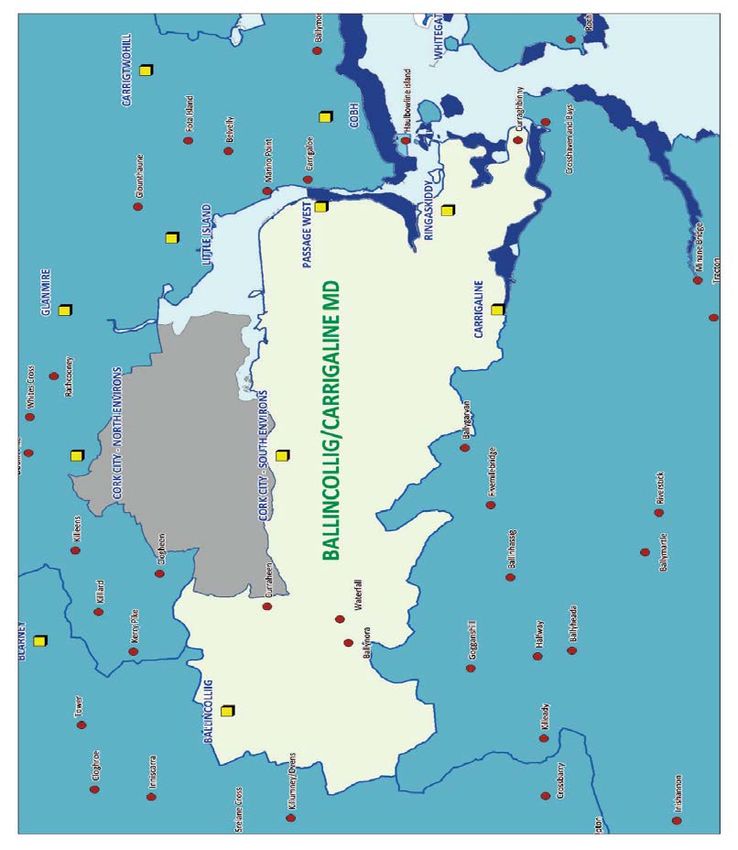
County Development Plan 2014 and comply with the Local Area Plan Guidelines for PlanningAuthorities prepared by the Department of Housing, Planning and Local Government and various legislative and other policy documents issued by the Government. 2.2.4 The Proposed amendment must similarly be consistent with the foregoing. 2.3 Proposed Amendment to the Local Area Plan Strategy Overview 2.3.1 The former Ballincollig Carrigaline Municipal District is located to the south of Cork City and in 2011 the population of the area stood at 71,946. This population is spread across a network of suburbs/settlements in particular the Cork City South Environs, 3 Main Towns, 5 smaller settlements and the open countryside. The district is largely urban based with over 91% of the population living in the Cork City South environs and3 Main Towns, 0.3% living in smaller settlements and just over 8% living in the open countryside i.e. not within a settlement. 2.3.2 Cork City South Environs is the largest urban area within the former Municipal District with a population of 32,635 in 2011. The other urban areas are the Main Towns of Ballincollig, 17,368, Carrigaline (North), 9,917 and Passage West 5,790.
Figure 2.1: Ballincollig Carrigaline Municipal District Settlements

2.4 Contents of the Proposed Amendment
2.4.1 The Draft Local Area Plan provides a blueprint for the development of the Ballincollig
   Carrigaline Municipal District for the next 6 years. Set out below are details of the structure and
   broad chapter content of the Draft local Area Plan.

    Section 1 Introduction
This Section sets out the intention of Cork City Council to amend the Ballincollig Carrigaline Municipal
District Local Area Plan 2017 under Section 13 of the Planning and Development Act, 2000 (as
amended) and Section 30. 4 (b) of the Local Government Act 2019. The purpose of the proposed
amendment is mainly to facilitate residential development in an area of high housing demand The
proposed alteration consists of material changes to the Ballincollig Carrigaline Municipal District Local
Area Plan 2017.

    Section 2 Site Context
2.4.2 This section set out the Site context and outlines the neighbouring land uses in the vicinity of
   the site.

    Section 3 Strategic Planning Context
2.4.3 The purpose of this section is to detail the relevant policies, legislations and major land use
   proposals against which the Proposed Amendment has been benchmarked.
2.4.4     These include
         •    The National Planning Framework

         •    The Southern Regional Spatial and Economic Strategy
         •    Cork Metropolitan Transport Strategy

         •    The Cork County Development Plan 2014 as amended
         •    Ballincollig Carrigaline MD Local Area Plan
         •    The proposed M28 Motorway

Section 4 Reasons for Rezoning Proposal
2.4.5 This section sets out the reasons for considering the proposed amendment which will
   facilitate rezoning at this location

Section 5: Changes to the Ballincollig Carrigaline MD LAP 2017 arising from
Amendment No 1
2.4.6 This section details the textual and mapping changes required to facilitate the proposed Amendment. Section 6; Conclusion 2.4.7 This section provides the justifications for the proposed Amendment and why a potential rezoning at this location is in accordance with the proper planning and sustainable development of the area. 2.5 Relationship to other plans National Policy 2.5.1 National Planning Framework: The NPF is a 20-year high level strategy to guide development and investment in Ireland. The vision, as set out in the NPF, is the delivery of a regional focused strategy for managing growth and providing a counterbalance to the established concentration of growth in the Greater Dublin Area. To achieve this the NPF targets a level of growth for the other regions which combined will at least match the growth of Dublin and the East and Midlands Region. It also supports ambitious growth targets to enable the cities of Cork, Limerick, Galway and Waterford to grow by at least 50% by 2040 and sees them as drivers of regional growth. 2.5.2 The NPF identifies ten National Strategic Outcomes which will be a central consideration in shaping the new City Development Plan. The outcomes will be realised a series o National Policy Objectives (NPOs) which the City Development Plan will have to be consistent with. The NPF is underpinned by the National Development Plan which is a 10-year strategy for public capital investment. 2.5.3 Compact Growth is the first National Strategic Outcome (NSO) and it has particular significance for spatial planning policy, requiring at least 50% of growth in Cork City to be locate within and close to the existing ’built-up’ area. This will allow better use of underutilised land and buildings including infill and brownfield land, with higher housing and employment densities. Higher densities and compact development will need to be accompanied by improved employment opportunities, amenities, health, education and environmental services, supported by sustainable mobility, reflecting NSOs 4,5, and10. NSO 7 promotes enhancement of our natural and built heritage will help retain the unique character of our city 2.5.4 Food Harvest 2020– A Vision for Irish Agri-Food and Fisheries: The agri-food and fisheries sector is Ireland’s most important indigenous industry and is recognised as having a key role to play in Ireland’s export-led economic recovery. With €7bn in exports the sector currently accounts for over half of manufacturing exports, by Irish owned firms. The geographical distribution of the sector ensures that any future wealth and employment generated will be of direct benefit to rural and coastal communities. The 2020 vision for the sector seeks to increase the value of primary output in the agriculture, fisheries and forestry sector by €1.5 billion by 2020 (an increase of 33% on 2007-2009 levels); increase value added in the agri-food, fisheries and wood products sector by €3 billion (+40%) and achieve an export target of €12 billion for the sector (+ 42%). Meeting these targets will have significant environmental challenges including reducing the carbon intensity of Irish agriculture and ensuring the sector plays its part in reducing our overall greenhouse gas (GHG) emissions. As a County with a strong agri-food and fisheries sector already, there is obvious scope of sustainable growth in this area which should bring many benefits to the County as a whole. 2.5.5 National Climate Change Strategy (2007 – 2012) / Climate Change Adaption Framework 2012: The National Climate Change Strategy 2007 – 2012 sets out a range of measures, building on those already in place under the first National Climate Change Strategy (2000) to ensure Ireland reaches
its target under the Kyoto Protocol. The Strategy provides a framework for action to reduce
   Ireland's greenhouse gas emissions.
2.5.6 Ireland is now subject to greater target and ambitions in the effort to combat Climate
   Change, revised legislation is currently making its make through the Legislature and it is
   anticipated that a new or revised National Climate Change Strategy will emerge in due course.
2.5.7 The National Climate Change Adaptation Framework introduces an integrated policy
   framework, involving all stakeholders on all institutional levels to ensure adaptation measures are
   taken across different sectors and levels of government to manage and reduce Ireland's
   vulnerability to the negative impacts of climate change. Under the Framework, the relevant
   Government Departments, Agencies and local authorities have been asked to commence the
   preparation of sectoral and local adaptation plans and to publish drafts of these plans by mid-2014
2.5.8 National Renewable Energy Action Plan: The National Renewable Energy Action Plan (NREAP)
   sets out the Government’s strategic approach and concrete measures to deliver on Ireland’s 16%
   target under European Renewable Energy Directive 2009/28/EC. The development of renewable
   energy is central to overall energy policy in Ireland. Nationally, the Government’s ambitions for
   renewable energy and the related national targets are fully commensurate with the European
   Union’s energy policy objectives and the targets addressed to Ireland under the Renewable Energy
   Directive. Ireland’s energy efficiency ambitions (20% of energy from renewable sources by 2020)
   as set out in the National Energy Efficiency Action Plan are duly reflected in the NREAP.
2.5.9 National Biodiversity Plan: Action for Biodiversity 2011 – 2016: Ireland’s second National
   Biodiversity Plan sets out a vision for the conservation and restoration of biodiversity and
   ecosystems in Ireland and includes the overarching target of “reducing biodiversity loss and
   degradation of ecosystems in Ireland by 2016, and achieving substantial recovery by 2020”. The
   Plan sets out a number of strategic objectives and actions which are aimed at mainstreaming
   biodiversity in the decision-making process across all sectors, strengthening the knowledge base
   and increasing awareness of biodiversity in order to support the achievement of the target.
2.5.10 Our Sustainable Future -A framework for Sustainable Development in Ireland (2012): This
   framework recognises that the green economy and sustainable development agendas are a key
   element of Ireland’s economic recovery strategy and sets out the range of environmental,
   economic and social measures required to move these agendas forward. The framework sets out
   70 measures that will ensure we improve our quality of life for current and future generations and
   sets out clear measures, responsibilities and timelines in an implementation plan. These include
   areas such as the sustainability of public finances and economic resilience, natural resources,
   agriculture, climate change, transport, sustainable communities and spatial planning, public
   health, education, innovation and research, skills and training, and global poverty. The framework
   recognises that some aspects of the pattern of development that emerged in Ireland over the last
   decade present major challenges from a sustainable development perspective and spatial planning
   is one of the mechanisms, along with wider public policy coordination and fiscal policy, to effect
   change at national, regional and local level and deliver more sustainable communities.
2.5.11 Smarter Travel. A new transport Policy for Ireland 2009-2020: Smarter Travel recognises that
   transport and travel trends in Ireland are unsustainable. Even with the investment in Transport 21,
   if we continue with present policies, congestion will get worse, transport emissions will continue to
   grow, economic competitiveness will suffer and quality of life will decline. Smarter travel is
   designed to show how we can reverse current unsustainable transport and travel patterns and
   reduce the health and environmental impacts of current trends and improve our quality of life.
   Actions are aimed at influencing overall travel demand and reducing emissions in both urban and
   rural areas. Key actions include the following:
•       Actions to reduce distance travelled by private car and encourage smarter travel,
                including focusing population growth in areas of employment and to encourage
                people to live in close proximity to places of employment and the use of pricing
                mechanisms or fiscal measures to encourage behavioral change,
        •       Actions aimed at ensuring that alternatives to the car are more widely available,
                through improved public transport service and investment in cycling and walking,
        •       Actions aimed at improving the fuel efficiency of motorised transport, and
        •       Actions aimed at strengthening institutional arrangements to deliver the targets.
2.5.12 National Action Plan for Social Inclusion 2007 – 2016: This National Action Plan for Social
   inclusion, complemented by the social inclusion elements of the National Development Plan 2007-
   2013: Transforming Ireland– A Better Quality of Life for All, sets out how the social inclusion
   strategy will be achieved over the period 2007-2016. The overall goal of this Plan is to reduce the
   number of those experiencing consistent poverty to between 2% and 0% by 2012, with the aim of
   eliminating consistent poverty by 2016.
2.5.13 National Heritage Plan 2002: The National Heritage Plan sets out a clear and coherent
   strategy and framework for the protection and enhancement of Ireland’s national heritage. The
   core objective of the Plan is to protect the national heritage as well as promoting it as a resource
   to be enjoyed by all.

   Regional Policy
2.5.14 Regional Spatial & Economic Strategy: The RSES is a strategic regional development
   framework supporting the programme for change set out in Project Ireland 2040. As the regional
   tier of the national planning process it ensures coordination between the National Planning
   Framework and the City Development Plan. The central themes of the RSES are place making,
   climate action and sustainable economic opportunity and growth. It states: ‘Our cities are the
   pillars on which to base the RSES settlement and economic strategy’.
2.5.15 The RSES sets out a settlement hierarchy for the region and population targets for Cork and
   the other cities to 2026 and 2031. It contains a large number of Regional Policy Objectives (RPOs)
   which the City Development Plan will aim to achieve. The RSES also identifies key enablers, similar
   to those in the NPF, that are designed to underpin Cork City as the primary urban centre of the
   region. Importantly RSES supports Cork City’s ambition to develop as a city of international scale.
   The RSES reinforces the National Strategic Outcome of high quality international connectivity
   through supporting investment and increased capacity in the regions ports and airports and
   provision of high quality digital connectivity It supports the TEN-T network and the continued
   capital investment proposed in the and Port of Cork’s Strategic Development Plan including
   redevelopment of existing facilities in Ringaskiddy and preparing City Docks and Tivoli Docks for
   regeneration. It also supports Cork airport as one the regions two international airports.
2.5.16 Cork Metropolitan Area Strategic Plan (MASP) Volume 2 of the RSES contains the Cork MASP
   which sets out principles and policy objectives to guide investment and sustainable development
   across the entire metropolitan area. The NPF states that Cork requires significantly accelerated
   and urban focused growth to more fully achieve its role as an international centre of scale to
   complement Dublin. The MASP reinforces this and states that the level of growth envisaged for
   Cork (Cork City to grow 50-60% by 2040 to 336,000 people uniquely positions the Cork
   Metropolitan Area as:

       •    A principal complementary location to Dublin with a strong international role;
       •    A primary driver of economic and population growth in the region;
• A compact region with increased regional connectivity; and
• A city region focusing growth on the delivery of sustainable transport patterns
2.5.17 The MASP population targets for the overall Cork Metropolitan Area envisage a growth of
104,657 people by 2031. Most of this growth will occur in Cork City, which would see an uplift in
population of up to 75,000 people, to give a total of 289,000 people in Cork City by 2031. This will
require commensurate growth in employment with close to 65,000 extra jobs needed in the Cork
Metropolitan Area.
2.5.18 The MASP recognises that the concentration of this level of growth in Cork will require
significant and concentrated investment in supporting infrastructure to deliver the houses, jobs
and services required to meet the role and targets set out for Cork. It includes a range of specific
objectives to deliver transport, environmental services, energy, flood protection, cultural, and
amenity infrastructure, among others, which will be incorporated into the Development Plan.
2.5.19 River Basin Management Plan for Ireland This s River Basin Management Plan (RBMP) outlines
the new approach that Ireland will take as it works to protect its rivers, lakes, estuaries and coastal
waters over the next four years. Building on the lessons learned from the first river basin
management planning cycle which were divided into regions, the Government is now planning on
the basis that Ireland is defined as a single River Basin District. The new Plan uses a much-
improved evidence base to underpin decision-making, at both national and local levels. This Plan
also benefits from a stronger and more integrated approach to public consultation and
engagement. The Government is introducing new initiatives and policies to address many of our
water-quality challenges. The Plan builds on the measures implemented during the first planning
cycle, but also seeks to implement supporting measures on a prioritised basis, where necessary.
2.5.20 Southern Regional Waste Management Plan: The Waste Management Plan for the Southern
Region is the framework for the prevention and management of wastes in a safe and sustainable
manner. The scope of the waste plan is broad and ultimately it needs to provide policy direction,
setting out what we want to achieve and a roadmap of actions to get us there. The waste
management plan is a statutory document prepared by the local authorities of the region. This
waste plan covers the period from 2015 to 2021 and is required to be revised or replaced every six
years. The preparation period for the plan extended over 18 months and afforded the local
authorities an opportunity to take stock and evaluate the ways in which wastes have been
managed in the region. This process allowed the authorities to identify measures which are
succeeding and those which are not delivering the desired result The outcome has led to the
formulation of new policies and measures to improve the way wastes are prevented and managed
in the region, while also introducing new steps to help realise the full potential of our waste as a
resource.
2.5.21 Cork County Development Plan 2014: The Cork County Development Plan, 2014 adopted on
the 8th December 2014 sets out the blueprint for the development of the county, underpinned by
the core principles of sustainability, social inclusion, quality of design and climate change
adaptation. The County Development Plan includes over 200 objectives on a range of issues
including:
• Housing,
• Rural, Coastal and Island Development;
• Social and Community facilities;
• Economy and Employment;
• Town Centres and Retail Development;• Tourism;
• Energy and Digital Economy;
• Transport and Mobility;
• Water Services, Surface Water (including Flooding) and Waste;
• Heritage;
• Green Infrastructure and Environment;
• Zoning and Land use.
2.5.22 The objectives of the County Development Plan have not been repeated in the Local Area
Plan therefore the two documents must be read together when planning a development. All
proposals for development, put forward in accordance with the provisions of this Local Area Plan,
must currently demonstrate compliance with the objectives of the County Plan.
2.5.23 It is expected to remain in force (subject to any interim variations that Cork City or County
Councils may make) until late 2020. It is a six year development plan for the County and former
County Areas now under the jurisdiction of Cork City Council The plan also sets out the overall
planning and sustainable development strategy for the county which must be consistent with the
National Spatial Strategy 2002-2020 and the South West Regional Planning Guidelines 2010-2022.
2.5.24 The Plan is currently the principle strategic planning policy document in the subject area and .
Detailed land-use zoning maps for the City South Environs are contained in the Ballincollig
Carrigaline Municipal District Local Area Plan 2017.
2.5.25 Cork City Development Plan 2015-2021: The city plan which is currently under review of
relevance due to the City Boundary Extension in 2019, additionally Cork City is the main economic
and retail focus for the City South Environs and the focus of public transport services within the
metropolitan area. The Plan includes a population target for the city of 150,000 by 2022 and re-
emphasises the potential for the development of brownfield land in the City Centre, Docklands,
Mahon and Blackpool to cater for the sustainable growth of the city. With the adoption of the
National Planning Framework in 2018, these figures have now been superseded with a much more
significant population target allocated to Cork City & Suburbs.
2.5.26 Cork City Heritage Plan 2015-2020, this plan identifies key actions for natural heritage and the
actions from the Cork City Biodiversity Plan has been incorporated into the Cork City Heritage Plan
2015-2020.
2.5.27 County Biodiversity Action Plan 2009-2014: This plan addressed how the wildlife resources of
the County, including native plants, animals and the ecosystems that they combine to produce, will
be managed and protected. Its implementation will contribute to achieving national and
international targets for the conservation of biodiversity in the context of constantly accelerating
rates of species extinction and habitat loss and deterioration globally.
Legislative Context
2.5.28 The Directive 2001/42/EC of the European Parliament and of the Council on the assessment
of the effects of certain plans and programmes on the environment (the SEA Directive) and its
transposed Irish legislation, including amendments form the legislative framework for the SEA
process, including its documentation in the form of an Environmental Report. The Planning and
Development Act, 2000 (as amended) also forms an integral part of SEA and additional guidance
from a European context and national context has been listed within this Section. Additional keypieces of legislation pertaining to environmental considerations include the following list which is
regarded as not exhaustive:
• EU Birds Directive (79/409/EEC)
• EU Habitats Directive (92/43/EEC)
• The Wildlife Act, 1976 (as amended)
• The Flora (Protection) Order 1999
• UN Convention of Biological Diversity 1992 (ratified 1996)
• Convention on Wetlands of International Importance (Ramsar Convention 1971)
• European Communities (Birds and Natural Habitats) Regulations, 2011
• Urban Waste Water Treatment Regulations, 2001 and 2004 and Amendments (2010)
• Water Services Act, 2007
• Water Services (Amendment) Act, 2013
• European Communities Environmental Objectives (Surface Waters) Regulations, 2009
• European Communities Environmental Objectives (Freshwater Pearl Mussel)
Regulations, 2009
• European Communities Environmental Objectives (Groundwater) Regulations, 2010
• EU Nitrates Directive (91/676/EEC)
• European Communities (Good Agricultural Practice for Protection of Waters)
Regulations, 2010
• EU Bathing Water Directive (2006/7/EC)
• Bathing Water Quality Regulations, 2008
• Bathing Water Quality (Amendment) Regulations, 2011
• Shellfish Waters Directive (2006/113/EC)
• European Communities (Quality of Shellfish Waters) Regulations, 2006
• European Communities (Quality of Shellfish Waters) (Amendment) Regulations, 2009
• Waste Water Discharge (Authorisation) Regulations, 2007
• European Communities (Environmental Liability) Regulations, 2008
• Air Quality Standards Regulations, 2011
• Environmental Noise Regulations, 2006
• The European Landscape Convention, 2000
3 Environmental Baseline3.1 Introduction
3.1.1 The environmental baseline of the former Municipal District is described in this section. This
baseline information outlines the environmental context within which Proposed Amendment No 1
to the Ballincollig Carrigaline Municipal District Local Area Plan will operate. The purpose of this
section is to provide enough environmental baseline data to:
• support the identification of environmental problems;
• support the process of assessing the environmental effects;
• provide a baseline against which future monitoring data can be compared.
3.1.2 A number of key environmental issues set the context for the collection of the baseline data
and each section includes an overview of the current situation, the key environmental problems
and an analysis of the likely evolution in the absence of the Draft Plan. The Environmental issues
are listed below:
• Population and Human Health,
• Biodiversity – Flora and Fauna,
• Soil,
• Water,
• Air and Climatic factors,
• Material Assets,
• Cultural Heritage,
• Landscape.
3.1.3 The Department of the Environment, Heritage and Local Government (DoEHLG) circular SEA
1/8 and NPWS 1/8 requires that under the Habitats Directive an Appropriate Assessment of the
ecological implications of the amendment is conducted. An appropriate assessment screening of
the Proposed Amendment was conducted by Cork City Council and is provided as part of this
Proposed Amendment.
3.2 Population and Human Health
3.2.1 In 2011 the population of the Cork City South Environs stood at 32,635In the period to 2022,
the population target allocated by the Cork County Development Plan 2014 provides for the
population to fall by 1,327 persons or 3.8 % approximately. However, these figures are now
obsolete having been superseded by revised population and housing targets for Cork City &
Suburbs as prescribed in the National Planning Framework.
3.2.2 With regard to Human Health, impacts relevant to SEA are those which arise as a result of
interactions with environmental vectors such as air, water or soil through which contaminants or
pollutants, which have the potential to cause harm, can be transported so they come in contact
with human beings. These issues will be explored in the Environmental Report.
Existing Sensitivities in relation to Population and Human Health3.2.3 The National Planning Framework has made provision for the population of Cork City &
Suburbs to increase leading to increased demand for housing within the area and the provision of
supporting social, community and employment/commercial services, facilities and opportunities.
The timely delivery of such services is important to the quality of life of the population.
3.2.4 Enabling population growth and sustainable patterns of development in key settlements may
be hindered by delays in the delivery of key infrastructure required to facilitate development
leading to a housing shortage in some areas and development being shifted to other, potentially
less sustainable locations, frustrating efforts to plan for having people, jobs and services located
closer together.
3.2.5 Dispersed settlement patterns can lead to an over dependence on car-based transport and
long journeys to work which can have negative impacts on the health of the population and quality
of life.
3.2.6 The economic decline of some settlements and/or the failure of others to realise the
expected level of growth, can lead to reduced service provision, loss of job opportunities and
reduced quality of life for the remaining residents of the area. A key challenge for the new City
Plan which apply in this area is to promote the sustainable growth of the economy of all districts
and City towns and to support the balanced socio-economic growth of our city.
3.2.7 Improved recreational/walking and cycling facilities are needed to support an increased
uptake in physical exercise to help improve / maintain the health of the population. This
amendment will facilitate this as it provides for a vital section of the Ballybrack Cycleway, a key
element of the Cork Cycle Network Plan.
3.3 Biodiversity-Flora and Fauna
3.3.1 European and National Legislation now protect the most valuable of our remaining wild
places, through designation of sites as proposed Natural Heritage Area, Natural Heritage Areas,
candidate Special Areas of Conservation and Special Protection Areas. The designation of these
sites at a national level is the responsibility of the Department of the Environment, Heritage and
local Government but it is the responsibility of all of us to protect these sites. The process of
designation of such sites is ongoing, with new sites being added, re-designated and boundaries of
existing sites being adjusted. The key Natura sites in the former Ballincollig Carrigaline MD are
outlined in Tables 1,2 and 3 below.
3.3.2 There is one SPA, one SAC and five pNHA’s dispersed throughout the Ballincollig Carrigaline
MD. The reasons for designation range from ecological, plants, ornithological, woodland, heath,
bats and vegetation. The largest nature conservation area is the Cork Harbour SPA (4030). The four
pNHAs include Douglas River Estuary pNHA1046, Monkstown Creek pNHA1979, Loughbeg
pNHA1066 and Owenboy River pNHA1990.
Table 1: Special Protection Areas
Name Environmental Designation Settlement
Cork Harbour SPA 4030 Douglas, Ringaskiddy,
Rochestown, Monkstown,
Passage West, Glenbrook
Table 2 Special Areas of ConservationName Environmental Designation Settlement
Cork Harbour Great Island SAC 1058 Douglas, Ringaskiddy,
Channel Rochestown, Monkstown,
Passage West, Glenbrook
Table 3: Natural Heritage Areas
Name Environmental Designation Settlement
Ballincollig Cave pNHA 1249 Ballincollig
Douglas River Estuary pNHA 1046 Douglas
Monkstown Creek pNHA 1979 Ringaskiddy
Loughbeg pNHA 1066 Ringaskiddy
Owenboy River pNHA 1990 Carrigaline
Protected Species
3.3.3 Cork Harbour is a large, sheltered bay system with several river estuaries – principally those
of the Rivers Lee, Douglas and Owenacurra. The SPA site comprises most of the arterial areas of
Cork Harbour, including all of the North Channel, the Douglas Estuary, Inner Lough Mahon. Lough
Beg, Whitegate Bay and Rostellan inlet. Cork Harbour is an internationally important wetland site,
regularly supporting in excess of 20,000 wintering waterfowl, for which it is amongst the top five
sites in the country. Several of the species which occur regularly are listed in Annex 1 of the EU
Birds Directive, i.e. whooper swan, Golden Plover, Bar-tailed Godwit, Ruff and Common Term.
Existing Sensitivities in relation to Biodiversity
3.3.4 The Proposed Amendment will make provision for the population of the City South Environs
to increase leading to increased demand for housing within the area and the provision of
supporting social, community and employment / commercial services, facilities and opportunities.
The timely delivery of such services is important to the quality of life of the population.
3.3.5 Enabling population growth and sustainable patterns of development in key settlements may
be hindered by delays in the delivery of key infrastructure required to facilitate development
leading to a housing shortage in some areas and development being shifted to other, potentially
less sustainable locations, frustrating efforts to plan for having people, jobs and services located
closer together.
3.3.6 Dispersed settlement patterns can lead to an over dependence on car-based transport and
long journeys to work which can have negative impacts on the health of the population and quality
of life.
3.3.7 The economic decline of some settlements and / or the failure of others to realise the
expected level of growth, can lead to reduced service provision, loss of job opportunities and
reduced quality of life for the remaining residents of the area. A key challenge for the new plan is
to promote the sustainable growth of the economy of the three main towns of the Municipal
District to support the balanced socio- economic growth of the area.
3.3.8 Improved recreational/walking and cycling facilities are needed to support an increased
uptake in physical exercise to help improve / maintain the health of the population.
3.3.9 At present water quality issues within Cork Harbour, which is a designated Special Area of
Conservation and Special Protection Area, mean that development within the catchment is on holdpending resolution of the water quality issues. This will affect development within the Fermoy
Municipal District.
3.3.10 New development has the potential to impact on has biodiversity, flora and fauna through
the loss of some greenfield land, habitat loss or disturbance, contribution to climate change and
impacts on water quality.
3.3.11 Cork City Council is commissioning a baseline ecological status report for some areas which
will help inform the development of the City Development and minimise the loss of ecological
resources.
3.4 Soils
3.4.1 The SEA examined soil issues within the Municipal District, looking at the most common soil
types within the plan area and how they might be affected by the development proposed in the
Draft Plan. The SEA considered the challenges facing soil generally together with issues such as
erosion, geology and quarrying as appropriate.
3.4.2 The most dominant soil types in Cork City South Environs are Brown podzolic and Grey Brown
Podzolic which are medium to heavy texture with a great depth of profile. Brown podzolic display
good physical characteristics and are usually devoted to cropping and pasture production, while
Grey Brown podzolic are good all purpose soils.
Table 4 Ballincollig Carrigaline MD Soil Types
Rolling Lowland Brown podzolic 60% Acid Brown earths Old Red sandstone,
Less depleted of 40% Lower avonian shale
nutrients Most occur on lime and Ryolite glacial till.
deficient parent
materials, therefore
acidic in nature,
relatively mature and
well drained
Existing Sensitivities in relation to Soil
4.5.3 Additional development may lead to damage to or loss of the soil resource or impact on its
functions.
3.5 Water
3.5.1 This section of the SEA will consider issues in relation surface water (rivers and lakes,
estuarine and coastal waters) and groundwater in the Municipal District as it relates to Cork City
South Environs, looking at the status and quality of these waters. The section will also examine
water services infrastructure (drinking water supply, wastewater treatment and storm water).
3.5.2 Consideration was given to current and future loading within key water catchments, the
potential impacts of additional development on water quality, surface water management, climate
change and the need for new infrastructure to serve anticipated demands.
3.5.3 Water services of the all the infrastructure requirements needed to facilitate new
development is the most critical, as in the absence of it, no development can take place. SinceJanuary 2014 Irish Water is responsible for the operation of public water services (drinking water and wastewater) including management and maintenance of existing water services assets. Those intending to carry out development must now obtain consent to connect to Irish Water Infrastructure for new development. Irish Water also has responsibility for planning for future infrastructure needs and for the delivery of new infrastructure and future decisions in relation to investment in new water services infrastructure will be made by Irish Water. Developers must also satisfy themselves that Irish Water will make adequate services available in order to meet the needs of any development they propose. 3.5.4 The Cork City Development Plan 2015, the Cork County Development Plan 2014 and Proposed Amendment No 1 to the Municipal District Local Area Plans are important documents that Irish Water should take into account in formulating its plans and programmes. . Existing Sensitivities in relation to Water 3.5.5 The major issues arising in relation to water relates to the wider Cork City Area, where this currently deficiencies in relation to Wastewater services, although it is considered that there is sufficient capacity to cater for the Proposed Amendment. 3.5.6 There is currently sufficient drinking water capacity in the City South Environs to cater for some of the proposed amendment subject to private investment by the landowners in co- operation with Irish Water. 3.5.7 . Additional investment will be required in the City South Environs in order to facilitate development in line with the projections of the National Planning Framework Flooding 3.5.8 The assessment and management of flood risks in relation to planned future development is an important element of the proposed Amendment Cork City South Environs has a number of rivers or streams either running through the built-up area or close by and are inevitably exposed to some degree of flood risk when those rivers or streams overflow their normal course. Similarly, in coastal areas flooding can periodically occur following unusual weather or tidal events. 3.5.9 Flood maps have been prepared in association with the OPW and the these maps available to the public. 3.5.10 In the course of preparing this amendment, the land under active consideration for ‘zoning’ for future development was assessed in accordance with the Flood Risk Management Guidelines. No flood risk is indicated on the subject site. 3.5.11 A detailed Strategic Flood Risk Assessment is set out in Appendix A of this document. 3.6 Air and Climatic Factors 3.6.1 The SEA for the Proposed Amendment considered Air and Climatic Factors potentially affecting the plan area including air quality, noise, greenhouse gases etc. 3.6.2 Air quality is generally good in the City South Environs and Cork City is located in an area with a relatively mild climate and has an almost continuous movement of clean air. Nationally, it is now
evident that, due mainly to the very significant increase of vehicles on the public roads, the biggest
   threat now facing air quality in urban areas is emissions from road traffic. As the population grows
   and more development takes place emissions will rise.
3.6.3 Cork City and County Councils have prepared a joint Noise Action Plan which deals with the
   mitigation of noise within the Cork conurbation as well as along all national and some regional
   roads within the county. Common sources of noise within the City include road vehicles, aircraft,
   railways, industry, construction, commercial premises and entertainment venues, sports and
   recreation venues and windfarms.
3.6.4 Land Use Plans have an important role to play in the prevention and limitation of adverse
   noise effects and can ensure that conflicts do not occur between noise-generating and noise
   sensitive uses such as housing, hospitals, schools, places of worship etc., by guiding development
   to the right locations and where necessary, specifying design and layout solutions, planning
   authorities can limit the overall number of people exposed to potential noise effects.

Existing Sensitivities in relation to Air and Climate
3.6.5 One of the key manifestations of climate change is flooding. Cork City Council has a body of
   information in relation to the areas that are at risk of flooding and will test the outputs of the
   proposed Amendment against that information as part of the Strategic Flood Risk Assessment of
   the new plan., see Appendix A
3.6.6 The sprawling nature of the settlement of Cork City Environs results in high levels of car-
   based commuting which contributes to the overall transport emissions which impacts on air
   quality.

3.7 Material Assets
3.7.1 The EPA SEA Process Draft Checklist (2008) defines material assets as the critical
   infrastructure essential for the functioning of society such as: electricity generation and
   distribution, water supply, wastewater treatment, transportation, etc. Water Supplies and
   Wastewater Treatment infrastructure will be dealt with under Water in Section 3.5. This section of
   the SEA will deal with other essential infrastructure within the plan area i.e. Transport (Road, Rail,
   Public Transport, airports, ports/ harbours) etc as appropriate and Waste.

Existing Sensitivities in relation to Material Assets
3.7.2 Additional population and economic growth in the area is dependent on the provision of
   appropriate and sustainable water services and transport infrastructure to underpin sustainable
   growth. The Amendment has identified areas where additional investment is proposed through
   the Cork Metropolitan Area Transport Study ( CMATS), particularly in the area of transport in order
   to meet population growth targets.

3.8 Cultural Heritage
3.8.1 The SEA will consider Archaeological and Architectural Heritage. The City South Environs has a
   vast resource of archaeological heritage with over 19 monuments registered throughout the
   settlement.
3.8.2 Cork City has a wealth of industrial archaeology and this is protected through the
   archaeological record.
You can also read