City of Shelbyville Recreation Zone Improvement Plan 2019-2028
←
→
Page content transcription
If your browser does not render page correctly, please read the page content below
A Zone Improvement Plan for Parks & Recreation Facilities
City of Shelbyville – Parks & Recreation Department

The proposed:

City of Shelbyville Recreation Zone
Improvement Plan 2019-2028

For:
City Parks & Recreation Facilities

Prepared for:
City of Shelbyville Park Board
City of Shelbyville Plan Commission
City of Shelbyville City Council
Shelbyville, Indiana

Prepared by:
Lehman & Lehman, Inc.
Landscape Architects | Planners | Placemakers
Mishawaka, Indiana

With Review by:
Matt House, P.E.
Professional Engineer
City of Shelbyville

February 2019
Shelbyville Recreation Zone Improvement Plan Study

○

The proposed:

City of Shelbyville Recreation Zone
Improvement Plan 2019-2028

This report was prepared under contract for the
City of Shelbyville by:

         Charles F. Lehman, ASLA, FRSA
         President, Lehman & Lehman, Inc.
         Landscape Architects | Planners | Placemakers
         510 Lincolnway East, Suite C                                             Transforming Horizons
         Mishawaka, Indiana 46544

         With Review by:
         Matt House, P.E.,
         Professional Engineer, City of Shelbyville

         Completed February 2019

The information, analysis, ideas, designs and concepts contained herein are the exclusive intellectual property of
Lehman & Lehman, Inc. Except as it is used by the City of Shelbyville in direct relation to the study’s
implementation, no part of this publication may be reproduced or used in any way without expressed written
permission by Lehman & Lehman, Inc. All rights reserved.
Copyright © 2019 – LEHMAN & LEHMAN, INC.

Shelbyville Recreation Zone Improvement Plan                          Copyright © 2019 – Lehman & Lehman, Inc.   Page 2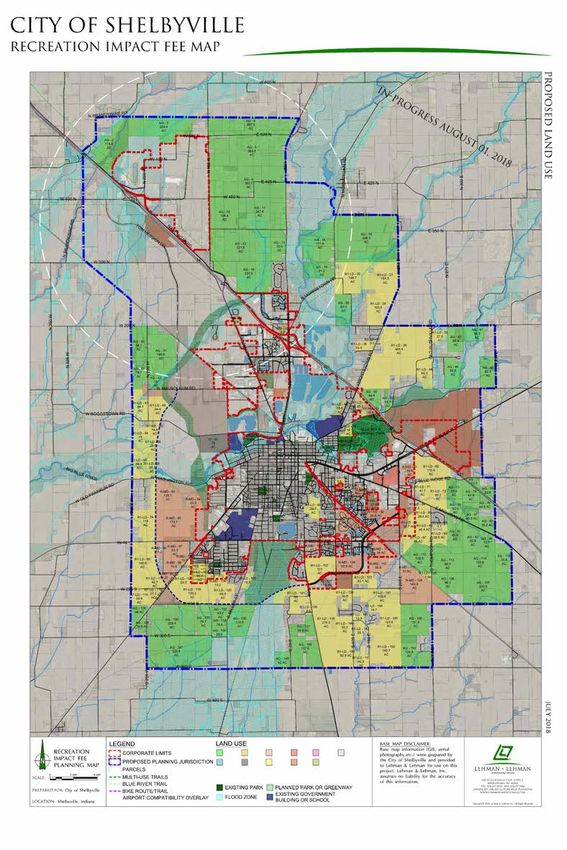
Shelbyville Recreation Zone Improvement Plan Study

February 2019

In 1991, the Indiana General Assembly passed an impact fee bill that
created an alternative funding mechanism for infrastructure improvements
in fast growing areas. The essence of the legislation was to allow local
governments the option of passing onto new residents the cost of building
the new infrastructure demanded by those same new residents.
This will be the initial Infrastructure Improvement Plan for Parks and Recreation Facilities (Recreation Impact Fee
Study) for the City of Shelbyville. This study started several months ago, following the process as outlined by the
1991 Indiana Code. A Recreation Impact Fee Advisory Committee was established and worked with the
Consultant in updating the current recreation component inventory along with the related standards and
established a recreation impact zone. Population projections were arrived at by analyzing existing developments
as well as new development parcels of the planning area, related residential building permits were forecasted,
both current and future recreation component deficiencies were calculated, and costs for these infrastructure
deficiency improvements were established for both current (2019) and future (2028) needs. The impact fee for
the impact fee zones were determined by dividing the estimated costs of the 10-year deficiencies by the number
of projected residential building permits of each impact zone during that same period.
According to State Statute, Recreation Impact Fees are collected prior to the issuance of each residential
building permit, and the first collection will occur six (6) months after the final approval by the City Council of the
Impact Fee ordinance. The fees are then placed in an interest bearing account, and related expenses for
improvements are then paid from that account. Since impact fees cannot be used to fund current deficiencies,
those improvements will need to come from other resources of the City. Recreation Impact Fees can only be
used for the costs of the projected 10-year future needs determined by future populations.
An impact fee, by ordinance, may not be collected for more than five years without a review and update of the
Infrastructure Plan and adoption of the fee by the City Council. Attached is the new Infrastructure Improvement
Plan. The City of Shelbyville staff prepared the plan with assistance from Lehman & Lehman, Inc. After
preparation, the plan was submitted to Matt House, P.E. (Shelbyville’s City Engineer), for final review and
comment. The plan establishes new park and recreation standards for Shelbyville and recommends a one-zone
structure and Recreation Impact Fees that will be necessary in order to achieve the City of Shelbyville’s Park and
Recreation standards.
After careful analysis, the Shelbyville Park Infrastructure Advisory Committee and the City of Shelbyville staff feels
that the recommended Recreation Impact Fee of $1,005 is a responsible fee for the recommended standards.
The Shelbyville Park Infrastructure Advisory Committee recommends acceptance of the fee by the Shelbyville
Park Board before being placed before the Shelbyville Planning Commission and City Council for final adoption.
Adoption of these parks and recreation standards will ensure the continued delivery of quality parks and
Recreation services for all of the Citizens of Shelbyville.

Sincerely,

Karen Martin, Director
City of Shelbyville Parks & Recreation

Shelbyville Recreation Zone Improvement Plan                             Copyright © 2019 – Lehman & Lehman, Inc.   Page 3
Shelbyville Recreation Zone Improvement Plan Study

Acknowledgements

City of Shelbyville Park Infrastructure Advisory Committee
    Committee Members:
         •    Gary Bowen, Park Board President
         •    Karen Martin, Director, Park Department
         •    Jennifer Meltzer, City Attorney
         •    Paul Munoz, Developer
         •    Linda West, Real Estate
         •    Jeff Wright, City Council / Park Board Liaison
    Staff and Consultant Members
         •    Karen Martin, Director, Shelbyville Parks & Recreation
         •    Adam Rude, Director, Shelbyville Planning & Building
         •    Matt House, City Engineer, City of Shelbyville
         •    Chuck Lehman, Lehman & Lehman, Inc. (Consultant)

Mayor                                                      Clerk Treasurer
    •    Tom DeBaun                                            •   Frank Zerr

City Council
    •    Rob Nolley, 3rd Ward, President                       •   Jeff Wright, 5th Ward
    •    Joanne Bowen, 1st Ward                                •   Brian Asher, At-Large
    •    David Carmony, 2nd Ward                               •   David Phares, At-Large
    •    Brad Ridgeway, 4th Ward

Park Board
    •    Gary Bowen, President                                 •   Mike Babbitt, Member
    •    Gary Nolley, Vice President                           •   Terie Anderson, Member

Advisory Plan Commission
    •    Mike Evans, President                                 •   Wade Lewis
    •    Doug Cassidy, Vice President                          •   Joanne Bowen
    •    Joe Lux                                               •   Matt House
    •    Barb Lewis                                            •   Gary Nolley

Shelbyville Recreation Zone Improvement Plan                       Copyright © 2019 – Lehman & Lehman, Inc.   Page 4
Shelbyville Recreation Zone Improvement Plan Study

Table of Contents
PREFACE
Cover Letter .......................................................................................................................................................... 3
Acknowledgments ................................................................................................................................................ 4
Table of Contents.................................................................................................................................................. 5
Executive Summary ............................................................................................................................................... 7
Recreation Impact Fee Study Process .................................................................................................................. 11
Population and Residential Development Trends ................................................................................................ 12
Expectations of Population Growth / Residential Building Permit Projections .................................................... 19
Existing Park Land Facilities ................................................................................................................................. 20
Existing Infrastructure of Recreation Facilities ...................................................................................................... 24
Community Level of Service Needs and Cost Estimates ..................................................................................... 28
Recommended Recreation Impact Fee ................................................................................................................ 30
Summary of Impact Fee Study ............................................................................................................................. 38

APPENDIX
Appendix A: Indiana Code (IC) 36-7-4-1300 ........................................................................................................ 42
Appendix B: Fixed Assets / Capital Improvements over the years 2014-2018 .................................................... 61
Appendix C: Summary of Shelbyville Park Department Revenues 2014-2018 .................................................... 62
Appendix D: Impact Fee One Zone Recommendation Logic .............................................................................. 62
Appendix E: Park and Recreation Infrastructure Inventory .................................................................................. 63
Appendix F: Letter of Study Review from Professional Engineer......................................................................... 64

LIST OF TABLES
Table 1 – Shelbyville Potential Residential Growth Work Sheet of Undeveloped Land Parcels .......................... 14
Table 2 – Shelbyville Potential Residential Growth Work Sheet of Existing Developments ................................ 16
Table 3 – Potential Residential Growth Summary ................................................................................................ 17
Table 4 – Current and Projected Population and Building Permit Growth .......................................................... 19
Table 5 – Park Site Inventory ................................................................................................................................ 22
Table 6 – Land Inventory – Current Level of Service and Community Level of Service ....................................... 23
Table 7 – Facilities Inventory and Needs ............................................................................................................. 25
Table 8 – Current Deficiencies and Future Needs .............................................................................................. 26
Table 9 – Acreage Needs for Recreation Components ....................................................................................... 27
Table 10 – Cost of Recreation Components to Overcome Current Deficiencies and Future Needs .................. 28
Table 11 – Recreation Impact Fee Scenarios ....................................................................................................... 29
Table 12 – Recreation Impact Fee Scenario Summary of “A” Priorities .............................................................. 30
Table 13 – Funding Sources for Current Deficiencies .......................................................................................... 30
Table 14 – Forecast Annual Funding for Current Deficiencies ............................................................................. 31
Table 15 – Impact Deduction Calculations .......................................................................................................... 32
Table 16 – Recommended Recreation Impact Fee Calculations ......................................................................... 33
Table 17 – Recreation Impact Fee Revenue 10-Year Projection .......................................................................... 35
Table 18 – Implementation Schedule for Current Deficiencies............................................................................ 37
Table 19 – Implementation Schedule for Future Needs ...................................................................................... 37

Shelbyville Recreation Zone Improvement Plan                                                             Copyright © 2019 – Lehman & Lehman, Inc.                  Page 5
Shelbyville Recreation Zone Improvement Plan Study

LIST OF FIGURES
Figure 1 – Study Area ............................................................................................................................................ 9
Figure 2 – Shelbyville Residential Growth Potential............................................................................................. 13
Figure 3 – Annual Residential Building Permits 2004-2017 ................................................................................. 18
Figure 4 – Historic and Projected Population of the City of Shelbyville .............................................................. 20
Figure 5 – Park Facilities System – City of Shelbyville .......................................................................................... 21
Figure 6 – Recreation Impact Fee Revenues Graph ............................................................................................. 34
Figure 7 – GDP Percentage Change from 2002-2017 ......................................................................................... 35

Shelbyville Recreation Zone Improvement Plan                                                          Copyright © 2019 – Lehman & Lehman, Inc.                Page 6
Shelbyville Recreation Zone Improvement Plan Study

Executive Summary
Background
The City of Shelbyville and its surrounding area has, over the past decades, experienced significant growth in
residential development. As a result, the public infrastructure systems (roads, drainage, water/sanitary utilities
and parks) are, or will become, strained to keep pace with the demands placed on them.
In anticipation of these demands, the City of Shelbyville is in the process of implementing and updating one of
these public infrastructure systems by way of a Recreation Impact Fee Ordinance. The Parks and Recreation
Master Plan Update and the City’s Comprehensive Plan shows that the demand for recreational facilities will
intensify because of the demographics of the growing population base. It is also recognized that a quality system
of parks, green spaces and pathways/trails adds to the economic value and quality of life of the entire
community.
The demands placed on the Park System by rapid growth have, and will, outpace the City’s financial ability to
provide the new and expanded facilities identified in the Parks and Recreation Master Plan. The current revenues
are devoted almost entirely to maintaining and operating existing park facilities and programs. New sources of
capital improvement revenue are needed. The Recreation Impact Fee Ordinance will benefit the City and
community in the future by keeping pace with the population growth while maintaining the level of adopted
recreation standards.
The Plan acknowledges that the 2010 Census data will provide the basis for the data on population and
demographics for the City. The City has provided the Consultant with updated population estimates that were
used as part of this study analysis as well.

History of Recreation Impact Fees
In 1991, the State of Indiana enacted an impact fee statute that allows local communities to collect impact fees
(monetary charges) to pay for, defray or mitigate the capital costs and improvements to infrastructure
necessitated to serve the proposed new development.
The essence of the legislation was to allow local governments the option of passing onto new residents the costs
of building the new infrastructure expected by those same residents.

Impact Fees Facts
Need for and Application of Impact Fees
   • Best applied to Fast Growing Communities (or projected)
   • Considered as an “Entrance Fee” for residents to build and live in the Community
   • Funds are applied directly to the infrastructure needs caused by the growth
Different Types of Development Impact Fees
    • Park/Recreation, Roads, Water/Sanitary Utilities, and Drainage
Impact Fee Studies
   • Cover 10-year projection period
   • Must be updated, at a minimum, every five years
   • Also used to define development standards

Shelbyville Recreation Zone Improvement Plan                            Copyright © 2019 – Lehman & Lehman, Inc.   Page 7
Shelbyville Recreation Zone Improvement Plan Study

Benefits of Recreation Impact Fees
    ¡    Future residents pay for the increased demand on infrastructure services (defined as Community Level of
         Service)
    ¡    Current residents do not bear the burden of infrastructure expansion due to population growth
    ¡    Maintains quality of life as community grows

Development Impact Fees
Development Impact Fees, as described by this Zone
Improvement Plan (herein Plan), will shift part of the
cost of new and expanded park facilities from the
community at large to the new developments that are
generating the need for those new and expanded
facilities. Impact fees, however, cannot be used to
finance the current needs of improvements
required to raise the Current Level of Service to
the Community Level of Service, hereafter referred
to as “deficiencies.”
Impact fee logic has long been debated, discussed and endorsed by those who are involved in public finance. In
1991, the Indiana General Assembly enacted legislation [Indiana Code (IC) 36-7-4-1300] (see Appendix A) that
enables localities to impose Development Impact Fees for certain types of infrastructure improvements,
including park and recreational facilities. Among other things required of the locality, the legislation stipulates
that:
    ¡    An Impact Fee Advisory Committee be appointed
    ¡    An Impact Fee Zone be established
    ¡    A Zone Improvement Plan be prepared
    ¡    An Impact Fee be determined and
    ¡    An Impact Fee Review Board be appointed

Park Infrastructure (Impact Fee) Advisory Committee
The City Administration of Shelbyville appointed a Recreation Impact Fee Advisory Committee in 2018. The
Committee consisted of members of the Park Board, City Council, Real Estate Brokers and Developers. City staff
members of the Planning and Engineering Departments were included in addition to others appointed to fulfill
statutory requirements. The Committee, listed on the acknowledgment page, met on several occasions to
research and review data, to establish standards for park facilities, and to formulate the plan and strategies as
described herein.
Although the City Council has jurisdiction only within the Shelbyville City limits, the Committee concluded early
in its deliberations that the Study Area of this Plan should include all of the Shelbyville Planning Area Boundary
(the same area as encompassed with its Comprehensive Plan) for the following reasons:
     ¡    It is reasonable to expect that some properties adjacent to the current corporate boundaries will
          become part of the City of Shelbyville some in the time frame of this study
     ¡    The City is continuing to grow into the planning area through voluntary annexation, and
     ¡    The City’s entire land use planning area is within the future service area of the City

Shelbyville Recreation Zone Improvement Plan                             Copyright © 2019 – Lehman & Lehman, Inc.   Page 8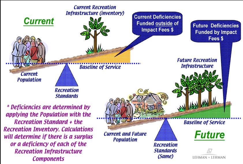
Shelbyville Recreation Zone Improvement Plan Study

Impact Zone
Within the Study Area, the Advisory Committee recommended the establishment of a single (one) Impact Zone
to coincide with the corporate and Comprehensive Planning boundary of the City as it continues to expand in
the future through annexations. Thus, the Impact Zone is expected to expand through annexation until it
encompasses the entire Planning Jurisdiction and future areas of annexation in the Township(s) within the
County. More particular, the Impact Zone boundaries for the City of Shelbyville are co-terminus with the existing
corporate boundaries of the City, as such boundaries may be extended from time to time through annexation,
and over which boundaries the City exercises planning and zoning jurisdiction.
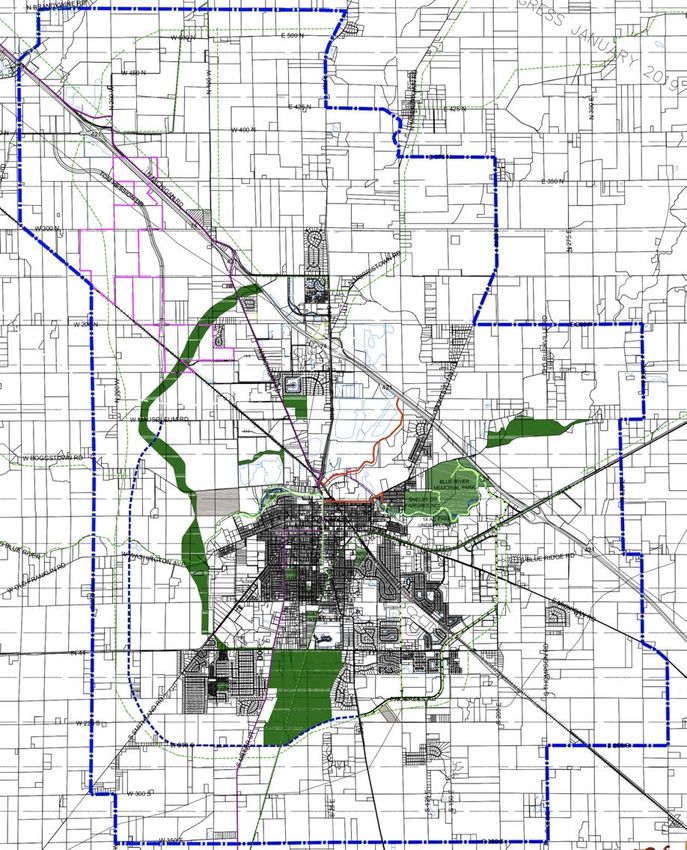
Figure 1 is a map (from the City’s Comprehensive Plan) that shows the Study Area which consists of the City’s
Corporate Boundaries. This area constitutes the boundary of the Impact Fee Zone. This map also illustrates the
projected current city limits, future growth boundaries along with the projected Future Land Uses, transportation
projections, etc. as per the City’s Comprehensive Plan.

                      Figure 1 – Study Area (source: City of Shelbyville’s Comprehensive Plan)

Zone Improvement Plan
The Zone Improvement Plan is described by this document and examines the existing park facilities, and
determines the costs to (A) overcome existing deficiencies and (B) to meet future needs according to Community
Level of Service standards established herein.

Shelbyville Recreation Zone Improvement Plan                          Copyright © 2019 – Lehman & Lehman, Inc.   Page 9
Shelbyville Recreation Zone Improvement Plan Study
                                                                            Recommendation to be determined with
Impact Fee Review Board                                                     feedback from the Advisory Committee
As required by Indiana Code 36-7-4-1338, and before the Impact Fee is implemented, the City will establish an
Impact Fee Review Board, consisting of Shelbyville citizens. The law requires that the Impact Fee Review Board
include one real estate broker and one professional engineer, both licensed in Indiana, and one certified public
accountant.

Other Planning Efforts Acknowledged in this Plan
This Recreational Impact Fee study acknowledges the existing and the progress of the implementation of both
the City’s Comprehensive Plan and Parks and Recreation Master Plan, as constituting the vision for the City and
its park system. The Impact Fee recommended in this Plan is a financial strategy that will help achieve that vision.

Conclusions
     1. The Recreation Impact Fee Advisory Committee recommends to the City of Shelbyville that a new
        Recreation Impact Fee (RIF) Ordinance be adopted instituting a new Recreation Impact Fee of $1,005.
     2. The Advisory Committee felt there should NOT be any annual adjustment (i.e. Gross Domestic Product
        annual figure) factored into the impact fee amount. The Advisory Committee also did NOT recommend
        the application of a Housing Equivalent adjustment. The Advisory Committee noted both of these RIF
        adjustments as part of the study but deferred a decision in applying these adjustments to the Plan
        Commission and/or the City Council.
     3. Following the State Code [IC 36-7-4-1340(a)], RIF collection will start six months after approval of the
        ordinance. The funds collected will be kept in a “Recreation Impact Fee” line item of the City’s
        Accounting Budget.
     4. The City of Shelbyville should establish criteria, as policy, for the acceptance of land donations for park
        use and/or open space. Also, the City of Shelbyville, through its Parks Board, will address, annually, the
        distribution priorities of the RIF revenues.
     5. The City’s Park and Recreation Master Plan Update, will reflect the standards and goals established as
        part of this study.
     6. Collection of the RIF will occur when new residential building permits are pulled. As an option,
        Recreation Impact Fee payments can be established using an installment plan as per IC 36-7-4-1324.
     7. Reporting of RIF’s transactions will be done annually noting recreation impact fees collected and the
        disbursements for recreation infrastructure components used as part of the impact fee calculations used
        during the RIF ordinance period.
     8. A new RIF update study will be considered annually but the update study should begin at the end the
        fourth (4th) year of the RIF ordinance allowing time for there to be a smooth transition between the
        retiring ordinance and the newly adopted ordinance.

Shelbyville Recreation Zone Improvement Plan                           Copyright © 2019 – Lehman & Lehman, Inc.   Page 10
Shelbyville Recreation Zone Improvement Plan Study
Recreation Impact Fee Study Process
The process of defining a Recreation Impact Fee for a community involves a series of steps. Those steps include
the following:
1. Establish the Park Impact Fee Advisory Committee
2. Define the Impact Zone
3. Collect current census populations and trends
4. Inventory the current recreation infrastructure for land and facilities (Current Level of Service)
5. Establish Community Level of Service for recreation land and facilities
6. Analyze housing building permits and trends (both inside City limits and within the planning area)
7. Analyze current deficiencies and 10-year infrastructure needs based on Community Level of Service and
projected population forecasts
8. Determine costs for meeting current deficiencies and future needs based on Community Level of Service
9. Recreation Impact Fees (RIF) = Future Recreation Infrastructure Need Costs / Projected 10-year
Residential Building Permits
(As per IC 36-7-4-1321 which states that the Impact Fee = Impact Costs – Non-Local Revenues –
Impact Deductions / 10-Year Forecast Building Permits)
10. Prepare a Zone Improvement Plan
11. Recommendations to the Park Board and the Plan Commission
12. Ordinance for City Council’s Review and Adoption
Figure 3 – Community Level of Service Illustration
Shelbyville Recreation Zone Improvement Plan Copyright © 2019 – Lehman & Lehman, Inc. Page 11Shelbyville Recreation Zone Improvement Plan Study
Population and Residential Development Trends
The City of Shelbyville and the surrounding planning jurisdiction area have experienced steady population
growth in recent years. Since the housing down turn in the last decade the current growth rate of residential
development within the City of Shelbyville (as well as most of Indiana) has been steadily coming back and is
having positive impact by the current economic conditions. It is anticipated that residential development will
continue to pick up over the next ten years. How much of an increase will continue to be monitored. This study
will look at various sources to determine the new residential growth rate over the next ten years. Keep in mind
that these projections will be reviewed and updated when this Zone Improvement Plan is updated within the
next five years per IC 36-7-4-1340(b).
During the course of this study the Consultant worked closely with the City Administration and Planning
Department to review upcoming residential developments in both Shelbyville Planning Jurisdiction as well as
existing developments where growth remains.
Trends in Residential Building Growth
Various population projection resources were reviewed including that of the Building Department and U.S.
Census, past thirteen-year trends in new residential building permits, as well as another population growth
model discussed below. Future Growth of the City will follow the land use patterns and zoning densities as per
the City’s Comprehensive Plan. The City of Shelbyville’s Zoning Plan was used as a resource to evaluate growth
in, and adjacent to, the City limits.
Parcel Growth by Development Population Projections
The Growth Model adopted by the Advisory Committee was termed Parcel Growth by Development Model. This
model is based on the following:
¡ Acknowledgment of existing developments and growth projections within the current corporate limits
¡ Identification of land parcels within the current corporate limits of the City whose projected land use is
residential development
¡ The City’s own growth strategies are factored into the growth model
¡ Growth will occur with stimulation of other developments and infrastructure
The analysis examined residential development capacities based on the actual densities of the planned
development or the densities permitted in the City’s Zoning Ordinance. It is noted that the growth analysis
scenarios used do not reflect the intentions of the existing landowners or the intention of the City regarding
annexation.
The Consultant worked with the City and created an inventory of development parcels within the
Comprehensive Plan’s Planning Boundaries; more particularly within the current Corporate Limits. Following the
defined Future Land Use Plan of the Comprehensive Plan, each residential development parcel had a
development density (housing units per acre) applied to the parcel to determine what “build out” potential each
parcel could carry. Besides the un-development parcels, existing developments that have not been completely
built out were also inventoried for this growth analysis.
The Analysis process of this growth model involved the Consultant and City’s staff going through each of the un-
developed parcels plus the existing developments and subdivisions to determine how much could be built out
(by percentage) over the next ten years. By applying a different percentage to each parcel different scenarios of
growth were generated.
Shelbyville Recreation Zone Improvement Plan Copyright © 2019 – Lehman & Lehman, Inc. Page 12Shelbyville Recreation Zone Improvement Plan Study
For planning purposes the Consultant, Planning Staff and Advisory Committee analyzed the potential future
populations of the City based on the Future Land Use Map and the known housing developments in and around
the City. Land tract parcels were drawn on an aerial map (Figure 2) of the City and study area.
Figure 2 (below) illustrates the planning area and the residential growth potential for the City. This area covers
the Impact Fee Zone of the planning and study limits of the City.
Figure 2 – Shelbyville
Residential Growth
Potential (within the
Study Limits)
Source: City of
Shelbyville
(Larger version of the
above map available at
the City’s Planning
Department.)
Shelbyville Recreation Zone Improvement Plan Copyright © 2019 – Lehman & Lehman, Inc. Page 13Shelbyville Recreation Zone Improvement Plan Study
Population Growth Potential of Planning Area
The following work sheets illustrate the residential growth potential. Table 1 identifies undeveloped land
parcels, its acreage, land use zone, the parcels’ potential for residential units, and related populations. The City
Planning Department provided a residential density based on the GIS information of existing residential
developments in Shelbyville. Developable areas of each parcel were calculated with regard to flood plain and
typical site infrastructure areas (i.e., retention areas, street right of ways, etc.). The remaining columns identify the
10-year growth potential (as a percentage) and the relative number of residential units and populations. The
2010 Census information of 2.28 persons per household was applied to project populations.
City of Shelbyville – Potential Residential Growth Work Sheet Compiled by: Lehman & Lehman, Inc. including information provided by the City of Shelbyville
City Zoning County Zoning
Zone AR R1LD R1HD RM AG A2 RE R1LD RMD
Units / Ac. 0.05 2.00 4.75 7.00 0.05 0.20 0.50 2.00 7.00
2010 Census Pop. / Household = 2.28 Updated: 12-Sep-18
Potential or Percentage of Potential 10 Potential
Map Potential
Acres Flood Residential Units per Planned Development Yr. Forecast 10 Yr. Developmen
Parcel Net Area Residental NOTES
(Approx.) Area Zone Acre Residential over next 10 of Residential Forecast of t Location
ID Population
Units Yrs. Units Population
AG2 173.80 15.50 158.30 AG 0.05 8 18 0.00% 0 0 Out of City
AG3 228.40 74.10 154.30 AG 0.05 8 18 0.00% 0 0 Out of City
AG4 247.30 0.00 247.30 AG 0.05 12 28 0.00% 0 0 Out of City
AG5 383.50 0.00 383.50 AG 0.05 19 44 0.00% 0 0 Out of City
AG6 392.70 0.00 392.70 AG 0.05 20 45 0.00% 0 0 Out of City
AG10 154.40 0.00 154.40 AG 0.05 8 18 0.00% 0 0 Out of City
AG11 247.60 20.90 226.70 AG 0.05 11 26 0.00% 0 0 Out of City
AG12 321.80 44.30 277.50 AG 0.05 14 32 0.00% 0 0 Out of City
AG13 72.90 0.00 72.90 AG 0.05 4 8 0.00% 0 0 Out of City
AG14 177.40 78.20 99.20 AG 0.05 5 11 0.00% 0 0 Out of City
AG15 484.50 39.90 444.60 AG 0.05 22 51 0.00% 0 0 Out of City
AG18 223.90 75.30 148.60 AG 0.05 7 17 0.00% 0 0 Out of City
AG19 81.20 38.90 42.30 AG 0.05 2 5 0.00% 0 0 Out of City
R1LD20 148.70 35.60 113.10 R1LD 2.00 226 516 0.00% 0 0 Out of City
R1LD21 151.50 9.60 141.90 R1LD 2.00 284 647 0.00% 0 0 Out of City
R1LD24 14.80 7.70 7.10 R1LD 2.00 14 32 0.00% 0 0 Out of City
RM26 4.90 0.00 4.90 Industrial 0.00 0 0 0.00% 0 0 In City Industrial use - No Residential development
AG28 83.30 44.50 38.80 AG 0.05 2 4 0.00% 0 0 Out of City
R1LD29 103.80 0.00 103.80 R1LD 2.00 208 473 0.00% 0 0 Out of City
AG30 84.10 0.00 84.10 AG 0.05 4 10 0.00% 0 0 Out of City
AG31 195.60 2.86 192.74 AG 0.05 10 22 0.00% 0 0 Out of City
RM35 8.20 0.00 8.20 Industrial 0.00 0 0 0.00% 0 0 In City Industrial use - No Residential development
R1LD36 15.90 0.00 15.90 R1LD 2.00 32 73 0.00% 0 0 Out of City
R1LD37 9.50 0.00 38.80 R1LD 2.00 0 0.00% 0 0 Out of City
R1LD38 465.40 0.00 465.40 R1LD 2.00 931 2,122 0.00% 0 0 Out of City
R1LD39 27.80 5.70 22.10 R1LD 2.00 44 101 0.00% 0 0 Out of City
AG40 66.40 0.00 66.40 AG 0.05 3 8 0.00% 0 0 Out of City
AG41 56.50 39.30 17.20 AG 0.05 1 2 0.00% 0 0 Out of City
AG42 74.70 0.00 74.70 AG 0.05 4 9 0.00% 0 0 Out of City
AG43 35.00 14.00 21.00 AG 0.05 1 2 0.00% 0 0 Out of City
R1LD44 65.30 9.90 55.40 R1LD 2.00 111 253 0.00% 0 0 Out of City
AG45 82.80 49.90 32.90 AG 0.05 2 4 0.00% 0 0 Out of City
AG46 82.80 0.00 82.80 AG 0.05 4 9 0.00% 0 0 Out of City
R1LD47 64.10 20.90 43.20 R1LD 2.00 86 197 0.00% 0 0 Out of City
R1LD48 64.40 0.00 64.40 R1LD 2.00 129 294 0.00% 0 0 Out of City
R1LD-49 18.80 0.00 18.80 R1LD 2.00 38 86 0.00% 0 0 In City
R1LD-50 25.20 0.00 25.20 R1LD 2.00 50 115 70.00% 35 80 In City
R1HD-51 15.60 0.00 15.60 R1HD 4.75 74 169 70.00% 52 118 In City
AG52 44.40 0.00 44.40 AG 0.05 2 5 0.00% 0 0 Out of City
AG53 16.70 0.00 16.70 AG 0.05 1 2 0.00% 0 0 Out of City
R1LD54 75.00 43.80 31.20 R1LD 2.00 62 142 0.00% 0 0 Out of City
R1LD55 14.40 0.00 14.40 R1LD 2.00 29 66 0.00% 0 0 Out of City
R1LD56 25.50 3.20 22.30 R1LD 2.00 45 102 0.00% 0 0 Out of City
IS57 79.00 7.60 71.40 Institutional 0.00 0 0 0.00% 0 0 Out of City Institutional - No Residential Uses
R1LD-58 14.00 0.00 14.00 R1LD 2.00 28 64 0.00% 0 0 In City
R1LD59 66.40 34.80 31.60 R1LD 2.00 63 144 0.00% 0 0 Out of City
R1LD60 35.10 25.70 9.40 R1LD 2.00 19 43 0.00% 0 0 Out of City
R1HD61 19.90 0.00 19.90 R1HD 4.75 95 216 0.00% 0 0 In City
R1LD62 112.60 0.00 112.60 R1LD 2.00 225 513 0.00% 0 0 Out of City
RMD-63 128.70 12.90 115.80 R1LD 2.00 232 528 0.00% 0 0 Out of City
RMD-64 53.30 7.60 45.70 R1LD 2.00 91 208 0.00% 0 0 Out of City
R1LD-65 39.70 0.00 39.70 R1LD 2.00 79 181 15.00% 12 27 In City
R1LD-66 8.60 0.00 8.60 R1LD 2.00 17 39 35.00% 6 14 In City
R1HD-67 6.40 0.00 6.40 R1HD 4.75 30 69 35.00% 11 24 Out of City
R1HD-68 13.30 0.00 13.30 R1HD 4.75 63 144 70.00% 44 101 In City
MFHD69 4.00 0.00 4.00 RM 7.00 28 64 70.00% 20 45 In City
Table 1 – Shelbyville Potential Residential Growth Work Sheet of Undeveloped Land Parcels
Shelbyville Recreation Zone Improvement Plan Copyright © 2019 – Lehman & Lehman, Inc. Page 14Shelbyville Recreation Zone Improvement Plan Study
City of Shelbyville – Potential Residential Growth Work Sheet Compiled by: Lehman & Lehman, Inc. including information provided by the City of Shelbyville
City Zoning County Zoning
Zone AR R1LD R1HD RM AG A2 RE R1LD RMD
Units / Ac. 0.05 2.00 4.75 7.00 0.05 0.20 0.50 2.00 7.00
2010 Census Pop. / Household = 2.28 Updated: 12-Sep-18
Potential or Percentage of Potential 10 Potential
Map Potential
Acres Flood Residential Units per Planned Development Yr. Forecast 10 Yr. Developmen
Parcel Net Area Residental NOTES
(Approx.) Area Zone Acre Residential over next 10 of Residential Forecast of t Location
ID Population
Units Yrs. Units Population
MFHD70 27.90 0.00 27.90 RM 7.00 195 445 70.00% 137 312 Out of City
R1LD71 47.70 0.00 47.70 R1LD 2.00 95 218 70.00% 67 152 Out of City
R1LD72 80.20 0.00 80.20 R1LD 2.00 160 366 0.00% 0 0 Out of City
AG73 53.90 0.00 53.90 AG 0.05 3 6 0.00% 0 0 Out of City
AG74 42.50 0.00 42.50 AG 0.05 2 5 0.00% 0 0 Out of City
AG75 47.90 0.00 47.90 AG 0.05 2 5 0.00% 0 0 Out of City
AG76 44.50 0.00 44.50 AG 0.05 2 5 0.00% 0 0 Out of City
AG77 13.70 0.00 13.70 AG 0.05 1 2 0.00% 0 0 Out of City
AG78 23.80 0.00 23.80 AG 0.05 1 3 0.00% 0 0 Out of City
R1LD79 119.00 0.00 119.00 R1LD 2.00 238 543 0.00% 0 0 Out of City
RMD-80 173.70 0.00 173.70 RMD 7.00 1,216 2,772 0.00% 0 0 Out of City
MOVE THIS TO DEVELOPMENT TABLE – This a
PD81 61.30 0.00 61.30 PD 0.00 115 262 0.00% 0 0 In City Named Development and should go on other
list??? 315 units less 200 existing
R1HD82 25.80 0.00 25.80 R1HD 4.75 123 279 0.00% 0 0 In City
R1LD83 32.70 0.00 32.70 R1LD 2.00 65 149 0.00% 0 0 In City
R1LD84 7.30 0.00 7.30 R1LD 2.00 15 33 0.00% 0 0 Out of City
R1LD85 29.40 0.00 29.40 R1LD 2.00 59 134 0.00% 0 0 Out of City
R1LD86 46.40 0.00 46.40 R1LD 2.00 93 212 0.00% 0 0 Out of City
R1LD87 46.00 0.00 46.00 R1LD 2.00 92 210 0.00% 0 0 Out of City
R1LD88 3.70 0.00 3.70 R1LD 2.00 7 17 0.00% 0 0 Out of City
R1LD89 38.90 0.00 38.90 R1LD 2.00 78 177 0.00% 0 0 Out of City
AG90 40.90 0.00 40.90 AG 0.05 2 5 0.00% 0 0 Out of City
AG91 40.90 0.00 40.90 AG 0.05 2 5 0.00% 0 0 Out of City
AG92 39.20 0.00 39.20 AG 0.05 2 4 0.00% 0 0 Out of City
AG93 93.80 0.00 93.80 AG 0.05 5 11 0.00% 0 0 Out of City
AG94 13.10 0.00 13.10 AG 0.05 1 1 0.00% 0 0 Out of City
R1LD95 165.80 0.00 165.80 R1LD 2.00 332 756 0.00% 0 0 Out of City
RMD-96 11.20 0.00 11.20 RMD 7.00 78 179 0.00% 0 0 Out of City
RMD-97 83.30 0.00 83.30 RMD 7.00 583 1,329 0.00% 0 0 Out of City
RMD-98 15.80 0.00 15.80 RMD 7.00 111 252 0.00% 0 0 Out of City
RMD-99 20.00 0.00 20.00 RMD 7.00 140 319 15.00% 21 48 Out of City
RMD-100 10.80 0.00 10.80 RMD 7.00 76 172 15.00% 11 26 Out of City
R1LD-101 29.50 0.00 29.50 R1LD 2.00 59 135 15.00% 9 20 Out of City
R1LD-102 7.70 0.00 7.70 R1LD 2.00 15 35 15.00% 2 5 Out of City
R1LD-103 66.40 0.00 66.40 R1LD 2.00 133 303 45.00% 60 136 In City
RMD-104 13.20 0.00 13.20 RMD 7.00 92 211 0.00% 0 0 Out of City
R1LD105 18.50 0.00 18.50 R1LD 2.00 37 84 0.00% 0 0 Out of City
RMD-106 11.20 0.00 11.20 RMD 7.00 78 179 0.00% 0 0 Out of City
R1LD107 101.00 0.00 101.00 R1LD 2.00 202 461 35.00% 71 161 In City
RMD-108 50.90 0.00 50.90 RMD 7.00 356 812 0.00% 0 0 In City
RMD-109 38.00 0.00 38.00 RMD 7.00 266 606 65.00% 173 394 In City
RMD-110 50.60 0.00 50.60 RMD 7.00 354 808 0.00% 0 0 Out of City
RMD-111 10.00 0.00 10.00 RMD 7.00 70 160 0.00% 0 0 Out of City
AG112 105.50 0.00 105.50 AG 0.05 5 12 0.00% 0 0 Out of City
AG113 98.20 0.00 98.20 AG 0.05 5 11 0.00% 0 0 Out of City
AG114 125.60 0.00 125.60 AG 0.05 6 14 0.00% 0 0 Out of City
AG115 75.50 0.00 75.50 AG 0.05 4 9 0.00% 0 0 Out of City
R1LD116 39.90 0.00 39.90 R1LD 2.00 80 182 0.00% 0 0 Out of City
R1LD117 42.70 0.00 42.70 R1LD 2.00 85 195 0.00% 0 0 Out of City
R1LD118 31.30 0.00 31.30 R1LD 2.00 63 143 0.00% 0 0 Out of City
R1LD119 130.20 0.00 130.20 R1LD 2.00 260 594 0.00% 0 0 Out of City
R1LD120 68.30 0.00 68.30 R1LD 2.00 137 311 0.00% 0 0 Out of City
R1LD121 99.00 0.00 99.00 R1LD 2.00 198 451 0.00% 0 0 Out of City
IS122 11.50 0.00 11.50 Institutional 0.00 0 0 0.00% 0 0 In City Institutional - No Residential Uses
R1LD123 45.10 0.00 45.10 R1LD 2.00 90 206 0.00% 0 0 Out of City
RMD-124 149.90 0.00 149.90 RMD 7.00 1,049 2,392 0.00% 0 0 Out of City
R1LD-125 7.84 0.00 7.84 R1LD 2.00 16 36 0.00% 0 0 Out of City
AG126 96.20 0.00 96.20 AG 0.05 5 11 0.00% 0 0 Out of City
AG127 250.50 0.00 250.50 AG 0.05 13 29 0.00% 0 0 Out of City
AG128 46.00 0.00 46.00 AG 0.05 2 5 0.00% 0 0 Out of City
AG129 19.80 0.00 19.80 AG 0.05 1 2 0.00% 0 0 Out of City
AG130 225.40 0.00 225.40 AG 0.05 11 26 0.00% 0 0 Out of City
AG131 79.70 0.00 79.70 AG 0.05 4 9 0.00% 0 0 Out of City
AG132 43.20 0.00 43.20 AG 0.05 2 5 0.00% 0 0 Out of City
AG133 14.40 0.00 14.40 AG 0.00 0 0 0.00% 0 0 Out of City
AG134 28.50 6.30 22.20 AG 0.05 1 3 0.00% 0 0 Out of City
AG135 114.90 11.80 103.10 AG 0.05 5 12 0.00% 0 0 Out of City
R1LD136 8.60 0.00 8.60 R1LD 2.00 17 39 0.00% 0 0 Out of City
AG137 58.90 0.00 58.90 AG 0.05 3 7 0.00% 0 0 Out of City
R1LD138 276.20 0.00 276.20 R1LD 2.00 552 1,259 0.00% 0 0 Out of City
Table 1 (continued) – Shelbyville Potential Residential Growth Work Sheet of Undeveloped Land Parcels
Shelbyville Recreation Zone Improvement Plan Copyright © 2019 – Lehman & Lehman, Inc. Page 15Shelbyville Recreation Zone Improvement Plan Study
City of Shelbyville – Potential Residential Growth Work Sheet Compiled by: Lehman & Lehman, Inc. including information provided by the City of Shelbyville
City Zoning County Zoning
Zone AR R1LD R1HD RM AG A2 RE R1LD RMD
Units / Ac. 0.05 2.00 4.75 7.00 0.05 0.20 0.50 2.00 7.00
2010 Census Pop. / Household = 2.28 Updated: 12-Sep-18
Potential or Percentage of Potential 10 Potential
Map Potential
Acres Flood Residential Units per Planned Development Yr. Forecast 10 Yr. Developmen
Parcel Net Area Residental NOTES
(Approx.) Area Zone Acre Residential over next 10 of Residential Forecast of t Location
ID Population
Units Yrs. Units Population
R1LD139 36.80 0.00 36.80 R1LD 2.00 74 168 0.00% 0 0 Out of City
R1LD140 50.20 0.00 50.20 R1LD 2.00 100 229 0.00% 0 0 Out of City
R1LD141 12.80 0.00 12.80 R1LD 2.00 26 58 0.00% 0 0 Out of City
R1LD142 28.10 0.00 28.10 R1LD 2.00 56 128 0.00% 0 0 Out of City
R1LD143 109.60 0.00 109.60 R1LD 2.00 219 500 0.00% 0 0 Out of City
R1LD144 14.70 0.00 14.70 R1LD 2.00 29 67 0.00% 0 0 Out of City
R1LD145 123.80 0.00 123.80 R1LD 2.00 248 565 0.00% 0 0 Out of City
AG146 151.80 0.00 151.80 AG 0.05 8 17 0.00% 0 0 Out of City
AG147 329.50 133.60 195.90 AG 0.05 10 22 0.00% 0 0 Out of City
AG148 42.00 14.40 27.60 AG 0.05 1 3 0.00% 0 0 Out of City
AG149 137.60 0.00 137.60 AG 0.05 7 16 0.00% 0 0 Out of City
R1LD150 82.80 0.00 82.80 R1LD 2.00 166 378 0.00% 0 0 Out of City
R1LD151 42.90 0.00 42.90 R1LD 2.00 86 196 0.00% 0 0 Out of City
R1LD152 149.70 0.00 149.70 R1LD 2.00 299 683 0.00% 0 0 Out of City
AG153 124.80 0.00 124.80 AG 0.05 6 14 0.00% 0 0 Out of City
TOTALS 11,539.54 928.76 10,640.08 --- --- 13,014 29,671 5.61% 730 1,664
Table 1 (continued) – Shelbyville Potential Residential Growth Work Sheet of Undeveloped Land Parcels
Similarly Table 2 identifies the existing, or planned residential developments within the City. These existing
subdivisions currently contain vacant lots for development. The City provided this inventory information to the
Consultant for inclusion with this analysis. In the same fashion as the analysis in Table 1 assumptions were made
on these developments’ 10-year build out.
City of Shelbyville – Existing Residential Developments with Remaining Growth 9/11/18
2010 Census Pop. / Household = 2.28 Compiled by: Lehman & Lehman, Inc. from information provided by City of Shelbyville
Total Planned Existing Assumed Remaining Potential Applied 10 Yr.
Assummed 10 Applied 10 Yr.
Development's Name Residential Residential Residental Residential Population Population NOTES
Yr. Buildout Units Growth
Units Units Population Units Growth Growth
Twelve Oaks 93 82 212 11 25 100% 11 25
Twin Lakes Estates, Section 1 41 28 93 13 30 100% 13 30
Twin Lakes Village, Section 1 32 30 73 2 5 100% 2 5
Central Park 403 389 919 14 32 100% 14 32
Clearview, Section 8 56 18 128 38 87 75% 29 65
Clearview, Section 7 38 34 87 4 9 100% 4 9
Clearview, Section 6 25 22 57 3 7 100% 3 7
Countryside 228 61 520 167 381 25% 42 95
Trotter's Chase 44 43 100 1 2 100% 1 2
Trotter's Chase Condos, Section 2 44 20 100 24 55 100% 24 55
Heartland Crossing 48 12 109 36 82 100% 36 82
Foxridge 24 16 55 8 18 100% 8 18
Twin Lakes Estates, Section 2, 3, and 4 78 0 178 78 178 80% 62 142
TOTALS 1,154 755 2,631 399 910 62.32% 249 567
Table 2 – Shelbyville Potential Residential Growth Work Sheet of Existing Developments
Shelbyville Recreation Zone Improvement Plan Copyright © 2019 – Lehman & Lehman, Inc. Page 16Shelbyville Recreation Zone Improvement Plan Study
Potential Residential Growth Summary Forecast
From the analysis and work sessions with the Planning Staff of the City the following is the projection of
residential growth over the next 10 years. Also, it should be noted that the assumed population at the end of
2018 (19,070 persons) was factored by the Planning Staff and provided to the Consultant. The findings indicate
that the City will grow, in population, by 2,231 by the year 2028 for a total population of 21,301. Table 3 below
highlights this summary information.
City of Shelbyville – Potential Residential Growth Summary
Compiled by: Lehman & Lehman, Inc. including information provided by the City of Shelbyville
Applied 10
Remaining Potential 10 Yr.
Applied 10 Yr. Yr.
Summary of Growth within Existing Developments: Residential Population Buildout
Units Growth Population
Units Growth Percentage
Growth
Summary of Totals (existing developments): 399 910 249 567 62.32%
Totals of Growth from New Development Parcels: 13,014 29,671 730 1,664 5.61%
TOTALS: 13,413 30,581 979 2,231 7.30%
Existing Population (2018): 19,070 19,070
Potential Future Population: 49,651 21,301
Table 3 – Potential Residential Growth Summary
Shelbyville Recreation Zone Improvement Plan Copyright © 2019 – Lehman & Lehman, Inc. Page 17Shelbyville Recreation Zone Improvement Plan Study
Figure 3 illustrates the historic data of annual residential building permits (by housing type) for the last 14 years
along with a trend forecast from that time period.
City of Shelbyville – New Residential Building Permits by Type
250
200
150
100
50
0
2004 2005 2006 2007 2008 2009 2010 2011 2012 2013 2014 2015 2016 2017
Single Family Condo Duplex - 2 units Multi Family Units Mobile Home
City of Shelbyville – Annual Residential Building Permits with Trend Line
250
200
200
166
150
152
100
103
74
65 65
50
53
47
7 19 17 13 16
0
2004 2005 2006 2007 2008 2009 2010 2011 2012 2013 2014 2015 2016 2017
TOTALS Poly. (TOTALS)
Figure 3 – Annual Residential Building Permits from 2004-2017 for City of Shelbyville
Source: City of Shelbyville
Shelbyville Recreation Zone Improvement Plan Copyright © 2019 – Lehman & Lehman, Inc. Page 18Shelbyville Recreation Zone Improvement Plan Study
Expectations of Population Growth /
Residential Building Permit Projections
From the previous analysis the population growth forecast over the next 10 years is tabulated in the following
tables and includes projected new residential building permits applying the 2.28 persons per household
established in 2010 Census. The following Table 4 illustrates the historical population growth over the previous
decades and forecasts of population growth over the next 10-year period.
City of Shelbyville Population 31-Oct-18
Current and Projected – All Development Potential Population Scenario
New
Census of Persons per Household = 2.28 Year Building New Pop.
Permits
2000 2010 2018 2019 2020 2021 2019 50 114
Total City of Shelbyville 18,130 19,191 19,070 19,184 19,328 19,522 2020 63 144
Annual Growth Rate (Est.) 0.60% 0.75% 1.00% 2021 85 193
Households (at 2.28 / house) 7,952 8,417 8,364 8,414 8,477 8,562 2022 94 215
Total New Households 50 63 85 2023 100 227
Growth / Year (Persons) 114 144 193 2024 105 240
2025 111 253
2022 2023 2024 2025 2026 2027 2028 2026 117 266
Total City of Shelbyville 19,736 19,963 20,203 20,455 20,721 21,001 21,301 2027 123 280
Annual Growth Rate (Est.) 1.10% 1.15% 1.20% 1.25% 1.30% 1.35% 1.43% 2028 132 300
Households (at 2.28 / house) 8,656 8,756 8,861 8,972 9,088 9,211 9,343 Total: 979 2,231
Total New Households 94 100 105 111 117 123 132 Average: 98 223
Growth Per Year (Persons) 215 227 240 253 266 280 300
1.11% = assumed average annual growth rate
Table 4 – Current and Projected Population and Building Permit Growth
Included in the above table is a projected annual growth rate for the Impact Zone. This growth rate percentage
factors in the relative flat growth the state, and country, is experiencing in the housing market. It does project an
annual growth rate that best matches the growth strategies in the previous section of this study. The overall
growth projection is 979 residential units (2,231 persons) with an annual ten-year growth rate of 1.11%. This
growth assumes that other development infrastructure components (public utilities, roads, drainage, etc.) will be
implemented in advance, or in conjunction with, the residential developments.
Note that since Recreation Impact Fees cannot be collected until six months after the ordinance is approved the
revenue calculations for building permits will not include those projected in the six months after the ordinance
approval.
Shelbyville Recreation Zone Improvement Plan Copyright © 2019 – Lehman & Lehman, Inc. Page 19Shelbyville Recreation Zone Improvement Plan Study
Following is Figure 4 that illustrates the historical growth of the City and the projected growth over the coming
ten years.
22,000
21,301
21,001
21,500
20,721
20,455
21,000
20,203
19,963
20,500
19,736
19,522
20,000
19,328
19,184
19,191
19,152
19,098
19,085
19,085
19,068
19,070
19,050
19,033
19046
18,979
19,500
18,873
18,767
18,661
18,554
19,000
18,448
18,342
18,236
18,130
18,500
18,000
17,500
17,000
16,500
2000 2001 2002 2003 2004 2005 2006 2007 2008 2009 2010 2011 2012 2013 2014 2015 2016 2017 2018 2019 2020 2021 2022 2023 2024 2025 2026 2027 2028
Historic Population Forecast Population
Figure 4 – Historic and Projected Population of the City of Shelbyville
Existing Park Land Facilities
Park Sites and Acreage Needed
Typically Park Master Plans categorize parks as block, neighborhood, community or special parks, depending on
the size of the park and the population that the park is intended to serve. The park types can also be defined by
not only the acres but also by the components found in the parks themselves. The following definitions are
consistent with those found in the current Park and Recreation industry.
Definitions:
• Block Park – A small park located within residential areas that serves concentrated or limited population.
Typical size is less than 5 acres of land.
• Neighborhood Park – An area that provides recreation opportunities within walking distance of residents.
Typical size is between 5 and 50 acres of land.
• Community Park – An area that provides recreation opportunities for two or more neighborhoods. Typical
size is between 51 and 400 acres of land.
• Special Park – An area that provides recreation resources and opportunities to all local communities as
well as those within the local region. This park type could be a preservation area as well as linear trail and
greenway system. Typical size is 100+ acres of land.
Shelbyville Recreation Zone Improvement Plan Copyright © 2019 – Lehman & Lehman, Inc. Page 20Shelbyville Recreation Zone Improvement Plan Study
Existing Parks Facilities
Figure 7 illustrates the locations of the existing parks and trails / greenways within the Study Area of the City of
Shelbyville.
Figure 7 – Park Facilities System – City of Shelbyville
Shelbyville Recreation Zone Improvement Plan Copyright © 2019 – Lehman & Lehman, Inc. Page 21Shelbyville Recreation Zone Improvement Plan Study
Table 5, Park Site Inventory, provides an inventory of the parks, their acres, type and location within the existing
impact zone. The map below illustrates the locations of the park sites within the City.
Shelbyville – Park Inventory 1/4/19
Park Department Facilities Acres Park Type
Clearwick Park 8.00 Neighborhood
Kennedy Park 10.00 Neighborhood
Sunrise Park 10.00 Neighborhood
Morrison Park 12.00 Neighborhood
Tindall Park 0.30 Block
Sunset Park 16.00 Neighborhood
Pioneer Park 4.00 Neighborhood
Blue River Memorial Park 186.00 Community
Meridian Park Aquatic Center 10.00 Neighborhood
Porter Center 6.00 Neighborhood
Carl McNeely Civic Center 2.25 Special
Big Blue River Trailhead 1.25 Special
Weaver Property (Undeveloped) 13.99 Community
Trails and Greenways 17.64 Special
Total 297.43
Park Type Acres Percentage
Community Park Acres 199.99 67.24%
Neighborhood Park Acres 76.00 25.55%
Block Park Acres 0.30 0.10%
Special / Linear Park Acres 21.14 7.11%
TOTALS 297.43 100.00%
Table 5 – Park Site Inventory
There are standards that exist for the amount of acres of various park/open space lands for each of the above
park types. The total existing City park acreage (not including parks in existing subdivisions, open space on
school properties) equals 297.43 acres. There are two reasons that existing recreation components and parks
found in existing subdivisions are not included in this tally: 1) these recreation and open spaces are not part of
the City’s Park System and 2) these facilities were sized and developed for use by the residents of that particular
development and were not intended for usage by the overall community.
When applying the current population against the acreage inventory it calculates out to a current level of service
of 15.50 acres per 1,000 persons (refer to Table 6).
With the recent addition of park properties including Blue River Memorial Park and the Weaver Property in
recent years the Advisory Committee recommended, for the purpose of this study, that the Shelbyville
Community Level of Service for Park and Open Space land be established at 12.00 acres per 1,000 persons. The
Committee also felt that this less aggressive level of service step of increase would allow the City to have
financial resources available for the development of various park amenities without a burden of a higher
standard.
The following Table 6 illustrates the surpluses and deficiencies of land for park and open space purposes for one
Impact Zone. The upper portion of the table illustrates how each park type acres would be analyzed individually.
Note that the standards used, in Column D, are typical for communities in Indiana. This standard combinations
equals 8.00 acres / 1,000 persons. The bottom portion of the table indicates the Shelbyville Community Level of
Service of 12.00 acres / 1,000. Based on the current 2018 inventory and applying the 12.00 acres / 1,000 persons
(the 2018 population) there will be a surplus of 67.21 acres in 2019. And, in order to meet the standard for the
projected population there will be a need for an additional 25.40 acres of park and open space in 2028.
Shelbyville Recreation Zone Improvement Plan Copyright © 2019 – Lehman & Lehman, Inc. Page 22Shelbyville Recreation Zone Improvement Plan Study
Shelbyville – Recreation Impact Fee – Park System Analysis
LAND INVENTORY – CURRENT LEVEL OF SERVICE 4-Jan-19
Town Wide Analysis Estimated 2018 and Projected Populations = 19,184 21,301
A B C D E F G H
2027 Needed
Acres Current Current
Typical Park Total Existing 2018 Surplus if current
Park Type Standards / Acreage Acreage
Size (Acres) Acreage or Deficiency deficiency IS
1,000 Stds./1,000 Needs
met
Block Park 1 to 5 0.30 0.50 0.02 9.59 (9.29) (1.06)
Neighborhood Park 4 to 15 76.00 1.50 3.96 28.78 47.22 (3.18)
Community Park 10 to 70 199.99 5.00 10.42 95.92 104.07 (10.58)
Special / Linear Parks 2.00 21.14 1.00 1.10 19.18 1.95 (2.12)
Total Surplus or Deficiency 297.43 8.00 15.50 153.48 143.95 (16.94)
Data updated from the Park and Recreation Master Plan.
Using the Current Land Inventory as the Standard for Park Land and Open Space
the Acres Standard per 1,000 persons would be (includes current population) = 15.50
LAND INVENTORY – COMMUNITY LEVEL OF SERVICE
2027 Pop.
Shelbyville Acres Standard Populations = 19,184 21,301
I J K L M N O
Community
2027 Needed
Level of Service
Total Existing 2018 Acreage 2018 Surplus 2027 Acreage if current
Park Type - Acres
Acreage Needs or Deficiency Needs deficiency IS
Standards /
met
1,000
Total Surplus or Deficiency 297.43 12.00 230.21 67.21 255.62 (25.40)
Suggestion standard acres / 1,000 persons ------------------^
Table 6 – Land Inventory – Current Level of Service and Community Level of Service
In many communities the utilization of school sites and facilities is factored in to help meet future park needs
reducing both the total cost of the park system and the amount of the impact fee needed to help pay for the
system. Such strategies, involving the municipality and School Districts, have worked cooperatively with each
other, developing land jointly and sharing facilities whenever possible for the mutual benefit of the municipality
and the School District. Such intergovernmental cooperation has led to the development of schools and parks
adjacent to one another. In this way, for example, the same ball field might be used during school hours for
physical education classes and during non-school hours for City-sponsored league play.
This collaborative strategy model should be explored by the City and the School District to determine how best
to move forward. The City and the School Board should give consideration in the future to the establishment of
a formal Memoranda of Understanding for shared uses of sites and facilities for each entity’s programming and
public use. This will have a significant impact on the community levels of service for the Shelbyville’s community.
It is also important to note that in order to satisfy requirements in the State impact fee legislation, the City would
not be able to use money collected from the proposed impact fee to help pay for acreage needed to overcome
a current deficiency. With respect to land acquisition, money generated by the impact fee can be used only
toward acquiring the various acreage needed to meet the future needs resulting from projected population
growth.
Shelbyville Recreation Zone Improvement Plan Copyright © 2019 – Lehman & Lehman, Inc. Page 23You can also read


