Marine Geology - NERC Open ...
←
→
Page content transcription
If your browser does not render page correctly, please read the page content below
Marine Geology 441 (2021) 106598
Contents lists available at ScienceDirect
Marine Geology
journal homepage: www.elsevier.com/locate/margo
Recent morpho-sedimentary processes in Dove Basin, southern Scotia Sea,
Antarctica: A basin-scale case of interaction between bottom currents and
mass movements
F.J. Lobo a, *, A. López-Quirós a, b, F.J. Hernández-Molina c, L.F. Pérez d, M. García e,
D. Evangelinos a, F. Bohoyo f, J. Rodríguez-Fernández a, A. Salabarnada a, A. Maldonado a
a
Instituto Andaluz de Ciencias de la Tierra, CSIC-Universidad de Granada, Avda. de las Palmeras 4, 18100 Armilla, Granada, Spain
b
Department of Geoscience, Aarhus University, Høegh-Guldbergs Gade 2, 8000 Aarhus c, Denmark
c
Department of Earth Sciences, Royal Holloway University of London, Egham, Surrey TW20 0EX, UK
d
British Antarctic Survey, High Cross, Madingley Road, Cambridge CB3 0ET, UK
e
Instituto Español de Oceanografía, Centro Oceanográfico de Cádiz, Muelle Pesquero s/n, 11006, Cádiz, Spain
f
Instituto Geológico y Minero de España, Ríos Rosas 23, 28003, Madrid, Spain
A R T I C L E I N F O A B S T R A C T
Editor: Michele Rebesco Multibeam bathymetric imagery and acoustic sub-bottom profiles are used to reveal distribution patterns of sub-
surface sedimentation in Dove Basin (Scotia Sea). The goals of the study are to determine the imprint of the
Keywords: inflow of deep Antarctic water masses from the Weddell Sea into the Scotia Sea, to establish the factors driving
Scotia Sea the styles of contourite deposition and to discern the relative contribution of alongslope versus downslope
Dove Basin
processes to the construction of the uppermost late Quaternary sedimentary record in the basin.
Sub-bottom stratigraphy
The most significant morpho-sedimentary features in Dove Basin are linked to contouritic processes and to
Contourites
Gravity flows mass movements. Plastered drifts on the flanks of the basin constitute the most common contouritic deposits.
Weddell Sea Deep Water Basement-controlled drifts on top of structural elevations are common along the central ridge, the central basin
Antarctic Circumpolar Current plain and scattered along the basin flanks. Sheeted drifts occur on top of adjacent banks or are restricted to the
deep basin. In contrast, mounded drifts are poorly represented in Dove basin. A laterally extensive contouritic
channel runs along the central ridge. Contouritic channels are also identified in the upper parts of the lateral
banks and slopes. Numerous slide scars along the upper parts of the slopes evolve downslope into semi
transparent lens-shaped bodies, with occasional development of across-slope channels. Semitransparent lenses
occur intercalated within stratified deposits in the slopes of the basin, in the central ridge and in the deepest
basin plain.
The spatial arrangement of contouritic morphologies points to the influence of the water column structure and
the basin physiography. In the eastern sub-basin, two different fractions (lower and upper) of Weddell Sea Deep
Water (WSDW) leave an imprint on contourite deposits owing to the sloping interface between the two fractions.
Contouritic influence is more subdued in the western sub-basin, and limited to the imprint of the lower WSDW.
The upper parts of the surrounding banks are under the influence of deep-reaching Circumpolar waters (i.e.,
Lower Circumpolar Deep Water), which develops both depositional and erosional morphologies. The cross-
section V-shaped morphology of the basin and the common occurrence of structural highs drive the predomi
nance of plastered and basement-controlled drifts in the sediment record. The frequent alternation between
contourites and downslope gravity-flow deposits is likely due to different processes associated with over-
steepening in the basin, such as basement-controlled steep slopes, deformed drifts atop basement elevations,
and the development of thick contouritic piles. Dove Basin is an example of a basin without mounded, plastered
or mixed hybrid drifts in the transition between the lower slope and the deep basin, because the upper boundary
of the deepest water mass —the Weddell Sea Deep Water— flows shallower along the middle slope. This fact
underlines the relevance of the position and depth of water masses in shaping the morphology of the feet of
slopes along continental margins.
* Corresponding author.
E-mail address: francisco.lobo@csic.es (F.J. Lobo).
https://doi.org/10.1016/j.margeo.2021.106598
Received 15 January 2021; Received in revised form 2 August 2021; Accepted 4 August 2021
Available online 11 August 2021
0025-3227/© 2021 The Authors. Published by Elsevier B.V. This is an open access article under the CC BY license (http://creativecommons.org/licenses/by/4.0/).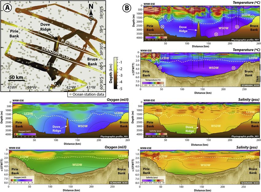
F.J. Lobo et al. Marine Geology 441 (2021) 106598
1. Introduction due to the gradual opening of the different basins (e.g., Pérez et al.,
2017, 2021). Additionally, Mass Transport Deposits (MTDs) are known
The interaction of down- and along-slope processes in deep-water to be a main constituent of the long-term sedimentary record of the
settings is a relatively common phenomenon, yet because the resulting Scotia Sea basins (Pérez et al., 2016; Somoza et al., 2019), given their
deposits may exhibit similar sedimentological and morphological fea proximity to the Scotia Plate active tectonic boundaries and associated
tures, distinguishing between them may not be straightforward. Both seismicity (Fig. 1).
processes are well reflected by seismic data, so that the resulting de Most of the previous studies in the Scotia Sea basins are based on the
posits may be categorized as mixed (downslope/alongslope) drift sys interpretation of low-resolution multichannel seismic data; therefore,
tems (Rebesco, 2005; Faugeres and Stow, 2008). The most common deep-water sedimentary patterns are only known on generic terms and
pattern is exemplified by downslope-generated deposits that tend to be at long-term late Cenozoic timescales involving millions of years, both in
pirated by contour currents, generating a large variety of mixed or relation with the development of contouritic and mass transport depo
hybrid deposits that interfinger, imbricate or are laterally associated sition. In contrast, the study of recent and/or present-day deep-water
(Faugères et al., 1999; Faugères and Mulder, 2011; Sansom, 2018; sedimentary patterns has only been conducted in few places, where
Fonnesu et al., 2020). The most effective interplay of sediment drifts contourite deposits have been interpreted as the dominant depositional
often occurs in turbidity-current supplied systems (i.e., channel-levee patterns (e.g., Maldonado et al., 2003; García et al., 2016), although
systems and deep-water fans) that are reworked by relatively low ve local interactions with MTDs have also been reported (Owen et al.,
locity contour currents (Stow and Faugères, 2008). Drift development 2014). In order to overcome this gap of knowledge involving recent
may, however, also be conditioned by debrites (e.g., Knutz and Cart processes and products, Dove Basin shows good potential for the study of
wright, 2004), as well as by hemipelagites or glacigenic deposits late Quaternary interactions between contourite and gravitational pro
(Rebesco, 2005). cesses along the southern boundary of the Scotia Plate (Fig. 1). From an
In different areas around the Antarctic continent supplied by glacial oceanographic standpoint, Dove Basin is located north of Orkney Pas
and glacio-marine processes, turbiditic systems with channel-levee sage, which constitutes the main gateway through which deep Antarctic
complexes fed from shelf sediment input are subsequently reshaped by waters flow with the highest velocities into the Scotia Sea (Locarnini
vigorous contour currents, constructing asymmetric levees and/or et al., 1993; Naveira Garabato et al., 2002b; Tarakanov, 2010). In
lateral mounded drifts (e.g., Escutia et al., 2002; Michels et al., 2002; addition, its physiography is very irregular, as the margins are formed by
Rebesco et al., 2002; Kuvaas et al., 2005; Uenzelmann-Neben, 2006; numerous faults; an extinct spreading center occurs in the middle part of
Solli et al., 2008). the basin and is bounded to the south by the active Scotia-Antarctica
In contrast, depositional settings in the Scotia Sea basins are very far plate boundary. MTD development is particularly favored in this
from the sediment input derived from glacial and glacio-marine pro setting (Ruano et al., 2014; Pérez et al., 2016), for which reason, a strong
cesses, meaning the formation of extensive turbidite sediment bodies is interaction between alongslope processes and MTDs could be expected
less significant (e.g., Martos et al., 2013) (Fig. 1). The sedimentary infill here.
of the different Scotia Sea basins is mainly composed of contourite This study is an extension of the work conducted by Pérez et al.
sediment bodies that prevailed after the basins were formed by the late (2017) that focused on the long-term tectonic and stratigraphic devel
Miocene (Maldonado et al., 2006). The influence of bottom currents on opment of Dove Basin. Our present contribution deals with recent (i.e.,
deep-water sedimentation patterns increased progressively over time late Quaternary) sedimentary processes through the analysis of
Fig. 1. Geological setting of the Scotia Plate between the South American and Antarctic plates (each plate is highlighted with a different colour), with historical
seismicity along the South Scotia Ridge classified according to magnitude. The geographical location of Dove Basin between Pirie and Bruce banks is indicated by a
white rectangle. Background bathymetric data extracted from the ETOPO1 1 Arc-Minute Global Relief Model (NOAA National Geophysical Data Center, 2009).
Seismicity database extracted from the National Earthquake Information Center (USGS, 2021).
2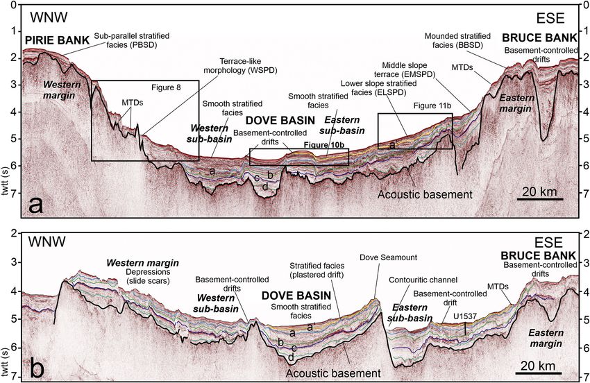
F.J. Lobo et al. Marine Geology 441 (2021) 106598
multibeam bathymetric data and high-resolution sub-bottom profiles. (Eagles et al., 2006; Barker et al., 2013; Eagles and Jokat, 2014) or
We aim to study: (1) the relevance of Dove Basin as an oceanographic during the late Oligocene-early Miocene (Galindo-Zaldívar et al., 2014;
conduit for the entrance of Antarctic deep waters from the Weddell Sea Schreider et al., 2018).
into the Scotia Sea as recorded in recent sedimentation patterns; (2) the
major types of contourite deposition and the differences with nearby
basins; and (3) the role of the basin as an MTD container and the 2.2. Oceanographic setting
interaction of MTDs with bottom-current processes in the different do
mains of the basin. The Antarctic Circumpolar Current (ACC) flows eastward around the
Antarctic continent, contributing to its thermal isolation (Rintoul et al.,
2. Study area 2001). The ACC comprises several fronts that extend from north to south
across the Scotia Sea (Orsi et al., 1995). Of those fronts, the Southern
2.1. Geological setting ACC Front (SACCF) and the Southern Boundary of the ACC (SB) extend
north of Dove Basin (Fig. 2a). The Circumpolar Deep Water (CDW)
The Scotia Plate is located between the South American and Ant propagates freely from west to east in the field of the ACC (Naveira
arctic plates, bounded by a complex arrangement of tectonic structures Garabato et al., 2002a; Tarakanov, 2010). The deepest layer of CDW
forming the Scotia Arc (Fig. 1). The eastward migration of the arc during with potential temperatures of 0.2–0.9◦ is known as the Lower
the Eocene and Oligocene led to the fragmentation of the continental Circumpolar Deep Water (LCDW). The dominant eastward propagation
bridge linking the two continents, hence to their eventual separation (e. of LCDW exhibits three major pathways; the southernmost path south of
g., Lodolo et al., 2006; Eagles and Jokat, 2014; Maldonado et al., 2014). the SB crosses Dove Basin from west to east and splits in the middle part
Subsequently, the continental fragments were dispersed along the of the basin (Tarakanov, 2010) (Fig. 2a).
boundaries of the Scotia Plate (Barker, 2001; Dalziel et al., 2013). The deep-water circulation in the Scotia Sea below CDW is domi
Among them, the South Scotia Ridge (SSR) lies along the southern nated by the northward overflow of Weddell Sea Deep Water (WSDW)
boundary of the Scotia Plate (Fig. 1). The SSR is formed by complex (Morozov et al., 2010). The WSDW, with potential temperatures below
alternations of structural highs and lows developed under a dominant 0.2◦ , is formed in the Weddell Gyre, which circulates clockwise in the
strike-slip tectonic regime. The SSR exhibits a significant seismic activ Weddell Sea (Locarnini et al., 1993) above the Weddell Sea Bottom
ity, and most of the earthquake epicenters are shallow (0–70 km) (e.g., Water (WSBW). The WSDW crosses the SSR through four different
Galindo-Zaldívar et al., 2002; Bohoyo et al., 2007; Lodolo et al., 2010; gateways (Philip, Orkney, Bruce and Discovery passages, from west to
Civile et al., 2012). North of the SSR, several continental blocks of the east) (Naveira Garabato et al., 2002b). Orkney Passage, to the east of the
ancient bridge separate a number of small basins (Ona, Protector, Dove South Orkney Microcontinent, is the deepest gateway, where the coldest
and Scan, from west to east) (Fig. 1). and most intense WSDW flows northward as a narrow, bottom intensi
Dove Basin is an NNE-SSW elongated oceanic basin of sigmoidal fied current with velocities of around 50 cm/s (Locarnini et al., 1993;
shape extending 200 km N-S and 150 km E-W, bounded laterally by the Naveira Garabato et al., 2002b) (Fig. 2b). Two distinct varieties of
Pirie (W) and Bruce (E) continental banks (Fig. 1). It contains an elon WSDW flow over the SSR —an older, warmer and more saline WSDW
gated high along its middle part, formed by the Dove Ridge and its located deeper in the water column, and a colder, fresher and more
continuations northward (Dove Seamount) and southward (Galindo- recently ventilated WSDW (Naveira Garabato et al., 2002a). These
Zaldívar et al., 2014). The central ridge represents the extinct spreading distinct fractions have been referred to as the lower and upper WSDW,
axis, which is bounded by transtensional strike-slip faults, while the the boundary between the two varieties being located at 2000–2500 m
marginal banks are bounded by normal faults that individualize struc water depth along Dove Basin (Tarakanov, 2009). The WSDW branch
tural blocks (Pérez et al., 2017). Different age models have been pro flowing through Orkney Passage circulates along Dove Basin in an an
posed for the spreading of the basin, either during the late Eocene ticyclonic gyre (Naveira Garabato et al., 2002a; Tarakanov, 2009)
(Fig. 2b).
Fig. 2. Distribution of main deep-water masses in Dove Basin. (a) Scheme of circulation of the Lower Circumpolar Deep Water (LCDW) and location of the fronts of
the Antarctic Circumpolar Current (ACC) in Dove Basin (after Tarakanov, 2010). Nomenclature of ACC fronts: SACCF: Southern ACC Front; SB: Southern Boundary of
the ACC. (b) Scheme of circulation of the Weddell Sea Deep Water (WSDW) in Dove Basin (after Tarakanov, 2009). Legend: LWSDW: lower WSDW; UWSDW: upper
WSDW. Background bathymetric data extracted from the 15 arc-second GEBCO 2020 bathymetric grid (GEBCO Compilation Group, 2020).
3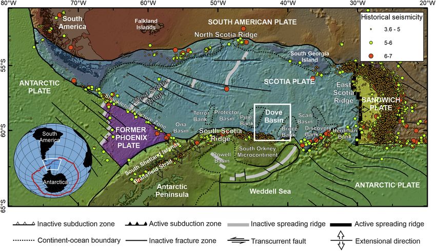
F.J. Lobo et al. Marine Geology 441 (2021) 106598
Hydrographic sections reveal that the shallow parts of the morpho A progressive change from downslope- to alongslope-influenced
logical highs surrounding Dove Basin are under the influence of the sedimentation has been documented in the long-term sedimentary re
southernmost path of LCDW (Fig. 3), as suggested by Tarakanov (2010). cord of Dove Basin (Pérez et al., 2017). MTDs also underwent a sub
Below, most of Dove Basin is occupied by the lower WSDW (LWSDW), stantial increase in abundance (Ruano et al., 2014; Pérez et al., 2016).
whereas the boundary with the upper WSDW (UWSDW) deepens to the However, the interaction between alongslope and downslope processes
north (Tarakanov, 2009). during the late Quaternary has not been studied in Dove Basin.
3. Methodology
2.3. Deep-water sedimentation patterns
3.1. Database
The Cenozoic sedimentary record of the Scotia Sea basins is char
acterized by several seismic units, pertaining to two distinct intervals
The data used in this study comprises a set of high-resolution marine
(Maldonado et al., 2006). The older units developed during the process
geophysical and hydrographic data (Fig. 4). Geophysical data include
of rifting and seafloor spreading, and they show frequent mass transport
multibeam bathymetric data and topographic parametric sub-bottom
and turbidite deposits. The younger units overlie a high-amplitude,
(TOPAS) profiles, with ancillary multi-channel seismic data.
regionally continuous reflection assigned a late Miocene age (Pérez
Multibeam bathymetric data were obtained during the SCAN 2001,
et al., 2021). These younger units contain abundant evidences of sedi
SCAN 2004 and SCAN 2008 geophysical surveys onboard RV Hespér
ment drift development under the combined influence of the ACC and
ides. The SIMRAD EM 12S and EM 120 echo sounders were set up at an
the WSDW (Maldonado et al., 2003; Pérez et al., 2017). Intercalations of
operating frequency of 12 kHz and swath apertures of 90 to 120◦ ,
contourite deposits with MTDs are also abundant in these younger units
providing vertical resolutions of 0.1–0.4 m. Multibeam data used for this
north of the SSR, and MTD origins have been related to tectonic and
study provide about 43% of coverage in Dove Basin. Multibeam files
earthquake activity in the nearby plate boundary (Ruano et al., 2014;
were post-processed with NEPTUNE™ software. Postprocessing of
Pérez et al., 2016). The most recent seismic unit occurs above reflector
bathymetric data included manual data cleaning to remove erroneous
a’, recently dated as late Quaternary in age (i.e., ≈0.4 Ma) (Pérez et al.,
soundings and outlier points. Grids were created with GMT (Generic
2021).
Fig. 3. Hydrographic characterization of key oceanographic transects for Dove Basin. (a) Geostrophic velocities of a segment of the ANDREX/I6S hydrographic
section along the South Scotia Ridge (location indicated in c), with positive (negative) values indicating southward (northward) flows (modified from Jullion et al.,
2014). The highest northward velocity values occur across Orkney Passage, located south of Dove Basin; (b) hydrographic structure of the water column as defined by
the potential temperature along a segment of the AJAX hydrographic section (location indicated in c), which obliquely crosses Dove Basin (simplified from Tar
akanov, 2009). Solid bold lines indicate the boundaries between water masses. The boundary between Circumpolar Deep Water (CDW) and Weddell Sea Deep Water
(WSDW) is highlighted in red colour. (c) Geographical location of sections a and b. (For interpretation of the references to colour in this figure legend, the reader is
referred to the web version of this article.)
4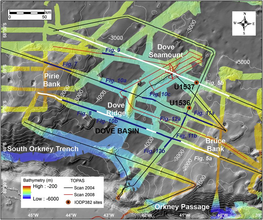
F.J. Lobo et al. Marine Geology 441 (2021) 106598
Fig. 4. Geographical location of data used in
this study with reference to Dove Basin,
including multibeam bathymetric coverage
and sub-bottom topographic parametric
(TOPAS) profile transects. Major geomor
phological features are indicated. The loca
tions of two multi-channel seismic sections
crossing the basin are highlighted in white,
whereas the locations of sub-bottom profile
examples are highlighted in blue colour. The
location of drilling sites U1536 and U1537
collected during IODP Expedition 382 is also
marked. Background bathymetric data
extracted from the 15 arc-second GEBCO
2020 bathymetric grid (GEBCO Compilation
Group, 2020). (For interpretation of the ref
erences to colour in this figure legend, the
reader is referred to the web version of this
article.)
Mapping Tools) software; xyz clean data were gridded with block and projecting water sample stations onto the seismic cross sections at
median and surface GMT commands. Bathymetric grids with a 50 m cell distances of up to 50 km. The fields were smoothed to better represent
resolution were interpreted using ArcGIS™ software (Fig. 4). To fill the time-averaged distributions to reduce noise related to variations in
gaps of the multibeam data coverage, we used a 15 arc-second bathy water mass distributions. This approach provided a regional dataset
metric grid (GEBCO Compilation Group, 2020). large enough to suppress small-localized features and seasonal events.
Nearly 3000 km of acoustic sub-bottom profiles collected in the The projection distance provided sufficient resolution for clearly iden
SCAN 2004 and SCAN 2008 surveys with a TOpographic PArametric tifying regional changes in the hydrographic profiles. Two hydrographic
Sonar PS 18 (TOPAS™) system were used in this study (Fig. 4). Sub- panels crossing Dove Basin with a WNW-ESE trend were constructed. A
bottom data were acquired operating in Chirp mode sweeping be multibeam bathymetric section (Profile_H01) crossing Dove Ridge was
tween two different frequencies: 1.5 and 5 kHz. Pulse length was 20 ms merged with hydrographic data to highlight the water column structure
and shooting interval was 5000 ms. Recorded signal length was of 300 in the middle part of the basin. The southern panel is located south of
ms with a sampling frequency of 35,087 Hz. The Chirp signal was Dove Ridge, where the multichannel seismic profile SC03 was combined
deconvoluted and filtered with a 1 kHz high-pass filter; also, different with hydrographic data (temperature, salinity and dissolved oxygen).
time-variable gain ramps were applied during acquisition. Post pro
cessing included spike removal and noise attenuation using Radexpro™ 3.2. Morpho-stratigraphic interpretation
software. For time-to-depth conversions in sub-bottom profiles, a stan
dard velocity of 1500 m/s was used. Signal penetration is variable in the Recent studies in Dove Basin have provided age constraints for the
study area —though values of tens of meters are common, they may post-late Miocene sedimentary record of Dove Basin based on the cor
locally reach over 100 m. Those thickness values are in agreement with a relation between drilling sites U1536 and U1537 collected during IODP
late Quaternary age (i.e., deposits above reflector a’) (Pérez et al., 2021). Expedition 382 (Fig. 4) and low-resolution multichannel seismic profiles
Sub-bottom profiles were imported to IHS Kingdom™ software for (Pérez et al., 2021). As a result, four main basin-wide seismic horizons
visualization and interpretation purposes. have been defined (Fig. 5). Reflector-a’ is the uppermost seismic horizon
Two multichannel seismic lines collected in the SCAN 2004 survey and has an estimated late Quaternary (i.e., ≈ 0.4 Ma) age (Pérez et al.,
crossing the basin were used to correlate the uppermost seismic horizon 2021). We used available multichannel seismic data and extended the
with sub-bottom acoustic profiles and to highlight the underlying con interpretation of reflector-a’ to our high-resolution sub-bottom profile
trol of deep geological structures on the morphology of recent sedi dataset as much as possible. Due to limitations in data coverage,
mentary features (Fig. 5). Seismic profile acquisition and processing reflector-a’ could be followed over most of the eastern part of the basin;
details are provided in previous studies (Galindo-Zaldívar et al., 2014; the recognition of reflector-a’ west of Dove Ridge was much more
Pérez et al., 2017). uncertain.
Hydrographic data extracted from the World Ocean Atlas 2018 The main sub-surface morpho-sedimentary features of Dove Basin
(Boyer et al., 2018) using Ocean Data View™ software (Ocean Data (mostly defined above reflector-a’) were mapped, taking into account
View, 2020) were used to create joint hydrographic and seismic cross the morphological character observed in bathymetric data and the
sections. Due to the lack of synoptic hydrographic sections, we con acoustic facies imaged in the sub-bottom profiles (Fig. 6). To interpret
structed cross-basin sections by combining all available CTD stations contourite features, major subdivisions of contourite depositional and
5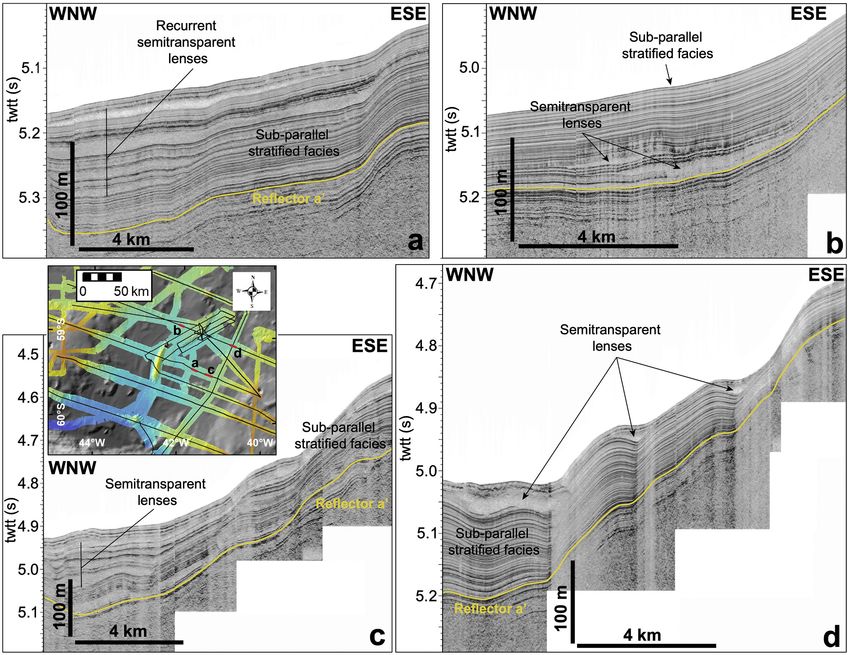
F.J. Lobo et al. Marine Geology 441 (2021) 106598
Fig. 5. Examples of multichannel seismic profiles crossing Dove Basin and exhibiting the influence of deep structures on the surface geomorphology: (a) seismic
section in the middle part of the basin south of Dove Ridge, where recent deposition is dominated by extensive drifts on the basin slopes, whereas in the central plain
sheeted drifts and drifts deformed above basement highs are common. The location of sub-bottom profiles in Figs. 8, 10b and 11 is shown; (b) seismic section in the
northern part of the basin crossing Dove Seamount, characterized by the widespread occurrence of basement-controlled drifts and mass movements on the basin
slopes. Major seismic horizons (reflectors d, c, b, a and a’) defined in the Cenozoic sedimentary record of the basin are depicted (Pérez et al., 2017). Age intervals (in
Ma) of seismic horizons (Pérez et al., 2021): Reflector-d age is unresolved; Reflector-c: >8.4; Reflector-b: 3.3–4.8; Reflector-a: 1.2–1.8; Reflector-a’: 0.4–07. Location
of site U1537 is indicated in the eastern sub-basin (Fig. 5b). Legend: PBSD: Pirie Bank Sheeted Drfit; WSPD: Western Slope Plastered Drift; ELSPD: Eastern Lower
Slope Plastered Drift; EMSPD: Eastern Middle Slope Plastered Drift; BBSD: Bruce Bank Sheeted Drift; MTDs: Mass-Transport Deposits. The location of multichannel
seismic profiles is indicated in Fig. 4.
erosional features were determined (Faugères et al., 1999; Faugères and 4. Recent morpho-stratigraphy of Dove Basin
Mulder, 2011; Rebesco et al., 2014). In this study, we use the term
basement-controlled drift as a generalization of the fault-controlled drift 4.1. Sub-bottom acoustic facies and seafloor morphological patterns
type, which is included in recent contourite classifications (e.g., Rebesco
et al., 2008; Rebesco et al., 2014). Specifically, basement-controlled The observations are separated taking into account the large-scale
drifts are regarded as sediment drifts whose morphology is determined physiography of the basin, and three major domains are considered:
to some extent by underlying basement structures (Fig. 5). The inter Pirie Bank/western margin, central basin, and Bruce Bank/eastern
pretation of mass movements was based on previous descriptions of margin. In the central basin, a central ridge separates two sub-basins.
related geomorphological features and deposits in high-latitude settings,
such as MTDs and gravity-driven erosional features (e.g., Forwick and 4.1.1. Pirie Bank and the western margin
Vorren, 2007; Masson et al., 2010; Baeten et al., 2013; Laberg et al., The top of Pirie Bank is characterized by a relatively smooth
2014). morphology with sub-parallel stratified facies, having maximum thick
The observed morpho-sedimentary features were mapped at a ness values observable in sub-bottom profiles of around 75 m (Figs. 5a,
regional scale (Fig. 6), considering widely spaced acoustic sub-bottom 7). Several elongated depressions occur around the top of the bank,
profiles and multichannel seismic data (Fig. 4). Bathymetric finger particularly in the northern part (Fig. 6). The depressions exhibit a
prints of recent morpho-sedimentary features were also included, based dominant NE-SW trend, although their paths are slightly sinuous. The
on bathymetric data of variable resolution. The maps are therefore longest depressions are over 15 km long. They show V-shaped cross-
limited by the density and nature of the data, resulting in three types of sections, with maximum thalweg depths less than 50 m (Fig. 7).
spatial representation: (1) large-scale physiographic features and major Irregular depressions with semi-circular, amphitheater-shaped plan-
sedimentary features were laterally correlated; (2) sedimentary features view morphologies cover large extents of the slope (Figs. 5b, 6). The
of limited distribution with outstanding bathymetric expression were heads of the depressions are several kilometers wide. Downslope,
mapped along the multibeam bathymetric coverage stripes; (3) sedi different generations of arcuate depressions are observed elsewhere. In
mentary features without a bathymetric footprint were mapped along cross-sections, depressions exhibit abrupt slopes with no acoustic signal
the acoustic sub-bottom profiles. Water depths are indicated as meters penetration and/or semitransparent acoustic facies (Fig. 8).
below sea level. Bathymetric highs extend laterally over tens of kilometers on the
slope of Pirie Bank (Fig. 6). Most of these highs are highly reflective and
exhibit mounded external morphologies (Fig. 8), and occur in front of
6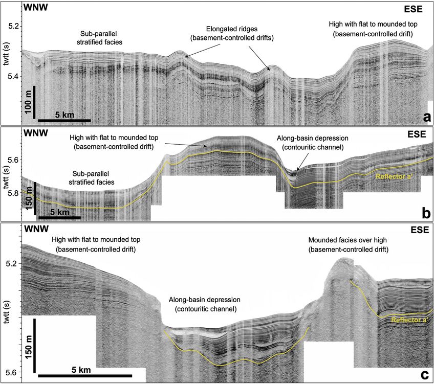
F.J. Lobo et al. Marine Geology 441 (2021) 106598
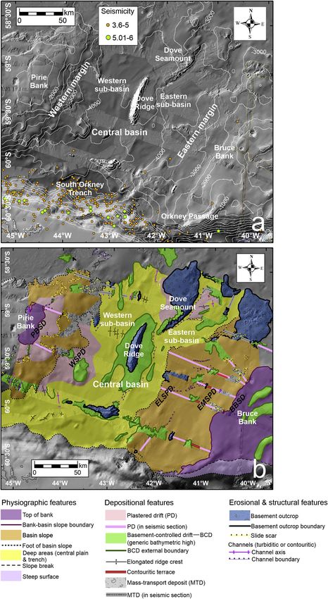
Fig. 6. Geomorphological interpretation of Dove
Basin. (a) Uninterpreted geomorphological map of the
study area, with hill-shaded multibeam bathymetric
data illuminated from the northwest superimposed on
the 15 arc-second bathymetric grid (GEBCO Compi
lation Group, 2020). Epicenters of historical seis
micity are superimposed. Seismicity database
extracted from the National Earthquake Information
Center (USGS, 2021). (b) Interpretation of major
geomorphological features in Dove Basin. Legend:
PBSD: Pirie Bank Sheeted Drift; WSPD: Western Slope
Plastered Drift; ELSPD: Eastern Lower Slope Plastered
Drift; EMSPD: Eastern Middle Slope Plastered Drift;
BBSD: Bruce Bank Sheeted Drift.
7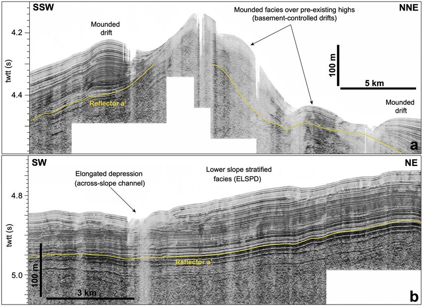
F.J. Lobo et al. Marine Geology 441 (2021) 106598
Fig. 7. Acoustic sub-bottom profile crossing the top and uppermost slope of Pirie Bank. Stratified facies and V-shaped depressions are interpreted as contourite
features such as the Pirie Bank Sheeted Drift (PBSD) and contouritic channels above it, because of their distribution around and over an isolated basement high and
the predominant trend along the isobaths. See location in Fig. 4.
the sets of arcuate depressions (Fig. 6). having maximum depths of 20 m and maximum widths of 2 km (Fig. 9).
Most of the lower slope exhibits a smoother morphological pattern, Several bathymetric elevations tens of meters high are observed in the
extending downslope and alongslope for tens of kilometers (Fig. 6). The lower slope (Fig. 6). These highs constitute antiform-like structures
low-lying deposits are constituted by sub-parallel stratified acoustic composed of stratified reflections (Fig. 8).
facies with intercalated semitransparent sheets/lenses. A terrace-like
morphology with a measured slope of 0.5◦ is locally identified at 4.1.2. The central basin
about 3650 m water depth (Figs. 5a, 8). The thickness of these deposits Three sub-domains are defined in the central basin: the western and
ranges between 35 and 45 m. Locally, semitransparent lenses stack eastern sub-basins and the central ridge which separates the sub-basins
vertically, amounting to maximum thickness of around 75 m (Fig. 9). At (Fig. 5).
the seafloor, these semitransparent facies produce several irregularly
shaped lobes 10–15 km wide with channel-like features on top of them, 4.1.2.1. The western sub-basin. This part of the basin is constrained
Fig. 8. Acoustic sub-bottom profile crossing the lower slope of the western margin of Dove Basin. To the left, abrupt slopes of slide scars evolve downslope to
irregular facies with some hyperbolas, interpreted as the result of mass transport deposits (MTDs). To the right, stratified facies with some intercalated semi
transparent lenses are interpreted as the Western Slope Plastered Drift (WSPD), locally interrupted by a basement-controlled drift. See location in Fig. 4.
8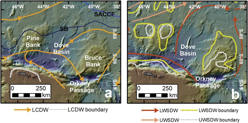
F.J. Lobo et al. Marine Geology 441 (2021) 106598
Fig. 9. Acoustic sub-bottom profile at the base of the slope in the western margin of Dove Basin. Semitransparent lenses interpreted as debris flow deposits, a
particular type of mass-transport deposit (MTD), are intercalated with stratified facies. These facies are crossed by gravitational channels. See location in Fig. 4.
between the western slope and the central ridge. The western sub-basin sedimentary accumulation attached to the Dove Ridge (Fig. 5b). It is
exhibits a very smooth, low-lying relief; in the sub-surface, sub-parallel mostly U-shaped, but locally it exhibits steeper walls with signs of
stratified acoustic facies with the local occurrence of semitransparent erosion. The channel is partially infilled with sub-parallel stratified
lenses occur (Figs. 5a, 10a, b). Maximum sediment thickness above facies, including some intercalations of semitransparent lenses (Fig. 10b,
reflector-a’ is of around 90 m. Several morphologies of kilometric scale c). It is 1.5–2.5 km wide in the southern part and increases to higher
are identified; they feature sets of elongated ridges, irregular bathy widths (around 4 km) in the northern part. Maximum incision depth of
metric highs, and few elongated depressions (Fig. 6). the channel is below 40 m. The major channel appears to split into two
Sets of elongated ridges 3–5 km wide and up to 40 m high occur in branches at the southwestern tip of Dove Seamount. The western branch
different parts of the western sub-basin. To the north, these ridges does not show northward continuity, but the eastern branch is very well
exhibit N-S to NNE-SSW trends, whereas in the southern part of the basin marked and continuous along the entire length of the Dove Seamount’s
the ridges trend NE-SW (Fig. 6). They exhibit mounded external shapes base, with a mainly NE-SW orientation (Fig. 6). Towards the northeast,
and are 20–30 m high, with convex-up stratified acoustic facies adapting this channel exhibits another bifurcation.
to underlying highs (Fig. 10a).
Bathymetric highs are larger than the elongated ridges, attaining 4.1.2.3. The eastern sub-basin. The eastern sub-basin has smooth sea
maximum widths greater than 10 km and maximum heights of about floor relief and internal stratified reflections with intercalations of
100 m. Overall, their orientations range from N-S to NNE-SSW, and they semitransparent lenses (Figs. 5a, 10a). Locally, semitransparent facies
show sub-parallel stratified facies overlying older bathymetric highs occur at the seafloor in the proximity of basement highs. In this sub-
(Figs. 5b, 10a). basin, the maximum thickness of surficial deposits above reflector-a’ is
Several types of elongated depressions are identified. A channel higher (> 150 m) than in the western sub-basin. This general trend is
almost 3 km wide occurs at the base of the slope, splitting into two interrupted by several N-S elongated seafloor highs (Fig. 6). Indeed, the
branches around a basement outcrop (Fig. 6). Other elongated de northern outlet of the sub-basin is largely blocked by several highs with
pressions occur adjacent to morphological highs, showing similar trends acoustic responses indicative of a lack of acoustic signal penetration
and erosive character, and with shallow depths (7.5–15 m) in the partially or totally covered by stratified mounded deposits.
channel thalwegs in comparison to the surrounding seafloor.
4.1.3. Bruce Bank and the eastern margin
4.1.2.2. The central ridge. The central ridge includes the aligned At the top of Bruce Bank, several elongated highs with broad
bathymetric reliefs of Dove Seamount, Dove Ridge and the WNW-ESE mounded and stratified patterns can be distinguished between 1250 and
basement elevation south of Dove Ridge (Figs. 5, 6). These highs are 1700 m water depths (Figs. 5, 6). The uppermost slope exhibits an
surrounded by low-lying sedimentary elevations with flat to mounded irregular morphology with steep surfaces passing laterally into moun
tops (i.e., mesa-like morphology) (Fig. 10b). Over most of the area ded, semitransparent highs (Figs. 5, 11a) and relatively thin strata
surrounding Dove Ridge, the low-lying deposits exhibit sub-parallel (average thickness less than 75 m). The middle slope is marked by a sub-
stratified acoustic facies thinning towards their margins, where semi horizontal terrace-like morphology with an average slope of 0.45◦
transparent facies are intercalated in the stratified facies (Fig. 10b). shallowing northward from 3100 to 2400 m. Downslope, the middle
Other sedimentary accumulations with interbedded stratified and slope terrace is bounded by a more steeply deepening area with local
semitransparent acoustic facies are attached to the western side of Dove semitransparent acoustic character, evolving in the lower slope to gently
Seamount, where they occupy an irregular indentation of the seamount dipping (as low as 1◦ ) sub-surface strata around 150 m thick, with in
and extend to the north (Fig. 5b). tercalations of semitransparent lenses (Figs. 5a, 11). Maximum sediment
Several seafloor elongated depressions occur along the eastern side thickness above reflector-a’ is of about 140 m.
of the central elevations (Fig. 6). A curved channel surrounds a sedi The eastern slope also exhibits diverse seafloor features of kilometric
mentary mound in the northern part of the southernmost basement scale, i.e., arcuate to irregular depressions and semitransparent deposits,
ridge. A discontinuous channel runs along the eastern side of the irregular seafloor highs, and elongated depressions (Figs. 5, 6). Arcuate
9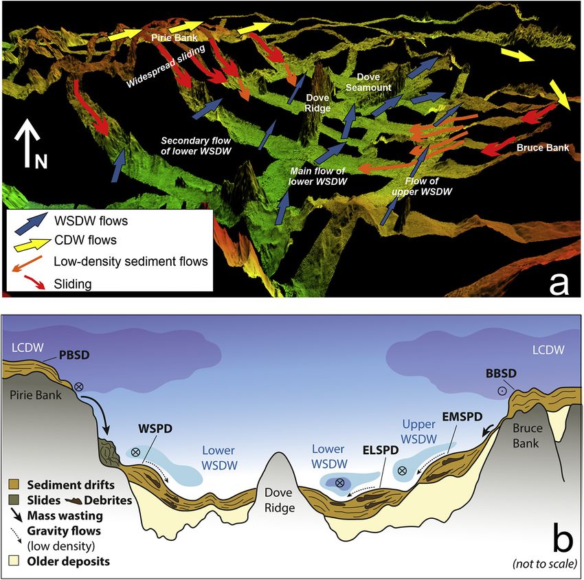
F.J. Lobo et al. Marine Geology 441 (2021) 106598
Fig. 10. Acoustic sub-bottom profiles crossing different morpho-stratigraphic elements in the central part of Dove Basin: (a) Section crossing the western sub-basin
showing a dominance of stratified facies with constant thickness comprising different types of sediment drifts; (b) Section crossing the central barrier south of Dove
Ridge, dominated by a major basement-controlled drift that laterally evolves into stratified facies typical of the central basin; (c) Section crossing the eastern sub-
basin mainly depicting the main contouritic channel constrained by basement-controlled drifts. Reflector-a’ is interpreted in sections b and c. See location in Fig. 4.
to irregular depressions opening downslope are abundant on the upper 4.2. Changes in acoustic character above and below reflector-a’
slope in the northern part of Bruce Bank, at water depths greater than
1600 m (Fig. 6). Reflector-a’ is marked in sub-bottom data by a high amplitude
Irregular seafloor highs occur on the lower slope (Fig. 5b). The reflection traced through most of the eastern part of the basin. However,
largest ones (over 10 km wide) exhibit very intricate boundaries in plan its lateral continuity is frequently interrupted by irregular highs. In
view and a preferential W-E trend, with their tops at water depths as addition, reflector-a’ could not be followed towards the upper part of the
shallow as 2500 m (Fig. 6). Some of the highs exhibit mounded re slopes, due to the occurrence of highly reflective, erosional features.
flections at the top, while others do not exhibit acoustic signal pene Acoustic facies tend to be more uniform and with lower lateral conti
tration (Fig. 12a). nuity below reflector-a’. Above, acoustic facies consist of a well-defined
Different types of elongated depressions are found on the eastern sub-parallel stratified pattern, with alternations of high and low
margin (Fig. 6). The depressions over Bruce Bank and in the upper slope amplitude reflections with high lateral continuity (Fig. 13). In the cen
are 1–2 km wide and up to 70 m deep, exhibit alongslope trends and V- tral basin plain, the subparallel stratified pattern observed in the over
shapes, with truncated reflections at the flanks. In the lower slope, more lying deposits is interrupted by semitransparent lenses that occur at
frequent elongate depressions trend oblique to perpendicular to the different stratigraphic levels (Fig. 13a, b). In the eastern slope of the
slope. They are relatively narrow (1–2 km) and extend tens of kilome basin, the sub-surface acoustic record above reflector-a’ exhibits a
ters. In cross-section, they are V-shaped and have variable depths of a higher abundance of semitransparent lenses, that locally stack vertically
few tens of meters. They are mostly characterized by semitransparent (Fig. 13c), although stratified facies are dominant laterally (Fig. 13d).
acoustic responses (Figs. 11b, 12b).
5. Hydrological structure of the water column
Hydrographic profiles across Dove Basin show that the upper part of
10F.J. Lobo et al. Marine Geology 441 (2021) 106598
Fig. 11. Acoustic sub-bottom profiles crossing the slope of the eastern margin of Dove Basin: (a) Downslope alternation of mass transport deposits (MTDs) and
plastered drifts in the northern part of the eastern slope, such as the Eastern Middle Slope Plastered Drift (EMSPD) and the Eastern Lower Slope Plastered Drift
(ELSPD); (b) Stratified facies of the Eastern Lower Slope Plastered Drift (ELSPD) with intercalated semitransparent facies regarded as MTDs. Reflector-a’ is partially
interpreted in sections a and b. See location in Fig. 4.
the water column is characterized by a sheeted water mass with tem current erosion, and can be regarded as constituting contouritic chan
peratures higher than 0.5 ◦ C that influences the upper parts of Pirie and nels, as in other margins (Howe et al., 1997; Cunningham et al., 2002).
Bruce banks at water depths less than 1500–2000 m (Fig. 14). This In the western margin, stratified deposits with top horizontal sur
uppermost part is attributed to the Lower Circumpolar Deeep Water faces at the base of the slope are interpreted as a plastered drift —named
(LCDW). the Western Slope Plastered Drift (WSPD)— that exhibits intercalated
Below the LCDW, the basin plain is occupied by WSDW (Fig. 14). gravity-flow deposits. The bulk of the eastern margin is dominated by
Within the confines of Dove Basin, at least two main ventilated cores of sub-parallel stratified facies at two different water depth levels, forming
WSDW with low temperature and high salinity are identified in the two distinct plastered drifts: the Eastern Middle Slope Plastered Drift
eastern sector, adjacent to the slope of Bruce Bank, at water depths of (EMSPD), and the Eastern Lower Slope Plastered Drift (ELSPD) (Figs. 6,
3500–4000 m (the lower core) and 2500–3000 m (the upper core). In the 11). These plastered drifts would be similar to other sediment drifts
western part of the basin, a smaller WSDW core is identified along the reported in the Scotia Sea and the western Falkland Trough (Howe et al.,
slope of Pirie Bank, at maximum water depths of 3500 m (Fig. 14). 1997; Owen et al., 2014).
In the western margin, the downslope arrangement of morpho-
6. Interpretation of morpho-sedimentary features sedimentary features —ranging from upper amphi-theater-shaped de
pressions to lower semitransparent deposits— likely portrays a gravi
The sub-bottom acoustic facies of Dove Basin are primarily charac tational system with recurrent episodes of sediment failures (e.g.,
terized by semitransparent facies interbedded with sub-parallel strati Damuth and Olson, 2001). Similar features area also recognized along
fied facies. In other deep-water settings around the Antarctic dominated the upper slope of the eastern margin, although with lower spatial
by sediment drifts, such facies successions have been interpreted as the development (Fig. 11a). Arcuate depressions generating steep slopes
alternating imprint of alongslope bottom-water flows and downslope evolving downslope to mounded patterns are interpreted as mass
gravitational flows (Rebesco et al., 2002). A similar overall interpreta transport or slide scars, associated with secondary escarpments and
tion is invoked here for the late Quaternary sedimentary record of Dove MTDs, resembling the pattern observed elsewhere in the Scotia Sea
Basin. (Owen et al., 2014; García et al., 2016) and in high-latitude settings (e.
g., Forwick and Vorren, 2007; Baeten et al., 2013; Laberg et al., 2014).
These facies evolve downslope into acoustically transparent and/or
6.1. Banks and basin margins
semitransparent acoustic facies interpreted as debris flow deposits
(Damuth and Olson, 2001; Owen et al., 2014; Larter et al., 2016); yet
Sub-parallel stratified facies covering part of the top of Pirie and
here they are regarded as more generic MTDs, which may be interca
Bruce banks, and extending downslope to the upper slopes, are inter
lated between the slope plastered drifts or stack vertically forming
preted as sheeted drifts (Pirie Bank Sheeted Drift–PBSD and Bruce Bank
debris fans (Fig. 9).
Sheeted Drift–BBSD) (Fig. 7). Sheeted drifts are a common feature in
Channels in the lower slope of the eastern margin (Fig. 12b) or on top
diverse settings of the Scotia Sea (e.g., García et al., 2016; López-Quirós
of semitransparent fans in the western margin are similar to cross-
et al., 2020). These sheeted drifts are locally affected by elongated de
cutting incisions recognized in areas of debris flow deposit occurrence
pressions with a main alongslope trend interpreted as the result of
11F.J. Lobo et al. Marine Geology 441 (2021) 106598
Fig. 12. Acoustic sub-bottom profiles highlighting specific morpho-stratigraphic features in the eastern margin of Dove Basin: (a) Basement-controlled drifts and
lateral mounded drifts; (b) Example of across-slope channel with underlying semitransparent facies above a generally stratified slope section, interpreted as a portion
of the Eastern Lower Slope Plastered Drift (ELSPD). Reflector-a’ is interpreted in sections a and b. See location in Fig. 4.
(Bulat and Long, 2001). These channels could be a result of the trans seafloor sedimentary elevations observed in the central part of the basin
formation of slide masses into low-density sediment flows feeding the are related in depth to basement morphological highs (Fig. 5). In
lower part of the basin, and they are therefore interpreted as debris flow contrast, Dove Seamount is mainly covered on its western side by a
channels, as observed on other glaciated margins (Bulat and Long, 2001; plastered drift, marked by a characteristic decreasing thickness towards
King et al., 2014). shallower water depths. The longest channel identified along the eastern
In both margins, scattered and irregularly distributed mounded highs sub-basin is interpreted as a major contouritic channel, whose path is
(Figs. 5, 11), as well as smaller elongated ridges, are interpreted as the determined by the occurrence of basement highs that constrain the left-
result of sediment drift development fostered by underlying structural hand side of the current (Fig. 6). Indeed, steep erosional walls are typical
highs such as anticlines (Bulat and Long, 2001). Indeed, multichannel evidence of the action of intensified contour currents, as suggested for
seismic sections (Fig. 5) reveal that most of these slope elevations are the the central Scotia Sea (Maldonado et al., 2003) and other Antarctic
morphological expressions of deep, faulted basement structures (Pérez contourite systems (Michels et al., 2001).
et al., 2016, 2017). Therefore, these features are regarded as basement- Most of the remaining central basin stratified facies characterized by
controlled drifts in the study area. Similar mounded patterns have been relatively constant thickness can be interpreted as sheeted drifts and/or
recognized in the northern Scotia Sea (Owen et al., 2014). Locally, hemipelagic depositions that tend to develop in major seafloor de
basement elevations crop out at the surface, developing mounded de pressions and/or basins (Bulat and Long, 2001; García et al., 2016). In
posits at their sides interpreted as patch drifts (Fig. 12a). These patterns certain places, basement highs would constrain these deposits, which
would indicate a focusing of bottom current flows (Owen et al., 2014). can thus be regarded as confined drifts. Furthermore, mounded drifts
Basement elevations and/or basement-controlled drifts may also favor laterally associated to channels are locally observed.
the local formation of smaller confined drifts or MTDs which, in the Elongated sedimentary ridges and irregular highs scattered in the
lower slope, can be interpreted as debris fans. central basin appear to be controlled by underlying structures (Fig. 5),
and are therefore regarded as basement-controlled drifts. Semi
transparent bodies intercalated between the stratified facies next to
6.2. The central basin bathymetric highs are interpreted as debris flow deposits, in a way
similar to the margin semitransparent deposits. The channels that follow
The stratified deposits located around most of the central Dove the main orientation of the basin are regarded as contouritic channels.
Ridge, with a mesa-like morphology, are regarded as a basement-
controlled sheeted drift (Fig. 10b) whose development is driven to
some extent by the underlying morphological high (Fig. 5). A similar
pattern is detected around the basement high located south of Dove
Ridge. In fact, multichannel seismic profiles show that the major
12F.J. Lobo et al. Marine Geology 441 (2021) 106598
Fig. 13. Examples of seismic facies changes around reflector-a’, mostly correlated through the high-resolution sub-bottom seismic data in the eastern part of the
basin: (a) High-amplitude, high-continuity sub-parallel stratified facies with several intercalated semitransparent lenses above reflector-a’ in the eastern sub-basin.
Below reflector-a’, seismic facies are less stratified. (b) Occurrence of a semitransparent lens just above reflector-a’, buried by a uniform stratified pattern. Below
reflector-a’, seismic facies are more homogeneous. (c) Alternance of semitransparent lenses and stratified facies over reflector-a’, with local stacking of semi
transparent lenses, is characteristic of the eastern slope of the basin. (d) Dominance of stratified, undulated reflections with noticeable changes of acoustic amplitudes
above reflector-a’ in the northern part of the eastern slope.
7. - Discussion large extent the distribution of WSDW in the Scotia Sea, where it flows as
a narrow, intense bottom current (Locarnini et al., 1993; Naveira
7.1. Elucidating the paths of deep-water flows Garabato et al., 2002a).
The most recent low-resolution stratigraphic unit infilling Dove
Extensive contourite deposition has been identified around much of Basin exhibits a tabular shape (Pérez et al., 2017). Our higher resolution
the Scotia Sea, generically influenced by the ACC and WSDW flows. A analysis of sub-bottom profiles provides information about the regional
latitudinal spatial pattern is observed. In the northern parts of the re variability of bottom currents and about the influence of preexisting
gion, major drifts are generated by the deeper layers of the ACC, such as physiographic traits driving such flows.
CDW (Owen et al., 2014; Pérez et al., 2015). In the central Scotia Sea, the The most pronounced contourite features in Dove Basin are located
complex spatial arrangement of contourite features is attributed to the in the eastern sub-basin —including a relatively continuous contourite
confluence of the ACC and WSDW flows (Maldonado et al., 2003). In the channel with a lateral drift, the Eastern Lower Slope Plastered Drift
southern Scotia Sea basins, however, WSDW flows exert a major influ (ELSPD). The depth of occurrence (> 3000 m) of the ELSPD would
ence on deep-water sedimentation. The opening of the passages along indicate the prevailing influence of the lower WSDW (Tarakanov, 2009).
the SSR during the middle Miocene favored the overflow of WSDW, its We infer that the main core of the lower WSDW was able to generate the
progressive strengthening, and the northward displacement of CDW contourite channel on the left-hand side of the current, due to intensi
(Pérez et al., 2017, 2021). The influence of ACC flows in the basins of the fication of flow near the physiographic barrier of the central ridge
southern Scotia Sea appear to be largely restricted to the shallower ba (Fig. 15b). More sluggish current conditions are associated with the
thymetries of the surrounding banks (e.g., García et al., 2016). formation of plastered drifts (Faugères et al., 1999; Cunningham et al.,
In this framework, Dove Basin is considered to be one of the main 2002), such as the ELSPD. We suggest that the interruption and change
conduits guiding the path of the WSDW into the Scotia Sea (Fig. 15a). in orientation of the barrier favors the splitting of its main core into two
Most of the basin is occupied by the lower fraction of the WSDW (Tar distinct branches, and finally its exit out of the basin across some of the
akanov, 2009), since the basin is located north of Orkney Passage, where narrow gaps between basement highs in the northern part of the basin.
the most intense WSDW flows have been documented (Naveira Garabato At a shallower water depth, we tentatively relate the Eastern Middle
et al., 2002b; Jullion et al., 2014). Seafloor morphology controls to a Slope Plastered Drift (EMSPD) with the major influence of the upper
13F.J. Lobo et al. Marine Geology 441 (2021) 106598
Fig. 14. Hydrographic profiles characterizing water masses in Dove Basin were constructed from hydrographic data from the World Ocean Atlas 2018 (Boyer et al.,
2018): (a) Location of cross sections in the middle part of Dove Basin. The northern one (Profile_H01) is combined with a bathymetric profile crossing Dove Ridge.
The southern one (SCAN2004_SC03) is combined with a multichannel seismic section located south of Dove Ridge. Stations with available data are represented by
grey circles; (b) Panels of temperature (◦ C), dissolved oxygen (ml/l) and salinity (psu) for the two sections used in this study. Cross sections were constructed by
combining all available CTD stations and projecting water sample stations at distances of up to 50 km. The black vertical lines within the water column in the
temperature panels show the water depths to which CTDs were lowered.
WSDW (Fig. 15b). is interpreted to be the LCDW, which thins to the east. In addition,
Evidence of contourite deposition is less conspicuous in the western morpho-stratigraphic evidence of current action in the shallowest part of
sub-basin. However, the formation of the Western Slope Plastered Drift the Bruce Bank is sparser than over its western counterpart.
(WSPD) and its upper terraced surface attest to the influence of the lower
WSDW (Fig. 15b), since most of this sub-basin is filled by this water mass 7.2. Unique characteristics of contourite deposition in Dove Basin
and the maximum depth of the water mass core (about 3500 m) corre
sponds with the water depth of the contouritic terrace. The transition between the present-day lower slope and the conti
The different distribution pattern of sediment bodies and occurrence nental rise is a common setting for large mounded or plastered con
of major sediment drifts at different water depths in the western and tourite drifts (Faugères et al., 1999; Hernández-Molina et al., 2016),
eastern sub-basins can be interpreted as the result of the influence of an whose range of water depths is controlled by the position and circulation
asymmetric distribution of water masses due to the occurrence of of the deepest water mass. Such is the case of basin-scale drifts along the
sloping interfaces (Fig. 3b). Under such assumption, most of the western foot of the slope in: a) the South Atlantic (Hernandez-Molina et al.,
sub-basin would be influenced by LWSDW; in contrast, both components 2009; Preu et al., 2013) due to the influence of the Antarctic Bottom
of the WSDW could be able to leave a sedimentary imprint along the Water; b) along the North Atlantic (Mosher et al., 2017) due to the in
eastern basin margin at different water depths. fluence of the North Atlantic Deep Water and Western Boundary Cur
Additional evidence of contour current action is found on the tops of rents; and c) within the South China Sea (Yin et al., 2019) due to bottom
the lateral banks and adjacent upper slopes. Indeed, the top of the PBSD water circulation (BW). Large mixed/hybrid drifts are also generated
is influenced by the east-northeast circulation of the LCDW (Fig. 15a) along the feet of slopes (e.g., Tucholke and Mountain, 1986; Locker and
south of the SB (Naveira Garabato et al., 2002a; Tarakanov, 2010). This Laine, 1992; McGinnis and Hayes, 1995; McGinnis et al., 1997; Escutia
major trend implies that its influence over the top of Bruce Bank should et al., 2002; Rebesco et al., 2002). However, in Dove Basin there is no
be more subdued. Such a notion seems to agree with the data presented contouritic mound, plastered drift, or mixed/hybrid system in the
in this study, as the tabular water mass tongue over the top of the BBSD transition between the present-day lower slope and the deeper basin
14You can also read