Proposed Residential Development Lissywollen, Athlone, Co. Westmeath Mobility Management Plan Alanna Roadbridge Developments Ltd.
←
→
Page content transcription
If your browser does not render page correctly, please read the page content below
Project

   Proposed Residential Development
 Lissywollen, Athlone, Co. Westmeath

                             Report Title

          Mobility Management Plan

                                   Client

Alanna Roadbridge Developments Ltd.
ii
Proposed Residential Development, Lissywollen, Athlone, Co. Westmeath
Mobility Management Plan

Document Control

Job Title:                     Proposed Residential Development, Lissywollen, Athlone

Job Number:                    p180176

Report Ref:                    180176-DBFL-XX-XX-RP-Z-1003 Final Rev A

Author:                        Sarah Heung

Reviewed by:                   Thomas Jennings

Date:                          February 2021

Distribution:                  Client Design Team
                               DBFL Consulting Engineers

   Revision          Issue Date                Description                Prepared          Reviewed           Approved
    1st   Draft       21/10/2020               Client Review                   SH                TJ                TJ
      Final           15/01/2021               For Planning                    SH                TJ                TJ
  Final Rev A         09/02/2021               For Planning                    SH                TJ                TJ

 DBFL Consulting Engineers

 Dublin Office                                  Cork Office                          Waterford Office
 Ormond House                                   Phoenix House                        Suite 8b The Atrium,
 Ormond Quay                                    Monahan Road                         Maritana Gate, Canada St,
 Dublin 7, D07 W704                             Cork, T12 HIXY                       Waterford, X91 W028

 Tel          01 4004000                        Tel   021 2024538                    Tel        051 309500
 Email        info@dbfl.ie                      Email info@dbfl.ie                   Email      info@dbfl.ie
 Web          www.dbfl.ie                       Web www.dbfl.ie                      Web        www.dbfl.ie

DBFL Consulting Engineers disclaims any responsibility to the Client and others in respect of any matters outside the scope
of this report. This report has been prepared with reasonable skill, care and diligence within the terms of the Contract with
the Client and generally in accordance with ACEI SE 9101 Conditions of Engagement and taking account of the manpower,
resources, investigations and testing devoted to it by agreement with the Client. This report is confidential to the Client and
DBFL Consulting Engineers accepts no responsibility of whatsoever nature to third parties to whom this report or any part
thereof is made known. Any such party relies upon the report at their own risk.

DBFL Consulting Engineers                                                                                    p180176
iii
Proposed Residential Development, Lissywollen, Athlone, Co. Westmeath
Mobility Management Plan

                                                    CONTENTS

1.0     INTRODUCTION .................................................................................... 2
  1.1      CONTEXT ........................................................................................................... 2
  1.2      BACKGROUND .................................................................................................... 3
  1.3      STRUCTURE OF REPORT ..................................................................................... 4

2.0     MOBILITY MANAGEMENT PLAN FRAMEWORK ................................ 7
  2.1      WHAT IS A MOBILITY MANAGEMENT PLAN? ........................................................ 7
  2.2      WHAT IS A DEVELOPMENT MOBILITY MANAGEMENT PLAN? ................................. 7
  2.3      WHO IS INVOLVED? ........................................................................................... 8
  2.4      OBJECTIVES OF A MOBILITY MANAGEMENT PLAN ............................................... 8
  2.5      MOBILITY MANAGEMENT PLAN PROCESS ............................................................ 9
  2.6      MOBILITY MANAGEMENT PLAN NEXT STEP ........................................................ 11
  2.7      POLICY FRAMEWORK ........................................................................................ 11

3.0     SITE DESCRIPTION & EXISTING CONDITIONS ................................ 19
  3.1      SITE DESCRIPTION .......................................................................................... 19
  3.2      PROPOSED DEVELOPMENT ............................................................................... 20
  3.3      EXISTING TRANSPORT FACILITIES & SERVICES................................................. 25
  3.4      LOCAL AMENITIES ............................................................................................ 32
  3.5      PROPOSED TRANSPORT FACILITIES .................................................................. 33

4.0     COMMUTER TRENDS & TRANSPORT NEEDS ................................. 37
  4.1      INTRODUCTION ............................................................................................... 37
  4.2      SUBJECT SITE PROPOSED MODAL SPLIT ........................................................... 38

5.0     OBJECTIVES & TARGETS.................................................................. 41
  5.1      INTRODUCTION ............................................................................................... 41
  5.2      MMP OBJECTIVES ............................................................................................. 41
  5.3      MMP ACTIONS & TARGETS ............................................................................... 42

6.0     MMP MEASURES ................................................................................ 49
  6.1      INTRODUCTION ............................................................................................... 49
  6.2      MODE SPECIFIC MEASURES .............................................................................. 50
  6.3      MANAGEMENT & MONITORING MEASURES ........................................................ 51
  6.4      MARKETING & PROMOTION MEASURES ............................................................. 51

7.0     PRELIMINARY ACTION PLAN ............................................................ 55
  7.1      OVERVIEW ....................................................................................................... 55
  7.2      MANAGEMENT AND MONITORING STRATEGY .................................................... 55
  7.3      WALKING STRATEGY ........................................................................................ 60

DBFL Consulting Engineers                                                                                           p180176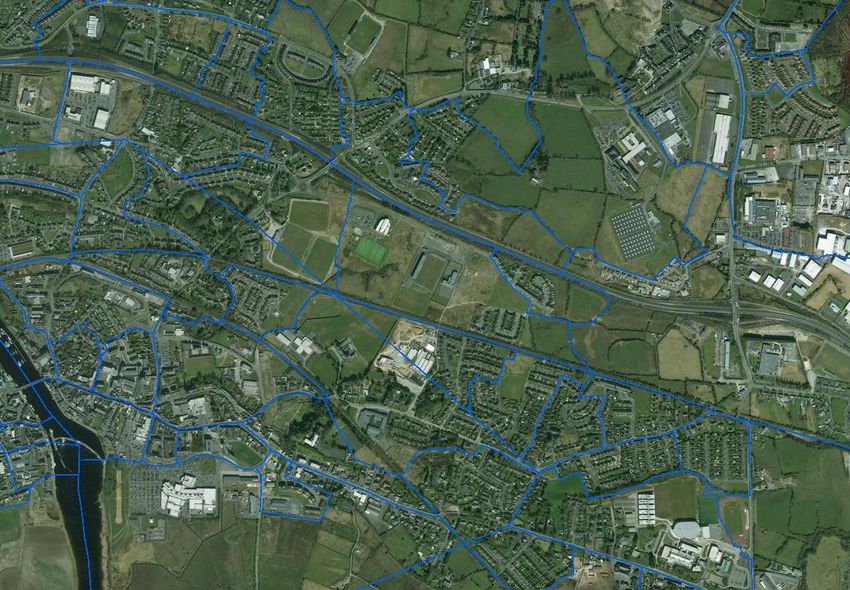
iv
Proposed Residential Development, Lissywollen, Athlone, Co. Westmeath
Mobility Management Plan

  7.4      CYCLING STRATEGY ......................................................................................... 62
  7.5      PUBLIC TRANSPORT STRATEGY ........................................................................ 64
  7.6      PRIVATE CAR STRATEGY .................................................................................. 66
  7.7      MARKETING AND PROMOTION STRATEGY ......................................................... 68

8.0     SUMMARY AND CONCLUSIONS ....................................................... 71
  8.1      SUMMARY ........................................................................................................ 71

DBFL Consulting Engineers                                                                                          p180176
v
Proposed Residential Development, Lissywollen, Athlone, Co. Westmeath
Mobility Management Plan

                                             APPENDICES

Appendix A                  Mode Specific Measures

Appendix B                  Management & Monitoring Measures

Appendix C                  Marketing & Promotion Measures

DBFL Consulting Engineers                                               p180176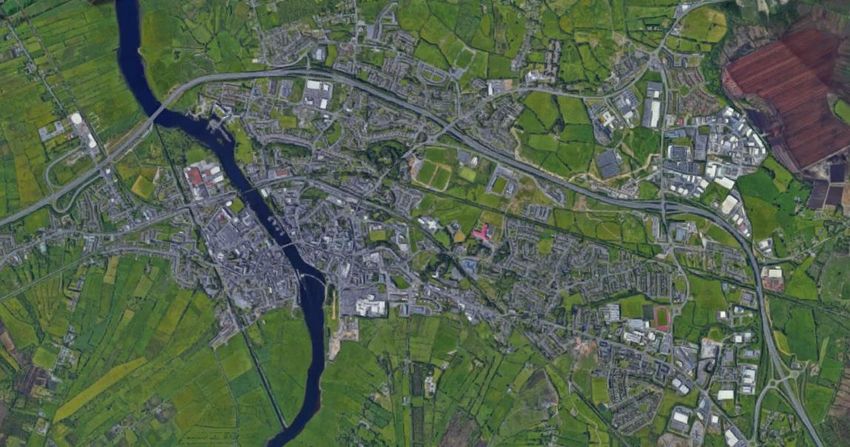
1
Proposed Residential Development, Lissywollen, Athlone, Co. Westmeath
Mobility Management Plan

                                                                         CHAPTER 1

                                                                        Introduction

                                                        1.1 CONTEXT
                                                        1.2 BACKGROUND
                                                        1.3 STRUCTURE OF REPORT

DBFL Consulting Engineers                                                      p180176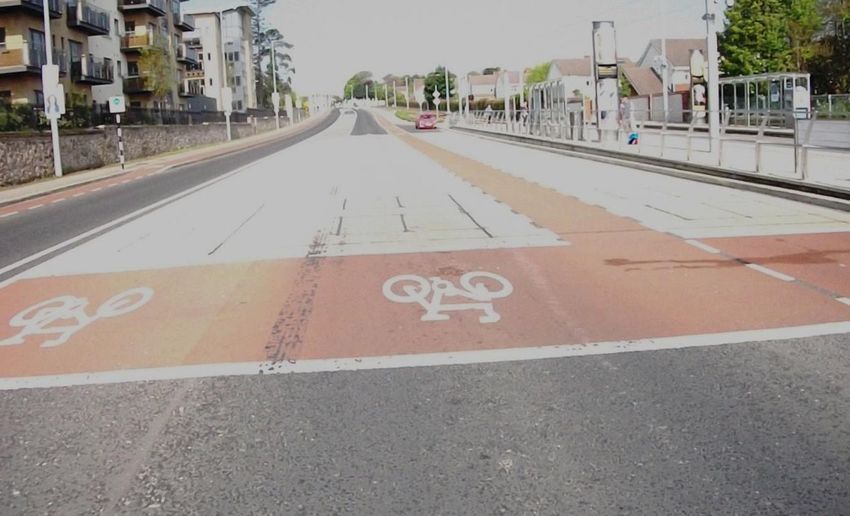
2
Proposed Residential Development, Lissywollen, Athlone, Co. Westmeath
Mobility Management Plan
1.0 INTRODUCTION
1.1 CONTEXT
1.1.1 DBFL Consulting Engineers (DBFL) have been commissioned by Alanna
Roadbridge Developments Ltd. to prepare a Mobility Management Plan (MMP)
for a proposed Strategic Housing Development on a site in Lissywollen,
Athlone, Co. Westmeath.
1.1.2 The proposals seek permission for the provision of 576 no. residential
dwellings, 2 no. creche facilities (321m2 and 448m2 GFA) and a community
hub (101m2 GFA). The residential dwellings comprise 246 no. apartment
units, 45 no. duplex units and 285 no. houses.
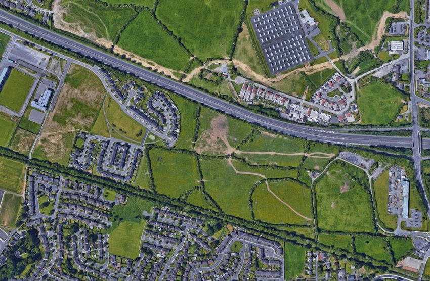
1.1.3 This site’s location may be seen with reference to its surrounding area in the
Site Location Map shown in Figure 1.1 below.
Subject Site
Figure 1.1: Site Location (Source : www.googlemaps.ie )
1.1.4 This MMP has been prepared to guide the delivery and management of several
coordinated initiatives which ultimately seek to encourage sustainable travel
practices for all journeys to and from the proposed development.
1.1.5 This framework document aims to inform three distinct audiences as follows;
DBFL Consulting Engineers p180176
3
Proposed Residential Development, Lissywollen, Athlone, Co. Westmeath
Mobility Management Plan

                •    The appointed Mobility Manager who will be responsible for
                     implementing and managing the MMP. Should the manager not be
                     overly familiar with the MMP process they will find the process and
                     context information as outlined in Chapter 2 invaluable. The MMP
                     targets and measures introduced in Chapter 5 and Chapter 6 will be
                     coordinated, administered and updated by the appointed Mobility
                     Manager.
                •    The Local Authority Officers who will be eager to ensure that the
                     MMP      initiatives    are     appropriately      ambitious,   deliverable   and
                     implemented fully. The officers, who will be very familiar with the MMP
                     process, will be predominately interested in the proposed MMP Targets
                     (Chapter 5) and associated measures (Chapter 6).
                •    The Residents of the proposed development who may be unfamiliar
                     with the MMP process. They will find the process and context
                     information as outlined in Chapter 2 invaluable. They may also be
                     interested in the MMP targets and measures introduced in Chapter 5
                     and Chapter 6.

1.2        BACKGROUND

1.2.1      This Mobility Management Plan (MMP) has been prepared to guide the
           delivery and management of a package of integrated initiatives which seek to
           encourage sustainable travel practises at the proposed Strategic Housing
           Development located in Lissywollen, Athlone, Co. Westmeath. This document
           aims to expand the awareness of and increase travel options for the residents,
           visitors and staff at the site and the wider community.

1.2.2      The Plan will be used mainly by the appointed Mobility Manager who will be
           responsible for implementing and managing the MMP for the benefits of the
           residents, visitors and staff who may be interested in reading this document
           to see how it directly affects them.

1.2.3      DBFL Consulting Engineers have prepared this MMP to guide the delivery and
           management of a package of integrated initiatives which ultimately seek to
           encourage sustainable travel practices of all residents and visitors travelling
           to/from the proposed development.

1.2.4      The purpose of the Mobility Management Plan is to:

DBFL Consulting Engineers                                                                     p180176
4
Proposed Residential Development, Lissywollen, Athlone, Co. Westmeath
Mobility Management Plan

                •    Provide a ‘manual’ and record for the Mobility Manager who will be
                     appointed to oversee the implementation and development of the
                     measures set out in the document,

                 •   Provide a formal record for the local authority in regard to the type,
                     scale and number of initiatives that the MMP initially proposes and
                     subsequently their level of success in subsequent versions of the MMP
                     which remains a ‘live’ document to be updated at least initially every
                     2 to 3 years following its implementation, and

                •    To provide a long-term strategy for encouraging residents, staff and
                     visitors to reduce their dependency on travelling by car in favour of
                     more sustainable modes of travel.

1.2.5      The aims of the MMP Framework are:

                        (a) To increase the awareness of residents, staff and visitors to all
                            the transport options available to them and to highlight the
                            potential for travel by more sustainable modes, and

                        (b) To introduce a package of both ‘hard’ (physical) and ‘soft’
                            (behavioural) measures that will facilitate travel by sustainable
                            modes of travel to/from the subject development site.

1.3        STRUCTURE OF REPORT

1.3.1      Following this introduction, the MMP framework including the definition of an
           MMP, its objectives, the scope and process involved in compiling and
           implementing such a plan is outlined in Chapter 2.

1.3.2      The environment within which the proposed development MMP is placed, such
           as location and local transportation system is briefly outlined in Chapter 3.

1.3.3      The MMP context in terms of local travel trends are established in Chapter
           4.

1.3.4      The MMP objectives and targets are established in Chapter 5.

1.3.5      In Chapter 6 the measures and travel initiatives selected to encourage
           sustainable travel are discussed. These include Mode Specific Measures,

DBFL Consulting Engineers                                                            p180176
5
Proposed Residential Development, Lissywollen, Athlone, Co. Westmeath
Mobility Management Plan

           Management Measures, Marketing Measures and Monitoring & Review
           Measures.

1.3.6      With the objective of establishing the basis for discussions with the local
           authority, from which an agreed MMP action plan can be adopted, Chapter
           7 presents a Preliminary Action Plan for the MMP at the development at
           Lissywollen in Athlone, Co. Westmeath.

1.3.7      The main conclusions and recommendations of the MMP are summarised in
           Chapter 8.

DBFL Consulting Engineers                                                     p180176
6
Proposed Residential Development, Lissywollen, Athlone, Co. Westmeath
Mobility Management Plan
CHAPTER 2
Mobility Management
Plan Framework
2.1 What is a Mobility Management Plan?
2.2 What is a Residential Development
MMP?
2.3 Who is Involved?
2.4 Objectives of an MMP
2.5 MMP Process
2.6 MMP Next Step
2.7 Policy Framework
DBFL Consulting Engineers p1801767
Proposed Residential Development, Lissywollen, Athlone, Co. Westmeath
Mobility Management Plan
2.0 MOBILITY MANAGEMENT PLAN FRAMEWORK
2.1 WHAT IS A MOBILITY MANAGEMENT PLAN?
2.1.1 The Dublin Transportation Office’s (which was subsumed into the National
Transportation Authority (NTA) in December 2009) 2001 publication entitled
“The Route to Sustainable Commuting” defines an MMP as “… a package of
measures put in place by an organisation to encourage and support more
sustainable travel patterns …”.
2.1.2 The MMP can be developed for an individual site or group of sites and is
designed specially to respond to a range of different site-specific land uses
such as business (offices, retail, industrial etc.), residential and schools/
colleges/ universities.
2.1.3 Whilst the emergence and successful application of MMPs have only
transpired over the last 15 years in Ireland, other countries have extensive
experience in designing, implementing, marketing and monitoring the
successful delivery of MMPs. Accordingly, MMPs are also known by a number
of other names including;
• Travel Plans;
• Green Travel Plans;
• Sustainable Mobility Plans; or
• Sustainable Commuter Plans.
2.2 WHAT IS A DEVELOPMENT MOBILITY MANAGEMENT PLAN?
2.2.1 A Development Mobility Management Plan is a package of measures designed
specifically to reduce the number and length of car-based trips, while also
encouraging more sustainable forms of travel and reducing the overall need
to travel. It sets out objectives and targets to achieve sustainable travel
patterns.
2.2.2 A successfully implemented MMP can provide reductions in car usage,
particularly influencing levels of single-occupancy car travel, with increased
trips made by public transport, walking and cycling; and improve road safety
and personal security (in particular for pedestrians and cyclists).
DBFL Consulting Engineers p1801768
Proposed Residential Development, Lissywollen, Athlone, Co. Westmeath
Mobility Management Plan
2.2.3 Mobility Management Plans to date have mainly focussed on the development
of destination MMP’s to encourage travel by sustainable modes for
employment and school developments. Destination MMPs (employment,
schools, buildings etc.) focus on a particular journey purpose while a
Residential MMP is concerned with journeys made from a single origin (home)
to multiple and changing destinations.
2.3 WHO IS INVOLVED?
2.3.1 A Mobility Management Plan impacts the following stakeholders who should
all be involved in some form or manner:
• Local Authority Officers,
• Property developers,
• Facility Management Personnel,
• Future residents at sites,
• Residents in the community surrounding new housing developments
with an MMP, and
• Transport Operators.
2.4 OBJECTIVES OF A MOBILITY MANAGEMENT PLAN
2.4.1 The principal objective of an MMP is to reduce levels of private car use in
parallel with encouraging people to walk, cycle, use public transport, car share
or even reduce the number of trips undertaken / required.
2.4.2 A comprehensive range of goals, and subsequent complementary secondary
level objectives, can be identified with the purpose of achieving the ultimate
objective of the MMP. This can be achieved through the delivery of a range
of complimentary integrated initiatives which can positively influence travel
behaviour and associated travel habits.
2.4.3 The specific objective(s) of an MMP can vary depending upon the
organisation, site characteristics and specific land uses which vary with each
site. Nevertheless, in the context of this MMP objectives can include;
a) For Residents and Staff –
• Address residents and staff’s need for access to a full range of facilities
DBFL Consulting Engineers p1801769
Proposed Residential Development, Lissywollen, Athlone, Co. Westmeath
Mobility Management Plan
for education, work, health, leisure, recreation and shopping; and
• Promote healthy lifestyles and sustainable, vibrant local communities.
b) The Local Community –
• Reduce the traffic generated by the development for journeys on the
external road network;
• Make local streets less dangerous, less noisy and less polluted;
• Enhance viability of public transport; and
• Improve the environment and the routes available for cycling and
walking.
2.5 MOBILITY MANAGEMENT PLAN PROCESS
2.5.1 Once the decision has been made to produce an MMP the process of compiling
the plan encompasses the 8 principal steps presented in graph in Figure 2.1
below.
(1) Identify
Team, Consult
& Survey
(8) Update &
(2) Collate &
Publish New
Analyse Info
Action Plan
COMPLETED
/ ON-GOING
Mobility (3) Identify
(7) Identify Management Objectives &
New Targets Plan (MMP) Targets
Process
PROPOSED
IMMINENT
(6) Monitor & (4) Develop
Review Action Plan
(5) Publish &
Launch MMP
Figure 2.1: MMP Development Process and Status
DBFL Consulting Engineers p18017610
Proposed Residential Development, Lissywollen, Athlone, Co. Westmeath
Mobility Management Plan
2.5.2 The MMP however remains an ‘active’ document which continues to evolve
and develop during its lifecycle. Accordingly, once the initial eight steps have
been successfully completed (including monitoring and reporting
requirements), the process recommences with the identification of new
actions and associated targets which instigates the second generation of the
MMP. As a result, subsequent generations of the MMP can be incorporated
into the management and operation of the residential development for as long
as necessary or potentially even for the entire existence of the development.
2.5.3 Once the development’s specific objectives are identified, “SMART” targets
will both assist in defining the specific measures that are included and / or
prioritised within the MMP (to reach the objective), and help with the
monitoring and evaluation of the level of success achieved by the MMP.
SMART targets, which can be agreed with the local authority should be;
Figure 2.2: SMART Targeting Principles
DBFL Consulting Engineers p18017611
Proposed Residential Development, Lissywollen, Athlone, Co. Westmeath
Mobility Management Plan
2.6 MOBILITY MANAGEMENT PLAN NEXT STEP
2.6.1 In the context of the development’s operational framework, the local receiving
environment and the identification of the Preliminary Action Plan this
document should form the basis by which;
(a) The subject development’s specific travel characteristics are
outlined and presented to the planning authority, and
(b) Through a partnership approach between the developers and the
local planning authority, the Preliminary Action Plan is explored and
re-examined with the objective of reaching agreement upon the
MMP’s measures and subsequently the adoption of an ‘agreed’ MMP
Action Plan with targets, initiatives, timescales, responsibilities and
resources clearly outlined and approved by both parties.
2.6.2 To enable this process to commence it is proposed that this MMP document,
as compiled by DBFL, is submitted to An Bord Pleanála as part of the
application. At the request of the local authority, a meeting between the local
authority officers and the developers can take place if required with the
objective of formally agreeing an MMP action plan and associated targets for
the subject residential development as proposed at the site at Lissywollen,
Athlone, Co. Westmeath.
2.7 POLICY FRAMEWORK
2.7.1 The MMP for the proposed Lissywollen development is supported by
comprehensive transport policy hierarchy in addition to being influenced
directly / indirectly by other policy themes (e.g. environmental, health etc.)
which generate a range of complementary policy instruments in addition to
demands and pressures that clearly necessitate a change in existing travel
behaviour. Commencing at EU level and subsequently transferred into
national policy and regulations in Ireland, the hierarchy continues from
regional (Westmeath County Council) to sub-region (Athlone Town) and
eventually arriving at site (e.g. Local Area Plan or land use) specific policy
objectives.
DBFL Consulting Engineers p18017612
Proposed Residential Development, Lissywollen, Athlone, Co. Westmeath
Mobility Management Plan
Westmeath County
Development Plan
Athlone Town
Development Plan
Lissywollen South
Framework Plan
Curragh-
Lissywollen North
LAP
Residential
Health MMP Environmental
Policy Policy
Figure 2.3: MMP Policy Framework and External Influences
National Smarter Travel Policy
2.7.2 ‘Smarter Travel - A Sustainable Transport Future’,
was published in February 2009, and represents a
new transport policy for Ireland for the period 2009-
2020. The policy recognises the vital importance of
continued investment in transport to ensure an
efficient economy and continued social development,
but it also sets out the necessary steps to ensure that
people choose more sustainable transport modes
such as walking, cycling and public transport.
2.7.3 The policy is a direct response to the fact that continued growth in demand
for road transport is not sustainable due to the resulting adverse impacts of
increasing congestion levels, local air pollution, contribution to global
warming, and the additional negative impacts to health through promoting
increasingly sedentary lifestyles.
2.7.4 The following five key goals form the basis of the Smarter Travel policy
document:
DBFL Consulting Engineers p18017613
Proposed Residential Development, Lissywollen, Athlone, Co. Westmeath
Mobility Management Plan
• Improve quality of life and accessibility to transport for all and, in
particular, for people with reduced mobility and those who may
experience isolation due to lack of transport.
• Improve economic competitiveness through maximising the efficiency
of the transport system and alleviating congestion and infrastructural
bottlenecks.
• Minimise the negative impacts of transport on the local and global
environment through reducing localised air pollutants and greenhouse
gas emissions.
• Reduce overall travel demand and commuting distances travelled by
the private car.
• Improve security of energy supply by reducing dependency on
imported fossil fuels.
2.7.5 These aims will be achieved through 49 specific actions, which can be broadly
grouped into 4 key areas:
• Actions to reduce distance travelled by private car and encourage
smarter travel,
• Actions aimed at ensuring that alternatives to the private car are more
widely available,
• Actions aimed at improving the fuel efficiency of motorised transport
through improved fleet structure, energy efficient driving and
alternative technologies, and
• Actions aimed at strengthening institutional arrangements.
2.7.6 The opportunities and potential benefits that could be achieved by the
implementation of an MMP are considered under the policy goal of
encouraging Smarter Travel.
2.7.7 The Smarter Travel policy also includes for a comprehensive range of
supporting ‘actions’ including mode specific (e.g. walking, cycling and public
transport etc.) and behaviour change initiatives which both encourage and
provide for sustainable travel practices for all journeys.
Athlone Town Development Plan 2014-2020
2.7.8 The Athlone Town Development Plan 2014-2020 sets out the “overall strategy
for the proper planning and sustainable development of the administrative
DBFL Consulting Engineers p18017614
Proposed Residential Development, Lissywollen, Athlone, Co. Westmeath
Mobility Management Plan
area and immediate environs of Athlone Town for the period 2014 to 2020,
together with the provision of policies and objectives for the future
development of the town and environs”.
2.7.9 Objective O-TM9 within the Development Plan states that “it is an objective
of the Councils “to require Mobility Management Plans to be submitted with
applications for trip intensive developments.”
Lissywollen South Framework Plan 2018-2024
2.7.10 The Lissywollen South Framework Plan 2018-2024 “provides a development
strategy for the proper planning and sustainable development of the
Lissywollen South area in Athlone in accordance with the policies and
objectives of the Athlone Town Development Plan 2014-2020”.
2.7.11 Map 4 of the Framework Plan illustrates the Land Use zoning of the lands
bounded by the LAP. An extract of Map 1 is provided in Figure 2.4 below
and reveals that the lands on which the subject scheme proposals lies are
zoned “Proposed Residential”.
Subject Site
Figure 2.4: Lissywollen Land Use Zoning (extract from Map 4 of the Lissywollen South
Framework Plan 2018-2024)
2.7.12 Section 3.6 of the Framework Plan sets out the Access & Movement strategy
for the Plan area. It is highlighted that “It is important that the design of the
transport network should reflect urban design qualities and not just traffic
considerations - free movement and promoting choice for the user are key
DBFL Consulting Engineers p18017615
Proposed Residential Development, Lissywollen, Athlone, Co. Westmeath
Mobility Management Plan
elements in positive urban design. New routes should connect into existing
routes and movement patterns with pedestrian links following established
desire lines and short-cuts across the plan area to ensure ease of movement”.
2.7.13 The main transport related objectives in the Plan are summarised below;
Lissywollen Avenue (East-West Road Link)
Objective O-AM1: “To provide a new and extended east west Lissywollen
Avenue in the form of an urban boulevard linking and unifying all parts of the
plan area.”
Objective O-AM2: “To integrate a secondary network of streets with
Lissywollen Avenue and the existing street network.”
North-South Avenue
Objective O-AM3: “To provide a new North-South Avenue connecting Retreat
Road with the Lissywollen Avenue via the Old Rail Trail. Said route shall give
priority to buses, cyclists and pedestrians and shall be sited so as not to
adversely impact upon the landscape setting of the Marist School”
Public Transport
Objective O-AM8: “To provide for a bus service to serve the plan area.”
Walking & Cycling
Objective O-AM4: “To promote and support a culture of sustainable travel in
conjunction with the local schools and AIT, whilst maximising the user
potential of the Old Rail Trail”
Objective O-AM5: “To provide an integrated and permeable network of streets
with high quality pedestrian and cycle networks, maximising linkages within
the area, to the Old Rail Trail and to the wider environs”
Objective O-AM6: “To create a network of safe and attractive streets
structured around a compact and walkable layout to ensure ease of
movement”
Objective O-AM7: “To provide for a high quality safe pedestrian and cycle
network within the Plan Area with high levels of permeability, passive
surveillance and supervision and to ensure that this network will provide
DBFL Consulting Engineers p18017616
Proposed Residential Development, Lissywollen, Athlone, Co. Westmeath
Mobility Management Plan
attractive, legible and direct links to the Town Centre, AIT, the Regional
Sports Centre, Bus Stops and the wider environs.”
Objective O-AM9: “To promote the creation of a 5km walking/running circuit
within Lissywollen, in the interests of quality of life and promoting healthy
communities.”
Objective O-AM14: “To consider the provision of a Park and Stride facility
within the Plan area.”
2.7.14 Map 3 of the Plan highlights the aforementioned objectives as presented in
Figure 2.5 below.
Objective O-AM3
Objective O-AM1
Figure 2.5: Lissywollen Access & Movement Strategy (extract from Map 3 of the
Lissywollen South Framework Plan 2018-2024)
Curragh-Lissywollen North LAP 2006
2.7.15 The Curragh-Lissywollen North LAP 2006 aims to;
• “Provide a coordinated framework for the future development of the
lands which are zoned ‘Residential’, ‘Industrial’, and ‘Educational’,
‘Light Industrial Technological’, and some ‘Commercial’.
• Determine a distribution road network for the area.
• Facilitate development that integrates with the existing northeast area
of Athlone’s Environs.
DBFL Consulting Engineers p18017617
Proposed Residential Development, Lissywollen, Athlone, Co. Westmeath
Mobility Management Plan
• Identify the services, infrastructure and amenities required to serve
the area”.
2.7.16 While not directly related to the subject site, the LAP considers the provision
of a strategic link “from the Curragh and Lissywollen North areas into the
proposed Cornamaddy residential area to the north and the Lissywollen
residential quarter to the south”.
2.7.17 Map 5 of the LAP presents the “Future Land Use Concept” and illustrates a
proposal for a pedestrian / cycle bridge over the N6 linking Northern and
Southern Lissywollen.
Proposed Pedestrian / Cycle Bridge
Figure 2.6: Future Land Use Concept (extract from Map 5 of the Curragh-Lissywollen
North LAP 2016)
DBFL Consulting Engineers p18017618
Proposed Residential Development, Lissywollen, Athlone, Co. Westmeath
Mobility Management Plan
CHAPTER 3
Site Description &
Existing Conditions
3.1 SITE DESCRIPTION
3.2 PROPOSED DEVELOPMENT
3.3 EXISTING TRANSPORT FACILITIES & SERVICES
3.4 PROPOSED TRANSPORT FACILITIES
DBFL Consulting Engineers p18017619
Proposed Residential Development, Lissywollen, Athlone, Co. Westmeath
Mobility Management Plan
3.0 SITE DESCRIPTION & EXISTING CONDITIONS
3.1 SITE DESCRIPTION
3.1.1 The subject site is located approximately 1km to the northeast of Athlone
Town Centre. The subject site is generally bounded to the north by the N6
which connects Kinnegad to Galway, while to the south the site is bounded
by the Old Rail Trail Greenway which forms part of the Dublin-Galway National
Cycle Network. To the west, the site is bounded by Scoil na gCeithre Máistrí
primary school and the facilities of the Athlone Regional Sports Centre. The
eastern boundary of the site is defined by an old boreen road (Blackberry
Lane).
3.1.2 The general location of the subject site in relation to the surrounding road
network is illustrated in Figure 3.1 below whilst Figure 3.2 indicatively
shows the extent of the subject site boundary and neighbouring lands.
Subject Site
Figure 3.1: Site Location (Reference: Google Maps)
DBFL Consulting Engineers p18017620
Proposed Residential Development, Lissywollen, Athlone, Co. Westmeath
Mobility Management Plan
Subject Site
Figure 3.2: Extent of Site Indicative Boundary (Reference: Google Maps)
3.2 PROPOSED DEVELOPMENT
3.2.1 The proposals seek permission for the provision of a 576-unit residential
development plus 2 no. crèche facilities (321m2 & 448m2 GFA) and a
community hub (101m2) over two parcels of land at Lissywollen, Athlone. The
proposed 576 no. residential units comprise 291 no apartment / duplex units
and 285 no. housing units.
3.2.2 Further details of the development proposals including the site layout and
transport network arrangements are illustrated in the architects’ scheme
layout and engineering drawings as submitted with this planning application.
The full development description can also be found in the planning report
accompanying the application.
Site Access Arrangements
3.2.3 Access to the subject site will be from Ballymahon roundabout (on the R915)
to the west via Brawny Road and Garrycastle roundabout (on the R916) to
the east. The development proposal includes for road development works and
the construction of an east-west access route through the subject site from
Ballymahon roundabout (on the R915) to the west to Garrycastle roundabout
DBFL Consulting Engineers p18017621
Proposed Residential Development, Lissywollen, Athlone, Co. Westmeath
Mobility Management Plan
(on the R916) to the east. The development proposal provides for pedestrian
and cyclist connectivity to Old Rail Trail Greenway to the south.
3.2.4 The development proposes 5 no. new formal cycle / pedestrian access points
between the masterplan lands and the Old Rail Trail Greenway to the south
of the development site subsequently ensuring excellent cycle / pedestrian
accessibility.
Pedestrians and Cyclists Infrastructure
3.2.5 As introduced above, the subject site will be highly accessible to pedestrians
and cyclists. Pedestrians and cyclists will be given priority within the internal
site layout to ensure travel desire lines within the site are accommodated
providing a good level of service and ensures the risk of vehicle/pedestrian
conflict is minimised.
3.2.6 There has been a number of consultation meetings undertaken with the
existing local residents in parallel with the local authority. The feedback
received from these meetings has actively influenced and shaped the design
of the proposed development including the locations and alignment of
pedestrian/cycle connections through the site with external travel desire lines
and the location of formal controlled pedestrian/cycle crossing points at key
locations along the main east-west ‘Avenue’ corridor.
3.2.7 Dedicated pedestrian/cycle paths are proposed throughout the site layout
providing a traffic free route between the different sections of the
development site. Furthermore, pedestrian facilities are proposed on two
sides and two-way cycle facilities on one side of the extended Brawny Road
corridor.
3.2.8 The integration of the proposed masterplans street network with the existing
Old Rail Trail Greenway with 5 no. permeable connections, located to the
south of the subject site) provided for with the objective of maximising
accessibility for walking and cycling journeys.
3.2.9 A total of six TOUCAN controlled crossing facilities (Zebra) are proposed along
the new east-west spine road each located on key pedestrian / cycle travel
desire routes. These formal facilities, supplemented by courtesy crossings,
will provide a high degree of permeability with safe crossing points integrating
DBFL Consulting Engineers p18017622
Proposed Residential Development, Lissywollen, Athlone, Co. Westmeath
Mobility Management Plan
the residential areas located to the north and south of the new ‘Avenue’ street
corridor.
Proposed Cycle Track
Proposed shared cycle/ped facility
All Modes of Travel
Proposed Cycle / Ped Access
Existing Cycle / Ped Access
Zebra Crossing
Future N6 Ped/Cycle Overbridge
Figure 3.3: Site Layout and Pedestrian/Cycle Accessibility
3.2.10 As per the objectives of the Curragh-Lissywollen LAP (to the north) the layout
of the subject application has been designed to ensure that the potential for
future connections across the N6 (i.e. a pedestrian/cycle overbridge) is
maintained.
3.2.11 The planning application also includes for the provision of new bicycle
infrastructure off-road along Brawny Road and Blackberry Lane corridors
linking the subject development lands with the existing bicycle infrastructure
at the R915/east. This new bicycle infrastructure will benefit new residents of
the proposed development to access work, leisure and education facilities to
the northwest and northeast in addition to providing new sustainable routing
opportunities for both existing residents of the area and visitors / patrons of
the leisure facilities currently located along Brawny Road.
DBFL Consulting Engineers p18017623
Proposed Residential Development, Lissywollen, Athlone, Co. Westmeath
Mobility Management Plan
Internal Road Layout
3.2.12 The proposed residential scheme’s internal road layout has been designed to
respect the principles and guidance outlined within the Design Manual for
Urban Roads and Streets (DMURS) 2013 (updated May 2019). The scheme
proposals are the outcome of an integrated design approach that seeks to
implement a sustainable community connected by well-designed streets
which deliver safe, convenient and attractive networks.
3.2.13 The adopted design approach incorporates traditional road design along with
elements of urban design and landscaping to create lower traffic speeds and
thereby facilitate a safer road environment for pedestrians and cyclists. DBFL
along with the rest of the design team have interrogated the DMURS principles
to ensure that the final layout provides for a package of self-regulating design
measures providing a high quality urban extension in proximity to Athlone
Town Centre. Further details can be found in the DMURS Compliance
Statement enclosed with this application.
3.2.14 The proposals incorporate a hierarchy of internal streets which are firmly set
within the context of the local Athlone receiving environment. The existing
road network in Athlone includes Arterial links such as the N6 to the north,
the N55 to the northwest and the N62 and N61 corridor as located to
southeast and west of the subject site respectively. Link streets bordering the
site, such as R915 Ballymahon Road, and R916 Wash House Road provide the
connections between the proposed development, the above Arterial links, and
town centre.
3.2.15 In contrast, the internal road network within the site, as illustrated in Figure
3.4 has been designed to deliver a hierarchy of link and local streets that
provide appropriate access within / across the proposed new residential
communities and the road network external to the site. The movement
function and design of each internal street network has sought to respect the
different levels of motorised traffic whilst optimising access to/from public
transport and prioritising the movement of higher number of pedestrians and
cyclists. In parallel the adopted DMURS design philosophy has sought to
consider the context / place status of each residential local street in terms of
level of connectivity provided, quality of the proposed design, level of
DBFL Consulting Engineers p18017624
Proposed Residential Development, Lissywollen, Athlone, Co. Westmeath
Mobility Management Plan
pedestrian / cyclists activity and vulnerable users requirements whilst
identifying appropriate ‘transition’ solutions between different street types.
Street Type 1 : ‘The Avenue’ (LINK Street) – 30kph Design Speed …
Street Type 2 : Primary LOCAL Street – 20kph Design Speed ……...
Street Type 3 : Secondary LOCAL Street – 20kph Design Speed …..
Street Type 4 : Shared Surface ‘Homezone’ – 20 kph Design Speed
Street Type 5 : Private Parking Courtyard – 10-15 kph Design Speed
Existing Street within the area-wide street hierarchy ……………………….
Vehicle Access to Development Masterplan Lands …………………………...
No Vehicle Through Route (Pedestrians and cyclists only) …………………
Figure 3.4: Proposed Developments Street Hierarchy
3.2.16 In reference to Figure 3.4 above the proposed residential scheme’s hierarchy
of internal streets can be summarised as follows:
• The Avenue – LINK Street – this is a 6m wide carriageway with a 30kph
design speed through the masterplan development lands. Segregated
cycle tracks and footways are proposed to the north and / or south of
this Link street.
DBFL Consulting Engineers p18017625
Proposed Residential Development, Lissywollen, Athlone, Co. Westmeath
Mobility Management Plan
• Primary LOCAL Street – these are narrower 5.5m wide streets with a
20kph design speed branching off the aforementioned Link street
provide access to the new residential areas.
• Secondary LOCAL Street – 5.5m wide carriageway with a 20kph design
speed.
• ‘Homezone’ – 20kph design speed.
• Private Parking Courtyard – 10-15kph design speed.
3.2.17 The street layout was derived from several factors which include, the distinct
shape of the site, boundary conditions and travel desire lines. This has led to
the creation of a street network that comprises elements of an orthogonal
and organic layout in specific areas. As part of the design and development
of the street network, cycle and pedestrian linkages were prioritised around
the development to link existing developments. Further details are outlined in
the applications DMURS Compatibility Statement.
3.3 EXISTING TRANSPORT FACILITIES & SERVICES
Road Network
3.3.1 The subject development is accessed via Brawny Road. At the western extent
of the Brawny Road corridor is the Brawny Road / R915 / N55 / One Mile
Round roundabout junction. Travelling in a southbound direction along the
R915 provides access to Athlone Town Centre. Travelling northbound from
the aforementioned roundabout along the N55 leads to the N6 road corridor
and subsequently the strategic M6 motorway. The strategic M6 motorway
provides access to destinations including Ballinasloe, Athenry and Galway to
the west and Kilbeggan, Tyrrelspass, Kinnegad to the east before joining the
M4 motorway leading to Dublin City and intermediate destinations.
3.3.2 Continuing north on the N55 from the N6 interchange leads to destinations
including Glasson, Ballymahon, Carrickboy and Edgeworthstown.
Existing Pedestrian and Cycling Facilities
3.3.3 The Old Rail Trail Greenway is located to the south of the development lands
and operates in and East-West direction adjacent to the disused rail line. This
facility is approximately 40km long and currently operates between the R195
DBFL Consulting Engineers p18017626
Proposed Residential Development, Lissywollen, Athlone, Co. Westmeath
Mobility Management Plan
in Athlone (to the west of the development site) and Mullingar to the east. It
is easily accessible via a dedicated access link which is positioned along the
western boundary of the proposed developments smaller plot. Furthermore,
access for pedestrians / cyclists can be gained to Athlone Community College
and Our Lady’s Bower Secondary School (and subsequently Athlone Town
Centre by continuing along Lower Road) via an access on the opposite side
of the greenway as illustrated in Figure 3.4A and Figure 3.4B below.
Development Site Boundary
Existing Old Rail
Trail Greenway
Future Extension of Old Rail Trail
Greenway including new pedestrian /
bridge across the River Shannon
Figure 3.4A: Old Rail Trail Greenway
DBFL Consulting Engineers p18017627
Proposed Residential Development, Lissywollen, Athlone, Co. Westmeath
Mobility Management Plan
Subject Site
The Old Rail Trail
Greenway
Figure 3.4B: Existing Formal Access to / from the Old Rail Trail Greenway
3.3.4 Brawny Road, which provides a connection between the R915 and the subject
site benefits from good quality footways on both sides of the corridor and
benefits from traffic calming measures including speed tables at a number of
junctions and intermediate locations along the link as illustrated in Figure
3.5 below.
Speed Table
Speed Table
Figure 3.5: Pedestrian Facilities and Traffic Calming Measures along
Brawny Road
DBFL Consulting Engineers p18017628
Proposed Residential Development, Lissywollen, Athlone, Co. Westmeath
Mobility Management Plan
3.3.5 On all approaches to the Brawny Road / R915 / N55 / One Mile Round
roundabout junction, as located at the western extent of Brawny Road,
dedicated pedestrian footways are available on both sides of the corridors in
addition to dedicated cycle tracks on all arms along the immediate approaches
to the roundabout (Figure 3.6).
Cycle track / Footway at
roundabout junction
Footways on all
approaches Footways on all
approaches
Cycle track / Footway at
roundabout junction
Figure 3.6: Pedestrian and Cycle Facilities at Brawny Road / R915 / N55 /
One Mile Round Roundabout
Public Transport – Bus
3.3.6 The subject site benefits from good public transport accessibility levels. Bus
Eireann operates 2 number town services (A1 and A2) both of which operate
between Monksland and Greggan but along different routes. Both the A1 and
A2 services are within walking distance of the subject site with the nearest
interchanges located approximately 600m (A2) and 750m (A1) walking
distance from the site as detailed in Figure 3.7 below. Furthermore, 3 no.
‘local link’ services are accessible at Athlone Institute of Technology as located
approximately 1.6km from the subject site. These ‘local link’ services provide
access to destinations including Moate, Roscrea, Shannonbridge, Pollagh and
Kilcormac. A summary of the aforementioned bus services is presented in
Table 3.1 below.
DBFL Consulting Engineers p18017629
Proposed Residential Development, Lissywollen, Athlone, Co. Westmeath
Mobility Management Plan
Subject Site
Bus Eireann Route A2
Bus Eireann Route A1 Local Link Route 914
800m Catchment Area
Irish Rail
Local Link Route 925, 927
Garrankesh Athlone,
Subject Site Co. Westmeath,
Approx. 600m From Site
Bus Eireann Bus Stop
Cartrontroy Cypress Gardens,
Athlone, Co. Westmeath,
Approx. 0.75km From Site
Southern Station Rd, Athlone,
Cloghanboy West Co. Westmeath,
Bus Eireann Bus Stop
Approx. 1.8km From Site
Athlone Train St.
Garrycastle, Athlone,
Co. Westmeath,
Approx. 1.6km From Site
Local Link Bus Stop
Figure 3.7: Public Transport Connectivity – Local Bus Services
DBFL Consulting Engineers p18017630
Proposed Residential Development, Lissywollen, Athlone, Co. Westmeath
Mobility Management Plan
Provider Route Description Mon-Fri Sat Sun
Monksland – Creggan Court 27 24 12
Bus Eireann
A1
Creggan Court – Monksland 27 25 12
Monksland – Creggan Court 26 24 12
A2
Creggan Court – Monksland 25 23 11
Roscrea - Moate 1 - -
907
Moate - Roscrea 2 - -
Local Link
Shannonbridge - Athlone - 1 -
914
Athlone - Shannonbridge - 1 -
Pollagh - Athlone 1 - -
1925 (a)
Athlone – Kilcormac 2 - -
Table 3.1: No of Local Bus Services per day
3.3.7 Three no. regional bus services serve Athlone including Bus Eireann services
70 and 73 which is accessible at Athlone Bus Station (2km from subject site)
and Citylink service 763 as accessible at AIT (1.6km from subject site). Bus
Eireann route 70 operates between Galway and Dundalk whilst route 73
operates between Waterford / Carlow and Longford. The Citylink 763 service
operates between Galway and Dublin Airport. A summary of the
aforementioned bus services is presented in Figure 3.8 and Table 3.2
below.
Provider Route Description Mon-Fri Sat Sun
Galway / Athlone – Dundalk 4 3 2
Bus Eireann
70
Dundalk – Galway / Athlone 4 3 2
Waterford / Carlow – Longford 2 2 2
73
Longford – Waterford 2 2 1
Galway - Dublin Airport 8 8 8
Citylink 763
Dublin Airport – Galway 8 8 8
Table 3.2: No of Regional Bus Services per day
DBFL Consulting Engineers p18017631
Proposed Residential Development, Lissywollen, Athlone, Co. Westmeath
Mobility Management Plan
Bus Eireann Route 70
Citylink 763
Subject Site
Bus Eireann Route 73
800m Catchment Area
Irish Rail
Southern Station Rd, Athlone,
Cloghanboy West Co. Westmeath,
Approx. 1.8km From Site
Athlone Train St. Subject Site
Garrycastle, Athlone,
Co. Westmeath,
Approx. 1.6km From Site
Gerraghty’s Bus Stop
Southern Station Rd, Athlone,
Cloghanboy West Co. Westmeath,
Approx. 2.0km From Site
Shared Bus Stop
Figure 3.8: Public Transport Connectivity – Regional Services
DBFL Consulting Engineers p18017632
Proposed Residential Development, Lissywollen, Athlone, Co. Westmeath
Mobility Management Plan
Public Transport – Rail
3.3.8 Athlone train station is located approximately 2km from the subject site via
the R915 (by all modes) and 1.4km away via the Old rail Trail Greenway
(pedestrian / cyclists).
3.3.9 This station is serviced by 2 no. rail services including;
• Dublin Heuston to / from Galway, and
• Dublin Heuston to / from Westport and Ballina
3.3.10 A summary of the aforementioned services are presented in Table 3.3 below.
Destination Mon – Thur Fri Sat Sun
Dublin to Galway 10 10 10 6
Galway to Dublin 11 11 9 6
Dublin to Westport and Ballina 4 5 4 4
Westport and Ballina to Dublin 5 5 5 4
Table 3.3: Athlone Train Station Services
Figure 3.9: Rail Network
3.4 LOCAL AMENITIES
3.4.1 As illustrated in Figure 3.10, the proposed development site is well placed
in terms of the availability of and access to local amenities. There are 6
DBFL Consulting Engineers p18017633
Proposed Residential Development, Lissywollen, Athlone, Co. Westmeath
Mobility Management Plan
number primary schools and 4 no. post primary schools within 5km of the
subject site. Athlone IT is located only 1.5km to the southeast. The subject
site benefits from good access to local retail and leisure facilities including
Athlone Regional Sports Complex located only 550m to the west along Brawny
Road. Furthermore, the subject development site is well places to benefit from
local employment opportunities at Blyry Industrial estate to the northeast and
Monksland Industrial Park / Daneswell Business Park / Westpoint Business
Park located to the west via the N6/M6.
Subject Site
Blyry
Industrial
Estate
Westpoint
Business Park
Monksland
Industrial
Park
National School Secondary School
Shops Leisure
Employment 3rd Level
Figure 3.10: Local Amenities
3.5 PROPOSED TRANSPORT FACILITIES
Cycle / Walking Proposals
3.5.1 It is an objective of the Athlone Town Development Plan 2014-2020 (O-WC16)
“To provide a walking/cycling route from the Athlone Mullingar railway line in
Athlone, to the River Shannon, via a new bridge over the Shannon to the west
bank and onwards to the Roscommon County boundary, with the potential to
connect to Athlone Castle and southwards around the town”.
3.5.2 The Westmeath County Council proposed extension of the Old Rail Trail
Greenway as far as the River Shannon is expected to be operational within
the next 12 months (i.e. by August 2021). The future pedestrian / cycle bridge
over the River Shannon within the next 3-4 years (funded by the NTA).
DBFL Consulting Engineers p18017634
Proposed Residential Development, Lissywollen, Athlone, Co. Westmeath
Mobility Management Plan
3.5.3 Another objective of the development plan is “To provide north-south
pedestrian and cycle linkages between Curragh-Lissywollen and Lissywollen
South/Retreat, to overcome barriers to access and movement created by the
N6 and rail lines”.
Public Transport Proposals - Bus
3.5.4 Bus services are considered a “key player in offering an alternative to the
private car” within the development plan. The provision of a Quality Bus
Corridor is considered to be a possibility within Athlone Town in the future.
3.5.5 In compliance with the objectives of the Lissywollen South Framework Plan
2018-2024, the proposed development caters for an east-west access route
through the subject site connecting the R915 (to the west) to the (R916) to
the east. This east-west avenue has been designed to facilitate the existing
local bus route A2 to extend eastwards into the subject development lands
beyond its existing extents at Athlone Regional Sports Centre (Reference
Section 4.3 for more details).
Public Transport Proposals - Rail
3.5.6 The development plan highlights the potential for the reopening of the rail
link between Athlone and Mullingar and acknowledges that “would serve to
further strengthen public transport interconnectivity by connecting the
Galway/Mayo rail line with the Sligo rail line and potentially provide an
additional line option for the Galway-Dublin service. This would also facilitate
greater accessibility to Athlone and connectivity within the county and also on
a national level providing improved cross linkages, with services to the two
main stations in the capital and enabling increases on the Galway Dublin rail
line. The Councils are committed to supporting and facilitating the re-opening
of the Athlone to Mullingar rail line”.
Road Infrastructure Proposals
3.5.7 A new link road is proposed to the east of Athlone Town known as the
Loughandonning Link Road and will provide a local road link between The
Creggan LAP lands and Athlone Town Centre.
3.5.8 The Westmeath County Council proposed North / South link between Brawny
Road and Retreat Road, once implemented sometime in the future, will “give
DBFL Consulting Engineers p18017635
Proposed Residential Development, Lissywollen, Athlone, Co. Westmeath
Mobility Management Plan
priority to buses, cyclists and pedestrians and shall be sited so as not to
adversely impact upon the landscape setting of the Marist School “.
DBFL Consulting Engineers p18017636
Proposed Residential Development, Lissywollen, Athlone, Co. Westmeath
Mobility Management Plan
CHAPTER 4
Commuter Trends &
Transport Needs
4.1 INTRODUCTION
4.2 SUBJECT SITE PROPOSED
MODAL SPLIT
DBFL Consulting Engineers p18017637
Proposed Residential Development, Lissywollen, Athlone, Co. Westmeath
Mobility Management Plan
4.0 COMMUTER TRENDS & TRANSPORT NEEDS
4.1 INTRODUCTION
4.1.1 It is important where feasible to establish travel trends and area specific
transport needs when initially developing a MMP. The subject site is located
in close proximity to employment, retail and leisure opportunities at
Lissywollen and currently surrounded by residential developments with other
amenities including educational facilities within walking distance.
4.1.2 It is necessary to predict the nature of the proposed traffic to / from the site
and investigate whether it is possible to influence the modal split of the
commuters from the proposed development.
4.1.3 Varying demographic profiles that have an immediate impact on the traffic
network are commuters commuting to / from home as well as other journeys
such as school pick up / drop off and shopping trips. These can have their trip
patterns influenced. Visitors are more difficult to influence in their trip patterns
as they can be unpredictable.
4.1.4 In general, the current modal split for the Athlone area is indicated in the
Figures 4.1 and 4.2 below.
car driver, 65.7%
car passenger, 7.6%
m/cycle/
scooter,
0.3% on foot, 13.8%
train, 1.3%
bus/ minibus/ van, 4.4%
coach, 4.0%
bicycle, 3.1%
Figure 4.1: Current Modal Split in Athlone Area (2016) – Travel to Work
(source: www.census.cso.ie/sapmap/ – 2016 census data)
DBFL Consulting Engineers p180176You can also read