MOBILITY MANAGEMENT PLAN - Proposed Strategic Housing Development, Former Bailey Gibson Site, 326-328 South Circular Road, Dublin 8 - Bailey ...
←
→
Page content transcription
If your browser does not render page correctly, please read the page content below
MOBILITY MANAGEMENT PLAN
Proposed Strategic Housing Development,
Former Bailey Gibson Site,
326-328 South Circular Road, Dublin 8

                                            MAY 2020

     SYSTRA Reference number 30054513

                                          AUGUST 2019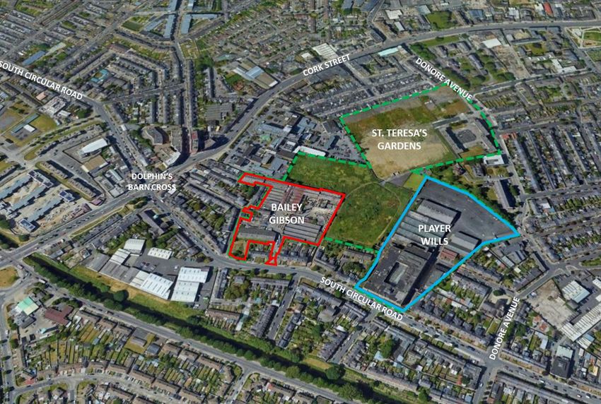
BAILEY GIBSON SHD RESIDENTIAL MOBILITY PLAN
DOCUMENT CONTROL SHEET

   IDENTIFICATION TABLE
                                DBTR-SCR1 Fund, a Sub-Fund of the CWTC Multi Family ICAV
    Client/Project owner

                                Proposed Strategic Housing Development,
    Project                     Former Bailey Gibson Site,
                                326-328 South Circular Road, Dublin 8
    Study                       Residential Mobility Management Plan

    Type of document            Final Report

    Date                        18/05/2020

    Reference number            30054513-REP-003

    Number of pages             56

   APPROVAL
   Version    Name                    Position              Date            Modifications
                           Alison     Associate
              Author                               12/06/2019
                           Pickett    Director
              Checked      Allanah    Project
      1                                            30/10/2019               Client Review
              by           Murphy     Manager
              Approved     Andrew
                                      Director     05/11/2019
              by           Archer
                           Alexis     Assistant
              Author                               16/01/2020
                           Hameau     Consultant
              Checked      Allanah    Project
      2                                            16/01/2020               Client Review
              by           Murphy     Manager
              Approved     Andrew
                                      Director     16/01/2020
              by           Archer
                           Alexis     Assistant
              Author                               21/04/2020
                           Hameau     Consultant
                                                                            Address Pre-
              Checked      Allanah    Project
      3                                            21/04/2020               App Opinion
              by           Murphy     Manager
                                                                            Comments
              Approved     Andrew
                                      Director     21/04/2020
              by           Archer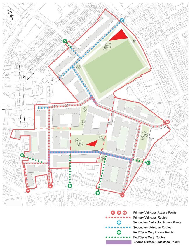
TABLE OF CONTENTS

1.              INTRODUCTION                                                                                           6
1.1             BACKGROUND                                                                                             6
1.2             SITE OVERVIEW                                                                                          6
1.3             MOBILITY MANAGEMENT PLAN APPROACH                                                                      7
1.4             REPORT STRUCTURE                                                                                       7

2.              MOBILITY MANAGEMENT: CONTEXT                                                                           8
2.1             WHAT IS MOBILITY MANAGEMENT?                                                                           8
2.2             THE BENEFITS OF MOBILITY MANAGEMENT                                                                    8
2.3             MOBILITY MANAGEMENT PLAN OBJECTIVES                                                                    8
2.4             MAKING RESIDENTIAL MOBILITY MANAGEMENT PLANS WORK                                                      9

3.              THE POLICY AND PLAN CONTEXT                                                                        10
3.1             POLICY AND PLAN OVERVIEW                                                                           10
3.2             NATIONAL POLICY CONTEXT                                                                            10
3.3             REGIONAL AND LOCAL POLICY CONTEXT                                                                  12

4.              THE PROPOSED DEVELOPMENT                                                                           19
4.1             OVERVIEW                                                                                           19
4.2             INTERNAL PEDESTRIAN AND CYCLIST PROVISION                                                          21
4.3             CYCLE PARKING                                                                                      23
4.4             CYCLE HIRE                                                                                         25
4.5             VEHICULAR ACCESS                                                                                   25
4.6             CAR PARKING                                                                                        26
4.7             SERVICES AND FACILITIES TO REDUCE THE NEED TO TRAVEL                                               27

5.              BASELINE REVIEW: EXISTING TRANSPORT NETWORK                                                        28
5.1             OVERVIEW                                                                                           28
5.2             THE SITE                                                                                           28
5.3             WALKING ACCESSIBILITY & INFRASTRUCTURE                                                             28
5.4             CYCLING ACCESSIBILITY & INFRASTRUCTURE                                                             35
5.5             PUBLIC TRANSPORT INFRASTRUCTURE                                                                    39
5.6             ROAD NETWORK                                                                                       40

6.              PRE – OCCUPATION BASELINE MODE SHARE                                                               41
6.1             PURPOSE OF THE BASELINE                                                                            41

Mobility Management Plan
Proposed Strategic Housing Development, Former Bailey Gibson Site, 326-328 South Circular Road, Dublin 8   Page 3/56
6.2             MODE SHARE                                                                                         41

7.              MMP OBJECTIVES AND TARGETS                                                                         44
7.1             OVERVIEW                                                                                           44
7.2             AIMS AND OBJECTIVES                                                                                44
7.3             TARGETS                                                                                            44

8.              MMP ACTION PLAN                                                                                    46
8.1             PROPOSED MMP ACTION PLAN MEASURES                                                                  46
8.2             MOBILITY MANAGER                                                                                   46
8.3             REDUCING THE NEED TO TRAVEL                                                                        47
8.4             WELCOME TRAVEL PACK                                                                                47
8.5             MARKETING AND TRAVEL INFORMATION                                                                   48
8.6             PERSONALISED TRAVEL PLANNING                                                                       48
8.7             WALKING                                                                                            49
8.8             CYCLING                                                                                            49
8.9             PUBLIC TRANSPORT                                                                                   50
8.10            MANAGING CAR USE                                                                                   50

9.              MMP MONITORING AND REVIEW                                                                          52
9.1             OVERVIEW                                                                                           52
9.2             TRAVEL SURVEY                                                                                      52
9.3             ANNUAL MONITORING                                                                                  52
9.4             REPORTING                                                                                          52

10.             SUMMARY                                                                                            53

Mobility Management Plan
Proposed Strategic Housing Development, Former Bailey Gibson Site, 326-328 South Circular Road, Dublin 8   Page 4/56
LIST OF FIGURES

Figure 1.1 Site Location                                                                                            6
Figure 2.1 The Travel Plan Pyramid                                                                                  9
Figure 3.1 GDA South Dublin Cycle Network Plan                                                                     13
Figure 3.2 Proposed BusConnects Service Redesign Dublin City Centre                                                14
Figure 3.3 SDRA 12 Development Framework – Proposed Road Layout and Street Hierarchy                               17
Figure 3.4 Masterplan – Proposed Road Layout and Access Strategy                                                   18
Figure 4.1 Ground Floor Layout Plan                                                                                19
Figure 4.2 Pedestrian Access                                                                                       21
Figure 4.3 Cycle Access                                                                                            22
Figure 4.4 SDRA 12 Masterplan Access Strategy                                                                      23
Figure 4.4 Two-Tier Bike Model                                                                                     24
Figure 4.5 Two-Tier Bike Model Dimensions                                                                          24
Figure 4.6 On-street Visitor Cycle Parking                                                                         25
Figure 4.7 Vehicular Access Strategy                                                                               26
Figure 5.1 Site Location & Surrounding Road Network                                                                28
Figure 5.2 Walking Catchment                                                                                       29
Figure 5.3 Local Walking Catchment & Amenities                                                                     30
Figure 5.4 Pedestrian Environment - Overview                                                                       31
Figure 5.5 Pedestrian Environment – Viewpoint 1                                                                    32
Figure 5.6 Pedestrian Environment – Viewpoint 2                                                                    33
Figure 5.7 Pedestrian Environment – Viewpoint 3                                                                    33
Figure 5.8 Pedestrian Environment – Viewpoint 4                                                                    34
Figure 5.9 Pedestrian Environment – Viewpoint 5                                                                    34
Figure 5.10 Cycling Catchment                                                                                      36
Figure 5.11 Existing Cycle Facilities                                                                              37
Figure 5.12 Dublin Bike Stand Locations                                                                            38
Figure 5.13 BleeperBike Designated Parking Locations                                                               38
Figure 5.14 Local Public Transport Services                                                                        39
Figure 5.15 Distance & Path to Local Bus Stops                                                                     39
Figure 6.1 2016 Census Mode Share for Journey to Work within local area                                            41
Figure 6.2: Local Commuting Mode Shares by Housing Type                                                            42
Figure 6.3: City Cordon SAPS Data – Car per Household versus Commuting Car Mode Share                              42
Figure 6.4: Estimated Development Mode Share                                                                       43
Proposed Residential Mobility Management Plan Targets                                                              45

Mobility Management Plan
Proposed Strategic Housing Development, Former Bailey Gibson Site, 326-328 South Circular Road, Dublin 8   Page 5/56
1.          INTRODUCTION
1.1         Background
1.1.1      SYSTRA Ltd (SYSTRA) have been appointed by the Applicant to prepare a Transport & Traffic
           Assessment (TTA) and Mobility Management Plan to accompany this pre-application
           consultation submission for the Proposed Strategic Housing Development, Former Bailey
           Gibson Site, 326-328 South Circular Road, Dublin 8.

1.1.2      This report should be read in conjunction with the accompanying TTA. The Mobility
           Management Plan is the principal mitigation measure proposed by the TTA to address the
           forecast transport impacts of the development and has been prepared as a Pre-Occupation
           Plan to support the planning application.

1.2         Site Overview
1.2.1      Part of the development site forms part of the wider Strategic Development Regeneration
           Area 12 (SDRA 12) which is identified in the Dublin City Council Development as 1 of 18 areas
           within the inner and outer city with substantial development capacity to meet the residential,
           employment and recreational needs of the city. SDRA 12 comprises 4 separate sites; part of
           the subject site, the former Player Wills Factory site, also under the ownership of Hines, St.
           Teresa’s Gardens, owned by DCC, and the Coombe Hospital.

1.2.2      A development framework was previously undertaken for the SDRA and a subsequent
           Masterplan was prepared by DCC for the sites, excluding the Coombe Hospital. The location
           of the proposed development within the context of Masterplan and the local area is indicated
           in Figure 1.1 below.

            Figure 1.1 Site Location

Mobility Management Plan
Proposed Strategic Housing Development, Former Bailey Gibson Site, 326-328 South Circular Road, Dublin 8   Page 6/56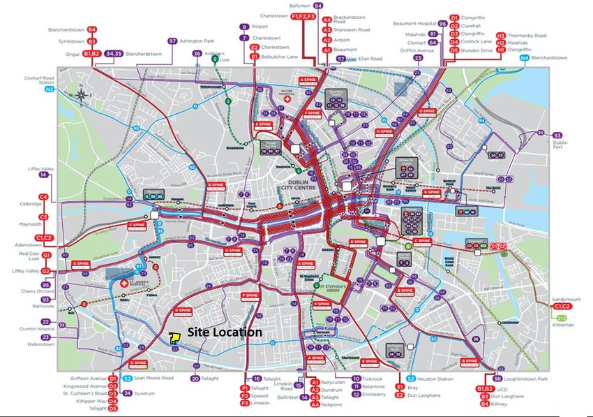
1.3 Mobility Management Plan Approach
1.3.1 This Residential Mobility Management Plan (MMP) has been prepared to guide the delivery
and management of a package of integrated initiatives which seek to encourage and embed
sustainable travel choices by residents from the outset of the development’s occupation.
1.3.2 A successfully implemented Residential MMP can provide reductions in car usage, particularly
influencing levels of single-occupancy car travel, with increased trips made by car-sharing,
public transport, walking and cycling; and can improve road safety and personal security for
pedestrians and cyclists.
1.3.3 Mobility Management is about improving the development site’s access from the outset – by
designing for and enabling and promoting sustainable travel options (e.g. walking, car-
sharing, cycling and public transport) to residents – and by reducing the need to travel by car
from the development in order to access essential services and amenities. MMPs can also
improve the health and wellbeing of residents through the benefits of active travel and reduce
the transport-related carbon impact of the development. An MMP specifically focuses on
journeys made from a single origin (home) to multiple destinations.
1.4 Report Structure
1.4.1 This report sets out the background, context and objectives of the plan, and describes a
package of measures to promote and provide for the use of sustainable modes as an
alternative to single occupancy car use to the development. A strategy for implementation,
target setting and monitoring is also discussed. The report is set out in the following structure:
Chapter 1: Report introduction
Chapter 2: An introduction to Mobility Management
Chapter 3: Proposed development
Chapter 4: Policy context
Chapter 5: Baseline site transport review
Chapter 6: Pre–occupation baseline mode share
Chapter 7: MMP objectives and targets
Chapter 8: MMP measures
Chapter 9: Monitoring and review
Chapter 10: Summary
Mobility Management Plan
Proposed Strategic Housing Development, Former Bailey Gibson Site, 326-328 South Circular Road, Dublin 8 Page 7/56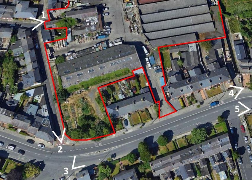
2. MOBILITY MANAGEMENT: CONTEXT
2.1 What is Mobility Management?
2.1.1 Mobility Management is a concept to promote sustainable transport and manage the demand
for car use by changing travellers’ attitudes and behaviour. Mobility Management is about
improving a site’s access, by designing for and enabling and promoting sustainable travel
options (e.g. walking, cycling and public transport) to residents. The use of Mobility
Management is well established in Ireland through the Development Control process and the
policy documents set out in Chapter 3. The process involves key stakeholders such as the
Local Authority, public transport operators, the developer and future residents.
2.2 The Benefits of Mobility Management
2.2.1 Implementing a Mobility Management Plan (or Travel Plan) has the following potential local
benefits:
Promoting alternative uses to the car can result in less congestion and therefore
improves safety on local roads by promoting alternatives to the car.
Reduced highway capacity problems can enable more sustainable travel choices.
The local environment will be improved from reduced congestion, carbon
emissions, pollution and noise.
A range of travel options makes the development site attractive to potential
residents.
Increases opportunities for active healthy travel, such as walking and cycling.
Reduces demand for parking spaces, enabling land to be put to more cost-effective
or commercially beneficial use and freeing space for active travel initiatives.
Improved travel choice, quality and affordable access to services for all users.
2.3 Mobility Management Plan Objectives
2.3.1 The overarching objectives of the MMP are to reduce levels of private car use by encouraging
people to walk, cycle, use public transport, car share. It can also reduce the number and
length of trips undertaken / required (for example through the promotion of internet
shopping and home working, and the provision of an on-site parcel delivery services).
2.3.2 The specific objective(s) of an MMP can vary depending upon the organisation, site
characteristics and specific land uses which vary with each site. Nevertheless, in the context
of a residential MMP, objectives can include:
Residents
Address residents’ need for sustainable access to a full range of facilities for work,
education, health, leisure, recreation and shopping.
Promote healthy lifestyles and sustainable, vibrant local communities by improving
the environment and the routes available for cycling and walking.
The Local Community
Make local streets less dangerous, less noisy and less polluted and enhance the
viability of public transport
Mobility Management Plan
Proposed Strategic Housing Development, Former Bailey Gibson Site, 326-328 South Circular Road, Dublin 8 Page 8/56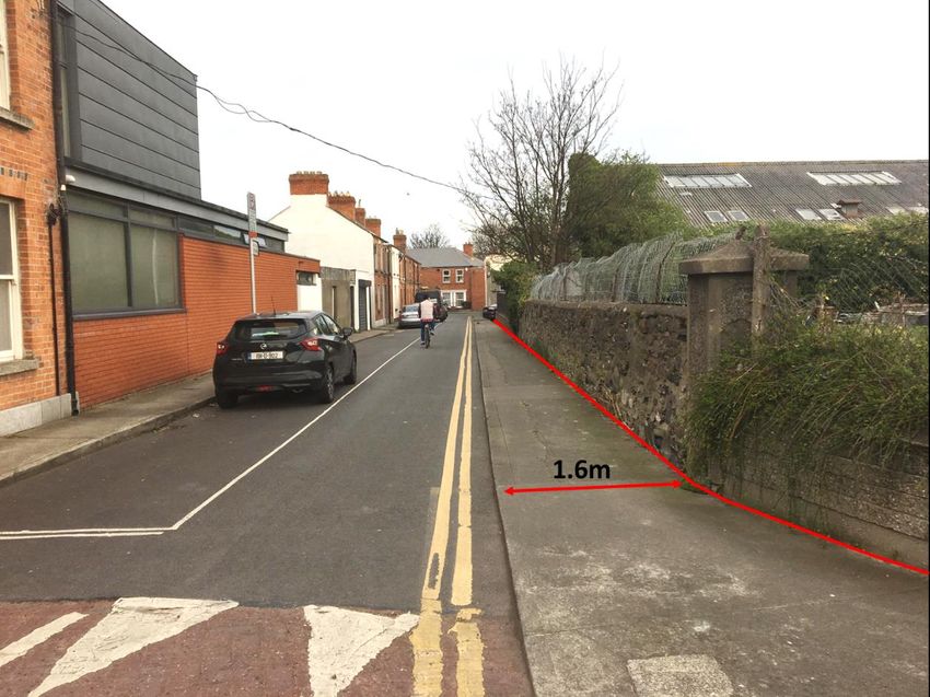
Reduce the traffic generated by the development for journeys both within the
development and on the external road network
Promote equal opportunities by offering wider travel choices
Improve personal and wider community health
Reduce air and noise pollution.
2.4 Making Residential Mobility Management Plans Work
2.4.1 A successful RMMP will address all aspects of a development that create a need to travel by
site residents. The RMMP ‘pyramid’ below demonstrates how successful plans are built on
the firm foundations of location and site design. A RMMP should combine hard measures
(e.g. cycle parking, routes to bus stops) and soft measures (such as bus taster tickets and
personalised journey planning). All measures should be integrated into the design, marketing
and occupation of the site – with parking restraint often crucial to the success of the MMP in
reducing car use.1
Figure 2.1 The Travel Plan Pyramid
2.4.2 MMPs are evolutionary documents that should be regularly updated. In this way, MMP
targets and Action Plans can be reviewed and tailored to take account of ongoing changes in
travel patterns. It is therefore intended that this MMP is the starting point of a live process
and will be updated on an annual basis or when required by other circumstances. MMP
specific objectives should be ‘SMART’ (Specific, Measurable, Achievable, Realistic and Time-
Bound).
1
UK Department for Transport Making Residential Travel Plans Work – June 2007
Mobility Management Plan
Proposed Strategic Housing Development, Former Bailey Gibson Site, 326-328 South Circular Road, Dublin 8 Page 9/56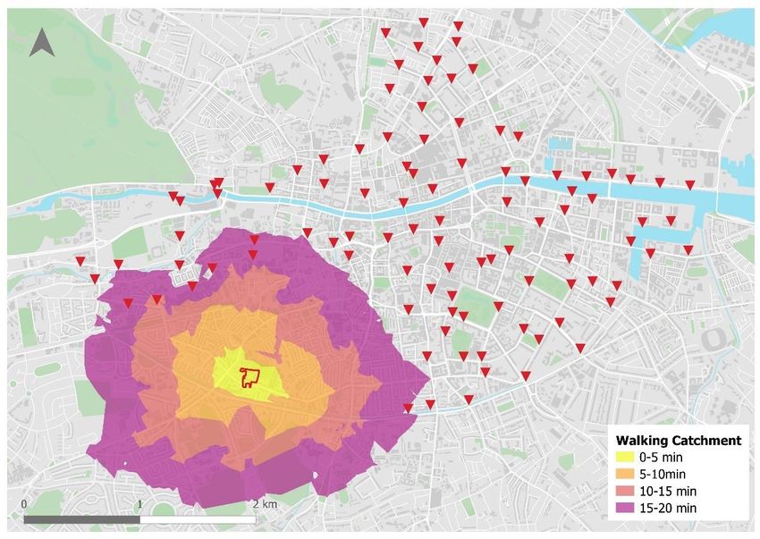
3. THE POLICY AND PLAN CONTEXT
3.1 Policy and Plan Overview
3.1.1 This section provides an overview of the national, regional and local transport and other policy
drivers and strategies that underpin the requirements (and benefits) of implementing a
Residential Mobility Management Plan for the proposed residential development. Please also
see the accompanying Transport Assessment for a more detailed overview of current
transport policy, plans and strategies of relevance to the site.
3.2 National Policy Context
3.2.1 This section provides an overview of the main national policy drivers and strategies that
underpin the requirements (and benefits) of implementing a Residential MMP for the
residential development proposed at the Bailey Gibson site.
Ireland 2040 Our Plan – National Planning Framework
3.2.2 The Project Ireland 2040 - National Planning Framework (NPF) recognises that
improvements in connectivity are achievable and are necessary to boost both
competitiveness and quality of life. The Ireland 2040 Vision includes the following key
elements which have direct relevance to Mobility Management.
1. More sustainable choices and options for people, businesses and communities
that can positively influence sustainable patterns of living and working.
2. The highest possible quality of life for our people and communities, underpinned
by high quality, well managed built and natural environments.
3. Significant improvement in local and international connectivity that underpins the
competitiveness and quality of life of our people, businesses, communities and
regions.
3.2.3 The NPF has been developed to deliver the following National Strategic Outcomes (as part of
the Smart Growth Urban Initiative to achieve sustainable growth) which are pertinent to this
report. These are to:
Improve accessibility to and between centres of mass and scale and provide better
integration with their surrounding areas.
Ensure transition to more sustainable modes of travel (walking, cycling, public
transport) and energy consumption (efficiency, renewables) within an urban
context.
3.2.4 The NPF seeks to enable people to live closer to where they work, moving away from the
current unsustainable trends of increased commuting. It supports more energy efficient
development through the location of housing and employment along public transport
corridors, where people can choose to use less energy intensive public transport, rather than
being dependent on the car.
3.2.5 The Eastern and Midland Regional Assembly (EMRA), through its “Regional Spatial and
Economic Strategy”, also supports travel planning. Specifically, through Regional Policy
Objective (RPO) 8.7 which promotes the use of mobility management and travel plans to bring
about behaviour change and more sustainable transport use.
Mobility Management Plan
Proposed Strategic Housing Development, Former Bailey Gibson Site, 326-328 South Circular Road, Dublin 8 Page 10/56Smarter Travel, A Sustainable Transport Future (STASTF) – A New Transport Policy for Ireland, 2009
– 2020
3.2.6 As recognised in Smarter Travel, A Sustainable Transport Future – A New Transport Policy for
Ireland 2009 – 2020 there is a need to provide an integrated transport network that enables
the efficient, effective and sustainable movement of people and goods, in order to contribute
to economic, social and cultural progress.
3.2.7 This policy recognises that without intervention, congestion will get worse, transport
emissions will continue to grow, economic competitiveness will suffer, and quality of life will
decline. The key goals are as follows:
Improve quality of life and accessibility to transport for all and for people with
reduced mobility and those who may experience isolation due to lack of transport.
Improve economic competitiveness through maximising the efficiency of the
transport system and alleviating congestion and infrastructural bottlenecks.
Minimise the negative impacts of transport on the local and global environment
through reducing localised air pollutants and greenhouse gas emissions.
Reduce overall travel demand and commuting distances travelled by the private
car.
Improve security of energy supply by reducing dependency on imported fossil fuels.
3.2.8 The implementation of STASTF will also assist in meeting Ireland's international obligations
towards tackling climate change. The following actions are relevant to the proposed
residential development at the Bailey Gibson site:
3.2.9 Action 1 – We will continue to enhance existing legislative provisions to deliver deeper
integration of travel and spatial planning and to support the full integration and alignment of
transport plans with the development plan process and local area planning (see also Action
42).
3.2.10 Action 2 – We will ensure better integration of land use planning and transport policies in the
relevant planning guidelines as part of their ongoing review and we will avail of policy
directives to give effect to specific measures needed to meet the vision for sustainable travel.
The following will also be included in future planning guidelines: a requirement that
developments above a certain scale have viable travel plans in place. The following will also
be included in future planning guidelines:
A general requirement that significant housing development in all cities and towns
must have good public transport connections and safe routes for walking and
cycling to access such connections and local amenities.
Integration of cycling and public transport.
A requirement that developments above a certain scale have viable travel plans in
place
National Cycle Policy Framework, 2009-2020
3.2.11 The National Cycle Planning Policy Framework 2009-2020 (NCPF) aims to create a new culture
of cycling in Ireland, with a target of 10% of all trips to work being made by bike by 2020.
Mobility Management Plan
Proposed Strategic Housing Development, Former Bailey Gibson Site, 326-328 South Circular Road, Dublin 8 Page 11/56The National Cycle Manual
3.2.12 The National Cycling Manual is focused on encouraging more people to cycle and providing
for cycling in a stress free and safe environment. The Manual embraces the Principles of
Sustainable Safety to offer a safe traffic environment for all road users including cyclists and
offers guidance on integrating the bike in the design of urban areas. It challenges planners
and engineers to incorporate cycling within transport networks more proactively than before.
Get Ireland Active – The National Physical Activity Plan, 2016
3.2.13 Another key policy driver for the encouragement of active, healthy commuting trips is the Get
Ireland Active – National Physical Activity Plan (NPAP). Launched in 2016, this plan
recognises that physical inactivity is a demonstrated clear risk to health and wellbeing in
Ireland.
3.2.14 The NPAP is about creating increased opportunities for people to be active in ways which fit
in to their everyday lives and which suits individual needs, circumstances and interests, and
to remove the barriers which people face to being active – by encouraging a supportive
environment where physical activity becomes normal.
3.2.15 The NPAP focuses on the use of the natural and built environment. It recognises that
promoting active transport are the most practical and sustainable ways to increase physical
activity as part of people’s everyday routine. It specifically identifies the role of walking or
cycling for utility transport as a means to increase people’s physical activity levels.
3.3 Regional and Local Policy Context
3.3.1 This section provides an overview of the main regional and local policy drivers and strategies
that underpin the context, requirements and benefits of a Mobility Management Plan for the
proposed residential development.
Greater Dublin Area Transport Strategy, 2016-2023
3.3.2 This strategy aims to contribute to the economic, social and cultural progress of the Greater
Dublin Area by providing for the efficient, effective and sustainable movement of people and
goods – helping to reduce modal share of car-based commuting to a maximum of 45%. To
achieve these principles, future developments must:
Have transport as a key consideration in land use planning – integration of land use
and transport to reduce the need to travel, reduce the distance travelled, reduce
the time taken to travel, promote walking and cycling especially within
development plans.
Protect the capacity of the strategic road network.
Ensure a significant reduction in share of trips taken by car, especially those trips
which are shorter or commuter trips.
Take into account all day travel demand from all groups.
Provide alternate transport modes in order to reduce the strain on the M50 as
current increase in traffic is unsustainable.
3.3.3 The site is within walking distance of improved public transport provisions such as the
proposed BusConnects Core Bus Corridor(s), which will enhance the overall public transport
Mobility Management Plan
Proposed Strategic Housing Development, Former Bailey Gibson Site, 326-328 South Circular Road, Dublin 8 Page 12/56provision across urban Dublin. This will improve public transport options for residents,
including for those commuting to destinations across the wider Dublin area.
Greater Dublin Area Cycle Network Plan, 2013
3.3.4 The Greater Dublin Area Cycle Network Plan sets out a 10-year strategy to expand the urban
cycle network from 500km to 2,480km. The overarching ambition of the scheme is to, by
2021, increase the number of commuters who commute by bike to be the same amount as
those who commute by bus.
3.3.5 The network will consist of a series of primary, secondary and feeder routes as well as
greenways routes. These routes will comprise of a mix of cycle tracks and lanes, cycleways
and infrastructure-free cycle routes in low traffic environments.
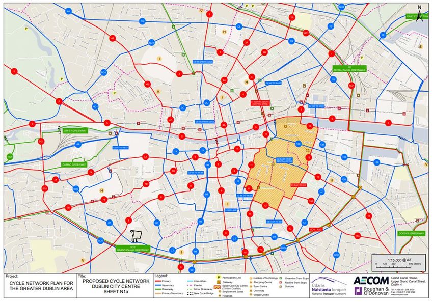
3.3.6 The proposed cycle network surrounding the development is shown below, with the Grand
Canal Greenway, the Primary Routes 8 and SO1 / N10 and the Secondary Routes C7 and 8C
all adjacent or close to the subject site.
Figure 3.1 GDA South Dublin Cycle Network Plan
BusConnects
3.3.7 BusConnects is part of the overall GDA Transport Strategy and aims to overhaul the current
bus system in the Dublin region through a number of measures, as outlined below. The
measures will improve public transport access and reliability for future residents of the
proposed development. The BusConnects programme includes:
Building a network of “next generation” bus corridors on the busiest bus routes to make
bus journeys faster, predictable and reliable.
Mobility Management Plan
Proposed Strategic Housing Development, Former Bailey Gibson Site, 326-328 South Circular Road, Dublin 8 Page 13/56 Introducing Bus Rapid Transit, a higher quality of bus system, on three of the busiest
corridors.
Completely redesigning the network of bus routes to provide a more efficient network,
connecting more places and carrying more passengers.
Developing a state-of-the-art ticketing system using credit and debit cards or mobile
phones to link with payment accounts and making payment much more convenient.
Implementing a cashless payment system to vastly speed up passenger boarding times.
Revamping the fare system to provide a simpler fare structure, allowing seamless
movement between different transport services without financial penalty.
Implementing a new bus livery providing a modern look and feel to the new bus system.
Rolling out new bus stops with better signage and information and increasing the
provision of additional bus shelters.
Transitioning to a new bus fleet using low-emission vehicle technologies.
3.3.8 The BusConnects programme will improve access to bus services close to the proposed
development. As illustrated below, the subject site is located close to Spine D which is defined
as very high frequency spine with proposed frequencies of 2.7-3.7 minutes based on latest
revision of the network. Line O also run directly in front of the site providing an orbital route
around the city at a frequency of 5-10 minutes.
Figure 3.2 Proposed BusConnects Service Redesign Dublin City Centre
Mobility Management Plan
Proposed Strategic Housing Development, Former Bailey Gibson Site, 326-328 South Circular Road, Dublin 8 Page 14/563.3.9 It should be noted that the network above is part of an ongoing public consultation with the
final network redesign expected in the coming months subject after the second round of
public consultation in November 2019.
3.3.10 In addition to the redesign of the bus network, a number of high frequency Core Bus Corridors
(CBCs) are proposed as part of BusConnects. The aim of CBCs is to provide segregated bus
lane priority to reduce congestion, improve bus capacity, reliability and punctuality while
reducing bus journey times along 16 of the busiest bus corridors in Dublin. CBC will run along
Dolphin’s Barn Street/Cork Street within walking distance of the subject site.
3.3.11 In addition, the CBCs will include dedicated cycle tracks on each side of the road, providing
safe cycling facilities, segregated from other vehicular traffic, with adequate footpaths for
pedestrians and supporting elements such as pedestrian crossings at all key road crossing
points and bus shelters for waiting passengers.
Dublin City Council Development Plan, 2016-2022
3.3.12 The Dublin City Development Plan provides a coherent, integrated framework to ensure the
city develops in an inclusive and sustainable manner which is resilient on social, economic and
environmental fronts in the short and longer term. The plan emphasises the need for Dublin
to become a low-carbon city and the role of compact, self-sustaining communities and
neighbourhoods, urban form and movement has to play in achieving this goal.
3.3.13 The plan details a Core Strategy which includes housing, settlement, employment, retail and
public transport strategies. The strategy translates into 3 broad strands which form the basis
for the policies and objectives outlined in the plan, these are:
Compact, Quality, Green, Connected City;
A Prosperous, Enterprising, Creative City; and
Creating Sustainable Neighbourhoods and Communities.
3.3.14 The policies and objectives of the plan are categorised into 12 broad areas. Table 3.1 below
provides a summary of the policies most relevant to this MMP.
Table 3.1 Extracts from most relevant Dublin City Development Plan 2016-2022 Policies
No. Details
“To promote the development of a network of active, attractive and safe streets and public
spaces….which encourage walking as the preferred means of movement between buildings and
SC19
activities in the city. In the case of pedestrian movement within major developments, the creation
of a public street is preferable to an enclosed arcade or other passageway.”
“To promote the development of high-quality streets and public spaces which are accessible and
SC20 inclusive, and which deliver vibrant, attractive, accessible and safe spaces and meet the needs of the
city’s diverse communities. “
“To support the creation of a permeable, connected and well-linked city and discourage gated
QH10
residential developments as they exclude and divide established communities.”
“Whilst having regard to the necessity for private car usage..to continue to promote modal shift from
MT2 private car use towards increased use of more sustainable forms of transport such as cycling, walking
and public transport...”
“To improve the city’s environment for walking and cycling through the implementation of
MT7 improvements to thoroughfares and junctions and also through the development of new and safe
route..”
“To provide 30kph speed limits and traffic calmed areas at appropriate locations throughout the city
MT10
subject to stakeholder consultation.”
“To continue to promote improved permeability for both cyclists and pedestrians in existing urban
MT11
areas...”
Mobility Management Plan
Proposed Strategic Housing Development, Former Bailey Gibson Site, 326-328 South Circular Road, Dublin 8 Page 15/56“To improve the pedestrian environment and promote the development of a network of pedestrian
MT12 routes which link residential areas with recreational, educational and employment destinations to
create a pedestrian environment that is safe and accessible to all.”
“To promote bets practice mobility management and travel planning to balance car use to capacity
MT13
and provide necessary mobility via sustainable transport modes.”
“To provide sustainable levels of car parking and storage in residential schemes in accordance with
MT17 development plan car parking standards so as to promote city centre living and reduce the
requirement for car parking.”
“To encourage new ways of addressing the paring needs of residents (such as car clubs) to reduce
MT18
the requirement for car parking.”
“To support the growth of Electric Vehicles and e-bikes, with support facilities as an alternative to
MTO25 the use of fossil-fuel-burning vehicles, through a roll-out of additional electric charging points in
collaboration with relevant agencies at appropriate locations.“
3.3.15 In terms of land use zoning part of the site forms part of SDRA 12, as discussed in Section 1.1,
which is intended for primarily residential development. The development plan outlines the
guiding principles for SDRA 12, the principles relevant to this transport assessment are as
follows;
“The development of a network of streets and public spaces will be promoted to
ensure the physical, social and economic integration of St. Teresa’s Gardens with
the former Player Wills & Bailey Gibson site, with further integration potential with
the site of the Coombe Hospital and White Heather Industrial Estate. “
“Strong permeability through these lands will be encouraged to generate
movement and activity east-to-west (connecting Dolphin’s Barn Street and Cork
Street with Donore Avenue) and north-to-south (connecting Cork Street and Donore
Avenue with the South Circular Road and Grand Canal Corridor); a high-quality
public domain, provision of pedestrian and cyclist routes and provision of actives
streets will be promoted.”
3.3.16 Section 16.38 & 16.39 set out the car and cycle parking standards respectively. The plan states
that car parking standards are maximum in nature and may be reduced where other modes
of transport provide sufficient mobility for residents. Alternative solutions will also be
considered such as residential car clubs where there are site constraints.
Development Framework for St. Teresa’s Gardens & Environs
3.3.17 In 2017, DCC prepared a framework plan for SDRA 12 to translate the guiding principles,
outlined previously, for the site identified in the Dublin City Development Plan. This plan
covered the DCC lands, the Player Wills site and part of the Bailey Gibson site. The plan
included an internal road layout and street hierarchy which prioritised the integration of the
three sites and strong permeability to generate movement east-west and north-south
through the site. All roads within the sites were proposed to be 15m wide building to building.
A detailed transport assessment was not undertaken as part of the original development
framework. The proposed road layout and street hierarchy is shown in Figure 3.3. There is no
indication within the development framework if all access points were to allow for vehicular
movements.
Mobility Management Plan
Proposed Strategic Housing Development, Former Bailey Gibson Site, 326-328 South Circular Road, Dublin 8 Page 16/56Figure 3.3 SDRA 12 Development Framework – Proposed Road Layout and Street Hierarchy
SDRA 12 – Masterplan for Player Wills, Dublin City Council & Bailey Gibson Lands
3.3.18 A more detailed masterplan was developed by DCC to expand on the work previously
undertaken as part of the development framework and to reflect the changes in national
planning policy since the publication of the original framework plan. The masterplan was
developed to demonstrate how the three sites, including Bailey Gibson in its entirety, could
be developed in an integrated manner that delivers on the objectives of the SDRA
development framework and the guiding principles set out in the DCC development as
discussed in Section 3.3.15.
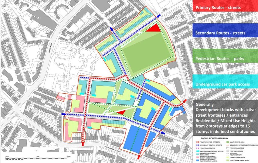
3.3.19 The masterplan includes an updated access strategy, road layout and street hierarchy which
is similar to what was proposed in the development framework plan but reflects the
opportunity and constraints of each site, the feasibility of access for each mode and access
points not previously considered. The primary routes through the site were also increased
from 15m to 18m to allow increased space to widen footpaths, landscaping and on-street car
and cycle parking. Figure 2.2 shows the masterplan access strategy in full.
Mobility Management Plan
Proposed Strategic Housing Development, Former Bailey Gibson Site, 326-328 South Circular Road, Dublin 8 Page 17/56Figure 3.4 Masterplan – Proposed Road Layout and Access Strategy
3.3.20 The masterplan also outlines a high-level parking strategy which details a reduced level of car
parking for the site based on the masterplan lands accessibility and proximity to public
transport. However, the plan also states that some level of parking will be needed to meet
parking requirements on site to promote city centre and family living and prevent illegal
parking on street. The masterplan also states that a Mobility Management Plan will be
required to be implemented for each of the sites with a number of examples of ‘hard’ and
‘soft’ measures given to encourage sustainable travel to/from the site. These includes car-
sharing, increased cycle parking, on site facilities and appointment of a Mobility Manager
amongst others.
Mobility Management Plan
Proposed Strategic Housing Development, Former Bailey Gibson Site, 326-328 South Circular Road, Dublin 8 Page 18/564. THE PROPOSED DEVELOPMENT
4.1 Overview
4.1.1 The proposed development will be split across 5 blocks ranging in height from 2 to 16 floors.
The location of the blocks is shown in Figure 4.1 below.
Figure 4.1 Block Layout Plan
4.1.2 The development will consist of;
the demolition of all buildings and structures on the site, including 9 no. buildings (11,234.42
sq.m GFA) and 1 no. ESB substation (21sq.m) to make way for development of the site;
the construction of 416 no. residential units in 5 no. blocks, with a cumulative gross floor area
of 31,117 sq.m for the residential component comprising;
o 404 no. apartments in 4 no. blocks (BG1-4) ranging in height from 2 storeys to 16
storeys, over single level basement on part of the site, incorporating 19 no. studio
units; 251 no. 1 bed and 134 no. 2 bed, all with private amenity space in the form of
balconies;
Mobility Management Plan
Proposed Strategic Housing Development, Former Bailey Gibson Site, 326-328 South Circular Road, Dublin 8 Page 19/56o 2 no. 2-storey 2-bedroom duplex apartments all with private amenity space in the
form of balconies contained in BG3.
o 6 no. 3-storey 3-bedroom triplex apartments all with private amenity space in the form
of terraces contained in BG1;
o 4 no. 3-storey 4-bedroom townhouses all with private amenity space in the form of
back gardens and 4 no. car parking spaces contained in BG5;
the construction of tenant amenities with a cumulative gross floor area of 812 sq.m
comprising; in BG1, a concierge office (86 sq.m at ground floor level); in BG2, gymnasium (260
sq.m), combined concierge/marketing/coworking space (191 sq.m) at ground floor and
communal living/ kitchen (166 sq.m) and residents lounge (29 sq.m) at first floor level; and in
BG3, a resident’s lounge (24 sq.m) that connects with the communal garden.
provision of 2,618 sq.m of communal open space distributed as follows; in BG1, central
courtyard area (774 sq.m) and roof terrace (60 sq.m); in BG2, roof terrace (926 sq.m); in BG3,
courtyard (545 sq.m); and in BG4, courtyard (313 sq.m).
the construction of a childcare facility with a gross floor area of 233 sq.m and associated play
areas of 50 sq.m and 3 no. set-down parking spaces;
the construction of 164 sq.m of commercial floorspace to facilitate a restaurant/café/bar at
ground level in Block BG2 and 224 sq.m of commercial floorspace at ground floor level in Block
BG1 to facilitate a range of uses including Class 1 (shop), Class 2 (financial/professional
services) , Class 8 (health services), Class 10 (community/arts) and Class 11 (bingo hall);
the construction of a single storey ESB sub-station (14 sq.m GFA) and a double ESB sub-station
(28 sq.m GFA);
partial realignment and widening of Rehoboth Place to provide a new carriageway width of
5m, enabling fire tender and refuse truck access, and minimum footpath widths of 2m on both
sides of the street.
at basement level, the provision of 106 no. car parking spaces including 10 no. dedicated
disabled parking spaces. 10% of the spaces will be fitted with electric charging points. 12 no.
motorcycle spaces will also be provided at basement level.
at podium level, the provision of 12 no. car parking spaces, including 1 no. disabled parking
space (10 no. reserved for car sharing scheme ‘Go Car’) and 15 no. on street visitor car parking
spaces (4 no. of which will be reserved for ‘Go Cars’), including 1 no. dedicated disabled parking
space, together with 3 no. set down parking spaces for taxis and crèche drop offs and a loading
bay to service the commercial units.
the provision of 543 no. long-stay bicycle parking spaces, comprising 315 no. spaces at
basement level, accessed via a dedicated cycle stairway, and 228 no. spaces at surface level.
84 no. short stay visitor cycle spaces are provided at surface level.
vehicular access will be via Rehoboth Place and vehicular exit will be via the existing access on
South Circular Road. Provision of 3 no. pedestrian access points; 1 no. from the South Circular
Road; 1 no. from Rehoboth Place; and 1 no. from Rehoboth Avenue. Improvement works to
the existing entrance on South Circular Road, removal of existing uncontrolled pedestrian
crossing and provision of a new signalised pedestrian crossing is proposed on South Circular
Road to facilitate improved access for existing and future residents of the area to bus stops
along with improvement to the footpath provision along South Circular Road opposite
Rehoboth Place entry.
Mobility Management Plan
Proposed Strategic Housing Development, Former Bailey Gibson Site, 326-328 South Circular Road, Dublin 8 Page 20/56 all ancillary site development works, plant, waste storage, meter rooms, rooftop solar
photovoltaics, landscaping, boundary treatment and lighting.
4.2 Internal Pedestrian and Cyclist Provision
4.2.1 The Design Manual for Urban Roads & Streets (DMURS) indicate a hierarchy of travel modes
with walking being the highest and most sustainable form of travel. Walking will not reduce
long distance trips, however encouraging walking will reduce short distance vehicle trips,
provide linkage to public transport and as an added benefit, will improve health and fitness.
4.2.2 There is a well-established network of footways throughout the surrounding area that provide
strong connections between the proposed development and key local facilities / amenities.
This is discussed further in Section 5.3.
4.2.3 The internal network of the proposed development has been designed to prioritise
sustainable transport modes, while allowing for required vehicular access to car parking and
for service vehicles. Not only will it seek to provide a safe and permeable environment for
residents of the proposed development, it will also aim to provide a safe and direct link
between the site and the external pedestrian and cycling networks and a future link to the
full masterplan area.
4.2.4 As the layout in Figure 4.2 demonstrates, pedestrian access will be provided from multiple
access points along the South Circular Road, Rehoboth Place & Avenue. The access point to
the west onto Rehoboth Place will be pedestrian and cyclist only. Cyclists will be able to utilise
the vehicle and pedestrian accesses.
Figure 4.2 Pedestrian Access
Mobility Management Plan
Proposed Strategic Housing Development, Former Bailey Gibson Site, 326-328 South Circular Road, Dublin 8 Page 21/564.2.5 Cycling Access follows the one-way system for vehicular traffic off the South Circular Road
with additional accesses provided onto Rehoboth Place. There are shared pedestrian/cycle
paths around the perimeter which also provide access to some of the long stay cycle parking.
The cycle access of shown on Figure 4.3.
Figure 4.3 Cycle Access
4.2.6 The access strategy outlined is part of the wider access strategy planned for the full SDRA 12.
The SDRA access strategy is shown in Figure 4.4. As shown, there is a planned shared surface
street running east-west through the three sites south of the proposed neighbourhood park.
This will connect the pedestrian only access points onto St. Catherine’s Avenue and Rehoboth
Place creating a strong walking connection through the site.
Mobility Management Plan
Proposed Strategic Housing Development, Former Bailey Gibson Site, 326-328 South Circular Road, Dublin 8 Page 22/56Figure 4.4 SDRA 12 Masterplan Access Strategy
4.3 Cycle Parking
4.3.1 Long stay cycle parking is provided separately for each of the four residential blocks and is
provided at a ratio of 1.3 bike spaces per unit, above the DCC standard of 1 per unit. There
will also be spaces provided for staff on site. The long-stay parking will be two tier stacked
parking and secured in indoor bike rooms accessible by residents only. The type of model
proposed for the cycle parking is shown below in Figure 4.3.
Mobility Management Plan
Proposed Strategic Housing Development, Former Bailey Gibson Site, 326-328 South Circular Road, Dublin 8 Page 23/56Figure 4.5 Two-Tier Bike Model
4.3.2 The model above has a gas assisted lifting mechanism for ease of use and bikes can be
securely chained to the rack. The bike rooms provided as part of the development have all be
designed to ensure adequate floor to ceiling height (3-3.7m) and aisle width to accommodate
the two-tier parking (minimum 2.4m). The dimensions of the model above are shown in Figure
4.5.
Figure 4.6 Two-Tier Bike Model Dimensions
4.3.3 In addition to the long stay parking there will be on-street visitor parking provided at locations
throughout the development. In total 84 visitor cycle spaces will be provided at the 4 locations
shown in Figure 4.6.
Mobility Management Plan
Proposed Strategic Housing Development, Former Bailey Gibson Site, 326-328 South Circular Road, Dublin 8 Page 24/56Figure 4.7 On-street Visitor Cycle Parking
4.4 Cycle Hire
4.4.1 There are limited Dublin Bike stations within walking distance of the site with the nearest sites
approximately 15 minutes’ walk. Currently there are no plans to expand the Dublin Bikes
Scheme with any future stations dependent on the availability of additional funding for capital
and operational costs. There are several designated bleeper bike parking spaces close to the
site along Dolphin’s Barn Street, see Section 5.4.5. Any suitable parking stand can be added
as a designated space by a user sending the location and photographs to the BleeperBike
support team.
4.5 Vehicular Access
4.5.1 The proposed vehicular access strategy is illustrated in Figure 4.7. This has been developed
based on the site constraints discussed in Section 5.5 of the TTA. As shown, access will be
limited to a one-way entrance via South Circular Road/Rehoboth Place and one-way exit
through the existing entrance directly onto the South Circular Road. Both junctions off the
South Circular Road will be priority junctions. The road network will ultimately link to the DCC
lands north and south of the development which will provide further accesses to Donore
Avenue. A secondary access will be provided to the north of Rehoboth Avenue; however, this
will provide access to just 4 houses and accompanying parking spaces.
Mobility Management Plan
Proposed Strategic Housing Development, Former Bailey Gibson Site, 326-328 South Circular Road, Dublin 8 Page 25/56Figure 4.8 Vehicular Access Strategy
4.5.2 Rehoboth Place will be widened to the primary development entry point to accommodate
the additional traffic generated by the proposed one-way entry point. Though access to the
development will be one-way, two-way traffic flow will be maintained on the external
network for the convenience of existing residents. Future residents of the site will be
prevented from exiting through Rehoboth Place as the road linking to it will be one-way
inbound.
4.6 Car Parking
4.6.1 Long stay car parking will be provided at a rate of 0.29 spaces per unit, 122 spaces in total.
The majority of long stay spaces, 106 spaces, will be at basement level with 12 spaces
provided in podium level car park and 4 further spaces provided at BG5 and assigned to the
townhouses within BG 5. The spaces provided at podium level will be used for car sharing
with 10 GoCars provided upon development opening, this is discussed further in Section 8.10.
4.6.2 A total of 9% of spaces will be disability parking, over the 5% minimum in the DCC
development plan, and a further 12 motorcycles spaces will be provided at basement level in
Mobility Management Plan
Proposed Strategic Housing Development, Former Bailey Gibson Site, 326-328 South Circular Road, Dublin 8 Page 26/56addition to the car spaces. Electric charging points will also be installed for 10% of spaces
initially with the remainder future proofed for 100% installation.
4.6.3 An additional 15 car spaces (incl. one disability space) will be provided on street to ensure
adequate parking is provided for visitors and negate any overspill onto the surrounding street.
The total number of visitor spaces has been maximised whilst maintaining a quality public
realm. This parking will be paid ‘pay and display’ car parking. 4 of the on-street spaces will be
reserved for Go-Cars which will available for use by any registered GoCar member.
4.6.4 Also included on street is a loading bay for drop offs to the concierge office and deliveries to
the proposed retail, three set down spaces for the creche and taxis.
4.7 Services and facilities to reduce the need to travel
4.7.1 As mentioned there will be tenant amenities included on site to help reduce the need to travel
outside of the site. These tenant amenity facilities incorporating a gymnasium, business
centre, entertainment areas and a concierge office. There is retail/food & beverage area
planned on the ground floor also. When the masterplan is delivered in full the residents will
also have access to additional retail on the DCC and Player Wills sites, the neighbourhood park
and municipal playing pitch.
Mobility Management Plan
Proposed Strategic Housing Development, Former Bailey Gibson Site, 326-328 South Circular Road, Dublin 8 Page 27/565. BASELINE REVIEW: EXISTING TRANSPORT NETWORK
5.1 Overview
5.1.1 The following chapter discusses the existing transport network surrounding the site. A
detailed commentary is provided on the existing walking, cycling and public transport facilities
near the site.
5.2 The Site
5.2.1 The site is located on the South Circular Road and borders Rehoboth Place. It sits east of
Dolphin’s Barn and south-west of Donore Avenue. The primary access point to the site is
currently located along the South Circular Road with an unused secondary access onto
Rehoboth Place. The location of the site in relation to the surrounding road network is shown
in Figure 5.1 below.
Figure 5.1 Site Location & Surrounding Road Network
5.3 Walking Accessibility & Infrastructure
5.3.1 The site is within a convenient walking distance of the city centre and a number of large
employment centres as well as leisure and retail facilities. The Coombe Maternity Hospital is
located within less than 5-minute walk of the site. St. James's Hospital, home to the future
national children’s hospital, is within 15-minute walk of the site as is Griffith College and the
Guinness Storehouse. The city centre is a 25-30-minute walk. Heuston Station, the Phoenix
Park and the Royal Hospital Kilmainham are also within a 30-minute walk of the site. Figure
5.2 below outlines the walking catchment in 5-minute intervals.
Mobility Management Plan
Proposed Strategic Housing Development, Former Bailey Gibson Site, 326-328 South Circular Road, Dublin 8 Page 28/56Figure 5.2 Walking Catchment Mobility Management Plan Proposed Strategic Housing Development, Former Bailey Gibson Site, 326-328 South Circular Road, Dublin 8 Page 29/56
5.3.2     In total, there are over 72,000 estimated jobs within the total catchment area shown. Table
          5.1 outlines the cumulative number of jobs accessible within each 5-minute interval.
          Table 5.1 Jobs Accessible by Walking
                               Time Travelled                                               Jobs Accessible
                                    0-5 min                                                        921
                                   0-10 min                                                       3,220
                                   0-15 min                                                       8,264
                                   0-20 min                                                      18,555
                                   0-25 min                                                      39,713
                                   0-30 min                                                      72,350

5.3.3     In addition to the employment centres outlined, there are many local creches, schools,
          convenience shops and supermarkets, sports and youth clubs and parks & community
          gardens within easy walking distance of the site. The local amenities and walking catchment
          are shown in Figure 5.3.
          Figure 5.3 Local Walking Catchment & Amenities

5.3.4     In the immediate vicinity of the site there are good quality pedestrian routes along South
          Circular Road with width footpaths varying between 2.2 & 4.2m between Donore Avenue and
          Dolphin’s Barn Cross and good quality lighting. There are no formal zebra or signalised
          crossing point along this stretch of the South Circular Road however there is an unmarked
          pedestrian crossing, with dropped kerb lines and traffic island directly in front of the
          development. Along Rehoboth Place the footpaths are narrower varying between 1.1-1.6m
          though this street is very lightly trafficked. Figures 5.4-5.9 capture the pedestrian
          environment on the surrounding streets.

  Mobility Management Plan
                                                                                                              Page 30/
  Proposed Strategic Housing Development, Former Bailey Gibson Site, 326-328 South Circular Road, Dublin 8
                                                                                                                   56
Figure 5.4 Pedestrian Environment - Overview
(Map Data © Google Earth Pro)
Mobility Management Plan
Proposed Strategic Housing Development, Former Bailey Gibson Site, 326-328 South Circular Road, Dublin 8 Page 31/56Figure 5.5 Pedestrian Environment – Viewpoint 1- Rehoboth Place toward Dolphin’s Barn Street
Mobility Management Plan
Page 32/
Proposed Strategic Housing Development, Former Bailey Gibson Site, 326-328 South Circular Road, Dublin 8
56Figure 5.6 Pedestrian Environment – Viewpoint 2- Rehoboth Place Northwards
Figure 5.7 Pedestrian Environment – Viewpoint 3- South Circular Road eastwards
Mobility Management Plan
Page 33/
Proposed Strategic Housing Development, Former Bailey Gibson Site, 326-328 South Circular Road, Dublin 8
56Figure 5.8 Pedestrian Environment – Viewpoint 4 – South Circular Road westwards
Figure 5.9 Pedestrian Environment – Viewpoint 5 - South Circular Road westwards
Mobility Management Plan
Page 34/
Proposed Strategic Housing Development, Former Bailey Gibson Site, 326-328 South Circular Road, Dublin 8
565.3.5 There are also signalised pedestrian crossing points at Dolphin’s Barn Cross and South Circular
Road/Donore Avenue Junction west and east of the site. Dolphin’s Barn Street & Cork Street
also have wide footpaths as does the remainder of the South Circular Road until it terminates
near Harcourt Road.
5.4 Cycling Accessibility & Infrastructure
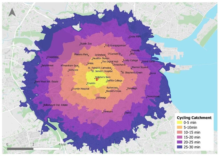
5.4.1 The site is also highly accessible by cycling. The city centre, TUD Grangegorman, St. James’s
Hospital and Heuston Station are all within a 15-minute cycle of the site. There are an
estimated 148,050 jobs within a 15-minute cycle of the site and over 340,000 within a 30-
minute cycle. Figure 5.10 outlines the cycling catchment in 5-minute intervals. The estimated
number of jobs accessible within this catchment is outlined in Table 5.2.
Table 5.2 Jobs Accessible by Cycling
Time Travelled Jobs Accessible
0-5 min 5,942
0-10 min 47,683
0-15 min 148,050
0-20 min 249,251
0-25 min 301,127
0-30 min 341,377
Mobility Management Plan
Page 35/
Proposed Strategic Housing Development, Former Bailey Gibson Site, 326-328 South Circular Road, Dublin 8
56Figure 5.10 Cycling Catchment Mobility Management Plan Proposed Strategic Housing Development, Former Bailey Gibson Site, 326-328 South Circular Road, Dublin 8 Page 36/56
5.4.2      There are cycle lanes provided most of the way from Dolphin’s Barn Cross to the City Centre
           and along the length of the Canal towards the docklands as shown from the existing facilities
           map taken from the Greater Dublin Area Cycle Strategy and illustrated in Figure 5.11. There
           are currently no cycle lanes along the South Circular Road and Donore Avenue but there is a
           bus lane eastbound along the South Circular Road and westbound on approach to Dolphin’s
           Barn Cross.
            Figure 5.11 Existing Cycle Facilities

            (Map Data © National Transport Authority2)

5.4.3      In terms of bike sharing infrastructure there are two main bike sharing schemes within Dublin,
           Dublin Bikes and BleeperBikes. Dublin Bikes is a public bike rental scheme facilitated by
           numerous stations around Dublin City primarily within the Canal Cordon. BleeperBikes is a
           station-less bike sharing scheme where users park the bike at designated parking spaces
           through the city with the scheme extending well beyond the canals into the north and south
           of the city.

5.4.4      As discussed, there are limited Dublin Bike stations within walking distance of the sites with
           the nearest sites approximately 15 minutes’ walk, as illustrated in Figure 5.12. Currently there
           are no plans to expand the Dublin Bikes Scheme with any future stations dependent on the
           availability of additional funding for capital and operational costs.

2
 GDA Cycle Network Plan- Existing Facilities Maps https://www.nationaltransport.ie/wp-
content/uploads/2014/04/Existing_Facilities_Maps11.pdf

Mobility Management Plan
                                                                                                           Page 37/
Proposed Strategic Housing Development, Former Bailey Gibson Site, 326-328 South Circular Road, Dublin 8
                                                                                                                56
Figure 5.12 Dublin Bike Stand Locations
5.4.5 There are several designated bleeper bike parking spaces close to the proposed developments
as shown in Figure 5.13. Any suitable parking stand can be added as a designated space by a
user sending the location and photographs to the BleeperBike support team.
Figure 5.13 BleeperBike Designated Parking Locations
(Map Data © Google & Bleeper Bikes)
Mobility Management Plan
Page 38/
Proposed Strategic Housing Development, Former Bailey Gibson Site, 326-328 South Circular Road, Dublin 8
565.5 Public Transport Infrastructure
5.5.1 The site is located within a 5-minute walk of a numerous high frequency Dublin Bus & Go-
Ahead services along Dolphin’s Barn Street/Cork Street, a dedicated Quality Bus Corridor, and
the South Circular Road. It is also a 9-minute walk to the Fatima Red line Luas stop. Figure
5.14 below illustrates the existing public transport network and stop locations.
Figure 5.14 Local Public Transport Services
5.5.2 All bus services shown are within a 5-minute walk of the site and operate frequently during
the weekday and weekend. Figure 5.15 shows the approximate distances to each local bus
stop from the nearest site entrance.
Figure 5.15 Distance & Path to Local Bus Stops
Mobility Management Plan
Page 39/
Proposed Strategic Housing Development, Former Bailey Gibson Site, 326-328 South Circular Road, Dublin 8
56You can also read