New Station Initial Business Case Milton-Trafalgar - Final October 2020 - Metrolinx
←
→
Page content transcription
If your browser does not render page correctly, please read the page content below
New Station Initial Business Case
Milton-Trafalgar
Final
October 2020
New Station Initial Business Case
Milton-Trafalgar
Final
October 2020
Contents

Introduction                          1

The Case for Change                   4

Investment Option                    12

Strategic Case                       18

Economic Case                        31

Financial Case                       37

Deliverability and Operations Case   41

Business Case Summary                45

iv

Executive Summary
Introduction
The Town of Milton in association with a landowner’s group (the Proponent) approached Metrolinx to assess the
opportunity to develop a new GO rail station on the south side of the Milton Corridor, west of Trafalgar Road. This
market-driven initiative assumes the proposed station would be planned and paid for by the private sector. Once
built, the station would be transferred to Metrolinx who would own and operate it. The proposed station location is
on undeveloped land, at the heart of both the Trafalgar Corridor and Agerton Employment Secondary Plan Areas
studied by the Town of Milton in 2017. As such, the project offers the Town of Milton the opportunity to realize an
attractive and vibrant transit-oriented community that has the potential to benefit the entire region.

Option for Analysis
This Initial Business Case (IBC) assesses a single option for the proposed station. The opening-day concept plan
includes one new side platform to the north of the corridor, with protection for a future second platform to the
south. The site includes 1,000 parking spots, a passenger pick-up/drop-off area (40 wait spaces, 10 load spaces),
bicycle parking (128 covered spaces, 64 secured spaces) and a bus loop including 11 sawtooth bus bays. Station
sizing is based on future transit service planning and ridership forecasting conducted using the Greater Golden
Horseshoe Model version 4 (GGHMv4) and input from Milton Transit.

Method of Analysis
The IBC utilizes the Metrolinx Business Case Guidance published in April 2019 to assess the merits of a proposed
station at this location against a Business as Usual scenario (i.e. without a new station).

As with all Metrolinx Business Cases, the IBC is structured around four cases:

•   The Strategic Case determines the value of addressing a problem or an opportunity based on local, regional,
    and provincial goals, plans and policies.
•   The Economic Case uses standard economic analysis to detail the benefits and costs of the project to
    individuals and society, in economic terms.
•   The Financial Case assesses the overall financial impact of the investment for Metrolinx.
•   The Deliverability and Operations Case considers construction impacts, deliverability risks, and operating plans.

Business Case Results
The IBC evaluation shows that a new GO station at Trafalgar Road would support overarching provincial and
municipal goals with respect to policy and strategic vision. The investment presents an opportunity to deliver
infrastructure that can address current and future population and employment needs while offering the
opportunity to develop an exemplary transit-oriented community. Given the proximity to two 400-series highways,
the station also provides an additional connection between the growing communities of Milton, Oakville, Halton
Hills, and Mississauga.
By providing better accessibility to the GO rail network, transit users benefit from shorter station access trips and
in-train travel time savings. The location of the new station at the heart of the Agerton Secondary Plan Area will
also allow people who live and work nearby to access the regional transit network by foot or transit instead of
driving or being dropped off.

v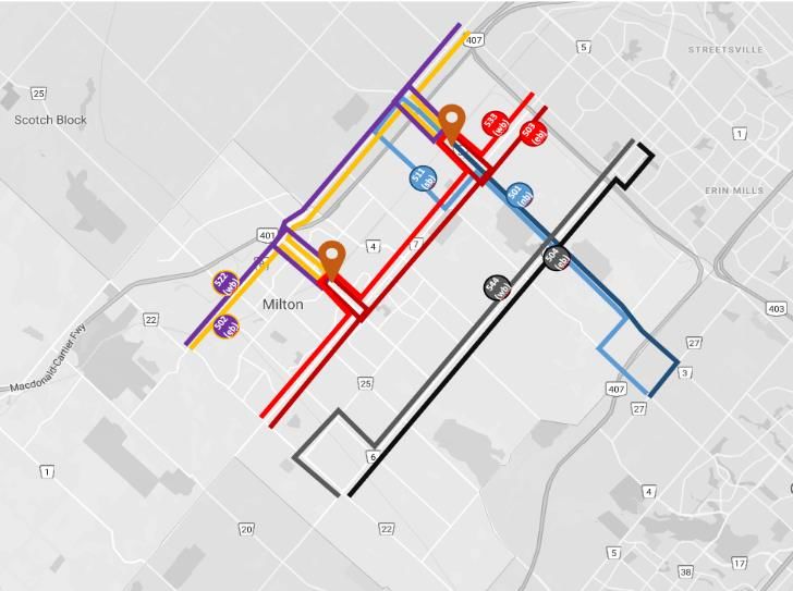
This reduction in auto use results in decongestion impacts, improved safety on the road network, and reduced
transportation-related emissions. The station should also alleviate parking pressure at the existing Milton GO
Station, which could allow the Town of Milton to unlock development potential in the vicinity of the existing station
and realize their vision in the Milton GO MTSA Study.
The IBC relies on the GGHMv4 regional travel demand model to assess the impacts of the proposed station. The
model generates key inputs to the Economic and Financial Case analyses, including station ridership, travel time
savings, and modal shift/auto usage changes for the 2041 AM peak period. Once quantified and monetized, these
benefits are not enough to outweigh the capital and operating costs necessary to build and operate the proposed
station over a 60-year evaluation period. The Economic Case thus results in a negative net present value of
approximately $40 million. However, from a financial perspective, the additional farebox revenue from new transit
riders does not entirely the additional burden on Metrolinx and results in net revenue of -$3.5M in present value
for the organization over the 60-year evaluation period.
In terms of deliverability, the site proposed for the station location reduces construction complexity, risks and
impacts while providing ample space for the station platform, tracks, and amenities. As a result of the existing
ownership along this section of the Milton GO line, Metrolinx would be required to seek permission from Canadian
Pacific (CP) Railway to build the new station and stop trains.
The table below summarizes the key findings for each Case.

 Strategic Case

 Strong Connections            • The proposed station will attract 2,000 boardings during the 2041 AM peak period, mostly
                                 representing diversions from nearby GO stations.
                               • Parking constraints will be alleviated at Milton GO with the introduction of the proposed station,
                                 which will attract transit users who live near to the proposed station and must park and ride at
                                 Milton GO under the BaU scenario.
                               • Opportunity to unlock land use potential for transit-oriented communities around the existing hubs.
                               • The proposed station should serve as a transit hub for local and regional connections.
                               • The site offers the opportunity to develop an employment node that integrates land use policy,
                                 transit planning, and economic development best practices.
                               • The station should protect for a second platform on the south side of the track in the case future GO
                                 service levels increase along the Milton GO line.

 Complete Travel Experiences   • The proposed station saves 5.6 million person-hours of travel over 60 years.
                               • PUDO Passengers diverted from Milton GO incur in-train travel time savings of 4.9 minutes and
                                 those diverted from Lisgar GO incur an in-train penalty of 4.0 minutes.
                               • Passengers boarding at Milton GO incur a travel time penalty of 2.8 minutes due to the additional
                                 dwell time at the proposed station.
                               • Station increases safety on the road network from reduced auto use to access nearby stations in the
                                 BaU scenario.
                               • Shift away from auto to transit or active modes of transportation to access the station reduces road
                                 congestion, especially on local roads near the existing stations.

 Healthy and Sustainable       • Modal shift from auto to transit or walk to access the station alleviates auto-related GHG emissions.
 Communities                   • Potential to prioritize pedestrian access by including sidewalks, crosswalk and multi-use paths within
                                 and around the station site to ensure safe and efficient movements of active transportation users.

vi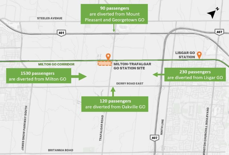
Economic Case

                                   • Travel Time Savings (Transit): $31.7 M - $33.3 M
                                   • Travel Time Savings (Auto): $8.71 M
                                   • Vehicle Operating Costs Savings: $3.6 M                                    $45.5 M - $47.1 M
 Total Benefits                    • Road Safety Outcomes: $1.1 M
                                   • Environmental Outcomes: $0.5 M

                                   • Incremental Fare Revenue Adjustment                                             $22.1 M

                                   • Capital Costs: $87.5 M
 Total Costs                                                                                                        $109.4 M
                                   • Operating and Maintenance Costs: $21.9 M

                                   • The range represents results for two modelling scenarios, one
                                     where demand for parking at Milton-Trafalgar GO is constrained by
                                     capacity and one where demand is parking unconstrained.
 Net Present Value                                                                                            $(40.2) M - $(41.8) M
                                   • Negative results indicate that the benefits, although positive, are
                                     not enough to outweigh the capital and operating costs for the
                                     proposed station.

                                   • A Benefit-Cost Ratio below 1.0 indicates that the project’s costs
 Benefit-Cost Ratio                                                                                                0.62 – 0.63
                                     outweigh the benefits.

                                   • Improvements to connectivity and accessibility to high-productivity employment hubs can make a
 Wider Economic Benefits             significant contribution to integrating the GTHA labour market outside the downtown core of
                                     Toronto and thereby contribute to improved productivity and competitiveness for the region overall.

 Financial Case

                                   • Comprised of the additional fares from new riders shifting away
                                     from auto or existing riders diverted from Lisgar GO less the lost
 Total Incremental Fare Revenue      revenue from downstream users who can no longer board because                   $22.1 M
                                     of reduced train capacity at Cooksville GO and further
                                     downstream.

                                   • The Proponent is expected to provide land and construction
                                     funding.
 Total Capital Costs               • Metrolinx to bear major mid-life station rehabilitation costs less              $11.9 M
                                     costs to maintain the parking lot, which falls under the
                                     responsibility of the Proponent.

 Total Operating and               • Metrolinx should bear operating and maintenance costs for the
                                                                                                                     $13.7 M
 Maintenance Costs                   proposed station, except for the parking lot.

 Net Revenue                       • Marginal net revenue loss for Metrolinx over 60 years.                          -$3.5 M

 Incremental Cost Recovery Ratio   • Ratio of incremental revenue to total costs borne by Metrolinx                    0.86

                                   • Ratio of incremental revenue to operating and maintenance costs
 Operating Cost Recovery Ratio                                                                                         1.61
                                     borne by Metrolinx

vii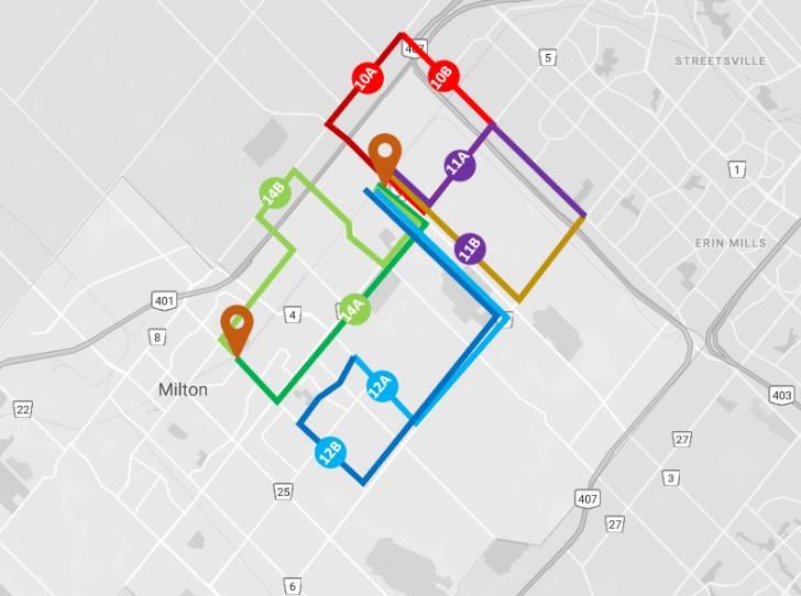
Deliverability and Operations Case

                                       • CP Railway owns and relies on this corridor as part of its Galt Subdivision – a critical and busy
                                         section of rail; part of its Montréal-Detroit freight corridor.
                                       • Metrolinx does not have control of this corridor and GO Transit services do not have priority.
  Project Stakeholders and
                                       • Metrolinx must enter into a negotiation with CP on operational and associated infrastructure
  Governance
                                         upgrades.
                                       • Hydro One owns the transmission tower infrastructure north of the rail corridor, further discussions
                                         needed to determine if the project can use their land to accommodate a portion of the parking.

                                       • Vacant site, existing agricultural uses – ample space to accommodate the proposed station.
                                       • New platforms and track grading could be installed through weekend work, minimizing service
                                         interruptions.
                                       • Construction of pedestrian tunnels between north and south platforms may impact mainline
                                         service.
  Constructability Considerations
                                       • Construction access from Trafalgar Road – potential need for signal control (short term and long
                                         term) and co-ordination with CP intermodal yard.
                                       • Culvert construction and grading may be required over Sixteen Mile Creek tributary – requires a
                                         review of environmental impacts.
                                       • Retaining walls may be required on the north platform depending on the topography.

                                       • Milton GO line is not currently identified for future two-way service, hence no proposed changes to
                                         service levels compared to today.
  Operations and Maintenance           • Additional riders boarding at the proposed station may reduce available capacity for downstream
  Considerations                         riders.
                                       • Stopped GO trains use the siding, not the mainline tracks to avoid any disruption to other rail
                                         services using the corridor (i.e., CP trains).

viii
1
Introduction
1Context Metrolinx has developed an Initial Business Case (IBC) for a potential new GO rail station on the south side of the Milton GO Corridor, west of Trafalgar Road. The station is being proposed as a market-driven initiative, with the IBC being completed at the request of the Town of Milton and a landowner’s group (collectively, the Proponent). The assessment builds upon previous work completed by Metrolinx and local stakeholders, including an analysis conducted for a station at this location in 2016 as part of the Metrolinx New Stations Assessment. Since then the Town of Milton and Halton Region have commissioned a number of plans and studies, including the Region’s Mobility Management Strategy which identifies Trafalgar Road as the north/south spine connecting the Town of Milton with local municipalities through higher-order rapid transit, and the Town of Milton’s 2018 Transportation Master Plan, which identifies the area around Derry and Trafalgar Roads as a Major Transit Station Area (MTSA). The identification of the MTSA was a key component in the development of both the Trafalgar and Agerton Employment Secondary Plans initiated by the Town of Milton in 2017. These plans establish a detailed planning framework and development concept for infrastructure and land use within the east Milton area. A common theme among these studies is the recognition of the importance of developing higher-order transit connections to accommodate forecasted population and employment growth within the Town of Milton. In September 2018, the Town of Milton also completed the Derry and Trafalgar GO Station Feasibility Analysis (Feasibility Study) which presented a case for early investment in a new GO station at Derry Road and Trafalgar Road. The Town of Milton has experienced rapid population and employment growth in recent years, increasing from 50,000 residents in 2006 to over 110,000 by 2016. This rate of growth is expected to continue to outpace the average growth rate in the Greater Toronto and Hamilton Area (GTHA), with the Town of Milton projected to have a population of 238,000 people by 20311. This population growth has resulted in increased demand for transit, especially at Milton GO Station, which already experiences congestion from riders who use auto to access the station. Moreover, expanding parking capacity is not a sustainable strategy, given the high cost for acquiring new land and the impacts on traffic congestion in and around the station area. The new community planned along the Trafalgar Corridor is expected to drive use of transit and active transportation to access the GO network via the proposed station. Adding a new station should relieve the demand for parking at Milton GO, allowing for more access to the GO network for people in the region. Initial Business Case Overview The purpose of this IBC is to determine if a new station on the south side of the Milton GO Corridor, west of Trafalgar Road would provide financial and broader societal benefits and be compatible with Metrolinx and regional strategic goals and objectives. In addition, the IBC identifies risks or barriers that may impact the implementation of the station as well as infrastructure and policy measures which may support its implementation. The IBC evaluates one investment option for a new GO rail station at Trafalgar Road against a Business as Usual scenario (BaU) (i.e., without a new station). The proposed station concept examined in this IBC was developed by Metrolinx in collaboration with the Proponents. The station concept is assessed using the methodology from the Metrolinx Business Case Guidance Volume 22. 1 Town of Milton. (2019). Derry and Trafalgar GO Station Feasibility Analysis. (Milton, ON, Town of Milton, 2019). 2 Metrolinx. (2018). Business Case Manual Volume 2: Guidance. 2
As with all Metrolinx Business Cases, this IBC is structured around four key cases:
•   The Strategic Case, which determines the value of addressing a problem or opportunity based on regional
    development goals, plans and policies;
•   The Economic Case, which uses standard economic analysis to detail the benefits and costs of the options to
    individuals and society as a whole, in economic terms;
•   The Financial Case, which assesses the overall financial impact of the options for Metrolinx; and,
•   The Deliverability and Operations Case, which considers procurement strategies, deliverability risks, and
    operating plans and risks.

                                                                                                                  3
2
The Case for Change
4Introduction
This chapter defines the Case for Change, which is used to guide the evaluation of the investment in the
proposed GO rail station within this initial business case framework.
Case for Change
Opportunity Statement
The Milton GO Corridor is an important part of the GTHA transportation network, currently providing
one-way weekday peak period train service between Milton and Toronto to serve a daily line ridership
of 7,000 passengers3.
A new station at Trafalgar Road presents an opportunity to develop infrastructure that can address
current and future population, employment, and ridership needs. The station and the development of
surrounding lands have the potential to be an exemplary complete community that achieves transit-
oriented community objectives through proactive and sustainable planning practices.
The proposed GO station should be a key component in attracting major employment and achieving the
Region’s and the Town’s employment growth targets. Given the proximity to two 400-series highways
and two future planned higher-order transit corridors – Trafalgar Road and Derry Road – the station
should also provide an important connection between the growing communities of Milton, Oakville,
Halton Hills, and Mississauga.
Bringing higher-order transit service to the Trafalgar area should not only provide localized benefits, but
should also play a critical role in unlocking development potential around the existing Milton GO Station
which is currently constrained by largely auto-oriented infrastructure and increasing congestion.
Planned improvements have been proposed to the existing Milton GO Station to enhance users’
experience by expanding the parking capacity. However, this solution is expected to only relieve
congestion in the short term and issues may arise again as a result of long-term population and
employment growth. The proposed station has the potential to alleviate parking pressure and provide
access relief at the existing Milton GO Station, which could allow for ridership growth to be realized.
3 Metrolinx. (2018). GO Expansion Full Business Case.
5Key Drivers
Table 1 identifies the main drivers for this opportunity and summarizes how these drivers may influence
the case for the new GO station.
Table 1: Opportunity Drivers
How does this Driver influence the What is the impact of not addressing the
Driver
problem/opportunity? problem/opportunity?
Future population and employment growth in the Lack of improvement in accessibility to
Agerton Employment Area and the Trafalgar higher-order transit in the area may result in
Secondary Plan Area drives the need for higher- mode shift to auto and further increase
Internal to the Transportation Network
Travel Behaviour order transit within the area. road congestion, resulting in longer
Improving station access/egress efficiency and commute times, loss of productivity, and a
easing parking constraints may facilitate a modal reduction in road safety and air quality.
shift towards transit and active transportation.
Increased rapid transit coverage should reduce No increases in service provisions would
crowding at the existing Milton GO Station where result in continued auto congestion at
parking operates at capacity and experiences access Milton GO Station, which will be
congestion from customers who use auto to access exacerbated by forecast population and
Transport Service
the station. employment growth.
Provision
Potential new ridership and associated incremental Failure to increase rapid transit coverage
farebox revenue should be realized by the GO limits access to economic, cultural, and
network by providing an additional access option at social opportunities in the MTSA and
Trafalgar Road. surroundings.
The Agerton Employment and Trafalgar Secondary Without a station, there would be a lack of
Plans have both recognized this station location as incentive to develop a dense, transit-
an area of opportunity to accommodate higher accessible live-and-work community.
density development and taller built form.
External to the Transportation Network
Government
Policy and Within the Halton Region Official Plan, the station
Planning site land is designated as an urban area. The
proposed station is an opportunity to achieve the
objectives of integrated population and
employment growth in a planned community.
The Agerton Employment Secondary Plan intends to The inability to address the development
initiate the development of a MTSA and encourage needs of specific areas of growth would
the attraction of 6,800 residents and 15,000 jobs hinder economic activity and miss the
Economic Activity,
over 20 years. opportunity to transform the community
Land Use, and into a new high-value employment
Demographics The Trafalgar Secondary Plan sets out to encourage
growth along the corridor with a minimum destination.
population of 26,000 residents and 4,000 jobs
within the 2031 planning horizon.
6Business as Usual
If the investment in the proposed GO station is not pursued, demand for higher-order transit services on
the corridor would be served by twelve trains stopping at existing stations (increased from ten today) in
each peak direction during the morning and afternoon peak periods. Metrolinx does not currently
envisage GO Expansion service levels along the Milton GO line. However, Metrolinx continues to explore
how to operate a two-way, all-day service along this corridor with CP Rail4.
The existing Milton GO Station is well utilized, with parking operating at capacity today. Despite
Metrolinx’s plans to add 850 spaces to the existing station in the next few years, parking is projected to
still operate at capacity in 2041 under the BaU. In the medium to long term, parking challenges will
continue as demand for parking will outpace parking supply. These parking constraints are expected to
impact ridership potential and may hinder growth on the line. The congestion at or around the existing
station also contributes to less sustainable travel choices. GO users who drive to/from the station may
choose to travel longer distances in search of parking at an alternative station or in place of rail travel
altogether.
Strategic Outcomes and Objectives
The proposed station should support the realization of the Metrolinx 2041 Regional Transportation Plan
goals of creating strong connections, complete travel experiences, and sustainable and healthy
communities5. These goals would be achieved through the station’s ability to connect new mixed-use
communities with higher-order transit service and reduce reliance on auto use in the area. Figure 1
summarizes the three RTP goals.
Figure 1: 2041 RTP Goals
Complete Travel
Connecting people to the Experiences Investing in transportation for
places that make their lives today and for future
better, such as homes, jobs, Designing an easy, safe, generations by supporting
community services, parks accessible, affordable and land use intensification,
and open spaces, recreation, comfortable door-to-door climate resiliency and a low-
and cultural activities. travel experience that meets carbon footprint, while
the diverse needs of leveraging innovation.
travellers.
Sustainable and
Strong
Healthy
Connections
Communities
4 Metrolinx. (2018). GO Expansion Full Business Case.
5 Metrolinx. (2019). 2041 Regional Transportation Plan.
7The 2041 RTP goals are used as a basis to define three strategic outcomes for the proposed Milton-
Trafalgar Station, which are as follows:
Strong Connections | The proposed station should improve transit coverage, offer access to rapid
transit to more communities, and serve key destinations. Improvements can be made to the current
situation by investing in the proposed station while also considering opportunities to support future
network expansion in the station catchment area.
Underlying benefits:
▪ Promote land-use intensification and encourage transit-oriented communities;
▪ Improve access to local and regional destinations; and,
▪ Provide transit investment that can expand for future growth.
Complete Travel Experiences | Ease of travel as a result of the proposed station will allow people to
access different destinations at more convenient times. Daily lives of passengers will benefit from the
reduced travel time and costs offered by the proposed station. The station design should provide an
easy, safe, and comfortable travel experience that meets the diverse needs of travellers.
Underlying benefits:
▪ Increase parking capacity on the Milton GO line;
▪ Reduce travel times; and,
▪ Improve safety on the road network.
Healthy and Sustainable Communities | The location of the proposed station supports land-use
intensification, GO rail accessibility and reduced reliance on the automobile. Land use and development
patterns that utilize mixed-use, transit-supportive, and pedestrian-friendly urban environments can save
energy, improve air quality, and support climate resilience through reductions in carbon emissions. An
integrated transportation network in the Town that provides people with improved access should help
encourage more sustainable transportation behaviours and reduce the reliance on the private
automobile.
Underlying benefits:
▪ Encourage the use of active modes to access the GO rail network; and
▪ Improve air quality and reduce transportation-related emissions.
Alignment with Broader Policy
The proposed investment should contribute to provincial, regional, and local policy and planning
objectives. These objectives aim to improve the quality of life and safety, guide economic growth and
development, and achieve environmental sustainability throughout the region. A review of provincial,
regional, and municipal policies and plans has been conducted to assess how the proposed station aligns
with policies in the documents. Table 2 summarizes the key considerations and alignment with broader
policies.
8Table 2: Summary of Alignment with Broader Policies
Author Document/Policy Key Considerations
The proposed investment aligns with four key strategies proposed to achieve the
2041 RTP goals. The strategies are as follows:
• Strategy 2 – Connect more of the Region with Frequent Rapid Transit: the
proposed station is expected to provide increased transit access and will
connect more people with destinations while offering transit as an
attractive alternative to driving.
• Strategy 3 – Optimize the Transportation System: alleviate crowding issues
and improve auto/pedestrian safety due to congestion at the existing
Milton GO Station.
2041 Regional • Strategy 4 – Integrate Land Use and Transportation: As one of the largest
Metrolinx Transportation Plan undeveloped areas and a designated area of growth in the Town of Milton
(2018) and Halton Region, the proposed station is an opportunity to incorporate
transit-oriented community principles to serve the anticipated growth of up
to 25,000 new employees in the region. The proposed station also creates
the opportunity to unlock the potential for transit-oriented communities
and improvements to multimodal access around the existing Milton GO
Station.
• Strategy 5 – Prepare for an Uncertain Future: The existing Milton GO station
already operates at capacity for autos and is expected to experience steady
ridership increases. The proposed station provides a new connection should
increase service be implemented along the Milton GO corridor in the
future.
Section 2.2.4 states that “all major transit station areas will be planned and
designed to be transit-supportive and to achieve multimodal access to stations
and connections to nearby major trip generators by providing, where
appropriate:
• connections to local and regional transit services to support transit service
Ministry of
integration;
Municipal
Places to Grow (2019) • infrastructure to support active transportation, including sidewalks, bicycle
Affairs and
lanes, and secure bicycle parking; and
Housing
• commuter pick-up/drop-off areas.”
The proposed station area has been identified as a future mobility hub in local
policy documents and is expected to be a catalyst for strategic growth areas
(MTSA and the Downtown Milton Urban Growth Centre) by enhancing
transportation options, transit supportive communities and infrastructure.
The Regional Official Plan sets out population and employment targets to guide
Regional Official Plan growth in Halton Region. The Official Plan identified the proposed MTSA in the
vicinity of Derry and Trafalgar Roads and identified Trafalgar Road as a higher
(2016)
order transit corridor. The Trafalgar and Agerton Employment Secondary Plan
Areas have been identified in the Official Plan as Urban Areas beyond 2021.
Halton Region This study identifies where regional infrastructure investment needs to occur in
Defining Major Transit order to unlock transit-oriented growth and enhanced connectivity and mobility
Requirements in Halton in the Region. A priority bus corridor is proposed along Trafalgar Road between
Region Study Steels Avenue to midtown Oakville GO as part of the Preliminary 2031
Recommended Transit Priority Corridor Network. This study also identifies to
(2019) the Milton-Trafalgar proposed station as a Regional Transit Node in the
Preliminary 2031 Transit Network.
9Author Document/Policy Key Considerations
The Mobility Management Strategy was developed based on the concept of the
mobility-as-a-service model, which provides users with the option to travel
between a point of origin and destination through the most efficient or
Mobility Management desirable means, whether it be through transit, active transportation, ride-
Strategy (2016) sharing, etc.
The area around the Milton GO corridor at Trafalgar Road was identified as a
proposed MTSA and regional transit node to support future urban growth in
northeast Milton and to serve as alternative access to the GO Rail network.
The Official Plan, consolidated in 2008, establishes Council’s priorities and
policies on land use planning and development in the Town of Milton. In 2010,
the Town adopted Official Plan Amendment No. 31 which implements
Official Plan (2008) population (239,000) and employment (114,000) targets for Milton to 2031.
The Trafalgar Corridor is an attractive development opportunity for a transit
station and transit-supportive community to accommodate these residential and
employment growth targets.
The Town’s Strategic Action Plan, Destiny Milton 3, established a strong focus on
complete, sustainable and livable communities, where people live, learn and
play. In September 2017, Council endorsed the Town’s Future Urban Structure
report which envisions the Trafalgar Corridor to be developed as a mixed-use,
high-density corridor to support the extension of higher-order transit and the
proposed MTSA around Derry and Trafalgar Roads.
Strategic Plan (2015)
A first principle of growth is the delivery of employment to residential ratio of
one job for every two residents with an emphasis on knowledge-based jobs. The
planned employment area around the proposed station offers an attractive
option for employers from various sectors seeking an urban lifestyle complete
with the amenities that the next generation of employees are looking for in an
affordable transit-connected environment accessible to the broader region.
Town of
Milton The Transportation Master Plan (“TMP”) addresses current and future needs of
transit users, pedestrians, cyclists and drivers in a community that is
experiencing a continuous stream of new urban development. The TMP includes
transit-oriented design guidelines that create a balanced transportation system
Transportation Master
by encouraging transit-supportive communities and promoting active
Plan (2018)
transportation.
The introduction of a GO station at the Trafalgar site should encourage greater
use of transit and will reduce reliance on car-based transportation and increase
investment in transit infrastructure.
The Trafalgar Secondary Plan envisions the Trafalgar Corridor to be developed
as a mixed-use, higher density corridor which supports the extension of higher-
order transit. A key planning objective for the Trafalgar Corridor (which
encompasses both the Agerton Secondary Plan and Trafalgar Secondary Plan) is
Trafalgar Secondary Plan to sanction the delivery of key transportation and higher-order transit service
(2019) along Trafalgar Road (inter- and intra-regional). It will also support the
realization of a Major Transit Station, facilitate expedited servicing delivery to
the employment areas, and support the achievement of employment forecasts
in the Town of Milton.
10Author Document/Policy Key Considerations
The Agerton Employment Secondary Plan envisions the development of mixed-
use employment and higher density residential community which supports the
extension of higher-order transit. Through the Regional Official Plan
Amendment ("ROPA") 38, a proposed major transit station was identified in the
vicinity of the intersection of Derry and Trafalgar Roads within the Agerton
Secondary Plan area.
Agerton Employment
Secondary Plan (2019) The Agerton Secondary Plan provides detailed policies to facilitate the
development of a MTSA within the proposed station area. The MTSA is a
planned urban area with an approximate 500-meter radius of the proposed
station that is a focal point of strategic intensification with an abutting medium-
to high-density mixed-use community and employment lands between the
hydro corridor and Derry Road, as well as an office priority Employment Area in
the northern portion of the plan, between Highway 401 and the hydro corridor.
113
Investment Option
12Introduction
This chapter presents the study area and prevailing conditions under the Business as Usual scenario as well as an
initial concept plan for the proposed station.
Study Area
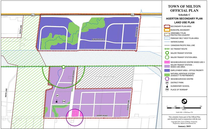
The land proposed for the station site is subject to the Town of Milton Official Plan as well as to the Halton Region
Official Plan. Under the Town of Milton Official Plan (OP), the subject lands for the station site, which currently
consists of undeveloped area designated as Agricultural Area. The subject lands are within the Urban Expansion
areas from 2021 to 2031, as identified in the Town’s Official Plan Update (OPA 31) and will be considered an Urban
Area as of 2021. Within the Halton Region OP, the station site land is designated as an urban area. Both the Town of
Milton and Halton Region Official Plans are currently under review and are being updated.
The land that surrounds it to the north and east is designated as Prime Agricultural Areas and to the west is
Greenbelt Plan Protected Countryside Area, and therefore are subject to specific policies in the Greenbelt Plan
(2017); however no station elements are anticipated to be located within Greenbelt protected lands. The station is
also located within the lands of the Treaty 14, Head of Lakes Purchase with the Mississaugas of the Credit First
Nation.
The following elements are within the vicinity of the station site:
• North: To the north beyond the hydro corridor that runs parallel to the rail corridor, there is additional
undeveloped land with some commercial properties along Trafalgar to Highway 401. This land is designated as
Parkway Belt West Plan Area in the existing OP, which is a special planning area designated for linear facilities
and to provide a boundary to adjacent urban areas. The proposed land use in the Agerton Secondary Plan is
“Employment Area – Office Priority.” Toronto Premium Outlets is also located north of this area (approximately
2 km) at the intersection of Trafalgar Road and Steeles Avenue, which is an important trip generator.
• East: The area between Trafalgar Road and Eighth Line is designated as urban area with the exception of the
“CP Lands”, which contain an intermodal freight rail facility. This site is designated as “Future Urban Area” in
the Agerton Secondary Plan.
• South: There are two existing properties to the southeast and two existing properties on the southwest corners
of the proposed station site. Beyond these properties, between the site and Derry Road, there is more vacant
land that is designated Agricultural Area in the existing OP and designated as “Mixed-Use” in the Agerton
Secondary Plan. In the area extending from the Milton GO corridor to south of the station site, there is
evidence of wetland vegetation and a watercourse flowing south.
• West: To the west of the station site is vacant land, some containing environmental features including Sixteen
Mile Creek and small body of water. In the OP (OPA 31), the land is designated as “Natural Heritage System” as
per the Greenbelt Plan. Future consideration will be given to ensure any structure is appropriately sized and
designed to mitigate current and future climate risks.
Figure 2 depicts the proposed station site, the study area, the surrounding transportation network, and designated
land-uses.
13Figure 2: Study Area Existing Features and Planned Land Uses (From Town of Milton Agerton Secondary Plan) 14
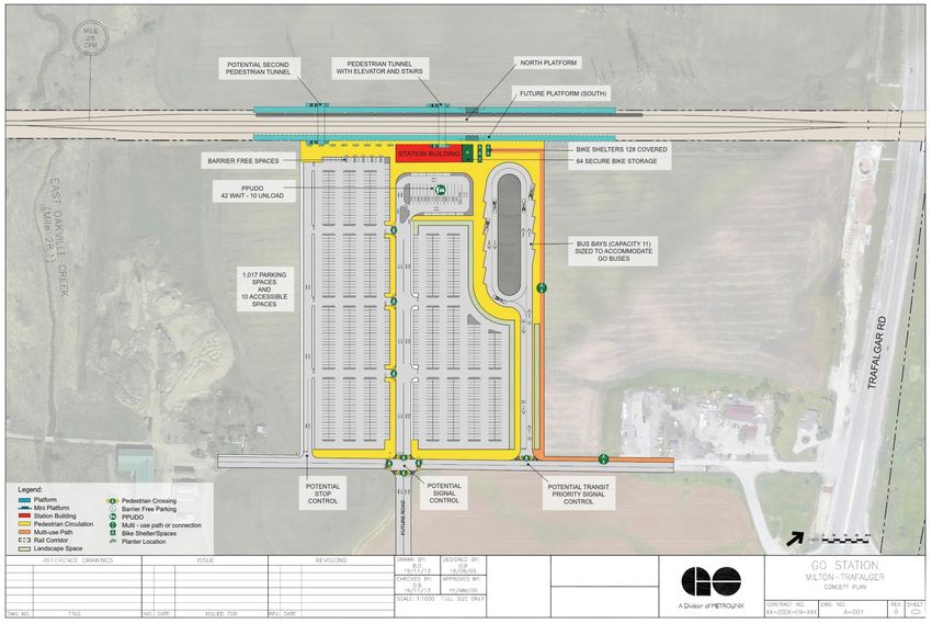
Station Concept Plan
The concept plan presented in this section is intended to provide a basic design illustrating the scale of the site and
station amenities. For the purposes of this market-driven IBC, the concept plan is considered representative in
nature and is only to be used for the purposes of cost estimating and facility sizing for input to the IBC analysis. It is
expected that the ultimate station configuration and arrangement would be determined by the Proponent with
requirements set by Metrolinx. The station concept plan is presented in Figure 3.
Track and Platform Arrangement
The Milton GO Corridor at the subject location is currently comprised of two mainline tracks. This IBC considers the
opening-day addition of a north siding track servicing a new north side platform. The additional platform and track
on the north side of the mainline tracks are considered as the minimum requirement for station operations,
considering that the current peak-direction service on the Milton line utilizes the existing north track. Therefore,
stopped trains should not impact other freight operations along the corridor. The concept plan protects for a south
platform and siding track, which may be required in the future if two-way all-day service or other service
improvements are implemented on the Milton line.
The north and future south siding tracks turn out from the mainline tracks to the west of the Trafalgar Road
overpass and over the tributary of the Sixteen Mile Creek; track turnouts may require the existing culvert over the
creek to be widened or reconstructed, subject to additional study and detailed track design.
Widening to account for the north track and platform brings the station platform and track in proximity to the
existing hydro corridor. A detailed review of the feasibility of constructing the new north platform in proximity to
the hydro corridor was not conducted as part of this IBC as technical data and mapping were not available. A
detailed grading assessment, in addition to discussions with the utility would be required to confirm impacts.
Station Amenities
Station sizing parameters were estimated based on ridership forecasting conducted by Metrolinx using the Greater
Golden Horseshoe Model version 4 (GGHMv4). The analysis produced the following station amenities sizing
requirements:
•   Parking Lot - 1000 parking spaces
•   Passenger Pick-up/Drop-off – 40 wait spaces; 10 load spaces
•   Bike Parking – 128 covered spaces; 64 secure spaces
•   Transit – 9 bus bays for local routes; 2 bus bays for GO bus routes
Access to the station site from Trafalgar Road is anticipated to be provided via a signalized intersection with an
east-west collector road south of the Trafalgar Road overpass. The precise location of this east-west collector road
should be evaluated further by the Town of Milton. However it should be noted that because of grade differences
resulting from the Trafalgar Road overpass, it is not likely that it can intersect with Trafalgar Road further north
than what is shown in the concept plan. This new road leads to a bus-only entrance to the bus loop, a signalized
main access to the pick-up/drop-off areas (PUDO) and parking lots, and secondary minor access to the parking at
the far west side of the site. These intersections should be coordinated with the future Agerton Secondary Plan
road network.
The bus loop includes 11 bus bays, all sized to accommodate GO buses, in a standard sawtooth configuration. The
location of the bus loop on the east side of the site close to the station building shortens travel times from Trafalgar
Road and provides direct access for riders originating at/destined to development between the station site and
Trafalgar Road.
Pedestrian and cyclist access to the site is provided via a multi-use path on the north side of the east-west collector
road, leading into the site adjacent to the bus loop and terminating at the bike parking facilities to the east of the

                                                                                                                        15
station building. Pedestrian crossings at the main station access and generous pedestrian space leading from the east-west collector road to the station building provide safe and efficient pedestrian access from developments south of the station. The location of the PUDO is situated to prioritize passenger pick-up/drop-off over park and ride passengers; immediately adjacent to the station building. The main station access road, while shared with park and ride users, provides priority for vehicles accessing/egressing the PUDO and uses stop controls for the parking lot drive aisles. The east and west parking lots are approximately equal in capacity and are divided by the station access road. The secondary parking lot access on the west side of the site provides redundancy and greater egress capacity. 16
Figure 3: Milton-Trafalgar GO Station Concept Plan

                                                     17
4
Strategic Case
18Introduction
The Strategic Case sets out the rationale for proceeding with the proposed station investment and provides key
criteria including the relationship to market demand, social and environmental impacts, network connectivity, and
accessibility improvements.
This chapter uses the three strategic outcomes and their associated benefits to determine how the implementation
of the proposed GO station aligns with local and regional policy goals. The three strategic outcomes are as follows:
• Strong Connections;
• Complete Travel Experiences; and,
• Sustainable and Healthy Communities.
Strategic Outcome 1: Strong Connections
The proposed station is expected to play a key role in accommodating future population and employment growth in
the region by supporting the objectives of transit-oriented communities. The station is expected to provide relief to
the existing Milton GO Station, where parking capacity has been reached today. Reducing parking pressure could, in
turn, unlock the development potential of the land surrounding the existing station and achieve the visions outlined
by the Town of Milton in their MTSA study. Moreover, improved connectivity to local transit and the GO rail
network will provide more opportunities for mobility and accessibility within the Town of Milton and to the
surrounding areas.
This section assesses the proposed station’s ability to achieve the three benefits that support the realization of the
“Strong Connections” outcome, namely:
• Promote land-use intensification and encourage transit-oriented communities;
• Improve access to local and regional destinations; and,
• Provide transit investment that can expand for future growth.
Benefit 1: Promote land-use intensification and encourage transit-oriented communities
To maximize the benefits of a proposed station investment, transit infrastructure should not only be built where
people reside and jobs are located today, but also where there is potential for growth in the future. The proposed
station is expected to bolster land-use intensification around the station site and support development around the
existing Milton GO Station.
Being an undeveloped site, the proposed station site currently has minimal population and employment density
with agriculture being the primary land use. This area is physically separated from the Milton urban area by the
Sixteen Mile Creek Valley. The site provides an opportunity to accommodate higher density development and taller
buildings in a way that contributes positively to the overall urban structure 6. The site provides a rare opportunity to
develop an exemplary complete community that achieves transit-oriented built form, rather than retrofitting and
trying to fit a proposed station within an already built and potentially constrained area.
Taking advantage of this unique opportunity, the Trafalgar and Draft Agerton Employment Secondary Plans have
established a detailed planning framework and development concept for infrastructure and land use that supports
intensification along the Trafalgar Corridor and surrounding the proposed station site. The Agerton Employment
Secondary Plan intends to initiate the development of an MTSA and encourage the attraction of 6,800 residents
and 15,000 jobs over 20 years. The Trafalgar Secondary Plan sets out to encourage growth along the corridor with a
minimum population of 26,000 residents and 4,000 jobs within the 2031 planning horizon.
The Draft Agerton Secondary Plan stipulates that the MTSA is intended to provide a full mix and range of uses
within a 500-metre radius of the proposed station with a minimum overall density of 300 residents and jobs per
6 Town of Milton. (2019). Derry and Trafalgar GO Station Feasibility Analysis.
19hectares. This density is considered transit-supportive, according to Metrolinx’s density guidelines for express rail stations (150–300 P+J/ha)7. Tall buildings and mid-rise buildings are encouraged within the MTSA while low-rise buildings (fewer than four storeys) are prohibited. The proposed station is not only expected to benefit from and contribute further to land use intensification around the Trafalgar Corridor, but it is also expected to alleviate parking pressures at the nearby Milton GO Station. Reduced demand for parking should provide the opportunity to unlock land for transit-oriented communities around the existing stations. The Milton GO Station is located within a provincially designated Urban Growth Centre, a focal area for investment in institutional and region-wide public services, major transit infrastructure, and the accommodation of a significant share of population and employment growth8. In May 2020, the Milton Major Transit Station Area and Mobility Hub Study was completed which provides recommendations to guide the transformation of the Milton GO Station and surrounding area (800 m radius) into a transportation hub with pedestrian-oriented streetscapes and mixed-use communities. At full build out, the area extending from Milton GO Station to Main Street East, Thompson Road South and Ontario Street South (i.e. the Primary and Secondary Zones) are expected to have a total of 25,100 residents and 4,100 jobs9. Recognizing that park-and-ride may be an important mode of access for the existing Milton GO Station, an additional 850 spots will be provided at the existing station as a short-term solution to parking constraints. In the medium to long term, parking challenges may continue at the station as demand for parking could outpace parking supply. The proposed station could provide the relief necessary at the existing stations to release lands currently used for parking. For business case analysis purposes, land use inputs are held constant in the GGHMv4 for the BaU and the proposed station scenario to ensure that a consistent base of comparison is provided between scenarios. As such, real estate developments and projected population and employment surrounding the proposed station are assumed to exist even in the BaU scenario10. These assumptions are common practice across all Metrolinx IBCs in order to isolate the benefits and costs of the proposed station and avoid conflating the impact of the proposed station with the impact of the development on travel demands. However, it is recognized that this methodology does not reflect the fact that the proposed Secondary Plan developments are contingent on the proposed station. If the proposed station is not constructed, the Milton- Trafalgar area may be less attractive to future employers and residents, resulting in a lost opportunity for transit- oriented communities surrounding the MTSA. Further, deferring this infrastructure investment would result in exacerbated parking constraints at existing stations which may result in increased traffic congestion, reduced ridership, lost revenue and more lost opportunities for transit-oriented communities. It is recognized that even if the proposed station is implemented, there is a risk that the planned development identified in the Agerton Employment Secondary Plan does not occur. This would result in an “island station” at the Milton-Trafalgar location, which is a standalone station with minimal commercial, residential or mixed land uses in its vicinity, resulting in passengers accessing it primarily by auto. 7 Metrolinx. (2011). Mobility Hub Guidelines for the Greater Toronto and Hamilton Area. 8 Neptis. (2013). Implementing the Growth Plan for the Greater Golden Horseshoe. 9 Town of Milton. (2020). Milton Major Transit Station Area & Mobility Hub Study Final Report. 10 In the Agerton Employment Secondary Plan Draft, the MTSA is identified as a contiguous urban area surrounding the proposed station. 20
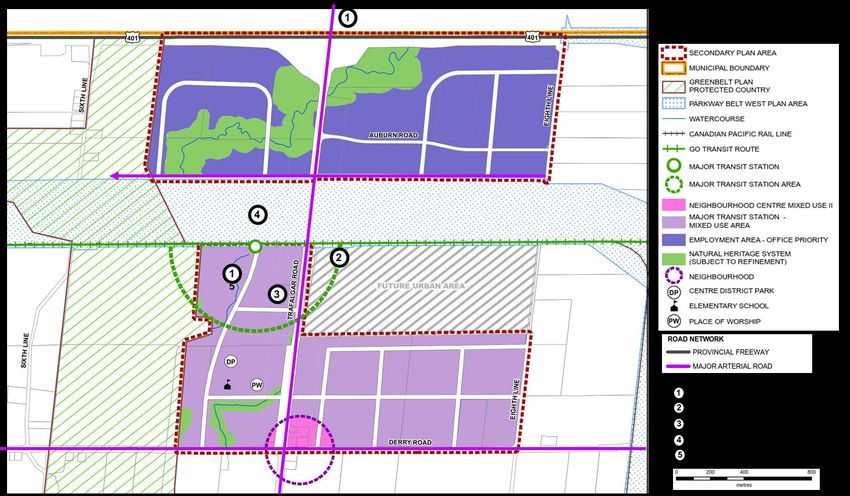
Figure 4: Milton-Trafalgar and Agerton SPAs

                                              21
Benefit 2: Improve access to local and regional destinations
A key objective for the project is to improve users’ access to local and regional destinations, business nodes, and
employment centres through increased accessibility to transit services. Enhancing transit infrastructure, particularly
in areas posed for urban growth, will improve connectivity to existing and future employment clusters and
residential communities.
Under the BaU scenario, people who live and work around the proposed station need to travel to nearby stations to
access the GO rail network, either by car or by transit. With the proposed station, residents and workers will have a
more direct and faster access to the network, which will promote the use of active modes of transportation.
Improved connectivity will also be achieved through the integration of the new GO station with local and regional
bus services in the broader northwest GTHA including the Mississauga MiWay transit system, Brampton Transit,
Oakville Transit, and Milton Transit. Several local and regional transit routes have been planned to serve the new
station site in the 2041 AM peak period, which will provide additional connections for people who live, work, and
play along the immediate Trafalgar corridor area and the surrounding region.
Given its proximity and accessibility to other major transportation connections such as Highway 401, Highway 407,
and Derry Road West, the proposed station should become a complete multimodal mobility hub in the medium to
long term. Table 3 details the transit services and route assumptions within the study area considered in the
GGHMv4 for the 2041 AM peak period.
Table 3: Proposed Local and Regional Routes within the Study Area
Service Routes Service Description
Local Bus 10A/B – Derry NE • Stops at all intersections and connectors
11A/B – Derry SE • 15 min peak headway / 30 min off-peak
12A/B – Derry SW
14A/B – Derry NW
Regional Bus 501(NB) / 511(SB) – Trafalgar North / South • Stops at all intersections and connectors
• 10 min peak headway / 20 min off-peak
502(EB) / 522(WB) – Steeles East / West • Stops at all intersections and connectors
• 15 min peak headway / 30 min off-peak
503(EB) / 533(WB) – Derry East / West • Stops at all intersections and connectors
• 15 min peak headway / 30 min off-peak
504(EB) / 544(WB) – Britannia East / West • Stops at all intersections and connectors
• 15 min peak headway / 30 min off-peak
In the short term, the station will be served by GO trains operating during peak periods in the peak direction.
However, it is important to consider the effect of improved bus services at the nearby Oakville GO Station as a
result of GO Expansion service levels on the Lakeshore West line. Located at the intersection of Trafalgar Road and
the QEW Highway, Oakville GO is served by a combination of all-day GO service, express GO service, VIA Rail, and
expanded bus service as a precursor to the north-south Trafalgar BRT project. This expanded bus service can
provide a connection between the new station and the regional rapid transit network via Oakville GO. Figure 5 and
Figure 6 illustrate the local and regional transit route assumptions within the study area, respectively.
22Figure 6: Regional Transit Route Assumptions (2041) Figure 5: Local Transit Routes Assumptions (2041)
In addition to serving as a transit hub for local and regional connections, the new GO station should enable the
development of an employment area intended to provide a range and mix of employment and retail uses11. The
new station has the potential to provide additional options to commuters through an efficient transit connection
for businesses in the region. The planned employment area offers an attractive option for employers seeking an
urban lifestyle complete with the amenities that the next generation of employees are looking for in an affordable
transit-connected environment.
Currently, the greater region of southern Ontario has three major office employment nodes: Downtown Toronto,
Markham-Richmond Hill, and the Highway 401 corridor between Airport Corporate Centre and Meadowvale. As
illustrated in Figure 7, the proposed MTSA would be an extension of the Highway 401 corridor employment node
located between Meadowvale and Milton. The site provides a unique opportunity to develop an employment area
that incorporates best practices for land use policy, transit planning and economic development. Demand for land
around the MTSA arises from its location relative to important regional nodes and connections such as downtown
Toronto, Pearson Airport, and two major trade corridors leading to the U.S. The site is also located immediately
abutting the Kitchener/Waterloo Toronto Innovation Corridor, where many organizations have launched initiatives
to attract high-tech jobs12.
11 Town of Milton. (2019). Agerton Employment Secondary Plan Draft.
12 Town of Milton. (2019). Derry and Trafalgar GO Station Feasibility Analysis.
23Figure 7: Major Office Employment nodes in the GTHA13 Benefit 3: Provide transit investment that can expand for future growth The initial concept plan includes one platform on the north side of the tracks, although a second platform on the southern track has been protected for in the event that two-way service is implemented on the Milton GO corridor in the future. Further design and analysis would be required to determine the feasibility of additional tracks and property requirements for potential overhead contact system infrastructure in the case of electrification. Potential spatial constraints around the Trafalgar Road overpass, hydro corridor and culvert at the Sixteen Mile Creek tributary would require further investigation to ensure the feasibility of the proposed station concept and track configuration. Strategic Outcome 2: Complete Travel Experiences The proposed station would help residents and employees within and surrounding the Town of Milton to achieve a higher quality of life by reducing travel times and providing an easy, safe, and comfortable travel experience. This 13 Strategic Regional Research Alliance. (2015). The Future of Office Development in the GTHA. 24
enhanced passenger experience will meet the diverse needs of all transit users and make transit a more attractive
mode of transportation.
This section assesses the proposed station’s ability to deliver the three benefits that support the realization of the
“Complete Travel Experiences” outcome:
•     Increase capacity on the Milton GO line;
•     Reduce travel times; and,
•     Improve safety on the road network.
Benefit 4: Increase capacity on the Milton GO line

The proposed station is expected to attract 2,000 riders during the AM peak period of a typical weekday in 2041.
These riders consist of existing GO riders who board at nearby stations under the BaU Scenario. These diversions
are primarily comprised of passengers from Milton GO and Lisgar GO stations, with 1,530 passengers from Milton
GO and 230 passengers from Lisgar GO diverting their trips to the proposed station. An additional 90 passenger
diversions are observed from Georgetown GO and Mount Pleasant GO and 120 passengers are expected to divert
from Oakville GO, despite shorter travel times on the Lakeshore West GO line, in favour of comfort, better
accessibility to the station, and a less crowded commute. This is represented graphically in Figure 8.

    Figure 8: Ridership Diversions, 2041 AM Peak Period

The model anticipates negligible gain in net new daily boardings on the GO system. This is in part because the
GGHMv4 considers the Milton GO line to be operating at capacity in 2041, even under the BaU scenario. As such,
any new boarding results in someone not able to board further downstream. Improvements in line capacity or
service frequency would likely attract new transit riders to use the proposed station in the future. As a result of CP
ownership of the corridor, electrification and level boarding are not currently possible on the Milton line.
Benefit 5: Reduce travel times
In 2041, passengers using the proposed station are likely to live or work in the vicinity of the station. Under the BaU
scenario, these users drive, are dropped off or use local transit to access the closest or most accessible station. The
proposed station is expected to reduce travel times for existing transit users through faster station access and
station diversion and for auto users remaining on the road network through reduced congestion on the local road
network.

                                                                                                                         25
You can also read