Nord Stream 2 Monitoring Strategy Germany - W-PE-EMO-PGE-SOW-800-MONITOEN-01 Nord Stream 2 AG | May-18
←
→
Page content transcription
If your browser does not render page correctly, please read the page content below
Nord Stream 2 Monitoring Strategy
Germany
Nord Stream 2 AG | May-18

W-PE-EMO-PGE-SOW-800-MONITOEN-01

Page 2 of 48

                                                         Content
1 Monitoring Strategy Germany ..................................................................................... 3
2 Environmental Construction Supervision onshore (2018-2020) ............................... 3
 2.1       S1, S2 – Protection of soil and groundwater ........................................................... 9
 2.2       S3, S4, M13 – Construction fence, amphibian strand guide .................................. 10
 2.3   M9, M11, M12 – Construction period limitations, reduction of noise and light
 immissions to protect breeding birds and bats ................................................................. 11
 2.4       M10, CEF1 & 2 – Bat sites and nesting boxes for starlings ................................... 12
3 Environmental Construction Supervision offshore, territorial waters M-WP
(2018/2019) ...................................................................................................................... 13
 3.1       M 1/M 2/M 3 Dredging strategy ............................................................................. 15
 3.2       M 4/M 5 Turbidity monitoring ................................................................................. 16
 3.3       Traffic monitoring .................................................................................................. 20
4 Environmental Construction Supervision offshore, continental shelf (2018/2019)21
5 Construction monitoring ........................................................................................... 22
 5.1       Underwater noise measurements ......................................................................... 22
 5.2       Staging birds ......................................................................................................... 24
 5.3       Harbour porpoises ................................................................................................ 25
 5.4       Grey seals ............................................................................................................ 26
6 Documentation of the environmental conditions on completion of the pipe-laying
process (2019/2020) ........................................................................................................ 28
 6.1       As-built survey ...................................................................................................... 28
 6.2       Sediment parameters............................................................................................ 28
7 Monitoring of the regeneration of habitat types at Natura 2000 sites under the
Habitats Directive affected by construction work (2019-2022) .................................... 29
 7.1       Habitat types under the Habitats Directive /marine biotopes ................................. 29
    7.1.1        Morphology of the seabed.............................................................................. 29
    7.1.2        Sediment parameters..................................................................................... 29
    7.1.3        Macrozoobenthos – infauna ........................................................................... 30
    7.1.4        Macrozoobenthos – epifauna, Bay of Pomerania, EEZ .................................. 38
    7.1.5        Macrozoobenthos – epifauna, reef, Boddenrandschwelle bay threshold ........ 39
    7.1.6        Macrozoobenthos – epifauna, pipeline ........................................................... 41
 7.2       Seabirds ............................................................................................................... 42
8 References.................................................................................................................. 46
9 Annexes Survey methods ......................................................................................... 48
 9.1       Annex 1 - Turbidity supervision manual ................................................................ 48

Nord Stream 2 Monitoring Strategy DE                                  W-PE-EMO-PGE-SOW-800-MONITOEN-01                   14.05.2018.
Page 3 of 48

1               Monitoring Strategy Germany
    Environmental monitoring for the Nord Stream 2 project is structured according to following
    tasks:
        • Environmental Construction Supervision onshore (2018-2020)
        • Environmental Construction Supervision offshore, territorial waters M-WP
           (2018/2019)
        • Environmental Construction Supervision offshore, continental shelf (2018/2019)
        • Construction supervision monitoring of bird species and marine mammals in the
           Natura 2000 areas (2018/2019)
        • Documentation of the environmental conditions on completion of the pipe-laying pro-
           cess (2019/2020)
        • Monitoring of the regeneration of protected assets at Natura 2000 sites affected by
           the construction work (2019-2022)
        • Determination of potential cross-border impacts.

    The Monitoring Strategy was coordinated with the nature conservation and approval author-
    ities responsible according to ancillary provision A 3.8.5 of the plan approval decision dated
    31.01.2018 and ancillary provision R.53 of the EEZ approval dated 27.03.2018.

    The aim of the Environmental Construction Supervision (ECS) is to monitor adherence to
    ancillary provisions under nature conservation law and the conditions imposed by the plan
    approval decision dated 31.01.2018 as well as the EEZ approval dated 27.03.2018. Addi-
    tional tasks arise from the assurance and control of conflict avoidance and mitigation
    measures, including measures resulting from the specialised wildlife protection study and
    the landscape conservation and management plan.
    Environmental Construction Supervision begins in January 2018 prior to the start of con-
    struction and will be continued through to the operation phase. Final tasks concern the res-
    toration of temporary onshore construction site set-up areas.
    The separate tasks of the ECS for the onshore sections of the pipeline route in the “Lubminer
    Heide” business park, the territorial waters (12 nautical mile zone – Bay of Greifswald and
    Bay of Pomerania) and the continental shelf (Exclusive Economic Zone, EEZ) will be desig-
    nated below.

2               Environmental Construction Supervision onshore (2018-2020)
    Nord Stream 2 has commissioned UmweltPlan GmbH Stralsund to undertake the ECS on-
    shore. The work of the ECS onshore will be continuously documented. On a monthly basis,
    a status report will be compiled and submitted to Stralsund Mining Authority, StALU Vor-
    pommern (State Office of Agriculture and the Environment of Mecklenburg-Western Pomer-
    ania) as well as to the Environmental Department of the District of Western Pomerania-
    Greifswald. In the case of exceptional events occurring, the authorities responsible are to be
    informed without delay.

    The ECS onshore serves to implement/adhere to the onshore measures (application docu-
    ment G.02 – measure sheets) within the Industrial and Commercial Park Lubminer Heide,
    for which there is a legally effective plan B ("Lubminer Heide" joint body, 2004, 2007) and
    here within the designated areas GI 1.2 and GI 1.3).

     Onshore measures
S1             Protection of the soil, groundwater, and surface water from pollution ingress

    Nord Stream 2 Monitoring Strategy DE                  W-PE-EMO-PGE-SOW-800-MONITOEN-01       14.05.2018.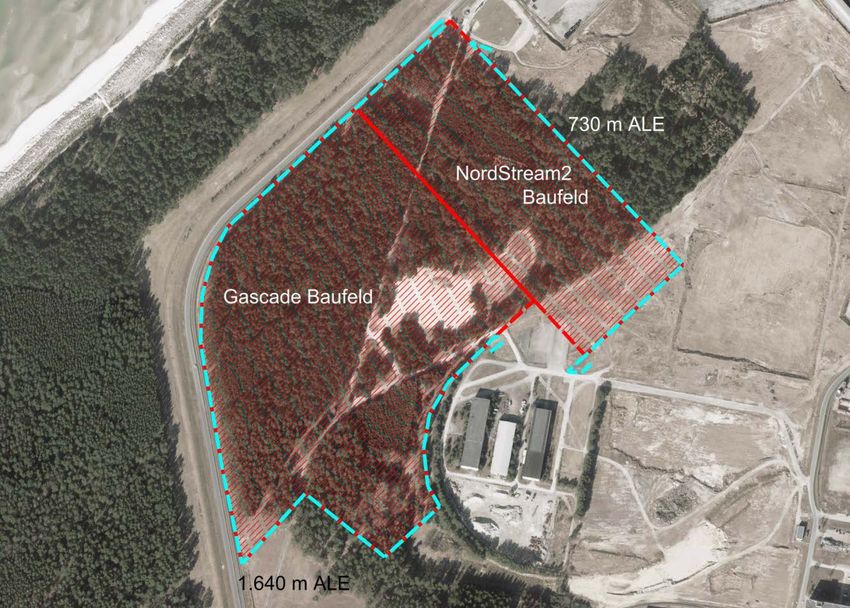
Page 4 of 48

S2         Protection and restoration of the topsoil
S3         Erection of a fence around the operation site of the pig receiving station and around the
           areas used during construction
S4         Construction-related shrub protective measures according to DIN 18920
M9         Building site clearance prior to the breeding season in order to prevent killing and injury of
           breeding birds
M 10       Survey of shrubs and trees at the building site regarding the occurrence of bats prior to
           the building site clearance
M 11       Reduction of light immissions during construction activities and operation
M 12       Reduction of noise emissions from onshore construction work during the breeding peri-
           ods of birds and bats
M 13       Access route from the parking area and office building to the construction site of the pig
           receiving station
 Species protection measures
CEF 1      Establish surrogate and evasion habitats for starlings
CEF 2      Create replacement sites for the soprano pipistrelle
 Design measures
G1         Implementation of the specifications of development plan no.1 Lubminer Heide Industrial
           and Commercial Park to plant trees for greenspace replacement of parking spaces

The ECS onshore within the Industrial and Commercial Park Lubminer Heide services serves
to implement/observe the relevant ancillary provisions under immission protection law, water
law and nature conservation law (plan approval decision dated 31.01.2018).

A.3.3           Immission control

A.3.3.1         The immissions emanating from the project developer's construction site may
                not contribute in a significant way to immission levels of the general adminis-
                trative regulation for protection against construction noise (AVV Baulärm)
                dated 19.08.1970 being exceeded at the key immission locations within the
                area of impact of the construction site during the construction phase (supple-
                ment to BAnz. No.160 dated 01.09.1970).

A.3.3.2         The provisions of the 32nd Regulation on the implementation of the Federal
                Immissions Control Act (BImSchV, equipment and machinery noise control
                regulation – 32 BImSchV) dated 29.8.2002 (BGBl. I p. 3478), last amended by
                Section 83 of the Regulation dated 31.08.2015 (BGBl. I p. 1474) are to be im-
                plemented.

A.3.3.3         The immissions emanating from the operation of the project developer's sys-
                tem may not contribute significantly to the immission levels of the general ad-
                ministrative regulation for the Federal Immissions Control Act (Technical in-
                structions for noise protection –TA Lärm) dated 26.08.1998 being exceeded at
                the key immission locations within the area of impact of the installation (GMBl
                No. 26/1998 p. 503).

A.3.3.4         When construction contracts are awarded, the contractor must be obliged by
                the project developer to observe existing noise protection regulations.

Nord Stream 2 Monitoring Strategy DE                   W-PE-EMO-PGE-SOW-800-MONITOEN-01        14.05.2018.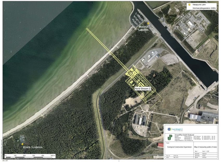
Page 5 of 48

A.3.3.5         Onshore traffic and service routes are to be asphalted taking into account
                foreseeable traffic loads. Dust emissions caused by construction activities, ve-
                hicle movements and weather are to be avoided or minimised by means of
                suitable measures such as moistening, cleaning and attachment.

A.3.3.6         In the course of construction activities, the immission levels set out in the
                Noise Assessment dated 21.12.2016 (cf. application document, Part I2.06,
                Part I2.07) are to be implemented and noise protection measures are to be
                verifiably applied where relevant. The following immission levels may not be
                exceeded at the relevant immission locations:
                Industrial areas                      day/night 70 dB(A)
                Commercial areas                      day 65 dB(A)
                                                      night 50 dB(A)
                Special area (Lubmin marina)          day 65 dB(A)
                                                      night 50 dB(A)
                General residential areas             day55 dB(A)
                (town of Lubmin)                      night 40 dB(A)
                Purely residential areas              day 50 dB(A)
                (town of Spandowerhagen)              night 35 dB(A)

A.3.3.7         Realisation of the noise reduction measures set out in the noise immissions
                forecasts are to be regularly inspected by a recognised body as part of the en-
                vironmental construction monitoring/ECS process. The inspection protocols
                are to be submitted to Stralsund Mining Authority.

A.3.3.8         In the course of construction activities, the levels are to be observed accord-
                ing to DIN 4150 Part 2 (Vibrations in construction; impact on people in build-
                ings – June 1999) and according to DIN 4150, Part 3, "Vibrations in construc-
                tion, impact on structural facilities") as defined by the Vibrations Assessment
                (cf. application document, Part I2.11), as required by the "Information on
                measurement, assessment and reduction of vibrational immissions" issued by
                the State Committee for Immissions Control (LAI; May 2000).

A.3.3.9         The lighting required for the construction and safe operation of the gas pipe-
                line is to be limited to the space and time required. Suitable anti-dazzle
                measures and the appropriate lighting are to be used so as to minimise luring
                effects on insects; spotlights are to be used in such a way that the max. up-
                ward tilt angle is 40°.

A.3.3.10        The emergency power diesel described in the application document (cf. appli-
                cation document, Part I1.04, Chapter 2.6) is to be operated as follows:
                The emergency power generation system may only be operated using extra-
                light heating oil with a max. sulphur content of 0.1 mass % of DIN 51603, Part
                1. Adherence to the sulphur content is to be confirmed by means of supplier
                confirmation.
                The emergency power generation system is to be set up and operated in such
                a way that the following emission limits are not exceeded in the exhaust emis-
                sions of the emergency diesel power units of the emissions sources:

Nord Stream 2 Monitoring Strategy DE                W-PE-EMO-PGE-SOW-800-MONITOEN-01     14.05.2018.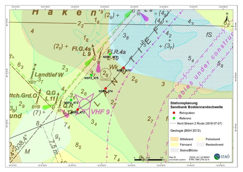
Page 6 of 48

                    • Dust 80 mg/m³
                    • Formaldehyde 60 mg/m³.
                The emission limits refer to the exhaust gas volume in normal state (tempera-
                ture 273,15 K, pressure 101.3 kPa) after deduction of the steam moisture con-
                tent and to a volume content of oxygen in the exhaust gas of 5%.
                Prior to putting the system into operation, a manufacturer declaration is to be
                submitted to the supervisory authority confirming that a power unit is being used
                which reliably adheres to the above emission levels.

A.3.6           Use of water

A.3.6.1         The start and finish of the construction measures (digging and dumping work,
                set-up of construction facilities, groundwater lowering, water discharge) are to
                be reported in writing to Stralsund Mining Authority and StALU Vorpommern
                as the responsible lower water authority in advance, at least two weeks be-
                forehand.

A.3.6.6         The required groundwater amounts are to be determined using suitable meas-
                urement devices and recorded. The project developer is to compile and coor-
                dinate a monitoring programme for groundwater observation with the lower
                water authority at least two weeks prior to the groundwater lowering. Before
                and during drainage operations, the groundwater levels are to be observed at
                the appropriate points (in the inflow and outflow area, for example) by means
                of groundwater measuring stations (gauges). The results of groundwater mon-
                itoring are to be submitted to the Stralsund Mining Authority and the lower wa-
                ter authority on request.

A.3.6.7         The planned drainage measures are to be carried out by appropriate special-
                ist companies according to the generally recognised technological regulations.
                The drainage measures are to be limited to the scope that is absolutely nec-
                essary for the project. The permit-holder is responsible for all damages in-
                curred as a result of the groundwater lowering or the drainage of the ground-
                water extracted.

A.3.6.8         In the area of the drainage, measures are to be taken to secure evidence on
                buildings and infrastructural facilities if the drawdown cone rises to their level
                and the owners request it.

A.3.6.9         Water use is subject to a fee. The chargeable party is to pay a fee for the
                withdrawal, extraction, channelling and drainage of groundwater according to
                Section 16 Paragraph 1 No. 2 LWaG (State Water Act). The lower water au-
                thority is to be informed of the actual volumes of water extracted (using the
                form issued by the State Office of the Environment, Nature Conservation and
                Geology M-WP "Declaration of Water Extraction Fee") by 31.01. of each year
                for the preceding year.

A.3.6.10        Insofar as contamination of the extracted ground water, bay water or pressure
                test water is discovered (e.g. visually or by smell), suitable cleaning measures
                are to be taken prior to drainage in trench 60, if necessary water use is to be
                discontinued. The Stralsund Mining Authority and the lower water authority
                are to be notified immediately. If the extracted groundwater is contaminated
                with suspended matter or sediment, mechanical cleaning must be carried out

Nord Stream 2 Monitoring Strategy DE                 W-PE-EMO-PGE-SOW-800-MONITOEN-01     14.05.2018.
Page 7 of 48

                prior to drainage into surface waters (e.g. ball filter, sedimentation tank) in or-
                der to minimise the sediment load. In order to avoid clogging, measures are to
                be applied as required such as the use of storage banks, aeration etc. The
                groundwater may not undergo any detrimental change prior to drainage.

A.3.8 Nature conservation

A.3.8.1         The nature conservation authority is to be informed of the start of construction
                implementation. In addition, the project developer is to inform the lower nature
                conservation authority of the district of Western Pomerania-Greifswald in good
                time of any schedule changes in relation to the onshore construction work.

A.3.8.2         The avoidance and mitigation measures named in the application documents
                are to be implemented (cf. application document, Part G.01, Chapter 9, p. 238
                ff.). …

A.3.8.6         An Environmental Construction Supervision (including pedological aspects) is
                to be commissioned for the project. The Environmental Construction Supervi-
                sion monitors and documents on site the proper implementation of avoidance
                and mitigation measures (cf. application document, Part G.01, Chapter 9) and
                other ancillary provisions under nature conservation law and is to be carried
                out by a trained specialist.
                The following objectives of the Environmental Construction Supervision are to
                be noted in particular:
                Secure and monitor conflict avoidance and mitigation measures-
                Implement the monitoring strategy
                …

                The Environmental Construction Supervision attends construction consulta-
                tions and provides instructions for employees regarding environmental and
                ecological aspects of construction implementation. In the event of deviations
                from environmental stipulations, these likewise have to be documented. The
                project developer is to inform the plan approval authorities immediately of any
                such deviations. The documentation of the Environmental Construction Su-
                pervision is to be submitted to the plan approval authority at least on a
                monthly basis or immediately on special request.

                The planning approval authority is to be informed of the contact partner for the
                Environmental Construction Supervision in good time in writing prior to the
                start of construction in each case. The authority for nature conservation is to
                be provided with a monthly status report on implementation and monitoring
                and a final report is to be submitted no later than six months after the end of
                each construction phase (onshore, offshore).

A.3.8.7         The construction time constraints under nature conservation law set out in the
                planning documents are to be observed (cf. application document, Part G.02).

A.3.8.15        While the work is being carried out as well as during the set-up and operation
                of the onshore construction site and storage sites, the provisions of DIN
                18920 (vegetation technology in landscaping – protection of trees, plantations
                and vegetations during construction work, 2002-08) are to be observed.

Nord Stream 2 Monitoring Strategy DE                 W-PE-EMO-PGE-SOW-800-MONITOEN-01     14.05.2018.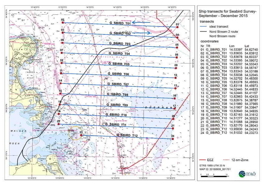
Page 8 of 48

A.3.8.16        As a supplement to the measure sheets M8 to M11 (cf. application document,
                Part G.02), light sources with a harmless colour spectrum (e.g. sodium vapour
                lamps) are to be used so as to minimise the light trap effect on insects, insofar
                as this is permitted under health and safety law.

A.3.8.17        The CEF measures 1 and 2 (Continuous Ecological Functionality measures;
                cf. application document, Part G.01) have to be applied and effective prior to
                the intervention. The functional capability of these CEF measures is to be en-
                sured during the entire sustenance period.

A.3.8.18        Completion of the CEF measures is to be reported. After completion of each
                measure, an official approval inspection must be carried out with the lower na-
                ture conservation authorities and the Stralsund Mining Authority.

A.3.8.19       In order to prevent nature protection legislation offences with regard to the
               moor frog, which is strictly protected under BArtSchV ("Bundesartenschutzge-
               setz" - Federal Special Protection Act) and Annex IV Habitats Directive, am-
               phibian protection fences are to be set up in the area of the pig receiving sta-
               tion. The amphibian protection fences are to be set up for the period of the be-
               ginning of March to the end of October. The Environmental Construction Su-
               pervision is to verify and continuously monitor the set-up of the amphibian
               protection fences and if necessary undertake adjustments of the amphibian
               protection fences, depending on the weather. The Environmental Construction
               Supervision is also to secure appropriate installation of catch buckets at all
               crossing points along the amphibian fences during the main migration periods
               from the beginning of March to the end of May and from the beginning of Au-
               gust to the end of October. Daily monitoring of the catch buckets in the early
               hours and the release of all frogs caught in the buckets outside the danger
               area is also to be carried out under the authority of the Environmental Con-
               struction Supervision.

A.3.8.20        The suspected winter hibernation site of the common noctule in the northern
                area of the pig receiving station as described (cf. application document, Part
                F.07, Chapter 5.1.3.2.4, p.79) is to be inspected for occupation prior to felling
                of the relevant tree. If occupation of the winter hibernation site with bats is dis-
                covered, the animals are to be appropriately resettled. If they cannot be reset-
                tled, the tree in question must be felled in segments. Segments which contain
                hibernation sites must be taken down carefully and moved to a new location,
                whereby the entrance to the hibernation sites is to be closed while the work is
                in progress. The loss of the verified hibernation tree is to be compensated for
                by the hanging of suitable boxes big enough to hold the common noctule in a
                1:7 ratio at a suitable distance from the construction area. The location of any
                necessary substitute hibernation sites is to be coordinated with the nature
                conservation authority.

A.3.8.21        The trenches and soil piles are to be created so that they cannot be settled by
                sand martins.

Nord Stream 2 Monitoring Strategy DE                 W-PE-EMO-PGE-SOW-800-MONITOEN-01      14.05.2018.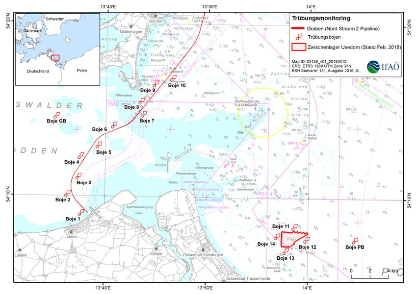
Page 9 of 48

2.1           S1, S2 – Protection of soil and groundwater
 During the basic surveys in 2017, two groundwater measuring stations were set-up and mon-
 itored in the area of the pig receiving station. In the course of construction preparation work
 (clearance, excavation, levelling), these measuring stations were removed and replaced in
 February 2018 and after completion of the clearance work by three new ones (Table 1, Fig.
 1). The position of the measuring stations during the construction phase was coordinated
 with the lower water authority in autumn 2017.

Table 1:          Coordinates (UTMS zone N 33 ETRS 89) of the measuring stations installed in Feb-
                  ruary/March 2018 for groundwater monitoring during construction
   Groundwater              Easting            Northing                      Location
    measuring
   GMS 1                    (411578)            6000704.6        Start trench – microtunnel outflow
   GMS 2                    (411541)            6000639.4        Start trench – microtunnel /
                                                                 construction trench anchor
                                                                 bl k
   GMS 3                     411606             6000599.5        Construction trench anchor blocks –
                                                                 outflow

                                                                                          Inflow point
                                                                                          Groundwater meas-
                                                                                          uring station
                                                                                          Pig receiving station

                       Groundwater
                       measuring station
                       Drainage basin

Fig. 1:           Groundwater measuring stations during the construction phase

 In the course of the ECS, the measuring results of the groundwater monitoring are to be
 checked regularly and compared to the registered extraction quantities. The drainage water

  Nord Stream 2 Monitoring Strategy DE                W-PE-EMO-PGE-SOW-800-MONITOEN-01        14.05.2018.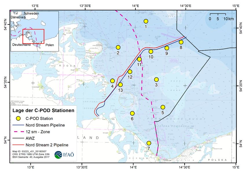
Page 10 of 48

 quality is likewise to be regularly monitored/documented. The same applies to the implemen-
 tation of/adherence to measures to avoid contamination of the soil and groundwater (ancil-
 lary provisions A 3.6 water use).
 The soil work (excavation, disposal, storage, level surfaces for the operating areas and thor-
 oughfares, topsoil installation) is likewise to be supervised and documented. Finally, the op-
 erating areas are to be measured and compared with the application. In the event of devia-
 tions, a subsequent assessment is carried out.

2.2           S3, S4, M13 – Construction fence, amphibian strand guide
 The building site clearance was carried out in February 2018, prior to the start of the migra-
 tion period of amphibians and the reproduction period of breeding birds and bats. After com-
 pletion of the preparatory clearance and soil work, a construction fence will be set up in
 March 2018 so as to protect the adjacent biotopes and shrubs. The construction fence will
 also be fitted with a privacy screen (where necessary). In order to protect migration amphib-
 ians, an amphibian strand guide will also be installed in March 2018 (after the frost period is
 over); this will include the construction sites of the pig receiving station (Nord Stream 2) and
 EST Lubmin 2 (Gascade) together (Fig. 2).
 The ECS will carry out regular inspections on the state of the protective facilities and super-
 vise the catch buckets of the amphibian strand guide in the area of the access routes during
 the migration periods.

                                                                                730 m amphibian
                                                                                protection facility

                                                            NordStream 2
                                                            construction area

                                     Gascade
                                   construction area

Fig. 2:           Course of the amphibian strand guide (ASG) in the area of the pig receiving station
                  (NSP2) and the EES (Gascade)

  Nord Stream 2 Monitoring Strategy DE                  W-PE-EMO-PGE-SOW-800-MONITOEN-01                 14.05.2018.
Page 11 of 48
2.3 M9, M11, M12 – Construction period limitations, reduction of noise and
light immissions to protect breeding birds and bats
In this regard, the ECS activities comprise the following:
• Documentation of construction sequence (keeping of an ecological construction di-
ary/compilation of construction protocols, compilation of photographic documentation,
preservation of evidence in the event of damage, monitoring of adherence to construc-
tion period regulations)
• Regular monitoring of the construction site in terms of the correct implementation of
measures and adherence to ancillary provisions
• Inspection of proper restoration of all areas used during the construction period
• Monitoring of environmental measures, compilation of protocols with details of the cor-
rective measures required in the event of complaints
This also includes monitoring of measures to reduce construction-related emissions serving
to protect breeding birds and bats. The varying degree of construction lighting, depending
on the work planned, is to be regularly monitored (height, shielding, orientation, type).
Noise measuring point
Pig receiving station
Fig. 3: Position of the permanent measuring stations for noise at the immission locations of
the town of Lubmin and Lubmin marina
At the immission locations of the town of Lubmin and Lubmin marina, permanent noise meas-
uring stations were set up in February 2018 by a recognised measurement expert (Bonk -
Nord Stream 2 Monitoring Strategy DE W-PE-EMO-PGE-SOW-800-MONITOEN-01 14.05.2018.Page 12 of 48
Maire - Hoppmann GbR) (Fig. 3). Occasional comparative measurements will be carried out
at the other immission locations (cf. Ancillary provision A.3.3.6). Based on the measurement
protocols, the ECS checks adherence to the ancillary provisions (A.3.3 Immission protection)
and measure M12 (during the reproduction period 01.04.-15.07. immissions drop below a
level of 47 dB(A) at a distance of approx. 100 m).
2.4 M10, CEF1 & 2 – Bat sites and nesting boxes for starlings
In summer 2017, three inspections were carried out in the forest at the pig receiving station
so as to determine habitat structures and potential bat hibernation sites. The first survey
involved a visual inspection of all trees. The second survey involved an examination of po-
tential habitat structures with an endoscope and telescope, before the third inspection was
carried out to check potential habitat structures using bat detectors. As a result, one hollow
tree was found in the entire clearance area which did not exclude potential use as a winter
hibernation site for the common noctule. Immediately prior to the start of the clearance work
in February 2018, all cavities were thus inspected by a bat expert once again for occupation.
The result of the inspection was negative. During the clearance work, the cavities were
opened and inspected once again. No bats were found (NSP2 ENVIRONMENTAL CONSTRUCTION
SUPERVISION – Onshore M10). After the clearance work had been completed, the two CEF
measures were implemented in February 2018. Bat sites and starling boxes were hung up
in the coastal protection woods. The position of the boxes was measured (Fig. 4). Implemen-
tation of measure M10 and CEF1&2 has been completed. Two separate reports were com-
piled for documentation purposes (NSP2 ENVIRONMENTAL CONSTRUCTION SUPERVISION – Onshore
CEF 1 and 2, incl. cartographic display in csv format or shp format).
Starling boxes (CEF 1)
Bat cavity – summer site (CEF 2)
Bat cavity – winter hibernation
site (CEF 2)
Fig. 4: Distribution of bat winter hibernation sites and nesting boxes in Lubmin coastal
woods.
Nord Stream 2 Monitoring Strategy DE W-PE-EMO-PGE-SOW-800-MONITOEN-01 14.05.2018.Page 13 of 48
3 Environmental Construction Supervision offshore, territorial waters M-WP
(2018/2019)
Nord Stream 2 has commissioned IMPaC Offshore Engineering GmbH to carry out the ECS
offshore. The work of the ECS offshore will be continuously documented. On a monthly ba-
sis, a status report will be compiled and submitted to Stralsund Mining Authority, StALU Vor-
pommern (State Office of Agriculture and the Environment of Mecklenburg-Western Pomer-
ania). If exceptional events occur, the authorities responsible are to be informed without de-
lay.
The ECS offshore in the M-WP territorial waters serves to implement/adhere to offshore
measures (application document G.02 – measure sheets).
Offshore measures
Minimisation of the area of intervention in hard soil biotopes within the Site of Commu-
M1
nity Interest (SCI)
M2 Minimisation of the area of intervention in soft soil biotopes within the Bay of Greifswald
Re-establishment of the seabed in trenched areas and at the interim marine storage
M3
facility
Reduction of turbidity plumes due to the deployment of mechanical dredgers within the
M4
FFH areas
Compliance with turbidity limits of 50 mg/l at a distance of 500 m from the source of the
suspension, whereby in the short term up to 100 mg/l in addition to the background
M5
suspension could be possible within SCI in coastal waters of M-WP as well as in the
interim marine storage facility.
M6 Construction time constraints from the middle of May until the end of December in the
Bay of Greifswald and in the south-west of the Bay of Pomerania
M7 Construction time constraints in the Bay of Pomerania from KP 53
M8 Reduction of light immissions during offshore construction activities.
The ECS offshore in the M-WP territorial waters serves to implement/adhere to the relevant
ancillary provisions under immissions protection law, water law and nature conservation law
(plan approval decision dated 31.01.2018).
A.3.3.6 In the course of construction activities, the immission levels set out in the Noise
Assessment dated 21.12.2016 (cf. application document, Part I2.06, Part I2.07)
are to be implemented and noise protection measures verifiably applied where
relevant. The following immission levels may not be exceeded at the relevant
immission locations:
Industrial areas day/night 70 dB(A)
Commercial areas day 65 dB(A)
night 50 dB(A)
Special area (Lubmin marina) day 65 dB(A)
night 50 dB(A)
General residential areas day55 dB(A)
(town of Lubmin) night 40 dB(A)
Purely residential areas day 50 dB(A)
(town of Spandowerhagen) night 35 dB(A)
Nord Stream 2 Monitoring Strategy DE W-PE-EMO-PGE-SOW-800-MONITOEN-01 14.05.2018.Page 14 of 48
During night time with the addition of the day times with increased sensitivity
(8:00 pm to 7:00 am), the backhoe dredger and pipe-laying barge are to ob-
serve the following minimum distances as defined by the offshore construction
noise study (volume of materials I2.06):
• from the nearest point on the coastline in the area of Lubmin
- backhoe dredger without convoy: 4,000 m
- pipe-laying barge without convoy: 1,500 m
- together with convoy – backhoe dredger: 4,600 m and pipe-laying barge:
2,600 m
• from the nearest point on the coastline in the area of Rügen/Thiessow
- with convoy – backhoe dredger: 3,100 m and pipe-laying barge: on pipe-
line line
It is admissible to move in closer than these distances if the levels specified in
the construction survey (cf. application document, Part I2.06, Tab. 5) are guar-
anteed by the manufacturer of the item of equipment in question and evidence
of this is submitted in advance to Stralsund Mining Authority by means of the
relevant manufacturer confirmation.
A.3.3.7 Implementation of the noise reduction measures set out in the noise immissions
forecasts is to be regularly inspected by a recognised body as part of the envi-
ronmental construction monitoring/ECS process. The inspection protocols are
to be submitted to the Stralsund Mining Authority.
A.3.6.2 Care is to be taken to ensure that only pollutant-free and largely non-organic
excavation material is taken to the interim marine storage facility (tipping area),
which can be stored there in line with the "Joint transitional provisions for han-
dling dredged material in coastal waters" (GÜBAK, Aug. 2009). Insofar as re-
sidual munitions are concerned, the project developer will ensure that only ma-
terial is taken to the interim storage facility which does not contain munitions
remains larger than a modelled magnetisable metal mass of 15 kg per object.
Excavation material with an organic content of >3%, cohesive soil (cohesive
till, clay) and excavation material with pollutant content which exceeds the
benchmark (BM) 2 as defined by GÜBAK, Aug. 2009 may not be taken to the
interim marine storage facility and placed in interim storage there.
A.3.8.2 The avoidance and mitigation measures named in the application documents
are be implemented (cf. application document, Part G.01, Chapter 9, pp. 238
ff.). In addition to the avoidance and mitigation measures, care must be taken
to ensure that bird habitats (e.g. moulting and staging sites) are avoided in the
choice of access routes to the construction area, use of the water is reduced to
what is absolutely necessary in terms of time and space and sediment transport
and turbidity plumes are minimised by using the appropriate techniques.
A.3.8.3 All construction traffic is to use shipping routes marked on the nautical maps
as far as possible and keep the distances from the shipping routes to the con-
struction site or interim storage facility as short as possible. Prior to the start of
construction, Stralsund Waterways and Shipping Office and Stralsund Mining
Authority are to be provided with a logistics plan showing that this requirement
has been taken into account, with a justification of the cases in which use of
Nord Stream 2 Monitoring Strategy DE W-PE-EMO-PGE-SOW-800-MONITOEN-01 14.05.2018.Page 15 of 48
the shipping routes or a direct path from the shipping route to the construction
site/interim storage facility cannot be chosen.
A.3.8.6 An Environmental Construction Supervision (including pedological aspects) is
to be commissioned for the project. The Environmental Construction Supervi-
sion monitors and documents the proper implementation of avoidance and mit-
igation measures on site (cf. application document, Part G.01, Chapter 9) and
other ancillary provisions under nature conservation law and is to be carried
out by a trained specialist. The following objectives of the Environmental Con-
struction Supervision are to be noted in particular:
• Secure and monitor conflict avoidance and mitigation measures-
• Implement the monitoring strategy
• Comply with target maximum turbidity levels, separation of the different
substrates during dredging according to the approved measures M4/M5
(cf. application document, Part G.02), monitoring of the restoration of the
biotope structure in the vicinity of the pipe trench
• Separate excavation soil for interim storage at the marine interim storage
facility (tipping site)
• Avoid bird habitats (e.g. moulting and staging sites) in the choice of access
routes to the construction site
• Reduce the use of the water to what is absolutely necessary in terms of
time and space
• Ensure that sediment transport and turbidity plumes are minimised by the
use of appropriate techniques.
A.3.8.7 The construction time constraints under nature conservation law set out in the
planning documents are to be observed (cf. application document, Part G.02).
3.1 M 1/M 2/M 3 Dredging strategy
The excavation and filling of the pipe trench incl. restoration of the marine biotopes are to be
carried out based on a detailed dredging strategy. The dredging strategy covers the follow-
ing:
• Quantification of soil types of the pipe trenches based on geotechnical surveys (block
models for pipe trenches and interim storage facilities)
• Technical plan for the dredging and restoration work (taking into account the minimi-
sation of the intervention areas and turbidities)
• The construction schedules
• The volume analysis plan (Fig. 5)
The use and restoration of the tipping site, the transport of excavation material which is un-
suitable for filling the pipeline trench to Mukran harbour for the purpose of constructing a
passenger terminal at the northern pier and the import of embedding material for the pipe-
lines form part of the dredging strategy.
AIS and data loggers are to be used for continuous tracking of the offshore construction fleet.
Various data that allow the origin of the content of each barge to be identified and also the
location of the interim storage of the material at the tipping site will be recorded and saved.
Nord Stream 2 Monitoring Strategy DE W-PE-EMO-PGE-SOW-800-MONITOEN-01 14.05.2018.Page 16 of 48 The repeated measurement of pipeline trenches and the interim storage facility ensure pre- cise execution of the dredging work and enable monitoring of the defined tolerances for dredging work and restoration. The task of the Environmental Construction Supervision is to monitor execution of the con- struction work in relation to the environmental requirements based on daily reports, real-time data regarding shipping and geophysical measurement data. Fig. 5: Volume analysis plan of the dredging strategy 3.2 M 4/M 5 Turbidity monitoring Adherence to the stipulated turbidity limits in the area of the Bay of Greifswald and the Bod- denrandschwelle bay threshold is ensured by means of automatic sensors (Annex 1). Along the pipeline trench to be dredged, turbidity sensors (optical backscatter sensors) will be in- stalled on buoys for the duration of the offshore work on both sides of the pipeline route at intervals of 500 m. Four additional sensors will be installed in the area of the tipping site at intervals of 500 m (for the location of the measurement stations, see Fig. 6 and Tab. 2). At reference stations (one in the Bay of Greifswald, one in the Bay of Pomerania), ADCPs and wave height meters will also be used at a distance of 5 km from the construction activi- ties (to determine natural background turbidity). On the seabed, additional oceanographic parameters will be recorded continuously (oxygen content, Chl-a concentration, salt content, temperature). This information will facilitate the interpretation of the turbidity levels while at the same time providing the main basis for monitoring resettlement of the benthic biotopes. The positions of the measurement buoys will be coordinated with the GDWS (General Di- rectorate for Waterways and Shipping) in order not to endanger the safety and ease of ship- ping. Turbidity measurement figures will be measured continuously and transmitted by radio to a monitoring centre in Lubmin construction office (Fig. 7). All sensors will be regularly cali- brated and serviced during use. The measurement buoys will be installed in March 2018 and Nord Stream 2 Monitoring Strategy DE W-PE-EMO-PGE-SOW-800-MONITOEN-01 14.05.2018.
Page 17 of 48

 put into operation four weeks prior to the start of construction (mid-April) in order to document
 the initial condition before construction starts.

                                                                               Trench (Nord Stream 2 pipeline)
                                                                               Turbidity buoys
                                                                               Usedom interim storage facility
                                                                               (status: Feb. 2018)

Fig. 6:           Location of the measurement stations for turbidity monitoring in the vicinity of the
                  pipe trench and the soil tipping area.

Table 2:          Turbidity monitoring stations in the Bay of Greifswald (WGS84)
     Buoy                        Latitude              Longitude                 Water depth (m)
     Reference buoy GB           54;14;36.49580 N      13;35;06.85448 E               5.7
     Reference buoy PB           54;07;37.86712 N      14;04;37.69086 E              11.9
     Buoy 1                      54;09;02.13927 N      13;37;41.94187 E               5.5
     Buoy 2                      54;10;06.27606 N      13;36;19.08046 E               7.8
     Buoy 3                      54;11;07.51406 N      13;37;22.07781 E               7.9
     Buoy 4                      54;12;18.96758 N      13;37;32.96297 E               6.7
     Buoy 5                      54;12;56.85040 N      13;39;18.66899 E               5.5
     Buoy 6                      54;14;06.72043 N      13;40;47.62477 E               7.5
     Buoy 7                      54;14;45.83780 N      13;43;40.82775 E               5.1
     Buoy 8                      54;15;31.84494 N      13;43;26.59443 E               5.7
     Buoy 9                      54;16;32.12513 N      13;44;49.34022 E               9.3
     Buoy 10                     54;16;52.50259 N      13;46;31.71231 E               8.5
     Buoy 11                     54;08;23.31875 N      13;58;40.37453 E              11.9
     Buoy 12                     54;07;38.61700 N      14;00;31.33522 E              13.6
     Buoy 13                     54;06;54.09649 N      13;58;47.13576 E              12.7
     Buoy 14                     54;07;41.14970 N      13;56;52.92691 E              10.0
     Buoy Tide                   54;27;20.87618 N      13;58;27.14641 E              15.5

  Nord Stream 2 Monitoring Strategy DE                   W-PE-EMO-PGE-SOW-800-MONITOEN-01                   14.05.2018.
Page 18 of 48
Fig. 7: Measuring strategy for turbidity monitoring
Even when turbidity approaches the set limits (see mitigation measure M5: adherence to
turbidity limits, plan approval decision p. 217), measures to reduce sediment suspension can
be taken immediately. The effectiveness of such measures can also be monitored. If the
warning or alarm level is reached, various mitigation measures can be taken:
• Adapt dredging work depending on current and wind
• Reduce overflow in connection with trailing suction hopper dredgers
• Adapt flush speed during backfilling
• Use an apron during backfilling
The dredging company is responsible for the proper operation of the turbidity buoys and the
monitoring system. The decision regarding any measures to be adopted is taken by the
dredging company in coordination with Nord Stream 2 (Fig. 8). The tasks of the Environmen-
tal Construction Supervision are to verify the quality of monitoring of the figures from the
ongoing turbidity and calibration measurements on a daily basis and to document limit over-
runs and mitigation measures adopted.
Nord Stream 2 Monitoring Strategy DE W-PE-EMO-PGE-SOW-800-MONITOEN-01 14.05.2018.Page 19 of 48
Project work Web-based access –
Marine operations stakeholders
Continuous moni-
toring of permanent
buoy stations Web-based access –
Nord Stream 2
Online data
Automatic data processing in-
presenta- Data
cluding quality control
tion storage
Automatic data results analysis
Project management notified
Turbidity levels are checked
against threshold levels
Check at hierarchized management level
Warning level (2) Alarm level (3)
Notification (text mes-
sage/mail)
Interpretation of field data
sets
Cause-effect assessment
Determination of source
Nord Stream 2 notified
Source in project work?
Monitoring reports
Implementation of (adapted) pro-
ject management
Suitable mitigation measures
Compliance validation
Check assessment of con-
trol measures
Fig. 8: Management strategy of the dredging company for turbidity monitoring
Nord Stream 2 Monitoring Strategy DE W-PE-EMO-PGE-SOW-800-MONITOEN-01 14.05.2018.Page 20 of 48
3.3 Traffic monitoring
During the 2018 construction phase there will be up to 50 vessels operating in the German
maritime area at the same time in some cases. For execution of the construction work, a
detailed construction sequence schedule will be submitted to the GDWS for coordination
according to ancillary provision A 3.1.3. This will be regularly updated to reflect construction
progress.
The vessels will use routes which have likewise been agreed on in advance with the GDWS.
The routes serve the following purposes:
• Ensure safety and ease of shipping
• Avoid conflicts with fishery
• Avoid disruptive effects vis-à-vis marine mammals and staging birds
• Avoid impairing cultural assets
Monitoring of the individual vehicles of the construction fleets will be carried out using AIS
and also by means of additional data loggers. These will record the position and also the
following parameters, among others:
• Direction of travel
• Speed
• Operating state in the case of dredgers and barges (loading/dumping)
Tromper Wiek II storage site
(embedding material)
Mukran limestone facility
(Deposit of marl and sand with
organic content >3%)
Usedom interim storage facility
Fig. 9: Route plan
Nord Stream 2 Monitoring Strategy DE W-PE-EMO-PGE-SOW-800-MONITOEN-01 14.05.2018.Page 21 of 48
A Marine Coordination Centre (MCC) will be set up in Lubmin to continuously monitor traffic.
This centre will be permanently staffed during the construction period and will be in constant
contact with the shipping authority responsible.
The task of the Environmental Construction Supervision is to ensure daily verification of ad-
herence to ancillary provisions A.3.8.2 (avoidance of disruptive effects in the area of staging
areas and seal resting sites), A.3.8.3 (clustering and minimisation of traffic) and A.3.8.7 (ad-
herence to construction timeframes).
The traffic data collected will also be considered in analysing data on seabirds and marine
mammals as well as underwater sound measurements.
4 Environmental Construction Supervision offshore, continental shelf
(2018/2019)
The tasks of the Environmental Construction Supervision are limited to traffic monitoring and
adherence to construction period limitations.
Nord Stream 2 Monitoring Strategy DE W-PE-EMO-PGE-SOW-800-MONITOEN-01 14.05.2018.Page 22 of 48
5 Construction monitoring
During construction work, possible disruptive effects on staging seabirds and marine mam-
mals will be recorded. For this purpose, firstly emissions that are the source of these relevant
disruptive effects will be documented and secondly the occurrence and distribution of animal
species will be analysed. The disruptive effects of the project in relation to seabirds and
marine mammals include the following:
• Turbidity plumes (see Section 3.2)
• Shipping (see Section 3.3)
• Underwater noise emissions (see Section 5.1)
5.1 Underwater noise measurements
During the construction of the Nord Stream 2 pipeline in the Bay of Pomerania, underwater
noise immissions will be measured in order to be able to assess the intensity of the construc-
tion-related impairment caused to marine mammals as a result of construction noise in the
region. The following sources of sound will be taken into consideration (Fig. 2 and Tab. 2):
Bay of Pomerania, 12 nautical mile zone
Emissions during the dredging of the pipeline trenches north of the former Oder bed, laying
of the pipeline and during backfilling in the Bay of Pomerania
The pipe-laying work in the Bay of Pomerania will be carried out from September to Decem-
ber 2018. Sound emissions from offshore construction work will be registered in the area of
the northern end of the trench (Tab. 3, Fig. 10). For this purpose, a measuring station will be
set up at a distance of 1,000 m from the construction area. The location of the station will
depend on the shipping in this maritime area and will be coordinated with the GDWS.
In the Bay of Greifswald and in the area of the Boddenrandschwelle bay threshold, the same
construction vehicles or identical models will be used as for the construction of the Nord
Stream pipeline, which underwent extensive underwater noise monitoring in 2010 (four
measurement stations, NSP1 MONITORING UNDERWATER NOISE IMMISSIONS 2010).
Emissions and immissions data is available for 40 vessels. These measurements will not be
repeated, since no new insights are to be anticipated.
Bay of Pomerania, EEZ
Emissions during the laying of the pipeline in the Bay of Pomerania north of Oderbank
In the area of the continental shelf, the sound emissions caused by pipe-laying work in the
area of KP 16,5 will be documented since various construction activities will be carried out
here (pipe-laying using a pipe-laying vessel of the third generation, pipe-laying with a pipe-
laying vessel of the fourth generation, AWTI and securing by means of rock placement). For
this purpose, a measuring station will be set up at a distance of 1,000 m from the construction
area (Tab. 3, Fig. 10). This station is to be operated during construction work in the years
2018 and 2019 (several measuring periods). The location of the station will depend on the
shipping in this maritime area and will be coordinated with the GDWS.
Nord Stream 2 Monitoring Strategy DE W-PE-EMO-PGE-SOW-800-MONITOEN-01 14.05.2018.Page 23 of 48
Underwater noise station
12 nautical mile zone
Cable
in trench
surface-laid
kilometre point
Fig. 10: Position of the measurement stations for underwater noise immissions
Tab. 3: Stations for measuring underwater noise emissions.
Sta- Eastern longi- Lat (DecDegr) Lon (DecDegs) Water depth (m)
tion tude Northern latitude
1 14° 01' 14.650" 54° 28' 50.057" (54.480571) (14.020736) 18
2 14° 15' 29.791" 54° 32' 54.315" (54.548421) (14.258275) 19
The measuring technology and method follow the "Regulations for underwater noise meas-
urements in offshore wind farms" issued by the Federal Maritime and Hydrographic Agency
(BSH, www.bsh.de), insofar as these are applicable/appropriate (during the laying of pipe-
lines, no impulse sound is emitted, due to the use of anchors for positioning of the pipe-laying
vessel, a minimum distance of 1,000 m from the pipeline route is to be observed in carrying
out the measurements).
Nord Stream 2 Monitoring Strategy DE W-PE-EMO-PGE-SOW-800-MONITOEN-01 14.05.2018.Page 24 of 48
5.2 Staging birds
Bay of Pomerania maritime area (12 nautical mile zone and continental shelf (EEZ))
Registration by means of digital aerial photographs
Seabird registrations by means of digital flight photos will be carried out during the construc-
tion phase in the Bay of Pomerania on three occasions in autumn 2018 along each of four
transects above and parallel to the Nord Stream 2 pipeline. The transects cover the entire
pipeline corridor from the intersection area with the former Oder bed at KP 51 to KP 17 in
the EEZ (AWTI installation point). One transect runs directly over the route of the Nord
Stream 2 pipeline. Two other transects run at a distance of approx. 2 km and 3 km to the
south and one at a distance of approx. 2 km to the north of the Nord Stream pipeline (Fig.
11).
The aerial photographs will be georeferenced for analysis purposes. All items found will then
be marked manually and stored in a database with the geographical position. For the pur-
pose of quality control of this screening (image analysis, preliminary sorting of items), at least
10% of the visual material is to be viewed by a second observer in line with BSH require-
ments. Species will then be determined and quantified. At least two experts are to carry out
species determination of the registered birds and marine mammals independently.
Flight transect
EEZ
12 nautical mile boundary
in trench
surface-laid
Fig. 11: Position of the flight transects to register seabirds by means of digital aerial photographs
(construction phase).
Nord Stream 2 Monitoring Strategy DE W-PE-EMO-PGE-SOW-800-MONITOEN-01 14.05.2018.Page 25 of 48
5.3 Harbour porpoises
Bay of Pomerania maritime area (12 nautical mile zone and continental shelf (EEZ))
Registration by means of C-PODs
From 30.06.2010 to 12.12.2013, 13 C-PODs were positioned in the Bay of Pomerania. Po-
sitions 8 to 13 were installed along the Nord Stream 1 pipeline, spaced at intervals of approx.
1.3 km. From 2010 to 2012, one T-POD was positioned in addition to the C-POD at positions
1 to 7 (NSP1 MONITORING HARBOUR PORPOISES 2013). The synchronous installation
of C-PODs (current equipment type) and T-PODs (1st generation equipment type prior to
2008) aimed to enable a long-term trend analysis for the Bay of Pomerania maritime area by
means of calibration between the two equipment types, taking into account the data of DMM
Stralsund from the period 2004-2008.
In terms of the monitoring programme for Nord Stream 2, only C-PODS will be used at the
identical 13 stations (Fig. 12). The distance of sensors 8-13 will therefore be approx. 2.3 km
from the Nord Stream 2 pipeline route. The measurement programme will be carried out
during the construction phase for the Nord Stream 2 project in the Bay of Pomerania from
July 2018 to December 2019, as well as in the subsequent year 2020. The use of the identical
station network will allow subsequent implementation of a trend analysis (2010-2020, seven
years of measurement), if the equipment settings and the data analysis procedure are iden-
tical. This is why the stations in the area of the Nord Stream pipeline are to be maintained.
Since C-PODs are not able to register small-scale avoidance behaviour (NSP1 MONITOR-
ING HARBOUR PORPOISES 2013), greater importance is attached to the constancy of the
measuring network than to the distance from the construction activity in terms of data inter-
pretation. The detection range of C-PODs for harbour porpoises is 200-300 m. What is more,
the occurrence of harbour porpoises in the Bay of Pomerania is still very rare. In four years
of Nord Stream 1 monitoring, it was never possible to register harbour porpoise clicks which
were synchronised with a shipping passage at the same measurement station.
Table 4 indicates the position of the C-POD stations. The position of the stations can also be
seen in the following Fig. 12.
Table 4: Geographical coordinates (WGS 84) of the C-POD stations
C-POD station Eastern longi-
Northern latitude Water depth (m)
tude
1 14° 06' 19.140 54° 42' 09.900 26
2 13° 49' 59.220 54° 32' 59.160 21
3 14° 12' 59.040 54° 22' 03.060 13
4 13° 47' 00.360 54° 21' 23.280 15
5 14° 16' 58.140 54° 12' 28.860 14
6 13° 58' 59.400 54° 10' 14.700 10
7 14° 08' 58.500 54° 00' 00.000 10
8 14° 27' 25.080 54° 35' 04.560 23
9 14° 18' 56.606 54° 32' 59.106" 23
10 14° 09' 28.380 54° 31' 43.200 18
11 14° 02' 41.815" 54° 28' 59.750 18
12 13° 57' 13.320 54° 24' 38.280 13
13 13° 51' 41.700 54° 20' 04.140 18
Nord Stream 2 Monitoring Strategy DE W-PE-EMO-PGE-SOW-800-MONITOEN-01 14.05.2018.Page 26 of 48
Location of C-POD stations
Figure 12: C-POD positions
5.4 Grey seals
Bay of Greifswald maritime area (12 nautical mile zone)
Counts of resting places
From April 2018 to April 2019, monthly counts of grey seals will be carried out at the three
main resting places in the area of the Bay of Greifswald (Großer Stubber, island of Ruden,
Greifswalder Oie) (cf. Fig. 13). The counts will be carried out in ideal weather conditions
(wind force < Bft. 3; visibility range > 6 nautical miles (no fog); southerly wind direction and
swell < 0.5 m). The observations will be made by two observers with binoculars (magnifica-
tion 10x52 and 7x50) and spotting scope (30x80) as well as by manual GPS. The age (young
animal, adult) and gender will be determined if possible. If more than five animals are ob-
served at a resting place, the turnover is tracked during the course of one hour of observation
(number of animals is counted at least every ten minutes, other changes in number and
composition are also documented). At Großer Stubber, visual registration will be carried out
from a boat anchored in the immediate vicinity of the shallows. On Ruden it is possible to
use the former measurement tower (20 m high) from which the more remotely situated stone
wall areas of the breakwaters can be viewed. On the Greifswalder Oie, registration will be
carried out from land at seven defined observation points (cf. Fig. 13), from which the pre-
ferred resting places on the Greifswalder Oie can be scanned. At each observation point,
the seals present will be observed for 10-15 minutes. Identical synchronous counts were
previously carried out during the basic surveys in 2015-2016 (NSP 2 application documents,
I1.03 - NSP 2 - data basis and survey methods).
Nord Stream 2 Monitoring Strategy DE W-PE-EMO-PGE-SOW-800-MONITOEN-01 14.05.2018.You can also read