Draft Whangamata Catchment Management Plan - Environment Waikato Internal Series 2007/13
←
→
Page content transcription
If your browser does not render page correctly, please read the page content below
Environment Waikato Internal Series 2007/13

Draft
Whangamata
Catchment Management Plan

www.ew.govt.nz
Prepared by:
Julie Beaufill

For:
Environment Waikato
PO Box 4010
HAMILTON EAST

21 November 2006

Document #: 1194680
Contents
1     Introduction                                                                        1
    1.1   Vision                                                                           1
    1.2   Objectives and outcomes                                                          2

2     Background                                                                          2
    2.1   The Peninsula Project                                                            2
    2.2   An integrated approach                                                           2
    2.3   Community process                                                                3

3     Legislative and planning framework                                                  3
    3.1   Soil Conservation and Rivers Control Act (1941)                                  3
    3.2   Resource Management Act (1991)                                                   4
    3.3   Regional Policy Statement                                                        4
    3.4   Waikato Regional Plan                                                            4

4     Catchment description                                                               5
    4.1   Location                                                                         5
    4.2   Physical characteristics                                                         5
     4.2.1   Geological                                                              5
     4.2.2   Land use                                                                6
    4.3   Social                                                                           7
     4.3.1   The Coromandel Peninsula Blueprint Project                              7
    4.4   Tangata whenua                                                                   7
    4.5   Ecological                                                                       8
    4.6   Key stakeholders                                                                 8

5     Catchment assessment                                                                11
    5.1   Values                                                                          11
    5.2   Key issues                                                                      11
    5.3   Wentworth River                                                                 12
     5.3.1   Lower reach (from the causeway upstream to old quarry)                13
     5.3.2   Mid section (old quarry to approximately 1.5 kilometres upstream)     14
     5.3.3   Upper reach (to the ford)                                             14
     5.3.4   Tributaries                                                           15
    5.4   Waikiekie                                                                       16
     5.4.1   Lower reach (below state highway bridge)                              16
     5.4.2   Middle reach (above state highway to tributary confluence)            16
     5.4.3   Mid reach to forestry boundary                                        16
    5.5   Te Weiti                                                                        17
     5.5.1   Lower reach (below the state highway)                                 17
     5.5.2   Upper reach (above the state highway)                                 17
     5.5.3   Tributary                                                             18
    5.6   Otuwhete Stream/Julian Drive                                                    18

6     Methods and outcomes                                                                18
    6.1   Land management protection                                                      18
     6.1.1   Methods                                                               18
     6.1.2   Benefits                                                              19
    6.2   Riparian enhancement                                                            19
     6.2.1   Methods                                                               19
     6.2.2   Benefits                                                              19
     6.2.3   Outcomes                                                              20
    6.3   River and flood management                                                      20
     6.3.1   Methods                                                               20

Doc # 1194680                         DRAFT DOCUMENT                             Page i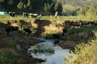
6.3.2 Benefits 20
6.3.3 Outcomes 20
7 Implementation 21
7.1 Community process 21
7.2 Work programme 22
8 Costs 22
9 Funding 23
10 Monitoring and reporting 24
Appendix 1 Assessment of individual streams 25
Appendix 2 List of recommended native plants 33
Figures
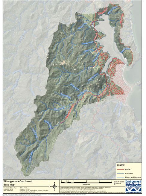
Figure 1 Location of Whangamata catchment 5
Figure 2 Land use in Whangamata catchment 9
Figure 3 Aerial view of Whangamata catchment 10
Figure 4 Cattle next to the Wentworth River 12
Figure 5 Blockage in Wentworth River channel 14
Figure 6 Slumping of the riverbank and stock access 15
Figure 7 Planting on coastal margin of Te Weiti Stream 17
Figure 8 Setting a rat trap 19
Figure 9 Stream bank erosion in the Wentworth River 21
Tables
Table 1 Soil classification – Whangamata catchment 6
Table 2 Land management protection 22
Table 3 Riparian enhancement 23
Table 4 River and flood management 22
Table 5 Survey and design costs 23
Table 6 Total cost – tables 2-5 23
Page ii DRAFT DOCUMENT Doc #1194680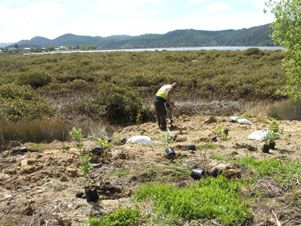
1   Introduction
    The Whangamata catchment sits on the lower east coast of the Coromandel Peninsula.
    The catchment supports a range of activities including multiple land use, pastoral and
    forestry activities and hosts a small sea-side community. The catchment’s diversity and
    the value many people place on this area create a situation where there are a number
    of pressures and conflicts of interest.

    In 2006-7, a Draft Whangamata Harbour Management Plan was developed with
    community groups and agencies in an attempt to identify and address some of the
    issues around the harbour - particularly in terms of managing increasing sediment
    levels and mangrove expansion.

    A key component of the harbour plan was the identification of the need for a catchment
    management plan. This recognised the importance of taking a ‘whole of catchment’
    approach to sedimentation issues and other issues such as biodiversity protection,1
    flood management and riparian protection to enhance water quality.

    The intention of the Draft Whangamata Catchment Management Plan is to provide an
    assessment of the river and catchment issues in the Whangamata catchment and an
    implementation strategy for the works it needs. At this stage it is intended to be a guide
    only and a detailed works plan will be finalised once discussion has been carried out
    with land owners within the catchment. The catchment management plan will
    complement targets set out in the harbour plan.

    This catchment management plan should also be read in conjunction with the two other
    key documents related to managing issues in Whangamata Harbour and its catchment:
    the Draft Whangamata Harbour Plan 20072 and the Whangamata Mangrove
    Management Options Report.3

    1.1 Vision
    A stable and healthy catchment supported by the community, land owners and iwi with:

    x   reduced erosion
    x   improved water quality
    x   enhanced biodiversity
    x   reduced sedimentation of the harbour and estuary
    x   reduced flooding.

    This will support the vision of the Whangamata Harbour Plan which is:

    Agencies, community and Mãori working together on actions and physical works that
    identify, enhance and restore cultural, recreational, ecological and visual values of the
    harbour.

    1
      Biodiversity a term used to describe the variety of plants and animals living in an area.
    2
      Environment Waikato. 2007: Draft Whangamata Harbour Plan. Environment Waikato Internal Series 2007/14,
        Environment Waikato, Hamilton. Available online at www.ew.govt.nz/projects/iwhangamata/index.htm.
    3
      Environment Waikato. 2007: Draft Whangamata Mangrove Management Options Report. Environment Waikato
        Internal Series 2007/15, Environment Waikato, Hamilton. Available online at
        www.ew.govt.nz/projects/iwhangamata/index.htm.

    Doc # 1194680                               DRAFT DOCUMENT                                            Page 1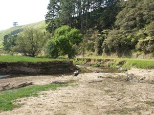
1.2 Objectives and outcomes
    Key objectives are to:

    x       provide an integrated approach to river and catchment management
    x       provide a guide for improving the stability of the catchment and the health of the
            environment
    x       promote ‘best practice’ techniques while ensuring social, economic, cultural and
            environmental well-being
    x       work with and encourage the participation of tangata whenua, interest groups and
            the residents and ratepayers of the Whangamata area.

    Key outcomes of the plan will be:

    x       reduced sediment and nutrient input into waterways
    x       improved water quality and biodiversity
    x       improved flood management
    x       identification of appropriate measures for works and restoration
    x       integration of existing works and initiatives
    x       links between groups and organisations in the catchment.

2   Background
    2.1 The Peninsula Project
    The Coromandel Peninsula is known for its beautiful environment. However, river bank
    erosion, debris blocking rivers and streams, the effect of animal pests on forest health
    and storms have caused widespread problems for communities.

    The Peninsula Project aims to improve these issues. It is a collaborative project
    between Environment Waikato, Thames Coromandel District Council, the Department
    of Conservation and Hauraki Mãori Trust Board established in 2004.
    http://www.ew.govt.nz/regionalservices/rivercatchment/peninsula/peninsulapopup.htm
    Over the next 20 years, the project will have far-reaching benefits for both the
    environment and the people who live and holiday on the peninsula. It will:

    x       better protect people, property and essential services from flooding
    x       reduce sedimentation in rivers, harbours and estuaries
    x       improve water quality
    x       reduce pests such as possums and goats
    x       improve the diversity of flora and fauna
    x       improve and stabilise catchments
    x       sustain the mauri4 of the peninsula from the mountain ranges to the sea.

    The Draft Whangamata Catchment Management Plan will be implemented
    predominantly through the Peninsula Project.

    2.2 An integrated approach
    ‘Catchment management’ has become a catch phrase in recent years, with agencies
    and communities keen to take a holistic approach to issues and to get involved in work
    to improve their area. The premise is that there is a need to be aware of the
    implications land use actions have, upstream, downstream and in the surrounding
    catchment.

    4
        ‘Life force’.

    Page 2                                 DRAFT DOCUMENT                              Doc #1194680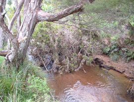
Catchment management plans aim to link environmental issues and functions as well
    as engaging the communities that live and work within catchments. Catchment
    management works with the support of four key principles in mind. They are the
    consideration and support of economic; social; environmental and cultural outcomes.

    The guiding factor behind catchment management planning is the involvement of
    communities. Environment Waikato, under its Regional Plan, recognises the need for
    communities to actively participate in preserving our environment and communities.

    Community based management initiatives are generally more successful than those
    imposed by an external agency. This is mainly due to the fact that there is local
    ownership and connection to the environment.

    This catchment plan is a supporting document to the wider integrated management
    document, the Draft Whangamata Harbour Plan 2007, which provides the strategic
    context for managing the harbour and its catchment across four main issue areas:
    water quality; habitat; sedimentation and flooding; and recreation, boating, access and
    views.

    2.3 Community process
    In most cases it is preferable that a catchment management plan’s community process
    works from a grass roots level up, to ensure community ownership and support of the
    initiative. This process also assists in setting the tone and direction of a catchment
    management plan and drives the desired outcomes.

    In the case of this plan, it is intended that it be developed as a means for further
    community consultation. This is on the basis that significant consultation has already
    been undertaken as part of the Draft Whangamata Harbour Plan development and the
    Draft Whangamata Catchment Management Plan supports that document.

    Any proposed works on private land will only be undertaken upon agreement with the
    land owner on a case by case basis. A public consultation process will confirm both the
    Harbour and Catchment Plans.

3   Legislative and planning framework
    This section is a summary of the legislative framework that guides and directs
    Environment Waikato, in particular its River and Catchment Services Group, in its
    various roles and functions.

    Environment Waikato is responsible for the overall management of rivers and
    catchments in the Waikato region. This work is carried out under the soil conservation,
    river management and flood protection schemes

    3.1 Soil Conservation and Rivers Control Act
        (1941)
    The Soil Conservation and Rivers Control (SCRC) Act (1941) has been replaced in part
    by the Resource Management Act (RMA) (1991), but sections of the SCRC Act are still
    operative and are relevant to this management plan in respect of the responsibilities on
    regional councils (previously catchment authorities) in regard to flooding and soil
    erosion.

    Doc # 1194680                      DRAFT DOCUMENT                                 Page 3
The objects of the SCRC Act are listed below.
a) The promotion of soil conservation.
b) The prevention and mitigation of soil erosion.
c) The prevention of damage by floods.
d) The utilisation of lands in such a manner as will tend towards the attainment of the
objectives of the Act.
3.2 Resource Management Act (1991)
Part II of the Resource Management Act 1991 (and Amendments) outlines the purpose
and principles of the RMA as defined in sections 5, 6, 7, 8.
x Section 5 outlines the purpose of the Act to promote sustainable management of
natural and physical resources.
x Section 6 deals with Matters of National Importance.
x Section 7 addresses Other Matters.
x Section 8 relates to the Principles of the Treaty of Waitangi.
In particular it requires regional councils to develop policy statements and regional
plans which detail how the environment will be managed.
3.3 Regional Policy Statement
The Waikato Regional Policy Statement (WRPS) provides a framework for resource
use, which enables the regional community to achieve its social and economic
aspirations, within the capacity of the environment. Where resource quality is high, it is
the intention of objectives and policies to retain high resource quality. Where resource
quality has been degraded through inappropriate use, the quality of such resources is
intended to be improved over time.
Under the WRPS, Environment Waikato has a primary role for river and hazard risk
management.
The key sections of the Regional Policy Statement that apply to this management plan
relate to are listed below.
x Land and soil.
x Water.
x Indigenous biodiversity.
x Natural hazards.
3.4 Waikato Regional Plan
The Regional Plan implements the Regional Policy Statement. It contains policy and
methods to manage the natural and physical resources of the Waikato region. The plan
applies across the whole of the Waikato region, although some objectives, policies and
rules apply only in specific parts of the region. The plan does not apply below ‘mean
high water springs’.5
5
Mean high water springs: The place on the shore where spring high tides reach on average over a period of time. It
can often be recognised by the upper line of debris on the beach.
Page 4 DRAFT DOCUMENT Doc #11946804 Catchment description
4.1 Location
The Whangamata Catchment is located on the east coast of the Coromandel Peninsula
in the southern part of the Coromandel Zone (see Figure 1). The catchment contains
81 kilometres of stream. The main contributor to Whangamata’s harbour is the
Wentworth River. Streams flow from south-west to north-east.
For the purpose of this catchment management plan, the area of concern is some
5,376 hectares of land. This area is consistent with the catchment zones identified for
management purposes under the Peninsula Project.
Figure 1. Location of Whangamata Catchment
4.2 Physical characteristics
4.2.1 Geological
The Whangamata catchment is part of the Hauraki volcanic area with some influence
from eruptions on Mayor Island. In geological terms this area is relatively young
(Miocene areaBoth Coromandel andesites7 and Whitianga rhyolites8 make up the parent material of
the Whangamata catchment. Most of the andesites have been altered due to
hydrothermal activity, but fresh andesite can be found, and is quarried just north of
Whangamata on McBeth’s Road.
The Whangamata catchment was included in the 1975 Land Inventory Survey as part
of the Coromandel Thames Counties area. The classification of soils was carried out by
the then Department of Lands and Survey. This information is still relevant throughout
New Zealand and is still the most complete record of soils and land use capabilities.
The information in Table 1 below is sourced form this data set.
Table 1: Soil classification – Whangamata catchment
Soil Name Topography Soil Limitations for Area
location classification use (%)
Pinaki sand Dunes inland from Yellow to brown Low nutrient status 7
coast sands seasonally droughty.
Whangamata hill Easy rolling and Yellow to brown Soils of low nutrient 52
soils rolling land loams status and impeded
drainage.
Tangatera step Steep and very Yellow to brown Low nutrient status 13
land soils steep earth liable to severe
sheet and slip
erosion.
Te Kie and Aroha Steep and very Brown granular Weekly developed 14
step land soils steep clays structure, medium to
low nutrient status
liable to erosion.
Mangonui hill Easy to rolling land Brown granular Low nutrient status 11
soils clays and poor drainage.
Ohinemuri loamy Flood plains and Recent soils Weakly developed 3
sand river beds soil structure. High
nutrient status,
subject to flooding.
4.2.2 Land use
There is land suitable for production farming (and not prone to erosion) in the
Whangamata catchment but the use of most of these areas is limited by poor soil
fertility. This is reflected by the majority of land in the catchment with farming potential
being used for production forests. Like so many of the catchments on the east coast of
the Coromandel Peninsula, land surrounding the headwaters of the Whangamata
catchment is managed as production forests. Between harvesting events the forest
provides for water and soil conservation as well as regulating run-off during flood
events in the lower catchment. This benefit is diminished after harvesting for a term of
approximately seven years, until a new crop is established.
Unlike its neighbouring catchments (Otahu and Wharekawa) the Whangamata
catchment has little floodplain. This makes the already poor soil fertility worse and
limits intensive farming potential. Only 10 per cent of the catchment area is still
managed for pastoral farming and there are no dairy farms. Agriculture is largely
drystock or run-off blocks with less than one per cent in horticulture.
Impacts from historical tree felling, gold mining and land clearance are still being felt in
the middle and upper catchment areas with poor forest canopy structure and unstable
7
Andesite: Fine grained brown or greyish volcanic rock.
8
Rhyolite domes: Granite-like land forms created through a build up of fine grained volcanic rock.
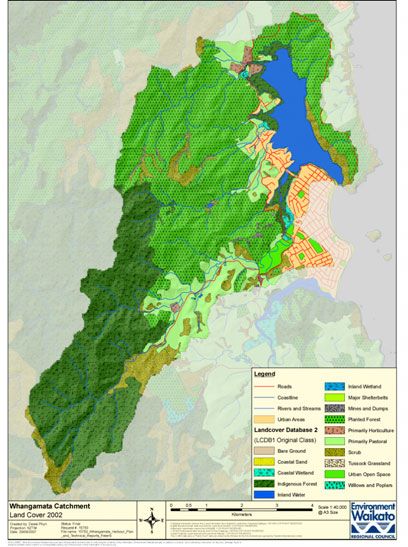
Page 6 DRAFT DOCUMENT Doc #1194680hill sides. Land use data shows that more than 40 per cent of the catchment area is
under plantation forest. A further 36 per cent is covered by indigenous forest or scrub
(refer to Figures 2 and 3). These areas have relatively high erosion potential. Most of
the land is steep or mountain country with unstable landforms. The Department of
Conservation manages 31 per cent of the catchment area.
4.3 Social
Like so many communities on the Coromandel Peninsula, Whangamata is home to a
fairly small permanent population. This population increases from 4,000 to 50,000 over
the Christmas period, putting pressure on infrastructure9 and local resources. Support
for projects and community initiatives is hard to come by. Permanent residents and
land owners absent for most of the year have distinctly different perspectives in terms
of priorities related to the area.
Whangamata is identified as one of the seven main serviced settlements and as such
is an area where future growth should be concentrated. The 2006 Census10 results
show that Whangamata dropped 10.3 per cent of its usually resident population to go
from 3855 to 3567. When you lay the population figures over the housing statistics it
becomes apparent that the non-resident population is increasing. This is supported by
the numbers of unoccupied dwellings on census night. In 2001 55 per cent of dwellings
were unoccupied and in 2006 this increased to 60 per cent unoccupied.
Dwelling numbers increased from 4026 (2001) to 4182 (2006). In 2016 it is projected
that there will be 5017 dwellings and 4846 usual residents. By 2026 it is projected that
there will be 5664 dwellings and 5709 usual residents. These growth projections are
being re-done as a result of the 2006 Census data and the new projections should be
available at the end of July 2007.
4.3.1 The Coromandel Peninsula Blueprint Project
The Coromandel Peninsula Blueprint project is all about planning where, what and how
people can do things in and on the land and waters of the Coromandel Peninsula. The
project, lead by Environment Waikato and Thames Coromandel District Council, is
about determining what is 'appropriate growth' particularly in light of the projected
growth for the district. A significant challenge is managing the growth demands and
pressures whilst still protecting important community values. The district's communities
have already told Thames Coromandel District Council what they want through
initiatives such as community plans and community outcomes. The Coromandel
Peninsula Blueprint Project will build on these community visions.
4.4 Tangata whenua
There are four iwi with direct interests in the Whangamata catchment. They are Ngati
Pu, Ngati Whanaunga, Ngati Hako and Ngati Tamatera. A statement of significance
was prepared by representatives of Hauraki iwi for the Draft Whangamata Harbour
Plan which identifies the Whangamata Harbour as being of cultural, spiritual and
historical significance to Hauraki iwi. Listed below are Hauraki iwi's goals for the
Hauraki environment.
x To ensure that we sustain and enhance the mauri of the environment as kaitiaki.
x That protecting our past including cultural heritage sites, waahi tapu, places,
landscapes and associated knowledge is a priority for Hauraki kaitiaki.
x To maintain and enhance our kaitiaki roles with the environment.
x To make informed decisions about the Whangamata Harbour, its surrounding
environment and heritage.
9
Examples of infrastructure include roads, powerlines, sewage systems, water services and other organisational
structures and services.
10
Source: Statistics New Zealand website: http://www.stats.govt.nz/census/2006-census-data/default.htm.
Doc # 1194680 DRAFT DOCUMENT Page 7x To ensure that central and local government, industry and local communities are
upholding their Treaty of Waitangi obligations and that these are reflected in the
decisions that are made.
x To ensure that communities understand and value Hauraki iwi involvement in
environmental management and heritage protection.11
A heritage map of the harbour and part of the catchment was compiled by the Hauraki
MƗori Trust Board in 2005. This identified sites of significance to MƗori. Areas used for
recreation, kaimoana, ancient pa sites and archaeological sites were identified along
with locations suitable for habitat restoration. Locations of environmental concern were
also identified.
4.5 Ecological
Under Environment Waikato’s Key Ecological Site (KES) survey, no land areas of
significant ecological value were identified in the catchment. The closest KES is the
Otahu Estuary.
The Otahu Estuary is regarded as one of the most significant estuarine environments
for protection on the Coromandel Peninsula by both the Department of Conservation
and Environment Waikato. This estuary and Whangamata Harbour are identified in the
Waikato Regional Coastal Plan as areas of significant conservation value.
New Zealand has been divided into 268 different ecological districts based on
geological, topographical, climatic and biological features that together define a
characteristic landscape. Similar districts combine to form an “Ecological Region”.
The Coromandel Ecological Region is divided into eight ecological districts. For ease
these have been reduced to four districts, largely based on topography. The
Whangamata catchment sits in the Tairua Ecological District. Recognising and working
within the parameters of an ecological region is important especially in relation to plant
species.
From a biodiversity protection viewpoint, the Whangamata catchment is not a priority
for animal pest control work on Department of Conservation-administered land when
compared to high value sites like Moehau in the northern Coromandel. However, as a
result, animal pests have led to a decline in forest health and a collapse of the forest
canopy in areas in the southern part of the catchment.
While most of the biodiversity value in the catchment is around the saltmarsh and
wetland areas, a post breeding season dotterel flock site is located in the harbour and
is home to an estimated 30 to 40 birds. Populations of the threatened Fern bird and the
Moko skink can also be found in the lower reach of the Wentworth River system.
4.6 Key stakeholders
x Iwi:
- Ngati Pu
- Ngati Whanaunga
- Ngati Hako
- Ngati Tamatera.
x Hauraki Mãori Trust Board.
x Thames Coromandel District Council.
11
Hauraki Iwi Environmental Plan, produced by Hauraki Màori Trust Board, March 2004, p. 12
Page 8 DRAFT DOCUMENT Doc #1194680x Department of Conservation. x Land owners and residents. x Forestry – Rayonier. x Care groups. x Local community interest groups. Other Mãori interest groups have expressed an interest in the catchment and collectively, they along with the named iwi (above) have formed a kaitiaki group. A nominated spokesman has been appointed for this group. Figure 2. Land use in Whangamata catchment Doc # 1194680 DRAFT DOCUMENT Page 9
Figure 3.   Aerial view of Whangamata catchment

Page 10                          DRAFT DOCUMENT   Doc #1194680
5   Catchment assessment
    An inspection of the physical characteristics of the Whangamata catchment was carried
    out by Environment Waikato staff in April 2007. A detailed account of the condition of
    the catchment and potential works required can be found in Appendix 1.

    Three main sub-catchments and one minor tributary make up the Whangamata
    catchment. For the purpose of the inspection the main catchments of focus were:

    x   Wentworth River
    x   Waikiekie Stream
    x   Te Weiti Stream
    x   Otuwhete Stream (minor tributary).

    Due to time constraints, the field and desktop assessments focused mainly on the
    stream channel and surrounding land. While there are benefits to be gained within the
    wider catchment, it is considered these are less significant and that the greatest gains
    will be made by focusing on streams and surrounding land. These gains can be made
    in a relatively short timeframe by getting land owners actively involved in soil
    conservation and farm plans. Consideration of land use in the catchment area and
    associated issues/benefits has been noted. Further investigation and consultation with
    land owners is needed to assess these further.

    5.1 Values
    A number of biodiversity and cultural values were identified through discussions with
    groups and individuals as part of the Draft Whangamata Harbour Plan 2007. The key
    values identified are listed below.

    x   Estuarine habitat.
    x   Kaimoana (seafood) gathering grounds in the harbour.
    x   Cultural and historical sites.
    x   Recreational use and amenity value of the harbour and catchment.
    x   Native bush in the headwaters and Department of Conservation lands.
    x   Rare animals including the Moko skink, the Fern bird and the New Zealand
        Dotterel.

    Further discussion on these and other values will be had with the community as part of
    the consultation process.

    5.2 Key issues
    The key issues in the Whangamata catchment are listed below.

    x   Stream bank erosion.
    x   Sedimentation of the estuary.
    x   Degraded water quality.
    x   Some harmful impacts on biodiversity values.
    x   Animal pests such as possums are impacting on native plants and animals, and
        their impact on vegetation is resulting in erosion and soil run-off in some areas of
        the catchment (particularly in the forested areas of the upper catchment).

    Harvesting of production forestry and resulting sediment run-off has also been raised
    as an issue through consultation on the Draft Whangamata Harbour Plan 2007. A
    significant percentage of the catchment is in production forestry (largely in the steeper
    areas) and in the first few years following harvesting there can be a higher risk of
    erosion. This issue has been addressed under the sub-catchment sections that follow.

    Doc # 1194680                      DRAFT DOCUMENT                                 Page 11
Environment Waikato’s ongoing efforts on this issue will also ensure that forestry
activities are aligned with existing and emerging ‘best practice’.
5.3 Wentworth River
The Wentworth River Catchment is the largest water flow contributor to the
Whangamata Harbour and the largest concentrated area of pastoral land.
Approximately 50 per cent of the catchment is administered by the Department of
Conservation, and a further 25 per cent is under production forest (mainly the northern
slope of the catchment). The main stem of the Wentworth River channel flows for more
than 10 kilometres.
Approximately 70 per cent of the main Wentworth channel is fenced to stock class
standard and prevents stock from accessing the stream bed. Of the seven tributaries in
this catchment area only the Wairoa Stream has any significant riparian protection (90
per cent fenced, good riparian (stream bank or river bank) cover 90 per cent).
Figure 4. Cattle next to the Wentworth River
Considerable effort has been made by the Wentworth Rivercare Group (supported by
Environment Waikato) over the last 10 years to engage and support land owners in the
catchment to fence and plant the river banks. Where land owners have taken up works,
good riparian vegetation exists and is protecting the banks. This was demonstrated in
2006 when an isolated ‘weather bomb’ struck the catchment. Areas fenced and
planted received minimal to no damage, areas unfenced with little or no vegetation
were badly eroded.
Unfortunately not all land owners in the catchment took up the assistance offered by
this group. The outcomes achieved by Wentworth Rivercare are testimony to what can
be achieved by community initiatives.
The lower reach of the Wentworth River has been a key area for the Whangamata
community in the mangrove management debate and is affected by the Hetherington
Road causeway. The presence of mangroves in the Moanaanuanu Estuary and the
associated sedimentation is likely to be reducing the hydraulic capacity12 of the
river/estuarine system. Sediment is currently accumulating in the estuary and the
extent of mangroves is expanding as a result (refer Technical Report 2007/16
Wentworth River Flood Hazard Assessment Environment Waikato document number
1183283).13
12
Hydraulic capacity: combined water volume and flow rate.
13
Environment Waikato. 2007: Wentworth River Flood Hazard Assessment 2007. Environment Waikato Technical
Report 2007/16, Environment Waikato, Hamilton.
Page 12 DRAFT DOCUMENT Doc #11946805.3.1 Lower reach (from the causeway upstream to old quarry)
The old quarry referred to is located right next to Wentworth Valley Road approximately
2.25 kilometres in from State Highway 25. This reach is generally well fenced and
planting of native species has been carried out by the Wentworth Rivercare Group.
Proposed works in this section are relatively minor as most of the issues relate to the
stream channel or wetland areas.
5.3.1.1 Issues
x Large possum numbers in the upper catchment degrading the forest.
x Pampas growth on stream margins (less than 10 per cent).
x Lack of riparian vegetation (present, but needs in-fill planting).
x Isolated blockages within the stream need to be removed.
x Silting up of the stream reducing channel capacity and increasing water
temperature.
x Flooding between the causeway and the golf course (refer below for summary of
assessment).
x Hetherington Road causeway causing a dam effect at the mouth of the river
x Increased sedimentation of the estuary.
x Unauthorised stopbank and infilling next to the upstream side of the bridge.
Flooding
As part of the development of this catchment management plan a technical
investigation has been carried out of lower Wentworth River flooding (refer
Environment Waikato Technical Report 2007/16 ‘Wentworth River Flood Hazard
Assessment’).
Modelling was undertaken assessing three scenarios – the existing channel and
estuary, the future situation with mangroves retained and the future situation with
mangroves removed. The results indicate that there could be flood hazard potential in
built up areas northwest of Martyn Road for both future scenarios, although the extent
of this is greater if the mangroves are retained.
Given that there is little historical information about the channel dimensions of the
Wentworth River and Moanaanuanu Estuary it is recommended that five yearly channel
surveys be undertaken. Once sufficient site specific information is available, over say
10 years, it will be possible to reassess flood hazards and develop appropriate flood
mitigation options. This timeframe will also allow for other catchment management
initiatives to be implemented.
5.3.1.2 Proposed actions
x Rock work or willow layering on badly eroding corners.
x Stream bank fencing.
x Clearance of pampas (spray or mechanical removal) to reduce seed source and
spread.
x Willow and/or poplar pole planting in highly eroding areas.
x Planting of native riparian species.
x Removal of mangrove seedlings on an annual or as needed basis.
x Initiation of channel surveys with consequent adaptive management practices.
Doc # 1194680 DRAFT DOCUMENT Page 13Figure 5. Blockage in Wentworth River channel
5.3.2 Mid section (old quarry to approximately 1.5 kilometres
upstream)
5.3.2.1 Issues
x Stream is virtually unfenced along this reach.
x Stream banks are eroding badly with no vegetation cover and full stock access to
the bank and stream bed.
5.3.2.2 Proposed actions
x Fencing is needed on both sides of the stream.
x Appropriate planting to shade the stream and stabilise the banks is required.
x Removal of debris and blockages.
x Re-shaping of channel sides in key areas.
x Poplar and/or willow pole planting for erosion protection.
This section is the most degraded in the catchment area and probably the greatest
contributor of sediment within the Whangamata catchment.
5.3.3 Upper reach (to the ford)
5.3.3.1 Issues
This reach is generally well vegetated.
x There are some exotic species present such as wattle.
x Some existing fencing is in place along the stream bank.
x Forest health is poor due to possums and goats.
x Potential issues with production forestry. For example, wood unsuitable for sale is
left on harvested land and then mobilised during flood events causing debris dams;
sediment run-off during harvesting.
5.3.3.2 Proposed actions
x Possible digger work to carry out minor repairs and to remove some in stream
vegetation.
x Upgrade fencing to cattle class standard.
x Undertake plant pest control (pampas and wattle).
x Undertake possum and goat control in the upper catchment.
Page 14 DRAFT DOCUMENT Doc #1194680x Monitor the annual rate of harvest in each catchment to avoid removing significant
catchment areas in short time frames.
x Liaison with Environment Waikato’s Resource Use Group to ensure appropriate
conditions relating to managing the harmful effects of run-off and sedimentation
during forestry harvesting are implemented and monitored. For example, use of
management methods on production forest land specific to the site to decrease
impact of debris dams; increased silt traps during harvesting.
Figure 6. Slumping of the riverbank and stock access
5.3.4 Tributaries
5.3.4.1 Issues
x Majority are unfenced and poorly managed.
x Potential issues with production forestry. For example, wood unsuitable for sale is
left on harvested land and then mobilised during flood events causing debris dams;
sediment run-off during harvesting.
5.3.4.2 Proposed actions
x It is recommended that the stream be fenced to stock class standard and planted
appropriately.
x The first tributary on the left when entering into Wentworth Valley Road flows from
the now capped landfill. This area if full of pussy willow and is unfenced; some
native vegetation exists. Cattle have access to this site. This arm of the catchment
is a prime location for wetland restoration works. Not only would the area’s
appearance and biodiversity improve, appropriate planting would also assist in the
uptake of nutrients or leachate14 (if it occurs) from the site.
x Liaison with Environment Waikato’s Resource Use Group to ensure appropriate
conditions relating to managing the harmful effects of run-off and sedimentation
during forestry harvesting are implemented and monitored. For example, use of
management methods on production forest land specific to the site to decrease
impact of debris dams; increased silt traps during harvesting.
14
Leachate is rainwater that seeps through the landfill and becomes contaminated. If not contained and managed
properly, leachate can get into our waterways, coastal areas and groundwater, polluting them.
Doc # 1194680 DRAFT DOCUMENT Page 155.4 Waikiekie
Close to two thirds of the Waikiekie sub-catchment is under production forest
management. Of the 5.8 kilometres of the main stream channel, only 1.4 kilometres
runs through farmland. The bulk of the catchment is owned or managed by forestry
companies with only one other significant land owner. Environment Waikato undertook
some minor river works in the form of vegetation clearance in the lower reach of this
catchment in 2006 and is supporting land owners in the middle reach with fencing and
planting of the stream. The land in the lower reach is owned by Thames-Coromandel
District Council and Land Information New Zealand.
5.4.1 Lower reach (below state highway bridge)
5.4.1.1 Issues
x Floodplain blocked and storage capacity limited due to weeds.
x Council boardwalk trapping debris.
x Floodplain is slowly rising due to silt deposition after each flood causing flooding to
properties next to it.
5.4.1.2 Proposed actions
x Floodplain may need to be reshaped to remedy flooding.
x Continued maintenance needed to maintain channel capacity.
x Consider deepening the stream bed to act as a sediment trap where practicable
and effective.
5.4.2 Middle reach (above state highway to tributary confluence)
5.4.2.1 Issues
x Isolated blockages in the stream channel.
x Parts of the reach are fenced and additional planting is needed.
x Watt’s Road wetland area is currently over-run with willow.
x Some minor weed control is needed.
5.4.2.2 Proposed actions
x Wetland area fenced to cattle class standard with appropriate planting.
x Upgrade existing stream fences.
x Weed removal on key sites.
5.4.3 Mid reach to forestry boundary
5.4.3.1 Issues
x Weeds (mainly pampas).
x Existing fences are degraded and stock have access to the stream in places.
x Eroding stream banks in places.
x Forest health is poor due to possums and goats.
x Potential issues with production forestry. For example, wood unsuitable for sale is
left on harvested land and then mobilised during flood events causing debris dams;
sediment run-off during harvesting.
5.4.3.2 Proposed actions
x Undertake weed control.
x Re-shaping of channel sides in key areas.
x A thread of native exists on both the left and right banks where infill planting could
be undertaken to gain maximum benefit from these margins.
x Undertake possum and goat control in the upper catchment.
x Liaison with Environment Waikato’s Resource Use Group to ensure appropriate
conditions relating to managing the harmful effects of run-off and sedimentation
during forestry harvesting are implemented and monitored. For example, use of
Page 16 DRAFT DOCUMENT Doc #1194680management methods on production forest land specific to the site to decrease
impact of debris dams; increased silt traps during harvesting
5.5 Te Weiti
As with the Waikiekie sub catchment, the upper reaches of the Te Weiti Stream are
largely covered by plantation forest with some native riparian vegetation. Of the 2.8
kilometres of main channel only one kilometre runs through pasture land or residential
reserve. In 2006 work began to increase the channel capacity in the lower reach below
the state highway bridge and where the stream enters the harbour, and to stabilise the
stream banks by removing cattle access and planting appropriate species.
5.5.1 Lower reach (below the state highway)
5.5.1.1 Issues
x Sedimentation of the stream and bed build-up which worsens flooding of properties
(mainly paddocks, lawns with some risk to houses).
x Poor fencing which allows stock access to the stream and bank erosion.
5.5.1.2 Proposed actions
x Regular maintenance of the stream channel through the mangroves into the
harbour.
x Upgrade the stream fence and plant with appropriate natives.
x Maintain existing silt traps.
x Investigate potential in this area to carry out coastal wetland enhancement for
biodiversity purposes.
Figure 7. Planting on coastal margin of Te Weiti Stream
5.5.2 Upper reach (above the state highway)
There is only one land owner in this reach before it enters production forest lands.
5.5.2.1 Issues
x Possum browse on poplar poles risking poplar survival rate and erosion reduction
potential.
x Weed species are present such as pampas and pussy willow causing stream
channel blockage.
Doc # 1194680 DRAFT DOCUMENT Page 17x Potential issues with production forestry. For example, wood unsuitable for sale is
left on harvested land and then mobilised during flood events causing debris dams;
sediment run-off during harvesting.
5.5.2.2 Proposed actions
x Replace poles that have been lost due to possum browsing.
x Undertake possum control.
x Remove pampas and pussy willow in and on channel.
x Complete stream fencing and upgrade boundary fence.
x Liaison with Environment Waikato’s Resource Use Group to ensure appropriate
conditions relating to managing the harmful effects of run-off and sedimentation
during forestry harvesting are implemented and monitored. For example, use of
management methods on production forest land specific to the site to decrease
impact of debris dams; increased silt traps during harvesting
5.5.3 Tributary
This tributary requires fencing of its upper end and maintenance of existing silt traps.
5.6 Otuwhete Stream/Julian Drive
The majority of the land draining into this area is in horticulture (citrus fruit) and small
lifestyle blocks. Investigation into fertiliser use and nutrient budgets would be
worthwhile to assess if nutrient run-off is an issue here.
5.6.1.1 Issues
x Excessive gravel deposition in the stream channel causing bank erosion and loss
of channel capacity during high flows.
x Cattle access to the waterway causing bank erosion and sediment contribution to
the stream.
x Poor stream shading which increases temperature and reduces biodiversity
potential.
5.6.1.2 Proposed actions
x Remove gravel deposition below Julian Drive.
x Undertake riparian fencing and planting.
x Investigate potential in this area to carry out coastal wetland enhancement for
biodiversity purposes.
6 Methods and outcomes
This section provides an overview of what would be involved in each component of
work, the benefits and the expected outcomes.
6.1 Land management protection
Land management protection in this instance means enhancement work not associated
with streams or wetlands. This work is essential in ensuring the big picture approach is
taken and that the focus does not fall solely on stream works.
6.1.1 Methods
x Retire bush areas from stock access.
x Carry out pest control operations in pine and native bush on both public and private
land.
x Encourage further forest fragment and riparian retirement.
x Encourage change to appropriate land use or management methods in some of the
steeper terrain with a focus on Tangatera step land soils initially.
x Rat control project around the harbour fringes and coastal wetlands.
Page 18 DRAFT DOCUMENT Doc #11946806.1.2 Benefits
Land management protection works have the potential to have the greatest overall
benefit to biodiversity by reducing animal pest numbers and allowing native species to
successfully reproduce.
The focus on land cover and pest reduction would see improved forest structure with
the ability to provide greater stability during rain events and consequently less erosion,
downstream sedimentation and harbour infilling.
Figure 8. Setting a rat trap
6.2 Riparian enhancement
For the purpose of this document riparian enhancement includes stream and wetland
fencing, planting (both native and exotic species) and weed control.
6.2.1 Methods
x Native planting – planting of eco-sourced, site specific natives at 1.5 metre
spacings (refer Appendix 2).
x Pole planting – Poplar and matsudana willow pole planting. Used for their quick
rowing dense root structure that binds soil. Species used do not form dense
thickets and are a sterile variety.
x Fence out all waterways where stock have access, including tributaries and drains,
to stock class standard.
x Wetland fencing to cattle class standard.
x Weed control – removal of weeds such as pampas and woolly nightshade either by
chemical application or mechanical means.
x In areas where erosion is active, it is better to use willow stakes, or whole trees
(layering). In such cases, there needs to be enough channel width to retain
adequate flood capacity within the channel.
6.2.2 Benefits
x Decreased water temperature through shading.
x Creation of fish spawning habitat by retiring stream margins and planting.
x Decreased stream bank erosion by removing stock pressure and by planting
appropriate plant species.
Doc # 1194680 DRAFT DOCUMENT Page 19x Fencing:
- increased water quality, by reducing the direct (cows defecating in the stream)
and indirect (run off) inputs of faecal matter and nutrients
- reduced stream bank erosion and surface erosion
- stream bed health and stability improved – stock crossing/walking in the stream
bed impacts on the structure within the channel and decreases aquatic
invertebrate habitat.
x Increased biodiversity by planting eco-sourced natives and creating new habitat.
6.2.3 Outcomes
x Improved water quality.
x Enhanced biodiversity.
x Stabilised stream banks.
x Reduced sedimentation.
6.3 River and flood management
6.3.1 Methods
x Removal of silt / mud that settles in the channel to maintain adequate channel
capacity for each stream outlet on the harbour fringes. This will be done mainly by
hydraulic excavator, and in some areas, the material will require complete removal
from the Coastal Marine Area (CMA) where there is deemed a significant impact on
the marine ecosystem.
x Repair eroding areas through site specific works and soil conservation planting and
fencing.
x Removal or re-alignment of isolated whole trees, stumps or limbs that have fallen
into the channel and which are likely to create an obstruction to flow or increase
erosion.
x Removal of obstructive vegetation from the floodplain that may cause localised
flooding. This includes species such as pampas, flaxes, willows and even
mangroves.15
x Undertaking simple erosion control work within channels.
x Spraying vegetation.
6.3.2 Benefits
x Increased channel capacity.
x Reduced risk of stream bank erosion.
6.3.3 Outcomes
x Adequate flow path in heavy rainfall events.
x Property and infrastructure protected.
x Improved water quality.
15
Currently, mangrove seedlings only can be removed under the conditions of the current resource consent granted
to Whangamata Harbour Care Inc. earlier in 2007. For more information on the pros and cons of mangrove
management, see the full harbour plan document and the Whangamata Mangrove Management Options Report
available from Environment Waikato or online at www.ew.govt.nz/projects/iwhangamata/index.htm. The report also
contains a copy of the short publication, ‘For and Against Mangrove Control’, produced by the National Institute for
Water and Atmospheric Research (NIWA).
Page 20 DRAFT DOCUMENT Doc #1194680Figure 9. Stream bank erosion in the Wentworth River
7 Implementation
On the basis that the community and Environment Waikato consider that addressing
the sedimentation issues in the Whangamata catchment is a priority, it is proposed that
the implementation of works be undertaken within a short to medium term time frame
(10 years). The priorities for the first year in order of significance are identified below
and are provided as guidance only – a works programme will only be confirmed once
consultation with the community has been completed. It should be noted that the
implementation of works will be dependent upon land owner participation and funding.
7.1 Community process
The first step in confirming this plan will be to consult with and engage the community.
That process will take place in association with the informal consultation process for
the Draft Whangamata Harbour Plan between September and December 2007 (refer
Environment Waikato document number 1187143). The community within this
catchment is fragmented and diverse with a high percentage of non-resident
ratepayers.
Steps in gaining community and land owner involvement in the catchment
management plan specifically will include:
x Kitchen meetings (small semi-formal meetings) with land owners and interest
groups to identify their key issues and discuss proposals identified in this plan.
x Meeting with iwi to hear their key concerns about the catchment and how they feel
the mauri of the catchment can be sustained and enhanced.
x Holding a community information day.
x Use of local media to keep the community up to date with progress and
developments.
Currently, mangrove seedlings only can be removed under the conditions of the
current resource consent granted to Whangamata Harbour Care Inc. earlier in 2007.
Further consultation on mangrove management will be gathered and assessed
Doc # 1194680 DRAFT DOCUMENT Page 21following the distribution of Environment Waikato’s Whangamata Mangrove
Management Options Report16 and a questionnaire.
7.2 Work programme
The initial priority for work is the Wentworth River sub-catchment. This is the largest
river system in the Whangamata Catchment and has the highest silt loading.
Environment Waikato has already commenced some works on the Waikiekie and Te
Weiti streams and this work will continue at a low level at present.17
The key steps in implementation for the Wentworth are as follows.
1. Reduce soil erosion and the amount of silt and sediment entering the harbour from
the Wentworth River sub-catchment by:
x fencing and stabilisation planting the river banks, targeting areas of active
erosion (main channel first, tributaries second)
x removing debris and blockages from the river and re-shaping incised banks
where needed.
2. Initiate a river survey of the lower Wentworth River for the purpose of monitoring
changes which may have an impact on flooding.
3. Establish an animal pest control programme in the upper catchment.
4. Undertake restoration planting of riparian, wetland and bush areas for the purpose
of improving biodiversity and reducing erosion.
The time frame for implementation will be dependent upon funding and the level of
participation that can be gained from land owners.
8 Costs
A detailed breakdown of expected cost is attached as Appendix 1. All recommended
works costs are an estimate only, based on today’s costs for materials and works.
Actual price will vary depending on uptake of work, land owner contribution, industry
price increases and availability of materials.
Below is a summary of the anticipated costs for each programme of works. These
figures do not allow for annual maintenance.
Table 2 Land management protection
Work/Materials Cost/Item No. required Total cost
Fencing – forest fragments (8 $16.00/metre 5000 metres $30,000.00
wire post and batten)
Animal pest control – aerial $26.00/ hectare 3600 hectares $93,600.00
Ground based animal pest $52.00/hectare 300 hectares $15,600.00
control
Total cost $139,200.00
16
Environment Waikato. 2007: Draft Whangamata Mangrove Management Options report. Environment Waikato
Internal Series 2007/15, Environment Waikato, Hamilton. Available online at
www.ew.govt.nz/projects/iwhangamata/index.htm.
17
In terms of the relationship between mangroves and flood risk in this area, it should be noted that a number of
commercial and residential properties near the Wentworth River and surrounding areas will still be vulnerable to
flooding in the future whether mangroves are removed or not (hence the need for the river and catchment works as
outlined in this Draft Whangamata Catchment Management Plan 2007).
Page 22 DRAFT DOCUMENT Doc #1194680Table 3 Riparian enhancement
Work/Materials Cost/Item No. required Total cost
Native plants (inc labour) $5.00 per plant 14,500 plants $72,500.00
Riparian fencing $5.00/metre 24,000 metres $120,000.00
Spraying of weeds $25.00/hour 240 hours $7,000.00
Pole planting including labour $22,500.00
Total cost $222,000.00
Table 4 River and flood management
Work/Materials Cost/Item No. required Total Cost
Remove blockages $18,000.00
Repair corners $28,000.00
Willow removal $13,000.00
Mangrove removal and coastal TBA TBA $100,000.00
excavation
Silt traps $3,000.00
Floodplain reshape/open $7,000.00
Total cost $169,000.00
Table 5 Survey and design costs
Work/Materials Cost/Item No. required Total Cost
Survey* $15,000.00 2 $30,000.00
Flood modelling $1,500.00 6 $9,000.00
Total cost $39,000.00
Table 6 Total cost – tables 2-5
Sub-total (tables 2-5) $570,000.00
Plus supervisory and liaison costs $100,000.00
Total cost $670,000.00
* Note three surveys to be carried out over a 10 year period, including one at the
beginning of the works programme and two within the following 10 years.
9 Funding
Environment Waikato funds river and catchment services on the Coromandel
Peninsula under the Peninsula Project Funding Policy (Environment Waikato document
number 924353). This policy provides for a Peninsula, Regional General Rate and land
owner or community contribution to soil conservation, river management and flood
protection works. At this stage, proposed costs for the catchment management
programme total $670,000 (this figure does not include ongoing annual maintenance
costs).
The Peninsula Project Funding Policy also provides for targeted rates to be applied
where there is significant local community benefit from works. This typically applies to
flood protection programmes, but could equally apply to a harbour and catchment
management programme where the community supported significant works being
undertaken in a short-term time frame. The proportion of funds to be recovered from
the particular community would be determined on a case by case basis.
Doc # 1194680 DRAFT DOCUMENT Page 23The Peninsula Project is already significantly committed to existing projects in other communities and catchments. Under existing funding the implementation of the Whangamata Catchment Management Plan would be carried out over the next 10 years or so. In order to reduce this time frame, targeted funding would be required. Consultation with the community on funding, rating and costs of future works, services and activities related to carrying out the harbour plan's wider recommendations will also take place at each relevant stage as appropriate. 10 Monitoring and reporting The implementation of this plan will be overseen by the Coromandel Zone Manager and progress will be reported to Council via the Coromandel Liaison Subcommittee. Updates will be provided to the community of Whangamata via existing community networks and local media. Contact will be maintained with local iwi through out this process. An outcome monitoring programme is being implemented in the neighbouring Wharekawa Catchment. This catchment is similar in size, land use and issues to Whangamata and will provide useful information as works progress in both catchments. Page 24 DRAFT DOCUMENT Doc #1194680
Appendix 1                    Assessment of individual
streams
Ground inspections of the streams flowing into the Whangamata Harbour were carried
out on 2 and 17 April 2007 by Emily O’Donnell and Roger Spooner. Results of those
inspections are summarised as follows:

1. Wentworth River
   a) Causeway to Old Tairua Road bridge
      x Mangroves and general vegetation appear to be engulfing the floodway
         area
      x Pampas has infested banks below Old Tairua Rd bridge (350m)
      x This whole reach appears to be silting up. The Golf Course has complained
         about the increased incidence of flooding.

   b) Old Tairua Road to Wentworth Valley Road (through Golf Course) - 2.2 km
      x Isolated blockages in channel need removing

   c) Golf Course to Water supply access bridge - 1.3 km
      x Areas on LB need fencing
      x RB is fenced with natives
      x Isolated blockages need removing
      x Eroding corners need to be repaired
      x Pole planting required on outside of bends
      x Isolated clumps of pampas need spraying [minor]

   d) Access bridge to old quarry site - 2.30 km
      x Both sides generally well fenced with natives
      x Need to upgrade nominal fencing and complete fencing
      x Isolated blockages need to be removed
      x Willows growing in channel
      x Eroding corners that need repairing
      x Pole planting required
      x Pampas and small willows need to be sprayed out
      x Couple of bad corners to rock/layer etc.

   e) Old Quarry to logged area - 1.50 km
      x Virtually unfenced and eroding badly in places through this area – very open
      x Fencing needed on both sides
      x Pole planting needed both sides
      x Allow repairs to say 6 corners

       x   Machine tidy some corners
       x   Piles of pine slash are lying in the floodplain as result of the recent logging
           operation

    f) Logged area to Ford - 0.7 km
       x Established riparian vegetation on both banks
       x Fenced (fairly old and messy) but effective
       x Some dead willows will need to be removed
       x Allow for some machine time to carry out repairs

    g) Above Ford
       x Stream fringes are in native and/or retired, with virtually no fencing
            required.

Doc # 1194680                      DRAFT DOCUMENT                                  Page 25
x Needs a tidy up to remove blockages/debris in channel
x Pampas on fringes needs to be sprayed
h) Tributaries
i) Swamp near rubbish dump RB
- this stream drains the old dump area, and is likely to contain leachate.
- generally unfenced
- pussy willows should be cleared and followed up with planting and
fencing
ii) Tributary through Dairy farm RB
- unfenced, needs to be fenced and planted [500m]
iii) Muddy stream LB
- unfenced, needs to be fenced and planted over lower 450 metres [min]
iv) Large drain immediately U/S of Muddy LB
- unfenced (500m)
v) Unnamed tributary through farm D/S quarry RB
- both banks unfenced (500m)
- runs through pasture up to old quarry
vi) Unnamed tributary at old quarry RB
- fenced on one side by quarry
- unsure about channel above quarry (700m)
vii) Wairangi Stream LB
- unfenced (200m on 2 sides; 700m on 1 side)
- fringes plantation in upper reaches
viii) Unnamed tributary D/S Connells
- unfenced and eroding (700m)
ix) Wairoa Stream (Connells)
- fenced at bottom end
- not fenced in mid reaches (300m)
- requires pole planting
x) Stream by McNelly property
- needs some fencing and planting (500m)
2. Waikiekie Stream
a) Below State Highway
x Need to continue with maintenance
x Ensure open floodway to harbour – control mangroves, vegetation etc.
x Council boardwalk is obviously trapping debris and silt
x Look at reshaping floodplain.
x It appears that the floodplain is slowly rising due to silt deposition after each
flood
b) Above State Highway to confluence with Tributary – 400m
x Isolated blockages in channel
x Some of this reach is fenced
x Pole planting needed on both sides
c) Tributary Confluence to Forestry – 900m
x Established thread type riparian vegetation on both banks
x Existing fencing on both sides could do with an upgrade
x Pampas needs to be sprayed
x Repair isolated erosion
d) Tributary through Watts Road – 900m
x Tributary generally unfenced
x Remove willows?
x Enhance wetland vegetation especially above road
Page 26 DRAFT DOCUMENT Doc #1194680You can also read