South Waikato District Council Draft Rural Reserves Management Plan - October 2020 Adopted by the South Waikato District Council (Date) - South ...
←
→
Page content transcription
If your browser does not render page correctly, please read the page content below
South Waikato District Council
                                                          Draft
                                    Rural Reserves Management Plan
                                                       October 2020

                                        Adopted by the South Waikato District Council
                                                           (Date)

                                                                                        1

Document Set ID: 539225
Version: 10, Version Date: 22/10/2020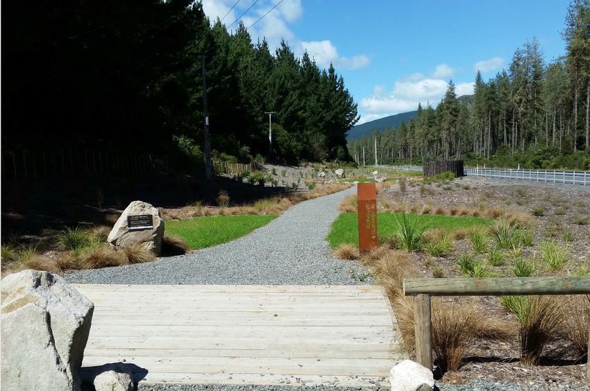
Management of South Waikato District Council
                                     Reserves

                Reserves within the district are mainly classified as either Recreation Reserves or Local
                Purpose Reserves, along with one reserve classified as an Historic Reserve under the
                Reserves Act 1977.

                Reserves include neighbourhood and civic parks, rural or scenic reserves, esplanade
                reserves and sportsgrounds.

                Council adopts the Reserve Act 1977 objectives as its guiding principles in the
                management of its reserves.

                The objectives of the Reserves Act 1977 are:
                •      Emphasise retention of open space for outdoor recreation
                •      Maximise freedom of access to reserves for all people, rather than just a few
                •      Encourage multiple use of reserve land and facilities when feasible and
                      appropriate
                •      Facilitate greater involvement of the public in reserves administration and
                      decision-making

                This document contains the individual reserve management plans for the district’s rural
                reserves.

                Options listed within the “Future Development Options” segment of the individual
                reserve management plan documents are provided as various suggestions for further
                developing or enhancing the reserve for public feedback. Options stated are not to be
                viewed as a guarantee that these will be implemented by Council.

                The South Waikato District Council’s Draft 2020 District Reserve Management Plan
                document establishes clearly defined principles that are compatible with the Act’s
                requirements, community interests, the character and qualities of each reserve and
                outlines policies used for the management of the district’s reserves.

                The Draft 2020 District Reserves Management Plan, Urban Reserves
                Management Plan, Rural Reserves Management Plan and the Sportsground
                Reserves Management Plan documents are available to view by clicking here:
                Reserve Management Plans - Drafts

                A hard copy of each Plan will be available to view at the SWDC Office in Tokoroa, the Jim
                Howland Centre, Putāruru and the Tīrau I-Site.

                These are South Waikato’s reserves. These are OUR reserves. These are YOUR
                reserves.

                Have your say on how our reserves are managed, and the options put forward
                for the further development of our reserves!

                                                                                                            2

Document Set ID: 539225
Version: 10, Version Date: 22/10/2020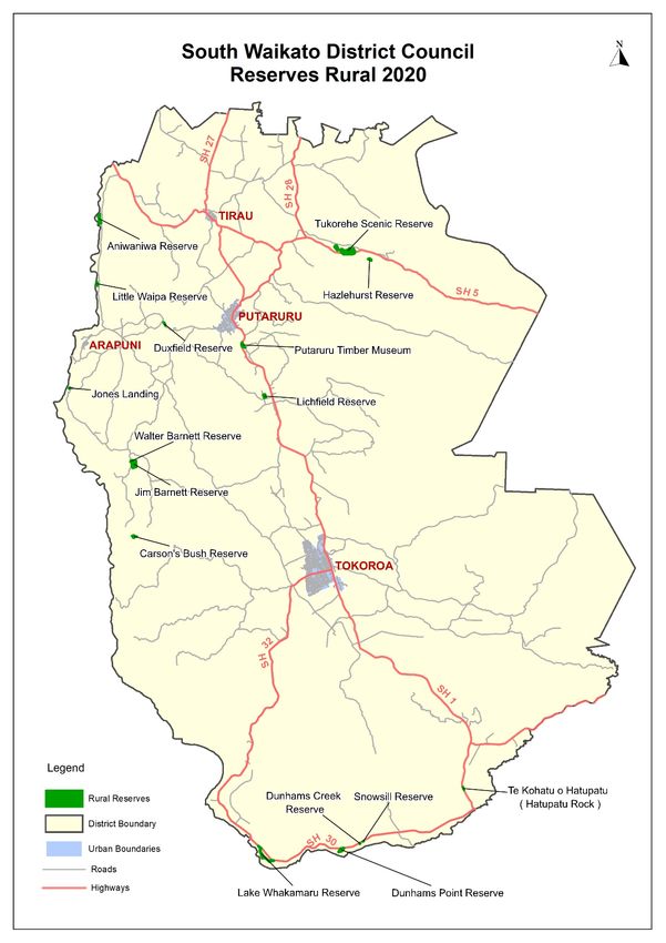
Rural Reserves
Table of Contents Page Number
Aniwaniwa Reserve 5
Carsons Bush 10
Dunham’s Creek Reserve 12
Dunham’s Point Reserve 14
Duxfield Reserve 17
Jim Barnett Reserve 20
Jones Landing 23
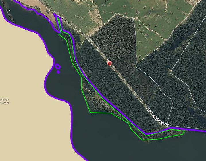
Lake Whakamaru Reserve 26
Lichfield Reserve 29
Little Waipa Reserve 32
Putāruru Timber Museum 35
Snowsill Reserve 37
State Highway 5 Scenic Reserve (Hazlehurst Bush) 39
Te Kohatu o Hatupatu (“Hatupatu Rock” site) 41
Tukorehe Scenic Reserve (Fitzgerald Glade) 45
Walter Barnett Reserve 48
3
Document Set ID: 539225
Version: 10, Version Date: 22/10/2020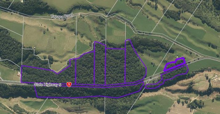
4

Document Set ID: 539225
Version: 10, Version Date: 22/10/2020
Aniwaniwa Reserve
                Location: The Aniwaniwa Reserve is located on Horahora Road on the eastern banks of
                Lake Karapiro immediately north of the Pokaiwhenua Stream.

                 Access: Access is from Horahora road which is approximately 5 km south of State
                 Highway 1.

                Portfolio Designation: Rural reserve

                Map:

                Legal Description:

                  Section/Lot:              Area (ha):                Classification under
                                                                      Reserves Act 1977 as
                                                                      referenced in the NZ
                                                                      Gazette:

                  Lot 9 DP 316754           1.1232                    Recreation Reserve

                  Section 3 SO 326117       0.2100                    N/A

                                                                                                      5

Document Set ID: 539225
Version: 10, Version Date: 22/10/2020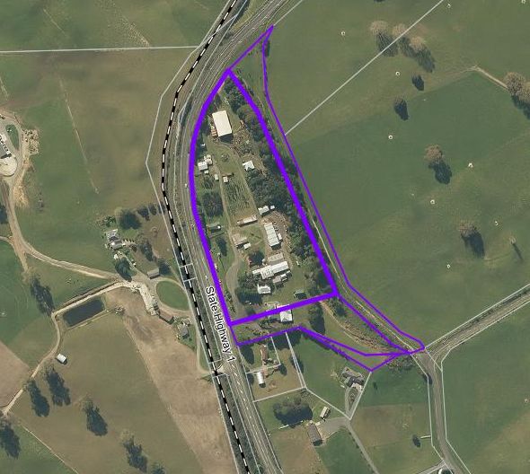
Section 4 SO 326117        8.0000                     N/A

                District Plan Zone: Rural

                Natural and Physical Features: The Reserve is situated on a flat
                to easy rolling grassed river terrace approximately 6m elevation above Lake Karapiro.
                The embankments to the lake, wetlands and stream are steep with an average 1:1 slope
                and vegetated with a mix of native and exotic species. Significant wetlands surround the
                site.
                Historical /Investment Background: Aniwaniwa Reserve was formerly known as
                Pokaiwhenua Reserve due to its location adjacent to the Pokaiwhenua Stream. The name
                change occurred in 1976 in recognition of the name Aniwaniwa appearing on old maps of
                the area. Aniwaniwa was a crossing place of the Waikato River and was used frequently
                by Maori and European settlers. The river was originally spanned by a single tree;
                subsequently a bridge was erected in 1880. The reserve later became the site of the
                Horahora Village and the now submerged Power Station lies immediately offshore from
                the reserve. The Horahora Power Station was constructed and operated by the Waihi
                Gold Company in 1913 and was the first hydroelectric power station in New Zealand. The
                station’s capacity was 6,400 kw and this was subsequently increased after government
                purchase in 1919. Horahora remained operational until it was submerged on the 4th of
                April 1947, with the flooding of Lake Karapiro. Today only a large concrete reservoir and
                scattered pieces of turbines reflect this history.

                Lot 9 (Area ‘A’ on map) was vested in Council under the Resource Management Act 1991
                as recreation reserve on the 2003 subdivision of land and is classified as a recreation
                reserve under the Reserves Act 1977. This parcel provides access to Section 4, SO
                326117 (Area ‘B’ on map). The developer of the properties on either side of the access,
                at 394 and 398 Horahora Road developed entrances to these respective properties from
                Lot 9, rather than from the legal access road on Horahora Road as per the original
                resource consent. Council has retrospectively granted the present owners right of access
                to enter and exit onto reserve land but noting that the right of access does not grant
                them legal rights to the reserve.

                Section 4 SO 326117 is still held by the Crown as Crown land subject to the Land Act
                1948 subject to a hydro lake operating easement that grants the right to store water and
                right to install and operate hydro- electricity works.

                Between 1963 and 1980 eight parcels of Crown land held for water power development
                under the Public Works Act were specifically identified on the shores of hydro lakes
                Karapiro, Arapuni, Whakamaru and Maraetai. Ready access and public demand resulted
                in these parcels, by notice in the NZ Gazette, being authorised for recreation purposes
                as a secondary use, subject to the Reserves Act. The control and management of each
                parcel was vested in the surrounding local authority.

                The authorisation for recreation purposes as a secondary use for Aniwaniwa Reserve was
                contained in the NZ Gazette in 1975.

                In 1995 with the demise of NZ Electricity Department and the establishment of State-
                owned enterprise Electricity Corporation of New Zealand (later Mighty River Power
                Limited, now Mercury NZ Ltd and others) the Crown requested that the local authority
                surrounding each of the secondary use reserves agree to that secondary use being
                uplifted. That was to enable all land comprising lake bed and margins to be declared
                Crown land under the Land Act – a preliminary step to such land being made subject to

                                                                                                        6

Document Set ID: 539225
Version: 10, Version Date: 22/10/2020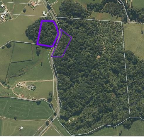
an operating easement appurtenant to the fee simple titles to the dams and power
                stations.

                The secondary use authorisation was revoked by NZ Gazette 1995 page 4795. The
                Crown (then represented by the Department of Survey and Land Information, now Land
                Information New Zealand or LINZ) gave an undertaking that following registration of the
                operating easement, the former secondary use parcels would be vested as recreation
                reserves in the District Councils.

                When Waikato River operating easements were surveyed each parcel to be subsequently
                reserved and vested was separately defined. The operating easements were registered
                in January 2011 but to date no subsequent reservation and vesting of the eight parcels
                have taken place. This includes Section 3 SO 326117, ‘Aniwaniwa Island’ (Area ‘C’ on
                map) and Section 4 SO 4 326117.

                Responsibility for that action rests with the Department of Conservation.

                Recent correspondence to Council from the Department of Conservation indicated that
                initial consultation with Iwi which DOC carried out in 2015 and 2016 in respect of vesting
                the reserves in Councils needed to be revisited, since for some sites, the Iwi requested
                to be involved more closely with reserve management.

                They advised that in the interim there is sufficient Iwi feedback to complete the first part
                of the process, that is, the setting apart as reserve and classification for recreation
                purposes, and that a further step could be a control and manage appointment to
                Councils (not a vesting).

                Under the current SWDC District Plan ‘Aniwaniwa Reserve’ refers to only part of Section
                4 SO 326117, with perimeters shown by green dash lines:

                As stated, it is LINZ’s intention for Section 4 SO 326117 to be ultimately vested to
                Council in its entirety, along with Section 3, “Aniwaniwa Island’.

                Parts of Sections 3 and 4 are designated as Significant Natural Areas within the District
                plan, shown in yellow:

                                                                                                            7

Document Set ID: 539225
Version: 10, Version Date: 22/10/2020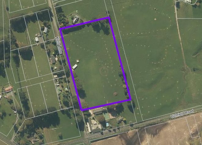
There are no classified heritage sites located within the Reserve. However, this site has
historical significance to both Maori and European settlers being an important crossing
point of the Waikato River. It is also the location for New Zealand’s first hydroelectric
power station.
Purpose, Use and User Groups: The purpose of the Reserve is to provide a large open
space for informal passive and active recreational use for the public and for the
protection of the natural environment and beauty of the countryside. Currently parts of
the reserve is grazed under lease and availability for public use is limited.
Leasee: Two leases are currently held with LINZ by adjoining landowners for
maintaining the reserve.
Reserve Management and Maintenance: The reserve is administered by Land
Information New Zealand (LINZ). Maintenance of the reserve not held under lease,
shown in map below, is managed by the South Waikato District Council:
Turf is to be cut to 75mm height with 6 cuts per year.
Future development options:
Council to continue to pursue its right to title to Aniwaniwa reserve as recreation
reserve, subject to the Reserves Act 1977;
8
Document Set ID: 539225
Version: 10, Version Date: 22/10/2020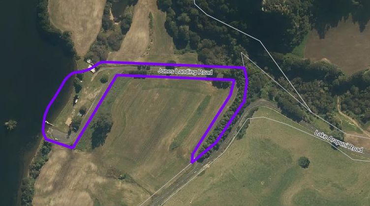
In 2008 a Landscape Concept Plan was developed for public consultation in 2009
in preparation for the Reserves Management Plan 2010. In general, local
landowners indicated support for developing the reserve with walkways and
planting and informational signage but raised concerns with the proposed boat
ramp, parking, freedom camping and toilets.
To date Council has not developed this reserve, preferring to concentrate on upgrading
the toilets, bins and providing additional shower facilities at the Little Waipa reserve.
Council has in recent years undertaken fencing works to designate correct boundary
lines.
Waikato River Trail has established a carpark on Mercury NZ land adjacent to the
reserve, and a toilet has been installed next to the trail in this area.
Waikato River Trail is currently exploring options to develop a trail through the reserve
to head northwards.
It is proposed that once the land has been vested in the South Waikato District Council
that further consultation should be made with Iwi and locals to determine the
desirability, need and extent of any proposed development, leading to a revised concept
plan being developed.
Council’s intention is to:
Install metalled walkways;
Remove Privet and other invasive pest plants and replant with New Zealand
Native species suitable for the soil conditions and climate;
Provide informational signage, including historical aspects around the former
Horahora Village site, significance and historical use of the area by Māori and the
reserve’s Significant Natural Area designation;
Provide Park furniture.
9
Document Set ID: 539225
Version: 10, Version Date: 22/10/2020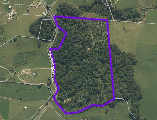
Carson’s Bush
                Location: The reserve is located on private property and can be seen from a distance
                from the end of Waotu South Road.

                Access: The reserve is land locked and not accessible to the public.

                Portfolio Designation: Rural reserve

                Map:

                Legal Description:

                  Section/Lot:               Area (ha):                  Classification under
                                                                         Reserves Act 1977 as
                                                                         referenced in the NZ
                                                                         Gazette:

                  Lot 1 DPS 24149            3.3630                      N/A

                District Plan Zone: Rural

                Natural and Physical Features: Carson’s Bush is an area of remnant cut-over forest
                containing such species as Beilschemiedia tawa (Tawa), Laurelia novae-zelandiae
                (Pukatea) and Knightia excelsa (Rewarewa). As such it provides some concept to the
                original native cover of the area.

                                                                                                       10

Document Set ID: 539225
Version: 10, Version Date: 22/10/2020
Historical /Investment Background: The reserve land was gifted to the Matamata
County Council by Mr Eric Owen Carson in 1978 in pursuance of a Deed of Covenant
dated 16 August 1977, to be held in perpetuity as a reserve.
Purpose, Use and User Groups: The purpose of the Reserve is to protect some of the
natural environment and beauty of the District.
Leasee: Not applicable.
Reserve Management and Maintenance: The reserve is administered solely by the
South Waikato District Council. No maintenance of the reserve is currently undertaken
by the South Waikato District Council; however possum control is carried out by the
Waikato Regional Council as part of their Priority Possum Control Area (PPCA) sector
known as Waotu.
Future development options:
It is recommended that the reserve be left in its current state.
11
Document Set ID: 539225
Version: 10, Version Date: 22/10/2020Dunham’s Creek Reserve
Location: The reserve is located on Ongaroto Road (SH30) and is on the foreshore of
Lake Whakamaru.
Access: Ongaroto Road (SH30) only.
Portfolio Designation: Rural reserve
Map:
Legal Description:
Section/Lot: Area (ha): Classification under
Reserves Act 1977 as
referenced in the NZ
Gazette:
Part Section 1 SO 326120 Not surveyed N/A
District Plan Zone: Rural
Natural and Physical Features: A rural style reserve, with a relatively flat area and
provides easy off-road access to the lake for swimming. There is a mobility trail and
board walk leading through a section of native bush which is the start of the section of
the River Trail between Dunham’s Creek and Dunham’s Point reserves. It is a strategic
link in the Waikato River Trail and provides a stopping off point for walkers.
Historical /Investment Background: Held by the Crown as Crown land subject to the
Land Act 1948 and subject to a hydro lake operating easement.
12
Document Set ID: 539225
Version: 10, Version Date: 22/10/2020Purpose, Use and User Groups: The purpose of the reserve is to provide an open
space for informal passive and active recreational use for the public and for travellers
and walkers along the River Trail.
Leasee: Not applicable.
Reserve Management and Maintenance: The reserve is administered by the South
Waikato District Council. Maintenance of the reserve is managed by the South Waikato
District Council.
Turf is cut to 75mm, to be cut 6 times a year, including December prior to the Holiday
period.
A 200L drum litter bin is provided.
Litter control to be maintained to an appropriate level.
Hard surfacing to be kept clean and free of weeds.
Future development options:
Continue to maintain at current levels of service;
Plant specimen New Zealand Native trees.
13
Document Set ID: 539225
Version: 10, Version Date: 22/10/2020Dunham’s Point Reserve
Location: Dunham’s Point is situated on Lake Whakamaru with access from Ongaroto
Road, approximately 42 kilometres from Tokoroa. It is located within 2 kilometres of
Snowsill and Dunham’s Creek Reserves.
Access: Ongaroto Road (SH32)
Portfolio Designation: Rural reserve
Map:
Legal Description:
Section/Lot: Area (ha): Classification under
Reserves Act 1977 as
referenced in the NZ
Gazette:
Section 5 SO 326120 5.984 N/A
District Plan Zone: Rural
Natural and Physical Features: There is an appealing entrance to the reserve with
lovely views of the river, and it is a good area for camping with large grassed areas,
planting and contours dividing it into many sites. The highway is not visible from the
reserve making it private and enhancing its appeal to the public. There is a great view of
the bluffs on the other side of the river and groups of unusual rocks in the river can also
14
Document Set ID: 539225
Version: 10, Version Date: 22/10/2020be seen. It is also a strategic link into the Waikato River Trail. It is of high scenic value
and has both boat access and direct access to a ski lane.
Historical /Investment Background: Held by the Crown as Crown land subject to the
Land Act 1948 and subject to a hydro lake operating easement.
Between 1963 and 1980 eight parcels of Crown land, including Section 5 SO 326120
(“Dunham’s Point reserve”) held for water power development under the Public Works
Act were specifically identified on the shores of hydro lakes Karapiro, Arapuni,
Whakamaru and Maraetai. Ready access and public demand resulted in these parcels,
by notice in the NZ Gazette, being authorised for recreation purposes as a secondary
use, subject to the Reserves Act. The control and management of each parcel was
vested in the surrounding local authority. The authorisation for recreation purposes as a
secondary use for Dunham’s Point was contained in NZ Gazette 1966 page 944.
In 1995 with the demise of NZ Electricity Department and the establishment of State-
owned enterprise Electricity Corporation of New Zealand (later Mighty River Power
Limited, now Mercury NZ Ltd, and others) the Crown requested that the local authority
surrounding each of the secondary use reserves agree to that secondary use being
uplifted. That was to enable all land comprising lakebed and margins to be declared
Crown land under the Land Act – a preliminary step to such land being made subject to
an operating easement appurtenant to the fee simple titles to the dams and power
stations. The secondary use authorisation was revoked by NZ Gazette 1995 page 4795.
The Crown (then represented by the Department of Survey and Land Information, now
Land Information New Zealand, or LINZ) gave an undertaking that following registration
of the operating easement, the former secondary use parcels would be vested as
recreation reserves in the District Councils.
When Waikato River operating easements were surveyed, each parcel to be
subsequently reserved and vested was separately defined. The operating easements
were registered in January 2011 but no subsequent reservation and vesting of the eight
parcels have taken place. Responsibility for that action rests with the Department of
Conservation.
Recent correspondence to Council from the Department of Conservation indicated that
initial consultation with Iwi which DOC carried out in 2015 and 2016 in respect of vesting
the reserves in Councils needed to be revisited, since for some sites, the Iwi requested
to be involved more closely with reserve management.
They advised that in the interim there is sufficient Iwi feedback to complete the first part
of the process, that is, the setting apart as reserve and classification for recreation
purposes and that a further step could be a control and manage appointment to Councils
(not a vesting).
A vault type 2 pan toilet block was installed within the reserve to replace the long drop
toilets in 2013.
In 2018/19 Council accessed funding from the Tourism Infrastructural Fund to install a
shower block, recycling bin station and an electric barbeque unit and shelter.
In 2019 a number of deteriorating mature Pines were felled, with replacement New
Zealand native and exotic trees planted in 2020.
Purpose, Use and User Groups: The purpose of the Reserve is to provide a large open
space for informal passive and active recreational use for the public, to access Lake
15
Document Set ID: 539225
Version: 10, Version Date: 22/10/2020Whakamaru, and to protect other environments in the area. Dunham’s Point has high
usage especially so during the summer months by campers and day trippers enjoying
the easy access to the river. It is also visited by walkers on their way along the Waikato
River Trail.
Leasee: Not applicable.
Reserve Management and Maintenance: The reserve is administered by the South
Waikato District Council. Maintenance of the reserve is managed by the South Waikato
District Council.
Turf is cut to 75mm, to be cut 6 times a year, including December prior to the Holiday
period.
Garden maintenance includes the maintaining of native revegetation and shrub
plantings.
Maintenance of park furniture includes to be kept in a clean and in a safe condition.
Hard surfacing to be kept clean and free of weeds.
Litter control to be maintained to an appropriate level.
Toilet cleaning to be carried out to an appropriate level as per contract.
Internal metalled road is replenished as required.
Future development options:
Council to continue to pursue its right to title to Dunham’s Point reserve as
recreation reserve, subject to the Reserves Act 1977.
Continue weed control of pest plants such as broom and blackberry within the
reserve
Continue to plant NZ native trees
Install a bicycle stand by the toilet block
Provide Informational signage, detailing significance and historical use of the area
by Māori
Improve signage messaging including information regarding freedom camping
permits.
16
Document Set ID: 539225
Version: 10, Version Date: 22/10/2020Duxfield Reserve
Location: The reserve is located on Arapuni Road, approximately 4.2 km from Putāruru
township. The entrance to the reserve is directly opposite the Arapuni Road/Pearsons
Road intersection.
Access: Arapuni Road.
Portfolio Designation: Rural reserve
Map:
Legal Description:
Section/Lot: Area (ha): Classification under
Reserves Act 1977 as
referenced in the NZ
Gazette:
N/A Not surveyed N/A
(approx.0.0356
District Plan Zone: Rural
Natural and Physical Features: The reserve is a long narrow strip of land, overlooking
the Pokaiwhenua Stream with easy access and good off-road parking. It is a very
pleasant picnic area with some native and exotic trees providing shade. The most
significant landscape features are the mature Oak tree and the waterfall which cascades
over a rock shelf and is used by kayakers. Views of the waterfall are limited due to the
pipe and wire safety barrier and steep drop into the stream.
17
Document Set ID: 539225
Version: 10, Version Date: 22/10/2020Historical /Investment Background: Road vested in the South Waikato District
Council (previously Matamata County Council) by operation of s.315 and 316, Local
Government Act 1974. To establish this parcel as reserve, a survey and road stopping is
required under the Local Government Act 1974 or the Public Works Act 1981. Section
345(3), Local Government Act or s.118, Public Works Act will apply on stopping –
provision for a recreation reserve.
The reserve was originally developed by the Putaruru Lions Club in 1973.1
In 2008 one each of Fraxinus ornus, (Ash), Acer palmatum (Maple) and Gingko biloba
(Maidenhair Tree) trees were planted in the area on the left-hand side of the driveway.
In 2013 5 Ulmus ‘Lobel’ (“Upright Elm”) trees were planted for autumnal colour on the
frontage.
The reserve has a mesh fence for safety on the stream side. A 200L litter bin is provided.
Modern signage was installed in 2018, along with a picnic table.
In 2019 the entrance and road within the reserve was regraded and re-metalled.
Purpose, Use and User Groups: The purpose of the Reserve is to provide a large open
space for informal passive and active recreational use for the public and for the
protection of the natural environment and beauty of the countryside. Currently it used
for picnicking, and as access to the Pokaiwhenua Stream for fishing.
Leasee: Not applicable.
Reserve Management and Maintenance: The reserve is administered solely by the
South Waikato District Council. Maintenance of the reserve is managed by the South
Waikato District Council.
Turf is maintained to keep the grass height between 35mm and 100mm.
Garden maintenance includes maintenance of NZ native revegetation plantings.
Maintenance of park furniture includes to be kept in a clean and in a safe condition.
Hard surfacing to be kept clean and free of weeds.
Litter control to be maintained to an appropriate level.
Internal metalled road is replenished as required.
Future development options:
Conduct survey and road stopping and classify as a recreation reserve;
Install bollarding on left side of driveway to prevent vehicle damage to turf over
winter months
Continue to maintain at current levels of service;
Provide Informational signage, detailing significance and historical use of the area
by Māori;
The adjoining landowner’s at the northern end have proposed gifting part of their
land for Council to create an extended walkway from their land through the
Council owned section of land between their property, to the strip of legal road
part of which contains “Duxfield Reserve”.
18
Document Set ID: 539225
Version: 10, Version Date: 22/10/20201 V. Scherer, “Putāruru, Home of the Owl”, page 116
19
Document Set ID: 539225
Version: 10, Version Date: 22/10/2020Jim Barnett Reserve
Location: The reserve is located on Waotu South Road.
Access: Waotu South Road.
Portfolio Designation: Rural reserve
Map:
Legal Description:
Section/Lot: Area (ha): Classification under
Reserves Act 1977 as
referenced in the NZ
Gazette:
Lot 2 DP 28078 0.7057 Scenic Reserve
Part Lot 3 DP 25793 19.6803 Scenic Reserve
District Plan Zone: Rural
Natural and Physical Features: The reserve is the only accessible example of intact
native bush in the South Waikato. The reserve is composed of modified and regenerating
forest. Facilities include a small camping area, picnic area, tap for water supply, two
composting toilets and wheelchair access through a gate near the main entry. There are
a number of maintained tracks throughout the reserve.
20
Document Set ID: 539225
Version: 10, Version Date: 22/10/2020Historical /Investment Background: Acquired under the Public Works Act 1981 by
NZ Gazette 1992-page 2904 from the Estate of James Allan Barnett. Classified and
formally named Jim Barnett Scenic Reserve subject to the provisions of s.19(1)(a),
Reserves Act 1977 by NZ Gazette 1992 page 4446.
In 1990 Council received a letter from the Late Gordon Stephenson on behalf of Mr Brian
Barnett to ascertain if Council would be interested in purchasing an area of bush
available on Waotu South Road. Council committed funding, and with funding provided
by the Forest Heritage Trust the land was purchased in 1992. One of the conditions of
purchase set by the Forest Heritage Trust was that the land be declared a scenic reserve
under the Reserves Act 1977.
During the 1920’s the forest in this area was logged for the main podocarp species, and
farm livestock subsequently had access until the reserve was established in 1992. The
vegetation was extensively modified, first by the removal of millable trees of some
species, secondly by browsing and grazing livestock, thirdly by browsing by the
introduced Brush-tailed possum (Trichosurus vulpecula). These vegetation changes
severely affected the avian assemblage with exotic mammalian predators of birds having
a further disastrous affect (all of this information was gained from a Waikato University
assignment by H Clifford “Jim Barnett Reserve- Comparison of Two Bird Survey
Methods”).
A community committee made up of members from local families, representatives from
Council, Waikato River Trails and the Waotu School looks after the reserve, along with
the Walter Barnett Reserve nearby. Gordon Stephenson was very active in encouraging
the development of this reserve, and members of the Forest and Bird Society and local
iwi have also been involved in the committee over the years. Tracks have been created,
fencing, carparking, park furniture and signage installed, pest plants eradicated, and
native trees planted to develop the reserve over time. A significant number of hours are
devoted to the reserve by volunteers who regularly undertake pest animal control with
bait stations and holding working bees throughout each year. Community Detention has
been active in doing maintenance on the reserve in past years with the Waikato River
Trails now engaged by Council to maintain the tracks within the reserve. The Waotu
School are involved with pest tracking and educational sessions in the reserve around
flora and bird life. Putāruru pre-school centres also have children coming into the reserve
weekly.
In 2018 a timber memorial shelter was installed within the picnic area.
In 2019 the timber bridges and boardwalks were re-decked as necessary.
Purpose, Use and User Groups: The purpose of the Reserve is to preserve a large
area of native bush, provide access paths and information for the enjoyment of the
public, provide a large open space for informal passive and active recreational use for
the public and for the protection of the natural environment and beauty of the
countryside.
Leasee: Not applicable.
Reserve Management and Maintenance: The reserve is administered by the South
Waikato District Council in conjunction with the Barnett Reserves Committee.
Maintenance of the reserve is managed by the South Waikato District Council (mowing,
weed-trimming, weed spraying), local volunteers (pest animal and weed control,) and
the Waikato River Trails (track maintenance).
21
Document Set ID: 539225
Version: 10, Version Date: 22/10/2020The Waikato Regional Council also undertake possum control within the reserve as part
of their Priority Possum Control Area (PPCA) sector known as Waotu.
Turf within the picnic area is to be maintained to keep grass height between 35-100mm.
Maintenance of park furniture includes to be kept in a clean and in a safe condition.
Hard surfacing to be kept clean and free of weeds.
Toilet cleaning to be carried out to an appropriate level as per contract.
Metalled tracks and carpark are replenished as required.
Future development options:
Place gravel on Gordon’s Track;
Construct steps on the steep slope where John’s Track meets Tane’s Track;
Eradicate weeds, plant and mulch the area at the end of the main parking area;
Mulch the mid area of Tane’s Track to suppress weeds and allow for picnicking;
Continue to maintain at current levels of service.
22
Document Set ID: 539225
Version: 10, Version Date: 22/10/2020Jones Landing
Location: Jones’ Landing is located on the Waikato River and is 27 kilometres west of
Putāruru.
Access: Access is gained from Lake Arapuni Road.
Portfolio Designation: Rural reserve.
Map:
Legal Description:
Section/Lot: Area (ha): Classification under
Reserves Act 1977 as
referenced in the NZ
Gazette:
Section 3 SO 326129 1.3780 N/A
District Plan Zone: Rural
Natural and Physical Features: A very attractive reserve with a large flat area of
grass along the river edge and a small hill on the northern edge of the Reserve enclosing
a small still backwater of the Waikato River. The significant rock bluffs dominate the view
to the north and emphasize the importance of the site as part of the Waikato River Trail.
This trail is of strategic importance for visitors and will be approximately 100km long
when completed. Facilities include; toilets, boat ramp, playground equipment and a
jetty. In the winter the grassed area becomes very damp. The water supply for the
toilets comes from an adjacent property.
23
Document Set ID: 539225
Version: 10, Version Date: 22/10/2020Historical /Investment Background: The reserve was originally developed as a
combined project between the Matamata County Council and the Putaruru Jaycees in
1969 to build a boat ramp and toilet block.1
Held by the Crown as Crown land subject to the Land Act 1948 and subject to a hydro
lake operating easement.
Between 1963 and 1980 eight parcels of Crown land, including Section 3 SO 326129
(“Jones Landing”) held for water power development under the Public Works Act were
specifically identified on the shores of hydro lakes Karapiro, Arapuni, Whakamaru and
Maraetai. Ready access and public demand resulted in these parcels, by notice in the NZ
Gazette, being authorised for recreation purposes as a secondary use, subject to the
Reserves Act. The control and management of each parcel was vested in the
surrounding local authority. The authorisation for recreation purposes as a secondary
use for Dunham’s Point was contained in NZ Gazette 1966 page 944.
In 1995 with the demise of NZ Electricity Department and the establishment of State-
owned enterprise Electricity Corporation of New Zealand (later Mighty River Power
Limited, now Mercury NZ Ltd, and others) the Crown requested that the local authority
surrounding each of the secondary use reserves agree to that secondary use being
uplifted. That was to enable all land comprising lakebed and margins to be declared
Crown land under the Land Act – a preliminary step to such land being made subject to
an operating easement appurtenant to the fee simple titles to the dams and power
stations. The secondary use authorisation was revoked by NZ Gazette 1995 page 4795.
The Crown (then represented by the Department of Survey and Land Information, now
Land Information New Zealand, or LINZ) gave an undertaking that following registration
of the operating easement, the former secondary use parcels would be vested as
recreation reserves in the District Councils.
When Waikato River operating easements were surveyed, each parcel to be
subsequently reserved and vested was separately defined. The operating easements
were registered in January 2011 but no subsequent reservation and vesting of the eight
parcels have taken place. Responsibility for that action rests with the Department of
Conservation.
Recent correspondence to Council from the Department of Conservation indicated that
initial consultation with Iwi which DOC carried out in 2015 and 2016 in respect of vesting
the reserves in Councils needed to be revisited, since for some sites, the Iwi requested
to be involved more closely with reserve management.
They advised that in the interim there is sufficient Iwi feedback to complete the first part
of the process, that is, the setting apart as reserve and classification for recreation
purposes and that a further step could be a control and manage appointment to Councils
(not a vesting).
Throughout the 1980’s and 90’s the jetty, seats and picnic tables were installed.
From 2006 to 2008 the jetty and litter bins were upgraded, and a slide and swings were
installed.
In 2014 to 2016 the swings were replaced, and a gas barbecue unit and associated
picnic seats were installed.
24
Document Set ID: 539225
Version: 10, Version Date: 22/10/2020In 2018/19 Council accessed funding from the Tourism Infrastructural Fund to install a
shower block, recycling bin station and an electric barbeque unit and shelter. The Park
name sign was also replaced with modern signage.
Purpose, Use and User Groups: The purpose of the Reserve is to provide a large open
space for informal passive and active recreational use for the public and access to the
Waikato River. It is a popular site for campers and boaties in the summer and the long
weekends. The inland location of the South Waikato and the distance from the coast
makes access to the rivers and lakes in the district important for recreational use for
residents.
Leasee: Not applicable.
Reserve Management and Maintenance: The reserve is administered by the South
Waikato District Council. Maintenance of the reserve is managed by the South Waikato
District Council.
Turf is cut to 75mm, to be cut 6 times a year, including December prior to the Holiday
period.
Garden maintenance includes the maintaining of New Zealand native revegetation
plantings.
Maintenance of park furniture includes to be kept in a clean and in a safe condition.
Hard surfacing to be kept clean and free of weeds.
Litter control to be maintained to an appropriate level.
Toilet cleaning to be carried out to an appropriate level as per contract.
Future development options:
Council to continue to pursue its right to title to Jones Landing as recreation
reserve, subject to the Reserves Act 1977;
Improve signage messaging including information regarding freedom camping
permits;
Provide Informational signage, detailing significance and historical use of the area
by Māori;
Continue to maintain at current levels of service.
1 V. Scherer, “Putāruru, Home of the Owl”, page 116.
25
Document Set ID: 539225
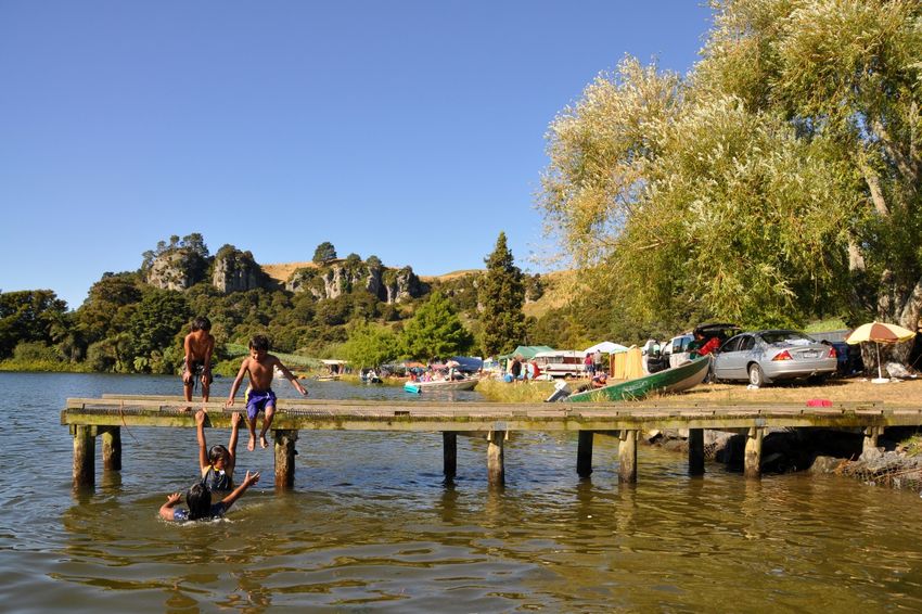
Version: 10, Version Date: 22/10/2020Lake Whakamaru Reserve
Location: The reserve is a long narrow strip of land between Ongaroto Road and the
Waikato River,near the Whakamaru Dam.
Access: Ongaroto Road (SH32)
Portfolio Designation: Rural reserve
Map:
Legal Description:
Section/Lot: Area (ha): Classification under
Reserves Act 1977 as
referenced in the NZ
Gazette:
Part Section 1 SO 14.3749 N/A
326120
District Plan Zone: Rural
Natural and Physical Features: The reserve provides limited but attractive access to
the Waikato River. There is a boat ramp at the northern end, and a small beach area at
the southern end of the reserve. It has a number of open grassed areas for camping and
is used extensively by campers over the summer. It provides another strategic link in
the Waikato River Trails walkway.
26
Document Set ID: 539225
Version: 10, Version Date: 22/10/2020Historical /Investment Background: Held by the Crown as Crown land subject to the
Land Act 1948 and subject to a hydro lake operating easement for a right to store water
and right to install and operate hydro- electricity works.
Between 1963 and 1980 eight parcels of Crown land held for water power development
under the Public Works Act were specifically identified on the shores of hydro lakes
Karapiro, Arapuni, Whakamaru and Maraetai. Ready access and public demand resulted
in these parcels, by notice in the NZ Gazette, being authorised for recreation purposes
as a secondary use, subject to the Reserves Act. The control and management of each
parcel was vested in the surrounding local authority. However, there is no record in
Landonline of Lake Whakamaru Reserve being identified for such secondary use.
The reserve was formerly known as the Carter Holt Harvey Recreation Area
(Whakamaru). The land consists of some Crown land under Land Information New
Zealand (LINZ) administration but subject to an operating easement in favour Mercury
New Zealand Ltd. This easement is the predominant use of the land and any other uses
is secondary. Carter Holt Harvey also owns some land within the reserve. Since 2001 the
South Waikato District Council has managed and maintained the reserve. A lease
application is currently still to be approved by LINZ. Recently Colliers International, who
act as agent for LINZ, have confirmed their recommendation to LINZ has been finalised,
and have advised that LINZ has to do iwi consultation on all applications adjacent the
Waikato River Lakes as part of considering Council’s request.
In 2012 the various long-drop toilets were removed, and two 2 pan vault type toilet
blocks installed within the reserve.
In 2019, with approval from LINZ the aging Pine trees within the reserve were felled due
to concerns with public safety. Post harvesting removal of slash was completed with
remaining debris placed into piles to break down over time. Ground remediation works
including levelling and reseeding was carried out and replacement quicker growing exotic
tree species were planted within the main camping areas, in order to provide shade. New
Zealand native trees were also planted predominantly within the non-camping areas, and
around the debris pile perimeters, with further planting to be carried out as the debris
breaks down over time to become native “islands” within the camping areas.
Purpose, Use and User Groups: The purpose of the Reserve is to provide a large open
space for informal passive and active recreational use for the public and to allow access
to the Waikato River. It has high use in the summer by campers, boaties and day visitors
for picnics.
Leasee: Not applicable.
Reserve Management and Maintenance: The reserve is managed by the South
Waikato District Council. Maintenance of the reserve is managed by the South Waikato
District Council.
Turf is cut to 75mm, to be cut 6 times a year, including December prior to the Holiday
period.
Garden maintenance includes the maintaining of New Zealand native revegetation
plantings.
Maintenance of park furniture includes to be kept in a clean and in a safe condition.
27
Document Set ID: 539225
Version: 10, Version Date: 22/10/2020Hard surfacing to be kept clean and free of weeds.
Litter control to be maintained to an appropriate level.
Toilet cleaning to be carried out to an appropriate level as per contract.
Metalled roads to be replenished as required.
Future development options:
Once a lease agreement has been approved by LINZ Council intends with the
support of Tourism Infrastructure Funding if granted, to install a shower block,
replacement picnic tables, barbeque units with shelters and recycling bin stations
within the reserve. Mercury NZ and Raukawa have indicated support to complete
this work;
Continue to plant New Zealand native tree species within the non-camping areas
of the reserve;
Improve signage messaging including information regarding freedom camping
permits;
Install bicycle stand by the toilet blocks;
Provide Informational signage, detailing significance and historical use of the area
by Māori;
Continue to maintain at current level of service.
28
Document Set ID: 539225
Version: 10, Version Date: 22/10/2020Lichfield Reserve
Location: Lichfield Reserve is located on Kells Lane in Lichfield, next to the Lichfield
Primary School.
Access: Public pedestrian access is from the Lane, through the carpark provided on the Reserve.
Vehicular access is available in two places along Kells Lane. School access to the Reserve is from the
rear of the school property, through the hall site.
Portfolio Designation: Rural reserve
Map:
Legal Description:
Section/Lot: Area (ha): Classification under
Reserves Act 1977 as
referenced in the NZ
Gazette:
Section 26 Block XV, 4.3706 Recreation Reserve
Patetere North Survey
District
District Plan Zone: Rural
Natural and Physical Features: The Lichfield Reserve has an ‘English Pastoral
Landscape Character’ derived from the significant plantings of large deciduous trees from
the northern hemisphere such as the oaks and the grassed open space and adjacent
29
Document Set ID: 539225
Version: 10, Version Date: 22/10/2020pasture. There is an historic cultural overlay as some of the trees planted in memory of
the soldiers who died in World War One and remnants of the early settlement in the form
of light standards remain on site but are not used. These elements reinforce the English
pastoral landscape character of the Domain. Adding to the pastoral character of the site
is the view obtained from the road which is framed and filtered by the canopy of the oak
trees to the open space and adjacent farmland. Of moderate visual appeal the land is flat
and gentle rolling pasture. On the Reserve’s north-west corner is the South Waikato
Pony Club building and storage shed. A car parking area is situated on the south-west
side of the Reserve and is also used as parking for the school and associated hall use.
The South Waikato District Council retains responsibility for maintenance of the carpark.
Boundary planting is a special feature with its mix of exotic and indigenous tree species.
The row of trees starting at the northern end of the school consists of a large oak
(Quercus robur) in the car park and from here northwards are maple (Acer) species,
Platanus x acerifolia (London Plane), large Poplar species, Aesculus (Chestnut) ,
Podocarpus totara (Totara) and a Walnut (Juglans) tree. Trees located along the eastern
boundary of the Reserve include Salix matsudana 'Tortuosa' (Tortured Willow), Maple
species, Cedrus deodara (Himalayan Cedar), Prunus species, Chinese Fir (Cunninghamia
lanceolata), Betula pendula (Silver birch), Thuja, Gingko biloba ( Maidenhair tree), and
Cryptomeria japonica ‘Elegans’(Japanese Cedar).
Historical /Investment Background:
Originally part of Crown owned Selwyn Settlement, Section 26 was set apart as
recreation reserve by NZ Gazette 1907 page 3124. The reserve was made subject to the
Public Domains Act 1881 by NZ Gazette 1907 page 3325 and local people domain boards
were appointed as the Lichfield Domain Board down through the decades until
management passed to the District Council under The Local Government (Waikato
Region) Reorganisation Order 1989 – NZ Gazette 1989 page 2460. The first Domain
Board was appointed to have control of the Lichfield Domain in 1946 (New Zealand
Gazette page 120). The first meeting of the Board was held on the 4 February 1946 in
the Lichfield Public Hall.
The Reserve is owned by the Department of Conservation but is administered by the
South Waikato District Council. Therefore, Council’s interest from 1989 is only that of
holder of an appointment to control and manage.
The earliest mention of Lichfield and surrounding District is found in the records of the
Piako County Council which details how the Patetere Block had been to the Native Land
Court numerous times. The land Lichfield was developed on was originally owned by
local Maori and bought by the Matarawa Land Company who owned all the land between
Cambridge and Taupo. Nancy Sneddon, a prominent Lichfield local, states that an old
Maori of the District told her that the Matarawa Land Co. bought the land from the
Maoris for blankets, and poor ones at that. At this time, Lichfield was then a wilderness
of Manuka, Tawheri and Tussock and used as a staging post. The water tower was used
to fill the trains which travelled to Mokai. In 1879 the Thames Valley Land Company
(TVLC) negotiated for the purchase of the land and in 1883 it was transferred to them
for £230,000. Land transfer plans of the town of Lichfield were set down in 1884 and
included a large township and cathedral square. The land was purchased by the Crown in
1905 from the TVLC under the Lands for Consolidation Act 1900 due to the company
going into liquidation. This land became known as the Selwyn Settlement and was cut
into smaller holdings which included the Lichfield Domain. One quarter of the area was
set aside as a forest reserve. The Reserve used to be one of the biggest cycling grass
30
Document Set ID: 539225
Version: 10, Version Date: 22/10/2020velodromes in New Zealand, second to Cooks Gardens in terms of quality; in fact, the
remains of the old light posts are still there but are not in use. The original Post Office
which used to be part of Miss Kell’s Cottage was situated across from the school. The
Reserve was originally used for community activities such as calf days, church services
and jubilee celebrations. Picnics were also a common occurrence with shade provided by
the numerous oak trees. Nowadays, any special event in Lichfield incorporates the use of
the Reserve in conjunction with the Community Hall which is situated along side it. A
native bush area within the Lichfield Reserve has been developed with the financial
assistance of the Lichfield School.
Purpose, Use and User Groups: The South Waikato Pony Club uses the Reserve for
meetings, dressage events and practices. The Reserve also houses their clubrooms.
Their season begins mid-September and ends in April. During this the Reserve is used 3-
4 times a month for practicing. Occasionally Timberlands, the PPC parent club, and PPC
hold events on the Reserve whereby a ground hire charge is ascertained.
Lichfield Primary School use the Reserve daily during the school term for athletics,
sporting and recreational activities and as their playing fields
The community in general have access to the Reserve for picnics or recreation.
Leasee: Any lease over the Reserve must be by way of concession in terms of Section
59A of the Reserves Act 1977 and in accordance with Part 3B of the Conservation Act
1987.
The South Waikato Pony Club lease an area on which they have erected their own
storage shed. The grounds are also subject to ground hire charges for occasions such as
Pony Club events whereby they pay on a fee per horse basis. These charges are set by
the South Waikato District Council.
The Reserve is leased for grazing livestock by the adjoining Landowner which helps with
maintenance; the lessee also mows the part of the Reserve that is in use by the School.
Reserve Management and Maintenance: The reserve is administered by the South
Waikato District Council. Maintenance of the reserve is managed by the South Waikato
District Council under a lease agreement with the adjoining farmer.
Council maintains the carpark area, hard surfacing to be kept clean and free of weeds.
Future development options:
• Plant additional trees in gaps and continue planting of trees on the Kells Lane
boundary to help retain the landscape character of the reserve;
• Plant additional trees further along the eastern boundary;
• Consider installing fitness equipment around the perimeter of the reserve;
• Conduct aboricultural assessment of existing mature trees and undertake
required tree works accordingly;
• Seek the vesting of the reserve to the South Waikato District Council by the
Department of Conservation;
• Continue to maintain at current level of service.
31
Document Set ID: 539225
Version: 10, Version Date: 22/10/2020Little Waipa Reserve
Location: The reserve is on the Waikato River and is currently the northern most point
of the Waikato River Trail.
Access: Access can be gained from Horahora Road.
Portfolio Designation: Rural Reserve
Map:
Legal Description:
Section/Lot: Area (ha): Classification under
Reserves Act 1977 as
referenced in the NZ
Gazette:
Sections 2 and 15, Block 1.9246 Recreation Reserve
VIII,
Maungatautari Survey
District
32
Document Set ID: 539225
Version: 10, Version Date: 22/10/2020District Plan Zone: Rural
Natural and Physical Features: There is good access to a small sandy beach on the
river edge and a boat ramp. It has an open area that can be used for camping and has
an English park-like ambiance with specimen trees providing shelter. The access road is
metalled.
Historical /Investment Background: Little Waipa Reserve is one of the first areas of
park land acquired by the Matamata County Council in 1960 for the sum of £402 . It
reflects how the then County Council viewed the importance of retaining and protecting
areas of land for public use. Section 2 was set apart by the Crown as recreation reserve
by NZ Gazette 1960-page 1992 with the Matamata County Council appointed to control
and manage by NZ Gazette 1960-page 1989, as a public domain. Section 15 was road,
stopped by the Crown and added to the domain by NZ Gazette 1969 page 779.
Both parcels were classified for recreation by NZ Gazette 1980-page 2412 [Instrument
H303339] and by operation of s.26A, Reserves Act the reserves vested in the County
Council. The County Council was declared a former authority and the reserves vested in
the District Council under The Local Government (Waikato Region) Reorganisation Order
1989.
In 2008 200L bins were installed within the reserve.
In 2012 the two long-drop toilets were replaced with a vault type 2 pan toilet block, and
the sign at the entrance on Horahora Road was replaced with more modern and larger
sign board.
In 2016 a gas barbeque unit and two picnic tables were installed in the middle of the
reserve.
In 2018/19 through Tourism Infrastructure Fund funding an additional barbeque unit and
shelter, a shower block and recycling bins were installed within the reserve.
In recent years specimen exotic trees have been planted within the reserve to provide
additional shade for users.
Purpose, Use and User Groups: The purpose of the Reserve is to provide a large open
space for informal passive and active recreational use for the public and for the
protection of the natural environment and beauty of the countryside. It is a popular site
for campers and boaties in the summer and is the most frequented reserve on the
Waikato River Trails.
Leasee: Not applicable.
Reserve Management and Maintenance: The reserve is administered solely by the
South Waikato District Council. Maintenance of the reserve is managed by the South
Waikato District Council.
Turf is cut to 75mm, to be cut 6 times a year, including December prior to the Holiday
period.
Garden maintenance includes the maintaining of shrub gardens and New Zealand native
revegetation plantings.
Maintenance of park furniture includes to be kept in a clean and in a safe condition.
Hard surfacing to be kept clean and free of weeds.
33
Document Set ID: 539225
Version: 10, Version Date: 22/10/2020Litter control to be maintained to an appropriate level.
Toilet cleaning to be carried out to an appropriate level as per contract.
Metalled roads to be replenished as required.
Future development options:
• Consider sealing the section of road in from Horahora Road to the reserve
entrance;
• Improve signage messaging including information regarding freedom camping
permits;
• Provide Informational signage, detailing significance and historical use of the area
by Māori;
• Install bicycle stands by the toilet block;
• Provide a metalled carparking area at the Arapuni end of the reserve;
• Replace timber railing at entrance with timber bollards when due for replacing to
improve visibility;
• Continue to maintain at current level of service.
34
Document Set ID: 539225
Version: 10, Version Date: 22/10/2020Putāruru Timber Museum
Location: The Museum site is located off State Highway 1 approximately 1.3 km’s south
of Putāruru.
Access: Access can be gained from State Highway One.
Portfolio Designation: Rural reserve
Map:
Legal Description:
Classification under Reserves Act
1977 as referenced in the NZ
Section/Lot Area (ha) Gazette:
Local Purpose (community buildings)
Part Lot 6 DP 19039 3.8807 Reserve
Local Purpose (community buildings)
Lot 1 DP 35861 0.8944 Reserve
35
Document Set ID: 539225
Version: 10, Version Date: 22/10/2020Local Purpose (community buildings)
Section 1 SO 61757 1.1186 Reserve
Local Purpose (community buildings)
Section 1 SO 446059 0.1321 Reserve
District Plan Zone: Rural
Natural and Physical features:
Historical /Investment Background: The timber museum was established near
Putaruru in 1972, to celebrate, record, and preserve the history of the timber industry,
particularly in the South Waikato District. A small but passionate and dedicated group,
the Timber Museum Society, supported by the District Council and local industry
developed and managed the site until 2007. In that year the Timber Museum of New
Zealand Trust took over from the Society.
The Trust is working on the expansion and upgrading of this valuable resource, to tell
the stories of the primeval native rain forest prior to colonisation; the harvesting and
milling of much of that forest; and the rise of the plantation forest industry in New
Zealand as supplies of native wood ran out.
Logging the rich native forests of the South Waikato District was made inevitable by
completion of two railway tracks: the Frankton to Rotorua branch line across the
Mamaku Range in 1894, and the Taupo Totara Timber Company (TTT) 80 km
private light railway from Putaruru to Mokai in 1903. At the time, the TTT rail bridge over
the Waikato River at Ongaroto was believed to be the longest single-span wooden
suspension bridge in the world. The museum has a model of the bridge, scaled from
original plans. The museum is the repository of several historic buildings, which now
house displays or have supporting functions.
The museum is on the site of an early plantation -pine sawmill which by 1972 was empty
and derelict but has since been refurbished and partly re-equipped.
A representative grove of young native forest is growing on the site, thanks to the late
Tony Nooyen's extraordinarily generous commitment to gathering, raising and planting
the trees for over 30 years. The grove is named in Mr Nooyen’s honour.
Purpose, Use and User groups: Main users are locals, tourists and local community
based groups.
Reserve Management and maintenance: The Timber Museum site is managed and
maintained by The Timber Museum Trust of New Zealand under contract to the South
Waikato District Council.
Turf, garden, park furniture and hard surfacing maintenance is undertaken to
performance measures as stated in the SWDC District Reserves Management Plan-
Governance document.
Lessee: A lease agreement is in place with The Timber Museum Trust of New Zealand.
Future development options:
Upgrade garden areas with new plantings.
36
Document Set ID: 539225
Version: 10, Version Date: 22/10/2020You can also read