District Disaster Management Plan - Satara DDMP - Satara - District Disaster Management Authority - Satara
←
→
Page content transcription
If your browser does not render page correctly, please read the page content below
District Disaster Management Plan – Satara
                         DDMP – Satara

          District Disaster Management Authority – Satara

         Collector Office Satara, Telephone : 02162-232175,232750

D:/DDMP/DMP Satara.doc                                              Page 1
District - Satara

                                              Introduction

           As a part of the overall preparedness of the state, the Government of Maharashtra has a
State Disaster Management Action Plan to support and strengthen the efforts of the district
administration. In this context, every district has devolved its own District Disaster Management
Action Plan (DDMAP). It is expected that these multi-hazard response plans would increase the
effectiveness of administrative intervention.

Multi-disaster Response Plan

The DDMAP addresses the districts’ response to disaster situations such as earthquakes, floods,
cyclones, epidemics, off-site industrial disasters and roads accidents and fires. Some of these disasters
such as floods and earthquakes affect large areas causing extensive damage to life, property and
environment while others such as epidemics only affect large populations. In any case, the
management of these disasters requires extensive resources and manpower for containment by
remedial action.

The present plan is a multi-hazard response plan for the disasters and outlines the institutional
framework required for managing such situations. However, the plan assumes a disaster specific form
in terms of the actions to be taken by the various agencies involved in the disaster. The front-end or
local level of any disaster response organization will differ depending upon the type of disaster, but at
the level of the back-end i.e., at the controlling level at the district it will almost remain same, for all
types of disasters.

Objectives

The objectives of the District Disaster Management Action Plan are :

· To improve preparedness at the district level, through risk and vulnerability analysis , to disasters and
to minimize the impact of disasters in terms of human, physical and material loss.

· To ascertain the status of existing resources and facilities available with the various agencies
involved in the management of disasters in the district and make it an exercise in capability building of
district administration. This enables the district to face a disaster in a more effective way and builds
confidence across different segments of society. It will be a positive factor for long term development
of the district.

· To utilize different aspects of disaster mitigation for development planning as a tool for location and
area specific planning for development in the district.

· To use scientific and technological advances in Remote Sensing, GIS etc. in preparation of this plan
with a view to ensure their continuous use for development planning.

D:/DDMP/DMP Satara.doc                                                                         Page 2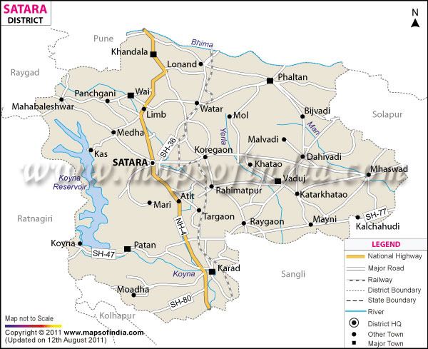
· To develop a framework for proper documentation of future disasters in the district, to have an
update on critical information essential to a plan, to critically analyze and appraise responses and to
recommend appropriate strategies

· To evolve DDMAP as an effective managerial tool within the overall policy framework of
Government of Maharashtra.

Response to disasters, in the absence of a defined plan, would be arbitrary leading to overemphasis of
some actions and absence of other actions which could be critical. The objectives of any disaster
management plan should be to localise a disaster and to the maximum extent possible contain it so as
to minimise the impact on life, the environment and property. A formal plan for managing disasters is
therefore necessary. This would include

a. pre-planning a proper sequence of response actions

b. allocation of responsibilities to the participating agencies,

c. developing codes and standard operating procedures for various departments and relief agencies
involved.

d. inventory of existing facilities and resources

e. mechanisms for effective management of resources

f. co-ordination of all relief activities including those of NGOs to ensure a coordinated and effective
response.

g. Co-ordination with the State response machinery for appropriate support

h. Monitoring and evaluation of actions taken during relief and rehabilitation

"Outline of Vulnerability Assessment" prepared by CSSD/EMC has been used as the basic instrument
to collate district level information to meet the database requirements for the preparation of DDMAP.

Policy Statement

The underlying policy of the DDMAP is to protect life, environment and property while ensuring
mitigation of the disaster to the maximum extent possible, relief to those affected and restoration of
normalcy at the earliest.

Essentially, communities draw their support from the social institutions, administrative structure, and
values and aspirations they cherish. Disasters may temporarily disorganise the social units and the

D:/DDMP/DMP Satara.doc                                                                    Page 3

administrative system and disrupt their lives built around these values and aspirations. A systematic
effort to put back the social life on its normal course with necessary technology support and resources
will contribute significantly to the resilience of the community and nation.

This policy forms the basis of the DDMAP strategy. It aims at capacity building and prompt utilization
of resources in a disaster situation through a partnership of the GOM, NGOs, Private Initiatives and
the community. In pursuance with this policy, DDMAP addresses itself to strengthening the pre-
disaster and post-disaster responses of various actors and stakeholders including the “victims” of the
disaster.

                           OVERVIEW OF SATARA DISTRICT

Location

· Satara district is located in the south western part of the state of Maharashtra and lies between 17.5°
to 18.11°North Latitudes and 73.33° to 74.54° East Longitudes.

· It is bounded on the north by Pune, on the south by Sangli, on the west by Ratnagiri, on the north-
west by Raigad, and on the east by Solapur district of Maharashtra state.

· The district headquarters Satara is well connected to the state Capital Mumbai ( 260 km to the north
west), and the major towns of Pune and Kolhapur by the Mumbai Bangalore National Highway No. 4.

· Satara is also well connected to other districts of Maharashtra by State highways and other roads.

· There is one railway line -Mumbai to Kolhapur- which passes through Satara district. The total
distance in satara district is 124 KM.

Area and Administrative Divisions

· The whole state of Maharashtra is divided into six revenue divisions ; Pune, Konkan, Nashik,
Aurangabad, Amravati, and Nagpur. Satara district is part of the Pune division along with the districts
of Pune, Sangli, Kolhapur and Solapur.

· Satara district covers an area of 10480 sq. km. with an east west expanse of 135 km and a north south
expanse of 112 km.

· The district is divided into seven Sub Division and eleven administrative sub units (tahsils) - Satara,
Wai, Khandala, Koregaon, Phaltan, Khatav, Man, Karad, Patan, Jawali and Mahabaleshwar.

D:/DDMP/DMP Satara.doc                                                                      Page 4
Sr. No. Sub-Division Tahsils incorporated in them
1 Satara Satara and Javali
2 Koregaon Koregaon
3 Wai Wai, Khandala, & Mahabaleshwar
4 Phaltan Phaltan
5 Man (Dahiwadi) Man (Dahiwadi) and Khatav
6 Karad Karad
7 Patan Patan
Salient Physical Features and Land Use Patterns
· The district has three natural sub-divisions based on the topographical situations - Hilly area in the
west, plains of the Krishna river in the central part, and the plateau area in the east.
· Mahabaleswar is the highest place in the district and is located at a height of 1466 m above mean sea
level.
Soil
· Black cotton soil is the predominant soil type found here as is the case with most of the districts on
the Deccan Plateau.
· Lateritic soil covers many parts of the western tahsils of Mahabaleshwar, Javali, Wai and Patan, is
typicaly clayey in nature and reddish in colour.
· Black cotton soil is found in the central part of the district.
· Soil fertility is especially high in the valleys of the rivers Krishna, Venna, Kudali, Koyna and Kole.
· In Khandala and Phaltan tahsils, the soil has low fertility and is rocky except for the area along the
Nira river and it’s tributaries.
Land Use Patterns
Inhabited Area : 234 sq. km.
Agricultural Area : 7203km²
Industrial Area :
Forest Cover : 1589km²
D:/DDMP/DMP Satara.doc Page 5Wastelands : 783km²
Drought prone areas : 2300km²
· Agriculture is the main land use in the district with more than 75% of the total area being used for
agricultural activities.
· Forest cover is more in the western part of the district - evergreen forests have been identified on the
western extremities.
Climate and Rainfall
Climate
· The climate in general is moderate with temperatures during the summer months (March to mid
June) reaching a maximum of 34°C, and in the winter months (November to March) dropping to 10°C.
· In the western part, the climate is pleasant during the summer, but is very cold during the monsoon.
· In the plains, the climate is moderate throughout the year.
Rainfall
· The monsoon period starts in the month of June with the maximum precipitation in July and August.
Average rainfall is 918.8 mm although there are large differences in the amount of precipitation over
various parts of the district.
¨ The Sahyadri hill ranges -chiefly in Mahabaleshwar tahsil -in the western extremity receive more
than 6000 mm. Patan and Jawali tahsils also have rainfall in excess of 2000 mm.
¨ Moving eastwards the rainfall amount drops to less than 900 mm in the tahsils of Koregaon, Karad,
Satara.and to less than 600 mm in the tahsils of Man, Khatav, Phaltan and Khandala
No. Taluka Avg. 2008 2009 2010 2011 2012 2013
Rainfall Actual Actual Actual Actual Actual Actual
(As per Rainfall Rainfall Rainfall Rainfall Rainfall Rainfall
IMD )
1 Satara 908.8 722.5 909.1 1011.2 777.6 686.0 1182.8
2 Jawli 1603.0 1502.0 1448.1 1530.1 1737.2 1258.8 1787.0
3 Koregaon 642.6 537.4 761.1 904.2 497.4 360.6 596.0
4 Karad 632.1 807.9 731.0 872.8 593.6 550.6 569.5
D:/DDMP/DMP Satara.doc Page 65 Patan 1733.0 1251.0 1179.1 1511.2 1804.6 1574.4 1510.3
6 Phaltan 382.0 339.0 835.0 1028.4 342.2 267.1 469.0
7 Man 442.8 433.1 787.0 761.5 225.8 269.0 407.2
8 Khatav 415.0 374.2 879.7 814.6 373.1 273.4 574.9
9 Wai 710.3 797.0 905.2 1029.0 873.2 650.1 881.4
10 Mahableshwar 2223.0 5660.4 4203.0 4244.0 6456.8 3908.7 3812.0
11 Khandala 416.0 439.8 562.8 662.3 733.8 451.0 633.2
Total Avg. 919.0 1169.5 1200.1 1306.3 1283.2 931.8 1129.4
Flood Prone Area : Patan, Karad, Wai and Satara Taluka are the flood prone in the district.
Following are the Details of flood prone villages in the district
No. Name of the Name of the Taluka Name of village
Dam River
1 Koyna Koyna Patan Helwak, Goshatwadi, Marul Tarf Patan,
Shiral, Yerad, Gunjali, Kaloli, Patan,
Tripudi, Aadhul, Mandrul Haveli,
Sangwad, paprde, Nisre, Nawdi, Vihe (
Toal – 16 )
2 Koyna Morna Patan Gokul, Dhawde, Abrang, Peth
Shivapur, Wadi kotawde, Morgiri,
Doglewadi, Satewadi, Dhakalwadi,
Natoshi, Kusawde, Aaddev,
Shindewadi, Sulewadi, Amrule,
Belawde, Chopdi ( Total : 17 )
3 Koyna Koyna Karad Sajur, Mohpre, Sakurdi, Sakurdiwasti,
Tambve, Supne, kirpe, Yerawle, Padali
kese, Chachegaon, Warunji, Karad (
Total – 13 )
4 Dhom Krushna Karad Kalgaon, Perle, Kharate, Bhuyachiwadi,
Kawthe, Wadawli bhikeshwar, Korti,
Umbraj, Konegaon, Shiwde, Belawde
Haveli, Wahgaon, Ghonshi, Nadshi,
Koparde Haveli, Khodshi, Saidapur,
Gote, Karad, Goware, Sayapur,
Tembhu, Koregaon, Kawre, Shere,
Dushere, Gondi, Goleshwar, Kapil,
Kodoli, Aatke, Rethre Bk., Rethre
Khurd, Malkhed, Khubi ( Total – 35 )
5 Tarli Tarli Karad Pal, Shirgaon, Wadgaon Umbraj,
Indoli, Hingnoli, Bhoslewadi, Umbraj (
total – 7 )
6 Dhom Krushna Wai Dhom, Bhogaon, Menawli, Songirwadi,
D:/DDMP/DMP Satara.doc Page 7Siddhnathwadi, Wai, Kadegaon, Aasle,
Bhuinj, Chindhwli, Pachwad, Khadki (
Total – 12 )
7 Mahu Hatgeghar Kudal Wai Kalamb and Udtare ( Total – 2 )
8 Dhom balakwadi Krushna Wai Golegaon, Golewadi, Gulumb,
Nandgani, Waygaon, ( Total – 5 )
9 Kanher Venna Satara Wadhe, Khed, Sangam mahuli,
10 Dhom Krushna Satara Limb, Mardhe, Gove, Aarle, waduth,
Patkhal, Sangam mahuli, Mahagaon,
Gojegaon, Kameri, Wenegaon,
Nandgaon, Koparde, Kashil ( Total – 14
)
11 Urmodi Urmodi Satara Parali, Ambawde, Bhondawade,
Gazawdi, Dabewadi, Sonawdi,
Ambawde khurd, Pogarwadi, Shahapur,
Zarewadi, Upli, Songaon, Shelkewadi,
Shivajinagar, Vechle, Nagthane ( Total
– 16 )
12 Dhom Krushna Koregaon Tandulwadi, Kathapur, Dhamner,
Takle, Targaon, ( Total – 5 )
13 Wasna Koregaon Jalgaon, Pimpode khurd, Amabvde (
Total – 3 )
14 Wangna Koregaon Tadawle, Koregaon, Khed, Hivre (
Total – 3 )
15 Veer Nira Khandala Ving, Kamblewasti, Pansarewasti, Loni,
Tondal, Wathar Bk, Rui, Pimpre,
Padegaon ( Total – 9 )
16 Veer Nira Phaltan Yelewadi, Rewdi khurd, Rewdi Bk,
Murum, Khamgaon, Holl, Jinti, Khunte,
Kambleshwar, Somthali, Sangvi,
Songaon, Tarde, Sathe, Gokhli,
Dhawlewadi ( Total – 16 )
Socio-Economic Features
Demographic Features
According to the 2011 census, the demographic features in Satara district are as follows :
Total number of households : 4,65,891
Total Population : 30,03,900
D:/DDMP/DMP Satara.doc Page 8Total male population : 15,12,492 Total female population : 14,91,398 Sex Ratio : 1029 Urban Population : 5,70,225 Rural Population : 24,33,675 Percentage of urban population to total population : 12.91% Population Density : 233 Literacy rate : 66.67% ale Literacy rate : 80.61% Female Literacy rate : 53.35% SC/ST SC Percentage : 9.51% ST Percentage : 0.75% Urban and Rural Locations Urban Locations Sr. No Name of Taluka Total Population (2011) Male Female Urban Population 1 Mahableshwer 72840 22354 22187 28299 2 Wai 200741 81631 82266 36844 3 Khandala 137450 61047 57646 18757 4 Phaltan 342696 145881 136699 60116 5 Man 225193 101719 99338 24136 D:/DDMP/DMP Satara.doc Page 9
6          Khatav               275099                    136899      138200    0
   7          Koregaon             257327                    107596      107413    42318
   8          Satara               501670                    145145      144536    211989
   9          Jaoli                107890                    50473       52737     4680
 10           Patan                299634                    138102      147759    13773
  11          Karad                583360                    230035      224012    129313
              District Total       3003900                   1220882 1212793 570225

Historical and Religious Centres

Information on historical centres is compiled to assess the possible influx of large populations on
specific occasions and the service demands generated. This is important specifically with respect to
the administration's response for management of transport, health services, law and order, facilities for
food and sanitation in order to control epidemics, road accidents and fires.

       Sr.No. Name of the Historical and        Periods of              Taluka         Estimated
                 Religious Centre                Festive                                tourist or
                                                Occasions,                               visiting
                                                 Months                                population
         1       Aundh (Yamai Devi)          Jan. / Feb.        Khatav                        25000
         2       Banpuri (Naikba )           March / April      Patan                         50000
         3       Bavdhan (Bagad)             Feb. / March       Wai                           25000
         4       Chafal (Ram Yatra)          March / April      Patan                         30000
         5       Mhaswad (Siddhnath)         Nov. / Dec.        Man ( Dahiwadi)             100000
         6       Pusegaon (Sevagiri)         Dec. / Jan         Khatav                      200000
         7       Pal ( Khandoba)             Dec. / Jan.        Karad                       350000
         8       Kshetra.M’war               Feb / March        Mahableshwar                  30000
         9       Mandhardevi ( Kaleshwari)   Dec./Jan           Wai                         400000
         10      Gondawle                    Nov / Dec.         Man ( Dahiwadi )            200000
         11      Dnyaneshwar Palkhi          June / July        Khandala / Phaltan          400000
         12      Sajjangad ( Ram Navmi )     Feb                Satara                        25000

D:/DDMP/DMP Satara.doc                                                                      Page 10
13 Phaltan ( Sri Ram ) Nov / Dec Phaltan 50000
14 Ghataidevi Jan. / Feb. Satara 25000
15 Shikhar Singnapur March / April Man ( Dahiwadi ) 300000
(Shambhu Mahadev )
Seasonal Migration
Purpose Area Period Estimated
(specifyTalukas) (CalendarMonths population
) in/outmigration
Sugar cane Cutting All parts of Satara Oct. / April 5,000 Approx
tahsil
Sugar cane Cutting Koregaon Oct. / April 4,000 Approx
Sugar cane Cutting Karad Oct./ April 3,000 Approx
Sugar cane Cutting Patan Oct./ April 7,000 Approx
Sugar cane Cutting Phaltan Oct./ April 8,000 Approx
Sugar cane Cutting Vaduj Oct./ April 2,000 Approx
Sugar cane Cutting Wai Oct./ April 4,500 Approx
Sugar cane Cutting Khandala Part Oct./ April 7,500 Approx
and Labour
Sugar cane Cutting Man Oct./ April 9,000 Approx
and Labour
Agricultural and Cropping Pattern
Types Names Cropping Period Market District,
in Months State, Export)
Major Crops Rice, Cotton, 5 to 6 months District State
(Irrigated) Wheat, Gram, (Except Sugar
Sugarcane, cane)
Groundnut
D:/DDMP/DMP Satara.doc Page 11Major Crops Bajra,Kharif and 3 to 4 months - do-
(Non Rabi Jawar
Irrigated) Groundnut
Major Cash Cotton and 3 to 6 months -do-
Crops Sugar
Major Fodder Every Year -
Plantations Development
andMixed
planting
River Systems and Dams
Dams
· There are two main river basins in the district - Bhima basin covering 30% of the district in the north
eastern part and the Krishna basin over the remaining part.
· Krishna is the main river in the district - emerging from east of Mahabaleshwar plateau and after
traversing a distance of 160 km flows into Sangli district.
· Main tributary is Koyna, which also originates near Mahabaleshewar, flows in a north-south
direction till Helwak and then turns east-west and joins with the Krishna.
· The other tributaries of the Krishna are Kudali, Venna, Urmodi, Tarli, Yerla, and Wasna.
· Nira forming the northern boundary of the district and Man are the tributaries of the Bhima river.
Dams
There are three major dam projects in the district : Koyna Dam on the Koyna River, Dhom Dam on the
Krishna river and Kanher Dam on the Krishna river.
Major Dams in the District :
Sr. Name of Taluka Capacity of Maximum No. of
No. Dam the Dam in Water Level Gates
TMC. ( in Meter )
1. Koyna. Patan 105.25 659.430 6
2 Dhom Wai 13.50 747.700 5
D:/DDMP/DMP Satara.doc Page 123 Kanher Satara 10.10 690.780 4
4 Veer Khandala 9.83 579.850 6
5 Dhom Wai 4.08 814.000 3
Balkawdi
6 Urmodi Satara 9.80 696.050 4
7 Morna Patan 1.83 660.400 3
Gureghar
8 Tarali Patan 5.85 711.300 3
9 Mahu Jawli 1.10 862.235 3
10 Hatgeghar Jawli 0.26 660.400 3
11 Uttarmand Patan 1.03 687.500 3
12 Nagewadi Wai 0.23 848.800 3
Irrigation Projects
Sr.No Location of Catchment area Target
Projects in Sq.Km. command are
Sq. km
1 Nagewadi Med. 11.91 Sq. km 1560 Hector
Project
2. Wang Medium 73.34 Sq. km 6200Hector
Project
3 Morna (Guregaon) 55.94 Sq. km 3806Hector
Medium project
4 Uttarmand Med. 43.69 Sq. km 4800 Hector
Project
5 New Gate Remodeling work -
Khodashi
6 Dhom Balkawadi 42.77 Sq. Km 217 Sq. m
Dam at Balkawadi
7 Kudali Project
(I) Mahu 28.62 Sq. Km 17
D:/DDMP/DMP Satara.doc Page 13(ii) Hatgeghar 7.17 Sq. m 1.4
8 Urmodi Dam at 116.86 277.50
Parali Sq.Km
9 Tarali Dam 81.45 Sq. Km 220.25
Power Stations and Electricity Installations
Industries
The extent of industrialisation is reflected in the number of industrial estates and the industrial activity
in terms of movement of cargo.
Extent of Industrialisation :
Number of Industrial Estates 7
Type of Industries Plastic, Chemical, Rubber
based industries
Total Workforce in industries 31,500
No. of chemical Industries and 35 Chemical units
Industries Tank farms
No. of Pipelines carrying Nil
chemicals
No. of Potentially Hazardous 5 Chemical units
Locations
No. of Vehicles carrying 30 to 50 per day
hazardous Raw materials for
industries (during a month)
No. of Vehicles carrying 180 Vehicles
hazardous finished products from
industries (during a months)
No. of Vehicles passing though the 30 to 50 Vehicles per day
district carrying hazardous
materials for industries (during a
month)
D:/DDMP/DMP Satara.doc Page 14No. of container terminals Nil
The details of each industrial estate and the fact sheet of each hazardous industry have been attached
in Annexure.
Transport and Communication Network
Transportation Network
Number of National Highways 1
Length (in km) of National Highways ( 130 Kms.
NH 4 )
State Highways (in Kms) 939 km.
Z.P roads (in km) 7721 km.
No of bridges on river 48 Nos.
No of S.T. Depots 11
No of villages not accessible by S.T. N.A.
Number of ports or jetties - -
Number of boats 71
No of railway stations with 5
mail/express halts.
No of railway bridges 10
Non-electrified railway routes (in km) 124 kms
Electrified railway routes (in km) Nil
Number of un-manned railway 25
crossings.
Number of Airports / air strips. 2
Communication
· Upto end of 1994-95, there were 698 post offices and 191 telegraph offices in the district.
D:/DDMP/DMP Satara.doc Page 15· There is a low power transmitter for Doordarshan, another one for AIR (FM band) service.
· Dish antennas have also proliferated throughout the district.
Proposed Development
New Afforestation : 4 sq. km. per year
Town Development Schemes Proposed
Number of new Location of the Area in Sq. Nearest
town development town km. Urban/
schemes Development major
undertaken scheme Rural
proposed centre
Satara Entire municipal 8.16 Satara
limit
Karad Entire municipal 2.46 Karad
limit
Phaltan Entire municipal 10.62 Phaltan
limit
Mhaswad Entire municipal 88.19 Man
limit
Rahimatpur Entire municipal 31.83
limit Koregaon
Mahabaleshwar Entire municipal 145.04 Mwar
limit
Panchgani Entire municipal 6.16 Mwar
limit
Wai Entire municipal 3.63 Wai
limit
Koregaon - 23.28
D:/DDMP/DMP Satara.doc Page 16Koregaon
Lonand - 28.26
Khandala
Large industries set up or proposed.
Location of the
Sr.No. Name of the Industries Type of Industries.
industries.
1. Jarandeshwar S.S.K Ltd. Chimangaon, Tal. Sugar factory
Koregaon
Chimangaon/Koregaon
Dist. Satara
2. The Indian Card clothing Co. Ltd. Khandala, Wing, Textile factory
Shirwal Dist. Satara.
3. Ajinkyatara Sahakari Sut Girani Shahunagar, Shendre, Cotton, carded
Ltd. Shahunagar, Shendre, Satara Satara
4. Tuljabhavani Devi Sahakari Sakhar Rajuri, Phaltan, Satara. Sugar factory
Karkhana Ltd. Phaltan.
5. Kisan Veer Sahakari Sakhar Khandala Satara Sugar Factory
Karkhana Ltd.At & Post. Khandala
6. Samarth Ramdas Swami SPG Mills Khindwadi, Satara Cotton, Carded
Pvt Ltd. Khindwadi, Satara
7. Maharashtra State Ele.Board Koyna Satara Hydro-electricity .
8. Bharat Starch Chemical ltd. Karad, Satara Citric Acid Factory.
9. Rayat Sahakari Sakharana Kolewadi, Karad, Sugar Factory
Maryadit,Kolewadi, Karad, Satara Satara.
10. Pratapgat Sahakari Sakhar Kelghar, Jaoli, Satara Sugar Factory
Karkhana Ltd., Kudal,Tal. Jaoli,
Satara
D:/DDMP/DMP Satara.doc Page 17RISK ASSESSMENT AND VULNERABILITY ANALYSIS Economic, Occupational, Social and Educational Profile of the Population Economy • Agriculture is the main economic activity in the district with 63.5% of the total land under agriculture. ¨ In general agriculture activities are less in the western tahsils due to hilly terrain with Mahabaleshwar tahsil having only 1% land under agriculture, most of the area being forest land. ¨ The eastern tahsils of Khatav and Karad each have about 75% land under cultivation. • Double crops are cultivated over about 80% of the land under agriculture - along the flows of rivers Krishna, Koyna, Nira, Yerla double crops are taken. • Cereals dominate the crops in all tahsils. • There are three harvesting seasons, Kharif, Rabi and Summer. ¨ During the Kharif season, food crops like Bajra, Jowar, Nachani, Warai and cash crops like ground nuts and rarely sunflowers are harvested. ¨ During the Rabi season, Jowar, Wheat and Gram are harvested. ¨ During the summer season, wherever water for irrigation is available, maize, ground nuts, sunflower, vegetables are grown. Social Profile • Out of the 24.33 lakhs population (2011 census), 81% lives in rural areas. ¨ 53.19% of population is below poverty line and there are 33% illiterates in the district. ¨ Wai and Javali tahsils have the largest percentage of households among their population below the poverty line. ¨ SC\ST account for about 10% of the total population. ¨ Karad is the most densely populated tahsil with 470 persons/sq. km., while Man is the most sparsely populated with 127 persons per sq. km. D:/DDMP/DMP Satara.doc Page 18
¨ Satara and Karad are the two major urban centres.

Educational Profile

• Educational facilities span the whole range from Anganwadis to professional degree colleges.

¨ There are 1556 pre-primary and primary schools, 279 secondary and Higher secondary schools and 7
degree colleges.

¨ There is a public school at Pusegaon, Engineering college at Satara, ITI etc.

• The district has a fairly well developed transport and communication systems.

¨ Railway network is limited to the Pune-Satara-Kolhapur railway line (124 km long) which carries
passenger as well as goods traffic.

¨ Road network is good, 130 km of the National Highway No.4 passes through the district; there are
939 km of State highways and 7721 km of other district roads.

¨ The State Transport has a well spread out network of bus services.

¨ More than 1547 villages have access to telephone facility.

¨ There is a low power Doordarshan transmitter making Doordarshan accessible to almost all villages;
there is a low power All India Radio transmitter for FM band. Dish antennas have also proliferated
throughout the district.

¨ All taluka headquarters are linked to the district headquarters by wireless, telephone and fax.

Disaster Specific Proneness

Floods :

• There are two main river basins in the district - Bhima basin covering 30% of the district in the north
eastern part and the Krishna basin over the remaining part.

¨ Krishna is the main river in the district - Main tributary is Koyna, the other tributaries being Kudali,
Venna, Urmodi, Tarli, Yerla, and Wasna.

¨ Nira forming the northern boundary of the district and Man are the tributaries of the Bhima river.

• The monsoon period starts in the month of June with the maximum precipitation in July and August.

D:/DDMP/DMP Satara.doc                                                                      Page 19
¨ Total rainfall is 3104 mm although there are large differences in the amount of precipitation over
various parts of the district.

¨ The Sahyadri hill ranges -chiefly in Mahabaleshwar tahsil -in the western extremity receive more
than 6000 mm. Patan and Jawali tahsils also have rainfall in excess of 2000 mm.

¨ Moving eastwards the rainfall amount drops to less than 600 mm in the tahsils of Koregaon, Karad,
Satara.

• Since all the major rivers originate in the high rainfall Western Ghat area, flooding due to excessive
rainfall during the monsoon is a natural corollary.

• 16.05 % of the population lives in flood prone areas with the major rivers Koyna,Krishna, Venna,
Yerla, Veer etc showing flooding atleast once a year during the monsoons.

• Release of excess water from the dams on the major rivers causes flooding in villages lying along the
river course in Patan, Khandala , Satara, Karad tahsils.

• The Koynanagar Dam on the Koyna river has contributed to reducing the vulnerability of many
villages in Karad tahsil to flooding

• Past incidences of flooding :

Occurrence of Floods in the last 30 years (heavy rains) HeavyRains Flood

Number of deaths due to Floods 228

Total Loss due to Floods (in Rupees) 8765 -

Expenditure incurred on Relief and Rehabilitation during last 161 3

thirty years on these episodes (in Rupees)

The following table gives an assessment of the flooding frequency of major rivers in the district

                   Sr.No.     Name      Flooding     Location and     Corresponding
                              of the   frequency     Extent of Area   Estimated Flood
                              River    over years.     inundated       Damage in Rs.
                                                      (worst case)
                         1.   Krishna Once in a
                                      year

D:/DDMP/DMP Satara.doc                                                                    Page 20
2. Urmodi Once in a
year
3. Tarali Once in a
year
4. Yerala Once in a -
year
5 Morna Once in a -
year
6.. Vasana - -
7. Koyana Once or -
twice in a
year
8 Venna Once in a -
year
9 Wang Once in a -
year
10 Nira Once in a -
year
• Preventive and preparedness measures have been taken to reduce damage due to floods.
¨ There are 11 Rainfall Monitoring Stations and 14 Flood Monitoring Stations in the district. (Details
in Annexure)
¨ It is observed that flood hazards are mainly caused by illegal encroachments and hutments on the
river-sides, much below the danger-point levels.
¨ When releasing water from dams, advance warning is given to villages in downstream areas for
proper evacuation to safer places.
¨ High Flood Level has been marked on the banks of Krishna, Kanher and Veer rivers and no
settlements are allowed in flood prone areas.
¨ Control room functions round the clock in the Collectorate during the monsoons and all district
heads,tahsildars, SDOs and BDOs are advised to be alert.
¨ Preventive measures like reforestation of denuded forest , land treatment like contour bunding ,
protection of watershed from fires, control over deforestation, create small bandharas(Kolhapur type)
,construction of flood walls in the banks of the rivers etc may be taken up.
D:/DDMP/DMP Satara.doc Page 21Avialable Equipments with District Administration
Sr. No Name of Equipment Quantity
1 Rubber Boats 2
2 OBM boats 2
3 Floating Pumps 2
4 Breathing Apparatus 6
5 Life Jackets 30
6 Life buoys 50
7 Search Lights 40
8 Mega Phones 50
9 Nylon Ropes 30
10 Fire Extinguishers 115
11 Rope Launcher 5
12 Emergency Light ( Solar panel) 40
Earthquakes :
• The district administration has ranked earthquakes at number one in terms of past occurrences and
has indicated a high probability for future occurences.
• This is mainly due to the high incidence of seismic activity in the Koyna valley which also was the
epicentre of the famous 1967 Koyna earthquake - the strongest seismic event after the 1993 Killari
earthquake.
• In the 1967 earth quake, total 161 lives were lost , damages and repairs and reconstruction cost to
the houses and the dam ran to several crores of rupees.
• Reservoir Induced Seismicity (RIS) seems to be the likely cause of the seismicity in this area.
• Earthquakes have been recorded here from 1963 and till 1997 more than 95000 tremors have been
recorded.
• Even presently about 2- 3 tremors ,albeit of very small magnitude, per day is a common occurrence.
D:/DDMP/DMP Satara.doc Page 22• No other part of the district has reported any seismic activity although the 1993 Killari earthquake
caused some damage.
• Seismic observatories are at Koynanagar , Mahabaleshwar and Satara.
• The Koyna and dam and it’s backwaters - the principal epicentral area for the seismicity- fall mainly
in Patan tahsil and the southern part of Wai tahsil.
¨ These two are comparatively bakward districts with some parts of the Koyna valley in Patan tahsil
still being inaccesible by road.
¨ In the Koyna valley, agricultural activities are rare, and most of it is forest land. and industrialisation
is negligible
¨ Hence the regular tremors of magnitude 2 to 3 are not strongly felt outside the district ; slightly larger
tremors do cause some minor damage to houses in parts of the valley.
A comprehensive study aimed at asesssing the risk of major seismicity is necessary especially since
this area is very close to the Western Ghat Fault(?) scarp.
A major earthquake here of magnitude more than 6 could cause substantial damage not only in Satara
district but also in the neighbouring more industrialised districts of Pune and Kolhapur.
Earthquake Seismic Zone of Satara District ( I - Low, VI – High )
Sr. No. Taluka Earthquake Seismic Zone
1 Satara IV
2 Jawli IV
3 Koregaon IV
4 Karad IV
5 Patan IV
6 Wai IV
7 Mahableshwar IV
8 Khandala III
9 Phaltan III
10 Man III
11 Khatav III
D:/DDMP/DMP Satara.doc Page 23D:/DDMP/DMP Satara.doc Page 24
The seismic data of the Koyna region since 1963 is given in the following table :

                         Sr. Year   No. of shocks as per magnitude          Total   No. of
                         No                                                 no.of     felt
                                                                           shocks   shocks
10 1972 1659 46 - - 1705 80
11 1973 2151 30 - 1 2182 108
12 1974 2719 52 2 - 2773 43
13 1975 1476 45 1 - 1522 44
14 1976 2206 38 1 - 2245 48
15 1977 2606 24 1 - 2631 30
16 1978 2587 24 1 - 2612 29
17 1979 3230 25 - - 3255 24
18 1980 7933 133 5 - 8071 124
19 1981 3434 43 - - 3477 43
20 1982 3289 19 2 - 3310 29
21 1983 3211 37 2 - 3250 35
22 1984 2219 12 2 - 2233 18
23 1985 2356 31 - - 2387 14
24 1986 2529 11 - - 2540 26
25 1987 3739 12 - - 3751 21
26 1988 3491 15 1 - 3507 27
27 1989 1984 10 1 - 1995 17
28 1990 2119 11 - - 2130 14
29 1991 2179 14 2 - 2195 27
30 1992 2764 10 - - 2774 15
31 1993 5005 39 5 1 5050 38
32 1994 3771 48 - 1 3820 64
33 1995 2053 29 2 - 2084 37
34 1996 1364 29 1 - 1394 29
35 1997 385 8 - - 393 5
till
Apr)
Total 93697 1370 69 7 95413 1094
D:/DDMP/DMP Satara.doc Page 26Road Accidents : • The district administration has ranked road accidents at second spot on the basisof past incidences and has indicated a medium probability of future occurrence. • There is an extensive network of roads throughout the district ; 130 km of the Mumbai -Bangalore National Highway No.4 passes through the district ; there are 939 km of State highways and 7721 km of other district roads. • Three major accident prone spots have been identified by the district authorities ¨ The stretch of the National Highway between Shirwal and Karad is the most accident prone part of the highway. Khambatki Ghat, Wele, Joshi Vihir, Bhuinj, Pachwad, Wadhe phata, Khed Phata, Shendre,Nagthane,Umraj, Masur are most vulnerable for the accidents - more than 1000 people have died till present. ¨ The Khambatki ghat section of the highway is also prone to accidents due to the narrow road and tunnel - proposal for widening the tunnel and four laning of the highway is under consideration. ¨ Near Satara City, where the National Highway crosses the State highways, there is frequent problem of traffic jams and accidents - an overhead bridge is required. • More than 50 to 60 vehicles pass through the district carrying diesel,petrol and other inflamable materials. • Satara and Karad, major towns on the NH4, have significant number of industries which receive hazardous materials. Now a Days NH4 is expanding total 6 lane road to minimize the ration of accident on the highway, there are Two Toll Plaza for collection of Toll 1) Anewadi phata Near satara 2) Near Karad Epidemics : • Epidemics are common throughout the district during the monsoon period, as in many other districts in Maharashtra. • The common cause for the outbreaks are polluted water and contaminated food. ¨ There are 957 villages without piped water supply and depending on wells, lakes and rivers. ¨ Gastro-enteritis, Cholera, Dysentry, Pneumonia, Jaundice, Typhoid, Diarrhoea etc. are the common diseases. ¨ During the summer season, there is an increase in the cases of food poisoning D:/DDMP/DMP Satara.doc Page 27
¨ In the last 10 years, there have been 93 cases affecting 3349 people and resulting in 5 deaths.

¨ The culprit in such cases is unheiginic conditions in dhabas and small hotels.

• In the past 30 years there have been 425 instances of epidemics resulting in 262 deaths.

• The Public Health Department has an extensive network of 69 PHCs, 309 Subcentres, 1 General
Hospital, 10 Rural Hospitals, 2 Cottage Hospitals, 1 Ayurved hospital, 640 Anganwadis.

• Some of the villages in Koyna valley are inaccessible by road, and any epidemic in these villages
canot be monitored effectively nor can preventive action taken satisfactorily.

• Epidemics have been ranked at 5 on the basis of past occurrences and the district administration has
indicated a medium probaility of future occurrence.

Industrial And Chemical Accidents and Fires

• There are seven industrial estates in the district including four MIDC estates at Satara, Karad and
Wai, and three co-operative estates at Malkapur, Ogalewadi, and Satara Road.

• 2 Co-operative estates and four MIDCs at Patan, Koregaon,Lonand and Phaltan are proposed to be
setup.

• Plastic, chemical, rubber based industries, air conditioning machines, oil mills, ice factories, sugar
industries are the major typesof industries.

• There are 15 chemical industries out of which the district administration has indicated that only 5 are
hazardous.

There is LPG bottling plant of Bharat Petroleum Corporation ltd (BPCL) at Wai MIDC, Wai. Capacity
of the bottling plant is to refill around 5000 cylinders of domestic ( Capacity 14.2 kg ) also
commercial ( Capacity 19.4 kg ) cylinders around 200 can be filled in the Refilling plant. The
movement of the Carrying LPG with HP container by road. On site Disaster Management plan (DMP)
is ready, also frequently Mock drill is also conducted in the company premises for better practice.

• There is no human habitation within 1 km of these hazardous factories.

• All these factories have their emergency action plans ready.

• Due to these reasons, industrial and chemical accidents have been ranked last in terms of past
occurrences, and a low probability of future occurrence.

D:/DDMP/DMP Satara.doc                                                                       Page 28
• On an average about 192 incidents occur every year, most of them involving burning of huts due to
blowing winds during the hot summer afternoons.

• Movement of vehicles laden with hazardous materials along the NH4 and other state highways also
constitute a major hazard

DISASTER PROBABILITY :

According to the district administration, the probability of disaster occurrence and the possible
intensity of disasters ,based on earlier history is given below.

       Damage            Earthquake   Floods   Cyclones Epidemics Industrial Fires   Road
                                                                     and           accidents
                                                                   chemical
                                                                  accidents
    Loss       of           High       Low       Low     Medium       Low      Low    Medium
    lives
    Injuries                Low        Low       Low       Low        Low      Low    Medium
    Damage      to        Medium       Low       Low            -      -       Low              -
    and
    Destruction
    of property
    Damage     to           Low        Low       Low        Low        -       Low       Low
    Cattle    and
    livestock
    Damage      to          Low       Medium     Low            -      -       Low          -
    subsistence
    and crops
    Disruption of           Low        Low       Low        -          -       Low    Medium
    life style
    Disruption of           Low        Low       Low        -          -       Low       Low
    Community
    life
    Loss       of           Low        Low       Low        -          -         -       Low
    livelihood
    Disruption of            -           -        -         -          -         -          -
    services

D:/DDMP/DMP Satara.doc                                                                Page 29
Damage to Medium Low Low - - Low Low
infrastructure
and/or
disruption of
Govt. system
Impact on Medium Low Low - - Low Low
National
Economy
Social and - - - - - - -
psychological
after effects
SPECIFIC VULNERABILITY OF SYSTEMS AND SERVICES TO DISASTER EVENTS
Vulnerable to
Specific Earthquake Floods Cyclones Epidemics Fire Road Industrial and
Vulnerability accident chemical
of accidents.
Transport
Systems (Road
network)
Transport
system
(rail network)
Power supply
Water supply
Sewage
Hospitals
Food stocks and
supplies
Communication
Systems (Tele
communications.)
D:/DDMP/DMP Satara.doc Page 30RANKING AND PROBABILITY OF DISASTER EPISODES IN THE DISTRICT
Event Ranking of Probability of future occurrence
events in
High Medium Low
terms of
past
occurrence
Earthquake 1 Medium
Floods 4 Medium
Cyclones 4 Medium
Epidemics 5 Medium
Industrial and 6 Low
Chemical
Accidents
Fires 7 Low
Road Accidents Medium
Episode 1
This study is about the floods that struck Satara district during 23rd to 25th August 1997.
Before construction of the Dams at Koyana, Dhom, Kanher, Bhatghar(Veer) there were threat of
floods in the down-stream villages in the western partof the district, but since the Dam construction
work has been completed the likelihood of danger of floods is reduced to a great extent.
However, the Irrigation Department have prepared a plan for flood monitoring Stations ( River
Gauging Stations ) on these major rivers and flood marks have been erected on the both bank sides of
the rivers, in order to alert the people residing in the red mark zone during the monsoon period.
Rainfall Monitoring Stations on these major rivers like Koyna etc are functioning during monsoon
season.
During the current monsoon season of 1997, the Monsoon started in time in the western part of this
district, and it was normal in the month of June and July and due to the continuous rains in the
catchment areas of the major rivers, the all major Dams were filled up completely nearby 15th August
D:/DDMP/DMP Satara.doc Page 311997 as it will be seen from the following statistical data :-
Sr. Name of Dam Storage Capacity
No. MM 3
1. Koyana Dam 2795.45
2. Dhom Dam 382.32
3. Kanher Dam 286.00
4. Bhatghar Dam 672.48
5. Veer Dam 278.39
6. Urmodi Dam 273.27
7. Tarali Dam 165.46
In the last week of the August 1997, the low depression took place in the Bay of Bengal and it was
moving in North-West directions and after that an advance intimation of heavy rains was given by the
Meteorological Department to this District for taking the precautionary measures to meet the situation
if arises etc.
Accordingly the heavy rain started from the mid-night of 22nd August 1997 and continued upto 26th
August 1997 in the catchment area of the major Dams, with the result that a large quantity of
excessive water from the Dams were released in to the down stream rivers, which were flooded, and
caused a damage to the property,crops and roads etc. The statistical data about rainfall (during the
period from 23-8-97 to 26-8-97) received, is as follows :-
Sr. No. Name of Tahsils Rainfall Received on (in
M.M.) 22/8
23/8 24/8 25/8
1. SATARA 10.5 94.1
22.0 34.0
2. KARAD 2.9 69.1
22.0 7.0
3. PATAN 19.0 128.8
63.6 51.0
4. JAOLI 12.4 195.8
59.0 78.2
D:/DDMP/DMP Satara.doc Page 325. MAHABLESHWAR 116.8 366.1
114.7 116.5
6. KOREGAON 4.1 63.4
16.8 7.02
7. WAI 4.8 142.2 17.0
116.4
8. KHANDALA - 50.4
8.0 6.2
9. PHALTAN - 18.8
1.0 -
10. VADUJ 1.5 19.6
1.8 1.1
11. DAHIWADI - 6.0
2.0 -
Shifting of families to safer sides :-
Due to the heavy floods in the major rivers, the families residing on the bank of the rivers were shifted
to safer side by the Revenue Machinery, on receiving floods in that area.
The details of the families shifted to the safer sides is as under :-
Sr. No. Name of Tahsil No. of families shifted to Safer Site.
----------------------------------------------------------------------------------------------
1. PATAN 19 families
2. MANDRUL 5 families
3. KARAD 23 families ( 102 members )
4. GOTE 12 families ( 84 persons )
5. CHACHEGAON 10 families
6. JADHAVVASTI 150 persons
7. WAI 40 families
D:/DDMP/DMP Satara.doc Page 338. ARALE 19 families
As soon as flood in over/reduced these families were returned in their houses along with the material
for living as usual.
Release Of Excessive Water From The Dams :-
The Major Dams were filled up due to the continuous rains as mentioned in the previous paragraph
and as such the Excessive Water from the following dams were released for the safety of the Dams, in
the down stream villages, which caused a damage to the Property and Crops road etc due to floods.
Sr. Name of the Quantity of released water from the Dams
No. Dams in (Cusecs)
22/8 23/8 24/8 25/8
1. Koyana Dam - 1,10,000 92,558 97,835
2. Kanher Dam 6,180 20,000 8,231 4,715
3. Dhom Dam 17,620 24,000 10,578 5,877
4. Veer Dam 22,861 68,376 } 56,944 } 4,181}
1,18,466 41,524 64,781
Damage To Infrastucture :-
Due to the floods in the major rivers, the following bridges from the western areas, were submerged
under the flood water, which disrupted the communication on this bridges for 2-3 days, which caused
inconvenience to the peoples from that areas.
Sr. Name of rivers on which this
Name of Bridge
No. bridge is in existence.
1. Morgiri Bridge Koyana River
2. Helwak Bridge Koyana River
3. Mandrul Haveli Koyana River
4. Nisare-Marul Haveli Koyana River
D:/DDMP/DMP Satara.doc Page 345. Krishna Bridge Krishna River near Karad City
6. Tambve Bridge Krishna River
7. Nira-Lonand Bridge Nira River
During the course of the survey it was observed that the following villages were covered by the flood
water and as such the normal contact and communication facilities by road were cut down, which
caused very inconvenience to the families residing in the following villages. The details of the same is
as under :-
1] WAI TAHSIL = i) Kawathe - 679 families
2] KARAD TAHSIL = i) Tambve - 934 families
ii) Dushere - 447 families
iii) Shere - 652 families
iv) Khodashi - 563 families
v) Sathe - 15 families
vi) Mandrul Haveli - 5 families
3] PHALTAN TAHSIL =
i) Gokhali - 4 families
ii) Jadhav-vasti – 8 families
As soon as the intensity of rain fall is reduced, the river floods were reduced to great extent and the
normal situation took place by 27th August 1997.
Loss Of Life :-
It was noticed that due to the heavy rainfall, a house of Shri. Sakharam Jagannath Mane from Wathar
(Kiroli) was collapsed on the body of same persons, who lost his life in this natural calamity on 23-8-
1997. The rainfall received during 24 hours was 63 M.M..
Assessment Of Administrative Preparedness :-
D:/DDMP/DMP Satara.doc Page 35Before commencement of the Monsoon, the meeting of the all concerning Officers were conveyed by the Collector and in that meeting a detail review in regards to the preventive and precautionary measures were taken in it. Accordingly this various Government authorities Viz:- Revenue authority, Zilla Parishad and Irrigation Department have taken adequate steps at the time of the floods in the major rivers, due to the release of excessive water from the Dams to minimise the loss of human life in the floods. Procedures Followed For Assessing Of Various Type Of Damages And Compensation Norms Used :- After this flood disaster, the Collector had issue instructions to the sub-ordinate Revenue Machinery to formed a teams to assess the damage caused due to the heavy rainfall and floods in the Western part of the district. Accordingly the Revenue Machinery has completed the detailed survey of the damage caused to the property, crops and animals village wise and this has been reported to the Collectorate Satara for onwards transmission to the Government. In addition to this the Irrigation Department and Executive Engineer, B.& C. , Z.P. has also assessed the damage due to the floods to the roads and other property belonging to their department. Relief And Compensation :- In the aforesaid natural disaster of floods and heavy rains the total loss to the property,crops and others are worked out by making the assessment by the concerned department, which is as under :- LOSSES :- A] 1) No. of affected villages :- 538 villages 2) No. of affected families :- 3344 persons 3) No. of affected persons :- 13124 persons 4) No. of dead persons :- 1 Nos. 5) Partially affected houses :- 1923 Nos. 6) Completely damaged houses :- 6 Nos. 7) Total damage to the houses :- Rs. 47,38,990 ( Partially affected )Rs. 1,70,600 ( Fully affected ) D:/DDMP/DMP Satara.doc Page 36
8) Damaged to Cattle Shed :- 5 Cattle Sheds

9) Total loss to the Cattle shed :- Rs. 23,600/-

10) Dead Sheeps : - 11 Nos.

11) Total loss of dead Sheeps :- Rs. 6,700/-

12) No. of the animals dead :- 10 Nos.

13) Total loss due to this :- Rs. 56,150/-

B] INFRASTRUCTURE

1) Damage to Road and Bridges :- 250 Roads & 234 Bridges.

2) Total loss to Road and Bridges damage :- Rs. 9,06,73,500/-

C] CROP DAMAGE

1) No. of Khatedars affected :- 4,812 Nos.

2) No. of hectars damaged :- 1249.14 hectors

3) Total loss occurred due to heavy rains and floods :- Rs. 7,45,1121 /-

D] MUNICIPAL ROADS DAMAGE :- Rs. 27,55,000/-

1) Loss to Private property :- Rs. 11,31,500/-

2) No. of Properties affected :- 69 Nos.

District Collector, who has visited the flood affected area and also she has supervised the damage
assessment operations in Patan and Karad tahsils.

Government have increased in the rate of gratuitous aid from Rs. 450/- to Rs. 600/-.

Conclusion :-

It is equally important to train volunteers in every village so that relief reaches to the needy people
without delay .

D:/DDMP/DMP Satara.doc                                                                   Page 37
In order to protect the flood proneareas, it is therefore, suggested that treatment like rorestation of
denuded forest, land treatment like contour bunding, protection of water shed from fires, control over
the deforestation, create small bandharas ( Kolhapur Type) onstruction of flood walls in the banks of
the rivers etc may be taken up.

It is observed that flood hazards are mainly caused by illegal encroachments and hutment’s on the
river side, much below the danger point levels. Strict action needs to be taken even in normal times to
ensure that such encroachment are removed from the river banks and fines should be imposed on
illegal shelters to discourage the encroachments and also clear cut notice needs to be given to the
encroacher to shift at their own cost to the safer side. If they fails to shift from the river beds to safer
sides, the relief can not be given at all in case of floods in near future.

Irrigation Department could have calculated the likely quantum of discharge in to the rivers and
intimated to the Civil Administration about it at least five hours in advance, so that the Revenue
machinery will be in a position to communicate this message to the river sides villages for the
proposed threat of floods in the village.

During the current year 1997, the Dams were filled up completely and with the result that a large
quantity of excess water from the dams were released from these 5 Dams in to the down stream of
Koyna, Krishna, Kanher, Nira rivers, which resulted in flooding of river banks in the downstream
areas. Some encroachment and unauthorised constructed houses on the banks of the rivers were
submerged for short period.

In order to avoid the loss of property and human life in the flood hazards, it is suggested that the
following points needs to be emphasised in the mind of the people.

i) Peoples residing on the banks of rivers in the red zone (flood lines) should shift to the safer sides.

ii) Irrigation Department, should give an advance intimation of the release of excess water from the
Dams, well in advance in future.

iii) The N.G.O`s should take active part in training the villagers about the consequences of the flood
damages.

iv) Health Department should take immediate steps to provide medical facility after the flood to the
affected people.

v) M.S.E.B. should restore the light connection after checking the electrical lines after the floods.

vi) Agril. Department should provide the seeds for resowing operation, in case the crops are washed
away in the floods.

D:/DDMP/DMP Satara.doc                                                                        Page 38
vii) B. & C. Department should take immediate steps to repairs the roads and bridges damaged in the
flood for communication as normal on priority basis.

viii) Police Department should keep vigilant watch on the flood situation and alert the people at the
time of flood hazards.

ix) Irrigation Department should keep the flood monitoring centres vigilant during the rain season.

Episode no. 2

 · Type of Episode                                 Flood (Wang River)
 · Location                                        River ganging site at Ghudhe, Tal. Patan.
 · Date                                            4-10-1996.
 · Reasons assigned for the event.                 Heavy rainfall in Wang Valley at about 180 M.M
 · Warning system used.                            Special messenger
 · Community response to warning system.           -
 . Administrative response to warning system.      Good
 · Assessment of administrative preparedness.      Good
 · Area affected(number of villages)               -
                                                   Water stage      recording   well   and     ,machine
 · Extent of damage
                                                   Rs.2,00,000
 · No of lives lost                                Nil.
 · Crop damage                                     Nil.
 · Damage of houses                                Nil.
 · Loss of cattle                                  Nil.

Irrigation department has prepared and submitted the plans and estimates of the structure and
machinery to higher authorities for sanction.

Episode no. 3

 · Type of Episode                                Tarali River (Flood)
 · Location                                       River gauging Station at Ambale,Tal.Patan
 · Date                                           9-6-1991

D:/DDMP/DMP Satara.doc                                                                    Page 39
· Reasons assigned for the event Heavy rainfall in Tarali valley 177 mm rainfall.
· Warning systems used. Special messanger
· Community response to warning system. No damage to community
· Administrative response to warning system. Good
· Assessment of administrative preparedness. Good
· Area affected( No of villages) 1 ( PAL )
· Extent of Damage:- 2 Towers machine Compound walls.
Wire rope, switch shed Rs.3,66,000
* No of lives lost :- Nil
· Crop damage Nil.
· Damage of houses 11, Rs. 2,62,900.
· Loss of cattle 38, Rs.3,39,740.
· Damage to infrastructure
· Procedure followed for assessing various Panchanamas were made and as per and rules the
types of damages and compensation norms compensation were paid to the sufferers.
used.
· Department wise break up of the expenditure Revenue Dept has incurred an expenditure on
incurred on relief and rehabilitation. rehabilitation as per Govt norms. ( Rs. 1,30,835 )
· Organizational structure involved to manage -
the emergency
· Nature of support from the state and Central Funds released by State Govt. under the head
authorities. Natural calamities.
EARTHQUAKES
· Type of Episode Koyana Earthquake
· Location. Koyananagar ,Tal .Patan.
· Date 11th Dec,1967
· Reasons assigned for the events -
D:/DDMP/DMP Satara.doc Page 40· Warning system used. Wireless message
· Community response to warning system. Good
· Administrative response to warning system. Good
· Assessment of Administrative preparedness. Good
· Area affected (number of villages) Entire district and Maharashtra.
1904 lakhs for the properties and
· Extent of damage
Koyana Dam.
· Number of lives lost 161 persons
· Crop damage -
· Damage to houses 88,000 houses.
· Loss of Cattle
· Damage to infrastructure (specify infrastructure) N.A
· Procedures followed for assessing of various types of For assessing damages the officers in
damages the compensation norms used. the rank of Tahsildars were appointed
for For assessing damages in each
revenue circles.
. Special post of Adl.Collector was
created to look after the rehabilitation
work in the district.
Break-up of expenditure incurred on relief and Revenue dept has spent an expenditure
rehabilitation. Of Rs. 988 lakhs on rehabilitation,and
Irrigation dept. has spent Rs.916 lakhs
for strenghting the Koyana Dam.
Organizational structure envolved to manage the NGOs and foregein countries have
emergency donated to meet the emergency.
CHEMICAL ACCIDENTS
· Type of Episode Giletin Blast
· Location. Sangumnagar (Khed) Tal.Satara.
· Date 13-3-1997
D:/DDMP/DMP Satara.doc Page 41· Reasons assigned for the events Unknown.
· Warning system used -
· Community response to warning system. Good
· Administrative response to warning system. Good
· Assessment of Administrative preparedness. -
· Area affected (number of villages) 1 .k .m.
Rs.19,33,300(to houses) . Rs. 15,76,100( on
· Extent of damage
vehicles).
· Number of lives lost 18 persons died,45 injured.
crops from 2.58 hectar area is damaged .Total crop
· Crop damage
damage comes rto R s.50,250 .
· Damage to houses 195 houses
· Loss of Cattle 12 sheeps
· Damage to infrastructure (specify
-
infrastructure)
· Procedures followed for assessing of various The panchanams were made through Revenue
types of damages the compensation norms machinery of houses and crops damages and the
used. vehicles damage by the R.T.O etc .Compensation
given as per recent Govt orders.
Department wise break up of the expenditure
incurred on relief and rehabilitation.
Name of Dept. Type of relief/compensation and rehabilitation Expenditure
Health Department Medical services to injured persons -
Rev Dept Relief and compensation paid to the sufferers and next of kins.
The Revenue, Police and Health Depts have played key roll in bringing the situation normal in that
area ,where the Giletin blast took place.
D:/DDMP/DMP Satara.doc Page 42FIRE
· Type of Episode Petrol Tank blast in road Accident.
· Location. Near Kawathe on Natiional Highway No. 4 Tal.
Wai.
· Date 30-10-1987.
· Reasons assigned for the events Accident to Petrol tank on a Track unexpected
incidence.
· Warning system used -
· Community response to warning
-
system.
· Administrative response to warning
-
system.
· Assessment of Administrative
-
preparedness.
· Area affected (number of villages) Accident spot on road (Highway)
· Extent of damage -
· Number of lives lost 41 died, injured.
· Crop damage Nil
· Damage to houses -
· Loss of Cattle -
· Damage to infrastructure (specify
Nil
infrastructure)
· Procedures followed for assessing of -
various types of damages the
compensation norms used.
Department wise break up of the -
expenditure incurred on relief and
rehabilitation.
Organizational Structure evolved to -
manage the emergency.
Nature of support from the State and -
Central authorities.
D:/DDMP/DMP Satara.doc Page 43Fact Sheets on the Hazardous Industries
Fact Sheet 1
I. Factory identity Kisan Veer Satara S.S.K.Ltd..Bhuinj
II. Address Tal .Wai, Dist. Satara.
III. Location( mention industrial Kisan Veer Nagar.
estate if applicable
IV Contact persons Shri .M .R. Sawant ,Managing Director
V. Principle activity(ies) for each Production of Ethyl - Alcohol
plant.
VI .Inventory of hazardous Chemicals (raw materials , intermediate products, final products and
wastes)
Name of the Quantity storage Quantity of chemical in
Chemical stored method and the processing systems
mode.
Ethyl Alcohol - 13.00 lac 25000 liters
liters
Extra Natural - 8.5 lac liter. 7000 liters
alcohol
Sulphuric Acid - 5000 liter Nil
fusal oil - 10000 Liters 70 liters
VII . Consequences of major hazards -
from storage for each chemical.
Consequences of major hazards All the systems is closed and no
from processing contact with atmosphere.
IX. Physical range of consequences Nil
D:/DDMP/DMP Satara.doc Page 44You can also read