Sub-Plan B: Koalas SERIES/PROGRAM NAME (INSERT SPACE IF NOT NEEDED) iefFkm - NSW Department of Planning, Industry & Environment | ...
←
→
Page content transcription
If your browser does not render page correctly, please read the page content below
iefFkm
SERIES/PROGRAM NAME (INSERT SPACE IF NOT NEEDED)

 Sub-Plan B: Koalas

July 2020

            NSW Department of Planning, Industry & Environment | industry.nsw.gov.au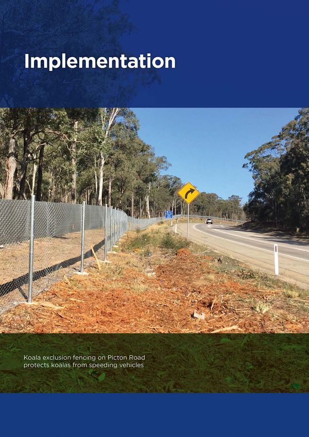
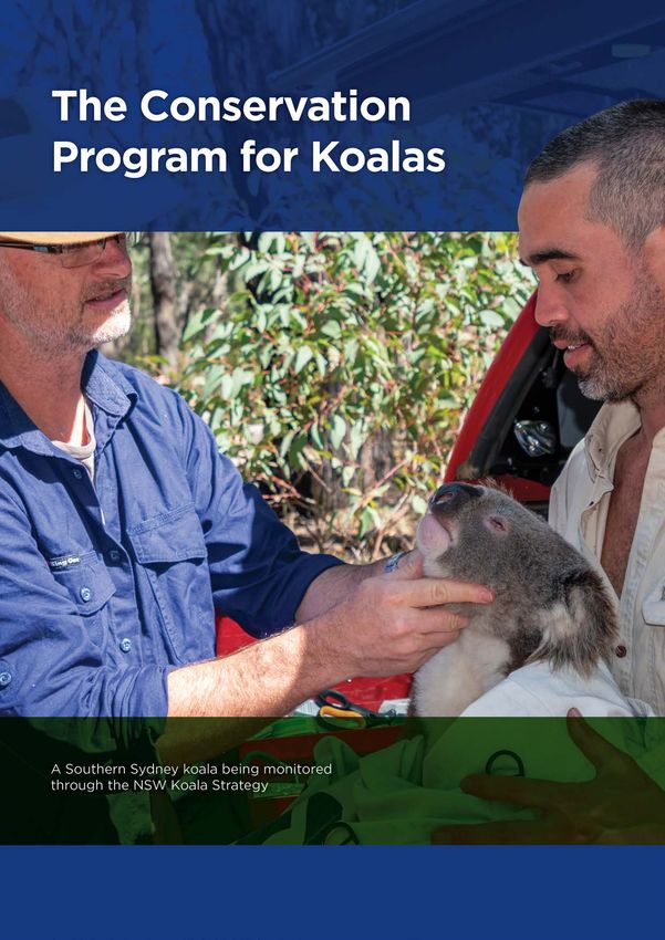
Published by NSW Department of Planning, Industry and Environment
dpie.nsw.gov.au

Title: Sub-Plan B: Koalas
Cover: Koala tagging project in the Southern Highlands
Marie-Claire Demers/DPIE
First published: August 2020

© State of New South Wales through Department of Planning, Industry and Environment 2020. You may copy, distribute,
display, download and otherwise freely deal with this publication for any purpose, provided that you attribute the
Department of Planning, Industry and Environment as the owner. However, you must obtain permission if you wish to
charge others for access to the publication (other than at cost); include the publication in advertising or a product for sale;
modify the publication; or republish the publication on a website. You may freely link to the publication on a departmental
website.

Disclaimer: The information contained in this publication is based on knowledge and understanding at the time of writing
(August 2020) and may not be accurate, current or complete. The State of New South Wales (including the NSW
Department of Planning, Industry and Environment), the author and the publisher take no responsibility, and will accept
no liability, for the accuracy, currency, reliability or correctness of any information included in the document (including
material provided by third parties). Readers should make their own inquiries and rely on their own advice when making
decisions related to material contained in this publication.
Sub-Plan B: Koalas

NSW Department of Planning, Industry and Environment | CM9 Record Number | i
Sub-Plan B: Koalas

Executive summary ........................................................................................................................ 3
Introduction ..................................................................................................................................... 6
   Purpose of Sub-Plan B: Koalas ..................................................................................................... 7
   Conservation program for koalas .................................................................................................. 8
   Community and stakeholder engagement ..................................................................................... 9
   Structure of Sub-Plan B................................................................................................................. 9
The Southern Sydney Koala Population ..................................................................................... 11
   Koalas across Australia and NSW .............................................................................................. 11
   Koalas in the Cumberland subregion .......................................................................................... 11
   Threats to koalas ......................................................................................................................... 14
The Conservation Program for Koalas ....................................................................................... 17
   Avoiding and minimising impacts ................................................................................................ 18
   Mitigating indirect and prescribed impacts .................................................................................. 19
   Conserving koala habitat ............................................................................................................. 24
   Managing landscape threats ....................................................................................................... 32
   Building knowledge and capacity ................................................................................................ 33
Implementation ............................................................................................................................. 37
   Implementation and assurance framework ................................................................................. 37
   Governance ................................................................................................................................. 37
   Delivery partners ......................................................................................................................... 37
   Adaptive management ................................................................................................................ 37
   Monitoring, evaluation and reporting ........................................................................................... 37
Appendix A—Commitments and actions for koalas ................................................................. 39
   Conservation program ................................................................................................................. 39
Appendix B— Chief Scientist Koala Report recommendations and analysis relevant to the
Cumberland Plain Conservation Plan ......................................................................................... 44
References ..................................................................................................................................... 53

                                                             NSW Department of Planning, Industry and Environment | ii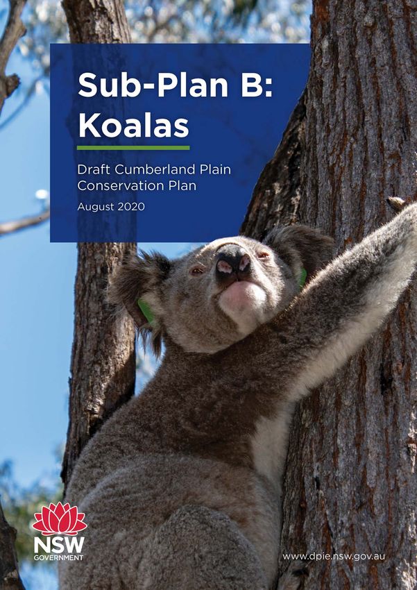
Sub-Plan B: Koalas

Executive summary
The Cumberland Plain Conservation Plan (the Plan) has been developed to meet requirements for
strategic biodiversity certification under the Biodiversity Conservation Act 2016 (NSW) (BC Act)
and strategic assessment under the Environment Protection and Biodiversity Conservation Act
1999 (Cth) (EPBC Act).
Sub-Plan B: Koalas (Sub-Plan B) is one of two sub-plans prepared to support the implementation
of the Plan. The full conservation program is provided in Sub-Plan A: Conservation program and
implementation (Sub-Plan A), which includes 28 commitments and 141 actions to deliver on the
Plan’s vision. Sub-Plan B outlines the conservation program to protect the Southern Sydney koala
population.
Koalas are highly valued by the local community and are one of Australia’s most iconic animals.
They are listed as a threatened species under the Biodiversity Conservation Act 2016 (NSW) (BC
Act) and the Environment Protection and Biodiversity Conservation Act 1999 (Cth) (EPBC Act).
The Southern Sydney koala population, estimated to be between 600 and 1,000 koalas, is a
significant regional population and the largest in the Sydney area. The Southern Sydney koala
population includes koalas in South Western Sydney in the Campbelltown Local Government Area
(LGA) and the eastern section of the Wollondilly LGA and to the Southern Highlands. The koalas in
the Campbelltown LGA are the largest chlamydia-free koala population in NSW.
In August 2020, the NSW Deputy Chief Scientist and Engineer released the Advice on the
protection of the Campbelltown koala population (Chief Scientist Koala Report). Major threats to
koalas include habitat loss and fragmentation (such as from urban development and agriculture),
vehicle strikes, dog attacks (both domestic and wild dogs), drought, bushfires, disease (for
example chlamydia), and climate change.
The conservation program includes specific commitments and actions to protect the Southern
Sydney koala population by addressing the impacts and potential risks to koalas from future
development in the Wilton and Greater Macarthur growth areas. These commitments and actions
were developed on advice from the Chief Scientist Koala Report (2020) and the NSW Koala
Strategy.
The conservation program for koalas will establish the Georges River Koala Reserve east of Appin
Road from Kentlyn through to Appin, protecting up to 1,885 hectares of existing important habitat
and enhance the connectivity of fragmented patches of koala habitat.
The NSW Government has committed $84 million in the first five years to fund priority conservation
actions including planting 100,000 trees to restore koala habitat in the koala reserve and 120
kilometres of koala exclusion fencing in priority locations as well as establish biodiversity
stewardship sites on public and private land.
The conservation program will invest in the NSW Koala Strategy to deliver research, monitoring
and actions. This investment, in partnership with the local community, will support koala health and
welfare in South Western Sydney.

                                         NSW Department of Planning, Industry and Environment | 3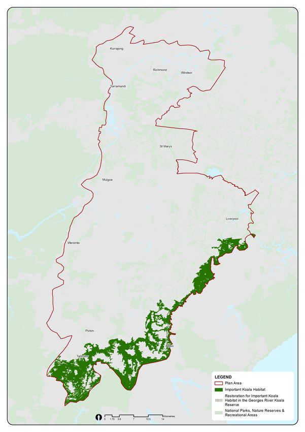
Sub-Plan B: Koalas

NSW Department of Planning, Industry and Environment | 4
Sub-Plan B: Koalas

NSW Department of Planning, Industry and Environment | 5
Sub-Plan B: Koalas

Introduction
The department has undertaken strategic conservation planning to develop the Plan. The Plan
Area covers much of the Cumberland subregion, which is home to a rich variety of plants, animals
and their habitats, including the largest koala population in Sydney.
The Plan been developed to meet requirements for strategic biodiversity certification under the
Biodiversity Conservation Act 2016 (NSW) (BC Act) and strategic assessment under the
Environment Protection and Biodiversity Conservation Act 1999 (Cth) (EPBC Act) in four
nominated areas:
   •   Greater Macarthur Growth Area
   •   Wilton Growth Area
   •   Greater Penrith to Eastern Creek Urban Investigation Area
   •   Western Sydney Aerotropolis.
Major transport infrastructure is planned to respond to the needs of Western Sydney over the next
40 years. The Plan will also facilitate implementation of some of the major infrastructure corridors
identified in Future Transport Strategy 2056, including:
   •   potential future extension of Sydney Metro Greater West, south from Western Sydney
       Aerotropolis to Macarthur (except for those areas in the South West Growth Area)
   •   Western Sydney Freight Line
   •   Outer Sydney Orbital 1
   •   M7/Ropes Crossing Link Road.
It will also support conservation outside those areas through new or additional national parks and
public reserves, investing in biodiversity stewardship sites, and ecological restoration of the
Cumberland subregion’s native vegetation communities.
These actions offset impacts to biodiversity from developing Western Sydney’s nominated areas
and major infrastructure corridors over the next four decades. They will also improve ecological
resilience and function in the Cumberland subregion in perpetuity. This will safeguard Western
Sydney’s natural environment over the long term and in a changing climate.
The Plan provides more information on the scope of development in Western Sydney and its
linkages with other NSW Government plans and strategies. These include the Greater Sydney
Region Plan—A metropolis of three cities (GSC, 2018a), Western City District Plan (GSC, 2018b)
and Future Transport Strategy 2056 (TfNSW, 2018).

                                          NSW Department of Planning, Industry and Environment | 6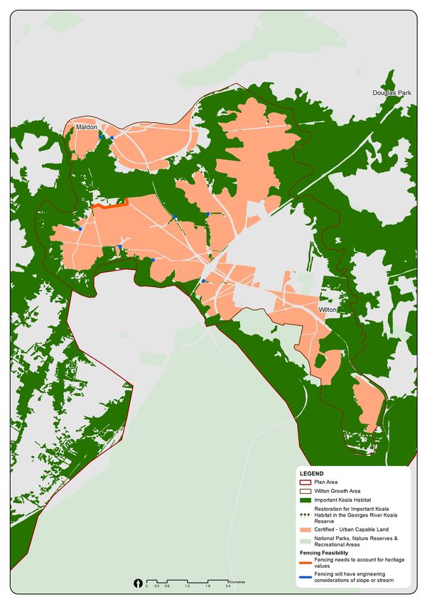
Sub-Plan B: Koalas

Purpose of Sub-Plan B: Koalas
Sub-Plan B is one of two sub-plans that support the implementation of the Draft Cumberland Plain
Conservation Plan (the Plan). The other one is Sub-Plan A: Conservation program and
implementation (Sub-Plan A) (see Figure 1).

Figure 1: Hierarchy of the Draft Cumberland Plain Conservation Plan and sub-plans

Sub-Plan B outlines the conservation program including commitments and actions specifically to
protect and manage koalas and their habitat. These include the establishment of the Georges
River Koala Reserve, the installation of koala-exclusion fencing and actions to support koala health
and welfare.
The Plan is guided by the conservation framework detailed in Sub-Plan A, which details the
conservation program and how it will be implemented to 2056 through its 28 commitments and 141
actions to achieve the Plan’s objective.

Expert advice on the protection of the Campbelltown koala population
In August 2020 the NSW Deputy Chief Scientist and Engineer released an independent, expert
panel report, Advice on the protection of the Campbelltown koala population (Chief Scientist Koala
Report 2020). The Chief Scientist Koala Report advised on the adequacy of the protection of
koalas in the Greater Macarthur Growth Area through the Plan’s conservation program and
consistency with the NSW Koala Strategy. The Chief Scientist Koala Report included several
recommendations relating to the Plan. For further information on these recommendations and an
analysis of how they have been addressed in the Plan, see Appendix B.

                                         NSW Department of Planning, Industry and Environment | 7
Sub-Plan B: Koalas

Conservation program for koalas
The conservation program’s commitments and actions for koalas will ensure persistence and
contribute to the long-term viability of the Southern Sydney koala population.

Outcome for koalas
Outcomes are the intended environmental, economic and social effect or value of delivering on the
Plan’s commitments. The conservation program for koalas comprises 6 commitments and 20
actions that will deliver the outcome for koalas (see Figure 2). The koala-specific commitments and
actions are listed in Appendix A.
The commitments for koalas will be implemented as a series of planned and managed actions over
the life of the Plan. Delivery will be staged according to priority and feasibility over time. The
actions will be reviewed through the Plan’s evaluation program, described in Sub-Plan A, which will
incorporate an adaptive framework for implementing the conservation program for koalas. The
evaluation program will track progress and ensure actions are informed by an ongoing review
process.

Figure 2: Program logic to achieve the Plan's vision

Alignment with existing programs
Existing NSW Government, local council and community programs support koala conservation in
South Western Sydney and across NSW. The Plan’s conservation program for koalas aligns with
the following programs and other local council and community programs that will support delivery
of the commitments and actions.
The NSW Koala Strategy aims to stabilise and then increase koala numbers over the longer-term,
ensuring genetically diverse and viable populations across NSW. It commits $44.7 million to fund a
range of conservation actions for koalas, including providing more koala habitat, supporting local
community action, improving koala health and safety, and building our knowledge to improve koala
conservation.
The NSW Saving our Species Iconic Koala Project (2017) is delivering strategic, on-ground
conservation actions at both a local and state-wide scale, as part of the NSW Koala Strategy.
NSW councils may prepare a Koala Plan of Management (KPoM) under Part 3 of the State
Environmental Planning Policy (Koala Habitat Protection) 2019, as outlined in the Koala Habitat
Protection Guideline (2020). KPoMs may be prepared by councils to take a strategic approach to
the identification and protection of koalas and koala habitat. Once approved, a KPoM may trigger
additional assessments for proposals on sites, depending on the location, including the vegetation
and habitat present. Campbelltown Council had prepared a draft KPoM under the former State

                                          NSW Department of Planning, Industry and Environment | 8
Sub-Plan B: Koalas
Environmental Planning Policy or SEPP (SEPP 44) and this was submitted to the department in
2019 for consideration.
Community and stakeholder engagement
The Plan will be implemented for the people of Western Sydney—both present and future. In
particular, the local community in South Western Sydney are actively engaged in ensuring the
protection of the Southern Sydney koala population.
Since 2017, the department has consulted with the community and stakeholders on the Plan,
including the protection of koalas. These consultations have included local councils, landholders,
environmental groups and members of the community. In 2018, the department ran multiple
meetings with councils and local environment groups to discuss the protection of the Southern
Sydney koala population.
Between July and December 2019, the department coordinated six months of early engagement to
inform the development of the Plan. The exercise was designed to inform stakeholders and seek
preliminary feedback to support development of the draft Plan before releasing it for public
exhibition in 2020. During this period, the department sought community feedback on local
conservation issues, including the protection of the Southern Sydney koala population. The
Campbelltown and Wollondilly communities emphasised protecting the region’s koala population
through new reserves, restoring important habitat and reducing roadkill. A full report on the
community engagement process, including what we heard, is available on the department’s
website.
Structure of Sub-Plan B
Sub-Plan B is structured in three parts:
1. The Southern Sydney koala population provides information on the distribution,
dynamics and potential threats from proposed land use change to the population that
informed the development of the conservation program for koalas.
2. The conservation program for koalas details commitments and actions to address the
impacts and potential risks to the Southern Sydney koala population from planned
development in the Wilton and Greater Macarthur growth areas.
3. The implementation section outlines roles and responsibilities relating to the conservation
program, including governance arrangements for implementing the Plan, and monitoring,
evaluation, reporting and delivery.
NSW Department of Planning, Industry and Environment | 9Sub-Plan B: Koalas NSW Department of Planning, Industry and Environment | 10
Sub-Plan B: Koalas

The Southern Sydney Koala Population
This section summarises the best available information for the Southern Sydney koala population
that informed the development of the conservation program for koalas. This includes the threats
and issues influencing the viability of the population.

Koalas across Australia and NSW
Koalas are one of Australia’s most iconic animals. However, their number and distribution have
significantly declined in recent years. In NSW in 2016, the estimated koala population was around
36,000, representing a 20% decline from slightly more than 45,000 in 1996 (NSW Chief Scientist
and Engineer, 2016). This decline has been more pronounced in locations where urban
development has cleared more habitat and increased threats such as vehicle strikes and dog
attacks.
The widespread bushfires in the summer of 2019–20 also had a significant impact on koala
populations across NSW, Victoria and South Australia. The department is analysing the effect of
these bushfires on koalas and koala habitat across NSW. The findings of this study will inform the
Plan’s adaptive management strategy and assist in delivering a coordinated and targeted response
to support koala recovery efforts.

Koalas in the Cumberland subregion
Koalas once inhabited forests and woodlands on the fertile shale soils across the Cumberland
subregion. Aboriginal history of the subregion speaks about koalas in Dreamtime stories and as a
source of food (Lunney et al, 2015). Following the arrival of European settlers, who cleared land for
agriculture and hunted for the fur trade, the koala population and distribution dramatically declined
in the Cumberland subregion.
The Cumberland Plain has two known populations of koalas: in Southern Sydney, and in the Blue
Mountains, extending from west of the Cumberland subregion to Kurrajong in the north and Bargo
in the south. The Cumberland Plain Assessment Report (the Assessment Report) undertook koala
habitat mapping across all nominated areas. This included mapping of important habitat as
required by the Biodiversity Assessment Method, which built on the work of the department in
mapping habitat around the Greater Macarthur Growth Area and Wilton Growth Area. Koalas were
excluded from further consideration in the assessment in Greater Penrith to Eastern Creek
Investigation Area and the Western Sydney Aerotropolis on the basis that no important habitat was
mapped in these areas. Therefore, koalas in and around the Greater Macarthur Growth Area and
the Wilton Growth Area are the focus of Sub-Plan B and are referred to collectively as the
Southern Sydney koala population.

Southern Sydney koala population
The Southern Sydney koala population is a regional population located near and within the Wilton
and Greater Macarthur growth areas (Office of Environment and Heritage, 2018) (see Figure 3).
The department (formerly the Office of Environment and Heritage or OEH) mapped the extent of
the population in 2018, including koalas from the Campbelltown and Wollondilly local government
areas. The population occurs:
   •   east of Campbelltown and Wollondilly local government areas to the NSW east coast
   •   south from Holsworthy, where it connects with koalas in the Southern Highlands
   •   an unknown distance west towards the Blue Mountains.

                                        NSW Department of Planning, Industry and Environment | 11
Sub-Plan B: Koalas
The habitat has a low carrying capacity, so each koala may require more habitat to meet their life
cycle requirements than in other areas across Australia with a higher capacity (Close et al, 2017).
It is estimated to be between 600 and 1,000 koalas. Because mobile young males aged between
one and three can currently move through the landscape to new habitat, the population is the only
one out of 13 regional populations in NSW that is showing signs of recovery.
The koalas in the Campbelltown local government area make up the largest chlamydia-free
population of koalas in NSW.
Koala movement corridors and habitat in South Western Sydney
Connectivity between important patches of koala habitat is critical to the continued presence of
koalas in South Western Sydney. Koala movement corridors facilitate dispersal of the population,
which supports breeding and protects against localised extinctions. Koalas need large, connected
areas of important habitat for feeding and breeding.
Table 1 categorises primary and secondary corridors that, combined, establish important habitat
for koala movement. Figure 3 identifies the current extent of important koala habitat in the
Cumberland subregion. Most of this is found on the shale and shale-influenced soils in South
Western Sydney.
Table 1: Definitions of koala movement corridors and habitat
Term Definition
Primary Connected area of koala habitat that is contiguous (gaps between trees less
corridors than 100 metres) and greater than 380 hectares in width.
Secondary Movement corridors that are less than 50 metres wide or not connected at both
corridors ends to other koala habitat.
Important Within the Plan, important koala habitat consists of both primary and
habitat secondary corridors. It is the area that is critical to the long-term viability of
koalas (primary corridors) as well as the areas (if enhanced) that would support
the population (secondary corridors).
NSW Department of Planning, Industry and Environment | 12Sub-Plan B: Koalas
Figure 3: Important koala habitat in South Western Sydney
NSW Department of Planning, Industry and Environment | 13Sub-Plan B: Koalas
Threats to koalas
Koala populations in NSW are declining despite a range of initiatives to protect them (NSW Chief
Scientist and Engineer, 2016). Threats to koalas that are associated with human activity include:
• habitat loss and fragmentation
• vehicle strike
• proximity of urban development including domestic dog attacks, light and noise
• bushfires
• disease (particularly chlamydia)
• climate change (which increases drought and heatwaves, and alters habitat quality) (NSW
Chief Scientist and Engineer, 2016)
Koalas in South Western Sydney will be exposed to some of these threats as land use changes
and development proceeds within the nominated areas.
Habitat loss and fragmentation
Koalas need large, connected areas of important habitat for their food and breeding. Impacts to
habitat include loss in the size of the habitat, but also the fragmentation of the habitat. This creates
remnant patches that can isolate koalas in small woodlots. Direct impacts to primary corridors are
the most significant, as these corridors provide for ecological function of the population. Impacts to
secondary corridors are also of concern, as they have the potential to play a supporting role within
the landscape. However, secondary corridors are considered less important because they:
• have narrow points (less than 50 metres wide), which can create bottlenecks for movement
and expose koalas to greater edge effects, or
• are not connected at both ends, which means they lack important landscape function at the
population level.
Other habitat may be locally significant, but at a regional level, is poorly connected and provides
only scattered trees across the landscape. The habitat may provide small stepping-stone patches,
but moving between the isolated trees can leave koalas exposed to dogs and other threats. Due to
its size and edge effects, the koalas are also more exposed and vulnerable to fluctuations in
available food and water.
Without appropriate management of the landscape, increasing human activity could lead to
adverse environmental impacts to koala habitat.
Vehicle strike
Vehicle strike refers to a vehicle colliding with a koala as it attempts to cross a road. Usually, the
koala will be killed or injured. Without appropriate mitigation measures, the increasing traffic
density associated with urban development is likely to increase the risk of vehicle strikes. Several
major roads in or adjacent to koala habitat in South Western Sydney have crossings requiring
management to prevent vehicle strike.
Koalas are highly mobile and typically move at night. As rural roads are not generally well lit, it can
be difficult for road users to see them. Over the past decade, there has been a significant increase
in koala fatalities from vehicle strikes. It is reasonable to assume that future urban land use
changes, as part of the nominated areas and increasing traffic on major roads, will increase the
threat to koalas from vehicle strikes.
NSW Department of Planning, Industry and Environment | 14Sub-Plan B: Koalas
Proximity of urban development
Urban development in proximity to koala habitat poses several threats to koalas, particularly in the
Wilton and Greater Macarthur growth areas. These threats can affect dispersing koalas, which
travel through urban areas, in addition to locally resident koalas living nearby. Threats include:
• domestic dog attacks
• swimming pools
• light and noise
• habitat degradation due to increased edge effects from land clearing and greater risk of
disturbance (for example, slashing, pollution and illegal dumping).
Without specific mitigation actions, threats to koalas near urban areas will increase as the
population grows.
Bushfire
Bushfire is a threat to koalas through loss of habitat, death or starvation due to food shortages. The
bushfires in the summer of 2019–20 demonstrated the catastrophic impact of fires on local koala
populations and their habitat, with a loss of 25% of suitable koala habitat in eastern NSW (EES,
2020). However, there was no direct impact to the Southern Sydney koala population and their
habitat. Effects of climate change will likely increase the risk of impacts to koalas from fire over
time.
Disease
Chlamydia is a serious disease that can lead to koala infertility and death, though not all infected
koalas are symptomatic. Koalas in the Campbelltown area are considered to be free of chlamydia,
though the bacteria has been recorded elsewhere in the Southern Sydney koala population. Urban
development has the potential to increase the severity of chlamydia symptoms and therefore
increase infertility and mortality rates (McAlpine et al, 2017).
Climate change
Climate change contributes to drought, heatwaves and altered habitat quality and will affect the
Southern Sydney koala population. On average, Western Sydney experiences 10–20 hot days a
year (with maximum temperatures above 35° C). However, by 2039 Western Sydney is predicted
to experience an additional 5–10 hot days a year and an additional 10–20 hot days by 2070 (OEH
2018). Management of heat stress and habitat will be required increasingly for the Southern
Sydney koala population.
NSW Department of Planning, Industry and Environment | 15Sub-Plan B: Koalas NSW Department of Planning, Industry and Environment | 16
Sub-Plan B: Koalas

The Conservation Program for Koalas
This section outlines the conservation program for koalas. The conservation program has been
developed to address impacts and potential risks to koalas in Western Sydney associated with
existing and planned development in the Wilton and Greater Macarthur growth areas. The
conservation program for koalas includes commitments that have been categorised into the
following five categories.

                                      NSW Department of Planning, Industry and Environment | 17
Sub-Plan B: Koalas
Avoiding and minimising impacts
Avoiding and minimising highlights:
Avoid impacts to at least 3,720 hectares of koala habitat in the nominated areas.
This section describes actions to avoid and minimise impacts to at least 3,720 hectares of koala
habitat. This is 26% of the total known koala habitat in the Plan Area. Avoiding and minimising is
an important part of strategic conservation planning and is required under the Biodiversity
Conservation Act 2016 (NSW) (BC Act) and the Environment Protection and Biodiversity
Conservation Act 1999 (Cth). The Plan has prioritised landscape-scale avoidance of the potential
impacts of urban development on koala habitat in the Western Sydney nominated areas.
Avoiding impacts to koala habitat
The certified - urban capable land is where future urban development is likely to occur in each
nominated area. Important koala habitat in the Wilton and Greater Macarthur growth areas was
mapped in 2018 (Office of Environment and Heritage, 2018) and updated for the Plan. Through
application of a set of avoidance criteria, at least 3,720 hectares of the mapped koala habitat has
been avoided from the certified - urban capable land. The avoidance criteria were also applied on
cleared land that had previously supported koala habitat if the land was in an important koala
corridor.
This means that development will be avoided in almost 74% of the important koala habitat,
including 1,190 hectares in the Wilton Growth Area and 1,675 hectares in the Greater Macarthur
Growth Area.
This boundary determination will be implemented through the Greater Macarthur and Wilton Land
Use and Infrastructure Implementation Plans (LUIIPs) and precinct-planning process.
The Assessment Report calculated that 260 hectares of important koala habitat could be impacted
by development in the Wilton and Greater Macarthur growth areas. These predicted impacts will be
offset through the conservation program.
Protecting koala habitat
Avoided areas inside nominated areas, including those avoided for koala habitats, will be protected
through the application of environmental conservation zoning. An environmental zoning can be
applied to private or public land where the primary focus for that land is the conservation and/or
management of environmental values and sets out land uses that are permissible and prohibited.
Environmental conservation zoning will not be applied on land owned by Local Aboriginal Land
Councils (LALCs) or under claim by LALCs. Aboriginal-owned land and land under claim
represents 90 hectares of the total 4,795 hectares of avoided land.
The Explanation of Intended Effect for the proposed State Environmental Planning Policy
(SEPP) Strategic Conservation Planning provides further detail about how proposed environmental
zoning will be applied within nominated areas.
NSW Department of Planning, Industry and Environment | 18Sub-Plan B: Koalas
Mitigating indirect and prescribed impacts
This section describes how the conservation program will manage threats to koalas by constructing
exclusion fencing and applying controls from the Koala Habitat Protection Guideline and including
design requirements in the relevant development control plans.
Mitigating indirect and prescribed impacts highlights:
Mitigate indirect and prescribed impacts from urban, transport and agricultural development on
koalas, using best-practice standards, by:
• installing exclusion fencing between important koala habitat and the certified - urban-capable
land to protect koalas and along Appin Road
• implementing additional requirements for the few locations where exclusion fencing is not
feasible, including where the slope of the land is greater than 30 degrees; across a
watercourse and adjacent to heritage-listed assets
Protecting koalas from the urban related threats
Indirect and prescribed impacts to koalas are often associated with human activities associated
with urbanisation. Urban threats for koalas include habitat loss and fragmentation, vehicle strikes,
dog attacks (both domestic and wild dogs) and drowning in swimming pools. The transition from
rural to urban land uses in the Wilton and Greater Macarthur growth areas will require careful
strategic planning.
Koala-exclusion fencing
In the first three years of implementation, the Plan will fund the installation of 120 km of koala-
exclusion fencing to protect koalas from increasing threats of vehicle strikes, dog attacks and
drowning in swimming pools.
Koala-exclusion fencing will be installed between important koala habitat and the certified - urban
capable land to protect koalas near urban areas in the first three years of implementation
(Commitment 7, Action 1). Exclusion fencing will separate koalas from future urbanised areas in
the Wilton and Greater Macarthur growth areas. The exact location and design (see Case Study 2)
of exclusion fencing in these nominated areas is subject to ground truthing during the Plan’s
implementation but will be at least three metres from koala habitat trees (Commitment 7, Action 2).
In some circumstances, exclusion fencing may not be feasible due to:
• land topography or road access constraints that make it difficult to install and maintain
fences
• waterways or creeks
• being a heritage-listed area.
See Figure 7 and Figure 8 for important koala habitat and locations where exclusion fencing may
not be suitable.
NSW Department of Planning, Industry and Environment | 19Sub-Plan B: Koalas
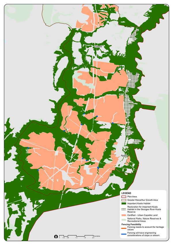
Figure 4: Important koala habitat and locations where exclusion fencing may not be suitable in
Greater Macarthur Growth Area
NSW Department of Planning, Industry and Environment | 20Sub-Plan B: Koalas
Figure 5: Important koala habitat and locations where exclusion fencing may not be suitable in
Wilton Growth Area
NSW Department of Planning, Industry and Environment | 21Sub-Plan B: Koalas
In these areas, bespoke fencing will be considered. However, in cases where exclusion fencing is
not possible, controls will be developed according to the Koala Habitat Protection Guideline made
under the Koala Habitat Protection SEPP 2019. These controls will apply to land 60 metres from
important koala habitat and design requirements included in the relevant development control
plans (Commitment 7, Action 3).
Where fencing is not possible, the asset protection zone will also act as a buffer to the koala
habitat. An APZ is a buffer zone between a bushfire hazard and buildings. Further detail on the
APZ is provided in Sub-Plan A.
Where access is required for community safety or fauna escape during bushfires, or for
maintenance, gates will be designed as part of the fencing implementation program. Gate
management will be undertaken by local councils and the Rural Fire Service.
Where fencing must cross existing or planned linear infrastructure such as gas and electricity
transmission, appropriate access treatments such as gates will be considered to ensure the
integrity of the koala-exclusion fencing.
In the first three years of implementation of the Plan, koala-exclusion fencing will also be installed
along Appin Road to mitigate vehicle strike for koalas (Commitment 7, Action 3). Vehicle strikes on
Appin Road is a well-known threat to the koalas in South Western Sydney. This will be
implemented in partnership with TfNSW (see Box 2).
Fencing will be installed in accordance with the recommendation from the Chief Scientist Koala
Report. It will be installed within the first 1–3 years of the Plan’s implementation program.
Case study 2. Koala-exclusion fencing design
Transport for NSW has installed a ‘floppy-top’ fence along Wilton Road in South Western Sydney that is
topped with an angled and unsecured section that bends under a koala’s weight, preventing them from
climbing over.
‘Slippery-top’ fencing has superseded the floppy-top design. This type of fence was recently installed over
a 4.5-kilometre koala roadkill hotspot, along Picton Road in South Western Sydney. A 60-centimetre strip
of steel or heavy plastic sheeting tops the fence on the side of the koala habitat. The sheeting prevents
koalas getting a grip to climb over the top section.
NSW Department of Planning, Industry and Environment | 22Sub-Plan B: Koalas
Box 2. Upgrade of Appin Road and koala crossing at Kings Fall Bridge
Transport for NSW is primarily responsible for funding and implementing mitigation measures to reduce
vehicle strikes involving koalas and other animals along major roads.
Two Reviews of Environmental Factors (REFs) have been released for the upgrade and safety
improvements of Appin Road between Rosemeadow and Mount Gilead. The upgrade will unlock new
housing at Mount Gilead and improve safety and access for local residents and through traffic. The upgrade
will be funded and delivered by Lendlease under a voluntary planning agreement with the NSW Government
as part of the Figtree Hill residential development. The NSW Government will also provide part-funding for
the road works under the Housing Acceleration Fund program.
As part of the Appin Road upgrade, fauna-exclusion fencing will be installed to reduce the current levels of
roadkill on Appin Road. This fencing will protect koalas from vehicle strike and direct koala movement to the
south and south-west and within primary habitat corridors mapped by the department’s Environment, Energy
and Science group.
The Appin Road upgrade includes fauna exclusion fencing and/or barriers at suitable locations on either side
of Appin Road. Whilst the fauna exclusion fencing is predominantly focussed on the eastern side of Appin
Road opposite Lendlease’s Figtree Hill development, there will koala-exclusion fencing along the western
side of Appin Road at Noorumba Reserve.
Transport for NSW is now preparing a detailed design for Appin Road safety improvements between Mount
Gilead and Appin. The $50-million package is funded by the Commonwealth Government to improve safety
on Appin Road and support affordable housing in the Greater Macarthur Growth Area.
The Appin Road safety improve project would involve shoulder widening on both sides of Appin Road near
Beulah Reserve and to the north of Beulah Reserve. The offset between the shoulder and safety barrier on
both sides of Appin Road would be reduced to about 2.5 metres to avoid property acquisition from the
property directly to the east, which contains an endangered ecological community and from Beulah Reserve
as a recognised biobank site.
The safety works will also include installing koala-exclusion fencing along Appin Road at areas of potential or
known habitat. As part of the koala-exclusion fencing strategy under current consideration, grids would be
installed at driveway access points to maintain access but to prevent movements on the road corridor. The
fencing is scheduled to be installed in 2022.
Transport for NSW proposes to augment the existing Kings Falls Bridge at the Georges River by constructing
a concrete bench adjacent to the bridge abutments that would allow dry passage for koala (and other fauna)
under the bridge. This would ensure north–south connectivity for koala movement from the Georges River
Koala Reserve to the southern koala habitat. The department will work with Transport for NSW to ensure that
koala-exclusion fencing is installed on both sides of Appin Road before installation of the bridge passage to
channel koalas under the bridge and prevent access to Appin Road (Commitment 12, Action 6). This action
will be delivered in the first five years of the Plan’s implementation.
Transport for NSW may fund additional exclusion fencing at other hotspot areas as part of major road
upgrades throughout the life of the Plan.
The Plan will fund installation of koala-exclusion fencing on both sides of Appin Road between Mount Gilead
and Appin Village in all areas not fenced by Transport for NSW through their planned upgrade. This action
will be delivered in the first five years of the Plan’s Implementation (Commitment 7, Action 4).
NSW Department of Planning, Industry and Environment | 23Sub-Plan B: Koalas
Conserving koala habitat
Conserving koala habitat highlights:
Establish the Georges Rivers Koala Reserve to secure the north–south koala movement corridor
along the Georges River between Appin and Kentlyn.
Restore up to 200 hectares of important koala habitat in Georges River Koala Reserve and other
priority areas.
Secure priority areas of koala habitat in the Cumberland subregion in perpetuity.
Facilitate koala movement for at least one east–west koala corridor by constructing an animal
crossing at Appin Road.
This section describes how the conservation program will protect priority areas of koala habitat to
support the Southern Sydney koala population while offsetting habitat loss.
The Chief Scientist Koala Report recommends the protection of koala corridor habitat. The Plan’s
conservation program will establish new conservation lands to protect koala habitat that will be
secured in perpetuity. Conservation lands include additions to existing public reserves, new public
reserves and biodiversity stewardship sites. Ecological restoration of koala habitat will also be
prioritised in conservation lands, to expand koala habitat and facilitate koala movement.
Public reserves and biodiversity stewardship sites will protect existing koala habitat and provide
environmental buffers against adverse impacts and fauna corridors to improve landscape
connectivity for koalas. Ecological restoration in reserves and biodiversity stewardship sites will
play an important role in enhancing connectivity between remnant habitat patches and improving
the condition of existing koala habitats.
Establishment of the Georges River Koala Reserve
The conservation program will establish the Georges River Koala Reserve, the most important
north–south koala movement corridor along the Georges River between Appin and Kentlyn (see
Figure 4) (Commitment 10). This north–south corridor has high-fertility shale and shale-influenced
transition soil that supports preferred koala feed trees. The reserve will facilitate movement of
koalas between Campbelltown and the Southern Highlands and promote the genetic diversity of
the species.
The establishment of the Georges River reserve was recognised in the Chief Scientist Koala
Report as essential to the persistence of the Southern Sydney koala population. The reserve will
protect and manage up to 1,885 hectares (including ecological restoration), which is three times
the required offset target for important koala habitat for the Plan. The first 800 hectares of publicly
owned land was announced in November 2018 to be set aside as part of the reserve. There is also
an opportunity to restore up to 200 hectares of important koala habitat within the reserve. The
reserve will also give local communities accessible public space for recreation, such as walking,
education opportunities and may provide opportunities for koala-based tourism.
The Chief Scientist Koala Report recommends a minimum corridor width of 390 metres, plus an
additional 30m buffer for a safe koala corridor. Based on desktop mapping, it is estimated that this
NSW Department of Planning, Industry and Environment | 24Sub-Plan B: Koalas
width is achieved in 99% of the primary north-south koala movement corridors along the Nepean
and Georges rivers. The north–south koala movement corridor (the proposed Georges River Koala
Reserve) is also greater than the minimum recommended widths. Restoration will be targeted in
some locations to widen the corridor, and this analysis will be refined when the koala exclusion
fencing is designed and installed.
Implementation of the Georges River Koala Reserve
The NSW Government will prioritise the establishment of the Georges River Koala Reserve in the
first 10 years of implementing the Plan.
The Georges River Koala Reserve will be established in two stages, comprising in total up to 1,885
hectares of land. Stage 1a will include approximately 700 hectares (Commitment 10, Action 1) and
1b approximately 430 hectares of land (Commitment 10, Action 2). Stage 2 will comprise up to 755
hectares of additional land that will be added to the reserve by 2040 (see Figure 4) (Commitment
10, Action 4).
The Office of Strategic Lands (OSL) owns around 760 hectares of land proposed for the reserve
and is currently establishing biodiversity stewardship agreements over some of its holdings. OSL
has been acquiring land in this corridor since the 1980s under the Regional Open Space program.
Any Biodiversity Stewardship Agreements established before implementation of the Plan will
generate credits that will be purchased under the conservation program.
OSL will manage the land acquisition program for the reserve. It will aim to acquire land for Stage 1
of the Georges River Koala Reserve in the first 5 years and for Stage 2 by year 10 of the Plan’s
operation, subject to and in close consultation with affected landowners. Once acquired, OSL will
establish biodiversity stewardship agreements to generate biodiversity credits that will be used to
cover costs associated with future management of the reserve.
When the land acquisition program is complete and stewardship agreements are established,
ownership and management of the reserve will be transferred to the NSW National Parks and
Wildlife Service (NPWS) in accordance with the National Parks and Wildlife Act 1974 (NSW)
(Commitment 10, Action 3).
Restoration in the Georges River Koala Reserve
Koala habitat in South Western Sydney is highly fragmented between remnant patches of
important koala habitat. Ecological restoration, which helps degraded and damaged ecosystems
return to a more natural state, will help to improve connectivity and expand the total area of koala
habitat in South Western Sydney.
In the first five years of delivering the conservation program, the NSW Government will plant
100,000 trees to restore important koala habitat in Georges River Koala Reserve, along Ousedale
Creek, around Appin and other priority locations in the strategic conservation area.
The conservation program will restore around 200 hectares of land in the Georges River Koala
Reserve over the life of the Plan (Commitment 10, Action 5). The higher fertility shale and shale-
influenced soils provide an opportunity to restore plant community types that are preferred by the
Southern Sydney koala population, including Grey Box, Grey Gum, and Narrow-leaved Ironbark
trees.
NSW Department of Planning, Industry and Environment | 25Sub-Plan B: Koalas
Figure 6: Proposed staging of the Georges River Koala Reserve
NSW Department of Planning, Industry and Environment | 26Sub-Plan B: Koalas
Secure additional priority areas of koala habitat
Only 9% of the 14,430 hectares of important Southern Sydney koala habitat is currently protected
and managed through public reserves or private land conservation.
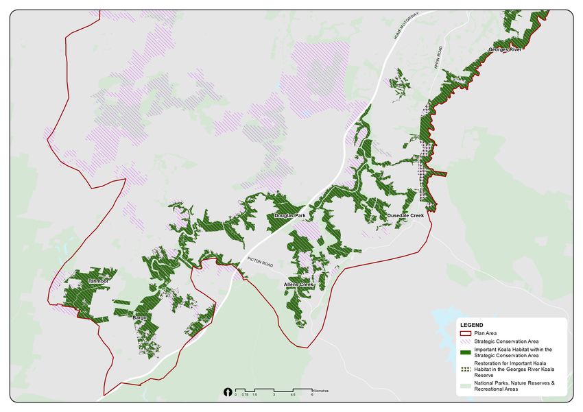
In addition to the Georges River Koala Reserve, around 7,345 hectares of important koala
movement corridors and habitat have been identified within the strategic conservation area that are
potential candidates for conservation lands (Figure 5). Some locations in the strategic conservation
area include Allens Creek, Douglas Park, Tahmoor, Bargo and the Nepean River. Protecting and
restoring these areas in the strategic conservation area would help support the viability of the
Southern Sydney koala population.
All east–west koala corridors within the Plan Area will be protected (for vegetation) using
environmental conservation zoning. Where not feasible due to width, the corridor will be fenced to
exclude koalas but can be considered for future restoration to support koala movement, noting at
least one will be secured for koala movement including safe crossing of Appin Road through the
Plan (Commitment 12, Action 3).
Box 1. Strategic conservation area
The strategic conservation area is identified as having the greatest potential to deliver long-term
conservation outcomes for biodiversity in the Plan Area. They include large patches of native vegetation with
good connectivity to other such patches, or areas with the potential to enhance connectivity that directly
offset impacts to koalas and other threatened species and ecological communities. The strategic
conservation area will be monitored over the life of the Plan and regularly refined as constraints and
opportunities change.
The department has identified the Plan’s strategic conservation area that contains around 28,300 hectares of
land in Western Sydney. Excluding the Georges River Koala Reserve, 26% of these areas are important
koala habitat (see Figure 5).
At their request, land owned by Deerubbin LALC has been excluded from the strategic conservation area.
Land owned or under claim by other LALCs is included in the strategic conservation area, but the planning
controls proposed for this conservation area will not be applied to LALC owned or claimed land.
NSW Department of Planning, Industry and Environment | 27Sub-Plan B: Koalas
Figure 7: Important koala habitat within the strategic conservation area
Implementation of reserves and biodiversity stewardship sites
The establishment of additional conservation lands to protect koala habitat will include both
reserves and biodiversity stewardship sites (Commitment 12, Action 2). The Office of
Strategic Lands will manage the land acquisition program, which will include establishing
Biodiversity Stewardship Agreements over land that is suitable for future reserves. This
approach will ensure adequate funding is available for long-term management by NPWS or
councils.
Land acquisition will be phased staged over the life of the Plan and the complexity of the
acquisition process will depend on the number of lots and landholders to be negotiated with
for each reserve proposal.
Biodiversity stewardship sites provide permanent protection for threatened species and
ecological communities, including koalas, while enabling private or public landholders to
continue to use their land outside the site as normal.
The NSW Government does not need to acquire land to establish a biodiversity stewardship
site. Instead, a landholder enters into a Biodiversity Stewardship Agreement with the NSW
Government, and can generate biodiversity credits and earn income from trading these
credits under the Plan.
The landholder receives support from the Biodiversity Conservation Trust, including an
annual payment from funds held and invested on their behalf, to undertake the required
management actions. Landholders don’t need to set aside all their land for a Biodiversity
Stewardship Agreement.
NSW Department of Planning, Industry and Environment | 28Sub-Plan B: Koalas
More details about the reserve and biodiversity stewardship programs and their implementation are
provided in Sub-Plan A.
Case study 1 provides information on a Biodiversity Stewardship Site established in Douglas Park,
an important area in Western Sydney for koalas, to protect and manage koala habitat and other
important biodiversity values.
Case study 1. St Mary’s Towers biodiversity stewardship site at Douglas Park
St Mary’s Towers biobank site at Douglas Park in the Wollondilly LGA was established in 2010 under an
agreement between the landowner and the NSW Minister for the Environment. A biobank is a historic type
of agreement, similar to a Biodiversity Stewardship Agreement.
This site contains Cumberland Plain Woodland and Shale Sandstone Transition Forest that provides habitat
for koalas and a range of other threatened species. Allens Creek also flows adjacent to the site, making it
part of an important koala corridor between the Nepean and Cataract rivers that is also protected.
St Mary’s Towers is divided into 10 management zones that are informed by vegetation type, condition and
management objective. Actions required under the biobank agreement include managing grazing, weeds,
use of fire, stressors created by human activity, erosion and feral animals, and replanting of native plants.
While the agreement was being established, the former Office of Environment and Heritage provided advice
and support to the landowner, which included identifying and costing proposed management actions.
Management of the land has generated credits worth more than $1.7 million. The landholder received
$1 million and more than $500,000 was deposited into a trust, which is used to deliver management actions.
The credits from this biobank site were purchased under the Growth Centres Biodiversity Offset Program.
Source: OEH 2017, Conservation achievements: St Mary’s Towers biobank site
Secure one east–west Koala movement corridor between the Georges and
Nepean rivers
East–west connectivity between the Georges and Nepean rivers is important for the resilience of
the Southern Sydney koala population. However, scientific advice from the department and the
research community suggest that the existing six east–west corridors in the Greater Macarthur
Growth Area are too fragmented and not wide enough to support koalas over the long term (Figure
6). The Chief Scientist Koala Report recommends a width of 390–420 metres for a safe koala
corridor.
The department, under the Plan will secure at least one east–west koala movement corridor
(Commitment 12, Action 3,4,5). Using ecological restoration to ensure enough width and a fauna
crossing for safe koala movement across Appin Road (Commitment 12, Action 4,5). Corridor E
(Figure 6) at Ousedale Creek to Appin North is recommended by the Chief Scientist Koala Report
as the most suitable for koala movement because of the condition and width of the existing
vegetation. Box 4 provides more information.
The securing and enhancing of at least one east–west corridor, likely the Ousedale corridor, will
start in the first five years of the Plan’s implementation, with a feasibility study currently underway
for implementation.
Native vegetation within all east–west koala movement corridors will be protected through
environmental zoning following approval of the Plan, consistent with the Chief Scientist Koala
Report (Commitment 12, Action 3).
NSW Department of Planning, Industry and Environment | 29Sub-Plan B: Koalas
Figure 8: Potential east–west corridors connecting Nepean River to Georges River A) Menangle
Creek to Noorumba B) Woodhouse Creek to Beulah C) Nepean Creek to Beulah D) Mallaty Creek to
Georges River E) Ousedale Creek to Appin North F) Elladale Creek and Simpson Creek to the colliery
NSW Department of Planning, Industry and Environment | 30Sub-Plan B: Koalas
Ecological restoration of koala habitat
Most of the Southern Sydney koala population prefers feed trees such as grey gum and blue-
leaved stringybark that are found on nutrient-rich soils derived from Wianamatta shale. Due to
historical clearing for agriculture, these vegetation types were largely removed from the landscape
and only fragmented patches of koala habitat remain.
To enhance the connectivity between patches of koala habitat, and augment and strengthen
existing primary and secondary koala corridors, native vegetation on Wianamatta shale soils
should be restored. In addition to the 200 hectares of ecological restoration proposed in the
Georges River Koala Reserve, around 1,920 hectares of cleared or degraded land has been
identified across the strategic conservation area for potential restoration of koala habitat.
In line with the recommendation of the Chief Scientist Koala Report, the Plan’s Restoration
Implementation Strategy will clarify approaches to ensure the long-term sustainability of restoration
considers genetic diversity in what is planted (Commitment 13).
Sub-Plan A provides more detailed information about the ecological restoration program and its
implementation.
NSW Department of Planning, Industry and Environment | 31You can also read