Eastbank PLANNING + DESIGN PRINCIPLES PUBLIC ENGAGEMENT SUMMARY - JULY 2021 METRO NASHVILLE PLANNING DEPARTMENT
←
→
Page content transcription
If your browser does not render page correctly, please read the page content below
eastbank
PLANNING + DESIGN PRINCIPLES
PUBLIC ENGAGEMENT SUMMARY

     JULY 2021   METRO NASHVILLE PLANNING DEPARTMENT
                                 eastbankstudy.nashville.gov
IMAGINE EAST BANK
PLANNING + DESIGN
PRINCIPLES PUBLIC
ENGAGEMENT SUMMARY

Workshops
  Workshop 1 - July 14 Lunch (52 attendees)
  Workshop 2 - July 14 Evening (40 attendees)
  Workshop 3 - July 15 Evening (49 attendees)

Online Survey
  Open from July 14 - July 23 (605 responses)
CONTENTS
  Introduction
  Page 4
  Station 1 - Programming of Public Spaces
  Page 6
  Station 2 - Authenticity
  Page 9
  Station 3 - Circulation and Mobility
  Page 12
  Station 4 - Resilient River
  Page 17
  Station 5 - Planning and Design Principles
  Page 21
  Station 6 - Land Use Mix
  Page 25
  Online Survey Results
  Page 30
  Appendix A - Workshop Comments
  Page 38

PLANNING + DESIGN PRINCIPLES PUBLIC ENGAGEMENT SUMMARY   IMAGINE EAST BANK   3
INTRODUCTION
    The Metro Nashville Planning Department and design
    firm, Perkins Eastman, are undertaking a multi-month
    study focused on the future land use, urban design,
    mobility, open space, and environmental resiliency
    of the East Bank. The Study will guide cohesive and
    coordinated redevelopment of the East Bank, through
    updates to the street plan, and changes to Nashville’s
    long-range general plan, NashvilleNext.

    The three Planning and Design Principles Workshops
    in July were one of a number of steps in the broad
    public process of the study. Workshop facilitators
    hosted about 50 people at each workshop. The
    workshops were held in the Bridge Building, adjacent
    to the John Seigenthaler Bridge, in the study area.

    Principals from Perkins Eastman and Planning Staff
    briefly presented progress updates, as well as the
    schedule for the study. At these workshops attendees
    were asked to give their opinions on a wide range
    of topics at six stations focused on public spaces,
    authenticity, circulation/mobility, the river, planning
    and design principles, and the land use mix.

    In addition, over 600 people responded to an online
    survey posted on the East Bank study website that
    mirrored many of the questions raised during the in-
    person workshops.

    The results from both of these public engagement
    opportunities are presented in this report.

    Near the end of August 2021, Planning Staff will
    host additional workshops dealing primarily with
    transportation and public space, anticipating an
    update to the Major and Collector Street Plan.

4    IMAGINE EAST BANK                                        PLANNING + DESIGN PRINCIPLES PUBLIC ENGAGEMENT SUMMARY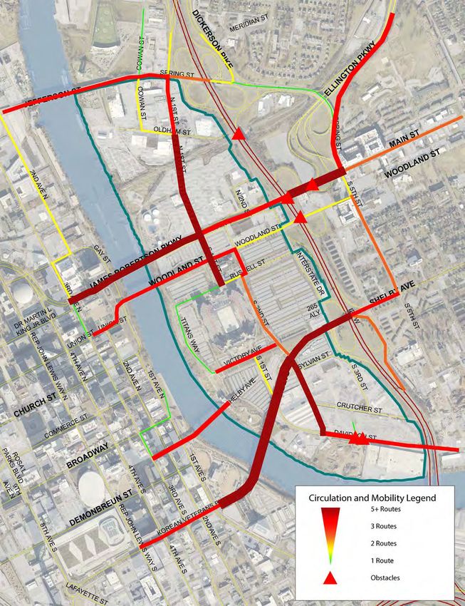
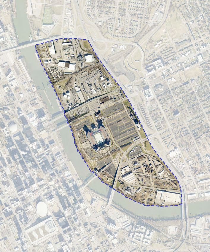
The Study Area

  The East Bank study area is roughly 338 acres,
  bounded by I-24 to the east and south, the
  Cumberland River to the west, and Jefferson Street
  to the north. Images showing the existing character
  within the study area are to the right. The study focuses
  primarily on the area highlighted on the map below,
  however, the area of influence, extends into East
  Nashville and into Downtown.

  Currently, the study area includes a number of
  industrial uses. In addition, Nissan Stadium and its
  accompanying infrastructure resides in the center
  of the study area. It also includes key pieces of the
  regional transportation infrastructure, including I-24,
  the Cumberland River, and key bridges across the
  river.
                                        Jeffers
                                               on St.

                                                        Old                                                    Sp
                                                                ham                                              rin
                                                                       St.                                          gS
                                                                                                                       t.

                                                  James Robertson Pkwy.
                                                                                                                    Main St.

                                                      Woodland Ave.
        1st Ave. N.

                                               Titans
                                                                      S. 2nd St.

                                              Stadium

                                                                                              Shelby Ave.
                                                   S. 1st St.

   Broadway

                            ridge
                      Ped. B
                                              d.
                                          Blv
                                          s
                                       an r
                                       ete

                                                                                           Cru
                                     nV

                                                                                               tch
                                                                                                    er
                                  rea

                                                                                                         St.
                                Ko

                                                                                   Da
                                                                                     vid
                                                                                        son
                                                                                              St.
                      He
                      rm
                       ita
                          ge
                           Av
                              e.

PLANNING + DESIGN PRINCIPLES PUBLIC ENGAGEMENT SUMMARY                                                                         IMAGINE EAST BANK   5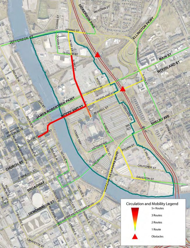
STATION 1 - PROGRAMMING OF PUBLIC SPACES
    Station Instructions
    Station facilitators asked workshop attendees to
    distribute $38.00 of “Metro Money” into boxes,
    each representing a different kind of public space.
    Workshop attendees were given the following bills:

                     1                          5
        3x                          1x
                    10                          20
        1x                          1x
    Summary and Results
    Nature trails and a marina were the top public space
    options as voted on by workshop attendees. These top
    earners were funded primarily by $20 bills, and so it
    can be said that these spaces are strongly desired. A
    marina, and event space (3rd place), are notable as
    they are two kinds of public space that can be costly
    to build, yet highly profitable.

    Conversely, low overall earners, like dog park and
    playground facilities, received a quarter of their
    funds from $1 bills. This tells us that these options are
    desired by many people, but not as strongly as some
    of the other options. Compared to a marina and event
    space, these things are relatively cheap to build and
    take up a limited amount of space.                             Note: The following pages provide a more detailed look
                                                                   at how many of each bill type were placed in each box.

    Totals
                  dog park $124

           riverfront drive $192

    public swimming area $261

      playground facilities $277

recreational fields/courts $399

               event space $510

                   marina $828

               nature trails $926

                                $0       $100    $200       $300 $400     $500 $600         $700    $800      $900 $1000

6    IMAGINE EAST BANK                                          PLANNING + DESIGN PRINCIPLES PUBLIC ENGAGEMENT SUMMARY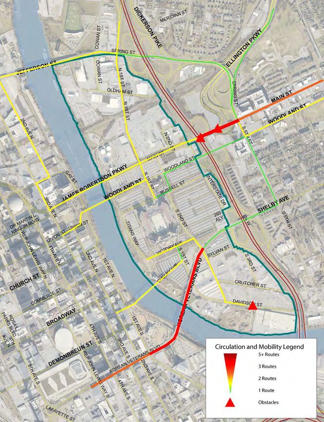
Breakdown of Totals
                    eastbank

             nature trails                    nature trails
     price      land area    public revenue
                                               20   20   20   10   5    5   1   1   1   1   1
                                                                                                     $926
                               generation      20   20   20   10   5    5   1   1   1   1   1
                                                                                                      dollars
                                               20   20   20   10   10   5   1   1   1   1   1        allocated
                                               20   20   20   10   10   5   1   1   1   1   1

                                               20   20   20   10   10   5   1   1   1   1   1

                                               20   20   20   10   10   5   1   1   1   1   1

                                               20   20   20   10   10   5   5   1   1   1   1

                                               20   20   20   10   10   5   5   1   1   1   1

                                               20   20   20   20   10   5   5   1   1   1   1

                                               20   20   20   20   10   5   5   1   1   1   1
                    eastbank

               marina                         marina
     price      land area    public revenue
                                               20   20   10   10   5    5   1   1   1   1   1
                                                                                                     $828
                               generation      20   20   10   10   5    5   1   1   1   1   1
                                                                                                      dollars
                                               20   20   10   10   5    5   1   1   1   1   1        allocated
                                               20   20   10   10   5    5   1   1   1   1   1    1     1

                                               20   20   10   10   10   5   1   1   1   1   1    1     1

                                               20   20   10   10   10   5   1   1   1   1   1    1     1

                                               20   20   10   10   10   5   1   1   1   1   1    1     1

                                               20   20   20   10   10   5   1   1   1   1   1    1     1

                                               20   20   20   10   10   5   1   1   1   1   1    1     1

                                               20   20   20   10   10   5   5   1   1   1   1    1     1
                    eastbank

             event space                      event space
     price      land area    public revenue
                                               20   10   5    5    1    1   1
                                                                                                     $510
                               generation      20   10   5    5    1    1   1
                                                                                                      dollars
                                               20   10   5    5    1    1   1                        allocated
                                               20   10   5    5    1    1   1

                                               20   10   10   5    1    1   1   1

                                               20   10   10   5    1    1   1   1

                                               20   20   10   5    1    1   1   1

                                               20   20   10   5    1    1   1   1

                                               20   20   10   5    1    1   1   1

                                               20   20   10   5    5    1   1   1
                    eastbank

      recreational fields/courts              recreational fields/courts
     price      land area    public revenue
                                               10   10   5    1    1    1
                                                                                                     $399
                               generation      20   10   5    1    1    1
                                                                                                      dollars
                                               20   10   5    1    1    1   1                        allocated
                                               20   10   5    1    1    1   1

                                               20   10   5    1    1    1   1

                                               20   10   5    1    1    1   1

                                               20   10   5    5    1    1   1

                                               20   10   5    5    1    1   1

                                               20   10   5    5    1    1   1

                                               20   10   10   5    1    1   1

PLANNING + DESIGN PRINCIPLES PUBLIC ENGAGEMENT SUMMARY                                      IMAGINE EAST BANK    7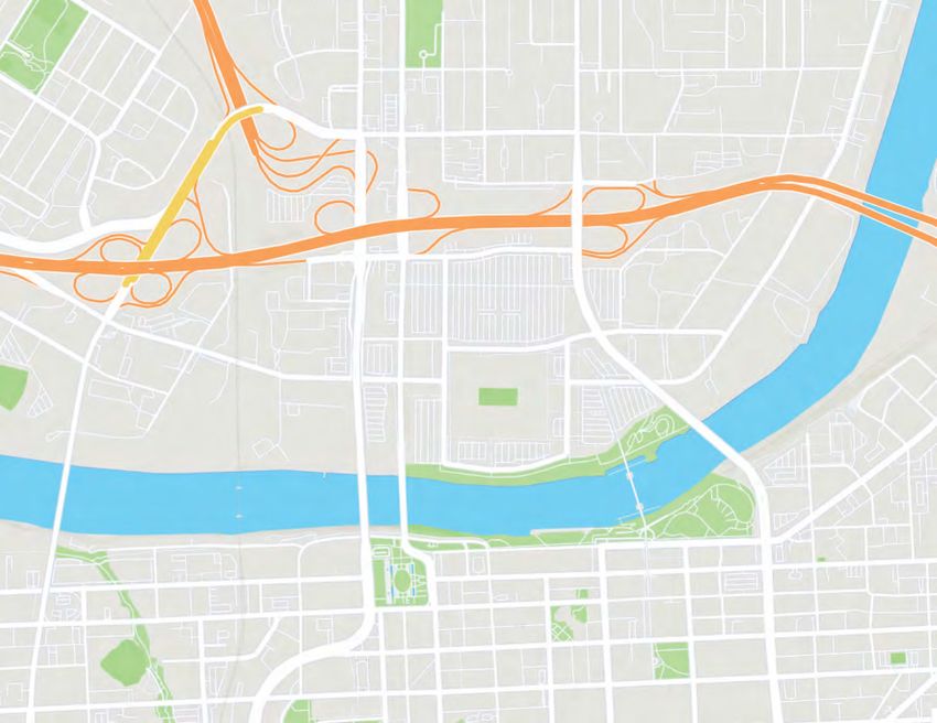
Breakdown of Totals Continued
                         eastbank

              playground facilities                 playground facilities
      price          land area     public revenue
                                                     10   5    1   1   1       1        1   1
                                                                                                                           $277
                                     generation      10   5    1   1   1       1        1   1       1
                                                                                                                              dollars
                                                     10   5    1   1   1       1        1   1       1                        allocated
                                                     10   5    5   1   1       1        1   1       1

                                                     10   5    5   1   1       1        1   1       1

                                                     10   5    5   1   1       1        1   1       1

                                                     10   5    5   1   1       1        1   1       1

                                                     10   5    5   1   1       1        1   1       1

                                                     20   10   5   1   1       1        1   1       1

                                                     20   10   5   1   1       1        1   1       1
                         eastbank

    public swimming area (or beach)                 swimming area
       price         land area   public revenue
                                                     10   5    1   1
                                                                            $261
                                   generation        10   5    1   1
                                                                             dollars
                                                     10   5    1   1        allocated
                                                     10   5    1   1

                                                     10   5    1   1

                                                     20   10   1   1
                                                                                                What We Missed
                                                     20   10   5   1                            In addition to the eight options
                                                     20   10   5   1                            provided, workshop attendees were
                                                     20   10   5   1                            given the option to write-in a type
                                                     20   10   5   1                            of public space that they would like
                         eastbank
                                                                                                the see in the East Bank area. These
                riverfront drive                    riverfront drive                            include:
      price          land area     public revenue
                                                     10   1
                                                                            $192
                                     generation      10   1
                                                                             dollars            Cultural Center
                                                     10   1                 allocated           Pier
                                                     10   1                                     Fishing
                                                     10   1                                     Cove
                                                     20   5                                     Nature Center
                                                     20   5                                     Children’s Museum
                                                     20   5                                     Plazas
                                                     20   10   1                                Batting Cages
                                                     20   10   1                                Boardwalk
                         eastbank
                                                                                                Bike repair station
                   dog park                         dog park                                    Rideshare pick-up/drop-off
      price          land area     public revenue
                                                     5    1    1   1
                                                                            $124                Homeless aide
                                     generation      5    1    1   1
                                                                             dollars            Greenways
                                                     5    1    1   1        allocated           Community Center
                                                     5    1    1   1
                                                                                                Transit Station
                                                     5    1    1   1                            Educational spaces
                                                     5    1    1   1                            Benches/seating
                                                     10   1    1   1                            Botanical Garden
                                                     10   1    1   1                            Canal
                                                     20   1    1   1

                                                     20   5    1   1

8   IMAGINE EAST BANK                                                      PLANNING + DESIGN PRINCIPLES PUBLIC ENGAGEMENT SUMMARY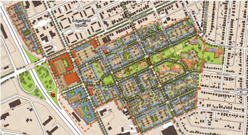
STATION 2 - AUTHENTICITY
  Station Instructions
  Station facilitators wanted to get an idea of which
  places workshop attendees thought were most
  authentic to Nashville. To do this, attendees were
  asked to consider the qualities of places that engender
  place attachment and what is missing from the urban
  fabric on the East Bank. The primary component of
  this station was a display board consisting of images
  highlighting various sites located throughout the
  county. Attendees were given five colored stickers
  and instructed to place one sticker on an image that
  evoked the following feelings:
        The place you take your family or go to be with friends...

        The most beautiful place...

        The place you got to relax or recharge...

        The place most in need of improvement...

        The place you go to celebrate...
  The images to the right show the full selection of
  locations attendees could place a sticker on.

  Summary and Results
  The top three scores from each of the five categories
  have been identified on the following pages and
  the bottom scores (those receiving 0 votes) have
  been listed. In the Red, Blue, and Green categories
  participants preferred sites that were parks or
  possessed abundant green space. In the Yellow
  category two out of the top three scores were
  historic sites and in the Orange category sites readily
  recognized as entertainment destinations claimed the
  top scores. It must be noted that sites that received
  some of the lowest scores tended to have civic or
  community-based functions.

  Verbal and written feedback showed that workshop
  attendees were generally in favor of continued
  development and growth occurring in Nashville but
  are concerned with maintaining the city’s authenticity.
  Themes of accessibility, affordability, and connectivity
  were indicators of public sentiment towards the topic
  of authenticity and the desired look and feel of it
  during the continuous transformation of Nashville’s
  cityscape.                                                         Note: See additional comments in Appendix A

PLANNING + DESIGN PRINCIPLES PUBLIC ENGAGEMENT SUMMARY                                          IMAGINE EAST BANK   9
THE PLACE YOU TAKE YOUR FAMILY OR GO TO BE WITH FRIENDS...

              five points                 shelby bottoms park and greenway                          cheekwood
             17 total votes                           12 total votes                                11 total votes
     places receiving 0 total votes: fort negley, margaret maddox ymca, east park community center, nashville public
                                            library (east), broadway, printers alley

   THE MOST BEAUTIFUL PLACE...

shelby bottoms park and greenway                        cheekwood                   nashville schermerhorn symphony
            27 total votes                              27 total votes                          12 total votes
   places receiving 0 total votes: ascend amphitheater and riverfront park, broadway, east park community center, five
                        points, nissan stadium, printers alley, sounds stadium, wedgewood houston

   THE PLACE YOU GO TO RELAX OR RECHARGE...

shelby bottoms park and greenway                      centennial park                   cheekwood / frist museum
            36 total votes                              24 total votes                       10 total votes each
                              places receiving 0 total votes: broadway, printers alley, the ryman

10 IMAGINE EAST BANK                                           PLANNING + DESIGN PRINCIPLES PUBLIC ENGAGEMENT SUMMARY
THE PLACE MOST IN NEED OF IMPROVEMENT...
historic jefferson street broadway fort negley
27 total votes 24 total votes 21 total votes
places receiving 0 total votes: ascend amphitheater and riverfront park, capitol view park, cheekwood, frist museum,
margaret maddox ymca, nashville public library (downtown), nashville schermerhorn symphony, the ryman, shelby
pedestrian bridge, sounds stadium, tennessee state museum, wedgewood houston
THE PLACE YOU GO TO CELEBRATE...
five points nissan stadium ascend amphitheater and riverfront park
19 total votes 12 total votes 12 total votes
places receiving 0 total votes: capitol view park, east park community center, fannie mae dees park (dragon park),
fort negley, historic jefferson street, margaret maddox ymca, nashville public library (east), tennessee state museum
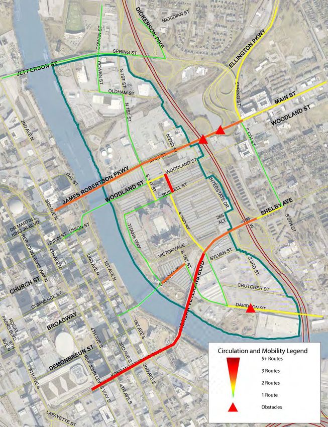
PLANNING + DESIGN PRINCIPLES PUBLIC ENGAGEMENT SUMMARY IMAGINE EAST BANK 11STATION 3 - CIRCULATION AND MOBILITY
Station Instructions the study area, the most trafficked area surrounds the
Metropolitan Nashville Juvenile Court (Woodland St,
Workshop attendees were asked to map the route Russell St, 2nd St, and 1st St).
they most often take through the East Bank with
yarn on a large aerial photograph of the study Attendees highlighted the intersections of Interstate
area. Station facilitators placed push pins at major Drive and the I-24 ramps and the connections to
intersections on which the yarn was strung. Attendees Spring Street and Ellington Parkway off Main St. as
placed variously colored push pins on destinations the most challenging areas near the East Bank study
within the study area and descriptive sticky notes area. A few attendees also indicated the awkward
explaining obstacles. intersection of Davidson Street and South 2nd Street
as a problem in this area.
Summary and Results
Note: See additional comments in Appendix A
Anticipating revision of the Major and Collector
Street Plan (MCSP) as the first action for the East Bank
Study, station facilitators aimed to understand the
connections through the study area, including what
streets are most commonly trafficked, where new
streets were necessary, and where major obstacles
exist.
The highest volumes of traffic through the study area
traced streets with connections across the River
(Jefferson St, James Robertson Pkwy, Woodland St,
and Korean Veterans Blvd.). Additionally, at every
workshop, attendees mapped usage of the John
Seigenthaler Pedestrian Bridge. These east-west
connections are the most important streets currently in
the study area.
While east-west connections are clear from community
engagement, north-south routes are muddled in the
study area. Routes across the four vehicular bridges
over the Cumberland River (Jefferson St, James
Robertson Pkwy, Woodland St, and KVB Blvd) split
into three different paths at the first intersection after
the River. Because neither 1st St. nor 2nd St. runs
through the entire study area, travelers through the
area must take different streets on the East Bank for
different parts of the study area. In two of the three
workshops, attendees did not indicate a single full
north-south connection through the site. The only
north-south route from a workshop that runs most of
the site requires four turns.
The busiest intersections in the study area are centered
around the three ramps on and off I-24. Although the
connections to I-24 are among the most frequented in
12 IMAGINE EAST BANK PLANNING + DESIGN PRINCIPLES PUBLIC ENGAGEMENT SUMMARYAggregate Map PLANNING + DESIGN PRINCIPLES PUBLIC ENGAGEMENT SUMMARY IMAGINE EAST BANK 13
Workshop 1 Map

14 IMAGINE EAST BANK   PLANNING + DESIGN PRINCIPLES PUBLIC ENGAGEMENT SUMMARY
Workshop 2 Map

PLANNING + DESIGN PRINCIPLES PUBLIC ENGAGEMENT SUMMARY   IMAGINE EAST BANK 15
Workshop 3 Map

16 IMAGINE EAST BANK   PLANNING + DESIGN PRINCIPLES PUBLIC ENGAGEMENT SUMMARY
STATION 4 -RESILIENT RIVER
  Station Instructions                                         curiosity about the levels of pollution in the river.
                                                               With memories of the May 2010 flood, fewer but
  Station facilitators provided two boards, at this station,   still a significant number of attendees, also indicated
  to workshop attendees. On the first board, attendees         concern with flooding of the river.
  were asked to place stickers next to things they
  associate the river with today. On the second board,         When asked to consider options for public investment,
  staff presented nine options for public investment           attendees favored opportunities for active recreation
  along the river, and attendees were asked which              along the river, including waterfront greenways
  options they would like to see.                              and walking paths. Additionally, waterfront dining
                                                               received a high number of votes. Little support was
  Summary and Results                                          given for beaches or swimming areas, but the lack of
                                                               support could be tied to the concerns voiced about
  The Cumberland River was identified as one of the            pollution.
  East Bank’s greatest assets. Any plans that emerge
  from this study should highlight the river as an             Just as flooding was the second most common concern
  economic and community resource.                             among attendees, green flood management strategies
                                                               were second most indicated desire for the East Bank.
  Workshop attendees associate the river today with            The results for specific flood mitigation approaches
  a barrier between Downtown and East Nashville.               received relatively equal votes, perhaps indicating
  Currently, there are few destinations in the East Bank.      a lack of knowledge by attendees about which is
  Attendees agreed that the river is an underutilized          appropriate on the Cumberland.
  economic generator. Not many attendees see the river
  as a recreational asset.
                                                               In addition to the formal voting process with sticker
                                                               dots, many attendees responded to many example
  Considering the current state of the Cumberland,
                                                               images. Many indicated a desire for methods of
  attendees indicated pollution as their number one
  environmental concern. Anecdotally, many indicated           getting onto the water, including personal boating
                                                               amenities and water taxis.

                                                               Note: See additional comments in Appendix A

PLANNING + DESIGN PRINCIPLES PUBLIC ENGAGEMENT SUMMARY                                            IMAGINE EAST BANK 17
How do you see the Cumberland River in Nashville today?
division
between
Downtown
and East Side
42 total votes
underutilized
economic
generator
41 total votes
industrial
waterway
32 total votes
inaccessible
to the public
29 total votes
pass over
on my way
somewhere
else
26 total votes
recreational
asset
25 total votes
0 10 20 30 40
Workshop1 Workshop 2 Workshop 3
1. Division between Downtown and East 2. Underutilized Economic Generator
This perception was attendees’ most selected at two of This perception was attendees’ most selected at one
the three workshops. As few community destinations of the three workshops. Although industrial uses are
are located in the East Bank, many feel that this void prominent on the East Bank, a significant amount of
divides vibrant areas of the city. the study area is consumed by parking lots.
18 IMAGINE EAST BANK PLANNING + DESIGN PRINCIPLES PUBLIC ENGAGEMENT SUMMARYWhat environmental concerns do you share about the Cumberland River?
pollution
49 total votes
flood hazard
31 total votes
loss of native
habitat
23 total votes
steep,
eroded
banks
12 total votes
0 10 20 30 40
Workshop1 Workshop 2 Workshop 3
1. Pollution 2. Flood Hazard
Pollution was attendees’ number one environmental Flood Hazard was attendees’ second most selected
concern at every workshop. People said that they environmental concern at every workshop. Much of
were worried about pollution but did not know much the study area is in a flood plain, and the tragic May
about the existing water quality. 2010 Nashville Flood is still on citizens’ minds.
PLANNING + DESIGN PRINCIPLES PUBLIC ENGAGEMENT SUMMARY IMAGINE EAST BANK 19What would make the river more appreciated as a community resource?
waterfront dining and
viewpoints
50 total votes
waterfront greenways
45 total votes
stormwater filtering
37 total votes
walking paths
34 total votes
kayaking and boating
facilities
28 total votes
places designed to
flood
Interaction with River
Active Opportunities
28 total votes
Flood Management
native riparian
plantings
26 total votes
family-friendly water
interaction Workshop 1
22 total votes
Workshop 2
beaches or swimming
areas Workshop 3
9 total votes
0 10 20 30 40 50
1. Waterfront Dining and Viewpoints 2. Waterfront Greenways
This amenity was attendees’ most selected across the This amenity was attendees’ second most selected
three workshops. People think that views across the across the three workshops. Many people enjoy the
Cumberland River back towards downtown are an existing walkways adjacent to the river and want
asset that the East Bank should take advantage of. to see them expanded (to River North, and Shelby
Park), and enhanced (with proper greenways, native
plantings, etc.)
20 IMAGINE EAST BANK PLANNING + DESIGN PRINCIPLES PUBLIC ENGAGEMENT SUMMARYSTATION 5 - PLANNING + DESIGN PRINCIPLES
Station Instructions
Station facilitators sought the public’s assistance in
helping to determine the appropriate planning and
design principles needed for guiding development of
the East Bank. The activity centered around a set of
questions dealing with the past, present, and future of
Nashville and the East Bank. The questions were as
follows:
1. Use three words to describe what your
grandparents would be surprised to learn
about Nashville today (or what Nashville was
like generation ago)
2. Use three words to describe the East Bank
today
3. Use three words to describe how you want
future generations to experience the East Bank
in 50 years
Summary and Results
This station provided valuable insight into the public’s
desired vision on what approaches to incorporate
when planning and designing for the East Bank. The
following response captured the essence of what these
responses said: “incorporate people who currently live
in the community in the considerations of design”. The
key word here being people, and prioritizing the need
to not overlook the human element as design and
planning principles are being developed for the East
Bank.
A word cloud graphic for each of the three questions
was generated to show the most common words/
phrases appearing in attendees responses. When
speaking about the past, responses from attendees
contrasted between positive and negative. This same
trend was seen in attendees’ responses regarding the
perceived present status of the East Bank. Responses
to question three provided a clear sign of the level of
optimism expressed by attendees about the future of
the East Bank. The three word clouds are presented on
the next page.
Note: See additional comments in Appendix A
PLANNING + DESIGN PRINCIPLES PUBLIC ENGAGEMENT SUMMARY IMAGINE EAST BANK 21What would your grandparents be surprised to learn about Nashville today? 22 IMAGINE EAST BANK PLANNING + DESIGN PRINCIPLES PUBLIC ENGAGEMENT SUMMARY
Describe the East Bank today?

PLANNING + DESIGN PRINCIPLES PUBLIC ENGAGEMENT SUMMARY   IMAGINE EAST BANK 23
Describe how you want future generations to experience the East Bank?

24 IMAGINE EAST BANK                  PLANNING + DESIGN PRINCIPLES PUBLIC ENGAGEMENT SUMMARY
STATION 6 - LAND USE MIX
Station Instructions
Station facilitators provided workshop attendees
with their own map of the East Bank separated into
three potential districts - South of Shelby, Central
Waterfront, and North of Main. They were asked to
place various land use stickers on the map in the areas
they would most want to see those land uses located.
The map and land use stickers are pictured below.
Summary and Results
Overall, attendees placed the most dense land use
types within the Central Waterfront district. These
ranged from low-rise mixed-use near the waterfront,
and high-rise mixed-use near the interstate. Less
intense uses such as townhouses and live-work units
were most often placed in the North of Main and
South of Shelby neighborhoods. While much of the
East Bank is currently industrial, people envision the
future of the East Bank as less industrial and more
mixed-use - Industrial stickers were primarily placed
within the South of Shelby neighborhood.
Note: See additional comments in Appendix A
Park
Parkway
Terrace
Low-Rise Mid-Rise
(MDHA)
High-Rise East
Low-Rise Mid-Rise High-Rise CayceIndustrial Townhouses Live-Work
Mixed-Use Mixed-Use Mixed-Use Park
Flats Edgefield Flats Flats
S 6th St
Place
McFerrin Park
Shelby Ave
S 5th St
Above: Series
S 4th St of stickers that
attendees were
provided with at
this station
St
River’s
Edge
South
er
St
ch
on
of Shelby
ut
ds
150
Central
Cr
0ft
vi
an 1500ft
Da
St
Waterfront
Juvenile S 2nd St
Detention
Center CITGO Left:
RolMap of
Victory Ave
Main St
North Nissan
three potential
St
Woodland St
Russel St
of Main Stadium Mill that
Main St
rson
150
0 ft K
.V
districts
attendees were
Jeffe
.B
Titan s Way provided with at
this station
Cumberland River
PLANNING + DESIGN PRINCIPLES PUBLIC ENGAGEMENT SUMMARY IMAGINE EAST BANK 25
SobroS 4th St
Sh
Note: Map shows the So
00f
approximate location
Central
of where stickers were of
t placed. The taller the bar,
Waterfront
the more stickers were
placed in the location. A
registers onSthe
bar only Juvenile 2nd St
Detention
map when Center
more than three
Victory Ave
M a i n S t stickers were placed in that
North location. Nissan
St
Woodland St
Russel St
of Main Stadium
Main St
rson
150
0 ft
Jeffe
Titan s Way
Industrial
industrial Cumberland River
7 total votes
North of Main
Mid-Rise
mid-rise flats Flats In the North of Main area, workshop
12 total votes attendees used the Low- and mid-rise
mixed-use, and live-work stickers the most.
Low-Rise
Flats
Generally, low-rise mixed-use was placed
low-rise flats
15 total votes Downtown closer to the river, and mid-rise closer to the
interstate. Live-work stickers were placed
High-Rise
throughout the area. Additionally, low-rise
high-rise mixed-use
STATION 6:total
LANDMIX
Mixed-Use
flats and townhouses were placed near the
15 votes river. There were very few industrial land use
stickers placed in this area.
High-Rise
Flats
high-rise flats
18 total votes Note: Bar chart shows the
total amount of stickers
Townhouses placed in this district.
townhouses
21 total votes
Low-Rise
Mixed-Use
low-rise mixed-use
27 total votes
Mid-Rise
Mixed-Use
mid-rise mixed-use
32 total votes
Live-Work
live-work
38 total votes
0 10 20 30 40
26 IMAGINE EAST BANK PLANNING + DESIGN PRINCIPLES PUBLIC ENGAGEMENT SUMMARYS 4th St
Sh
Note: Map shows the
approximate location
St
St
River’s of where stickers were River
Edge Edg
outh
er
South
er
St placed. The taller the bar,
St
ch
ch
the more stickers were
on
on
f Shelby
ut
of Shelby
ut
placed in the location. A
ds
ds
Central
Cr
Cr
bar only registers on the
vi
vi
1500ft map when more than three
Da
Da
Waterfront stickers were placed in that
location.
Juvenile S 2nd St
Detention
CITGO Center CITGO
Victory Ave
h Main St
Rol Nissan
Woodland St
Russel St
ain Mill Stadium
Main St
150
K 0 ft K
.V .V
.B .B
Titan s Way
Industrial
industrial Cumberland River
6 total votes Central Waterfront
Low-Rise
In the Central Waterfront area, mixed-use land uses
low-rise flats Flats
were the overwhelming majority. All three scales
12 total votes of mixed-use are desired. High-rise mixed-use was
concentrated near the interstate with low-rise near the
high-rise flats
Sobro High-Rise
Flats river. Some mid- and high-rise flats were placed near So
15 total votes Downtown the interstate as well.
Townhouses Industrial uses, townhouses, and low-rise flats stickers
townhouses were not placed in one area enough to appear on
X 16 total votes
the map.
Music Mid-Rise
Flats
Music
Note: Bar chart shows the
City mid-rise flats
24 total votes
total amount ofCity
stickers
placed in this district.
Live-Work
live-work
33 total votes
Low-Rise
Mixed-Use
low-rise mixed-use
57 total votes
Mid-Rise
Mixed-Use
mid-rise mixed-use
61 total votes
High-Rise
Mixed-Use
high-rise mixed-use
63 total votes
0 10 20 30 40 50 60
PLANNING + DESIGN PRINCIPLES PUBLIC ENGAGEMENT SUMMARY IMAGINE EAST BANK 27Shelby Ave
S 5th St
Note: Map shows the S 4th St
approximate location
of where stickers were
placed. The taller the bar,
the more stickers were
placed in the location. A
St
bar only registers on the River’s
Edge
South
er
St
map when more than three
ch
stickers were placed in that
on
of Shelby
ut
location.
ds
Central
Cr
vi
1500ft
Da
Waterfront
Juvenile S 2nd St
Detention
Center CITGO
Victory Ave
Main St
Nissan
Woodland St
Russel St
Stadium
Main St
150
0 ft K
.V
High-Rise .B
Flats
high-rise flats
13 total votes Titan s Way South of Shelby
High-Rise
Mixed-Use
South of Shelby, live-work and townhouses
high-rise mixed-use were the most commonly placed stickers.
18 total votes Cumberland River
These were most often placed along the
Low-Rise
interstate. Low- and mid-rise mixed use were
low-rise flats Flats
most often placed along the river. High-rise
19 total votes buildings are the least desired land use type in
this area.
Sobro
Mid-Rise
Flats
mid-rise flats
21 total votes Of the three areas identified in the Land Use
Downtown Mix workshop station, the South of Shelby
Industrial area had the most Industrial stickers placed in
industrial it.
21 total votes
Note: Bar chart shows
Low-Rise the total amount of
low-rise mixed-use Mixed-Use Musicstickers placed in this
22 total votes City district.
Mid-Rise
Mixed-Use
mid-rise mixed-use
24 total votes
Townhouses
townhouses
30 total votes
Live-Work
live-work
38 total votes
0 10 20 30 40
28 IMAGINE EAST BANK PLANNING + DESIGN PRINCIPLES PUBLIC ENGAGEMENT SUMMARYerrinNote:
Park
Shelby Ave
S 5th St
Map shows the approximate location of where stickers were placed. The taller
the bar, the more stickers were placed in the location. A bar only registers on the map
when more than three stickers were placed in that location.
S 4th St
St
River’s
Edge
South
er
St
ch
on
of Shelby
ut
ds
Central
Cr
00f
vi
t 1500ft
Da
Waterfront
Juvenile S 2nd St
Detention
Center CITGO
Victory Ave
Main St
North Nissan
St
Woodland St
Russel St
of Main Stadium
Main St
rson
150
0 ft K
.V
Jeffe
.B
Titan s Way
Cumberland River
East Bank
Industrial
As a whole, the East Bank is desired
industrial
34 total votes to be a mixed-use district. Workshop
attendees typically placed less intense
land use types (such as live-work,
Sobro
Low-Rise
Flats
low-rise flats townhouses, and low-rise mixed-use
46 total votes Downtown and flats) near the Cumberland River.
High-Rise
They placed more intense land uses
STATION 6:high-rise
LANDMIXflats Flats
(such as mid- and high-rise mixed use
46 total votes and flats) near the interstate.
Music
Note: Bar chart shows the total
City
Mid-Rise
Flats
amount of stickers placed in the three
mid-rise flats districts combined. The first segment
57 total votes of each bar represents the North of
Main district; the middle segment
Townhouses represents the Central Waterfront
townhouses district, and the last segment
67 total votes represents the South of Shelby district.
High-Rise
Mixed-Use
high-rise mixed-use
96 total votes
Low-Rise
Mixed-Use
low-rise mixed-use
106 total votes
Live-Work
live-work
109 total votes
Mid-Rise
mid-rise mixed-use Mixed-Use
117 total votes
0 20 40 60 80 100 120
PLANNING + DESIGN PRINCIPLES PUBLIC ENGAGEMENT SUMMARY IMAGINE EAST BANK 29ONLINE SURVEY RESULTS
Planning staff also crafted an online survey to mirror Nearly a majority of respondents (47%) visit the East
the in-person activities at the July 14th and 15th Bank monthly, while almost no respondents (2%)
workshops. While the survey was available online never visit. Although few seem to often visit the study
from July 14th through July 23rd at eastbankstudy. area, many attend events on the East Bank or travel
nashville.gov, 605 people participated in the through it. A large majority of respondents travel
survey. Every question was answered by over through the East Bank weekly (32%) or monthly
500 participants, and 282 people said they were (30%), emphasizing the area’s importance as a
interested in future participation in East Bank planning. regional connection.
Participants Like workshop participants’ desire for trails, survey
respondents indicated that parks (438 votes) and
Over half of the respondents (59%) lived in Metro greenway connections (418 votes) were priorities for
Nashville, but very few (4.5%) work or own property the study area. Further underscoring respondents’
in the East Bank. A majority (52%) of respondents want for parks and open space, when asked how they
were between 26 and 40 years old while few thought of the East Bank today, 70% of respondents
respondents (9%) were over 70 years old or younger said it was an opportunity for new parks. Although
than 25. Respondents were overwhelmingly white respondents want a opportunities to interact with the
(83%), and only 6% were black, African-American, river, currently 75% of respondents do not participate
Hispanic, Latino, or of Spanish Origin. Respondents in any activities involving the river.
were also majority male (54%).
Currently, respondents said that interstate congestion
The top five respondent-identified neighborhoods in the area and lack of walking/biking amenities were
indicated by survey respondents were all in East the largest issues in the study area, emphasizing the
Nashville near the study area, indicating heavy importance of changes to the circulation patterns in
participation by neighboring communities. the area.
Summary and Results Highlighting respondents commitments to increased
mixed-use development, live-work and mid-rise
Similar to the in-person workshops, the online survey mixed-use were the most commonly indicated land
focused public spaces, authenticity, circulation, the uses for the East Bank. Industrial received the fewest
river, and potential land-uses. votes.
Planning staff asked about the current conditions of
the East Bank, particularly where respondents go in
the study area and what the areas largest asset is.
Planning staff provided options, responses to these
two questions were very similar. When they come
to the East Bank, the most people said that they
attended an event at Nissan stadium with Cumberland
Park in a close second. Respondents also named
Nissan Stadium and Cumberland Park the areas
most valuable assets. The John Seigenthaler Bridge,
Cumberland River, and parking in that order rounded
out the top five most common destinations and most
valuable assets.
30 IMAGINE EAST BANK PLANNING + DESIGN PRINCIPLES PUBLIC ENGAGEMENT SUMMARYQ1. What is your interest in the study area? (users selected all that applied)
resident of Metro 357
Nashville
regular visitor to the
East Bank 260
resident of East
Nashville 253
property owner in 243
Metro Nashville
property owner in 185
East Nashville
Other 54
developer, investor,
or real estate 47
professional Total Respondents:
605
employee of a
company on the East 18 Average Responses:
Bank 2.36
Skipped: 0
property owner in 9
East Bank
0 90 180 270 360
Q2. If you are a resident of Metro Nashville, where do you live?
East Nashville 76
Inglewood 45
Eastwood 22
Lockeland Springs 19
Cleveland Park 18
0 20 40 60 80
PLANNING + DESIGN PRINCIPLES PUBLIC ENGAGEMENT SUMMARY IMAGINE EAST BANK 31Q3. What is your age?
26-40
51.5% 18-25
Other/Perfer not to answer
6.31%
1%
Over 70
56-70 2.66%
15.12%
41-55
23.26%
Q4. Which of the following best describes your racial or ethnic identity?
Other
0.50%
White
83.08%
Hispanic, Latino, or Spanish
2.32%
Perfer not to
answer
7.30% Black or African American
3.81%
Q5. Which of the following best describes your gender?
Male
54.47%
None of the above
0.33%
Perfer not to answer
3.48%
Female
41.72%
32 IMAGINE EAST BANK PLANNING + DESIGN PRINCIPLES PUBLIC ENGAGEMENT SUMMARYQ6. When you come to the East Bank area, what is your destination?
(multiple answers allowed)
1. Event at Nissan Stadium 2. Cumberland Park 3. John Seigenthaler Bridge
372 total votes 364 total votes 295 total votes
4. Cumberland River 5. Stadium Parking 6. Other
202 total votes 192 total votes 84 total votes
Q7. How often do you come to the East Bank currently?
monthly
280 total votes
weekly
159 total votes
yearly
77 total votes
daily
72 total votes
never
13 total votes
0 60 120 180 240 300
Q10. How often do you drive (or bike or walk) through the East Bank?
never 6%
daily yearly monthly weekly
8% 24% 30% 32%
PLANNING + DESIGN PRINCIPLES PUBLIC ENGAGEMENT SUMMARY IMAGINE EAST BANK 33Q9. What amenities would encourage you to visit the East Bank more often?
Parks 438
Shops and
restaurants 429
Greenway
conections 418
Recreational oppor- 368
tunities
Better river access 357
Entertainment 343
institutions
Transit connections 221
Diverse housing 148
opportunities
Well-paying jobs 34
Other 34
0 90 180 270 360 450
Q8. What is currently the East Bank’s greatest asset?
1. Nissan Stadium 4. Cumberland River
173 total votes 104 total votes
2. Cumberland Park 5. Plenty of parking
166 total votes 22 total votes
3. John Seigenthaler Bridge 6. Other
126 total votes 13 total votes
34 IMAGINE EAST BANK PLANNING + DESIGN PRINCIPLES PUBLIC ENGAGEMENT SUMMARYQ11. What are circulation challenges you encounter on the East Bank?
Interstate congestion 345
Lack of walking/biking
amenities 334
Danger to pedestrians 319
Lack of Greenway 273
connections
Danger to cyclists 271
Confusing street 209
connections
Difficulty accessing
downtown 195
Lack of transit
181
connections
Other 47
None of the above 20
0 70 140 210 280 350
Q12. How do you think of the Cumberland River in Nashville
as it exists today?
1. Opportunity for public parks 2. Forgotten part of our city 3. Recreation source
425 total votes 351total votes 246 total votes
PLANNING + DESIGN PRINCIPLES PUBLIC ENGAGEMENT SUMMARY IMAGINE EAST BANK 35Q13. What activities do you partake of activities on the river
from the East Bank?
None Fishing
74.58% 2.01%
Boating
3.68%
Other
5.02%
Kayak, canoe, paddleboard
14.72%
Q14. What land-uses do you think would create a successful
East Bank in the future?
Live-Work
live-work: 323 total votes
Mid-Rise
Mixed-Use
mid-rise mixed-use: 306 total votes
Low-Rise
Mixed-Use
low-rise mixed-use: 279 total votes
High-Rise
Mixed-Use
high-rise mixed-use:188 total votes
Mid-Rise
Flats
mid-rise flats:134 total votes
High-Rise
Flats
high-rise flats:111total votes
Townhouses
townhouses: 110 total votes
Other other: 90 total votes
Low-Rise
Flats
low-rise flats: 79 total votes
Industrial
industrial: 25 total votes
0 70 140 210 280
36 IMAGINE EAST BANK PLANNING + DESIGN PRINCIPLES PUBLIC ENGAGEMENT SUMMARYQ15. 50 years from now, how do you want your grandchildren to be able to describe the East Bank? Q16. What are the greatest challenges to achieving this vision? PLANNING + DESIGN PRINCIPLES PUBLIC ENGAGEMENT SUMMARY IMAGINE EAST BANK 37
APPENDIX A - WORKSHOP COMMENTS
  Station 2 Comments                                               new; I want experiences that are unique
                                                                   9. Ease of access; views & unique events/
  Workshop 1                                                       experiences; interesting architecture – not cookie
  1. Music (types, schedules, buskers, bands)                      cutter ugly buildings
  2. Impact of sidewalk cafes (which are overdue) on               10. Sustainable, unique, & sturdy built buildings; don’t
  Riverfront Park on W.                                            need wood, sheet, pre-fab building(s) that are ugly
  3. Focus on use vs aesthetic                                     11. A place to spend time
  4. Maintain building scale relative to other                     12. Seriously need a dock for boaters to come to
  community/entertainment districts                                Nashville for events, dinner, touring, etc., without
  5. Distillery District similar to Lexington focusing on          having to make reservations well in advance AGLCA
  small local businesses                                           Loopers have a poor perspective of Nashville
  6. A public gathering place that provides a mix of               because of a decent place to dock!
  uses and draws ala DC’s Yards Park, Greenville, etc. –           13. References to the things places that make
  current Nashville has no place where people can just             somewhere great (local restaurants in the G & Broad
  walk around                                                      development is a great example)
  7. Homeless is in the top reasons for all the pollution in
  the river                                                        What is missing from the fabric of the East Bank?
  8. We don’t need another downtown make this space                14. Café/coffee
  work for all the people who live here                            15. People, area seems cut off from population
  9. Keeping, maintaining, and supporting African                  16. Marina, restaurants, shopping
  American historic centers without just having a “Black           17. Anything more than single point destination;
  Face” with white ownership & control                             anything walking/bike (other than car)
  10. Actually countering gentrification & displacement            18. Easy access-its different to get to East Bank from
  11. Access to mass transit – WEGO                                East Nash on bike or foot
  12. Community canvassing to further assess                       19. Get rid of the giant parking lots
  13. Re-incorporating communities that have been                  20. Housing; affordable housing and workforce
  gentrified out of the city                                       housing with amenities for residents, not tourists
                                                                   21. Community input!; Metro needs to involve them!
  Workshop 2                                                       (not exclude them)-Slow down!-give the community
  What are the qualities of places that engender place             time to respond-a lack of transparency is inauthentic
  attachment?                                                      22. Marina access; fueling for boats of all sizes
  1. Historic content-view                                         23. Homeless affordable housing communities > tiny
  2. Workforce that actually wants to be there – people            houses
  who are taken care of & can easily access their jobs             24. Jobs for people who live nearby in this community
  3. Housing filled w/ people who represent this city’s            that pay a living wage, 49% of households in
  history                                                          Davidson Co are employed, making more than
  4. People who live here, that will drive what they want          poverty wages still struggling to get by w/ housing
  and need                                                         costs & other costs of living
  5. Ease of access/ability to visit frequently; green             25. Move housing & places to build a living, breathing
  space; interesting views (indoors & outdoors);                   community especially affordable housing is essential
  beautiful & engaging architecture                                that we have housing for everyone in Nashville and
  6. Places & ways to keep people                                  affordable as in housing for incomes at or below
  ?????????????????????                                            $60,000 year ??? median income
  7. Architecture that serves/fits it’s setting                    26. Dining, music, water access
  8. Local businesses. I do not want to see chain coffee           27. Affordable housing is being destroyed – prob.
  shops, stores or restaurants; I do not want to feel like I       Is only going to increase if mixed-use, including aff.
  could be in any other city; I want to be surprised and           housing is a part of every build. (I see good jobs
  delighted; I want to discover; I want to try something           coming-let’s recruit, train, employ local people for

38 IMAGINE EAST BANK                                           PLANNING + DESIGN PRINCIPLES PUBLIC ENGAGEMENT SUMMARY
these jobs that pay enough so people can afford to draw other than big games (DEER DISTRICT
live here) MILWAUKEE)
28. Keep party buses out of new development 21. Shade trees/habitat to remediate flood/run-off
29. Focus on Nashvillian amenities (to much priorities 22. Access by any way other than a car, to the water
to tourism)-move amphitheater or into the area from outside highway
23. Restaurants, green spaces (non-industrial)
Workshop 3 24. Restaurants, event space, safe docking/marina
What are the qualities of places that engender place 25. Marina to dock a boat & eat at a restaurant on
attachment? the water
1. Connection to the waterfront -aka Riverwalk like 26. Mixed use spaces, transportation, playgrounds
San Antonio (Cumberland Park is not reliable), affordable housing
2. Historical perspectives-a recognition of the past 27. Civic gathering space
and what has come before
3. They have something new & unique-not just created Station 3 Comments
just to attract visitors, tourists, bridal weekends; places
Nashvillians would like to visit Workshop 1
4. Coming downtown by boat with my family to view 1. Parking Opps outside of downtown with transit
the fireworks access (last mile) *(close by destinations) *
5. Casual non-commercial venues for frequent relaxed 2. EV Charging availability
visits 3. Beautification of Interstate Bridge
6. Historic neighborhoods and landmarks – buildings 4. Keep in mind access needs (strollers, wheelchairs,
that look older than a couple years; public spaces etc.) [ADA]
at regular intervals, connected to a mix of uses and 5. Street Trees (shading) and Street Furniture
mixed income residences Local and Regional Mobility (WeGo amenities)
7. Ability for some construction to not just be large 6. Light Rail (Minneapolis)
corporate development – individual ownership 7. Access Points for Interstate (consolidation)
8. Scale, character, activities & public space, easy to - Main and Woodland
get to-connected 8. Interstate to Boulevard
9. Natural landscape, walkability, human scale, 9. Walk, Bike, Transit Priority
accessibility, visual scan identifying diverse activities 10. Access in and through during events
of things to do or see 11. Access to water during events (Special events
10. People on shore like to watch boats go by! creates barrier)
11. Foster community (libraries, parks, outdoor dining, 12. Access for Service workers/employees of East
etc.); owned by/staffed by/driven by locals (I think of Bank
Grimeys) 13. Special Events as barriers for locals
JSBridge Land sooner, connections, more bike/ped
What is missing from the fabric of the East Bank? Road + Floodplain Issues
12. Accessibility for those w/ limited physical capacity
13. Affordable business space for small, women- Workshop 2
owned and minority businesses (real small business 1. Special Events = Barrier for locals
not IRS definition of small) 2. Transit and Transit Center
14. Plan for affordable housing 3. Opportunities to avoid downtown
15. Restaurants 4. Mass Transit for special events (COVID testing site
16. Quiet places off of Shelby?)
17. Safe docking space for family boating, games, 5. Public Art opportunities
events, etc. (both transient docks and marina slips) 6. Streetcar opportunities connecting site to downtown
18. I don’t see any spaces for small businesses, and Tram opportunities = fun
current minority owned businesses, local or community 7. Monorail opps
centers Bike – Ped opps, Greenway too!
19. Connectivity 8. Prioritizing needs of locals/residents, not only
20. Non-sport venues to complement game day; tourists
PLANNING + DESIGN PRINCIPLES PUBLIC ENGAGEMENT SUMMARY IMAGINE EAST BANK 399. Know who we are (authenticity) trees that are there now
10. Transit for workers-enhance WeGo routes – on 7. Current Greenway Structure/interaction
and off peak (24/7) 8. Homeless Communities along river side
11. For those that need it and work here Affordable housing (income does not keep up with
12. Old Trolley/Streetcar routes – might be good wages here!)
starting point for new routes 9. Providing well paying jobs with developments on
river
Workshop 3 10. Streams and waterways built into public spaces
1. Industrial bicycle facilities conflict on Davidson with stone steps, concrete ramps, wetland plants and
Bad intersections at Main and I-24 and Spring St. draining structures. Similar to the existing concrete &
2. Circulation of boat traffic (including raising hillside structures at Riverfront Park
awareness of recreational usage of river) 11. Ancient structures in India, on the Ganges River
3. Resiliency could be a model.
4. Affordable, public transit (now) (rapid transit)
5. Accommodates accessibility needs Workshop 2
6. More bus routes 1. I would never swim in this river, as is. Do we know
7. More reliable bus routes the major pollutants? If not, why not? Do we have
8. More accessible footpaths (sidewalks, greenways, plans to improve the quality of the water? If not, use
bike) our major colleges and universities to develop plans.
9. Train tracks – repurpose 2. We need to make sure we have lots and lots of
10. Different transit vehicles green space to reduce river flooding, and we need
11. River taxis (river north, open land area) Local ways to prevent and deter polluters.
residents 3. I would love to see more recreational access to the
12. Focus on transportation tripping hazards river, canoes, kayaks, paddleboats. I would love to
13. Safe docking areas in between bridges (but not see more waterfront dining and relaxation places.
right beside) 4. We need marinas and services for boating.
14. Security at docks 5. Please make access to downtown events, dining,
15. Moving sidewalks on the hills downtown etc. to boaters without reservations or long-range
16. Be able to bike, walk to areas safer planning.
Narrow sidewalks on bridges & no railings 6. There are no good docks presently for transit
17. Commute biking focus boaters (“Loopers”). Need more dock space for
18. More ped & bike infrastructure (across the river) Titan’s games.
19. More reliable transportation options 7. An expansive boardwalk would be great. The
20. Parking (street parking, surface lots, garages) Malecon in Puerto Vallarta is a good example – full
of public art, street merchants, and a wide mix of
Station 4 Comments commercial and residential uses.
8. At the river’s edge, and at engineered streams/
Workshop 1 tributaries having built forms, stone steps, architectural
1. Today: Hundreds of homeless living along the River features that can be partially submerged in heavy
fronts visible trash polluting the water. rain and flooding would be iconic and beautiful
2. Removable flood walls landmarks.
3. Sewer outflow downtown in poor water quality 9. Slow down the study, so that we can involve/
that is currently rated as unsafe for recreation. Would engage the communities affected! No need to rush it,
like for this to be fixed so that recreation is safe do it right.
and healthy at River North, lock one, Neuhoff, at
downtown of Broadway generally. Workshop 3
4. Add areas to dock private canoe/kayak/paddle 1. I spent a week in Geneva, Switzerland visiting
board to encourage blue commute. CERN. The water taxis were wonderful and a unique
5. Make it easier to find water quality data and have aspect/addition to the fantastic public transit. Cheap.
it available 24/7 Unique. As were the public path houses built out on
6. Program riverbanks rather than the random wrecks/ the lake. Many with additional offing/drinks/showers.
40 IMAGINE EAST BANK PLANNING + DESIGN PRINCIPLES PUBLIC ENGAGEMENT SUMMARY2. Michigan Ave. in Chicago could be a model and to address our mass transit infrastructure needs.
for how to align a strong corridor of architecturally 6. Jobs for local residents that pay a LIVING WAGE
valuable buildings along a linear park and water. $17+/hr., People in Nashville should be able to
3. “Authenticity” – Preserve commercial use of river afford to live close to where they work.
Chattanooga is 30 years ahead of us 7. Please keep building “Low Rise” on the East Bank!
4. (Boaters) Need protection from pedestrian garbage 8. The idea of a future MLB Park should be
5. Would love to see more of (boating) abandoned, Metrocenter is a better site for an MLB
6. Titan’s Navy stadium.
9. We need connected density! Connected to
Station 5 Comments downtown (river is not a national border) add to
housing stock, incubator business spaces. Walkable/
Workshop 1 ridable districts, keep cars to an absolute minimal
1. Multimodal transportation…WEGO must be a (limited to no parking minimums)!
priority. Lyft, Uber ??? 10. Relocate the Juvenile Justice Center
2. Are there any plans/efforts to clean the river up? 11. Connect Shelby Park to the Lock One Park North
(the actual water/bank) of I-65 via extended Greenway
3. The Mayor of Nashville (Cooper) promised that 12. Nashville needs walkable areas where residents
affordable housing would be a central part of all can access GOOD JOBS near their homes. Mayor
coming developments – we don’t see this in the East Cooper promised affordable housing would be an
Bank Plan. integral piece in planning future developments. East
4. Tram across river to connect more parking options Bank must provide affordable housing among its
to downtown for Bridgestone/Convention center developments.
events. 13. More affordable housing: of the 5 census tracts
5. Buses, bikes, WeGos-all great. BUT, some families bordering the study area 1 had B/W 12- 18% of
need to use personal vehicles. Young fam’s w/ small residents living below the poverty & had B/W 18-
kids w/ strollers, diaper bags, food pods, etc., AND 24% and 1 had B/W 24+ 72.5%
older folks w/ wheelchairs, etc.-???...on site parking 14. Ditto on affordable housing. Be aware of
& level pathways for those. affordable housing. This project might destroy
6. Potential for DTC 2.0 in central waterfront. affordable housing on the border of this project that
7. Workforce development as plans are created, how might be gentrified. Do no harm.
can this plan be an investment in Nashville workforce. 15. As more buildings go up this will continue to be
8. Maintain scale of Cayce Place in “South of the best vantage to observe Nashville’s iconic skyline.
Shelby”. All developments should be oriented to preserve and
celebrate the view.
Workshop 2 16. Housing that regular people can afford-especially
1. ??? of mixed use development; it’s essential we the people who will work in future East Bank
have mixed income housing & businesses (e.g. In ??? businesses. People should be able to walk to their jobs
building units for affordable housing & ??? business in the neighborhood.
locations, have spaces decided for ??? businesses 17. Yes – affordable housing; employ local residents,
based in Nashville on top of spaces for larger have unions provide training for local workers, pay
buildings living wage $17+ hour! We can do this!
2. Basics: small scale, no apartments, condo and/ 18. Incorporate people who currently live in the
or single family so people invest!, work/live co-op… community in the considerations of design. Don’t rush
follow basics. Trees/sidewalks/public, semi-public, planning that’s one-sided because it’s uncomfortable
semi-private or will “Slow Things Down”. Intentional, meaningful
3. Bike lanes! approaches.
4. Build for adaptive re-use. Buildings cannot be
obsolete in 30-50 years Workshop 3
5. Great opportunity to use areas close to downtown 1. Water activities should appeal to those from all
business district to address our need for housing (can income status
be full value/doesn’t have to be affordable range) 2. How many services can be packed into a single
PLANNING + DESIGN PRINCIPLES PUBLIC ENGAGEMENT SUMMARY IMAGINE EAST BANK 41city block? Small business incubators. Market rate
commercial space. Affordable & mixed income
housing. Multimodal transit centers. Public art. Green
space. Urban farming. Childcare. Assisted living.
Community centers. Schools-stack them all together!
As many as possible.
Station 6 Comments
Workshop 1
1. Cultural hub – authentic places where people of
other cultures feel comfortable gather; museum r other
cultural program.
2. How do you really create housing that is attainable
for all?
3. What will the market demand?
Workshop 2
1. 19.5 % of homeowners & 46.5% of renters in state law.
Nashville spend more than 30 % of their income on 2. Prioritize racial and economic equity through
housing ; median income for Nashvillians over 25 affordable housing and affordable commercial spaces
with only a high school degree was $29,168. Future for women and minority and small businesses.
development should provide affordable housing that is 3. Development should require hiring locally and
≥ 30 % of residents’ income. living wages
2. Affordable Housing (median income for 4. I can’t accept the limitations/implied premise of
Nashvillians over 25 y/o w/ only a HS education the provided stickers. Single-family homes – missing.
was $29,168 Duplexes – missing. Affordable business space
3. Ditto – Affordable Housing for local workers for truly small, locally, independently owned (not
4. I agree – people are being forced to move. franchised) businesses. Art and cultural centers;
Very few families with children in my n’hood in East museums, child learning and development, parking.
Nashville. The stickers provided are direct evidence of the
NO APARTMENTS … only condos/single family/ concerns about this project and lack of true community
brownstones so that individuals invest participation.
No Big developers …. Go for small lots Seaside/ 5. Incentives for locals, minorities, women-owned
Germantown, ect. business owners to continue to stay I business and/or
5. Daycares (from Station #1) establish businesses. Take the time needed to educate
6. Think “Germantown” value – flavor – scale the communities you will ultimately be displacing
7. No “Developments/Apts.” and give the input to this place. Incentives for jobs
8. Provide land for Individuals to buy. for minorities and locals. Safe spaces for the current
9. MAKE A HARBOR residents to reside, live, work, play.
10. INCREASE RIVER FRONTAGE!!! 6. Outdoor concert venue.
11. PROVIDE BOAT DOCKS! Pack as many community & business resources into
12. REMOVE CONTAINATED SOIL & JUST DIG single city blocks as can be fit together.
DOWN FURTHER 7. Transit oriented Development with Affordable
13. DIVIDE PROPERTY INTO SMALL PARCELS Housing, (plus workforce housing, Low-Income &
14. SELL LOTS TO INDIVIDUALS Market Rate
15. Attached Sketch (above right) 8. Small business incubators – Green Space – Public
Art
Workshop 3 Community Centers – Child Care – Assisted Living
1. Don’t give zoning away without getting affordable Urban Farming – Schools… Stack them together
housing. City should bring resources, not hide behind * Treat it like a Jigsaw Puzzle – keep it balanced.
42 IMAGINE EAST BANK PLANNING + DESIGN PRINCIPLES PUBLIC ENGAGEMENT SUMMARYYou can also read