Establishment Plan

March 2012
←
→
Page content transcription
If your browser does not render page correctly, please read the page content below

Establishment Plan March 2012

Establishment Plan

Final
Disclaimer
This document has been published by the Western Australian
Planning Commission. Any representation, statement, opinion or
advice expressed or implied in this publication is made in good
faith and on the basis that the government, its employees and
agents are not liable for any damage or loss whatsoever which
may occur as a result of action taken or not taken, as the case
may be, in respect of any representation, statement, opinion or
advice referred to herein. Professional advice should be obtained
before applying the information contained in this document to
particular circumstances.

© State of Western Australia

Published by the
Western Australian Planning Commission
Gordon Stephenson House
140 William Street
Perth WA 6000

Locked Bag 2506
Perth WA 6001

Published March 2012

website: www.planning.wa.gov.au
email: corporate@planning.wa.gov.au

tel: 08 655 19000
fax: 08 655 19001
National Relay Service: 08 655 19007
infoline: 1800 626 477

Western Australian Planning Commission owns all photography in
this document unless otherwise stated. This document is available
in alternative formats on application to Communication Services.

The draft Establishment Plan represents the first
                                                       step in coordinated long-term management of the
                                                       area, recognising its special attributes for coastal
                                                       recreation and the significance of its natural
                                                       environment.
                                                       The Community Advisory Committee that has
                                                       developed this plan includes members from a
                                                       wide cross section of State and local government
                                                       agencies and community organisations. This provides
                                                       the necessary professional advice and input from
                                                       stakeholders including indigenous groups, local
                                                       residents’ and environmental interest groups, as well
                                                       as representatives from major urban developments
                                                       on the northern and southern boundaries of the
                                                       proposed park.
                                                       I thank the members of the Community Advisory
                                                       Committee and the Technical Advisory Group for the
                                                       development of this plan.
                                                       The draft Report was released in July 2011 for public
Minister’s foreword                                    comment. The Committee’s recommendations on
                                                       the submissions received are included here in the
The South West is internationally recognised as        Summary of issues and recommendations.
a “biodiversity hotspot” because of its unique
                                                       The longer term management of the area can now be
flora and fauna. It is therefore important that,
                                                       progressed and the area’s high conservation values
in one of the fastest growing economies in the
                                                       appropriately protected. In the meantime, to better
southern hemisphere, proper planning and careful
                                                       secure the park from vehicle intrusions, the Western
management of this region occurs so that it remains
                                                       Australian Planning Commission, in agreement with
a rich natural treasure for generations to come.
                                                       Peet Limited, is to fence the southern boundary of
The Perth metropolitan area contains more than         the park where it interfaces with the adjacent Burns
112,000 hectares of land reserved for parks and        Beach estate.
recreation under the Metropolitan Region Scheme,
                                                       I am pleased to endorse this plan and its
areas that have been specifically identified and
                                                       recommendations.
set aside to enhance the amenity of city living
by providing a range of leisure and recreation
opportunities. This also ensures the protection and
conservation of environmentally significant lands
and waters within the metropolitan area.
The Western Australian Planning Commission plays
a key role in identifying and securing these areas
for long-term protection on behalf of the community.
This is done through a consultative planning program   Minister for Planning
and the purchase of land for reservation under the     Mr John Day, MLA
Metropolitan Region Scheme.
The coastal bushland between Burns Beach and
Mindarie has long been recognised as a special
natural area, with a combination of environmental
attributes not found anywhere else within the Perth
metropolitan region.

                                                                                                               iii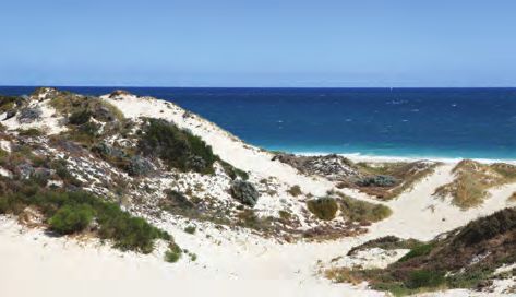
Tamala
     Conservation Park

     Summary		                                                                                                                                               1

     1.   Background                                                                                                                                         2
          1.1    Areas for inclusion......................................................................................................................... 2
          1.2    Regional conservation values......................................................................................................... 2
          1.3    Perth’s parks system...................................................................................................................... 3

     2.   Values and description of the proposed park                                                                                                        4
          2.1    Physical and biological values....................................................................................................... 4
          2.2    Cultural heritage............................................................................................................................ 6
          2.3    Recreation values.......................................................................................................................... 7

     3.   Establishment and management                                                                                                                       9
          3.1    Park management......................................................................................................................... 9
          3.2    Land vestings.............................................................................................................................. 10
          3.3    Potential future additions............................................................................................................. 10
          3.4    Community involvement.............................................................................................................. 11

     4.   Summary of issues and recommendations                                                                                                            12

     5.   References                                                                                                                                       15

     6.   Appendices                                                                                                                                       16
          Appendix 1: Membership of the Community Advisory Committee............................................................ 16
          Appendix 2: Membership of the Technical Advisory Committee............................................................... 17

          Figures
          Figure 1:       Location of the park in a regional context within the MRS.................................................... 18
          Figure 2:       Aerial photograph showing proposed park boundary........................................................... 19
          Figure 3:       Current land tenure and management................................................................................ 20
          Figure 4:       Suggested land tenure and management........................................................................... 21
          Figure 5:       Tamala Park Conservation Park Establishment Plan chronology............................................ 22

iv
Establishment Plan

Summary
This report outlines the rationale for the                 5. To provide sustainable recreational access that is
establishment of a conservation park between Burns            conducive with the protection and management
Beach and Mindarie as a Class A Reserve. It describes         of the high environmental values of the area.
its conservation and recreation values, identifies the
proposed boundaries and outlines park management           Accordingly, the Establishment Plan:
options, tenure and establishment process.                 1. Defines the area to be included within the
The proposed park comprises around 380 hectares               proposed park, including potential future additions
of high quality coastal vegetation bordered in                that is essential to achieving objective 3 noted
the west by the Indian Ocean and to the east by               above.
Marmion Avenue. The subject area is entirely reserved      2. Briefly describes the environmental and
for parks and recreation under the Metropolitan               geophysical values of the park and makes
Region Scheme (MRS). The creation of the park will            recommendations for further essential flora and
help secure the establishment of the “East-West               fauna studies.
Green Wedge” identified in the North West Corridor         3. Suggests options for tenure and associated
Structure Plan (1977 and 1992 update) and will                management responsibility of the park based
give effect to the environmental objectives of the            on environmental and recreational priorities and
Environmental Protection Authority (EPA) for the area         goals.
articulated in 1998.                                       4. Addresses issues of the interface of the proposed
The Community Advisory Committee (CAC) was                    park with the urban developments to the north
formed to develop this draft Establishment Plan and           and south and associated public access for
included representatives of the local authorities, State      recreational purposes.
government agencies, adjoining property developers         5. Acknowledges the need to identify and describe
and conservation and community interest groups. Mr            any Aboriginal heritage issues associated with the
Albert Jacob, MLA, Member for Ocean Reef, chaired             area.
the Committee. A technical advisory group was              6. Seeks public comment on the proposed
also established to provide technical advice and              arrangements for the park.
recommendations from State and local government
authorities.                                               Figure 1 shows the location of the proposed park in
                                                           a regional context. The name “Tamala Conservation
The terms of reference for the Community Advisory          Park” is not final and has been adopted by the
Committee in developing the Establishment Plan are         Community Advisory Committee for the purpose of
as set out in the following objectives:                    developing the Establishment Plan. The Committee
1. To protect the vegetation and landform that             encourages members of the public to suggest
   represents a single contiguous block of the             alternative names for the new park. Suggestions will
   physical and biological diversity of the Quindalup      be considered in the review of public comments, and
   Dune Systems.                                           the preferred choice may appear in the development
2. To protect the integrity, functionality and             of the subsequent management plan.
   environmental value of the remaining dunal
   system.
3. To create an east-west bushland corridor from
   the coast through Neerabup National Park and
   beyond to conservation reserves on the Gnangara
   Mound.
4. To give effect to the long-standing core area
   recommended for conservation and regional
   open space in System 6 recommendations,
   the North-West Corridor Structure Plan and
   Bush Forever.

                                                                                                                    1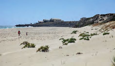
Tamala
    Conservation Park

    1. Background

    1.1                                                       of cost in order to secure the development of the
    Areas proposed for inclusion                              balance of their property for urban purposes.
    The area lies in within the cities of Wanneroo            In 2003, the Western Australian Planning
    (northern portion) and Joondalup and comprises            Commission commenced the Negotiated Planning
    around 380 hectares of high quality coastal               Solution with the Tamala Park Regional Council
    vegetation (approximately the size of King’s Park). It    (TPRC), representing seven local authorities for the
    is situated between Burns Beach and Mindarie and is       transfer of around 90 hectares owned by the Tamala
    bound on the west by the Indian Ocean and Marmion         Park Regional Council. The land was transferred to
    Avenue on the east. The entire area lies within           the Western Australian Planning Commission in
    Bush Forever site 322 and consists of around 234          2008 and forms the north and west portions of the
    hectares, owned by the Western Australian Planning        proposed park. The Negotiated Planning Solution
    Commission (WAPC) and 147 hectares of Crown               provided for the balance of Tamala Park Regional
    Reserves (refer figure 2).                                Council land to be zoned urban and urban deferred.
    In 1994, the Burns Beach Property Trust (BBPT)            There are four existing Crown reserves along the
    proposed an urban development of 260 hectares of          coast between Mindarie and Burns Beach that are
    land within the southern half that was zoned as rural     currently managed by the cities of Wanneroo and
    land. This proposal was referred to the Environmental     Joondalup for the purpose of recreation.
    Protection Authority (EPA), who conducted a Public
    environmental review.                                     Councils of both cities have formally advised the
                                                              Community Advisory Committee that they are
    The Environmental Protection Authority recommended        prepared to continue managing these reserves
    to the Minister for the Environment that development      wholly or in part, conditional upon State Government
    only be permitted in a much smaller area of               funding and maintaining a dual use path along the
    approximately 55 hectares outside of the Bush Forever     coast to connect Burns Beach and Mindarie.
    boundary. In approving urban development for the 55
    hectares, the Minister stated that future proposed use    The provision of facilities associated with the
    of the remaining 260 hectares could be dealt with via     development of a swimming beach would occur
    a Metropolitan Region Scheme amendment process,           at the northern end, on land managed by the City
    and considered by the Environmental Protection            of Wanneroo. The City has indicated its agreement
    Authority under Section 48A of the Environmental          in principle subject to further engineering and
    Protection Act.                                           environmental studies to be carried out and an
                                                              agreement on funding.
    The Metropolitan Region Scheme (Clarkson-Butler)
    amendment was advertised for public comment in
    1999 and proposed that 170 hectares be rezoned            1.2
    urban and 120 hectares be reserved for parks and          Regional conservation values
    recreation. The amendment was assessed by the
    Environmental Protection Authority which reiterated its   The environmental significance of the Mindarie dunal
    recommendation that only 55 hectares be developed.        systems and associated vegetation communities the
    To resolve the matter, the Minister for Environment       subject of this proposal has been well documented
    established a review committee. The Minister for          in a number of studies dating back nearly thirty years.
    Environment and Minister for Planning decided             Its regional importance has been recognised in a
    that 146 hectares should be rezoned for urban             range of planning initiatives, including the North West
    development and the balance become park and               Corridor Structure Plan, System 6 and Bush Forever. It
    recreation.                                               is mostly reserved for parks and recreation under the
                                                              Metropolitan Region Scheme (MRS). Its physical and
    The Western Australian Planning Commission                biological values are described in this report at 2.1.
    purchased 20 hectares from the Burns Beach Property
    Trust and they agreed to concede 124 hectares free

2
Establishment Plan

1.3                                                    Due to the high conservation values of the subject
Perth’s parks system                                   area, it is proposed that the primary management
                                                       responsibility would lie with the Conservation
In 1955 the Stephenson-Hepburn report proposed the     Commission of Western Australia and be managed
establishment of the Metropolitan Region Scheme        by the Department of Environment and Conservation
(MRS), which created a system of land use based on     (DEC). The Department of Environment and
specific zones and reservations. Land for parks and    Conservation have a number of categories of land
reserves was designated as “parks and recreation”      management, including national parks, regional
and included areas of regional conservation and        parks, nature reserves and conservation parks.
recreation significance, as well as sites of high
landscape value. Some areas of parks and recreation    National parks are reserved for the national
are included in existing national parks and similar    significance of their scenic, biological or cultural
areas such as nature reserves.                         values. Conservation parks are managed for similar
                                                       values but are of regional or local significance.
The Regional Open Space Concept in the Corridor        National parks and conservation parks are created
Plan for Perth (Metropolitan Region Planning           under the Land Administration Act 1997 and offer the
Authority 1970) and Metroplan (Department of           highest security of tenure.
Planning and Urban Development 1990) proposed
the establishment of a comprehensive system            Regional parks usually consist of various land tenures
of regional parks in the metropolitan region. The      and management involvement by various agencies
concept of regional open space was to provide the      and generally include developed recreation areas
protection of areas of regional significance through   and associated infrastructure.
the establishment of regional parks with three basic
                                                       Nature reserves are managed essentially for their
functions:
                                                       conservation values and have limited or no public
• to provide for recreation;                           access.
• to conserve the natural environment; and
                                                       During the Establishment Plan process, the
• to conserve man-made landscapes.
                                                       Department of Environment and Conservation
                                                       advised the Committee that it supported the
                                                       protection of the bushland area the subject of this
                                                       plan as an A Class reserve and considered the
                                                       area would most appropriately be managed as a
                                                       conservation park.
                                                       This recognises its high conservation values but
                                                       permits an element of suitable managed passive
                                                       recreation, such as bush walks. As a conservation
                                                       park, and an A class reserve under the Land
                                                       Administration Act 1997, it will enjoy a very high
                                                       level of tenure protection, with virtually any proposed
                                                       amendments requiring approval by the State
                                                       Parliament. The Community Advisory Committee
                                                       endorses the proposal by the Department of
                                                       Environment and Conservation to manage the area
                                                       under its responsibility as a conservation park.

                                                                                                                 3
Tamala
Conservation Park
2. Values and description
of the proposed park
2.1
Physical and biological values
In its recommendation on the Burns Beach Property
Trust proposal for urban development of the southern
area, the Environmental Protection Authority noted:
“Together with the area to the north....this area is of
exceedingly high conservation value, representing
a diverse area of coastal land near Perth, which
conserves a range of typical and unusual coastal
plants and communities. This larger area forms a
bushland link between…the coastal reserves to the
north and south…and the west...to Neerabup National
Park. Another comparable area is not available in the
Perth Metropolitan Area.” (Environmental Protection
Authority Bulletin 880, 1998, p 15)
The entire area lies within Bush Forever Area 322
(except for a very narrow coastal strip in the north and
south)1.
2.1.1 Dunal systems “Cuspate forelands along the coast are a system
of global geoheritage significance, and Burns
The proposed park contains Quindalup and Spearwood
Beach Cuspate Foreland as part of this gradation
dunes of varying age, overlaying a layer of Tamala
is part of a globally important system, in that it is
limestone. South Mindarie represents the most well
the most southerly and best developed example
defined remaining cuspate foreland and its associated
of its ‘stage of development’.”
range of medium to small scale dune landforms
and vegetation habitats in this coastal sector (V & C
Semeniuk Research Group, 1991).
Large blowouts extend over a significant portion
The site contains the only example of Quindalup dunes of the mid-coastal section of the proposed park.
within the Perth metropolitan area that meets all six Although these are a natural feature of the coastline,
conservation criteria for such sites specified in table 3 human intervention, especially in the form of off-
of the Environmental Protection Authority Bulletin 880, road vehicle activity, prevents natural and assisted
1998. revegetation and can result in environmentally
undesirable expansion of the blowouts.
Professor Semeniuk, an authority on coastal
geomorphology, made a presentation to the Much of the fore-dunes, particularly to the north,
Community Advisory Committee on the globally unique and those bordering the blowouts on either side, are
geo-heritage values of the coastline of South-Western steep and well vegetated. The exception is the various
Australia and the subject area in particular. off road vehicle trails that transect the area.
There is also a significant east-west dune ridge just
1 Bush Forever is a State Government policy that seeks to protect at
least 10 per-cent of each of the original 26 vegetation complexes north of the Burns Beach development that is part
in the metropolitan region of the Swan Coastal Plain. The underlying of a major parabolic dune formation that crosses
policy document is the Western Australian Planning Commission State
Planning Policy 2.8, Bushland Policy for the Perth Metropolitan Region.
Marmion Avenue. They include the fore-dunes and
Environmental Protection Authority approval is required for the clearing have geophysical and cultural heritage importance.
of any native vegetation under the Environmental Protection (Clearing
of Native Vegetation) Regulations 2004).
4Establishment Plan
2.1.2 Vegetation communities The Tamala Park Regional Council commissioned
Syrinx Environmental Pty Ltd (May 2009) to undertake
Two vegetation complexes have been mapped within
a search for Declared Rare (DRF) and Priority Flora
the park (Heddle et al, 1980). These are:
on the land on the western side of Marmion Avenue,
1. The Quindalup Complex of the Quindalup ceded by them to the Western Australian Planning
dunes coastal complex consisting mainly of two Commission, with the results made available to the
alliances — the strand and fore-dune alliance Community Advisory Council.
and the mobile and stable-dune alliance. Local
Overall, the Syrinx report noted that the vegetation
variations include the low closed forest of
condition in the area surveyed was variable and
Melaleuca Lanceolata – Callitris Preissii and the
dependent on the width of the bushland, soil type
closed shrub of Acacia rostellifera (Heddle et
and vegetation covering the area. Bushland that
al 1980, per Environmental Protection Authority
was found to be in excellent condition was limited
Bulletin 880 1998).
to small pockets in the centre and dense thickets
2. The Cottesloe Complex of the Spearwood dunes of Banksia sessilis. The report noted however that
– Central and South: Mosaic of Woodland Tuart the general bushland condition had deteriorated
and open forest of Tuart-Jarrah-Marri closed heath significantly since the Mattiske survey of 2000.
on the limestone outcrops (Heddle et al 1980, op
cit). The Banksia woodlands associated with this A variety of weeds were recorded, the most prolific
complex are of high conservation value, given the being Geraldton Carnation weed (Euphorbia
relative scarcity of Cottesloe Complex Banksia terracina). Species such as Rose geranium
woodlands close to the coast within this region (Pelargonium capitatum), veldt grass (Ehrharta
(Trudgen 1990). The vegetation communities calycina) and garden weeds such as yucca plants
represented on the Spearwood sands are and agave were also recorded bordering vehicle
generally species rich and provide good fauna tracks where rubbish dumping had occurred.
habitat.
No declared rare flora were found but the Priority 2
A series of significant species have been recorded, species of moss Fabronia hampeana was found
including four listed as “priority 3 taxa”2. These are growing on nine different Zamia palms (Macrozamia
Jacksonia sericea, Conostylis pauciflora subsp. riedlei).
euryrhipis, Hibbertia spicata subsp leptotheca and
Stylidium maritima. A species of particular interest is
2.1.3 Terrestrial fauna
Sonchus megalocarpa, a native thistle that occurs on
the ridgelines of large blowouts and is the first record The park will form part of an important wildlife refuge
on the mainland in the Perth to Bunbury region. and corridor linkage from the coast to Neerabup
(Keighery, 1991) National Park and beyond to the State forest areas on
the Gnangara Mound. According to the Environmental
Over 70 per-cent of the vegetation has been Protection Authority Bulletin 880. The proposed park
assessed as excellent to pristine condition by Bush contains:
Forever 2000. 168 native taxa have been identified in
the park (Keighery, 1991).
“a vegetated transition between the Quindalup
and Spearwood dunes that provides particularly
important feeding habitat for a range of fauna
due to seasonal diversity of flowering times,
necessary to sustain populations of resident
2 Under the Wildlife Conservation Act, the Minister for the Environment nectivorous pollinators.
may declare species of protected flora to be rare flora if they are
considered to be in danger of extinction, rare or otherwise in need of In zoogeographic terms, the Quindalup/
special protection. Such species are referred to as threatened flora, Spearwood dune system has a richer bird and
and receive special management attention.
reptile fauna than other dune systems on the
Priority 3 - poorly known: taxa which are known from several
populations, at least some of which are not believed to be under Swan Coastal Plain.”
immediate threat (i.e. not currently endangered). Such taxa are
under consideration for declaration as ‘rare flora’, but are in need of
further survey.
5Tamala
Conservation Park
The natural distribution of birds such as the 2.2
Variegated and White-winged fairy-wrens is restricted Cultural heritage
to the Quindalup/Spearwood dune system (J Dell,
personal communication, Environmental Protection The name Mindarie is a Nyoongar word meaning
Authority Bulletin 971, March 2000). either “ceremonial place” or “green water” and was
originally applied to Lake Mindarie, further inland,
A limited survey has identified 54 bird species in the which was first reported by Alexander Forrest in 1874.
area, three native mammal species, and 23 different The Mooro group of Nyoongar people (one of four
types of reptiles (Kinhill Stearns 1983). groups of the Whadjuk peoples who populated the
Perth bioregion of the Swan Coastal Plain), led by
During the Syrinx survey referred to above, evidence
Yellagonga, were said to be familiar with the area and
of feral animals such as rabbits and foxes were
local land features are referred to in their stories and
discovered. Kangaroos have been sighted as recently
legends. Waukolup Hill (“place of the Waugul”) is a
as 2010. The Western Brush Wallaby was recorded
landmark feature of the dunal system in this location
within the site some years ago and the bushland
visible from a considerable distance inland and is
has been identified by the Environmental Protection
connected with the creation serpent, the Waugul.
Authority as potential habitat for the Honey Possum
(Noolbenger). After European settlement, the area was very lightly
populated until the 1980s, when Mindarie Keys
The same survey also noted a flock of around 350
was proposed and the Tamala Park refuse site was
Carnaby Cockatoos feeding on Banksia sessilis to
announced. The first residents moved in to Mindarie
the south of the site. These Cockatoos are listed as a
Keys in 1987 with the remainder of the suburb being
threatened species both at a State and National level
developed in the early 2000s. Mindarie is situated in
and use coastal plain vegetation such as present at
the City of Wanneroo.
this site for foraging and roosting.
The land at Burns Beach was originally owned by
Much of the study area contains plant species such
the Midland Railway Company which had been
as Melaleuca systena and Lomandra maritima,
given large land grants along much of its track from
the latter being identified habitat species for the
Midland to Walkaway that extended all the way
graceful sun moth (Synemon gratiosa). Officers of to the coast. In 1908 the Wanneroo Roads Board
the Department of Environment and Conservation successfully applied for a 20 hectare reserve for
reported sightings of the moth at this location in early camping and a health resort.
20103.
By the 1920s, the area was well used by locals and
The Community Advisory Committee recommends was referred to as “Burns’ Beach” after a farmer who
that funding for comprehensive weed mapping and ran sheep in the area. It was mainly accessed by boat
flora and fauna surveys be provided as a matter of or a rough dirt track.
priority for interim management of the area.
For many years tourism and fishing were the
main occupations and it was not until after the
3 The graceful sun moth is a small day-flying moth found only on Second World War that it was connected by road to
the Swan Coastal Plain and is specially protected fauna under
the WA Wildlife Conservation Act 1950, as it is rare or likely to Wanneroo Road. Perth’s rapidly expanding urban
become extinct. It is listed as endangered under the Commonwealth growth reached the area in the early1990s and the
Environment Protection and Biodiversity Conservation Act 1999
(EPBC Act). Prior to the commencement of the graceful sun moth
suburb is now located in the City of Joondalup.
project in 2009, there were few known populations between Quinns
Rocks and Mandurah, none of which were in formal State-managed There is a caravan park, popular seaside cafe and
conservation areas, and almost all known populations were on restaurant adjacent to the carpark at the end of
small isolated bushland remnants. The first year of survey was very Ocean parade and infrastructure supporting a small
successful with new populations located as far north as Leeman.
Several of these populations are within conservation reserves local beach.
providing valuable protection for this species, although other new
populations were found in areas of habitat that are proposed for
clearing. The Department of Environment and Conservation (DEC)
will continue to survey the graceful sun moth and its habitat. This
survey will seek to further clarify the distribution of the graceful
sun moth in existing and proposed conservation reserves, and will
provide information on how much threat continued clearing on the
Swan Coastal Plain poses to the species’ conservation.
6Establishment Plan
2.3 lifesaving facility. A location has been identified by a
Recreation values Department of Planning coastal engineering study4
at the northern end of the proposed park (locally
In 1992, the City of Wanneroo and the then referred to as Clayton’s and Rambo’s Beaches, shown
Department of Planning and Urban Development below).
(DPUD) commissioned the Coastal Planning Study
– Burns Beach to Jindalee Report (Hames Sharley
Australia, 1992). The stated goal of the study was
“…to achieve a balance between the protection
of environmental quality and provision for the
recreational needs of the people who will use the
area.”
The Coastal Planning Study identified four key
strategic objectives:
• to safeguard the natural resources of the area
from excessive use;
• to facilitate public access to the beach in a
sustainable manner;
• to provide facilities that will enhance the
recreational values of the coast; and
• to monitor the condition of the coastal reserve
and to manage it accordingly.
The coastline of the proposed park includes a variety
of beach forms ranging from rocky headlands to
clean sandy beaches. The latter have been identified
as being generally safe for coastal recreation. Many
These extend approximately two kilometres south
members of the local and regional community
along the coast from Alexandria View. The remainder
have expressed a desire over a number of years
of the coast south of here is considered unsuitable
for recreational access to the area, including the
for swimming as it is heavily perched, although some
beaches and bushland.
locals swim at the Burns Beach end, where there is
The Burns Beach Property Trust is developing a small swimming area with car park and change
beachside recreational access along a 1.2 kilometre rooms. This beach is only able to accommodate local
stretch of coast in the south west corner of the users.
reserve under a Foreshore Management Plan, as a
The Burns Beach plan includes a shared path for
condition of the development of the adjoining urban
walking and cycling, which offers the potential for
area. This area, which will connect with the existing
extension north towards Mindarie. There is strong
beachfront infrastructure further south, would be
local community expectation for such a path.
expected to be transferred to the management of
the City of Joondalup (provisionally two years after In early 2008, The City of Wanneroo received two
the completion of works), and forms part of the main petitions requesting Council’s consideration of the
reserve. The Burns Beach Foreshore Management construction of a shared path and the development
Plan states:“The FMP has been prepared in a manner of a management plan to protect the environmental
so as to integrate sustainable community use of the values of the area. Similarly, the City of Joondalup
coastal area with the conservation of the coastline received a petition of over 2500 signatures making
and associated natural features” (Cardno BSD, 2004). the same request. There has been increasing demand
for the shared path as the area experiences an
The Foreshore Management Plan does not include
increase in population.
a suitable recreational swimming beach. However,
the concept plan indicated an access road further
north to the beach with a possible associated surf 4 Department for Planning and Infrastructure, Technical Report No 475,
October 2008
7Tamala
Conservation Park
In July 2008, the Wanneroo Council resolved to funding approval for any capital works as part of
approach the State Government to amalgamate all the development of its management plan for the
of the parks and recreation parcels of land between proposed park and for ongoing management.
Mindarie and Burns Beach for the creation of a
regional park, incorporating a shared pathway. The Any clearing of vegetation would have to meet
Wanneroo Council also sought the support of the City the requirements of the Environmental Protection
of Joondalup, whose Council resolved to support this (Clearing of Native Vegetation) Regulations 2004
request in November 2008. and approvals under the Aboriginal Heritage Act
1972. With confirmation of the presence of the
In December 2008, the City of Wanneroo wrote Graceful Sun Moth, any development proposals
to the Minister for Planning with the request. The would also have to comply with the requirements
Minister advised the council that the Western of the Commonwealth Environment Protection and
Australian Planning Commission had established Biodiversity Conservation Act 1999.
a Community Advisory Committee, with nominated
representatives from both the City of Joondalup and Accordingly, the Community Advisory Committee
City of Wanneroo. He also stated that this was for the recommends as a matter of priority that the City of
purpose of producing an establishment plan to guide Wanneroo, the City of Joondalup and the Western
the long-term management of the area and that the Australian Planning Commission consider joint
provision of a shared path would form part of the funding for the appropriate studies to be undertaken
Committee’s considerations. The Committee first met to determine the optimal alignment and cost of a
on the 20 January 2009. shared path from Burns Beach to Mindarie. At least
two options should be outlined, one of which is that
The matter of the shared path was addressed early the alignment be as close to the coast as possible;
in the Community Advisory Council’s deliberations, and an alternative route(s) that may be lower in cost
particularly in regard to alignment, with a strong but still close to the foreshore reserve.
feeling that the preferred route should be as close to
the coast as possible. The matter was referred to the It is also essential that public access to the coast is
Technical Advisory Group (TAG) constituted to provide managed in a way that protects the environmental
specialist advice to the Community Advisory Council. values of the proposed park. An issue already
identified is the uncontrolled access of off-road
Taking into account the high environmental values vehicles, which is having an increasingly detrimental
of the fore-dunes, the dynamic nature of the effect on the area.
coastline, particularly at the blowouts, and the steeply
undulating topography, the Technical Advisory Group The Community Advisory Committee has identified
considered that the construction of a path through perimeter security as a priority management
the near coastal area could be prohibitively expensive requirement.
and have adverse environmental impacts. There were
also concerns regarding the relative isolation of such
a path for the personal safety of users, particularly in
the event of a fire.
Due to the regional nature of the shared path
facility, both city councils have advised the
Community Advisory Committee that their continued
management of the foreshore reserves is partly
conditional. This includes any shared path not
being built on land they manage and on funding
being provided by the Western Australian Planning
Commission or the State Government. This would
require the path to be built through the conservation
park, proposed to be managed by the Department
of Environment and Conservation, who would have
to accept responsibility for its management and
maintenance. The Department would have to obtain
8Establishment Plan
3. Establishment and
management
3.1
Park management
The park may be described as having three broad
zones of usage:
• conservation and protection
• natural environment uses
• recreational uses.
Conservation and protection constitute the majority
area of the park, recognising the high environmental
and landscape values it contains. The primary
management objective here is to avoid further
disturbance to the bushland, so public access is
either excluded or limited to dedicated walk trails.
Given conservation and protection comprises the
majority of the proposed park, the Community
Advisory Council believes that the Department of
Environment and Conservation should be the end
manager of this area. a part of the dynamics of the coast, regular vehicle
access severely impedes any naturally occurring
Natural environment uses refers to those sections revegetation. Some of the existing tracks might be
of the park that consist of bushland with some level retained and utilised as management tracks for
of developed amenity and public access, such as various purposes, such as fire management, but
sealed paths for access to recreational facilities or for public vehicular access (other than outlined above)
use by walkers and cyclists. Such access is controlled must be excluded.
through the use of fencing and other measures.
These areas are usually (but not exclusively) The Community Advisory Committee endorsed the
managed by the Department of Environment and provision of a hard-stand interface with the proposed
Conservation. park by means of roads on the boundaries of the
northern and southern residential developments. Both
Recreation areas are identified and set aside of these interfaces will be accompanied by measures
specifically for public use, such as swimming and (fencing and/or grade separation) to prevent vehicle
fishing beaches, and associated infrastructure. access other than that deemed necessary for
Decisions still have to be made regarding the management purposes or controlled access to the
development of facilities and infrastructure for a beaches.
larger swimming beach. Such matters would need to
be addressed and agreed upon in the development Pedestrian access will be similarly managed at
of a management plan for the greater park area. The appropriate locations under agreement between the
Community Advisory Committee recommends that developers and the relevant land manager.
any swimming beaches, their access and associated
The Community Advisory Committee recommends
infrastructure should be managed by the relevant
some form of fenced hard-stand public road access
local government authorities.
from Long Beach Promenade through the reserve
Until recently, vehicle access to the area has been to the beach, and that this should be given further
poorly managed. As a result, the area is crossed detailed investigation. There should be no vehicular
by numerous tracks and paths, created mainly by access beyond the hard-stand onto the beach, other
various kinds of off road vehicles. Although the than for management purposes.
blowouts in the coastal centre of the reservation are
9Tamala
Conservation Park
3.2 City of Wanneroo, dependent on decisions by Council
Land vestings regarding responsibility for the swimming beach
access and associated infrastructure.
The area proposed for management by the
Department of Environment and Conservation would The Tamala Park Regional Council has expressed
be transferred to State ownership and a management a strong interest in road access from the western
order under the Land Administration Act 1997 issued boundary of its proposed subdivision along Long
to the Conservation Commission of Western Australia Beach Promenade to the beach to the west. At a
for management by the Department of Environment minimum, this would require suitable car parking
and Conservation. and other infrastructure associated with a swimming
beach.
The Cities of Wanneroo and Joondalup currently
manage all of the foreshore areas as “C” class The Department of Environment and Conservation
reserves for recreation (refer Figure 3). They have has advised the Community Advisory Committee
indicated their agreement to continue management that any such access and infrastructure would not
of coastal sections of the park, with amended be provided by nor managed by them as a priority
boundaries, subject to the conditions referred to management objective and that these facilities
earlier in respect of the proposed shared path. should be managed by the City of Wanneroo.
In the City of Joondalup, the management order As stated earlier, the Community Advisory Committee
of Reserve 38526 would be given up for inclusion strongly supports the provision of controlled vehicle
in the conservation area for management by the access to the beach, particularly at the Mindarie
Department of Environment and Conservation. end, and recommends that discussions to facilitate
In the City of Wanneroo, the boundaries of both this should occur between the City of Wanneroo,
reserves would be reviewed, with the Department Tamala Park Regional Council and the Department of
of Environment and Conservation managing the Environment and Conservation.
majority of Reserve 35890. Management of the
northern portion of this reserve may remain with the
3.3
Potential future additions
The System 6 Report and the Environmental
Protection Authority (Public Environmental Review,
MRS Amendment 992/33, Environmental Protection
Authority Bulletin 880 Bulletin 880 of 1998) both
refer to the importance of the “green wedges” or
environmental linkages of the coastal area east
to Neerabup National Park and the State Forests.
These include corridors of parks and recreation
reservation north and south of the Mindarie Regional
Council waste management facility and east through
Neerabup National Park. It would be appropriate if
these areas were all managed in the longer term by
the Department of Environment and Conservation.
They could be managed either as part of Neerabup
National Park or as an addition to the coastal reserve.
In any event, the Community Advisory Committee
recommends that a planning study be undertaken
as part of the development of the Department of
Environment and Conservation’s Management Plan
to consider issues and identify action to maintain and
enhance the east-west ecological and open space
link from the coast through Tamala Park to Neerabup
National Park.
10Establishment Plan
3.4
Community involvement
There has been a long history of involvement and
commitment by community based groups in planning
for the use and management of the area that is the
subject of this plan. This community involvement
is reflected in the membership of the Community
Advisory Committee, whose representatives have
made substantial contributions to the plan’s
development.
As part of its Burns Beach subdivision, the Burns
Beach Property Trust and its Manager, Peet Ltd, is
implementing a Foreshore Management Plan that
has involved rehabilitation of fore-dune vegetation,
provision of managed access to the beach at various
locations from a shared path and associated public
infrastructure, including parking and barbecue areas.
The Community Advisory Committee commends
the Burns Beach Property Trust/Peet Ltd on its
contribution to managed community access to the
beach at the southern end of the proposed park.
Continuing community participation will be
encouraged through the opportunity to comment on
this report and further Department of Environment
and Conservation consultation with the community
as part of the development of its management
plan for the area. Additionally, the Department
of Environment and Conservation has ongoing
engagement with “Friends of” groups in the
operational management of its various parks and
reserves.
11Tamala
Conservation Park
4. Summary of issues and
recommendations
Land vesting arrangements/shared path Management tenure
Both the City of Wanneroo and the City of Joondalup The Department of Environment and Conservation
have made continued management of foreshore has stated that it will manage the area vested to the
areas contingent upon the Western Australian Conservation Commission of Western Australia as a
Planning Commission or the State Government conservation park. This will provide a very high level
funding and managing the proposed shared path. of protection.
The Commission can only contribute to funding for
such projects on land that it owns or manages.
Current identifiable sources of State Government Recommendation:
funding would be through the Department of The Community Advisory Committee endorses
Environment and Conservation in the development the proposal by the Department of Environment
of the management plan and subject to approval and Conservation to manage the area to be
through the Consolidated Account Budget Process, or under its responsibility as a conservation park.
the Bikewest Unit within the Department of Transport.
Any part of the subject area not managed by either
the City of Wanneroo or the City of Joondalup, will
be managed by the Department of Environment and
Conservation primarily for conservation purposes. Given the increased demand from the community
for access to safe swimming areas adjacent to
Mindarie and the future Tamala Park project, the
Committee has considered that planning should be
Recommendation: undertaken by the local government to identify a
That as a matter of priority, the City of public recreational swimming area off Long Beach
Wanneroo, the City of Joondalup and the Promenade. This area should include a hard-stand
Western Australian Planning Commission access road, public parking toilets and potential surf
consider jointly funding appropriate studies for lifesaving facilities.
a shared path from Burns Beach to Mindarie.
Recommendation:
That a fenced hard-stand public road access,
with appropriately located facilities such as car
parking, toilets and potential surf-life-saving
facilities, be the subject of further investigation.
There should be no vehicular access beyond
the hard-stand area other than for management
purposes.
12Establishment Plan
Conservation and heritage values Unauthorised vehicle access
The area has very high environmental and A matter of some concern has been the intrusion
geophysical values that require appropriate of vehicles in to the area, with associated rubbish
protection and management. dumping, the spreading of weeds and damage to
vegetation.
Recommendation:
That funding for comprehensive weed mapping Recommendation:
and flora and fauna surveys be provided as a That the perimeter of the proposed park be
matter of priority for interim management of the appropriately secured to minimise/prevent
area. unauthorised vehicle access to the area.
The Community Advisory Committee acknowledges
the importance of the ecological linkages of the
proposed park with other conservation areas further Naming the park
inland.
Tamala Conservation Park is an interim name
adopted by the Committee for the development of the
Establishment Plan.
Recommendation:
That a planning study be undertaken as part
of the development of the Department of Recommendation:
Environment and Conservation’s Management
Plan to consider issues and identify action to That members of the public be invited to
maintain and enhance the east-west ecological submit suggestions for naming the park to the
and open space link from the coast through Community Advisory Committee as a part of the
Tamala Park to Neerabup National Park. public comment process.
Aboriginal heritage Recommendations arising from public
comments.
An ethnographic and archeological survey of the area
has been commissioned by the Western Australian A total of 14 submissions were received during the
Planning Commission and certain recommendations public comment period from a variety of agencies,
have been made. organisations and individuals.
All of the submissions were supportive of the
recommendations for the Park or had no objections.
Recommendation:
The Committee identified four key areas of comment
That the findings and recommendations of for formal inclusion in the Establishment Plan, as
the Aboriginal Heritage Survey of the subject follows:
area commissioned by the Western Australian
1. The Department of Environment and Conservation
Planning Commission be incorporated into
(DEC) must receive sufficient recurrent funding
the Management Plan to be prepared by the
to ensure an appropriate level of ongoing
Department of Environment and Conservation.
management of the high conservation values of
the proposed park.
13Tamala
Conservation Park
2. Appropriate infrastructure must be provided
across/under major north/south transport
corridors to provide effective east/west wildlife
corridors and connectivity from the coast to the
hinterland.
3. Management of the coastal section of the park
be a matter of further discussion between DEC
and the local government authorities to avoid the
creation of narrow difficult to manage strips as
shown on Figure 4, particularly at the Joondalup
end. Consideration should be given to DEC
managing all of the coast north of the Burns
Beach subdivision, except the area in the north
proposed for a recreational swimming beach.
4. The Park should be established as a matter of
priority.
Naming
None of the submissions suggested a name for the
Park. In the ethnographic report commissioned by
the WAPC, reference was made to Noongar people
identifying three distinct cultural divisions on the
Swan Coastal Plain. The coastal area was apparently
referred to as Booyeembara, deriving from the
Noongar word for rock (boya or booyee), referring to
the prevalence of limestone in the area.
The Committee has recommended that this name
be considered by DEC when developing the
Management Plan for the Park.
14Establishment Plan
5. References Keighery, G.J. (1992). Coastal Limestone Endemics.
Unpublished report for the Department of
Conservation and Land Management.
Note: The majority of these references are quoted in
the text as extracts from the EPA Public Environmental Semeniuk, V., Cresswell, I.D. and Wurm, P.A. (1989).
Review Report 19. The Quindalup Dunes: the regional system, physical
framework and vegetation habitats. Journal of the
Department of Conservation and Environment Royal Society of Western Australia. Vol 71 Pt 2&3
(1983). Conservation Reserves for Western Australia. p23-47.
The Darling System - System 6. Parts 1&2. Report 13.
Trudgen, M.E. (1990). A report on the flora
Gibson, N., Keighery, B.J., Keighery, G.J., Burbidge, and vegetation of an area at Burns Beach and
A.H. and Lyons, M.N. (1994). A Floristic Survey of the conservation issues affecting it. Unpublished report,
Southern Swan Coastal Plain. Unpublished report Halpern Glick Maunsell, Perth WA.
for the Australian Heritage Commission prepared by
Department of Conservation and Land Management Trudgen, M. (1996). An assessment of the
and the Conservation Council of Western Australia conservation values of the remnant vegetation in
(Inc.). the City of Wanneroo with recommendations for
appropriate reserves for the City. An unpublished
Griffin, E.A. (1993). Flora of the Quindalup Dunes report for the City of Wanneroo.
between the Swan and Irwin Rivers, Western Australia.
Unpublished report to the Coastal Planning Branch, V&C Semeniuk Research Group (1992).
Department of Planning and Urban Development and Environmental and landscape audit of the
the Heritage Council of Western Australia. southwest, northwest and northeast corridors of
Perth metropolitan area. Stage 1 Interim report: The
Griffin, E.A. and Trudgen, M. (1994). Variation in Northeast corridor study. An unpublished report for
the floristic composition of the vegetation growing Department of Planning and Urban Development
on the Holocene dunes between Whitfords and (available for viewing at Ministry for Planning Library).
Lancelin, south-western Western Australia, and
recommendations to conserve that variation.
Unpublished report, Peet and Company, Perth.
Heddle, E.M., Loneragan, O.W. and Havel, J.J. (1980).
Vegetation Complexes of the Darling System Western
Australia. IN Atlas of Natural Resources Darling
System of WA. Department of Conservation and
Environment. UWA Press. Perth.
How, R.A., Harvey, M.S., Dell, J., and Waldock, J.M.
(1996). Ground fauna of the urban bushland
remnants in Perth. Report to the Australian Heritage
Commission. NEP Grant N 93/04.
Keighery, G.J., (1991). Flora and Vegetation of the
Mindarie Cusp Area. An unpublished report to the
Department of Conservation and Land Management
for the Department of Planning and Urban
Development.
15Tamala
Conservation Park
6. Appendices
Appendix 1: Membership of the Community Advisory Committee
Name Organisation
Mr Albert Jacob MLA (Chair) Member for Ocean Reef
Mr Ross Parker Western Australian Planning Commission (WAPC)
Ms Jacqui Maguire Department of Environment & Conservation (DEC)
Mr Daniel Garlett South West Aboriginal Land and Sea Council (SWALSC)
Mr Tony Arias Tamala Park Regional Council
(Succeeded Mr Rod Constantine)
Mr Ian Barker City of Wanneroo
(Succeeded Ms Colleen Murphy)
Ms Tracey Roberts Councillor, City of Wanneroo
Mr Nelson Hinchcliff Peet Limited
Mr Jamie Parry City of Joondalup
(Succeeded Ms Glenda Blake)
Cr Kerry Hollywood Councillor, City of Joondalup
Mr Mike Norman Chair, Joondalup Community Coast Care Forum
Mr David Wake Quinns Rock Environment Group
Mr Hugh Reason Community representative
Ms Judy Gudsell Burns Beach Resident’s Association
16Establishment Plan
Appendix 2: Membership of the Technical Advisory Committee
Name Organisation
City of Joondalup
Mr Martyn Glover Director Infrastructure Services
Mr Tony Pyke Assett Management
Mr Mark Tucek Environmental Co-ordinator
Mr Keith Armstrong Conservation Co-ordinator
City of Wanneroo
Ms Colleen Murphy Co-ordinator Environmental Planning
Mr Chris Round Co-ordinator Conservation Maintenance
Department of Planning
Mr David Carter Senior Planner
Mr Ross Duckham Senior Project Planner
Department of Environment and Conservation
Ms Jacqui Maguire Senior Land Use Planner
Perth Region NRM
Ms Kate Sputore North Metro Coastcare Officer
Western Australian Planning Commission
Mr Ross Parker Policy and Project Officer
17Tamala Conservation Park
Mindarie Clarkson Figure 1:
Banksia Grove
Clayton’s Beach Carramar
Rambols Beach Tamala Park City of Wanneroo
Mariginiup
Burns Beach
Indian Kinross Tapping
Ocean
Burns Beach
Ashby
N
Currambine
Iluka
0 500 1000 1500
Joondalup
metres
Produced by:
Mapping & GeoSpatial Data Branch Sinagra
Location of the park in a regional context within the MRS
Department of Planning, WA
On behalf of:
Western Australian Planning Commission
Copyright © April 2011
ntw-map11\ \pol\urb\gro_man\Tamala Connolly
Conservation Park\A4\Figure1.dgn
Base information supplied by:
Western Australian Land Information Authority
LI 430-2009-4
2010 aerial imagery supplied by: Wanneroo
Westrn Australian Land Information Authority
(Scale 1:16000, positional accuraccy +/-10cm)
Ocean Reef
City of Joondalup
Legend
suburb boundary Heathridge
Edgewater
local government
boundary
Hocking
study boundary
Beldon
Establishment Plan
Regional context - aerial image Figure 1
18Tamala
Conservation Park
Figure 2:
Tamala Conservation Park
Aerial photograph showing proposed park boundary
NEER
ABUP
ROAD
Clarkson
Mindarie
City of Wanneroo
MA R
Clayton’s Beach
MIO
N
Indian
Rambols Beach
Tamala Park
AVE
NUE
Ocean
Kinross
N
0 100 200 300 400
metres
Produced by:
Mapping & GeoSpatial Data Branch
Department of Planning, WA
On behalf of:
Western Australian Planning Commission
Copyright © April 2011
ntw-map11\ \pol\urb\gro_man\Tamala
Conservation Park\A4\Figure2.dgn Burns Beach
Base information supplied by:
Western Australian Land Information Authority
LI 430-2009-4
2010 aerial imagery supplied by:
Westrn Australian Land Information Authority
(Scale 1:16000, positional accuraccy +/-10cm)
Legend
cadastre City of Joondalup
suburb boundary
ROAD
local government H
BEAC
boundary
S
RN
study boundary Burns Beach BU
Iluka
Aerial image Figure 2
19You can also read