Greater Blue Mountains Area State of Conservation update - April 2020 - UNESCO World Heritage Centre
←
→
Page content transcription
If your browser does not render page correctly, please read the page content below
Greater Blue Mountains Area State of Conservation update - April 2020
State of Conservation – Greater Blue Mountains Area – April 2020

Contents
Introduction .................................................................................................................................................. 3
Outstanding Universal Value ........................................................................................................................ 6
Impact of the 2019-20 fires .......................................................................................................................... 6
Direct fire impacts......................................................................................................................................... 6
Species affected ............................................................................................................................................ 7
           Flora species...................................................................................................................................... 7
           Wollemi Pine (Wollemia nobilis) ....................................................................................................... 8
           Fauna species .................................................................................................................................... 9
           Threatened ecological communities ............................................................................................... 10
Intersection with other conservation issues............................................................................................... 11
           Aboriginal cultural heritage ............................................................................................................ 11
           Weeds and feral animals................................................................................................................. 11
           Pathogens ....................................................................................................................................... 12
           Proposed raising of Warragamba Dam ........................................................................................... 12
           Coal mining in areas adjacent to the property ............................................................................... 13
Next steps ................................................................................................................................................... 13
Immediate responses.................................................................................................................................. 13
Longer term recovery ................................................................................................................................. 14
Future fire management ............................................................................................................................. 14
           Building resilience ........................................................................................................................... 15
Future of the Greater Blue Mountains Area under climate change ........................................................... 16
Appendix A: Greater Blue Mountains Area - Statement of Outstanding Universal Value ......................... 17

                                                                               2
State of Conservation – Greater Blue Mountains Area – April 2020
Introduction
The Greater Blue Mountains Area is located in the State of New South Wales (NSW). This World Heritage
property, comprising eight protected areas, consists of 1,032,6491 hectares of sandstone plateau,
escarpments and gorges dominated by temperate eucalypt forest.
This property provides a significant representation of Australia's biodiversity with ten percent of the
vascular flora as well as significant numbers of rare or threatened species, including endemic and
evolutionary relict species. For millions of years, fire and climate change have been major driving forces in
the evolution of the distinctive and diverse flora and fauna of the Greater Blue Mountains Area. The
terrain, vegetation and climate make it one of the most fire-prone regions in the world. Fire plays an
important role in the landscape as many native plant species need fire for some aspect of their life cycle or
ecology. Fires can have positive as well as negative impacts on the Greater Blue Mountains landscape,
depending on fire frequency and intensity.2
In the Australian spring and summer of 2019-20, extensive areas of southern and eastern Australia were
affected by bushfire at a scale unprecedented in recorded history. In the Greater Blue Mountains World
Heritage Area, approximately 853,977 hectares were burnt to varying extents. A prolonged period of
drought over the last few years contributed significantly to creating ecological conditions favorable to the
spread of the bushfires.
On 22 January 2020, the Australian Government wrote to the World Heritage Centre to provide an update
on the bushfire situation in Australia. Following this advice, on 28 January 2020, the World Heritage
Centre requested an update on the state of conservation of the Greater Blue Mountains Area for
consideration by the World Heritage Committee at its 44th Session. This report addresses that request.
The Australian Government is working closely with the NSW State Government, land managers, scientific
experts, other stakeholders and Aboriginal communities to better understand the impact of the 2019-20
bushfires on the Outstanding Universal Value (OUV) of the Greater Blue Mountains Area.
There is good and expanding information about the extent of areas impacted, but more work is being
undertaken to better understand the severity of these fires and the vulnerability of the species and
ecological communities in their path.
1
Plan “The GBMA boundary is the protected areas under the National Parks and Wildlife Act 1974 in the State of
New South Wales as at the date of the gazettal notice (Commonwealth of Australia Gazette No. GN 3, 24 January
2001, page 260), not the size of reserves at the time of nomination (1998) as previously published (1,032,649 ha).
2
Hammill K and Tasker L (2010), Vegetation, Fire and Climate Change in the Greater Blue Mountains World Heritage
Area, Department of Environment, Climate Change and Water.
3State of Conservation – Greater Blue Mountains Area – April 2020
Figure 1. Areas of Greater Blue Mountains World Heritage Area impacted by bushfires in 2019-20.
4State of Conservation – Greater Blue Mountains Area – April 2020
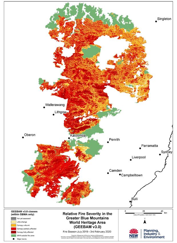
Figure 2: Relative fire severity across the Greater Blue Mountains Area in 2019-20
5State of Conservation – Greater Blue Mountains Area – April 2020
Outstanding Universal Value
The Greater Blue Mountains Area was inscribed on the World Heritage List under criteria (ix) and (x). The
Statement of Outstanding Universal Value for the property is at Appendix A. Key attributes include:
- outstanding and representative examples in a relatively small area of the evolution and
adaptation of the genus Eucalyptus and eucalypt-dominated vegetation on the Australian
continent. The Wollemi pine (Wollemia nobilis) and Blue Mountains pine (Pherosphaera
fitzgeraldii) are outstanding examples of ancient, relict species with Gondwanan affinities
(criterion ix).
- outstanding diversity of habitats and plant communities that support its globally significant
species and ecosystem diversity. A significant proportion of the Australian continent’s biodiversity
occur in the area (criterion x) including mammals, reptiles, frogs and birds.
Impact of the 2019-20 fires
Following an extended period of drought, the first of a series of bushfires in the Greater Blue Mountains
Area started as a result of lightning strike on 26 October 2019. Fires continued to burn in the Greater Blue
Mountains Area until early February 2020. During this time, approximately 853,977 hectares (or 82%) of
this World Heritage property was burnt out of a total area of 1,043,826 hectares. There was a mosaic of
fire intensity across the property, with some areas showing little change, while other areas showed
significant effects. The extent of impacts across the property using burnt area class is detailed in Table 1
below.
Torrential rain in mid-February 2020 caused flash flooding across the Greater Blue Mountains Area. These
heavy rainfall and storm events resulted in increased sediment, debris and ash runoff and erosion of some
watercourses and unsealed access routes across the property.
Further detailed investigations of the direct and indirect impacts of the bushfire events are underway.
Direct fire impacts
Assessment of biodiversity impacts associated with the different burn intensity classes is underway and
will continue over the next 6 to 12 months. Fire Extent and Severity Mapping is being undertaken for the
Greater Blue Mountains Area and more broadly across NSW.
The Old Great North Road component of the Australian Convict Sites World Heritage property is adjacent
to the Greater Blue Mountains Area. Approximately 98 per cent of the Old Great North Road site was
impacted by the 2019-20 fires. However, due to the relatively low fire intensity and measures taken to
protect the road during firefighting operations, at this point, impacts appear to be minor.
It is estimated that more than 300 threatened or migratory species were impacted by the 2019-20 fires
across Australia. This includes many species that are attributes of the OUV of the Greater Blue Mountains
Area. The NSW Government is developing and implementing targeted ongoing monitoring programs to
assess impacts and monitor recovery of species.
6State of Conservation – Greater Blue Mountains Area – April 2020
The intensity of fire within the burnt areas varied greatly. There are some areas of the property that burnt
with a lower intensity and provided critical refugia for some species. Impacts on species will not be fully
understood until further monitoring can occur.
For vegetation within the area of the Greater Blue Mountains Area that has been burnt, the following
table indicates the extent of the impacts.
Table 1. Greater Blue Mountains Area GEEBAM burnt area classes
Percentage Description
GEEBAM* Burnt Area Burnt Area of Burnt
Classes (hectares) Area
Not yet assessed 1,735 0.2 Not yet assessed
Little change observed between pre and
Little change 60,194 5.8 post-fire
A green canopy within the fire ground that
may act as refugia for native fauna, may be
Canopy unburnt 298,674 28.9 affected by fire
A mix of burnt and unburnt canopy
Canopy partially affected 364,496 35.3 vegetation
The canopy and understory are most likely
Canopy fully affected 121,945 11.8 burnt
Total 847,044 82%
* GEEBAM = Google Earth Engine Burnt Area Mapping accessible through the Sharing and Enabling Environmental Data (SEED)3
portal by searching for “GEEBAM”.
Note: GEEBAM is an interim product and there is no ground truthing or assessment of accuracy. Based on ground-truthing in
other reserves, it appears that GEEBAM has also identified canopy which is brown due to drought stress as being fire affected,
when it is not. Therefore, it could overestimate the extent of burnt areas.
Species affected
Flora species
The Australian Government is working with a panel of experts to evaluate the impacts of the fires on plant
species and identify those which are the highest priorities for urgent management intervention. The
response of different plant species to the fires will vary. While many species in the Australian flora are
considered ‘fire-adapted’ and require fire for regeneration, there are numerous fire-sensitive species,
while even the most fire-adapted species are vulnerable to increases in fire frequency and intensity. The
fires have varied in intensity and extent which has meant that some areas are more impacted than others.
The evaluation of impacts will draw together information on the status of the species prior to the fires,
the degree to which their range is within the fire extent and past fire impacts and traits which provide
insights into the vulnerability of each species to fire. These traits will also help to identify actions which
are required to support the recovery of each priority species. In the meantime, actions have commenced
to reduce the impacts from introduced herbivores and weeds on fire affected native plants.
3
https://www.seed.nsw.gov.au/
7State of Conservation – Greater Blue Mountains Area – April 2020
Eucalypt species
The dry sclerophyll forests of the Greater Blue Mountains Area cover 85 per cent of the property and
contain much of the eucalypt diversity, a key attribute of world heritage listing. These forests are the
flammable matrix that carry fire across the landscape. Fallen eucalyptus leaves create dense carpets of
flammable material, and in some species the trees' bark peels off in long streamers that drop to the
ground, providing additional fuel that draws ground fires up into the leaves, creating massive, fast-
spreading crown fires in the canopy of the forest.
As highly fire adapted, pyrophytic plants, Eucalypts are generally resilient to single fire events regardless
of intensity. What is ecologically critical is the interval between fire events, the intensity of sequential fire
events, and the climatic conditions post fire that help or hinder regeneration.
There are 96 species of eucalypts found across the Greater Blue Mountains Area 4. Forty of these have
highly restricted distributions, and many are classified as rare or endangered. One species, Paddy’s river
box (Eucalyptus macarthurii), has been severely impacted in the Kanangra-Boyd National Park.
Assessments are currently underway to determine the impact in the Blue Gum Forest, on the Camden
white gum (Eucalyptus benthamii) populations, as well as other species such as blue gum (Eucalyptus
saligna). Mountain ash (Eucalyptus oreades) is also of concern, as unlike other eucalypts, it is killed by fire,
and dependant on seedling regeneration for re-establishment5. Repeat high intensity fires which occur
before post fire regrowth can mature to produce large volumes of viable seed would be extremely
detrimental to such species.
Wollemi Pine (Wollemia nobilis)
An intense and targeted firefighting campaign to protect the populations of Wollemi pine within Wollemi
National Park by NSW National Parks and Wildlife Service firefighters helped to secure the only existing in-
situ wild population of Wollemi pine in its confidential location. Some individual Wollemi pine trees were
charred, but experts are confident the population of around 200 trees will survive. The firefighting efforts
included setting up an irrigation system as the fires approached and water-bombing aircraft and large air
tankers dropping fire retardant.
The NSW National Parks and Wildlife Service has initiated an assessment and monitoring program to
better understand fire impacts on the wild population of Wollemi pines. A number of translocation sites
had been established, but all have been impacted by fire and are under assessment.
Dwarf Mountain Pine (Pherosphaera fitzgeraldii)
There are no previous records of fire impacting the dwarf mountain pine, because they are only found
within the spray zone and seepage areas of waterfalls on steep, sandstone cliffs in the upper Blue
Mountains. While there is water flowing over a waterfall, these areas will almost always be too wet to
burn. In this bushfire event, one site on the Narrow Neck Plateau has been completely burnt and may not
recover. Assessment is underway to determine post-fire recovery.
4
Hager T. & Benson D. (2010) The Eucalypts of the Greater Blue Mountains World Heritage Area: distribution,
classification and habitats of the species of Eucalyptus, Angophora and Corymbia (family Myrtaceae) recorded in its
eight conservation reserves. Cunninghamia 10, 425-444.
5
Lembit R. (2020 in press [1/3/20]) ‘Blue Mountains World Heritage and Bushfire’ Nature News, Volume 64 No 1.
8State of Conservation – Greater Blue Mountains Area – April 2020
Other threatened flora species
The NSW Government has invested in the Saving our Species Program to save more threatened plants
from extinction. These include, but are not limited to, the following across the Greater Blue Mountains
Area:
• Zieria covenyi is endemic to the Blue Mountains. Populations of this species have suffered
significant impact and may not recover. However, insurance populations were recently planted at
the Royal Botanic Garden Sydney and Blackheath Public School.
• One of very few habitat sites of the endangered shrub Leionema lachnaeoides on the Narrow
Neck Peninsula was highly impacted.
• Populations of Grevillea obtusiflora ssp. may have been impacted in the Gardens of Stone National
Park.
• All known sites of the buttercup doubletail (Diuris aequalis) ‘donkey orchid’, in the south of the
Greater Blue Mountains Area have burnt, with fire response not known, given that these sites
have not burnt for over 60 years.
• Most sites of Epacris sparsa, which appears to be killed by fire, have been impacted in the lower
Grose Valley.
• Monitoring is underway for the vulnerable and endemic Fletcher’s drumstick (Isopogon fletcheri)
which was heavily impacted.
• All Trachymene saniculifolia populations have been burnt in the Kanangra-Boyd National Park,
however, there is minimal impact for one otheroff-park population.
Fauna species
On 11 February 2020, the Australian Government released a provisional list of 113 animal species that
have been identified by experts as the highest priorities for urgent management intervention over the
weeks and months following the 2019-20 bushfires in southern and eastern Australia. Most of these
animals have potentially had at least 30% of their range burnt, and many have had substantially more
(https://www.environment.gov.au/biodiversity/bushfire-recovery/research-and-resources).
Species which comprise attributes of the OUV of the Greater Blue Mountains Area on this list include:
• Brush-tailed rock-wallaby (Petrogale penicillata)
• Greater glider (Petauroides volans)
• Yellow-bellied glider (Petaurus australis)
• Koala (Phascolarctos cinereus)
• Spotted-tail quoll (Dasyurus maculatus maculatus)
• Large-eared pied bat (Chalinolobus dwyeri)
• Southern brown bandicoot (Isoodon obesulus obesulus)
• Grey-headed flying-fox (Pteropus poliocephalus)
• Platypus (Ornithorinchus anatinus)
• Regent honeyeater (Anthochaera phrygia)
• Gang-gang cockatoo (Callocephalon fimbriatum)
• South-eastern glossy black-cockatoo (Calyptorhynchus lathami lathami)
• Rockwarbler (Origma solitaria)
• Blue Mountains water skink (Eulamprus leuraensis)
• Broad-headed snake (Hoplocephalus bungaroides
9State of Conservation – Greater Blue Mountains Area – April 2020
• Blue Mountains tree frog (Litoria citropa)
• Booroolong frog (Litoria booroolongensis)
• Stuttering frog (Mixophyes balbus)
• Green and golden bell frog (Litoria aurea)
• Giant barred frog (Mixophyes iteratus)
• Giant dragonfly (Petalura gigantea)
• Many other invertebrates and fish species
The NSW Government is preparing an inventory of fire impacts on animals and plants. This includes
surveying the areas and species that have survived the fires and tracking recovery. On-ground surveys for
wildlife have commenced and remote cameras have been installed to track animal movements so that
their long-term recovery can be supported.
Threatened ecological communities
On 19 February 2020, the Australian Government released an initial list of threatened ecological
communities which have more than 10% of their estimated distribution in areas affected by bushfires in
southern and eastern Australia between 1 July 2019 and 11 February 2020.6
This analysis compares maps of fire extent provided by state fire agencies with maps of the estimated
distributions of ecological communities protected under the national Environment Protection and
Biodiversity Conservation Act 1999. These maps include areas where state vegetation mapping identifies
vegetation that most closely resembles the description of the ecological communities.
In the Greater Blue Mountains Area, the following Threatened Ecological Communities have been
identified as among the highest priority for detailed impact assessment:
• Upland Basalt Eucalypt Forests of the Sydney Basin Bioregion (in the Blue Mountains Region of
NSW)
• Temperate Highland Peat Swamps on Sandstone (in the Blue Mountains region of NSW)
More than 50 per cent of the estimated distribution of both Threatened Ecological Communities is within
fire affected areas.
These initial results are indicative only. They are the first step in understanding the impacts of the
bushfires. Some ecological communities (e.g. rainforest communities) are naturally more vulnerable to
fire than others. Some areas may have now been burnt too intensely and/or too frequently in recent
decades to be able to recover without assistance (e.g. particular peat swamps, or communities with plants
that only regrow from seed and need the interval between fire events to be long enough for plants to
mature and produce seed).
In addition, different species within ecological communities vary in their vulnerability to fire. For example,
many eucalypts and other plants may recover well or even benefit from fire (depending on its intensity
and frequency), while fire-sensitive plants such as sphagnum moss, many rainforest species or tree-
growing orchids within the same ecological communities may be severely impacted, even by relatively
6
A Threatened Ecological Community (TEC) is a naturally occurring group of native plants, animals and other
organisms that are interacting in a unique habitat and in danger of being lost due to some threatening process. In
Australia three categories exist for listing TECs under the Environment Protection and Biodiversity Conservation Act
1999: critically endangered, endangered and vulnerable.
10State of Conservation – Greater Blue Mountains Area – April 2020
cool fires. In other cases, most of the plants within an ecological community may be relatively adapted to
fire but larger, older trees that play a critical structural and functional role (e.g. provide nesting hollows)
may be lost, and recovery of these components of an ecosystem will be slow.
Even in areas where the vegetation may recover quickly, populations of animal species within the
threatened ecological communities may have been severely depleted or lost. This will affect the short-
term recovery and long-term health of these ecological communities, as animals provide essential
functions such as soil turnover, pollination, and spore and seed dispersal.
Intersection with other conservation issues
Aboriginal cultural heritage
The Greater Blue Mountains Area is highly valued for its Aboriginal cultural heritage. Aboriginal people
have strong ongoing connections to this area and its outstanding geological features, such as sandstone
cliffs, slot canyons and waterfalls. The Statement of Outstanding Universal Value indicates that:
An understanding of the cultural context of the GBMA is fundamental to the protection of its
integrity. Aboriginal people from six language groups, through ongoing practices that reflect both
traditional and contemporary presence, continue to have a custodial relationship with the area.
Occupation sites and rock art provide physical evidence of the longevity of the strong Aboriginal
cultural connections with the land. The conservation of these associations, together with the
elements of the property’s natural beauty, contributes to its integrity.
There is significant concern within the Aboriginal community regarding Aboriginal cultural heritage
impacts from fires.
Post-fire recovery planning is underway with local Aboriginal communities to assess impacts and carry out
conservation and management of Aboriginal cultural heritage across the property. The NSW National
Parks and Wildlife Service has met with some members of the Aboriginal community to plan surveys to
assess impacts on recorded and unrecorded sites. NSW has obligations under its National Parks and
Wildlife Act 1974 for the management and protection of Aboriginal cultural heritage. The NSW National
Parks and Wildlife Service also has obligations under the Gundungurra Indigenous Land Use Agreement,
which covers some of the property, to protect culturally significant sites and places, and to work together
with the community to identify and monitor the condition of those sites. Currently this planned work has
been delayed by the COVID-19 situation, and the NSW National Parks and Wildlife Service is considering
other options such as using drones to carry out some initial on-ground assessments.
Weeds and feral animals
Weed species are well adapted to colonise burnt areas and so in many burnt areas weed species may
become more prevalent both in numbers of species and number of plants and often will dominate and
out-compete native species. The bushfires provide an opportunity to undertake targeted post-fire weed
control to support the recovery of native flora.
Fire-affected landscapes leave native animals exposed to feral cats, dogs and foxes. Native animals are
competing for scarce food with feral deer, pigs and goats. Emergency feral animal control is underway to
protect native animals while their habitat recovers.
11State of Conservation – Greater Blue Mountains Area – April 2020
Planning is underway to implement broad scale feral animal control across the landscape to reduce
competition and predation of recovering native species. This includes widespread aerial shooting of feral
deer, pigs and goats in burnt areas and unburnt refuge areas, extensive aerial baiting for foxes and wild
dogs in burnt areas and unburnt refuge areas and ground-based shooting, trapping and baiting of feral
predators (dogs, cats and foxes) and feral herbivores (deer, pigs, goats and rabbits) in key refuge areas.
Pathogens
The pathogen Phytophthora cinnamomi causes dieback in plant species. There is no evidence to indicate
bushfires kill or eliminate P.cinnamomi in natural ecosystems and some evidence to indicate that these
organisms survive. The loss of ground cover vegetation and shrubs leads to greater surface and subsurface
run-off in post-fire rain events which may in turn exacerbate the spread of soil borne pathogens such as
P.cinnamomi. The risk of P.cinnamomi spread can also be increased by direct movement of large
quantities of soil, for example, as a result of toppling over of large trees and boulders in severe burns.
The Greater Blue Mountains Area has few confirmed records of myrtle rust (Puccinia psidii), a fungal
disease which infects some plants in the Myrtaceae family (which includes eucalypts). This is likely to be
reflective of a relatively low incidence of known-host species that have highly susceptible seasonal flush
growth, more marginal climatic suitability for the pathogen in higher-altitude areas, and an absence of
systematic survey for the disease. However, there are many known host species occurring in the property
that are regarded as relatively tolerant or of medium susceptibility in the absence of fire, but for which
the susceptibility of post-fire seedling and re-sprout stage growth has not been recorded or tested.
In favourable weather and microclimates, some or many of these species may be more prone to infection
at these life stages and subject to significant impact on their regeneration and subsequent regrowth. The
implementation of monitoring of these species for myrtle rust impact would be prudent. Some host
species of known higher susceptibility (e.g. Rhodamnia rubescens) do occur in the property, mostly in
disjunct populations at lower altitudes.
Proposed raising of Warragamba Dam
The New South Wales Government proposal is to raise the Warragamba Dam wall for flood mitigation
purposes downstream of the dam is being assessed in relation to potential impacts on the Outstanding
Universal Value of the Greater Blue Mountains Area. Comprehensive environmental field surveys have
been carried over the past two years to inform the proposed project’s Environmental Impact Statement
(EIS). These environmental field surveys were completed prior to the bushfires in the catchment.
The recent bushfire emergency has only recently been brought under control and it will be some time
before its impacts can be fully assessed. As part of the EIS process, the NSW Government will require
WaterNSW (the proponent of the proposed project) to undertake an evaluation of the recent bushfire
impacts.
The Warragamba Dam Raising project’s Environmental Impact Statement is due for public exhibition in
2020.7 NSW will take public comment into account, as well as updated information on the impacts of the
bushfires, in finalising the EIS. The draft EIS will be submitted to the World Heritage Centre for review by
the advisory bodies as soon as it is available, consistent with the most recent decision of the World
Heritage Committee Decision 43 COM 7B.2.8
7
Advice provided by Water NSW via email, 20 February 2020.
8
https://whc.unesco.org/en/decisions/7430 UNESCO Decision 43 COM 7B.2.
12State of Conservation – Greater Blue Mountains Area – April 2020
Coal mining in areas adjacent to the property
The Gospers Mountain fire came close to active and former coal mines in the Lithgow/Central Tablelands
region. Damage was limited to surface infrastructure.
Following the fires, the NSW Resources Regulator, part of the NSW Department of Planning, Industry and
Environment, has been in regular contact with operators, including the Local Government authority,
regarding old mine sites, to confirm there were no ongoing fires. Fires in coal seams can be very difficult
to extinguish, can lead to potential gas explosions, and could contribute to subsidence of overlying rock
strata, altered hydrology and groundwater pollution.
In terms of ongoing management, development consent conditions have been placed on coal mines
located in areas where bushfires are a potential risk and include bushfire management requirements. For
instance, the development consent for the Springvale Coal Mine Extension Project requires the operation
to ensure that the development is suitably equipped to respond to any fires on the site and assist the
Rural Fires Service and emergency services as much as possible if there is a fire in the surrounding area.
The Commonwealth Scientific Industrial Research Organisation (CSIRO) has been engaged to work with
the Department of Agriculture, Water and the Environment to undertake a cumulative assessment of the
impact of mining in the vicinity of the Greater Blue Mountains Area. The results of this assessment will
feed into the State of Conservation Report on the Greater Blue Mountains due to the World Heritage
Centre in December 2020.
Next steps
Immediate responses
In response to the bushfires, on 13 January 2020, the Australian Government announced an initial
$50 million investment to support immediate work to protect wildlife and habitat recovery, and the
planning of longer-term protection and restoration efforts.
Of this, $25 million is being used to establish an emergency intervention fund to assist the immediate
survival of affected animals and plants.
The remaining $25 million is being made available to support wildlife rescue, zoos, and conservation groups
with on the ground activities.
This includes:
• Up to $7 million for Natural Resource Management groups in bushfire affected areas to carry out
emergency interventions including control of feral predators, other pest animals and weeds, and
habitat protection measures (such as fencing and nest boxes).
• Up to $7.5 million to support on-ground wildlife rescue, protection and care services.
• Up to $5 million for Greening Australia to increase supply of seed and native plants for
revegetation.
• $1 million each for Taronga Zoo, Zoos Victoria and Zoos South Australia for emergency wildlife
support to establishment of insurance populations of at-risk native animal species. This is in
addition to the $3 million supporting Queensland Koala Hospitals and the $3 million for Koala
habitat restoration in northern NSW and south-east Queensland.
• Up to $2.5 million for Conservation Volunteers Australia to mobilise volunteers through a national
coordination point.
13State of Conservation – Greater Blue Mountains Area – April 2020
A panel of experts, led by Threatened Species Commissioner Dr Sally Box, is advising the Government on
further critical interventions required and developing a strategy to build back up animal and plant
populations, ensuring their resilience into the future.
Delivery of the Australian Government’s $50 million bushfire recovery package for wildlife and their
habitat is underway. This immediate response is targeted at all bushfire impacted areas, including World
Heritage properties such as Greater Blue Mountains Area.
The NSW Government has released Wildlife and Conservation Bushfire Recovery: Immediate Response
https://www.environment.nsw.gov.au/topics/parks-reserves-and-protected-areas/fire/park-recovery-
and-rehabilitation/recovering-from-2019-20-fires. It sets out the NSW Government’s immediate actions to
support native wildlife recovery.
The NSW Government:
• continues to map the extent and severity of the damage
• has instigated feral predator and herbivore control to reduce the pressure on native species
• is collecting seeds for banking and individual animals for care and emergency housing until it is
safe to release them back to the wild or to provide an insurance population should they struggle
to survive
• is undertaking rapid on-ground assessment for species and communities of concern, and
• is providing supplementary shelter, food, and water for animals where appropriate.
The NSW National Parks and Wildlife Service continues to work with community and wildlife rehabilitation
groups to rescue and care for injured and distressed native wildlife by providing additional support for
coordination of supplementary feeding and emergency collection.
For example, the NSW National Parks and Wildlife Service supported a rescue of koalas in the
Kanangra-Boyd National Park in December 2019. Studies have shown the Greater Blue Mountains Area
supports koalas that have the highest level of genetic diversity recorded, and the population in Kanangra-
Boyd National Park is one of only two populations in NSW that are free of chlamydial disease9. Twelve
koalas have been temporarily relocated to Taronga Zoo and were due to be returned to their habitat in
March 2020.
The NSW National Parks and Wildlife Service has supported supplementary feeding and watering for a
range of species across the property and in areas adjacent, with volunteer wildlife carer groups. There has
been targeted supplementary feeding for the endangered brush-tailed rock-wallaby at seven key sites
across the property. This occurred weekly between 10 January and 21 February 2020.
Longer term recovery
The NSW National Parks and Wildlife Service is collecting information and data to inform longer-term
recovery to build on the actions identified in the immediate response plan. Further mapping and analysis
to identify biodiversity impacts is planned as well as a range of conservation actions to address impacts.
Future fire management
As part of the recovery from the extensive 2019-20 fire season that impacted NSW, a comprehensive after-
action review process is underway.
9
https://scienceforwildlife.org/koalas-saved-ahead-of-bushfire-in-the-blue-mountains/
14State of Conservation – Greater Blue Mountains Area – April 2020
Observations from these reviews will be collected and collated by the NSW Government Lessons Learned
program which will analyse the information looking for trends and areas of improvements. The knowledge
from these reviews will be used to develop a state level report and identify areas for improvement. This
report will also enable improvements in policy, procedures and training. This program is expected to yield
not only areas for improvement, but also local innovative practices developed on the run this season that
are worthy of continuing in future seasons at a state level.
The Royal Commission into National Natural Disaster Arrangements was established on 20 February 2020,
in response to Australia’s extreme bushfire season.10 The Commission will examine coordination,
preparedness for, response to and recovery from disasters as well as improving resilience and adapting
to changing climatic conditions and mitigating the impact of natural disasters. The inquiry will also
consider the legal framework for Australian Government involvement in responding to national
emergencies.11 Public submissions to the Royal Commission close on 17 April 2020 with a report due to be
released at the end of August 2020. The NSW Government will also conduct an independent expert
inquiry into the 2019-20 bushfire season ahead of the next bushfire season.12
Building resilience
The NSW National Parks and Wildlife Service plays an active and leading role in fire management research,
in collaboration with other research institutions, to continually improve fire management knowledge. The
Service has effective systems in place to share fire management knowledge and to learn from research
and operational practice. Recovery planning is informed by systematic post-fire assessments and an
explicit risk framework. Resilience will be enhanced with targeted interventions such as feral pest and
weed control. Monitoring the fire response of affected vegetation communities will continue and reserve
fire management strategies will be revised with recent fire history and consideration of long unburnt
communities.
The conservation management of the Greater Blue Mountains Area is delivered through a variety of
programs and mechanisms including on-ground management by the NSW National Parks and Wildlife
Service, with specialist expertise and coordination by programs for fire management, pests and weeds,
and biodiversity conservation. The NSW Department of Planning, Industry and Environment delivers
programs such as the Saving our Species Program to support species recovery both in the protected area
estate and on private lands, while its Science Division undertakes research and monitoring.
At the national level, a workshop is planned for August 2020 to focus on ‘lessons learned’ from the 2019-
20 bushfire season. The workshop will be an opportunity to evaluate the effectiveness of fire
management strategies used in the Greater Blue Mountains and Gondwana Rainforests of Australia World
Heritage Areas in the 2019-20 season.
This workshop will include a review of successful innovative techniques such as the saving of the stand of
Wollemi Pines in the Greater Blue Mountains and the taking of emergency cuttings from oaks, myrtles and
minyon quandongs ahead of the blazes that impacted the Gondwana Rainforests of Australia to create an
insurance population at a specialist nursery, and the operational response to bushfires, including specific
firefighting techniques, used at other World Heritage properties in previous years.
10
In the Australian system of government, Royal Commissions are the highest form of inquiry on matters of public
importance.
11
https://naturaldisaster.royalcommission.gov.au/
12
https://www.nsw.gov.au/improving-nsw/projects-and-initiatives/nsw-independent-bushfire-inquiry/
15State of Conservation – Greater Blue Mountains Area – April 2020
Outcomes of the 2016 Tasmanian Wilderness World Heritage Area Bushfire and Climate Change Research
Project will be shared, including technical advice on the deployment of initial attack crews and
establishment of sprinkler lines to protect high conservation value vegetation during the 2018-19 fires in
the Tasmanian Wilderness World Heritage, adopted following the fires in that property in 2016.
Future of the Greater Blue Mountains Area under climate change
Global climate change means that hot days and heat waves are projected to become more frequent and
cold days less frequent. Rainfall extremes are projected to become more intense and more frequent in
most regions.13
These predicted climate changes and altered fire regimes will exacerbate the impacts of other existing
threats to biodiversity, such as feral animal predation and competition from introduced weeds. For
example, an increase in high frequency fires would diminish the abundance of logs, leaf litter and shrubby
understorey in sclerophyll forests and expose mammals, as well as other ground-dwelling fauna, to much
higher predation rates from introduced predators (which are already responsible for the extinction and
critical decline of many native animals).
A warmer climate would enable some weeds, such as lantana, to expand their distribution to higher
altitudes. Thus, continuing to aggressively manage these other threats would be an effective way for land
managers to mitigate some of the impacts of climate change on biodiversity.
Responding to the potential threats from climate change and altered fire regimes in the Greater Blue
Mountains will require a suite of approaches.
In Vegetation, Fire and Climate Change in the GBMWHA, Hamill and Tasker (2010)14 detail a number of fire
recovery strategies, including identifying the scale and nature of fires by spatial analysis, continuing to
map patterns of fire and fire regimes; monitoring responses of flora and fauna to changes in fire regimes
and climate; verifying and improving adequacy of state-wide fire frequency thresholds; researching the
mechanisms of key biodiversity attributes and threatened species responses to fire intensity, season and
other critical factors such as fire size.
This information will be used to support adaptation planning and understanding the sensitivity of
attributes of OUV to current and future fire behaviour. This information will in turn inform and assist in
the ongoing management of fire and climate change across Greater Blue Mountains Area.
13
Intergovernmental Panel on Climate Change (IPCC) Fifth Assessment Report 2014.
14
Hammill K and Tasker L (2010), Vegetation, Fire and Climate Change in the Greater Blue Mountains
World Heritage Area, DECC, Sydney.
16State of Conservation – Greater Blue Mountains Area – April 2020
Appendix A: Greater Blue Mountains Area - Statement of Outstanding Universal Value
Brief synthesis
The Greater Blue Mountains Area (GBMA) is a deeply incised sandstone tableland that encompasses 1.03
million hectares of eucalypt-dominated landscape just inland from Sydney, Australia’s largest city, in
south-eastern Australia. Spread across eight adjacent conservation reserves, it constitutes one of the
largest and most intact tracts of protected bushland in Australia. It also supports an exceptional
representation of the taxonomic, physiognomic and ecological diversity that eucalypts have developed: an
outstanding illustration of the evolution of plant life. A number of rare and endemic taxa, including relict
flora such as the Wollemi pine, also occur here. Ongoing research continues to reveal the rich scientific
value of the area as more species are discovered.
The geology and geomorphology of the property, which includes 300 metre cliffs, slot canyons and
waterfalls, provides the physical conditions and visual backdrop to support these outstanding biological
values. The property includes large areas of accessible wilderness in close proximity to 4.5 million people.
Its exceptional biodiversity values are complemented by numerous others, including indigenous and post-
European-settlement cultural values, geodiversity, water production, wilderness, recreation and natural
beauty.
Criterion (ix): be outstanding examples representing significant on-going ecological and biological
processes in the evolution and development of terrestrial, fresh water, coastal and marine ecosystems
and communities of plants and animals:
The Greater Blue Mountains include outstanding and representative examples in a relatively small area of
the evolution and adaptation of the genus Eucalyptus and eucalypt-dominated vegetation on the
Australian continent. The site contains a wide and balanced representation of eucalypt habitats including
wet and dry sclerophyll forests and mallee heathlands, as well as localised swamps, wetlands and
grassland.
It is a centre of diversification for the Australian scleromorphic flora, including significant aspects of
eucalypt evolution and radiation. Representative examples of the dynamic processes in its eucalypt-
dominated ecosystems cover the full range of interactions between eucalypts, understorey, fauna,
environment and fire.
The site includes primitive species of outstanding significance to the evolution of the earth’s plant life,
such as the highly restricted Wollemi pine (Wollemia nobilis) and the Blue Mountains pine (Pherosphaera
fitzgeraldii). These are examples of ancient, relict species with Gondwanan affinities that have survived
17State of Conservation – Greater Blue Mountains Area – April 2020
past climatic changes and demonstrate the highly unusual juxtaposition of Gondwanan taxa with the
diverse scleromorphic flora.
Criterion (x): contain the most important and significant natural habitats for in-situ conservation of
biological diversity, including those containing threatened species of Outstanding Universal Value from
the point of view of science or conservation:
The site includes an outstanding diversity of habitats and plant communities that support its globally
significant species and ecosystem diversity (152 plant families, 484 genera and c. 1,500 species). A
significant proportion of the Australian continent’s biodiversity, especially its scleromorphic flora, occur in
the area.
Plant families represented by exceptionally high levels of species diversity here include Myrtaceae (150
species), Fabaceae (149 species), and Proteaeceae (77 species). Eucalypts (Eucalyptus, Angophora and
Corymbia, all in the family Myrtaceae) which dominate the Australian continent are well represented by
more than 90 species (13% of the global total).
The genus Acacia (in the family Fabaceae) is represented by 64 species. The site includes primitive and
relictual species with Gondwanan affinities (Wollemia, Pherosphaera, Lomatia, Dracophyllum,
Acrophyllum, Podocarpus and Atkinsonia) and supports many plants of conservation significance including
114 endemic species and 177 threatened species.
The diverse plant communities and habitats support more than 400 vertebrate taxa (of which 40 are
threatened), comprising some 52 mammal, 63 reptile, over 30 frog and about one third (265 species) of
Australia’s bird species. Charismatic vertebrates such as the platypus and echidna occur in the area.
Although invertebrates are still poorly known, the area supports an estimated 120 butterfly and 4,000
moth species, and a rich cave invertebrate fauna (67 taxa).
Statement of Integrity
The seven adjacent national parks and single karst conservation reserve that comprise the GBMA are of
sufficient size to protect the biota and ecosystem processes, although the boundary has several anomalies
that reduce the effectiveness of its 1 million hectare size. This is explained by historical patterns of
clearing and private land ownership that preceded establishment of the parks. However parts of the
convoluted boundary reflect topography, such as escarpments that act as barriers to potential adverse
impacts from adjoining land. In addition, much of the property is largely protected by adjoining public
lands of State Forests and State Conservation Areas.
18State of Conservation – Greater Blue Mountains Area – April 2020
Additional regulatory mechanisms, such as the statutory wilderness designation of 65% of the property,
the closed and protected catchment for the Warragamba Dam and additions to the conservation reserves
that comprise the area further protect the integrity of the GBMA. Since listing, proposals for a second
Sydney airport at Badgerys Creek, adjacent to the GBMA, have been abandoned1.
Most of the natural bushland of the GBMA is of high wilderness quality and remains close to pristine. The
plant communities and habitats occur almost entirely as an extensive, largely undisturbed matrix almost
entirely free of structures, earthworks and other human intervention. Because of its size and connectivity
with other protected areas, the area will continue to play a vital role in providing opportunities for
adaptation and shifts in range for all native plant and animal species within it, allowing essential ecological
processes to continue. The area’s integrity depends upon the complexity of its geological structure,
geomorphology and water systems, which have created the conditions for the evolution of its outstanding
biodiversity and which require the same level of protection.
An understanding of the cultural context of the GBMA is fundamental to the protection of its integrity.
Aboriginal people from six language groups, through ongoing practices that reflect both traditional and
contemporary presence, continue to have a custodial relationship with the area. Occupation sites and
rock art provide physical evidence of the longevity of the strong Aboriginal cultural connections with the
land. The conservation of these associations, together with the elements of the property’s natural beauty,
contributes to its integrity.
Requirements for protection and management
The GBMA is protected and managed under legislation of both the Commonwealth of Australia and the
State of New South Wales. All World Heritage properties in Australia are ‘matters of national
environmental significance’ protected and managed under national legislation, the Environment
Protection and Biodiversity Conservation Act 1999. This Act is the statutory instrument for implementing
Australia’s obligations under a number of multilateral environmental agreements including the World
Heritage Convention.
By law, any action that has, will have or is likely to have a significant impact on the World Heritage values
of a World Heritage property must be referred to the responsible Minister for consideration. Substantial
penalties apply for taking such an action without approval. Once a heritage place is listed, the Act provides
for the preparation of management plans which set out the significant heritage aspects of the place and
how the values of the site will be managed.
Importantly, this Act also aims to protect matters of national environmental significance, such as World
Heritage properties, from impacts even if they originate outside the property or if the values of the
19State of Conservation – Greater Blue Mountains Area – April 2020
property are mobile (as in fauna). It thus forms an additional layer of protection designed to protect
values of World Heritage properties from external impacts. In 2007, the GBMA was added to the National
Heritage List, in recognition of its national heritage significance under the Act.
A single State government agency, the New South Wales Office of Environment and Heritage, manages
the area. All the reserves that comprise the GBMA are subject to the National Parks and Wildlife Act 1974
and the Wilderness Act 1987. Other relevant legislation includes the Threatened Species Conservation Act
1995, the Environmental Planning and Assessment Act 1979, the Sydney Water Catchment Management
Act 1998 and the Heritage Act 1977.
At the time of nomination statutory management plans for the constituent reserves of the GBMA were in
place or in preparation, and these are reviewed every 7-10 years. Currently all management plans have
been gazetted, and those for three component reserves (Wollemi, Blue Mountains, and Kanangra-Boyd
National Parks, which constitute 80% of the property) are under revision for greater emphasis on the
protection of identified values. An over-arching Strategic Plan for the property provides a framework for
its integrated management, protection, interpretation and monitoring.
The major management challenges identified in the Strategic Plan fall into six categories: uncontrolled or
inappropriate use of fire; inappropriate recreation and tourism activities, including the development of
tourism infrastructure, due to increasing Australian and overseas visitor pressure and commercial
ventures; invasion by pest species including weeds and feral animals; loss of biodiversity and geodiversity
at all levels; impacts of human-enhanced climate change; and lack of understanding of heritage values.
The set of key management objectives set out in the Strategic Plan provides the philosophical basis for the
management of the area and guidance for operational strategies, in accordance with requirements of the
World Heritage Convention and its Operational Guidelines. These objectives are also consistent with the
Australian World Heritage management principles, contained in regulations under the Environmental
Protection and Biodiversity Conservation Act.
Footnotes:
1. Since this Retrospective Statement of Outstanding Universal Value was approved by the World
Heritage Committee in 2013, the Australian Government has decided to proceed with construction of
the Western Sydney Airport. More than 40 strict environmental conditions have been placed on the
development of the airport, addressing biodiversity, noise and heritage. These conditions are included
in the Airport Plan. The UNESCO World Heritage Centre issued a statement on the Greater Blue
Mountains Area on 7 June 2017.
20You can also read