Loggers East Neighbourhood Plan - Schedule "P" to the Official Community Plan Bylaw No.2500, 2017 - District of Squamish
←
→
Page content transcription
If your browser does not render page correctly, please read the page content below
Loggers East
Neighbourhood Plan
Schedule “P” to the Official Community Plan Bylaw No.2500, 2017
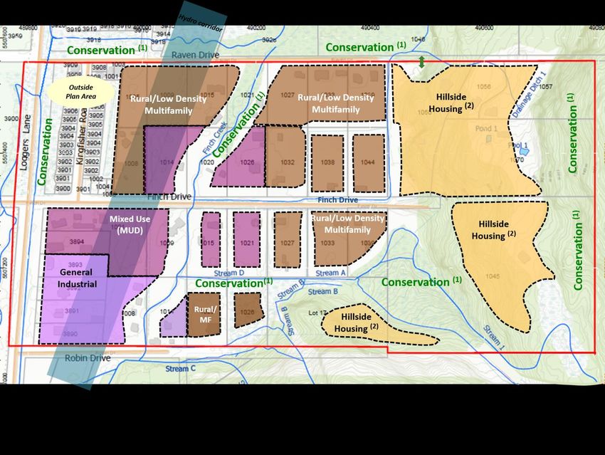
Table of Contents                                          List of Figures
1.      Introduction
          Plan Area                                         3    Figure 1    Plan Area                              3
          Plan Purpose                                      4
                                                                 Figure 2    OCP Designations                       6
          Public Input                                      5
                                                                 Figure 3    Current Zoning                         6
2.      Background
                                                                 Figure 4    Existing Land Use                      7
         OCP                                                6
         Current Zoning                                     6    Figure 5    Current Population and Jobs (est.)     7
         Current Land Use                                   7    Figure 6    Archaeological Potential               8
         Population and Housing Growth                      7    Figure 7    Current Environmental Conditions       9
         Rental and Affordable Housing                      8    Figure 8    Existing Watercourses                  10
3.      Development Issues                                       Figure 9    Slope Gradients                        11
         Environment                                        9    Figure 10   Flood Hazard                           12
         Steep Slopes | Hazard Assessment                   11
                                                                 Figure 11   Existing Stormwater Infrastructure     13
         Flood Hazard                                       12
         Drainage                                           13   Figure 12   Existing Water Infrastructure          15
         Servicing Infrastructure                           15   Figure 13   Existing Sewer Infrastructure          15
         Other Major Utilities                              16   Figure 14   Fortis and BC Hydro Corridors          16
         Transportation                                     17
                                                                 Figure 15   Major Transportation Routes (OCP)      17
4.      Neighbourhood Vision                                19   Figure 16   Active Transportation Routes (OCP)     18
         Guiding Principles                                 19
                                                                 Figure 17   Future Transit                         18
5.      Land Use Policies – Schedule A Plan                 20   Figure 18   Future Land Use Plan                   20
          5.1 Natural Environment                           21
                                                                 Figure 19   Recommended Habitat Protection Areas   22
          5.2 Rural/Low Density Multifamily                 25
          5.3 Hillside Housing                              29   Figure 20   Slopes and Geotechnical Setbacks       30
          5.4 Employment Lands                              33   Figure 21   Potential Trail Locations              37
          5.5 Neighbourhood Amenities                       35   Figure 22   Best School Routes                     38
          5.6 Connectivity: Moving Around                   37
          5.7 Infrastructure                                40
          5.8 Energy and Climate Change                     42

6.      Implementation                                      43

     Loggers East Neighbourhood Plan - February 9, 2021 - V.7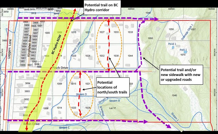
INTRODUCTION
1   PLAN AREA

    The Loggers East
    Neighbourhood Plan area is
    located east of Loggers Lane
    between Raven Drive to the
    north and Robin Drive to the
    south, located adjacent to
    the newly developed
    Ravenswood neighbourhood
    to the north and west.

                                                  Figure 1 Plan Area

    Loggers East Neighbourhood Plan - February 9, 2021 - V.7           3
INTRODUCTION
1 PLAN PURPOSE
The Neighbourhood Plan is intended to provide Inventory of employment generating uses
direction for future land use, employment, and identification of lands to be reserved for
The Loggers East housing, recreation and services within the employment;
neighbourhood is a mostly context of neighbourhood views, natural
Healthy built environment principles,
rural community between constraints and growth-related policies. When
including walkability, concentration of uses
finalized, the Neighbourhood Plan will be
Raven Drive and Robin Drive and services, transportation, proximity to
adopted as an amendment to the OCP.
comprised of rural, natural areas and green spaces, accessible
As described in the OCP, the scope of the and affordable housing and food, and
residential and industrial
Loggers East plan includes: opportunities for social connections;
properties. Defined by large
A detailed land use plan, including industrial, Agricultural opportunities, including local
parcels sizes, serviced and
agricultural and residential land uses and food production, as well as rural uses such
centrally located close to consideration of neighbourhood nodes; as kennels;
Downtown, Business Park
Density targets and housing mix for build Design guidelines, including consideration
and recreational facilities, the out of the sub area; of sustainable design and technologies;
area is seeing growth
Inventory of natural hazards and hazard Climate change mitigation and adaptation
interests rising. Loggers East mitigation/response strategies; measures;
is identified in the District of
Inventory of environmentally sensitive areas Strategies to address stormwater,
Squamish Official and wildlife habitats, and identification of groundwater, drainage and water quality
Community Plan (OCP) as a significant, contiguous areas for protection issues in order to mitigate impacts on
“Neighbourhood Planning and restoration; existing natural or developed areas; and
Area” where a detailed plan Inventory of existing recreational values and Consideration of opportunities to increase
is required prior to major opportunities for trail corridors, parks, open connectivity to other neighbourhoods in
space and greenway corridors; Squamish.
new growth.
Loggers East Neighbourhood Plan - February 9, 2021 - V.7 4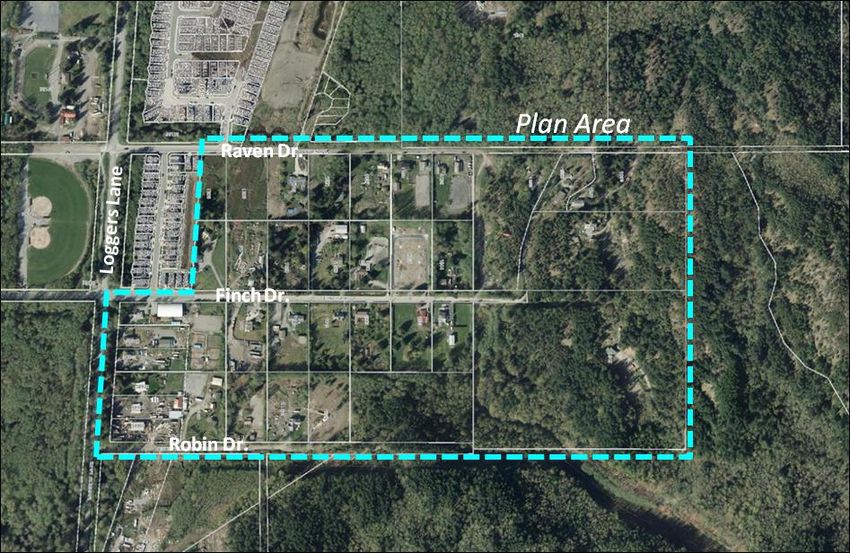
INTRODUCTION
1   PUBLIC INPUT
                                         The District of Squamish initiated a public           Public engagement regarding the draft
                                         engagement process for the Loggers East               Neighbourhood Plan in fall of 2020 generated
                                         Neighbourhood Plan in the fall of 2019.               very different responses. The majority of
                                                                                               respondents supported the environmental
                                         Community Engagement                                  policies, although some individual owners were
                                         Communication with area residents began with          concerned with possible loss of future density on
                                         an early mail out to residents/property owners, a     their properties. Many respondents objected to
                                         web page on the District website, online survey       the proposed agricultural use on a portion of the
                                         and an Open House held on October 23, 2019.           Rural/Multifamily designated properties,
                                         These steps provided background information           indicating this would reduce housing
                                         including links to technical reports completed as     affordability. Other responses noted that the
                                         part of the plan process.                             proposed industrial and/or mixed-use
                                         Due to the Covid-19 emergency, typical Open           designations would bring too much commercial
                                         Houses were not held to review the draft plan.        or industrial development to the neighbourhood.
                                         Instead, in the fall of 2020 a notice was mailed to
                                         residents/property owners, followed by an online
                                         open house and an online survey.

                                         What We Heard
                                         During the early engagement in 2019, the key
                                         messages received from survey responses
                                         indicated concerns with preserving the rural
                                         lifestyle of the neighbourhood, environmental
                                         protection, future traffic impacts and limited
                                         neighbourhood amenities. There was some
                                         support for additional housing and local
                                         commercial uses.

    Loggers East Neighbourhood Plan - February 9, 2021 - V.7                                                                                       5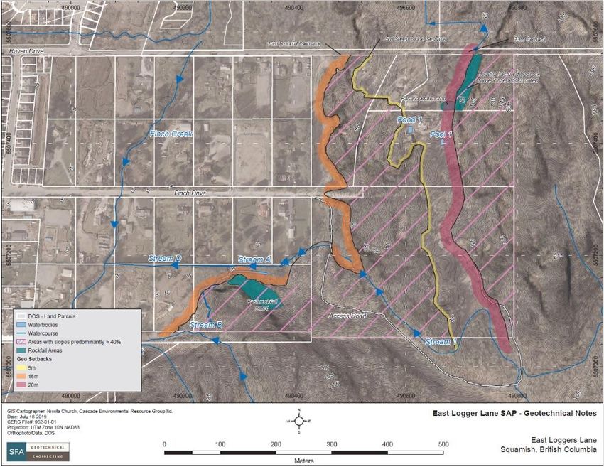
BACKGROUND
2   CURRENT PLANNING POLICY

    Official Community Plan (OCP)
    The Loggers East neighbourhood is designated as Residential
    Neighbourhood in the OCP. These areas are intended to accommodate a
    diverse mix of housing and employment forms to create complete
    neighbourhoods. OCP policies support increasing the range of attached
    multifamily housing types to create compact neighbourhoods and
    maximize efficient use of municipal infrastructure and transportation.
    Industrial/Business use is designated for lands to the south on Loggers
    Lane and northeast of the neighbourhood. Lands to the west and north
    are designated Parks, Greenway and Recreation and Conservation &
    Ecological Reserve. Lands further east and south are designated for
    Future Residential (long term).

                                                                                   Figure 2 Official Community Plan Designations
    Current Zoning
    The current zoning in the neighbourhood is a mix of residential and rural
    zones, predominantly RS-1 (Residential One) in sloped areas and RL-1
    (Rural Residential) which allows for single and two unit dwellings and rural
    uses such as kennels/horse stables. One property zoned RMH-2
    (Residential Modular Homes) provides for clustered single family homes.
    Directly north and to the west, lands are zoned CD-38 (Small Lot Single
    Family) and CD-76 (Sport facilities/Recreation) for the Nordic Legacy Park.
    One property on Loggers Lane/Finch Drive is zoned CD-79
    (Agriculture/Rural). Land directly south of Robin Drive on Loggers Lane is
    zoned I-7 (Rock Processing). Surrounding areas to the south and east are
    mainly zoned Resource and are currently undeveloped.

                                                                                   Figure 3 Current Zoning
    Loggers East Neighbourhood Plan - February 9, 2021 - V.7                                                                       6
BACKGROUND
2   LAND USE AND POPULATION
    Current Land Use
    The Loggers East Plan area is approximately 44 hectares in size, representing
    about 2% of land within the Squamish Growth Management Boundary. The
    area currently consists primarily of single family dwellings, home businesses
    and industrial storage uses. Much of the area consists of small acreages
    (approx. 0.8 ha in size) creating a rural character throughout the
    neighbourhood. The east sloped portion of the Plan area consists of larger
    parcels (RS-1 zone), with both vacant land and residential uses. Figure 4
    outlines the current land uses by zone and parcel areas. As shown, there are
    36 parcels in use for single dwelling units, while the remainder are vacant. No
    properties are currently assessed as industrial or commercial use, although
    there are 10 businesses holding a license in the area for business activities
    such as home office, carpentry and interior design, dog boarding and training,
    and transportation/industrial storage and repair representing 20 to 30 jobs.

    Potential Population and Housing Growth                                            Figure 4 Existing Land Use
    Although the Loggers East area currently consists of less than 40 households,
    combined with the Ravenswood neighbourhood, the area population is
                                                                                                        Current          Additional est.         Long-term est.
    nearly 550. In terms of accommodating growth in housing units, the Loggers
                                                                                      Area
    East neighbourhood is estimated to have infill potential for approximately                       Housing            Housing                  Housing
                                                                                                             Pop.                     Pop.               Pop.
    790-1100 housing units based on the designations shown on the land use                           Units              Units                    Units
    plan Schedule A. This represents about 7% of future growth within the
                                                                                                                           810- 2,105-             845- 2,195-
    current Growth Management Boundary. The Rural/Low Density Multifamily             Loggers East       36        90
                                                                                                                          1,130 2,940             1,165 3,030
    area could sustain between 335-450 additional units, while the Hillside
    Housing area could accommodate 335-500 additional units. The lower                Kingfisher/
                                                                                                        175       450             -          -      175     450
                                                                                      Falconcrest
    numbers represent ground-oriented housing, while the higher numbers
    anticipate some low-rise apartment units. An additional 140-180 units are                                              810- 2,105-            1,020- 2,645-
                                                                                      Total             210       540
    estimated for the Mixed Use Development area. Figure 5 indicates overall                                               1130 2,940              1,340 3,480
    projections for Loggers East and the broader Ravenswood area.
                                                                                      Figure 5 Current and projected population and housing units
    Loggers East Neighbourhood Plan - February 9, 2021 - V.7
                                                                                                                                                                  7
BACKGROUND
2   LAND USE

    Rental and Affordable Housing; Child Care Facilities                  Archaeological Potential
    Loggers East does not have any purpose built rental housing           A portion of the Loggers East neighbourhood north of Finch Drive is
    units or child care facilities. There are less than 10 accessory      identified as having moderate archaeological potential, based on an
    dwelling units (suites, carriage homes) currently registered in the   overview archaeological assessment completed in 1997 for the Ministry
    area, including the Ravenswood neighbourhood. There is one            of Forests and Archaeology Branch, Ministry of Small Business. The
    residential child care provider in Ravenswood. According to the       report provided an overview of locations believed to have the greatest
    2018 Housing Needs Assessment, Squamish is facing a shortage          potential for cultural and archaeological significance. Lands further
    of affordable and market rental housing. Based on current             north along the Mamquam River are indicated as having high potential.
    demand for rental housing, it is estimated that the need for          Archaeological sites on both public and private land are protected
    purpose built affordable and market rental housing will be            under the Heritage Conservation Act and must not be altered without a
    around 30% of all units. For Loggers East, the need for rental        permit issued by the Province. Developers are responsible for
    housing will be between 245-340 housing units of which 40%            undertaking any assessment required to determine the presence of
    should be affordable. Plan policies provide further detail on the     archaeological resources.
    requirements for rental housing in the Rural/Low Density
    Multifamily and Hillside Housing designations.

                                                                          Figure 6 Archaeological Potential (moderate potential shown in orange)

    Loggers East Neighbourhood Plan - February 9, 2021 - V.7                                                                                       8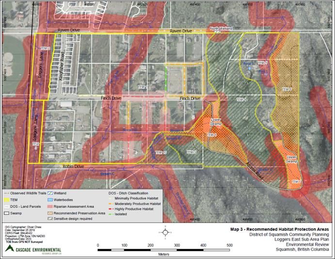
BACKGROUND
3 ENVIRONMENT
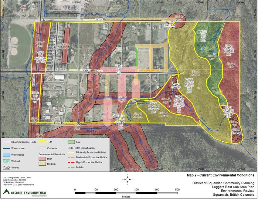
As part of the neighbourhood plan process, an
Environmental Review[1] was completed to assess
overall environmental conditions, identify
environmentally valuable resources (EVRs),
environmentally sensitive areas (ESAs) and wildlife
habitat. The report identified sensitive ecosystems in
the Plan area associated with high-value riparian
habitats, red and blue-listed ecological communities
in wetland/swamp and young forest areas, and an
abundance of other EVRs such as coarse woody
debris, wildlife trees and rock outcrops that provide
habitat for reptiles, birds and small mammals. A well-
established wildlife trail was observed in the
northeast portion of the Plan area. Extensive ditching
on roads and along property lines is also present
throughout the neighbourhood, with some ditches
connecting to the stream system and having high to
moderately productive habitat.
Lands shown in red on Figure 7 with High
environmental sensitivity are designated as
Conservation on the Schedule A Land Use Plan.
Sensitive design practices are recommended for areas Figure 7 Current Environmental Conditions
of medium sensitivity shown in yellow on Figure 7.
1 https://squamish.ca/assets/Planning/Loggers-East/72068f8f2e/190926_Loggers-
East-Sub-Area-Environmental-Review_Final-web.pdf
Loggers East Neighbourhood Plan - February 9, 2021 - V.7 9
BACKGROUND
3   ENVIRONMENT cont.

    The Loggers East neighbourhood contains
    significant waterbodies, with most
    connecting to the Finch Creek/Loggers
    Lane creek system. Finch Creek flows
    southwest through the Plan area and into
    Loggers Creek approximately 300 m
    southwest of the Plan area, which then
    flows approximately 1.5 km into the
    Mamquam Blind Channel. Tributary streams
    flow from upper swamp and bench areas
    west and into the Finch Creek south of the
    Plan area. Finch Creek is a significant
    watercourse providing habitat for
    regionally significant fish (cutthroat trout),
    coho salmon and coarse fish species, as
    well as riparian habitat for wildlife living in
    and travelling through the Loggers East
    neighbourhood. Drainage ditches are also
    part of the stream system habitat as
    indicated on Map 7.

                                                               Figure 8 Existing Watercourses

    Loggers East Neighbourhood Plan - February 9, 2021 - V.7                                    10
BACKGROUND
3 STEEP SLOPES | HAZARD ASSESSMENT
The Loggers East neighbourhood is characterized by
generally flat and low topography in the west section, with
steep rocky slopes in the eastern and southern portions of
the neighbourhood. As background to the Loggers East
plan, an overview Slope Hazard Assessment2 was
completed to review the slope and geotechnical
conditions in more detail. The report indicates the sloped
areas consist primarily of bedrock and the most critical
geological hazard is expected to be rockfall. Large portions
of the bedrock outcrops were noted to be highly fractured,
especially along the steep rock bluffs, therefore rockfall is
expected to continue over time. The report also indicates
the potential for landslides, particularly if oversteepening
of existing slopes were to occur or vegetation removed.
Current OCP policies recommend no single family
development where slopes exceed 25%, possible
development of multi-family development up to 40%
slopes, and no development of slopes over 40%. Figure 9 Slope Gradients (approx.)
Approximate slope gradients are shown on the adjacent
map, indicating two main north-south bands of relatively
flat developable area within the steep sloped properties, as
well as some smaller pockets requiring detailed
assessment to determine suitable road access and building
sites. Steep slopes also affect Raven, Finch and Robin
2 https://squamish.ca/assets/Planning/Loggers-East/4df7b43982/1188-East-Loggers-Neighbourhood-
Drives, each of which encounters steep grades with any Slope-Hazard-Assessment-September-6-2019-web-v2.pdf
eastward extension.
Loggers East Neighbourhood Plan - February 9, 2021 - V.7 11BACKGROUND
3 FLOOD HAZARD
Much of the Loggers East neighbourhood is within the Squamish Historic Flood and Dike Protection
flood hazard area and overland flow area as shown on Figure 10. The neighbourhood has been significantly affected by earlier
The probability of river flooding is considered low compared to flooding. Historically, the Mamquam River flowed through this area,
other areas such as Downtown or Brackendale due to the but during a large flood in 1921 the Mamquam River breached its
protection provided by a dike along Centennial Way to the north. banks, changing course towards the Squamish River. This diversion
Coastal flood hazard is also considered low, although on-going sea was made permanent by the 1922 when the lower portion of the
level rise will likely exacerbate existing drainage issues in the Mamquam River was diked north of Brennan Park along Centennial
neighbourhood. New development will be affected both by flood Way. This diking provided protection for the Loggers East
hazard and the high water table, meaning that properties may need neighbourhood from Mamquam River flooding, but also confined
to be raised and/or that the first storey of new buildings will be the river to a relatively narrow corridor and disconnected important
used for non-habitable uses such as parking and/or storage, with tidal channels, wetlands and critical spawning habitats. In 2005, the
living space on upper floors. Additional measures may be required Mamquam Reunion project was initiated (as a joint project of the
with any future redevelopment of these properties, subject to site- Squamish River Watershed Society, Squamish Nation, District of
specific assessment during the development application process. Squamish, Fisheries and Oceans Canada (DFO) and other agencies)
to reintroduce water to critical spawning and rearing habitat. Over
the course of 2005-2012, several culvert crossings, intakes and new
channels were constructed, creating improved opportunities for fish
passage to their critical habitats.
Figure 10
Flood Hazard
Loggers East Neighbourhood Plan - February 9, 2021 - V.7 12BACKGROUND
3 DRAINAGE
Much of the Loggers East neighbourhood is low-lying and has Integrated Stormwater Management Plan (ISMP)
known high water table and drainage issues. Loggers East drains via To address the broader drainage issues in the municipality, the
Loggers Creek to Wilson Slough and Mamquam Blind Channel. District initiated an Integrated Stormwater Management Plan
Wilson Slough drains via culverts under Loggers Lane into the Upper
covering the developed areas in Squamish south of the
Mamquam Blind Channel. During coinciding high tides and heavy
Mamquam River in 2019 . As part of that process, a stormwater
rainfall there are drainage issues evident in the Raven/Robin areas.
management review 3 for Loggers East was completed in mid-
Current drainage infrastructure consists of ditches and culverts on
2020 to assess the physical conditions, current watershed health
Finch Drive and Robin Drive, with storm service lines on Loggers
and natural assets, and to assess the stormwater management
Lane and Kingfisher Road as shown on Figure 11. Several of the
implications of new development. An assessment of hydrological
ditches also have high habitat value. New developments will be
conditions and potential infiltration characteristics was also
required to complete stormwater management plans to manage on-
site and off-site drainage and protect environmental values in completed to assist in developing appropriate stormwater
accordance with the policies and objectives laid out in the District’s management practices, and a stormwater model was also
forthcoming Integrated Stormwater Management Plan. developed to assess stormwater routing and land use impacts.
The review indicated the neighbourhood is underlain by two
unconfined aquifers which have a high vulnerability to
contamination. Groundwater levels are influenced by the stage of
the Mamquam River, surface topography, surface water in the
creeks and to some degree by tide levels given proximity to the
Mamquam Blind Channel. The study confirms the eastern part of
the neighbourhood has high groundwater levels and localized
flooding at low-lying elevations which is accentuated during
winter months (seasonally) or during simultaneous occurrence of
high river stage (seasonally) with high tide (daily).
Figure 11 Existing Stormwater Infrastructure
3 https://squamish.ca/assets/Planning/Loggers-East/acac4db70d/2020-07-17-Phase-2-
ISMP-Loggers-East-Review-DRAFT_Rev2-web.pdf
Loggers East Neighbourhood Plan - February 9, 2021 - V.7 13BACKGROUND
3 DRAINAGE
Integrated Stormwater Management Plan (ISMP) – cont.
The report also assessed the implications of future land uses on the
extent of pervious/impervious areas. Preliminary model results show
significant impacts of future development on stormwater runoff due to
loss of vegetation and increased impervious surfaces. Based on the
results of soil, groundwater and aquifer mapping, much of Loggers East
has low potential for stormwater infiltration, and any infiltration-based
stormwater management practices will likely need to be combined with
subsurface or other forms of storage.
The stormwater review highlights that forested and vegetated areas are
important natural assets in Loggers East that provide rainwater
attenuation, evapotranspiration and infiltration (flood protection and
erosion protection) functions. Forests also provide water filtration,
groundwater flow recharge, climate regulation (carbon storage) and
temperature regulation, air quality and habitat functions. The report
estimates that the combination of future development (if unmitigated)
and climate change could potentially increase the flows through the
existing culverts and storm sewers beyond current capacity. For these
reasons, neighbourhood plan policies are focused on reducing
stormwater impacts and providing on-site storage solutions.
Loggers East Neighbourhood Plan - February 9, 2021 - V.7 14BACKGROUND
3 SERVICING INFRASTRUCTURE
As a largely rural area currently, the Loggers East
neighbourhood will require upgrades to the water, sanitary
sewer and drainage infrastructure with any new development.
Water Supply
The existing water distribution system as shown on the
adjacent map consists of an 18” water main on Loggers Lane,
8” water mains on Raven, Robin and Finch Drives, with smaller
service lines in other parts of the neighbourhood. Upgrading
of water service will be needed for new development,
including upgrades to meet fire flow requirements.
Replacement of some portions of the existing water main may
Figure 12 Existing Water Infrastructure
also be needed if higher density is proposed. The water system
may also need to be looped to achieve necessary fire flows.
Sanitary Sewer
The existing sanitary sewer system is shown on the adjacent
map, consisting of sewer mains on Finch Drive, Loggers Lane
and Kingfisher Road with a lift station near Brennan Park on
Loggers Lane. New development will be required to extend
and/or increase the size of sewer mains and likely upgrade or
replace the sewer lift station depending on future
development density, as the lift station is at or near capacity.
Extension of sewer service may not be feasible in some areas
due to slope. Figure 13 Existing Sewer Infrastructure
Loggers East Neighbourhood Plan - February 9, 2021 - V.7 15BACKGROUND
3 OTHER MAJOR UTILITIES
Hydro Corridor
The Squamish BC Hydro major transmission line corridor runs diagonally
to the east of Loggers Lane, affecting future uses on some 10-12
properties in the Plan area. Within this 98 metre wide corridor, residential
uses are not permitted by BC Hydro, although compatible uses such as
trails, gardens or parking may be allowed (subject to BC Hydro approval).
Gas Pipeline
A Fortis gas pipeline runs east-west along the Finch Drive road right of
way, then southeast through private lands. No structures or residential
uses are permitted within the right of way. (Note: the 40m buffer shown is
not a setback area, it represents the “call before you dig” area). Fortis BC
received an Environmental Assessment Certificate in 2016 for construction
of a new 24” high pressure gas pipeline to serve the proposed Woodfibre
LNG plant. Fortis is currently evaluating route options for this pipeline to
Figure 14 Fortis and BC Hydro Corridors
determine whether the new gas line will be installed within the existing
right of way corridor along Finch Drive or an alternative route.
Loggers East Neighbourhood Plan - February 9, 2021 - V.7 16BACKGROUND
3 TRANSPORTATION
Road Network
Loggers Lane is the major road directly serving the neighbourhood,
connecting to Highway 99 via Finch Drive. Raven, Finch and Robin
Drives provide local access to properties and are not through roads
due to steep terrain in the eastern areas
The OCP indicates a potential long-term route extending eastward
from Finch Drive, as well as a future route extending north from
Valleycliffe. The feasibility and routing of these potential roads will
need to be considered as part of any future development plans for
lands in the eastern portion of the are and further east beyond the
Plan area (indicated as long-term development areas in the OCP).
Road connectivity to lands beyond the Loggers East neighbourhood
owned by the Squamish Nation has been highlighted as an important
consideration by Squamish Nation staff and will require detailed
review at the time of any future development applications.
With any new development, improvements to fronting roads will be Figure 15 Major Transportation Routes (from OCP)
required. Upgrades typically include curb, gutter, sidewalk, street
lighting and underground services. Neighbourhood plan policies
recommend alternative standards be applied to Loggers East to
protect habitat adjacent to roads.
Loggers East Neighbourhood Plan - February 9, 2021 - V.7 17BACKGROUND
3 TRANSPORTATION
Active Transportation Transit
The Corridor Trail located on the west side of There is currently no transit
Loggers Lane provides a multi-use pathway for service available to the Loggers
pedestrians and cyclists. With any increase in East neighbourhood, but the
density in the neighbourhood, additional north- area has been indicated as a
south pedestrian connections between Raven future expansion area in the
Drive, Finch Drive and Robin Drive will also be Transit Future Plan (BC Transit).
required to improve local connectivity. Plan The transit plan recommends
policies also recommend use of the BC Hydro introducing local transit service
corridor for trails. to developing areas including
Loggers Lane by 2025 (transit is
already available to Brennan
Park). Additional density in the
Loggers East neighbourhood
and areas to the north at
Centennial Way will be key to
developing transit service.
Figure 16 Active Transportation Routes (from OCP)
Figure 17 Future Transit
Loggers East Neighbourhood Plan - February 9, 2021 - V.7 184 Neighbourhood Vision Guiding Principles
▪ Natural Assets define this neighbourhood - streams, wetlands, forested areas,
and steep slopes are key features of the neighbourhood. Environmental
protection and enhancement of these natural assets will be essential with any
new development.
▪ Mixed Uses – build on the unique mix of uses that characterize Loggers East
with a balance of employment, rural and housing uses. Avoid a growth pattern
that is mainly residential and presents few housing choices.
▪ Stormwater/Drainage – minimize hard surfacing and building footprints; retain
or replace vegetation to preserve and restore riparian areas; store stormwater
on-site.
▪ Food Production/Agriculture – integrate new and existing agricultural and
Loggers East will continue to be a unique mixed use related rural uses as the neighbourhood grows.
neighbourhood with a strong sense of community, that ▪ Employment Lands – retain and expand lands for use by industrial and
protects the high value natural assets of the area and commercial uses, including flexible spaces in mixed use areas. Ensure that jobs
provides for employment and agricultural/rural uses grow along with population growth.
while also accommodating a moderate amount of ▪ Connectivity – create a walkable and connected neighbourhood by prioritizing
growth with of a diverse mix of housing and flexible active transportation and recreation connections over vehicle movement; ensure
employment spaces, connected by common parks and streetscapes are adapted to the unique and sensitive features of the area.
open spaces. ▪ Housing Mix – provide for a diverse range of housing types and tenures with
lower densities appropriate to the area; minimize impacts on natural assets.
Address the lack of affordable and market rental housing units in the area.
▪ Neighbourhood Amenities – provide basic neighbourhood services such as
child care within walking distance of new residential growth; focus on livability
and connectedness through provision of trails, local playgrounds/parks and
gathering spaces.
▪ Build to Respond to Climate Change – Reduce greenhouse gas emissions
(GHG) and eliminate non-renewable energy use associated with all new growth.
Loggers East Neighbourhood Plan - February 9, 2021 - V.7 19POLICIES
5.0 SCHEDULE A LAND USE PLAN
The Loggers East
Neighbourhood Plan land
use policies are intended to
guide future growth with a
focus on careful integration
with the existing
neighbourhood.
Five land use designations
apply to the properties in
the Loggers East
neighbourhood. Policies for
each of the land use
designations shown on the
Schedule A Land Use Plan
are provided in the
following sections.
Figure 18 Schedule A Future Land Use Plan
Loggers East Neighbourhood Plan - February 9, 2021 - V.7 20POLICIES
5.1 ENVIRONMENT
Objectives:
The Loggers East • To protect and enhance the ecological values of the a) Riparian Assessment Areas (red colour) associated
Loggers East neighbourhood. with Finch Creek, Loggers Lane Creek, tributary
neighbourhood
• To ensure any new development minimizes habitat streams, ditches, and wetlands/swamps shall be
contains significant loss and fragmentation and rehabilitates and protected and enhanced with any new
environmentally enhances previously degraded natural areas. development in accordance with OCP
Development Permit Area No.1 (DPA1) guidelines.
valuable resources • To recognize the value of the natural assets as part of
These areas are shown as Conservation on
(EVRs) associated with municipal infrastructure.
Schedule A Land Use Plan.
high value riparian or Environment Policies
b) Recommended Preservation Areas (orange cross
wetland (swamp) 1. All lands within the Recommended Habitat Protection hatch) include red and blue listed ecological
Areas shown on Figure 19 are required to obtain a communities with an abundance of EVRs
habitat that support a
Development Permit in accordance with the DPA 1 comprising over 70% of the TEM-6, TEM-7 and
wide range of fish, (Environment) guidelines of the OCP in order to TEM-8 polygons are also shown as Conservation
amphibians, reptiles protect fish and aquatic habitat, associated riparian on the Land Use Plan. Preservation and retention
of these areas, including the established wildlife
and other wildlife areas and wetlands, including ditches, and to protect
corridor at the top of cliffs in TEM-6 needs to be
species. Forested terrestrial habitats. The exact extent of habitat
considered with any future development.
protection areas will be determined at the time of
upland areas include c) Sensitive Design Areas (green diagonal lines) on
development permit application.
red and blue-listed Figure 19 are lands where a portion of the
2. The sensitive ecosystems shown on Figure 19 shall be property contains high value EVRs. Potential
ecological communities protected and preserved as follows (note: the habitat for amphibians, reptiles, wildlife trees and
and established wildlife Environmental Review should be referenced for the wildlife movement corridor should be
movement corridors. habitat details in each TEM polygon): protected with any development. These areas are
indicated as Hillside Housing on the Land Use
Plan; site specific evaluation of habitats and careful
site design is required prior to tree/vegetation
removal or development in these areas.
Loggers East Neighbourhood Plan - February 9, 2021 - V.7 21POLICIES
5.1 ENVIRONMENT
Development Guidelines
3. The following recommendations of the
Environmental Review apply to new
development in Loggers East:
a) Development in Loggers East should
follow guidelines and recommendations
outlined in Environmental Best
Management Practices for Urban and
Rural Land Development (BC MOE, 2014).
This includes best management practices
for storm water, pollution prevention,
wildlife, and ecosystem management;
b) All Streamside Protection and
Enhancement Areas (SPEAs) should be
viewed as significant habitat and
protected; riparian buffers adjacent to
watercourses will also protect wildlife use
of water features;
c) A Riparian Areas Regulation assessment
should be completed by a QEP early in
the design process to inventory
watercourses and riparian areas that may
not be indicated in the Environmental
Review Figure 19 Recommended Habitat Protection Areas
Loggers East Neighbourhood Plan - February 9, 2021 - V.7 22POLICIES
5.1 ENVIRONMENT
d) Maintain vegetated corridors between h) Low impact creek crossing such as clear l) Any construction activities anticipated to
watercourses and riparian areas where span bridges should be used where have any potential effect on water
possible to provide wildlife movement stream crossings are necessary. quality in water bodies on or adjacent to
corridors and prevent further Permitting for stream crossings is the study area should follow best
fragmentation of available habitat. required from Ministry of Forests, Lands, practices and be monitored by a QEP;
Incorporate amphibian and small Natural Resource Operations and Rural m) All vegetation removal should occur
mammal eco-passages under roadways Development under the Water outside of bird nesting season (April 1 to
via culverts to preserve and enhance Sustainability Act; August 31) or should be preceded by a
connectivity; i) An invasive species survey and survey for the presence of active bird
e) Amphibian and reptile dispersion routes management plan prepared by a nests by a QEP and all active nests must
shall be identified and protected; Qualified Environmental Professional be protected by a suitable buffer until
f) The wildlife trees in the eastern and (QEP) prior to any development; nesting is complete. Heavy construction
southeastern areas as well as forested j) A Stormwater Management Plan and a works during this period should also be
areas within riparian fringes have Sediment and Erosion Control Plan are preceded by a nesting survey for
potential to provide nesting required prior to any site development songbirds, raptors, and species at risk
opportunities for western screech owl or construction to prevent release of any and a ‘quiet’ buffer maintained around
and other bird species. Preservation of sediment, sediment-laden water or any active nests. Particular attention
TEM-6,7 and 9 will protect this habitat. If untreated stormwater into watercourses should be paid to:
development is proposed for TEM-4, or Riparian Assessment Areas; • forest edges and openings for
TEM-9 or TEM-10, a site-specific survey k) Protect SPEAs during and after band-tailed pigeon;
and habitat plan is required; development. Silt fencing and orange • rock outcrops and sparsely
g) Light pollution in the vicinity of sensitive construction fencing should be installed vegetated areas for common
habitats (i.e. riparian areas or rock along riparian buffer boundaries prior to nighthawk, black swift and barn
outcrops) should be minimized by construction. A permanent fence, swallow; and
directing permanent/residential lighting vegetated barrier or signage should be • wildlife trees and snags for
away from these areas; incorporated in the development design western screech-owl.
to prevent intrusions following
construction;
Loggers East Neighbourhood Plan - February 9, 2021 - V.7 23POLICIES
5.1 ENVIRONMENT
n) Bear-safe design shall be provided for • northern red-legged frog, the opportunity to improve existing
any garbage/composting facilities and • western toad, riparian habitat by carefully relocating
landscaping any pieces of CWD needing to be
• cutthroat trout, and removed into the riparian areas.
o) Avoid disturbance of rocky outcrops
where possible and minimize impact • salmonid species. 4. Public ownership - In accordance with
when disturbance is unavoidable. If any q) Prior to any land clearing, areas to be OCP policies, new development areas
blasting or other disturbance of rocky cleared should be surveyed by a QEP for should exclude the protected riparian
outcrops is to occur, it should occur potentially occurring plant species at risk. areas or other sensitive areas; the District
between late spring and early fall. Prior Surveys for Vancouver Island beggar ticks may recommend public ownership of
to any disturbance of these habitats, and Roell’s brotherella should be environmentally sensitive lands at the
targeted surveys should be conducted by conducted in spring or early summer time of development
a QEP for the following species at risk (if while surveys for mosses can be application/rezoning.
any are located, appropriate mitigation conducted at any time of year. If any are 5. Wildfire Protection – the District
measures will be determined): found, these can be carefully relocated to anticipates adopting a Wildfire
• northern rubber boa, and suitable areas nearby that will not be Protection Development Permit Area
disturbed during construction activities. (Wildfire DPA) in 2020 that will apply to
• common nighthawk, black swift and
barn swallow nests, particularly r) It is recommended that as much coarse portions of lands in Loggers East. All new
between April 1 and August 31. woody debris (CWD), of varying sizes and developments in the Wildfire DPA are
stages of decay be maintained as required to obtain a development permit
p) Prior to any construction activities within possible. CWD was noted in Polygons in accordance with the DPA guidelines.
the riparian areas for any necessary creek TEM-4, TEM-6, TEM-7, TEM-8, TEM-9,
crossings, targeted surveys and salvages and TEM-10, with an abundance in the
must be conducted by a QEP for the TEM polygons previously noted as
following species at risk and significant preservation candidates. If CWD is to be
species. If any are found, they can be removed, this should occur between late
relocated to suitable riparian areas spring and early fall when mammals are
nearby. less likely to be seeking shelter. There is
Loggers East Neighbourhood Plan - February 9, 2021 - V.7 24POLICIES
5.2 RURAL/LOW DENSITY MULTIFAMILY
Objectives: will typically be lower than other areas of the
Loggers East currently District.
• To provide for a diverse mix of future housing
provides a unique setting 3. Neighbourhood amenities outlined in policy
forms and tenures including rental housing;
with rural and residential Section 5.4 shall be provided with any new
• To provide housing that retains a sense of development.
uses, yet is close to the
openness and respects the environmental
Downtown, employment Housing Forms
qualities and drainage conditions of the Loggers
areas and other 4. Housing forms supported in the Rural/MF area
East neighbourhood;
include clustered small cottages 100 sq.m. or less in
developing
• To support small-scale agricultural uses; size, tiny homes (typically less than 50 sq.m. in size),
neighbourhoods. This townhouses, small duplexes, stacked townhouses
• To increase local food production, food assets
neighbourhood provides and other ground-oriented housing. Apartments up
and healthy food access in the neighbourhood.
a special opportunity for to 3-4 storeys will be considered if compatible with
• To increase food security in the community. the character of the neighbourhood and adjacent
small-scale agricultural
Rural/Low Density Multifamily (Rural/MF) Policies uses, address shortage of rental housing and
uses and continuation of
additional environmental benefits are provided by
rural uses alongside 1. The Rural/MF designation applies to small acreage
the smaller footprint of apartment development.
compact infill areas of Raven, Robin, and Finch Drives, including a
number of properties with high ecological value of 5. New large or solely single-family development is
development. An not supported. Single residential uses in the
Finch Creek and tributary streams. Some properties
estimated 335-450 are also affected by the BC Hydro transmission line Rural/MF designation will be limited to a maximum
additional housing units corridor, while other parcels have relatively few size of 300 m2 (gross floor area) to retain land
constraints. available for future agricultural/rural and other
could be sustained within
open space uses. (Implementation: Zoning Bylaw
the Rural/Low Density 2. The Rural/MF designation provides for continuation amendment).
and development of rural and small-scale
Multifamily area.
agricultural uses while also allowing for infill
residential development at moderate densities that
Loggers East Neighbourhood Plan - February 9, 2021 - V.7 25POLICIES
5.2 RURAL/LOW DENSITY MULTIFAMILY
Base Density and Bonus Density Density Level Maximum density - based Amenities Provided (2)
6. Base residential density in the on net land area (1)
Rural/MF designation is 35 units/net Current zoning RU1 - 1 unit/0.8 ha Min. 5% public park dedication at subdivision (Local
hectare (14 units/net acre) for (1 unit/2 acres) Government Act requirement)
ground-oriented housing and 55 RS-1 - 1 unit/690m2
units/ha (22 units/acre) for
Density Options at Rezoning - Base density is:
apartments calculated on the net
developable land area (i.e. excluding • 35 units/hectare (14 units/acre) for ground-oriented housing. Min. 30% common open space (strata) required.
ESAs/Conservation areas). • 55 units/hectare (22 units/acre) for apartments. Min. 30% common open space (strata) required.
7. Three to four storey apartments Option 1 + 15% density Ground Oriented Housing:
with density ranging from 60-80 Min. 30% open space if a portion is activated as publicly
units/ha (24-32 units/acre) will be accessible park space and/or contains a public trail.
considered in accordance with
Apartments:
Policy 5.2.4.
Min.35% open space if a portion is activated as publicly
8. Additional density (bonus density) accessible park space and/or contains a public trail.
up to 60 units/hectare (24 Density bonus
options Option 2 +20% density Min. 30% open space if a substantial portion is activated
units/acre) for ground-oriented
as agricultural use or 30% or more of the property is
housing or up to 80 units/net
within environmental protection area.
hectare (32 units/acre) for
apartments will be considered Option 3 + 20% density If at a portion of the housing is rental housing
where developments propose to
Option 4 + 10% density With provision of 3 of energy climate change targets
significantly address community
open space, agricultural use, rental
housing or other community (1) Net land area excludes environmentally sensitive/Conservation areas and steep slopes as described in the
amenities described in Plan Section Neighbourhood Plan.
5.5 and in accordance with the (2) Some developments may propose a mix of amenities or combine density bonus options, to be evaluated at
following table. rezoning in accordance with the principle of additional density in exchange for greater public benefit.
Loggers East Neighbourhood Plan - February 9, 2021 - V.7 26POLICIES
5.2 RURAL/LOW DENSITY MULTIFAMILY
Lot Consolidation; Density Transfer Agriculture/Food Production
9. No more than two (2) parcels 12. Areas proposed to be activated to provide food
should be combined for production/agricultural uses will be protected
development unless significant with a covenant on the lands requiring
benefits to site design, continuous agricultural use by an approved
environmental protection or other community group, land trust, agricultural
community amenities is provided. operator or strata. The covenant will ensure the
10. Transfer of development potential land is protected in perpetuity as a community
from one property to another will asset and that regenerative/organic agricultural
only be considered where practices are followed.
significant environmental or food 13. Agricultural uses such as crop production,
production benefits are provided. greenhouses, sale of produce grown on-site,
Rental Housing grazing, community orchards, equestrian
facilities, kennels and other agricultural uses are
11. To address known demands for
supported on all Rural/MF properties.
rental housing, approximately 30%
(Implementation: Zoning Bylaw amendment).
of future housing units should be
rental housing units, of which 14. Agricultural use or other open space areas
approximately 40% should be should be located where they can be combined
affordable units as indicated in the with areas on adjacent parcels to create a larger
following table: agricultural area. Where applicable, the
agricultural use may be located within the BC
Overall Rural/MF Density 335-450
Units
Housing Hydro corridor, subject to BC Hydro approval.
Market Rental Need 60-80 15. Accessory structures for food processing,
Affordable Rental Need 40-55 equipment storage and gathering should be
provided in each agricultural area; shared
Total Rental Units Need 100-135
facilities between users is encouraged.
16. Developers are encouraged to work with the
Squamish Food Policy Council to determine
future agricultural uses for the neighbourhood.
Loggers East Neighbourhood Plan - February 9, 2021 - V.7 27POLICIES
5.2 RURAL/LOW DENSITY MULTIFAMILY
Rural/MF Development Permit Guidelines 20. Wherever possible, parking should
17. OCP Development Permit Area No. 3 be located at the rear or side of the
(Universal Guidelines) apply to new site to retain an attractive
multifamily residential development. streetscape;
Some of the more relevant guidelines, 21. Interior courtyards should not be
as well as new guidelines specific to the dominated by parking.
Loggers East neighbourhood, are:
17. Provide appropriate and sensitive
transitions between different scales
of buildings. This may require
increased setbacks from adjacent
properties, setback of upper storeys
and/or careful placement of windows
and outdoor spaces to prevent
overlooking;
18. Create a welcoming streetscape that
faces the neighbourhood instead of
inward;
19. Provide publicly accessible open
space adjacent to the street frontage
to create parklets with covered
gathering spaces and/or play areas
to provide opportunity for
neighbourhood interactions.
Loggers East Neighbourhood Plan - February 9, 2021 - V.7 28POLICIES
5.3 HILLSIDE HOUSING
Objectives:
The steeply sloping • To manage development in steep slope areas in a a) District servicing and road standards are met;
lands in the eastern manner that reduces the risk to life and property, b) A professional geotechnical assessment concludes the
prevents erosion and risks to down-slope properties. land can be safely developed (as per Guidelines for
and southern part of
Legislated Landslide Assessment for Proposed
the neighbourhood • To protect the visual and environmental qualities of the
Residential Developments in BC, APEGBC, revised May
sloped areas through careful site planning and
contains two main 2010);
clustered forms of development.
bands of potentially c) Other objectives of the Loggers East neighbourhood
• To avoid creating car-centric neighbourhoods and
developable areas plan regarding environmental protection and
ensure that housing is well connected by active
within the steep stormwater management are met; and
transportation and recreational linkages to other
slopes. An estimated neighbourhoods and recreational assets. d) The development is sensitively integrated with the
surrounding areas and meets Hillside Development
335-500 additional
Hillside Housing Policies Guidelines.
housing units could
1. Subject to site-specific geotechnical review and Housing Forms
potentially be
engineering assessment for access and servicing, 4. Mixed housing in the form of small duplexes,
developed in the residential use is supported in the Hillside Housing townhouses, tiny homes (typically less than 50 sq.m. in
Hillside Housing areas, designation as shown on Land Use (Schedule A). This size), stacked townhouses and low-rise apartments (3-4
depending on housing includes lands up to 40% slope as shown generally on storeys) are supported in Hillside Housing areas.
forms and ability to the Loggers East Slope Hazard Assessment report.
5. New large or solely single-family development is not
provide access to 2. All development, including roads and infrastructure, supported.
shall meet the recommended geotechnical setbacks
developable areas. and avoid rockfall hazard areas as shown on Figure 20.
3. In accordance with OCP policy, development is not
supported on lands predominantly over 40% slope.
These steeper areas may be considered for
development following site specific evaluation,
provided:
Loggers East Neighbourhood Plan - February 9, 2021 - V.7 29POLICIES
5.3 HILLSIDE HOUSING
Base Density and Bonus Density
6. Base density in the Hillside Housing designation is
35 units/net hectare (14 units/net acre) for
ground-oriented housing and 55 units/net hectare
(22 units/net acre) for apartments calculated on
the net land area (excluding steep slope and
environmental/conservation areas). Actual density
will be determined during the rezoning process
based on site-specific geotechnical assessment
and detailed design.
Rental Housing; Bonus Density
7. Additional density up to 60 units/ha (24 units/acre)
for ground-oriented housing and up to 80 units/ha
(32 units/acre) for three to four storey apartments
may be considered for applications proposing to
significantly address rental housing availability or
provide community amenities in accordance with
density bonus provisions of Policies 5.2.6 – 5.2.8.
8. Based on current demands, approximately 30% of
future housing units should be rental housing units,
of which approximately 40% should be affordable
units as indicated in the following table: Figure 20 Slopes and Geotechnical Setbacks
Overall Hillside Density 335-500 Housing Units
Commercial Land Use
Market Rental Need 60-90
9. Commercial uses such as child care or education facilities, or specialized service
Affordable Rental Need 40-60
uses such as restaurant or retreat centre may be supported, subject to site-specific
Total Rental Units Need 100-180 review of site conditions, neighbourhood impacts and provision of active
transportation.
Loggers East Neighbourhood Plan - February 9, 2021 - V.7 30POLICIES
5.3 HILLSIDE HOUSING
Hillside Development Guidelines
identify any slope stability hazards, assess the Minimum Setbacks
The District is preparing to develop Steep
safety of the site and propose any mitigation
Slopes Development Permit Area (DPA) 9. Unless otherwise determined to be safe by
measures necessary to ensure the safety of the
guidelines, anticipated to be in place by 2022. a qualified professional, minimum
proposed development and existing
Until the Steep Slopes DPA guidelines are setbacks (including buildings, hot tubs,
neighbouring development. swimming pools, landscape ponds and
adopted, the following development policies
will apply: Site Design: outbuildings) shall be as shown on Figure
To the Loggers East neighbourhood at the time 4. Locate buildings, roads and infrastructure 20, consisting of:
of rezoning, subdivision or development permit away from critical slope areas or areas a) a minimum 5 metre setback from the
application: where extensive regrading is required. top of any slope greater than 25%;
5. Avoid disturbing soils that provide b) where the slope is greater than 40%,
1. All development with slopes greater than the minimum setback shall be
effective infiltration and support
20% shall meet the Hillside Standards, site increased to 15 metres from the base
stormwater management goals.
grading and design, road and retaining wall of the slope;
6. Building footprints and road construction
design requirements of Subdivision and c) a minimum 20 metre setback shall be
shall be minimized to retain the natural
Development Control Bylaw No.2649. provided along the eastern boundary
capital functions, including stormwater
2. Development should focus on conservation of 1060 and 1070 Finch Drive.
impacts.
design principles to minimize alteration of Open Space, Trails
7. New road construction shall be designed
natural slope conditions and cluster
to minimize loss of vegetation and 10. Retain open space and corridors between
housing within the natural forested areas. minimize excavation, blasting and fill to development areas to provide continuous
3. Where the natural grade of the slope on or reduce visual impact of development. habitat linkages within the site as well as
adjacent to a proposed development site is 8. Applicants will be required to provide a 3D with neighbouring sites. Use trails or
25% or greater as identified on Figure 20, digital terrain model illustrating pre and linear systems to link parts of the hillside
or as required by the District’s Building post-development conditions, extent of community which are not otherwise
Inspector or Approving Officer, a slope cuts and fills, clearing and building linked by roads due to topographic
stability assessment report prepared by a placements. In highly visible locations, a constraints.
Qualified Professional is required to view corridor analysis will also be required.
Loggers East Neighbourhood Plan - February 9, 2021 - V.7 31POLICIES
5.3 HILLSIDE HOUSING
11. Ensure that development layout considers and 16. All permanent excavated or fill slopes should be
incorporates trail connectivity through the area sloped at a 3H:1V or flatter unless otherwise
to trail networks on lands beyond. approved by a geotechnical engineer.
12. Development design will need to consider 17. Fill should not be placed within 10 metres of
effective active transportation connectivity to slopes greater than 25% without a geotechnical
adjacent neighbourhoods by ensuring that design and review.
connectivity is not impaired by steep grades,
Erosion Protection
safety hazards or lack of multi modal utility.
17. Minimize disturbance of natural vegetation and
Stormwater Management
retain the natural topographic character of the
13. Any stormwater collected from perimeter drains, site.
rainwater leaders or surface drains should not 18. Existing vegetation should be maintained as
be discharged on to sloping terrain. All much as possible to minimize erosion potential.
stormwater should be directed to a municipal Any disturbed slopes or new fill slopes steeper
storm system or approved stormwater than 3H:1V should be revegetated and/or
dispersion system designed by a qualified reinforced with an erosion control blanket or
professional in accordance with the District’s similar as soon as possible.
Integrated Stormwater Management Plan.
Fill Placement
14. Any excavation or fill placement on slopes
greater than 25% should be designed by a
geotechnical engineer and seismicity should be
considered.
15. Fill placement on sloping ground should be
avoided; rather the ground should be terraced
so that all fill is placed on a level subgrade
Loggers East Neighbourhood Plan - February 9, 2021 - V.7 32POLICIES
5.4 EMPLOYMENT LANDS
Background Objectives:
• To provide a diverse range of local employment
Loggers East has Maximizing the density of employment-generating
space in general industrial, commercial, office and opportunities in Loggers East that provide jobs
historically provided
home occupation sectors will be critical in the close to home.
opportunities for some • To support overall District goals of retaining
Loggers East area to ensure that the balance between
industrial, rural and home- important industrial lands and expand
population and job growth is achieved. It is equally
based businesses. Areas employment space in accordance with the
important to ensure that general industrial areas are
designated for economic not commercialized and that new developments Employment Lands Strategy.
activity are shown on Land create effective live-work spaces in residential areas. Employment Lands Policies
Use Plan (Schedule A), The District’s Employment Space and Lands Model
General Industrial
located on Loggers Lane, highlights the scarcity of medium industrial lands,
1. Lands designated as General Industrial on Land
Finch Drive and Robin particularly for uses requiring large outdoor storage
Use Plan (Schedule A) provide opportunity for a
or service areas that can be difficult to accommodate
Drive at the centre and diverse range of light and medium industrial uses
within commercial areas, but can be located with
west portions of the and businesses, particularly those that may
some areas of Loggers East. Based on the proposed
neighbourhood, indicating require outdoor operating areas. Typical uses will
land uses, the area could support 420 jobs in general
range from light to medium industrial and
lands where these uses industrial, commercial and office categories.
include manufacturing, processing, assembly,
can be continued, or new service and repair uses. (Implementation: Zoning
Population (future) 2,195-3,030
employment uses Bylaw amendment).
Jobs (future) 420
developed. 2. Building heights up of 3 - 4 storeys are
While not explicitly recognized in the Plan, supported, with uses to contain not more than
agricultural uses and food production in the area may 20% for accessory retail or office use.
also advance local employment capacity in the 3. Storage only uses (such as mini-storage) or
neighbourhood. Provision of accessible, affordable similar uses that do not generate significant
and high quality child care is also a critical employment are not supported.
component of economic development.
Loggers East Neighbourhood Plan - February 9, 2021 - V.7 33You can also read