Ngati Tāiri Cultural Impact Assessment - New Plymouth ...
←
→
Page content transcription
If your browser does not render page correctly, please read the page content below
Ngati Tāiri
Cultural Impact Assessment
Wairau Estate, Oakura | Wairau Road

November 2019
Table of Contents
1.0      Introduction ...................................................................................................................................... 3
2.0      Tangata whenua overview ............................................................................................................... 4
  Tangata whenua kaitiaki........................................................................................................................... 4
  Kaitiakitanga ............................................................................................................................................. 4
  Ngā Mahanga a Tāiri ................................................................................................................................. 4
3.0      Cultural Impact Assessment Objectives and purpose ...................................................................... 7
  Objectives ................................................................................................................................................. 7
  Purpose ..................................................................................................................................................... 7
4.0      Proposal Description and summary ................................................................................................. 8
5.0      Planning framework ....................................................................................................................... 12
  Te Tiriti o Waitangi ................................................................................................................................. 12
  Resource Management Act 1991 ........................................................................................................... 12
  National Policy Statement for Freshwater Management 2014 ............................................................. 13
      Te Mana o te Wai ............................................................................................................................... 13
  The Regional Freshwater Plan for Taranaki............................................................................................ 14
  The Operative New Plymouth District Plan 2005 ................................................................................... 14
  Proposed New Plymouth District Plan (September 2019) ..................................................................... 15
  Taiao, Taiora – An Iwi Environmental Management Plan for the Taranaki Iwi Rohe ............................ 17
  Summary................................................................................................................................................. 18
6.0      Tangata whenua associations/values ............................................................................................. 19
  Receiving environment........................................................................................................................... 19
  Te Ao Māori – Māori world view ............................................................................................................ 19
  Mātauranga – Knowledge systems ........................................................................................................ 20
  Nagti Tāiri Cultural Values Assessment .................................................................................................. 20
7.0 Assessment of proposed Plan Change on tangata whenua values ...................................................... 23
  Introduction and scope .......................................................................................................................... 23
  Impact on Kaitake ................................................................................................................................... 24
  Pahakahaka Pā........................................................................................................................................ 25
  Earthworks.............................................................................................................................................. 26
  Te Mana o te Wai ................................................................................................................................... 27
      Stormwater management .................................................................................................................. 27
      Wastewater management .................................................................................................................. 28
  Amendments to the structure plan and associated provisions ............................................................. 29
8.0      Summary and conclusions .............................................................................................................. 30
Appendix 1 – Examples of provisions to start to address some areas of concern ..................................... 31
1.0 Introduction
1.1   Ngati Tāiri (Ngati Tāiri or the hapū) supported by Te Kāhui o Taranaki Trust (Taranaki Iwi or the Trust)
      have prepared this Cultural Impact Assessment (CIA) to assess the effects of a proposed private plan
      change by Oākura Farm Park Limited on the beliefs, values and physical being of tangata whenua
      exercising mana whenua over this area.

1.2   Only Ngati Tāiri through whakapapa have the mandate to assess cultural impacts and prepare CIAs
      in relation to the subject site and only Ngati Tāiri can determine the issues that affect cultural values.
      In relation to this application by Oākura Farm Park Limited the relevant tangata whenua are the
      hapū, supported by the Trust identified above.

1.3   For a variety of reasons, including time, resource constraints and information sensitivity, a CIA can
      never be a full cultural assessment. A CIA is both a process and a document. The completion of the
      CIA document does not signal the end of Ngati Tāiri or the Trusts interest in this proposal or the
      obligations of the Council, and the applicant to the hapū and the Trust should this application
      proceed. The process will continue, at least until such time as the issues that have been raised have
      been fully addressed.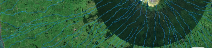
2.0 Tangata whenua overview
Tangata whenua kaitiaki
2.1   The rohe of Ngati Tāiri is a cultural landscape of importance. It was historically and in areas is still
      currently occupied and utilised to sustain our people and contains a wealth of occupation such as
      marae (meeting house), kāinga nohoanga (dwelling place), umu (oven), wāhi mahi kohātu (quarry
      sites), ara tawhito (traditional travel routes), māra (gardens), Tauranga waka (canoe landing sites),
      Tauranga ika (customary fishing grounds), mahinga kai (customary freshwater fishing grounds), wāhi
      pakanga (battle sites), pā (fortified villages) and urupā (n.b. this is a non-exhaustive list).

2.2   Today however, many sites have been destroyed by development and those that remain are in
      varying conditions of degradation. We seek to protect our values, cultural landscapes, waterbodies,
      ecology and remnant habitat for native species in our rohe from further inappropriate subdivision,
      use and development. With good development process it is possible to avoid, mitigate, remediate
      or offset adverse effects, restore habitat and ensure built environments reflect our values.

Kaitiakitanga
2.3   Through the relationship with ngā kaitiaki wairua, hapū have a duty or obligation to their ancestors,
      those living and future generations to come, to take care of, and protect places of cultural
      significance, natural resources and other taonga (collectively ngā taonga tuku iho – the treasures
      passed down) within their rohe. In former times, kaitiaki controlled and regulated access over
      natural resources within their rohe. Kaitiaki (an inherited role that included the guardianship of
      natural resources) were mandated by and on behalf of whanau, hapū and iwi to care for and protect
      the productive and spiritual well-being of ngā taonga. The duty of kaitiaki is to protect and
      strengthen both the intangible mauri and the physical well-being of the resource, place or taonga.

2.4   Kaitiaki carried out their responsibilities and obligations using kaitiakitanga - the responsibilities and
      customs used by kaitiaki to take care of ngā taonga tuku iho. This included a system of resource
      management practices, rules and techniques for managing natural resources which were both
      practical and spiritual in nature and included concepts such as tapu (sacredness) and rahui
      (temporary restrictions on use).

2.5   These kaitiaki obligations still exist today, they still have relevance and they are still practiced.
      Kaitiakitanga is carried out through the use of tikanga (customs), kawa (protocol) and mātauranga
      Māori (traditional knowledge) which have all been developed and passed down through the
      generations through waiata, karakia, and whakatauki as well as through oral tradition. The practices
      associated with kaitiakitanga are also closely linked with mana (status and pride) and tino
      rangatiratanga (self-determination).

Ngā Mahanga a Tāiri

2.6    For the purpose of this report the hapū refers to Ngati Tāiri only, the hapū with mana whenua over
       the land subject to this CIA assessment. However, Ngati Tairi and Nga Mahanga share a collective
       and are commonly referred to as Ngā Mahanga a Tāiri. The history of Nga Mahanga a Tāiri is
       detailed below.
                                         Te toka I tauria e te kukupara
                            (the small black mussel that adheres to the rock)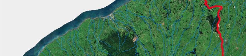
2.7    The whakataukī above is part of a saying handed down from about the middle of the sixteenth
       century. Te toka i tauria e te kukupara is a reminder that Ngā Mahanga a Tāiri have, do, and always
       will hold ahi kā for the area between Waiweranui and Waiwhakaiho Rivers.

2.8    Ngā Mahanga a Tāiri arrived in Taranaki in the early 10th century, where they moved inland to settle
       in the Ōkato District. In the 12th century, Ngā Mahanga a Tāiri formed an identify as two hapū, Ngā
       Mahanga and Ngāti Tāiri, with the latter moving into the Oākura area. Through inter-marriage with
       those already settled in the District, Ngā Mahanga ā Tāiri became the dominant iwi, so that by the
       15th century, their influence extended as far north as Ōhura.

2.9    Sharing close connections with hapū south of the Waiweranui River, Ngā Mahanga a Tāiri identifies
       with and works alongside Taranaki Iwi. Once an iwi in its own right, with the advent of war,
       confiscation and colonisation, it is now a hapū represented by two marae. Ngā Mahanga are based
       at Pūniho Pā - Tarawainuku Marae, south of Ōkato township. And Ngāti Tāiri reside just north of
       Oākura township at Ōkorotua Marae - Oākura Pā.

2.10   Today, Ngā Mahanga a Tāiri exercise mana whenua over an area bounded by the Waiweranui River
       and Ōnukutaipari (Paritutu), which includes Ngā Tīpuna Maunga of Kaitake, Pūkeiiti, Pouākai and
       part of Taranaki Mounga. Figure 1 shown below identifies the rohe of Ngā Mahanga ā Tāiri.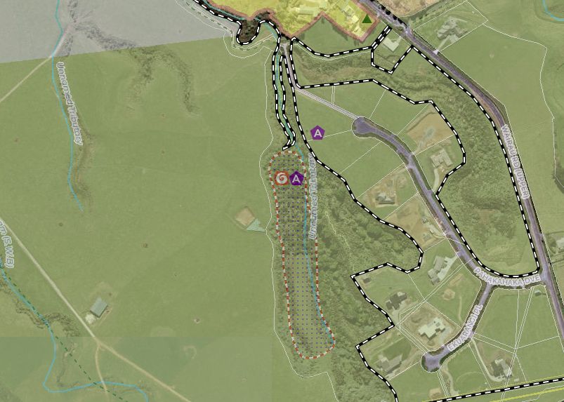
Figure 1: Ngā rohe o Ngā Mahanga me Ngāti Tāiri
3.0 Cultural Impact Assessment Objectives and purpose
Objectives
3.1 To:
document cultural values, interests and associations (including beliefs) of the specific area or
resource; and
identify the potential effects of the proposed activity on these; and
recommend methods to support (positive impacts), avoid, remedy or mitigate (adverse impacts)
those effects.
Purpose
3.2 To provide assistance to the Applicant and the New Plymouth District Council in meeting their statutory
obligations under the Resource Management Act 1991 (RMA).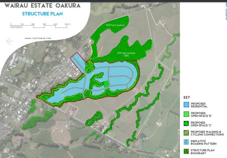
4.0 Proposal Description and summary
4.1 On the 5th of March 2018 the applicant, being Oākura Farm Park Limited applied for a private plan
change to the Operative New Plymouth District Plan. The application sought to rezone 58ha of land
on the southern side of Oākura from Rural Environment to a range of zonings including residential,
business, rural lifestyle and open space. The plan change request also sought the introduction of a
structure plan and new provisions to manage subdivision and development of this land.
4.2 The plan change was publicly notified for submissions and further submissions in late 2018. Council
received a total of 436 submissions and 38 further submissions.
4.3 One submission was lodged by Ngati Tāiri which raised the following:
The ecological effects from stormwater being disposed in waterways and the impact this would
have on existing habitats and ecosystems and their ability to exercise their kaitiakitanga;
That the design of the development incorporates cultural values; and
If the plan change proceeds that the development better manages stormwater runoff
addressing tangata whenua values.
4.4 A submission was lodged by Te Kāhui o Taranaki which opposed the proposal and raised the
following:
Taiao, Taiora the Taranaki Iwi Environmental Management Plan must be taken into account
when preparing and reviewing a plan change;
That any decision must take into account the relevant policies on ensuring subdivision and land
use are well designed and reflect cultural values;
Development that results in the degradation of mouri of Papatuanuku, or adverse effects on
Ranginui, Papatuanuku, ngā mounga o Taranaki, Tane, Tangaroa-ki-Tai and Tangaroa-ki-Uta is
not supported; and
Concerns on loss of access to sites of significance and adverse impacts on cultural values.
4.5 Five pre-hearing meetings occurred in January 2019. One specific meeting was between the hapū
and the Trust with the applicant at the Oākura Pā on the 29th of January 2019. As a result of this
meeting the applicant agreed to prepare an assessment of the application against Taiao, Taiora
the Taranaki Iwi Environmental Management Plan. The applicant also agreed to ensure an
archaeologist be on site during the earthworks phase of the development.
4.6 The Council reporting officer prepared a recommendation report recommending that the
application be approved in part limiting the yield of the proposal to 167 lots/dwellings.
4.7 A hearing commenced on the plan change in July 2019. On the 6th of September 2019 the
Independent Hearing Commissioner, Mr Bill Wasley issued a Commissioner Direction requiring
that further evidence be provided by the applicant on a number of issues including cultural effects.
As a result of this direction, the applicant has requested this CIA be prepared.
4.8 Further evidence was provided by the applicant on the 11th of October and this included a revised
proposal reducing the scale and nature of the requested plan change to a 144-lot residential plan
change. The revised version includes a structure plan to sit alongside the relevant planning
provisions.
4.9 The application (revised version) includes the following planning provisions to the Operative New
Plymouth District Plan which includes: The insertion of a specific policies being Policy 23.8 to ensure the subject site is
comprehensively planned for urban development; Policy 23.9 to provide for a safe and
efficient road transport network
Insert a Structure Plan that indicates a desired pattern of development by Environment Areas;
A rule requiring that the development and subdivision be in accordance with the Structure
Plan;
A rule requiring development and or subdivision within the Wairau Estate shall be subject to
timing restrictions for stages 2 – 5.
Rule specifying specific standards for Wairau Estate that relate to the following:
Maximum height of buildings and structure within the structure plan area of 6m;
Number of habitable buildings per allotment of one;
No coverage in the front yard for all Residential Environment Area sites;
Light reflectance values for roofs of 25% and other exterior claddings for structure and
buildings of no greater than 40%;
Covenants on Records of Title restricting building form in front yards and within landscape
buffers.
4.10 The revised Structure Plan as shown below in Figure 2, identifies Residential C and Open Space B
zoning.
4.11 The applicant has indicated in the revised application that development will be split across five
stages with timing controls on implementing each stage. Stage 1 can commence without time
restriction, with stage 2 not being able to begin until at least two years post approval of stage 1.
Following stage 2 approval, stages 3 – 5 can only sequential proceed following the sale of no less
than 75% of the lots in the preceding stage.
4.12 In addition to the information above, during the site visit associated with the preparation of this
CIA, the applicant also outlined that rural-residential sized allotments are proposed for the area
between SH45 and the 80m setback for residential uses from the road corridor. The applicant also
outlined their intention that all stormwater will flow to the tributaries of the Wairau Stream to
located in the centre and north of the structure plan area, and that a series of five bunds are to be
installed at various locations within the bed of these tributaries to manage the flow of water
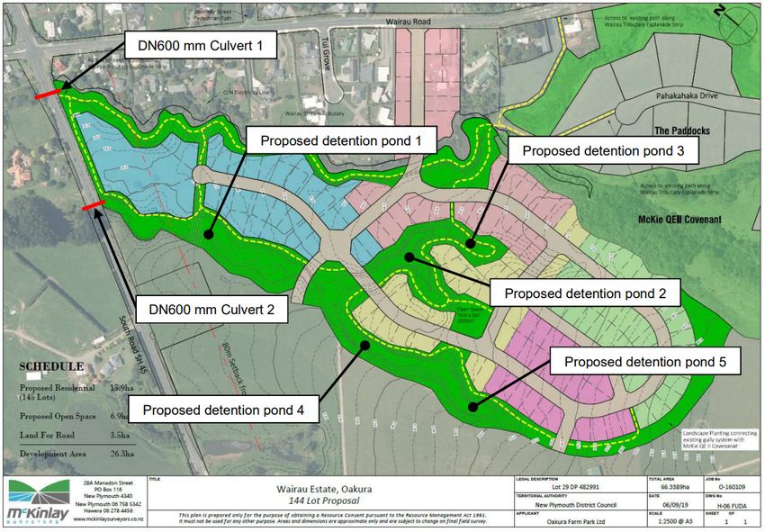
downstream. This is reflected in the updated engineering evidence provided on 11 October 2019.Figure 2: Proposed revised Wairau Estate Structure Plan
4.13 The further engineering evidence sets out where stormwater detention bunds up to three metres
tall within the tributaries of the Wairaiu are proposed. This is shown in figure 3 below.Figure 3: Proposed location of detention ponds within the tributaries of the Wairau stream
4.14 No specific provisions are included in the structure plan responding to submissions points made
by Ngati Tāiri or the Trust.5.0 Planning framework
Te Tiriti o Waitangi
5.1 The purpose of this CIA is to ensure that the spiritual and physical well-being of resources, area
and sites impacted by the proposed plan change are maintained, and that their kaitiaki obligations
are upheld. These roles and responsibilities apply to the ocean, rivers, lakes, forests, fisheries and
wildlife as they do to natural resources.
5.2 These resources were guaranteed to tangata whenua under Article 2 of the Treaty of Waitangi and
Te Tiriti o Waitangi (the Māori language version) for as long as tangata whenua so desired. Tangata
whenua have not relinquished these rights and responsibilities. Below is a transcript of the Second
Article of te Tiriti o Waitangi followed by the translation into English (Professor IH Kawharu) and
the first part of "Article the Second" of the Treaty of Waitangi.
"Ko te Kuini o Ingarani ka wakarite ka wakaae ki nga Rangatira ki nga Hapū, ki nga tangata katoa
o Nu Tirani te tino rangatiratanga o ratou wenua o ratu kainga me o ratou taonga katoa. Otiia ko
nga Rangatira o te wakaminenga me nga Rangatira katoa atu ka tuku ki te Kuini te hokonga o era
wāhi wenua e pai ai te tangata nona te Wenua - ki te ritenga o te utu e wakaritea ai e ratou ko te
kai hoko e meatia nei e te Kuini hei kai hoko mona."
"The Second The Queen of England agrees to protect the Chiefs, the subtribes and all the people of
New Zealand in the unqualified exercise of their chieftainship over their lands, villages and all their
treasures. But on the other hand the Chiefs of the Confederation and all the Chiefs will sell land to
the Queen at a price agreed to by the person owning it and by the person buying it (the latter being)
appointed by the Queen as her purchase agent." (trans. IH Kawharu)
"Her Majesty the Queen of England confirms and guarantees to the Chiefs and Tribes of New
Zealand and to the respective families and individuals thereof the full and exclusive and undisturbed
possession of their land and Estates, Forests, Fisheries and other properties which they may
collectively or individually possess so long as it is their wish and desire to retain the same in their
possession....."
Since the signing of the Treaty of Waitangi in 1840, land and other natural resources have been
gradually alienated from Tangata Whenua. This has diminished the authority of iwi, hapū and
whanau over ngā taonga tuku iho for which kaitiaki responsibilities were previously held. Despite
this loss, the tikanga, rights and responsibilities over natural resources by mana whenua, iwi, hapū
and whanau still remain strong.
Resource Management Act 1991
5.3 The Resource Management Act 1991 (RMA or the Act) further affirms both the guarantee set out
in Article 2 of the Treaty, as well as the rights and responsibilities of Tangata Whenua. In brief, the
purpose of the RMA is “the sustainable management of natural and physical resources”1 with the
Principle of the RMA (sections 6-8) requiring all persons exercising functions and powers under the
Act to:
recognise and provide for matters of national importance. These include the relationship
of Māori and their culture and traditions with their ancestral lands, water, sites, wāhi tapu
1
Part 2, Section 5, RMA 1991and other taonga2; and the protection of historic heritage from inappropriate subdivision,
use and development; and
have particular regard to other matters including kaitiakitanga, where this is defined in the
RMA as “the exercise of guardianship; and in relation to a resource, includes the ethics of
stewardship based on the nature of the resource itself”; as well as the maintenance and
enhancement of the quality of the environment; and
take into account the principles of the Treaty of Waitangi, noting that these principles of
the Treaty are not the same as the Treaty of Waitangi itself. These principles have been
developed from debate and case law over the exact meanings of the words and represent
a simplifications and summary of the basic concepts and agreements contained within the
two original documents, the Treaty of Waitangi and Te Tiriti o Waitangi. These principles
now appear in various New Zealand statutes and under the RMA is of particular
importance to tangata whenua in terms of resource management. The principles
considered to be most relevant in this instance include:
Retention of rangatiratanga: The Māori Chiefs looked to the Crown for protection from
other foreign powers, for peace and for law and order. They reposed their trust for
these things in the Crown believing that they retained their own rangatiratanga and
taonga.
Duty to Consult: The responsibility to act in good faith and reasonably puts the onus
on the Crown to make an informed decision, in many cases that will require
consultation.
Duty of active protection: The Crown has a duty to actively protect Māori interests in
the use of their lands and waters3.
Engaging the expertise of mana whenua to implement these obligations as they apply
in their rohe is fundamental in ensuring these provisions are met.
National Policy Statement for Freshwater Management 2014
Te Mana o te Wai
5.4 The National Policy Statement for Freshwater Management (NPS-FM) recognises that fresh water
has a deep cultural meaning to Aotearoa. Te Mana o te Wai is a concept described with the NPS-
FM; and recognises that each water body has its own mauri and its own mana which must come
first to protect the integrity of the water body. Upholding Te Mana o te Wai requires provision for
Te Hauora o te Taiao (the health of the environment), Te Hauora o te Wai (the health of the
waterbody, and Te Hauora o te Tangata (the health of the people).
5.5 The NPS-FM includes clear direction regarding the concept of Te Mana o te Wai and its
consideration through resource management process. Importantly for this application, this
includes consideration of integrated management of freshwater resources by all local authorities.
This includes ensuring tangata whenua rights and interests are reflected in freshwater
management.
2
Case law has defined that ‘ancestral lands’ do not have to be in Māori ownership; however the Court of Appeal
found that councils and courts should base resource management decision on the well-being of the community as
a whole even if that was at the expense of a segment of the community, including Māori.
3
The Treaty of Waitangi is a living document to be interpreted in a contemporary setting. New principles are
constantly emerging and existing ones are modified. However, the key principles of the Treaty of Waitangi were
outlined by the Court of Appeal in New Zealand Māori Council v Attorney-General [1987] 1 NZLR 641.5.6 The application site is located within the Wairau catchment. In the opinion of tangata whenua this
catchment is severely degraded, with a number of threats to water quality, quantity and use
elevated in the Wairau due to the level of development within its catchment.
5.7 The proposed NPS-FM 2019 elevates Mahinga Kai as a compulsory value to be considered in the
management of freshwater, alongside others, to inform the target to maintain or improve the
health of a waterbody.
The Regional Freshwater Plan for Taranaki
5.8 The Regional Freshwater Plan for Taranaki (RFWP) contains a number of provisions relevant to the
application, mainly for the construction phase, and the management of stormwater. Consent will
be likely for the earthworks in the construction phase of the proposal due to the size of the area
to be active. This is pursuant to rule 27 of the RFWP (fully discretionary).
The Operative New Plymouth District Plan 2005
5.9 The Operative New Plymouth District Plan (NPDP) is relevant to this application as the private plan
change seeks to sit within the Operative District Plan and use the existing provisions in the District
Plan to enable the development.
5.10 The current Operative District Plan does not identify or map the Pā site on the subject site as wāhi
tapu and therefore does have any protection under this plan. Given there are no wāhi tapu sites
or sites of significance to Māori mapped on the subject site or adjacent land no relevant cultural
value consideration will be given to development on the proposed site. Therefore, the provisions
of relevance to this development relate primarily to the Residential C Environment Area provisions
and the Open Space provisions, particularly the Residential C provisions as it will be this zoning that
will trigger resource consents through both subdivision and development on the proposed subject
site.
5.11 Given the effects-based nature of the Operative District Plan, no activities are excluded from
occurring the Residential C Environment Area. By way of summary the Residential C Environment
Area provisions provides for a number of bulk and location provisions, all which non-compliance
defaults to a restricted discretionary activity. These are summarised as:
Maximum height of 9m for buildings;
Height in relation to boundary provisions in relation to side boundaries and road boundaries;
Front yard coverage of 35% (proposed Plan Change area proposed to be exempt from this
provision);
Site coverage of 35%;
Setback from a side boundary of 1.5m;
Maximum length of a building of 30m within 10m of side boundary; and
Minimum allotment size for subdivision of 700m².
5.12 The matters over which the Council has restricted its discretion primarily relates to amenity and
visual effects. There are no relevant assessment criteria for considering cultural views or potential
effects. Subdivision in the Residential C Environment area requires a minimum lot size of 700m²,
with any subdivision creating a road being subject to a fully discretionary resource consent
application. The subdivision assessment criteria do provide the below relevant criteria to
considering cultural values and effects:
15) The extent to which the proposal has regard to Māori values, particularly any traditional,
cultural, or spiritual aspect relating to the land.5.13 This one assessment criteria in the Operative District Plan is the only relevant matter to considering
and assessing cultural values and effects resulting from a proposed subdivision in the Residential
C Environment Area, given the absence of a wāhi tapu site to trigger assessment under those
provisions of the Plan.
Proposed New Plymouth District Plan (September 2019)
5.14 The Proposed Plan was notified on the 23rd of September 2019 and is open for submissions until
the 22 November 2019. At the time of writing this, the Proposed Plan was still open for submission
and is therefore still within an early phase of notification.
5.15 The Proposed Plan identifies the site as containing a Pā site, being Pahakahaka Pā, which is listed
as a both a Site of Significance to Māori (SASM) (Site ID 2261) and an archaeological site. This site
is mapped in the District Plan maps as shown in Figure 3 below.
Figure 4: Aerial photo of the portion of the subject site showing the extent of SASM 2261 in the proposed
plan
5.16 The rules associated with this site now have immediate legal effect as per Section 86B (3) (d) of
the RMA. This means any development on the site would be required to meet the provisions of
this Plan. The site also contains the Wairau Stream (a significant waterbody) and tributaries of this
stream, provisions associated with waterbodies also have immediate legal effect. The relevant
provisions to the subject site that have immediate legal effect are:
Sites of Significance to Maori (SASM)
SASM – R5: Erection of a structure within 50m of a scheduled site or area of significance
to Maori;
SAM-R6: Additions to a structure on or within 50m of a scheduled site or area of
significance to Maori;
SASM-R8: Earthworks on or within 50m of a scheduled site or area of significance to Maori;
SASM-R9: Subdivision of land that contains any part of a scheduled site or area of
significance to Maori.Archaeological sites
HH-R14: Erection of a structure on or within 50m of a scheduled archaeological site;
HH-R15: Additions to a structure on or within 50m of a scheduled archaeological site;
HH-R16: Relocation of a structure onto or within 50m of a scheduled archaeological site;
HH-R17: Earthworks on or within 50m of a scheduled archaeological site;
HH-R18: Subdivision of land containing any part of an archaeological site.
Waterbodies
WB-R1: Erection of a building on a site containing or adjoining a natural waterbody or
significant waterbody;
WB-R2: Relocation of a building onto a site containing or adjoining a natural waterbody or
significant waterbody;
WB-R3: Addition to a building on a site containing or adjoining a natural waterbody or
significant waterbody;
WB-R4: Earthworks on a site containing or adjoining a natural waterbody or significant
waterbody;
WB-R5: Subdivision of land containing or adjoining a waterbody;
WB-R6: Subdivision of land containing or adjoining a significant waterbody;
WB-R7: Wastewater treatment plant on a site containing or adjoining a natural waterbody
or significant waterbody.
5.17 The site also contains site 2530, an archaeological site identified as a fire feature. This site is on the
southern National Park boundary and is well setback from the Plan Change boundary.
5.18 The site contains the Wairau Stream and its tributaries. A public access corridor along the Wairau
Stream is provided. The Proposed Plan provides provisions around erecting structures and
subdividing on land that contains a public access corridor. The Plan Change boundary is setback
from the Wairau Stream and is not within the area subject to rezoning and will be retained on the
balance rural land. However, Rule WB-R6 listed above will apply to the first subdivision that
separates the balance land from the plan change area. The Plan Change does include tributaries of
the Wairau Stream, but these are not listed significant waterbodies in the Proposed District Plan.
Rule WB-R5 will apply to any subdivision including waterbodies and requires controlled activity
consideration around values and flooding or erosion.
5.19 The application of these rules will be subject to a weighting exercise at time of consent until such
time as the Proposed Plan becomes operative, which may be some years away.
5.20 The applicant proposes to apply the General Residential provisions proposed in this plan to the
proposed Residential Area identified in the structure plan. The Operative District Plan is a hybrid
between an effect based and activities-based plan. This means it list activities that are not suitable
within the General Residential Zone, these are:
Restricted Discretionary Activities:
Multi-unit developments;
Retirement village;
Child-care services; and
Community facilities.
Discretionary Activities: General retail activities;
Supermarkets;
Entertainment and hospitality activities; and
Sport and recreation activities.
Non-Complying Activities:
Industrial activities;
Primary production;
Rural industry activities;
Commercial service activities; and
Large format retail activities.
5.21 The effects standard provides bulk and location provisions for buildings these are summarised as:
Maximum number of residential units as two or one residential unit and one minor or one
sleep-out;
Building height of 8m;
Maximum site coverage for all buildings except papakainga of 40%;
Height in relation to boundary provisions to the side and road boundaries;
Building length of 30m within 10m of a side boundary;
Building setbacks of 3m from a road boundary;
Building setbacks of 1.5m from a side boundary;
A 50m² outdoor living space;
A minimum separation between residential units of 3m;
A minimum 25% landscaped permeable surface area;
Accessory buildings (including garages) must not project more than 0.5m beyond
residential unit; and
Fences within a front yard shall not exceed 1.4m in height and on a side boundary of 2m
in height
5.22 The Proposed Plan includes a number of relevant objectives and policies that requires
development and applicant to consider, acknowledge and protect cultural values and sites of
significance to Maori. These objectives and policies are set out in Objectives SASM 01 – SASM 03,
and the directive policies are SASM – P1 to SASM – P8. Relevant objectives and policies to address
cultural values are also incorporated throughout the plan and are evident in the waterbodies and
Residential chapters.
Taiao, Taiora – An Iwi Environmental Management Plan for the Taranaki Iwi Rohe
5.23 Taiao, Taiora is an Iwi Environmental Management Plan for Taranaki Iwi Rohe. This document is
required to be taken into account through resource management process, including the
consideration of plan changes. This iwi planning document contains a number of directive policies
relevant to the proposal. These include:
Manage development so that it does not adversely affect Ranginui, Papatuanuku, Taranaki
Mounga, Tane, Tangaroa-ki-Uta and Tangaroa-ki-Tai;
New development should be designed in a way that reflect environmental and cultural values;
Landscape assessment will consider cultural values as an important and inseparable part of
that landscape; Subdivision and development should not adversely impact cultural values associated with
landscapes of importance to Taranaki iwi (hapū/ marae/pā).
Promote and support access to water for the social, cultural, economic and environmental
values of Taranaki Iwi;
Taranaki iwi will not support residential development within 5km of the National Park
boundaries; and
Taranaki iwi will support the extension of the endemic habitat of the national park that assist
with its proliferation to enhance natural values associated with the mounga.
5.24 These policies are supported by the identification of key issues and set of clear directive objectives.
Summary
5.25 The Treaty of Waitangi/Te Tiriti o Waitangi 1840, particularly Article 2, conferred on tangata
whenua a right in respect of full exclusive and undisturbed possession of their lands and estates,
forests, fisheries and other properties/taonga. The RMA, regional and district planning documents,
and tangata whenua management plans, are amongst the legislation, policies and statements that
affirm the mana whenua status of tangata whenua. The role of kaitiaki in regard to the
management and monitoring is affirmed as is the relevance and practice of kaitiakitanga.6.0 Tangata whenua associations/values
Receiving environment
6.1 The application site is located within the rohe of Ngati Tāiri. Today, the landscape is made up of rolling
pastureland, dissected by and bounded by the Wairau Stream and its tributaries. The land slowing rises
up the south towards the Kaitake Ranges.
6.2 The site is located on Kaitake (albeit outside of Egmont National Park) and includes Pahakahaka Pā
located within the land identified as the ‘McKie QEII Covenant’ area. It is relevant to note that during
the construction of the Paddocks subdivision other previously un-recorded sites were located and
documented. It is estimated that Pahakahaka Pā was home to approximately 200 people. It is therefore
reasonable to expect that the land subject to the plan change may be home to further un-recorded
cultural sites given the proximity of the development to the Pā.
6.3 The wider receiving environment includes an area that previously heavily occupied by Māori and is of
immense cultural importance to the hapū and Taranaki Iwi.
6.4 The bond between the tangata whenua and Kaitake are inseparable and are fundamental to the
foundation of Ngati Tāiri and Taranaki Iwi. These bonds are also expressed through cultural practices
and art forms evolved from generations of occupation. Tangata whenua draw strength from the energy
of Kaitake; the flora and fauna that was abundant from the slopes to the sea which allowed Ngati Tāiri
prosper and flourish. Ms Wano-Bryant’s submission on the Plan Change provided this important
whakatauki:
‘Ko Taranaki, ko Pouākai, ko Kaitake, koia te puna i heke mai ai te tangata. Koia ko ō mātou
nei okiokinga, ko mātou nei tō rātou okiokitanga’
‘Taranaki, Pouākai and Kaitake are a reflection of and the source of our inseparable
existence, in life and in death. We are them and they are us’
6.5 The values of the Kaitake are not just visual as they provide a broad range of cultural values and this
surrounding landscape was one of large occupation as is evident by Pahakahaka Pā.
Te Ao Māori – Māori world view
6.6 As Māori, Ngati Tāiri and Taranaki Iwi have a holistic view of the environment based around whakapapa
(genealogy) and whanaungatanga (relationships), connecting us and all physical and spiritual things in
the world. Our relationship with the environment stems from our whakapapa to Papatūānuku (Earth
Mother) and Ranginui (Sky Father) who gave rise to many children, also known as the Atua (guardians)
of the domains of the natural world. Therefore, it is important to understand that potential impacts of
any proposed activity would be conceptualised holistically. For example, we would not consider
environmental impacts separately to impacts on our health and wellbeing.
6.7 Over the last 200 years the prominence of the Māori worldview has been eroded across the political
landscape of Aotearoa/ New Zealand. This began with the denigration of Rangi, Papa and the other
Atua with the arrival of the early Christian missionaries. This continued with the gradual loss of control
by tangata whenua over land and other resources. The strengthening of the Western Worldview’s
focus over this time on the individual and his material needs has further eroded the values inherent in
the Māori Worldview. It is of no coincidence that over this time the condition of natural resources has
generally degraded and the amount available for use have diminished. The reversal of this trend bothin the condition of natural resources and the relevance of Te Ao Māori is most welcomed by tangata
whenua.
Mātauranga – Knowledge systems
6.8 Mātauranga can be described as “the pursuit and application of knowledge and understanding of Te
Taiao, following a systematic methodology based on evidence, incorporating culture, values and world
view”. It draws on the knowledge of our ancestors, contributes to present day knowledge, and passes
on to our future generations. It is dynamic and has the ability to adapt and respond to all situations.
Mātauranga is intergeneration and is passed down through whakapapa, waiata (song), haka (war
dance), whakataukī (proverbs), pūrākau (legends), kōrero tuku iho (ancestral stories), or whakairo
(carvings). Some of our mātauranga is described below as the rationale for our cultural values.
6.9 Through these concepts of Te Ao Māori and mātauranga, we have developed the following cultural
values which are the basis from which we inform our decision-making processes, to sustain and
enhance our environment and its resources.
Nagti Tāiri Cultural Values Assessment
6.10 Ngati Tāiri have developed a cultural assessment framework to assess the proposal against; this is set
out in the table below:Ngā Mahanga a Tāiri Cultural Assessment Framework
Principles Whakamārama Whakataukī Desired Outcomes
Mana whenua is the principle that defines Ngā Mahanga a Tāiri through lands
occupied by right of ancestral claim. It defines the places where we are intimately Te toka i tauria
E te kukupara Ngā Mahanga a Tāiri maintains a unique
connected, where we belong, where we can “be” and where we call “home”.
Mana relationship with those parts of Ngā Kāhui
Essential to Ngā Mahanga a Tāiri well-being, these lands and places are where we Like the small black mussel
Whenua Mounga, their waters and surrounding
find ourselves, our strength, our inspiration, our mana. Firmly grounded in the land, That clings tenaciously to the rocks. landscapes, which fall within our rohe.
we enjoy a secure sense of identity and cultural integrity, and are proud and
confident in all walks of life.
Ko te whenua, te kiko,
Mana tiaki describes our role as guardians of the land, for the benefit of future Ko ngā wai, te toto,
Ngā Mahanga a Tāiri as Kaitiaki ensures
generations. Intimately entwined with our history, culture and heritage, by actively Ko te maunga, te tupuna
the sustainable use and management of
protecting and preserving this land, our ahi kā continues to burn brightly. Likewise, Ko tēnei te tūrangawaewae.
Mana Tiaki it is our responsibility to ensure that people are culturally safe while upon our lands.
Ngā Kāhui Maunga, their waters and
We know these lands, surrounding landscape for future
In doing so, we draw on the deeds and practices of our ancestors, a source of
And these lands know us, generations.
inspiration and motivation for Ngā Mahanga a Tāiri, now and into the future.
We are in every blade of grass.
Mākū anā hei hanga i tōku nei whare,
Mana motuhake is the right to determine the best course of action, which will
Ko ngā pou o roto, he māhoe, he patatē,
progress towards, or actually achieve the outcomes most valued by Ngā Mahanga a
Ko te tāhuhu, he hīnau. Ngā Mahanga a Tāiri exercises the right to
Tāiri. The principle is commonly expressed as self-autonomy, self-determination and
Mana make its own decisions, which best
exercising choice in a range of contexts and settings. Mana motuhake also implies I shall fashion my own house,
Motuhake contribute to, or actually achieve its long-
an understanding of our diverse realities, needs and priorities, as well as an The poles within will be made
term goals and aspirations.
expectation that we will be engaged, involved, resourced and consulted where Of māhoe and patatē,
appropriate. And the ridge pole made of hīnau.
Mana tiriti refers to the following key principles that guide engagement and
consultation with Ngā Mahanga a Tāiri:
1. Tino rangatiratanga: Ngā Mahanga a Tāiri retains its tino rangatiratanga, i.e., the Kahore i hangaia te kupenga,
right to manage the full extent of our affairs according to tikanga; Hei hopu ika anake,
Engari kia oioi
2. Reciprocity and mutual benefit: Proposals must provide a basis for considering Ngā Mahanga a Tāiri values relationships
I roto i te nekeneke i te tai.
mutual benefits to both or all parties; based on Treaty of Waitangi principles,
Mana Tiriti 3. Partnership: Relationships with Ngā Mahanga a Tāiri are typified by on-going For the net is fashioned which contribute to, or actually achieve
negotiation and dialogue, and do not affect the hapū in acting on its own behalf; Not only to catch fish, outcomes of mutual benefit.
4. Options: Ngā Mahanga a Tāiri reserves the right to identify options, which align to but to flow smoothly,
its aspirations, outcomes and priorities. With the current of the sea.
5. Equity: Ngā Mahanga a Tāiri expects its interest to be considered equally, and not
at the expense of others.6.11This table sets out the hapū cultural values into four principles, these are:
Mana whenua;
Mana tiaki;
Mana motuhake; and
Mana tiriti.
6.12 These key principles help identify desired outcomes Ngati Tāiri require in order to protect their
cultural values, these outcomes are summarised in the table above.7.0 Assessment of proposed Plan Change on tangata whenua values
Introduction and scope
7.1 The application site sits within a cultural landscape that is significant to both Ngati Tāiri and Taranaki
Iwi. As outlined in Taiao, Taiora – in general residential development within proximity to the
national park will not be supported. If the Commission was of a mind recommend granting of the
proposal, provisions which go substantially beyond those of the General Residential/Residential C
Environment Area would be required to manage subdivision, use and development as these impact
on our cultural landscape and cultural values associated with this land being mana whenua, mana
tiaki, mana motuhake and mana tiriti . Provisions must not only manage the change of landuse from
rural to urban, but also the on-going change in this location over time that will occur as the
community expands, and the physical environment is modified in the short, medium and longer
term.
7.2 Ngati Tāiri and Taranaki Iwi have observed where ‘standard’ provisions have been relied upon to
manage the impact of urban growth in significant cultural landscapes elsewhere in the District, and
the destruction of the relationship mana whenua are able to have with their ancestral lands, water,
sites, wāhi tapu, and other taonga that has resulted. This position was set from early engagement
with this application and remains till now.
7.3 This assessment of the proposal on tangata whenua values resulting from the application is made
in light of the RMA process, particularly s.32 and Schedule 1 of the RMA. This CIA has been made
cognisant of the information provided in the expert assessments provided by the applicant, the
Council, and those of submitters in respect of the proposal.
7.4 In this instance Ngati Tāiri and the Trust have had a truncated period of time since this CIA was
commissioned with which to undertake this CIA process, noting the revised application and revised
expert reports.
7.5 In our view this should have been required as a matter of priority when the original application was
made; and the expert cultural advice commissioned at that time to inform the plan change process,
the development of the proposal and associated technical reports, and recommendations made to
the commission to date. Providing this expert advice at the end of the hearing process, as opposed
to through the development of the proposed plan change, or to inform the reporting planner in
relation to the potential effects of the proposal has made the assessment and management of
potential cultural effects difficult. Ngati Tāiri and the Trust believe that cultural values and potential
cultural effects may have been more adequately addressed had this CIA process and cultural expert
advice been sought at the inception of this plan change process.
7.6 The cultural landscape, which includes the subject site is significant to Ngati Tāiri. This landscape
goes much further than the physical and tangible "things" and covers:
biodiversity-conservation remediation, enhancement and long-term environmental
sustainability social benefits derived from the cultural weight of the landscape, and sense of
place;
the retention of aesthetic, historic and traditional values;
ensuring long-term site access for tangata whenua; scientific benefits which holds not only material but also traditional information relevant to
indigenous, historic and anthropological research; and
symbolism - for example, heritage ownership and "identity".
7.7 As outlined in submissions, and evidence presented through the hearing process key areas of
concern to both iwi and hapū are:
The proximity of development to Kaitake, and the ability to avoid, remedy or mitigate
adverse effects on the relationship of mana whenua with Kaitake.
The proximity of the development to Pahakahaka Pā, and the potential for the
development to impact on previously un-recorded sites around the pā;
The increased visibility and access to the Pā which will result from the development and
may result in degradation of the site;
The absence of the identification and recognition of an important wāhi taonga to hapū
within the application and its relevant plans (including objectives, policies, rules and
identification on planning maps);
The management of earthworks within the development area;
The management of stormwater run-off created as a result of the development, and the
impact that this will have on the waterbodies within the subdivision;
The proposed mechanisms for ensuring planting, access and other commitments made are
achieved through the current structure plan provisions;
The proposed mechanisms for ensuring adequate ongoing consultation and engagement
with tangata whenua as the development continues, including mechanisms that ensure
cultural expertise would continue to guide the development; and
The proposed mechanisms to kōrero the importance of the site and surrounding
environment to tangata whenua, including with people who subsequently live in proximity
should the plan change and subdivision proceed.
Impact on Kaitake
7.8 Kaitake is of cultural significance to both the hapū and iwi. As set out in submissions, Kaitake is not
contained solely to the boundaries of Egmont National Park; a common misconception. This
misconception appears to have continued to prevail in the landscape assessment work completed
to date, where revised landscape assessments have not considered this fact as a part of that expert
advice. As a result, there are no specific provisions identified in the structure plan which recognise
and provide for the relationship Ngati Tāiri and Taranaki Iwi hold with Kaitake, which as noted in
submissions is significantly more than just visual effects.
7.9 During the site visit undertaken as a part of this CIA discussions were held regarding the potential
for biodiversity corridors (including predator control), restoration planting along waterbodies, and
design standards for any subsequent buildings. It is not clear how these considerations would be
triggered under the current proposal, noting the limited scope of existing rules of the operative
plan to consider these matters, or the guidance of specific objectives or policies in the structure
plan requiring these outcomes to be implemented.
7.10 Urban development within this cultural landscape will degrade the cultural values outlined above,
namely mana tiaki though urbanisation and development.
7.11 Landscape effects, and the ability to avoid, remedy or mitigate the adverse effects of the proposal
on the relationship mana whenua have with Kaitake is an issue that this CIA process to date hasbeen unable to reach a conclusion, and therefore a precautionary approach must be taken with
regard to these effects.
Pahakahaka Pā
7.12 The subject site (being the certificate of title subject to the plan change) includes the Pahakahaka
Pā. The Pā site is located within the area of bush remnant directly adjacent to the proposed
residential area identified on the proposed structure plan. The proposed structure plan
provisions, and associated evidence repeatedly assert that the site is clear of sites and areas of
significance to Māori. Ngati Tāiri and the Trust consider the archaeological record as it relates to
the structure plan area to be incomplete, and stress that in the absence of that information a
precautionary approach must be taken.
7.13 The structure plan refers to the area as the McKie QEII covenant area and does not acknowledge
or identify the Pā. The application, including a number of pieces of evidence presented by the
applicant states that the site does not include any sites of cultural or archaeological importance.
In fact, the subject site includes this Pā site and the proposed residential zoned areas will directly
adjoin this Pā site. As observed through the development of the Paddocks subdivision further
peripheral archaeological features associated with Pahakahaka were found, and it is reasonable
to expect that this would be the same within the application site.
7.14 It is considered that this site, along with others found during the development of the Paddocks
subdivision are important context the proposed structure plan is located within. As the structure
plan, and associated provisions are silent on the site, it is evident that the proposal has not
considered this feature in the design of the proposal, nor recommended provisions by which any
subsequent subdivision and landuse will recognise and protect this area of historic heritage over
time in the revised proposal under consideration. This Pā is of significant cultural importance to
Ngati Tāiri and it is considered important that the proposed plan change acknowledges, identifies
and protects this site.
7.15 The current Operative District Plan offers no protection of the site. The Proposed District Plan
identifies and protects activities occurring within and adjacent to this site; however as noted
above, provisions of the proposed plan are subject to a weighting exercise through the consent
process until such time as the proposed plan becomes operative. With this ambiguity it is not
considered that provisions of the proposed plan are sufficient to manage the proposal in relation
to historic heritage4.
7.16 Ngati Tāiri consider that the application must go further in recognising and providing for this site
of significance and should the Commission be of a mind to recommend approval of the
application, it is recommended the following provisions as a minimum are included:
Identification and acknowledgement of the Pā site on the structure plan and planning
maps;
Specific provisions that sets the outcome for the development of the structure plan in
relation to Pahakahaka and any peripheral features, and manages this through the
4
Recognition and protection of this taonga is also consistent with provisions set out in Taiao, Taiora, and
required under the RMA (s.6(f)) as a matter of national importance. Without recognising and providing for this
the application cannot give effect to Part two of the RMA.subdivision, landuse and into other regulatory mechanisms (e.g. Reserve Management
plans) are required. It is expected that these provisions would govern any subsequent
resource management process.
A revised structure plan to ensure there is a building setback from the Pā to protect the
site from further degradation; and
The structure plan be amended to ensure that the Pā site adjoins a reserve area to allow
active public surveillance of the site.
There are further issues in relation to ensuring any person living in proximity to Pahakahaka
knows and respects the importance of the area, as well as the on-going management of the area
that we are unable to resolve.
Earthworks
7.17 The applicant has outlined that the plan change design has been to ensure minimal earthwork is
required, and that the existing landform will be retained where practicable. Ngati Tāiri support
this, particularly the retention of the existing landform.
7.18 The applicant in evidence by Mr Bruce, acknowledges the potential for discovering sites of
archaeological importance. Given the proposed plan changes location and proximity to a Pā site it
is considered reasonable that further cultural sites or features may be discovered when
earthworks occur. The applicant has stated that they will obtain an archaeological authority under
the Heritage New Zealand Pouhere Taonga Act 2014 (HNZPT). Damage to, or destruction of
important historical records of human occupation whether middens, artefacts, structures, and
other cultural material and the like results in both a spiritual and physical loss to tangata whenua.
7.19 The application proposes to manage these effects through the use of an Discovery Protocol
implemented under the guidance of a hapū monitor on site. Hapū support this approach but stress
that an adaptive management approach must be taken in this instance, with the design of any use
or development being undertaken once the archaeological record for the application site is more
complete. To date archaeological survey has been limited to surface observation. It is not clear
how these requirements will be carried through to resource consent conditions with no specific
provisions identified in the plan change to address this. The Proposed District Plan provisions
provide earthworks provisions associated with any earthworks within 50m of the extent of the
Pahakahaka Pā but would not extend to the rest of the application site at this point in time.
7.20 Recognising previously un-recorded features in the design of the subdivision and providing a
provision that enables this is required. This could be achieved through the commissioning of
further archaeological assessment, and the initiation of a Kaitiaki Forum resourced by the consent
holder.
7.21 Earthwork has the potential to create sediment run off into waterbodies and it is considered a
construction management plan will be necessary to manage sediment run off through silt fencing
and bunding and the like. Hapū would expect that the Construction Management Plan is certified
by hapū prior to any site works commencing.
7.22 Should the Commission be of a mind to recommend approval of the plan change the hapū require
that:You can also read