West Musgrave Copper and Nickel Project Groundwater Monitoring and Management Plan - EPA WA
←
→
Page content transcription
If your browser does not render page correctly, please read the page content below

West Musgrave Copper and Nickel Project
September 2021

Groundwater Monitoring and Management Plan

West Musgrave Copper and Nickel Project
                                        Groundwater Monitoring and Management Plan

VERSION CONTROL

 Revision        Version          Authorisation       Position                   Signature   Date

                                                      Environment and
                                  Justin Rowntree     Approvals Lead –                         01/06/2021
                                                      West Musgrave
                  Final
     -                                                General Manager –
                For Initial       Michael Wood                                                 01/06/2021
                                                      West Musgrave
                Approval

                                                      Acting Chief Commercial
                                  Matt Reed                                                    01/06/2021
                                                      Officer – OZ Minerals

                                                      Sustainability Manager –
                                  Justin Rowntree                                              01/09/2021
                                                      West Musgrave

                                                      Approvals Manager –
                   Final          Daniel Leinfelder                                            01/09/2021
                                                      West Musgrave
                 For Initial
     1
                 Approval
              (RFI Response)                          Operations Executive –
                                  Matt Reed                                                    02/09/2021
                                                      OZ Minerals

                                                      Projects Executive –
                                  Mark Irwin                                                   02/09/2021
                                                      OZ Minerals

West Musgrave Project   /   Groundwater Monitoring and Management Plan                       Page 2 of 53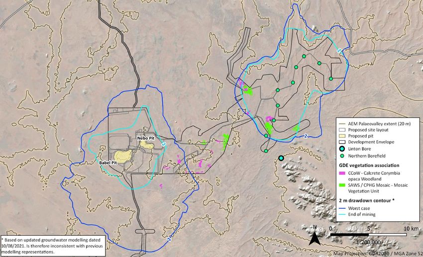
West Musgrave Copper and Nickel Project
                                        Groundwater Monitoring and Management Plan

DISCLAIMER

This Management Plan and associated appendices for the West Musgrave Copper and Nickel Project
(Document) has been prepared for submission to the Government of Western Australia’s Environmental
Protection Authority acting on behalf of the Minister for the Environment under the Environmental
Protection Act, 1986 (WA) and no one other than the Minister, or their delegate, should rely on the
information contained in this Document to make, or refrain from making, any decision.
In preparing this Document, OZ Minerals Limited (OZ Minerals) has relied on information provided by
specialist consultants, government agencies and other third parties. OZ Minerals has not fully verified
the accuracy or completeness of that information, except where expressly acknowledged in this
Document.
This Document has been prepared for information purposes only and, to the full extent permitted by
law, OZ Minerals, in respect of all persons other than the Western Australian Minister for the
Environment, or their delegate:
•   Makes no representation and gives no warranty or undertaking, express or implied, in respect to the
    information contained herein; and
•   Does not accept responsibility and is not liable for any loss or liability whatsoever arising as a result
    of any person acting, or refraining from acting, on any information contained in this Document.

NOTE ON CURRENCY
Where possible, information contained in this Document is up to date as at September 2021. This was
not possible for all supporting appendices, and information based on those appendices, which were
prepared by third parties (as discussed in the second paragraph in the Disclaimer above) prior to the
Document being finalised.

COPYRIGHT

Copyright © OZ Minerals Limited, 2021
All rights reserved

This Document and any related documentation is protected by copyright owned by OZ Minerals Limited.
Use or copying of this Document or any related documentation, (with the exception of that required by
law) in whole or in part, without the written permission of OZ Minerals Limited constitutes an
infringement of its copyright.

West Musgrave Project   /   Groundwater Monitoring and Management Plan                            Page 3 of 53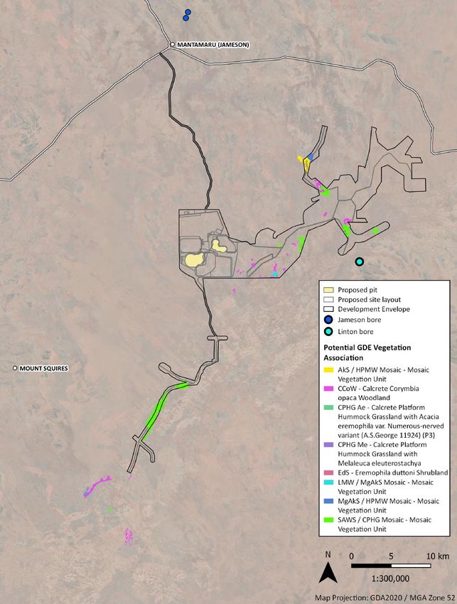
West Musgrave Copper and Nickel Project
                                        Groundwater Monitoring and Management Plan

SUMMARY
A summary of the key Environmental Management Plan (EMP) information is presented in Table 1.

Table 1: Summary of Key EMP Information

 Project Information                   Description

 Proposal Title                        West Musgrave Copper and Nickel Project

 Proponent Name                        OZ Minerals

                                       The Proposal is currently being assessed by the Government of Western
                                       Australia’s Environmental Protection Authority (EPA). The EPA has proposed
 Ministerial Statement No/s and        that a Groundwater Monitoring and Management Plan (GMMP) will be a
 Condition/Clauses                     condition of approval of the proposed project.
                                       A Ministerial Statement and associated conditions are yet to be issued.
                                       To provide a management framework for groundwater, specifically to avoid,
                                       where possible, otherwise minimise direct and indirect impacts to
 Purpose of the EMP
                                       groundwater dependant ecosystems and beneficial users resulting from the
                                       implementation of the West Musgrave Project.
 Key Environmental Factor              Inland Waters
 Objective (as relevant to this        To maintain the hydrological regimes and quality of groundwater…so that
 management plan)                      environmental values are protected
 Key Provisions of the EMP              See Section 2

 Proposed Construction Timing          Commencing 2022, progressing to 2024

 EMP Required Pre-construction?        Yes, prior to issuing of Ministerial Statement

 Proposed Operations Timing            26 years from date of commissioning

West Musgrave Project   /   Groundwater Monitoring and Management Plan                                   Page 4 of 53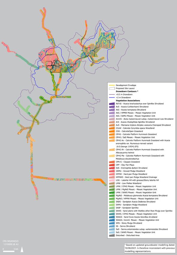
West Musgrave Copper and Nickel Project
                                                           Groundwater Monitoring and Management Plan

TABLE OF CONTENTS

1         CONTEXT, SCOPE AND RATIONALE ...................................................................................................................7
          1.1        Proposal .................................................................................................................................................................................. 7
          1.2        Key Environmental Factor ............................................................................................................................................ 11
          1.3        Condition Requirements............................................................................................................................................... 13
          1.4        Rationale and Approach ............................................................................................................................................... 13

2         MANAGEMENT OUTCOMES ............................................................................................................................... 31
          2.1        Environmental Criteria ................................................................................................................................................... 31
          2.2        Monitoring.......................................................................................................................................................................... 31
          2.3        Proposed Vegetation Health Assessment ............................................................................................................. 35
          2.4        Implementation of Trigger Criteria Actions.......................................................................................................... 37
          2.5        Implementation of Threshold Criteria Contingency Actions......................................................................... 37
          2.6        Reporting ............................................................................................................................................................................ 37

3         ADAPTIVE MANAGEMENT................................................................................................................................... 39
          3.1        Management Plan Review ........................................................................................................................................... 40

4         STAKEHOLDER CONSULTATION ....................................................................................................................... 41

5         UPDATES TO THE EMP .......................................................................................................................................... 42

6         REFERENCES .............................................................................................................................................................. 43

List of Appendices

Appendix A            GDE Assessment Review ......................................................................................................................... 45

Appendix B            Vegetation Health Monitoring Guidelines....................................................................................... 46
Appendix C            Vegetation Survey Extent ....................................................................................................................... 50

West Musgrave Project        /    Groundwater Monitoring and Management Plan                                                                                                               Page 5 of 53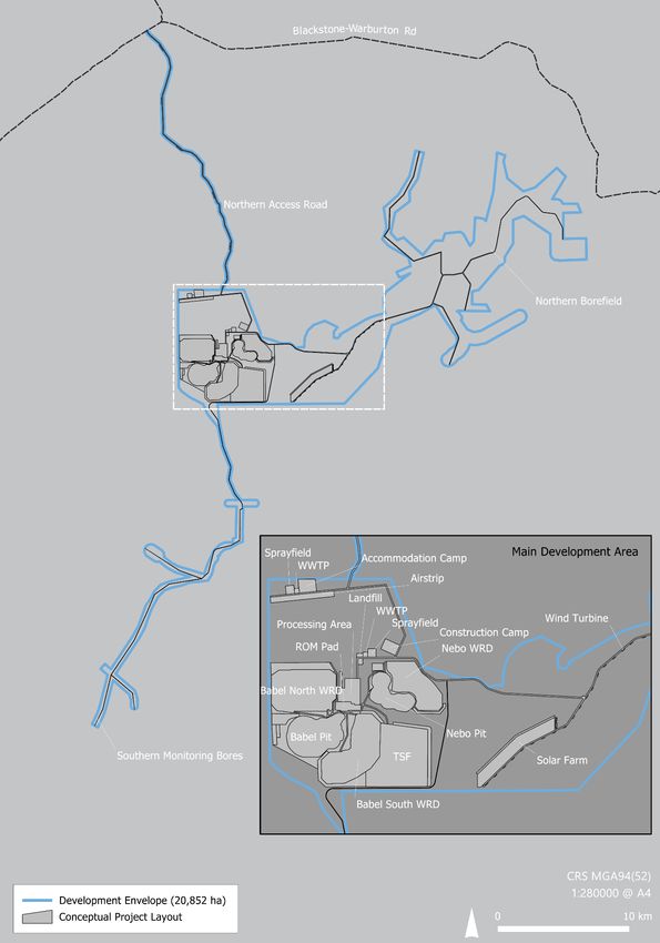
West Musgrave Copper and Nickel Project
                                                                     Groundwater Monitoring and Management Plan

List of Figures
Figure 1: Site Location ........................................................................................................................................................................................... 9
Figure 2: Location of Key Physical and Operational Elements .......................................................................................................... 10
Figure 3: Location of Identified Groundwater Related Environmental Values............................................................................ 12
Figure 4: Kadgo Paleovalley ............................................................................................................................................................................. 15
Figure 5: Estimated Modelled Extent of the 2 m Water Table Drawdown Contour ................................................................. 18
Figure 6: Proposed Groundwater Monitoring Network ....................................................................................................................... 36

List of Tables
Table 1: Summary of Key EMP Information.................................................................................................................................................. 4
Table 2: Key Project Characteristics ................................................................................................................................................................. 8
Table 3: Key Hydrostratigraphy Summary (Youngest to Oldest)...................................................................................................... 14
Table 4: Potential Terrestrial Groundwater Dependent Ecosystems............................................................................................... 20
Table 5: Potential Terrestrial Groundwater Dependent Ecosystems Located Within Those Areas Where More Than
2 m Drawdown is Predicted ............................................................................................................................................................................. 21
Table 6: Key Assumptions and Uncertainties Associated with WMP Groundwater Management .................................... 22
Table 7: Terrestrial Groundwater Dependent Ecosystem Uncertainty Studies ........................................................................... 25
Table 8: Proposed Trigger Criteria and Threshold Criteria for Water Quality............................................................................. 27
Table 9: Nominal Mitigation and Contingency Measures ................................................................................................................... 29
Table 10: Environmental Criteria for Outcome-Based Management ............................................................................................. 31
Table 11: Outcome-based EMP for Groundwater .................................................................................................................................. 33
Table 12: Preliminary Details of Groundwater Monitoring Bores .................................................................................................... 34
Table 13: Summary of Potential Terrestrial Groundwater Dependent Ecosystem Health Monitoring............................. 35

West Musgrave Project                    /   Groundwater Monitoring and Management Plan                                                                                                        Page 6 of 53
West Musgrave Copper and Nickel Project
                                        Groundwater Monitoring and Management Plan

1         CONTEXT, SCOPE AND RATIONALE

This Groundwater Monitoring and Management Plan (GMMP) has been prepared by OZ Minerals to
support the assessment, approval and implementation of the Proposal under Part IV of the
Environmental Protection Act, 1986 (WA) (EP Act). Inland waters are protected under the following State
legislation:
•     Environmental Protection Act, 1986 (WA)
•     Rights in Water and Irrigation Act, 1914 (WA)
•     Country Areas Water Supply Act, 1947 (WA).

In addition to State legislation, the following policy and guidance statements were considered in the
development of this GMMP:
•     EPA Statement of Environmental Principles, Factors and Objectives (EPA, 2020b)
•     EPA Environmental Factor Guideline – Inland Waters (EPA, 2018)
•     Water and Rivers Commission (WRC), Environmental Water Provisions Policy for WA (WRC, 2000).

This GMMP addresses the Notice Requiring Information for Assessment, received from the EPA on
14 April 2021 (the Notice). The Notice requires OZ Minerals to:

      Provide a Groundwater Monitoring and Management Plan which describes how impacts to
      groundwater levels, groundwater quality and health of Groundwater Dependent Ecosystems (GDEs)
      will be managed in accordance with the EPA mitigation hierarchy. The plan should be prepared in
      accordance with the Instructions on how to prepare Environmental Protection Act 1986 Part IV
      Environmental Management Plans (EPA, 2020a). Please provide spatial data defining the 2 metre (m)
      groundwater drawdown contour, the location of the Linton Bore, and the location of the total area of
      GDEs impacted by the
West Musgrave Copper and Nickel Project
Groundwater Monitoring and Management Plan
The project, with a current expected life of approximately 26 years, will consist of:
Mining of copper and nickel ore from two open cut mine pits using conventional blast, load and
haul methods
Placement of mine waste into permanent waste rock dumps (WRDs) and a dedicated tailings storage
facility (TSF) adjacent to mine pit voids
Milling and processing of ore using floatation to produce two separate copper and nickel
concentrates
On-site power supply using a combination of renewable power infrastructure (photovoltaic solar
panels, wind turbines and battery storage) supported by backup thermal power generation
Development of a process/potable water supply borefield that may include a combination of
overland and/or underground pipelines for use during construction and operations
Miscellaneous infrastructure, including stormwater management infrastructure (bunds and drains),
internal roads and service tracks, a dedicated site access road, accommodation village
(approximately 450 beds during operations and 1,200 during construction), airstrip, wastewater
treatment, landfill and other supporting infrastructure including offices, warehouses and workshops
Concentrate transport via existing roads and rail networks.
A summary of the key project characteristics is presented in Table 2.
Table 2: Key Project Characteristics
Elements Location Proposed Extent Authorised
Physical Element
Mine and associated Clearing of up to 3,830 ha of native vegetation within a Development
Figure 2
infrastructure Envelope of 20,852 ha
Operational Element
Below water table mining
Mining voids Figure 2 Nebo pit void to be backfilled above water table post-closure
Babel pit void to be a permanent and episodic pit lake post-closure
Mining waste
Figure 2 Placement of waste rock into permanent WRDs
(waste rock)
Ore processing
Figure 2 Disposal of tailings into a TSF and/or Nebo pit void
waste (tailings)
Up to 60 MW (instantaneous load requirement) of fossil fuel electricity
generation
Power supply Figure 2
Up to 100 MW of photovoltaic solar electricity generation
Up to 100 MW of wind electricity generation
Abstraction of up to 7.5 GL/a of groundwater from the Borefield and
Water supply Figure 2
through mine pit dewatering
West Musgrave Project / Groundwater Monitoring and Management Plan Page 8 of 53West Musgrave Copper and Nickel Project
Groundwater Monitoring and Management Plan
Figure 1: Site Location
West Musgrave Project / Groundwater Monitoring and Management Plan Page 9 of 53West Musgrave Copper and Nickel Project
Groundwater Monitoring and Management Plan
Figure 2: Location of Key Physical and Operational Elements
West Musgrave Project / Groundwater Monitoring and Management Plan Page 10 of 53West Musgrave Copper and Nickel Project
Groundwater Monitoring and Management Plan
1.2 Key Environmental Factor
This GMMP specifically relates to the Water (Inland Waters) factor guidelines. The EPA’s Statement of
Environmental Principles, Factors and Objectives (EPA, 2020b) lists the following as their objective for
Inland Waters (as is relevant to groundwater):
To maintain the hydrological regimes and quality of groundwater…so that environmental values are
protected
1.2.1 Proposal Activities that May Affect the Environmental Objective
This management plan applies to the management of groundwater to the extent that the interaction of
the project may have a negative impact such that the EPA objective may not be achieved. To this end
the following credible events have been identified with the potential to result in negative impacts to
groundwater, specifically:
• Groundwater abstractions from water supply borefield(s) may result in reduced availability and
access to groundwater for beneficial groundwater users, and potential terrestrial groundwater
dependent ecosystems (GDEs)
• Mine dewatering during operations may result in reduced availability and access to groundwater for
beneficial groundwater users, and potential terrestrial GDEs
• Long-term evaporative loss of groundwater from pit voids that remain after closure may result in
reduced availability and access to groundwater for beneficial users, and potential GDEs
• Seepage from waste landforms may impact on groundwater quality to the extent that beneficial uses
are compromised
• Long-term interaction between potentially poor-quality pit void water bodies (that form after
closure) and groundwater may impact groundwater quality to the extent that beneficial uses are
compromised
• Accidental spills of potentially hazardous materials may impact on groundwater quality to the extent
that beneficial uses are compromised.
1.2.2 Site Specific Environmental Values
Two environmental values have been identified in the project area, these are:
• Beneficial use – drinking water supplies (groundwater) provided by Jameson (Mantamaru)
community bores and Linton Bore
• Potential terrestrial GDEs.
The location and spatial distribution of these environmental values are presented in Figure 3. Other
potential environmental values that have been considered but found not to be present in the project
area are described in OZ Minerals (2021).
West Musgrave Project / Groundwater Monitoring and Management Plan Page 11 of 53West Musgrave Copper and Nickel Project
Groundwater Monitoring and Management Plan
Figure 3: Location of Identified Groundwater Related Environmental Values
West Musgrave Project / Groundwater Monitoring and Management Plan Page 12 of 53West Musgrave Copper and Nickel Project
Groundwater Monitoring and Management Plan
1.3 Condition Requirements
A Ministerial Statement and associated conditions are yet to be issued.
1.4 Rationale and Approach
This GMMP outlines how groundwater levels, groundwater quality and the health of potential terrestrial
GDEs will be managed and where relevant monitored, to verify the effectiveness of the management
measures and to ensure potential impacts associated with the proposed construction and operation of
the WMP are minimised. The approach taken includes consideration of:
• Baseline studies relating to hydrogeology, flora and vegetation, terrestrial GDEs and a groundwater
effects assessments (OZ Minerals, 2021; Appendices B1, B2, D2 and D4)
• Hydrogeological numerical modelling (OZ Minerals, 2021; Appendix D3)
• Hydrochemical numerical modelling (OZ Minerals, 2021; Appendix D7 and Appendix D12)
• Relevant assumptions and uncertainties.
1.4.1 Survey and Study Findings
Several studies and surveys have been undertaken to systematically characterise the West Musgrave
hydrogeological regime (including hydrostratigraphy, groundwater quantity and quality, identification
of groundwater-related environmental values, and assessing the effects of mine-related water affecting
activities that have the potential to impact on these environmental values. These studies are summarised
in the following sections and are provided in detail in the EPA Section 38 Referral (OZ Minerals, 2021;
Appendix D).
1.4.1.1 Mine-Related Water Affecting Activities
Mine-related water affecting activities relevant to the project include:
• Mine pit development – interruption of groundwater systems
• Mine dewatering – abstraction of groundwater to provide safe access to the Nebo and Babel
deposits. This water would be used to meet mine and process water demands
• Mine and process water supply – abstraction of groundwater from abstraction bores to supplement
water supply sourced from dewatering
• Materials storages (e.g., TSF, WRDs, topsoil, ore stockpiles) – potential sources of contaminants that
may enter the water table
• Supporting facilities – accommodation, airstrip, renewable energy infrastructure.
West Musgrave Project / Groundwater Monitoring and Management Plan Page 13 of 53West Musgrave Copper and Nickel Project
Groundwater Monitoring and Management Plan
1.4.1.2 Groundwater Conceptualisation
The project is located within the Musgrave Geological Province. The key aquifers of the project area are
associated with the Tertiary sediments of the Kadgo Paleovalley (Table 3). The Kadgo Paleovalley is
represented by a main arterial paleovalley with multiple smaller tributaries along its length (Figure 4)
that are incised into weathered and fractured basement rocks. A detailed hydrogeological baseline
assessment is provided in the EPA Section 38 Referral (OZ Minerals, 2021; Appendix D2).
Table 3: Key Hydrostratigraphy Summary (Youngest to Oldest)
Formation Description
Often occurs above the water table or only partially saturated.
Calcrete
Typically 1 to 15 m thick.
Garford aquifer and Unconfined to semi-confined, interbedded fine sands, silts and clay, thick basal clay
aquitard sequence separating unit from deeper Pidinga aquifer. Up to 90 m thick.
Confined, sands and gravels with interbedded fine sediments, occurs only in deeply
Pidinga aquifer incised sections of Kadgo Paleovalley and is absent in tributary branches.
Typically more than 60 m thick.
Basement aquifer Typically gabbro regolith and fractured rocks, degree of weathering and fracturing
and aquitard reduces with depth. Drains to paleovalley aquifers.
Groundwater flows generally from the north to the south, where it discharges to the Officer Basin
groundwater system approximately 50 km from the Main Development Area. The depth to the water
table typically ranges between four and nine metres, depending on topography, and groundwater
quality is fresh to brackish with salinity (as electrical conductivity) ranging between 950 and 4,500 S/cm.
Nitrate concentrations in groundwater are naturally high compared to other parts of WA, ranging
between 20 and 130 mg/L. Although suitable for livestock (ANZECC, 2000), these concentrations of
nitrate may mean groundwater is unsuitable for human consumption without treatment (NRMMC, 2021).
Groundwater drawn from the Jameson (Mantamaru) bores (Figure 3) has equally high nitrate levels and,
as such, is not suitable for human consumption. A reverse osmosis plant is used to treat water that is
then supplied to the community. Median concentrations of copper, nickel and zinc in groundwater are
below drinking water guideline values (ANZECC, 2000) at 0.002, 0.001 and 0.02 mg/L, respectively.
West Musgrave Project / Groundwater Monitoring and Management Plan Page 14 of 53West Musgrave Copper and Nickel Project
Groundwater Monitoring and Management Plan
Figure 4: Kadgo Paleovalley
West Musgrave Project / Groundwater Monitoring and Management Plan Page 15 of 53West Musgrave Copper and Nickel Project
Groundwater Monitoring and Management Plan
1.4.1.3 Interactions Between the Project and Groundwater
Groundwater Abstractions
The proposed mine water supply borefield (the Northern Borefield) would be located within the Kadgo
Paleovalley. Production bores would be constructed to draw water from the deeper (confined) Pidinga
paleochannel aquifer. Depressurisation of the Pidinga aquifer may induce leakage of some groundwater
from the shallower Garford paleochannel aquifer (predominantly from the basal clay sequence) as well
as from the regolith and fractured bedrock into which the paleovalley is incised, resulting in some
drawdown of the water table around the Northern Borefield. Figure 5 presents the spatial extent of the
predicted 2 m water table drawdown contour around the Northern Borefield during mining. The
maximum predicted water table drawdown within the borefield area is approximately 5 m at the site of
abstraction bores. Groundwater in the borefield has been modelled to return to within 10% of pre-mine
levels within 10 to 20 years following the cessation of borefield abstraction.
The orebodies targeted by mining of the Nebo pit and Babel pit occur below the water table and
therefore require active dewatering to allow safe and efficient access to the ore. The following briefly
describes the dewatering process and provides a description of the effects (see OZ Minerals, 2021;
Section 7.3.3.2):
• The western half of the proposed Nebo pit is located on a minor tributary of the Kadgo Paleovalley
and will intersect up to 90 m of the Garford water table aquifer at this location. The eastern portion
of the pit is located adjacent to this minor tributary and will not intersect paleovalley sediments.
Mining at Nebo pit will require dewatering of the Garford aquifer to allow access to the orebody. As
the Garford aquifer and adjacent / underlying orebody becomes depressurised due to dewatering,
groundwater from the Garford aquifer (upstream and downstream) and basement rocks will move
toward the pit creating a ‘cone’ of water table drawdown around the pit. After mining of Nebo is
completed, the pit will be backfilled to above the pre-mine water table with waste materials, allowing
groundwater to recover to around pre-mine levels and prevent ongoing evaporative losses that
would occur if the pit were to be left open.
• The Babel pit is located entirely outside of the Kadgo Paleovalley within the regolith and fractured
basement rock. This material will also need to be dewatered, also causing a cone of water table
drawdown around the pit, which will combine with the cone of drawdown caused by dewatering of
the Nebo pit. After mining, Babel pit will remain open resulting in ongoing evaporative losses of
groundwater from the basement rocks.
OZ Minerals’ strives to minimise water use and add value when we do, as such OZ Minerals will minimise
the potential for water wastage through utilising dewatered water from two open pits and minimise the
total water abstraction requirements from the Northern Borefield. In particular, the sequencing of
dewatering and mining Nebo pit, which contains most of the mine pit dewatering needs, has been
West Musgrave Project / Groundwater Monitoring and Management Plan Page 16 of 53West Musgrave Copper and Nickel Project
Groundwater Monitoring and Management Plan
purposefully scheduled to coincide with the operation of the processing facility to make best use of
Nebo pit dewatered water.
Figure 5 presents the spatial extent of the predicted long-term (post-mining) 2 m water table drawdown
contour around the former mine pits. Further detail regarding this assessment can be found in
Appendix D3 and Appendix D4 of the EPA Section 38 EP Referral (OZ Minerals, 2021).
Mine Waste Management
Geochemical and physical characterisation of waste rock and tailings has been undertaken to assist in
understanding the water-related risks associated with long-term mine waste management. The studies
show that tailings are unlikely to generate problematic leachate 1 and that waste rock has generally low
levels of potentially acid forming materials. The studies have informed the design of the tailings storage
facility (TSF) and waste rock dumps (WRDs) to ensure mine wastes are appropriately contained to
minimise any environmental impact.
Hydrochemical numerical modelling has also been undertaken (OZ Minerals, 2021; Appendix D7 and
Appendix D12) to assess the fate and transport of any leachate arising from waste storages that may
reach the water table. The modelling adopted a number of very conservative assumptions, and
predictions relating to effects are also considered conservative. The results show the concentrations of
leachate constituents attenuate to guideline levels within short distances of the TSF and WRDs (i.e. within
tens to hundreds of metres).
1
Problematic leachate is defined as leachate with concentrations of Constituents of Concern in excess of adopted
guideline values.
West Musgrave Project / Groundwater Monitoring and Management Plan Page 17 of 53West Musgrave Copper and Nickel Project
Groundwater Monitoring and Management Plan
Figure 5: Estimated Modelled Extent of the 2 m Water Table Drawdown Contour
West Musgrave Project / Groundwater Monitoring and Management Plan Page 18 of 53West Musgrave Copper and Nickel Project
Groundwater Monitoring and Management Plan
1.4.1.4 Interactions Between the Project and Environmental Values
Community Water Supplies
Groundwater is utilised to meet some or all of community water supply requirements in the broader
project area. Community water at the nearest community to the project, Jameson (Mantamaru), is drawn
from the community bores approximately 26 km north of the proposed mine. Prior to reticulation for
community use, the community bore water is treated using reverse osmosis to remove naturally
occurring nitrates. Linton Bore is located approximately 3 km south-west of the most southern
production bore of the Northern Borefield and is used from time to time by the community when visiting
the area for cultural activities. The locations of these community water bores are shown on Figure 3.
Community water supplies are discussed in more detail in the groundwater baseline assessment
undertaken for the EPA Section 38 EP Referral (OZ Minerals, 2021; Appendix D2).
The Jameson (Mantamaru) bores occur approximately 20 km north of the predicted 2 m water table
drawdown contours associated with mine-related activities (Figure 5). Publicly available data indicates
that the Jameson bores are hosted within fractured rock aquifers which represents a different
hydrogeological system to those of the project water supply and dewatering bores. Linton Bore is
located within the life-of-mine 2 m water table drawdown contour that is predicted to develop around
the Northern Borefield (Figure 5). It is likely that Linton Bore intersects paleovalley sediments, similar to
those that will be accessed by the Northern Borefield production bores and the Nebo dewatering bores.
It is assessed that Linton Bore water levels may be drawn down by between 2 m and 3 m as a result of
project water abstraction. For further detailed discussion, refer to the Groundwater Effects Assessment
undertaken for the EPA Section 38 EP Referral (OZ Minerals, 2021; Appendix D4).
Potential Terrestrial GDEs
An assessment of potential terrestrial GDEs in the West Musgrave area has been conducted (OZ Minerals,
2021; Appendix B2). The assessment reviewed the results of a detailed survey of vegetation associations
and mosaics, the physical setting where terrestrial GDEs might exist, including landscape, soils and
available water sources (soil water as well as groundwater), and an extensive literature review (see
OZ Minerals, 2021; Appendix B2). A conceptualisation of groundwater use by potential terrestrial GDEs
provides the context for their level of sensitivity to altered groundwater conditions arising from
groundwater abstraction and dewatering of mine pits. The approach to assessing whether potential
terrestrial GDEs will be adversely affected by mine-related water affecting activities involved the
following assumptions:
• Plants will use soil water, when available, in preference to groundwater
West Musgrave Project / Groundwater Monitoring and Management Plan Page 19 of 53West Musgrave Copper and Nickel Project
Groundwater Monitoring and Management Plan
• There are no impediments (such as hardpans) to depth of rooting (however, the geological database
does indicate calcrete platforms are commonplace throughout the project area which limit tree
rooting depth)
• A typically restricted soil water zone (as evidenced by shallow water tables) combined with an arid
climate suggests some degree of groundwater dependence may occur in larger plant species, at
least during prolonged drought periods
• Larger tree species will likely have larger environmental water requirements than smaller tree and
shrub species, and grasses.
Based on the potential terrestrial GDE assessment (OZ Minerals, 2021; Appendix B2) and the assumptions
outlined above, Table 4 lists vegetation associations and mosaics comprising key vegetation species that
have been identified as potentially reliant to some degree on groundwater. Figure 3 presents the spatial
distribution of these associations/mosaics across the project area. While all potential terrestrial GDE
associations identified in the survey area are considered widespread in the landscape, they do not
include species or communities of conservation significance. A reduction in health and/or death of
vegetation as a result of project-related water-affecting activities, however, may be perceived as an
impact to the cultural landscape from the perspective of Traditional Owners.
Table 4: Potential Terrestrial Groundwater Dependent Ecosystems
Located within 2 m Water
Vegetation Association/Mosaic Abbreviation
Table Drawdown Contour
Acacia kempeana Shrubland and Hard pan Mulga
AkS/HPMW mosaic No
Woodland
Calcrete Corymbia opaca Woodland CCoW Yes
Calcrete Platform Hummock Grassland Hummock
CPHG Ae No
Grassland with Acacia eremophila
Calcrete Platform Hummock Grassland Hummock
CPHG Me No
Grassland with Melaleuca eleuterostachya
Eremophila duttoni Shrubland Eds No
Low Mallee Woodland and Melaleuca glomerata
LMW/MgAkS mosaic No
Acacia kempeana Shrubland
Melaleuca glomerata Acacia kempeana Shrubland
MgAKS/HPMW mosaic No
and Hard pan Mulga Woodland
West Musgrave Project / Groundwater Monitoring and Management Plan Page 20 of 53West Musgrave Copper and Nickel Project
Groundwater Monitoring and Management Plan
Located within 2 m Water
Vegetation Association/Mosaic Abbreviation
Table Drawdown Contour
Sand plains with Wattles other than Mulga over
Spinifex and Calcrete Platform Hummock SAWS/CPHG mosaic Yes
Grassland
The most significant risk posed to terrestrial GDEs (should they be confirmed to be present) in the project
area associated with mine-related water affecting activities is removal of access to groundwater for
meeting environmental water requirements, i.e. water table drawdown arising from groundwater supply
development and mine dewatering. OZ Minerals has relied upon Froend and Loomes (2004) in regard
to adopting a threshold for assessing effects of drawdown magnitude on terrestrial phreatophytic
vegetation. The threshold assumes that a groundwater drawdown of more than 2 m, regardless of the
rate of change, may result in a discernible change to the ecological integrity and biological diversity of
these potential terrestrial GDEs. It is noteworthy however that a highly precautionary approach to
assessing potential impacts to potential terrestrial GDEs in and near-to areas extending into cultural
heritage and natural resource priority areas in the vicinity of Cavanaugh Range/Linton Bore and other
areas as agreed with the Ngaanyatjarra Council. In these areas it is recommended that a more
precautionary approach is taken and consideration should be given that potential terrestrial GDEs may
experience changes in health were the water table is reduced between 2 m and 0.5 m.
Table 4 and Figure 3 present the vegetation associations/mosaics that are likely to have key species that
may have some form of groundwater dependence and are exposed to reduced groundwater access
based on this 2 m drawdown threshold. Table 5 presents details identifying the areas of potential GDEs
(vegetation associations/mosaics) that may be impacted by water table drawdown in excess of 2 m in
the broader project area and within the 2 m drawdown contour (where drawdown of more than 2 m is
predicted).
Table 5: Potential Terrestrial Groundwater Dependent Ecosystems Located Within Those Areas
Where More Than 2 m Drawdown is Predicted
Proportion of Potentially
Vegetation Association/ Total Mapped Area Potentially
Impacted Area to Mapped
Mosaic Area (ha) Impacted (ha)
Area (%)
CCoW 455.3 41.5 11
SAWS/CPHG mosaic 775.9 97 15
West Musgrave Project / Groundwater Monitoring and Management Plan Page 21 of 53West Musgrave Copper and Nickel Project
Groundwater Monitoring and Management Plan
1.4.2 Key Assumptions and Uncertainties
This GMMP has been developed using all relevant and available information at the time of preparation.
The key assumptions and uncertainties associated with this current GMMP are described in Table 6.
Table 6: Key Assumptions and Uncertainties Associated with WMP Groundwater Management
ID Assumption/Uncertainty Description
A1 Groundwater The Development Envelope and surrounds have been the subject of several
conceptualisation groundwater studies and investigations. It is assumed that these
investigations and studies have adequately characterised the hydrogeological
regimes in terms of quantity, quality and potentially dependent
environmental values in the project area; and estimated, through
hydrogeological and hydrochemical numerical modelling, the drawdown
associated with mine pit dewatering and borefield abstractions, and water
quality effects of potential leachate migration away from waste landforms.
The assumption is supported by the hydrogeological numerical model
independent peer-review.
A2 Impact assessment The conceptual groundwater model has adequately assessed the effect of
Northern Borefield groundwater abstractions from the deep Pidinga aquifer
on Garford aquifer water table elevation and drawdown extent, and the
dewatering effects on Garford aquifer and basement water table elevations
and drawdown extent. The assumption is supported by the hydrogeological
numerical model independent peer-review.
A3 Ecosystem health It is assumed that, for the purposes of this GMMP, ecosystem health is
related to access to appropriately defined Environmental Water Provisions
(EWP) (WRC, 2000) represented by water table depth and groundwater
quality.
A4 Terrestrial GDE assessment The terrestrial GDE assessment identified the presence of 376.6 ha of
potential terrestrial GDEs inside the 2m water table drawdown contour that
may be affected by the project water affecting activities.
U1 Location of the 2 m The hydrogeological numerical model has been informed by data collected
drawdown contour from 13 groundwater test bores and geophysical methods. Some uncertainty
remains relating to the homogeneity of the aquifer system between these
test bores, and as such the configuration of the borefield may vary
(i.e. number and exact location of bores). Any material variation to the
configuration of the borefield has the potential to alter the location of the
predicted 2 m water table drawdown contour. This uncertainty will be further
reduced through an additional drilling campaign prior to project operations
and subsequent refinement of the hydrogeological numerical model if
required.
West Musgrave Project / Groundwater Monitoring and Management Plan Page 22 of 53West Musgrave Copper and Nickel Project
Groundwater Monitoring and Management Plan
ID Assumption/Uncertainty Description
U2 Vegetation survey effort While flora and vegetation surveys have been undertaken in much of the area
encompassing the predicted 2 m drawdown contour, large areas remain
unsurveyed due to the significant size of the updated ‘worst case’ 2m
groundwater drawdown contour (Appendix C) and challenges of gaining
cultural heritage access in the project timeframes, particularly in the area near
to the Cavanaugh Range/Linton Bore. As a result, there may be some
additional areas of potential terrestrial GDEs that remain unsurveyed within
the predicted 2 m drawdown contour. Table 7 documents additional work
planned to reduce this uncertainty. Results from this additional work will
inform future updates to this management plan.
U3 Terrestrial GDE assessment The terrestrial GDE assessment has relied on literature, remote-sensing
imagery and professional judgement to identify vegetation associations/
mosaics that may represent terrestrial GDEs that could be impacted by the
project. Field studies (e.g. measurements of leaf water potentials, etc) could
supplement this data to further reduce uncertainty. Table 7 highlights
additional work planned to reduce this uncertainty. Results from this
additional work will inform future updates to this management plan.
U4 Vegetation-specific Further studies, coupled with ongoing monitoring, is required to better
Environmental Water understand the tolerance of terrestrial GDEs to water table drawdown, and
Provisions thereby inform the EWP required to sustain ecosystem function. Table 7
highlights additional work planned to reduce this uncertainty. Results from
this additional work will inform future updates to this management plan.
To provide assurance on our current understanding of potential GDEs, and the approach to further
reduce uncertainties, a review was undertaken by AQ2 (OZ Minerals, 2021; Appendix B2 Addendum 1)
and is also provided here as Appendix A. The review was undertaken to confirm the adequacy of the
approach taken, and to assist with identifying the appropriate next steps to reduce uncertainty
associated with the potential presence of GDEs at WMP.
The review concluded that in a number of regards the existing assessment may have identified larger
areas of GDEs than may be the case. In addition, the review has identified a number of further actions
to reduce uncertainties associated with the existing GDE assessment. These additional actions are
considered in this GMMP. Table 7 identifies a number of studies proposed to reduce the level of
uncertainty relating to the presence of potential terrestrial GDEs, and responses in vegetation to changes
in environmental water availability. These studies have been developed as environmental objectives
(management objectives) and their output would be used to inform ongoing monitoring and
management initiatives and where necessary any updates to trigger criteria and threshold criteria
proposed in this GMMP.
With the exception of the natural resource priority areas in the vicinity of Cavanaugh Range/Linton Bore
and other areas as agreed with the Ngaanyatjarra Council where a precautionary approach will be taken
of assuming potential impacts to potential GDEs of groundwater drawdown of 0.5 m; based on the
West Musgrave Project / Groundwater Monitoring and Management Plan Page 23 of 53West Musgrave Copper and Nickel Project
Groundwater Monitoring and Management Plan
existing and available published science, semiqualitative GDE studies, and peer-review of the existing
GDE work, for all other areas the ‘worst case’ 2 m drawdown contour has been retained as the ‘area of
potential impact to groundwater dependent vegetation’. Notwithstanding, Table 7 has identified
provisions for updating these limits should additional GDE work confirm groundwater dependence, and
where ecohydrology studies indicate that impacts could be realised with drawdown of the water table
by less than 2 m.
West Musgrave Project / Groundwater Monitoring and Management Plan Page 24 of 53West Musgrave Copper and Nickel Project
Groundwater Monitoring and Management Plan
Table 7: Terrestrial Groundwater Dependent Ecosystem Uncertainty Studies
Uncertainties identified in Table 6 EPA Factor: Inland Waters
Objective: To maintain the hydrological regimes and quality of groundwater…so that environmental values are protected
Key Environmental Values: Ecosystem health of potential groundwater dependent terrestrial vegetation and beneficial use of groundwater
Key Impacts and Risks:
• Change to groundwater quality and quantity adversely impacts beneficial use and ecosystem health. The changes may arise due to:
o Groundwater drawdown associated with groundwater supply development and mine dewatering
o Evaporative losses of groundwater from final pit voids, and interaction between pit void(s) and groundwater
Uncertainty Management Actions Monitoring Timing
Uncertainty 2: While flora and vegetation surveys have • Map and report previously unmapped potential terrestrial GDE Vegetation mapping using high-resolution aerial imagery, and Prior to the commencement of mine dewatering and
been undertaken in much of the area encompassing the associations within all of the 2 m water table drawdown contours, the where necessary, and where access allows, ground truthing using borefield abstraction.
predicted 2 m drawdown contour, some areas remain 0.5 m water table drawdown contours in all natural resource priority the establishment of vegetation survey quadrates.
unsurveyed largely due to cultural heritage access areas in the vicinity of Cavanaugh Range/Linton Bore and in any other
restrictions. As a result, there may be some additional priority areas as agreed between the Ngaanyatjarra Council and
areas of potential terrestrial GDEs that remain OZ Minerals, (this may require reliance on the use of high-resolution
unsurveyed within the predicted drawdown contours. imagery).
• The Ngaanyatjarra Ranger Team will be invited to participate in any on
ground flora and vegetation survey activities (subject to fair and
reasonable commercial terms)
Uncertainty 3: The terrestrial GDE assessment has • Undertake field-based terrestrial GDE assessments to identify the Conduct the following analysis on a minimum of 10 potential Prior to the commencement of mine dewatering and
relied on literature, remote-sensing imagery and degree of groundwater dependence (if any) of key plant species within terrestrial GDE trees (or as otherwise agreed with EPA or an borefield abstraction.
professional judgement to identify vegetation vegetation associations and mosaics identified as possible terrestrial appropriately qualified ecohydrology specialist) within each
associations/mosaics that may represent terrestrial GDEs to determine environmental water requirements. identified potential terrestrial GDE (as described in Table 4):
GDEs that could be impacted by the project. Field • Field-based terrestrial GDE assessments of a stand of Desert Oaks
studies (e.g. measurements of leaf water potentials, etc) • Leaf water potential (LWP) measurements
(Allocasuarina decaisneana) known as Exclusion Zone 2, 7.6 km from
could supplement this data to further reduce the main development area (outside all known drawdown contours. • Stand/stem basal area calculation
uncertainty.
• Invite the Ngaanyatjarra Council (and their associated specialists) to be • Measure isotopic composition of groundwater, soil water and
involved in the scoping of terrestrial GDE assessments. plant (xylem) water
The Ngaanyatjarra Ranger Team will be invited to participate in any field-
based terrestrial GDE survey activities (subject to fair and reasonable
commercial terms)
Uncertainty 4: Further studies, coupled with ongoing • Assess environmental water requirements of potential terrestrial GDEs Undertake ongoing seasonal monitoring, for a period adequate to Ongoing seasonal monitoring to be undertaken
monitoring, is required to better understand the and quantify suitable EWPs for all identified terrestrial GDEs identified reduce uncertainty, comprising: quarterly following the commencement of mine
tolerance of terrestrial GDEs to water table drawdown, within the impacted area (i.e. within the 2 m drawdown contour). dewatering and borefield abstraction.
• LWP
and thereby inform the EWP required to sustain • Based on these studies refine water table drawdown and groundwater
• Water table depth (continuous data collection using a transducer
ecosystem function. quality EWP that are considered protective of ecosystem health and
or similar)
update trigger criteria, threshold criteria and management within this
Note: ongoing assessment of EWP would only be
GMMP as required.
required should the baseline assessment (detailed in
Uncertainty 3) confirm that identified potential • The Ngaanyatjarra Ranger Team will be invited to participate in any
field-based terrestrial GDE survey activities (subject to fair and
terrestrial GDE associations, are groundwater
reasonable commercial terms)
dependent.
West Musgrave Project / Groundwater Monitoring and Management Plan Page 25 of 53West Musgrave Copper and Nickel Project
Groundwater Monitoring and Management Plan
1.4.3 Management Approach
The management approaches discussed in this document are based and developed around the
mitigation hierarchy of avoid and minimise to ensure impacts to environmental values have been
avoided or reduced to as low as reasonably practicable. In particular the management approach is based
on the following actions:
• A baseline monitoring and trigger-location bore network
• Establishing appropriate environmental criteria for trigger and threshold levels (provisional triggers
are provided, to be confirmed after further input from the Water Branch of Government of Western
Australia’s Department of Water and Environmental Regulation (DWER))
• Periodic reviews of the hydrogeological numerical modelling and groundwater monitoring based
on operational data
• Ongoing refinement of uncertainty through further information gathering and test-work where
necessary
• Adaptive management of the water abstraction infrastructure (pumping locations and rates) to meet
the trigger and threshold levels
• Delaying or avoiding certain abstraction regions to comply with trigger and threshold levels.
This GMMP uses outcome-based provisions to ensure the EPA’s objectives for Inland Waters is achieved.
1.4.4 Rationale for Choice of Environmental Criteria
Site-specific environmental criteria are based on the following rationale.
Impact of groundwater drawdown on potential terrestrial GDEs: Potential terrestrial GDEs and their
locations in the landscape have been identified from flora and vegetation surveys and a semi-
quantitative review of the vegetation’s potential reliance on groundwater (OZ Minerals, 2021;
Appendix B2). The most significant risk posed to potential terrestrial GDEs in the project area associated
with mine-related water affecting activities is removal of access to the water table (capillary fringe) for
meeting environmental water requirements i.e., water table drawdown arising from groundwater supply
development and mine dewatering. A trigger level of 68% of the predicted drawdown expected to
impact potential terrestrial GDEs is proposed2, whereby trigger-reporting, increased monitoring and
further assessments are activated.
Impact of groundwater drawdown on beneficial groundwater users: Hydrogeological assessments
predict that existing groundwater users accessing Jameson (Mantamaru) community Bore and Linton
Bore will not be impacted by groundwater drawdown (OZ Minerals, 2021; Appendix D). However, a
2
68% represents one standard deviation from the mean of the baseline level
West Musgrave Project / Groundwater Monitoring and Management Plan Page 26 of 53West Musgrave Copper and Nickel Project
Groundwater Monitoring and Management Plan
precautionary approach is adopted whereby triggers are used to validate these assumptions. Proposed
provisional triggers are based on modelled water table drawdown contours.
Validating hydrochemistry numerical modelling outputs: Hydrochemistry assessments indicate that
existing groundwater users will not be impacted by potential groundwater contamination arising from
waste landforms. However, a precautionary approach is adopted whereby triggers are used to validate
model assumptions. A hydrochemical study (OZ Minerals, 2021; Appendix D7 and Appendix D12)
conducted to assess the fate of potential contaminants in groundwater that may arise from waste
landform seepage identified three key constituents of concern (copper, nickel and sulfate) that could
occur at concentrations in seepage waters that exceed adopted guidelines for protection of water quality
(NRMMC, 2021). Proposed provisional triggers are based on the hydrochemistry numerical modelling
and baseline water quality data and include copper, nickel and sulfate as well as salinity (as electrical
conductivity). Table 8 presents the adopted trigger and threshold criteria.
Table 8: Proposed Trigger Criteria and Threshold Criteria for Water Quality
Basement
Garford Aquifer
Parameter Hydrostratigraphic Unit (HSU)
Trigger[1] Threshold[2] Trigger[1] Threshold[2]
Electrical conductivity (S/cm) 2,600 3,000 1,500 1,700
Copper (mg/L) 2 3 0.5 4
Nickel (mg/L) 0.9 3 0.5 4
Sulfate (mg/L) 250 270 120 150
Notes: 1. Based on 80th percentile for reported values for all water samples collected from specific HSU
2. Based on maximum reported value for all water samples collected from specific HSU
1.4.5 Rationale for Choice of Trigger Level Actions and Threshold Contingency Actions
Site specific management targets are based on the following rationale.
Impact of groundwater drawdown on potential terrestrial GDEs: Proposed provisional triggers are
based on the hydrogeological numerical model predictions. A trigger level of 68% of the predicted
drawdown is proposed, whereby trigger-reporting, increased monitoring and further assessments are
activated along with early contingency actions (if deemed necessary). A threshold level equal to the
predicted drawdown is proposed as a provisional level for pre-emptive impact-mitigation measures.
Example mitigation and contingency measures, should these triggers and thresholds be met, are shown
in Table 9.
West Musgrave Project / Groundwater Monitoring and Management Plan Page 27 of 53West Musgrave Copper and Nickel Project
Groundwater Monitoring and Management Plan
Impact of groundwater drawdown on beneficial groundwater users: Proposed provisional triggers
are based on the hydrogeological numerical model predicted water table drawdowns. Triggers are based
on comparison of regional-response data.
Example mitigation and contingency measures should these triggers and thresholds be met are shown
in Table 9. If unexpected drawdown impacts to existing groundwater users accessing Jameson
(Mantamaru) community Bore and Linton Bore are identified, OZ Minerals would provide alternative
water sources.
Validating hydrochemistry numerical modelling outputs: To confirm that hydrochemistry impact
extent is no greater than that predicted by the hydrochemistry numerical model:
• A trigger criteria equal to the 80th percentile reported concentration for each identified analyte (see
Table 8) and evidence of an increasing trend is proposed for groundwater samples collected from
individual monitoring bores at the extent of the hydrochemical numerical model. Reaching this
trigger criteria would activate increased monitoring and further assessments.
• A threshold criteria of 100% of the maximum reported concentration for each identified analyte (see
Table 8) and evidence of an increasing trend is proposed for groundwater samples collected from
individual monitoring bores at the extent of the hydrochemical numerical model. A threshold level
equal to 100% of the maximum concentration is proposed as a provisional level for pre-emptive
impact-mitigation measures.
Example mitigation and contingency measures, should these triggers and thresholds be met, are shown
in Table 9.
West Musgrave Project / Groundwater Monitoring and Management Plan Page 28 of 53You can also read