ŌTAKI TO NORTH OF LEVIN DBC - DRAFT MULTI CRITERIA ANALYSIS REPORT: ASSESSMENT OF NEW HIGHWAY ALIGNMENT, INTERCHANGE AND LOCAL ROAD OPTIONS - NZTA
←
→
Page content transcription
If your browser does not render page correctly, please read the page content below
ŌTAKI TO NORTH OF LEVIN DBC

DRAFT MULTI CRITERIA ANALYSIS REPORT: ASSESSMENT OF
NEW HIGHWAY ALIGNMENT, INTERCHANGE AND LOCAL
ROAD OPTIONS

PREPARED FOR WAKA KOTAHI
JULY 2020
This document has been prepared for the benefit of Waka Kotahi. No liability is accepted by this
company or any employee or sub-consultant of this company with respect to its use by any other person.
This disclaimer shall apply notwithstanding that the report may be made available to other persons for an
application for permission or approval to fulfil a legal requirement.

QUALITY STATEMENT
PROJECT MANAGER                                                                PROJECT TECHNICAL LEAD

 Jon England                                                                   Phil Peet

PREPARED BY

 Selwyn Blackmore

CHECKED BY

 Phil Peet

REVIEWED BY

 Phil Peet

APPROVED FOR ISSUE BY

 Jon England

 WELLINGTON
 Level 13, 80 The Terrace, Wellington 6011
 PO Box 13-052, Armagh, Christchurch 8141
 TEL +64 4 381 6700

REVISION SCHEDULE
                                                                 Signature or Typed Name (documentation on file)
 Rev
              Date      Description
 No.                                                                              Checked          Reviewed          Approved
                                                              Prepared by
                                                                                    by                by                by
 1           24/6/20    Draft for Client                     S Blackmore         P Peet           P Peet           P Peet
 2           11/8/20    Version 2 for Client                 S Blackmore         P Peet           P Peet           P Peet
 3           24/8/20    FINAL DRAFT                          S Blackmore         P Peet           P Peet           P Peet

 August 2020 │ FINAL DRAFT │ Project No.: 310203848 │ Our ref: Ō2NL Assessment of New highway Alignment, Interchange and Local Road
                                                                Options
Ōtaki to North of Levin
 Assessment of New Highway Alignment, Interchange and Local Road Options

CONTENTS
1.          Executive summary ................................................................................................................................... 4
2.          Introduction ............................................................................................................................................... 7
3.          Purpose....................................................................................................................................................... 8
3.1        Iwi engagement ......................................................................................................................................... 8
4.          Indicative business case MCA processes ................................................................................................ 8
5.          MCA developmental stages .................................................................................................................... 8
6.          New Highway alignment MCA ................................................................................................................. 9
6.1        Stage 1 - Long to short listing processes................................................................................................... 9
6.2        Stage 2 - Identifying the emerging preferred alignment options ........................................................ 11
6.3        New Highway alignment MCA weighting options ................................................................................ 33
6.4        Summary of MCA analysis for alignment options .................................................................................. 38
6.5        Summary of the recommended emerging preferred alignments ....................................................... 40
7.          Interchange MCA ................................................................................................................................... 41
7.1        Stage 1 - Long to short listing processes................................................................................................. 41
7.2        Stage 2 - Short list to emerging preferred options ................................................................................. 41
7.3        Interchange MCA weighting options ..................................................................................................... 54
7.4        Summary of MCA analysis for interchange options .............................................................................. 59
7.5        Recommended interchange options .................................................................................................... 60
8.          Local road long list .................................................................................................................................. 61
8.1        Long listing processes .............................................................................................................................. 61
8.2        MCA assessor’s evaluation comments ................................................................................................... 62
9.          Next steps ................................................................................................................................................. 72

LIST OF TABLES
Table 1: Assessment areas and summary descriptions (applying to the alignment and interchange options)
          12
Table 2: 6 point scoring system for the MCA evaluations .................................................................................. 16
Table 3 – MCA assessor unweighted scores for New Highway alignment ....................................................... 18
Table 4 – Summary of MCA assessor unweighted evaluation scores for the emerging preferred alignments
          23
Table 5: Workshop low, medium and high ranking weightings (and corresponding numerical rankings) .... 34
Table 6: RMA Section 6 matters and quadruple bottom line weightings ......................................................... 35
Table 7: Evaluation of the weighted and unweighted rankings ....................................................................... 37
Table 8: Emerging preferred alignments recommended for advancement ................................................... 40
Table 9: South Manakau and Kuku interchange location / form and no connection options ...................... 44
Table 10: Kimberley or Tararua interchange location / form ............................................................................ 45

     July 2020 │ FINAL DRAFT │ Project No.: 310203848 │ Our ref: Ō2NL Assessment of New Highway Alignment, Interchange and Local Road
                                                                    Options
                                                                                 Page 1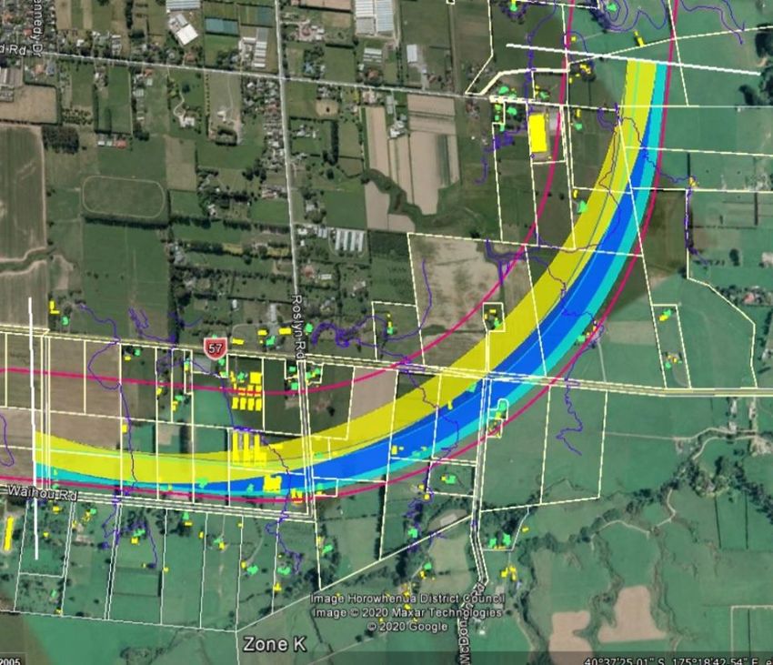
Table 11: “SH1/SH57 Split” interchange form ...................................................................................................... 46
Table 12: North Levin interchange form .............................................................................................................. 46
Table 13: Summary of the MCA evaluation scores for all interchange options ............................................... 47
Table 14: MCA workshop 2 (interchange) weightings ....................................................................................... 55
Table 15: RMA Section 6 matters and quadruple bottom line weightings ....................................................... 56
Table 16: Evaluation of the interchange weighted and unweighted rankings ............................................... 58
Table 17: Interchange location / form options recommended ........................................................................ 60
Table 18: Local Road Zone A red and orange traffic light signals .................................................................... 62
Table 19: Local Road Zone B red and orange traffic light signals ..................................................................... 63
Table 20: Local Road Zone C red and orange traffic light signals .................................................................... 64
Table 21: Local Road Zone D red and orange traffic light signals .................................................................... 65
Table 22: Local Road Zone E red and orange traffic light signals ..................................................................... 65
Table 23: Local Road Zone F red and orange traffic light signals ..................................................................... 66
Table 24: Local Road Zone G red and orange traffic light signals.................................................................... 66
Table 25: Local Road Zone H red and orange traffic light signals .................................................................... 67
Table 26: Local Road Zone I red and orange traffic light signals ..................................................................... 67
Table 27: Local Road (Kimberley Road) Zone J red and orange traffic light signals ...................................... 68
Table 28: Local Road (Liverpool Street) Zone J red and orange traffic light signals ....................................... 69
Table 29: Local Road Zone K red and orange traffic light signals ..................................................................... 69
Table 30: Local Road Zone L red and orange traffic light signals ..................................................................... 70
Table 31: Local Road Zone N red and orange traffic light signals .................................................................... 70
Table 32: Local Road Zone P red and orange traffic light signals ..................................................................... 71
Table 33: Local Road Zone Q red and orange traffic light signals.................................................................... 71

LIST OF FIGURES
Figure 1 – Preferred 300m corridor for the Ōtaki to North Levin New Highway .................................................. 7
Figure 2 – Zone D’s long listed alignment options ............................................................................................... 10

APPENDICES
Appendix A            Ōtaki to North of Levin Detailed Business Case: Initial Alignment Review
Appendix B            MCA Workshops 1 and 2 Attendees
Appendix C            Fit with Project Objectives Report
Appendix D            Landscape and Visual Report
Appendix E            Ecology Report
Appendix F            Heritage Report
Appendix G            Archaeology Report
Appendix H            Noise and Vibration Report
Appendix I            Productive Land Values Report
Appendix J            Social / Community / Recreation Powerpoint

   July 2020 │ FINAL DRAFT │ Project No.: 310203848 │ Our ref: Ō2NL Assessment of New Highway Alignment, Interchange and Local Road
                                                                  Options
                                                                        Page 2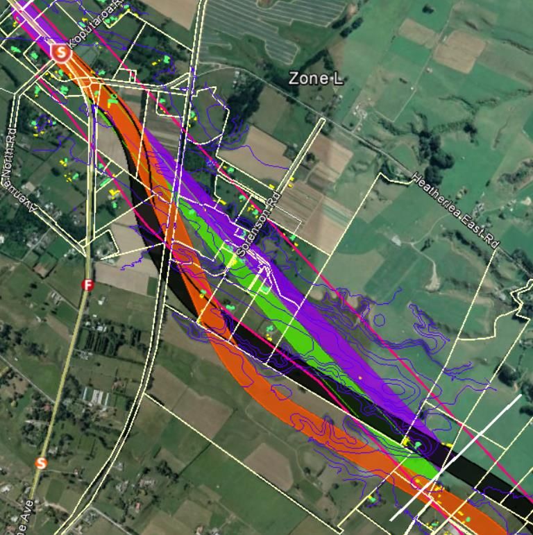
Appendix K       Horowhenua District Development Report (and Fit with Local Road)
Appendix L       Kapiti District Development Memo
Appendix M       Engineering Degree of Difficulty Report
Appendix N       Property Degree of Difficulty Report
Appendix O       Ōtaki to North of Levin Detailed Business Case: Interchange Options Report
Appendix P       Ōtaki to North of Levin Detailed Business Case: Local Roads Access Long List Options Report
Appendix Q       Long list of local road options
Appendix R       Kapiti Coast District Local Road Assessment Memo

 July 2020 │ FINAL DRAFT │ Project No.: 310203848 │ Our ref: Ō2NL Assessment of New Highway Alignment, Interchange and Local Road
                                                                Options
                                                             Page 3
1. Executive summary
This report sets out the outcomes of the initial investigation of the Waka Kotahi NZ
Transport Agency (Waka Kotahi) multi-criteria analysis (MCA) process for the Ōtaki to
North Levin New Highway’s (Ō2NL) detailed business case (DBC). This Project is part of
the NZ Upgrade Programme to “improve safety and access, support economic growth,
provide greater route resilience, and better access to walking and cycling facilities” .
In 2018, Waka Kotahi endorsed an Indicative Business Case, which included endorsement
for a new offline highway and a 300m corridor for further investigation (the preferred
corridor). It is now undertaking a DBC in order to refine the new highway within this 300m
corridor, undertake scheme design and to obtain funding approvals prior to seeking the
required statutory authorisations under the Resource Management Act 1991.
Delivering the MCA process in stages
The Multi Criteria Analysis (MCA) process is being staged as follows:
•   Stage 1 – Long to short list assessment processes in order to identify a short list of
    emerging preferred alignments and interchange locations (and supporting
    interchange form) for detailed MCA evaluation

•   Stage 2 – Short list of emerging preferred alignments and interchange MCAs,
    including MCA Workshops 1 (Alignment) and 2 (Interchanges)

•   Stage 3A – Iwi engagement on emerging preferred alignment and interchange
    options and Iwi MCA scoring (July to September 2020)

•   Stage 3B – Public engagement on draft preferred alignment and interchange
    (August / September 2020)

•   Stage 4 – Preferred alignment and interchange MCA to be held in October 2020
    (with Iwi to be fully involved), and

•   Stage 5 – Recommendation of the preferred alignment and interchange locations
    to Waka Kotahi for final decision-making processes in late 2020.

This report focuses on the outcomes of Stages 1 and 2 – that is, identification of a short list
of emerging preferred alignments and interchange options. A long list of local road
options has also been identified in this report. The identification of these options was
based on the technical assessments undertaken of the emerging preferred alignments
and interchange options. It does not yet take into account scoring from affected Iwi
(although Iwi representatives observed the MCA workshops) and the outcomes of
community engagement.
The MCA process to identify the preferred local road configuration to integrate with the
new highway will be further developed following completion of the August / September
2020 public engagement programme.
Short listed new highway emerging preferred alignments
Following a long to short listing evaluation process, and a comprehensive MCA
evaluation of the short listed options (acknowledging that Iwi scoring is expected at the
end of Stage 3A), the following emerging preferred alignment options were identified:

July 2020 │ FINAL DRAFT │ Project No.: 310203848 │ Our ref: Ō2NL Assessment of New Highway Alignment, Interchange and Local
                                                         Road Options
                                                          Page 4
Zone                       Draft preferred alignment in each New Highway zone

                  A                     Green Alignment (only)

                  B                     White Alignment (only)

                  C                     White Alignment (only)

                  D                     Dark Blue Alignment (only)

                   E                    Green Alignment (only)

                   F                    Both Orange and White Alignments

                  G                     Purple Alignment (only)

                  H                     Cyan Alignment (only)

                  K                     Both Yellow and Dark Blue Alignments

                   L                    Both Orange and Black Alignments

Short listed interchange location / form options
Following a long to short listing technical and MCA evaluation process, the following
interchange location / form options were identified as being technically preferred
(noting that scoring from affected Iwi and the outcomes of community feedback is yet
to be taken into account):

          Location                                  Draft preferred interchange options

                                  No connection, but future proofing for an interchange at
  Manakau / Kuku
                                  South Kuku (form undecided)

  Kimberley or Tararua            Tararua only, noting a preference for grade separation

  “SH1 / SH57 Split”              All interchange options

  North Levin                     Roundabout (only)

Long list of local road options
Using a simplified process, the Project Team identified a long list of local road options
that would ensure local connectivity was retained throughout the corridor. This process
involved producing schematic plans for each option at each relevant location, which
was then assessed through a “traffic signal” evaluation process by the MCA assessors.
These high level assessments will be reviewed during Stage 4.
Ongoing Iwi engagement
The detailed MCA processes to identify the above alignment, interchange and local
road options has been undertaken alongside ongoing discussions with representatives
from Muaūpoko and Raukawa regarding these options. However, as explained above
neither Iwi have yet evaluated or scored any of the options (although both Iwi did
participate in the weightings discussions at each MCA workshop). Waka Kotahi will
continue to engage with both Iwi during Stage 3A, and Iwi will be fully involved during
the Stage 4 process outlined above.

July 2020 │ FINAL DRAFT │ Project No.: 310203848 │ Our ref: Ō2NL Assessment of New Highway Alignment, Interchange and Local
                                                         Road Options
                                                          Page 5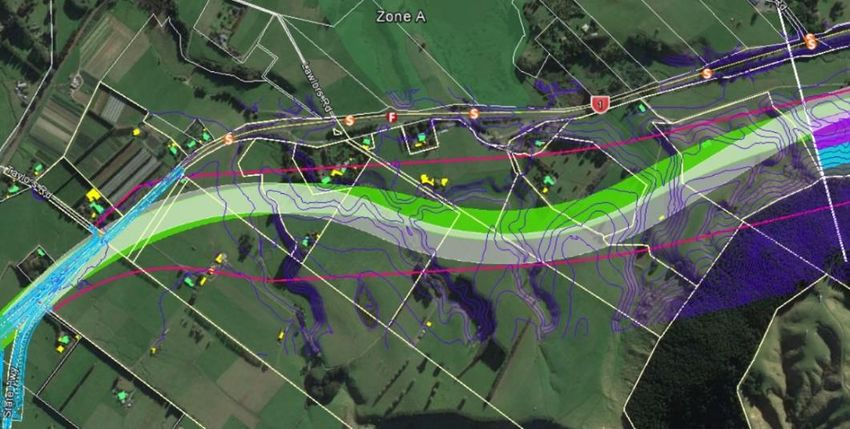
Post new highway MCA
Following completion of the MCA and based on the detailed feedback from the MCA
assessors, the Project Team has undertaken further design refinements for some of the
emerging preferred alignments, interchange location / form options and local road
options. This work principally involved:
•   Design refinements to the emerging preferred alignments in each zone to ensure
    they connected efficiently to the alignments in the adjacent zones and to the
    emerging preferred interchange options

•   Design refinements to the emerging preferred interchange and local road options,
    and

•   Minor design updates to the emerging preferred options in order to respond to the
    recommendations made by the MCA assessors at the MCA Workshops.

The design refinement changes are documented in the Post MCA Update Report
(August 2020).
Next Steps
The next key step is for Waka Kotahi to undertake public engagement on the emerging
preferred options for the highway alignment, interchanges, and local roads. Following
public engagement, a final MCA process will be undertaken in October / November
2020. Following completion of the MCA, the preferred options will be recommended
and presented to Waka Kotahi for final decision-making processes, which is expected
to occur in late 2020.

Waka Kotahi has commenced engagement with Iwi on the emerging preferred options
and will obtain Iwi scoring by the end of Stage 3A. This will feed into Stage 4, during
which Iwi will be fully involved in the MCA process.

It is important to note that the MCA outcomes of Stages 1 to 5 (as set out above) are
not the only factor that will be used in determining the options for consultation and the
preferred alignment, interchange and local road options. These decisions will be made
by Waka Kotahi who must also take into account cost and funding availability, risk and
opportunities, and the desired outcomes of Iwi, the community and key stakeholders.

July 2020 │ FINAL DRAFT │ Project No.: 310203848 │ Our ref: Ō2NL Assessment of New Highway Alignment, Interchange and Local
                                                         Road Options
                                                          Page 6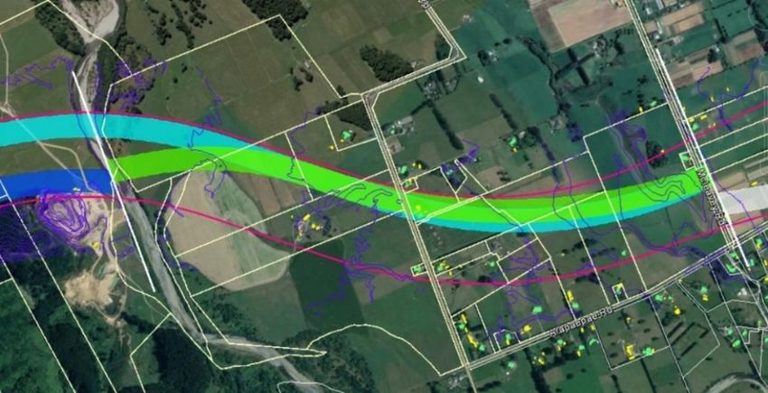
2. Introduction
State Highway 1 (SH1) is New Zealand’s premier highway, but the section between Ōtaki
and Levin is afflicted by a number of serious safety, efficiency and resilience problems.
The importance of this section of SH1 is characterised by its function in connecting
Wellington to the upper North Island, where no other resilient route exists. It also provides
an essential economic connection to Palmerston North, the largest freight node in central
New Zealand.
Therefore, Waka Kotahi NZ Transport Agency (Waka Kotahi) has been investigating
potential upgrades and new alignment options to address the issues with the existing SH1
route. In 2018, an Indicative Business Case (IBC) was endorsed, which included
endorsement for an offline highway from Taylors Road in the south to north of Levin (the
Project or Ō2NL Highway), and a 300m corridor (the preferred corridor) for further
investigation. This Project was subsequently included in the NZ Upgrade Programme to
“improve safety and access, support economic growth, provide greater route resilience,
and better access to walking and cycling facilities”.
Waka Kotahi is now undertaking a Detailed Business Case (DBC) to refine the new
highway alignment, interchange locations / options, and local road connections for the
preferred corridor plus undertake scheme design and obtain funding approvals.
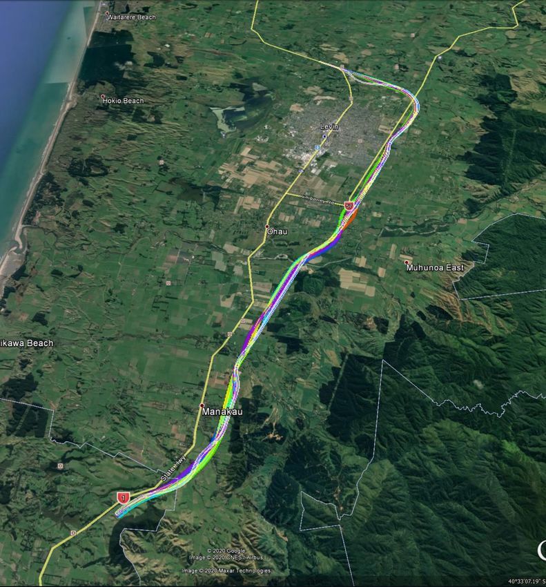
As set out in Figure 1 below, the preferred corridor is located to the east of State Highway
1 (SH1) and State Highway 57 (SH57). In summary, heading north, the proposed new
highway will extend from the northern end of the Peka Peka to Ōtaki Expressway (which
is located approximately 2km north of the Ōtaki township) and will re-connect into SH1
and SH57 to the north of Levin (the New Highway).
Figure 1 – Preferred 300m corridor for the Ōtaki to North Levin New Highway
At the completion of the IBC it was identified that one of the first key activities to be
undertaken to inform the DBC was to undertake multi criteria analysis (MCA) processes
to help identify a preferred alignment within the 300m corridor, the preferred location
for the New Highway’s interchanges and to identify the local road re-configuration and
connections.
July 2020 │ FINAL DRAFT │ Project No.: 310203848 │ Our ref: Ō2NL Assessment of New Highway Alignment, Interchange and Local
Road Options
Page 7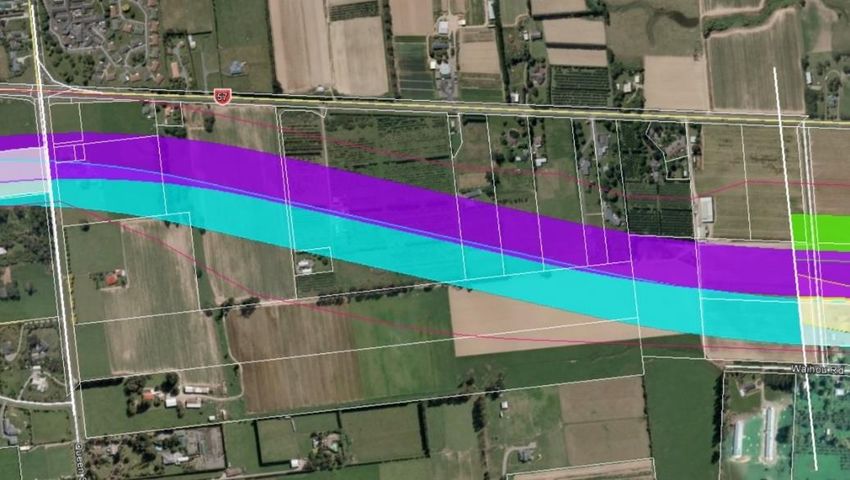
3.         Purpose
The purpose of this report is to set out the MCA processes undertaken to date by the
Ō2NL New Highway’s Project Team, its partners and technical specialists in order to
identify the emerging preferred alignments and interchange locations (and forms) for
further consideration and public consultation.
It is noted that an investigation into local road reconfiguration options to
accommodate the New Highway has also been undertaken. This report documents the
long listing processes, including the Project Team’s initial assessments of the local road
options.

3.1        Iwi engagement
Both Muaūpoko and Raukawa have been observers of the MCA processes undertaken
to date, however formal evaluations or scoring of the emerging preferred alignments,
interchange, and local road options by these affected Iwi is yet to come (although Iwi
did participate in the discussions at each MCA workshop). Rather, both will complete
the Stage 3A process and be fully involved in the Stage 4 of the MCA process (see
below).

4.         Indicative business case MCA processes
In summary, the MCA undertaken to inform the IBC comprised the following:
•    A long list corridor MCA process undertaken in 2017 (which is documented in
     “Identification and assessment of possible route options – multi criteria analysis with
     community involvement”),1 and

•    A long to short list corridor process undertaken in 2018 to identify a preferred corridor
     option (as documented in the IBC itself).

Ultimately, the MCA processes undertaken for the IBC identified the preferred corridor,
being a 300m corridor consisting of Waka Kotahi’s preferred S6 (for the southern section)
and N4 (for the northern section) corridor alignments. The preferred corridor is set out in
Figure 1 above.
Following completion of the IBC, and after considering its recommendations, the Waka
Kotahi Board formally endorsed the preferred corridor at its Board meeting in December
2018.2

5.         MCA developmental stages
The MCA processes to identify emerging preferred alignments and interchange
locations (and supporting forms) are being undertaken in accordance with the
following stages:
•    Stage 1 – Long to short list assessment processes in order to identify a short list of
     emerging preferred alignments and interchange locations (and supporting form) for
     detailed MCA evaluation

•    Stage 2 – Short list of emerging preferred alignments and interchange MCAs,
     including MCA Workshops 1 (Alignment) and 2 (Interchanges)

1 See - https://www.nzta.govt.nz/assets/projects/otaki-to-north-of-levin/docs/technical-reports/mca-
reports/O2NL-Community-MCA-Report-September-2017-Front-only.pdf. It is noted that this report was peer
reviewed by Mitchell Daysh (see - See - https://www.nzta.govt.nz/assets/projects/otaki-to-north-of-
levin/docs/technical-reports/ibc/Otaki-to-North-of-Levin-IBC-20181128.pdf)
2 See Board Meeting minutes from Friday 14 December 2018 (i.e. Resolution 2):

https://www.nzta.govt.nz/assets/About-us-2/docs/board-meeting-minutes-2017/minutes-20181214.pdf
July 2020 │ FINAL DRAFT │ Project No.: 310203848 │ Our ref: Ō2NL Assessment of New Highway Alignment, Interchange and Local
                                                         Road Options
                                                          Page 8
• Stage 3A – Iwi engagement on emerging preferred alignment and interchange
options and Iwi MCA scoring (July to September 2020)
• Stage 3B – Public engagement on draft preferred alignment and interchange
(August / September 2020)
• Stage 4 – Preferred alignment and interchange MCA to be held in October 2020
(with Iwi to be fully involved), and
• Stage 5 – Recommendation of the preferred alignment and interchange locations
to Waka Kotahi for final decision-making processes in late 2020.
Section 6 of this report describes the MCA methodology and evaluation results that
have led to the identification of the emerging preferred alignments.
Section 7 of this report details the MCA methodology and evaluation results that have
led to the identification of recommended interchange location and form options.
As noted above, the Project Team has undertaken a local road long listing process.
Section 8 of this report documents the long listing processes, including the Project
Team’s initial assessments of each long listed option.
6. New Highway alignment MCA
6.1 Stage 1 - Long to short listing processes
In order to identify a short list of emerging preferred alignment options for detailed MCA
evaluation the following steps were undertaken.
6.1.1 Step 1: Identification of fixed points
The Project Team firstly identified / mapped key fixed points along the preferred
corridor. Such points included the preferred corridor’s start and finish points, the
location of known Resource Management Act 1991 (RMA) Section 6 “factors” (e.g.
significant ecological or heritage areas), areas with significant property (e.g. Maori
land) as well as key engineering constraints (e.g. topography). These locations were
identified primarily from the IBC’s constraints and opportunities maps and
topographical data collected by the Project Team.
6.1.2 Step 2: Identification of New Highway alignment zones
Following identification of the fixed points, the Project Team divided the preferred
corridor into zones (ranging from ~1.5km to ~4.5km in length) in order to identify a long
list of emerging preferred alignment options for each zone.
The identification of each zone’s location was based on engineering / environmental
considerations (e.g. topography, preliminary interchange location and waterway
locations).
From this process a total of 10 alignment zones were identified and assigned a letter
(e.g. A, B, C). Some modification to these zones occurred, but it is noted that the
original zone letters were retained (hence some zone lettering not been in alphabetical
order).
6.1.3 Step 3: Generating New Highway alignment options
Next, up to six 80m wide alignments were identified for each zone. Each 80m alignment
option was predicated on horizontal geometry standards, property information and
topographical information plus a review of the IBC constraints and opportunities map s.
Each alignment route mapped was two dimensional (i.e. no vertical alignment aspects
were considered at this point).
July 2020 │ FINAL DRAFT │ Project No.: 310203848 │ Our ref: Ō2NL Assessment of New Highway Alignment, Interchange and Local
Road Options
Page 9It is noted that the Project Team identified that an 80m width for a New Highway
alignment was enough to contain the road carriageway (e.g. four lanes and road
shoulders), a shared path, landscaping, drainage and earthworks in most places.3
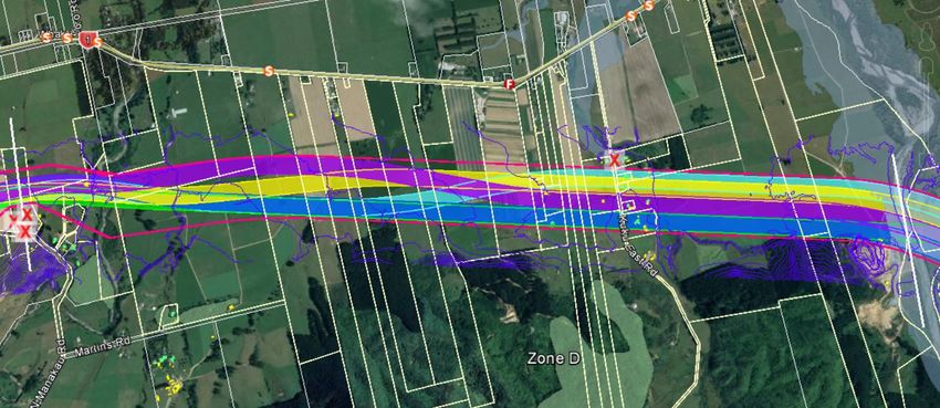
An example of a long list of emerging preferred alignment options for Zone D is set out
in Figure 2 below.
Alignments were identified outside the preferred corridor in two locations:
• Zone F, where there was an identified opportunity to miss the Kimberley /
Arapaepae Road intersection and a cluster of dwellings by having the alignment
further to the east of the preferred corridor, and
• Zone L, where landowner feedback had identified an option of running further south
of the current alignment to keep Sorensons Road intact.
These options were added to the long list and evaluated through the process, noting
that they may have additional adverse landowner impacts that would need to be very
carefully considered before proceeding.
Figure 2 – Zone D’s long listed alignment options
6.1.4 Step 4: Screening the long list of alignment options
The Project Team 4 met in mid-March to determine whether any of the long listed 80m
alignment options could be removed or could be adapted to a more optimal
alignment. This “screening process” was undertaken at a Project Team workshop (held
in mid-March) in two parts as follows:
• Part 1 – comprised reviewing the IBC’s constraints and opportunities maps for the
preferred corridor in order to identify any alignment options that were obviously
fatally flawed (ultimately no alignment options were removed as a consequence of
this review), and
• Part 2 – comprised the Project Team considering the 80m alignments for each zone
and asking itself the following questions:
o Does any alignment impact on a residential dwelling(s)?
o Does any alignment impact on any known community/Iwi assets (including
future Horowhenua District Council (HDC) growth areas)?
3 It is noted that future design stages and designation processes will result in the 80m width being narrowed in
the most part. However, in some areas, the 80m width may increase around interchanges, areas of cut/fill,
drainage and stormwater treatment, parallel service roads and mitigation such as bunding and planting
4 The attendees at the Design Team workshop were: Selwyn Blackmore (Transport Planning Lead), Jamie
Povall (Design Manager), Phil Peet (Team Leader), Keith Weale (Geometrics Lead), April Peckham (Resource
Planner), and Chris Hansen (Lead Resource Planner)
July 2020 │ FINAL DRAFT │ Project No.: 310203848 │ Our ref: Ō2NL Assessment of New Highway Alignment, Interchange and Local
Road Options
Page 10o Does an alignment make reconnecting the local road network more complex?
o Is an alignment located within a flood zone, if so, will it make it more complex to
construct?
o Does the alignment impact on a known/significant ecological area?
o Does the alignment impact on high quality productive land?
o Does an alignment optimise (or compromise) preferred bridge crossing
locations?
o Does the alignment make connecting the alignment in the zones to the south
and/or north more complex to implement?
o Will the local topography for the alignment make constructability more
complex?
o Will the alignment result in sub-optimal property parcel outcomes?
o Will the alignment impact on a special amenity area [as defined by the Kāpiti
Coast District Council’s (KCDC) District Plan]?
If the Project Team’s collective answer was “yes” to any of the above questions, it then
used its professional technical expertise to identify whether alignment option(s) should
be removed from further consideration or adapted to a more optimal alignment.
It is noted that the Project Team acknowledged at the start of the workshop that its long
to short listing recommendations may need to be revisited following completion of
Stages 1 and 2.
6.1.5 Step 5: Documenting the long to short list alignment process
Following completion of the Project Team workshop, a short list of emerging preferred
alignments for each zone were identified for further assessment in the MCA process.
Further information on the long to short list process can be found in the Ōtaki to North of
Levin Detailed Business Case: Initial Alignment Review (12 May 2018) attached as
Appendix A.
6.2 Stage 2 - Identifying the emerging preferred alignment
options
The first step in the short listing of the emerging preferred alignments process was to
identify the relevant MCA assessment criteria for the New Highway alignment (which will
also be used for the interchange location and supporting form), and then to select the
MCA assessors to undertake each assessment.
6.2.1 MCA assessment areas
In conjunction with Waka Kotahi, the Project Team selected the assessment areas as set
out in Table 1 below.
July 2020 │ FINAL DRAFT │ Project No.: 310203848 │ Our ref: Ō2NL Assessment of New Highway Alignment, Interchange and Local
Road Options
Page 11Table 1: Assessment areas and summary descriptions (applying to the alignment and interchange options)
Assessment Criteria Summary of assessment criteria
This assessment criterion involves a high-level assessment of the overall contribution each
alignment and interchange option will make to the following project / RMA objectives:
• Enhance the safety of the State highway network by delivering a four lane State highway
between Ōtaki and North of Levin
• Improve the resilience of the State highway network
Fit with Project Objectives
• Support intra and inter-regional economic growth and productivity through improved
movement of people and freight
• Provide integration between the State highway network and the local road network
including supporting access to multi-modal connections and Levin, and
• Enhance efficiency and journey time reliability along the State highway network.
Environmental / social impacts
This assessment criterion considers the impacts on the Tangata Whenua values associated with
the alignment, interchange and local road options, including past and present associations,
Iwi Cultural Values (Raukawa) key areas of settlement (marae and papakianga), waahi tapu (if known) and other cultural
values, areas of use (e.g. food gathering), current ownership, and important elements of the
natural environment such as waterways and wetlands.5
This assessment criterion considers the impacts on the Tangata Whenua values associated with
the alignment, interchange and local road options, including past and present associations,
Iwi Cultural Values (Muaūpoko) key areas of settlement (marae and papakianga), waahi tapu (if known) and other cultural
values, areas of use (e.g. food gathering), current ownership, and important elements of the
natural environment such as waterways and wetlands. 6
5 This criterion has not yet been scored and therefore this summary may change
6 This criterion has not yet been scored and therefore this summary may change
July 2020 │ FINAL DRAFT │ Project No.: 310203848 │ Our ref: Ō2NL Assessment of New Highway Alignment, Interchange and Local Road Options
Page 12This assessment criterion considers natural and landscape character impacts (including
degree of modification and presence of structures) of the alignment, interchange and local
Landscape/Visual road options. It includes considering potential landscape and urban design impacts of the
alignment on nearby townships or notable lifestyle areas.
This assessment criterion considers the terrestrial and freshwater / wetland impacts. For terrestrial
impacts, the criterion considers terrestrial ecological values such as indigenous vegetation
Ecology (both terrestrial and freshwater / areas that are nationally, regionally or locally significant in terms of habitat values and the
wetland) presence of species. For freshwater / wetland impacts, the criterion considers the potential
effects on waterways (e.g. lakes, rivers and streams) and wetlands.
Heritage This assessment criterion considers the impacts on known heritage buildings.
This assessment criterion considers the impacts on known archaeological sites and features, and
Archaeology the risks of encountering archaeological features, or new areas of significance.
This assessment criterion considers the noise and vibration impacts on dwellings and other
Noise and vibration community buildings (sensitive receptors) located within 300m of the alignment, interchange
and local road options (which don’t require removal).
Productive Land Values This assessment criterion considers the impacts on productive values of Classes I to III soils.
This assessment criterion considers the social / community and recreational impacts on local
Social / community / recreation7 communities, including community severance / opportunities, and construction phase impacts.
Horowhenua District Development (applying This assessment criterion considers the impacts on the approved Horowhenua District Plan’s
to Horowhenua Only) provisions and the confirmed future growth plans for the Horowhenua District.
7 At the time of writing the draft report, engagement work with the affected communities was still being conducted, resulting in these scores remaining ‘provisional’
July 2020 │ FINAL DRAFT │ Project No.: 310203848 │ Our ref: Ō2NL Assessment of New Highway Alignment, Interchange and Local Road Options
Page 13Kāpiti Coast District Development (applying This assessment criterion considers the impacts on the provisions of the approved KCDC District
to the Kāpiti District Only, and alignment Plan and the confirmed future growth plans for the Kāpiti Coast District.
only)
Implementability impacts
This assessment criterion considers the contribution of the alignment and interchange options
to the management of the local road network, including the opportunities to update or
Fit with local road system integrate effectively with the existing roading hierarchy in the Horowhenua district. This
criterion differs from the transport benefits criteria, as it focuses on the local network as a
system in its own right (i.e. receiving and dispatching traffic in the Horowhenua district).
This assessment criterion considers the physical components of the alignment, interchange
and local road options, including: volume and balance of earthworks, structures, complexity
Engineering degree of difficulty of programming and temporary works, traffic and access management during construction,
risks around “unknowns”, any necessary additional provisions to address natural hazards, and
general degree of difficulty in construction.
This assessment criterion considers the number of properties, extent of severance of existing
properties, the general ability to align an option with property boundaries, potential for
Property degree of difficulty effects on farming/business operations, Maori land, and any known land tenure issues that
may create difficulties.
July 2020 │ FINAL DRAFT │ Project No.: 310203848 │ Our ref: Ō2NL Assessment of New Highway Alignment, Interchange and Local Road Options
Page 146.2.2 MCA assessors
In order to ensure consistency of this MCA process with the MCA assessments
undertaken for the IBC in 2017 and 2018, the Project Team selected the same MCA
assessors where it was possible to secure their services.
The MCA assessors selected to undertake the assessments set out in Table 1 above are
as follows:
• Stantec - Fit with Project Objectives
• Raukawa - Iwi Cultural Values (Raukawa)
• Muaūpoko - Iwi Cultural Values (Muaūpoko)
• Isthmus - Landscape / Visual
• Forbes Ecology Limited - Ecology
• Ian Bowman, architect and conservator - Heritage (Built)
• Daniel Parker, Insite Archaeology - Archaeology
• Chiles Ltd - Noise / Vibration
• Land Vision - Productive Land Values
• BECA - Social / Community / Recreation
• Horowhenua District Council - Horowhenua District Development
• Kāpiti Coast District Council - Kāpiti Coast District Development
• Horowhenua District Council - Fit with Local Road System
• Stantec - Engineering Degree of Difficulty
• The Property Group - Property Degree of Difficulty
6.2.3 MCA assessment instructions
Various briefings for the MCA assessors for the New Highway alignment and interchange
options were undertaken between 9 April and 25 May 2020.
The first technical briefing (#1), which was held on 9 April 2020, provided the MCA
assessors with an update on the Project, and an opportunity for them to identify what
additional information they would need to undertake their evaluations.
In early May, the MCA assessors were then issued with further instructions on the MCA
process. These instructions outlined the following:
• There would be two MCA workshops. MCA Workshop 1 would consider the
emerging preferred alignment options, and MCA Workshop 2 would consider the
interchange options (and long list of local roads)
• The key requirements that needed to be delivered by each MCA Assessor for Stage
2 of the MCA process (e.g. participation and presentations in the MCA workshops,
and production of detailed MCA reports)
• The essential information that would need to be identified in the detailed MCA
reports to be delivered for Stage 2, including key background / baseline
information, key assumptions applied 8 to the MCA assessors scoring as well as
8It was noted in the instructions that each MCA assessor was to base their assessments on an assumption of
reasonable mitigation measures being applied to the effects
July 2020 │ FINAL DRAFT │ Project No.: 310203848 │ Our ref: Ō2NL Assessment of New Highway Alignment, Interchange and Local
Road Options
Page 15identifying what additional information might be needed to complete scoring for
the final MCA to be held in Stage 4, and
• The location of the Project sharepoint for sharing and storing MCA evaluation
information.
The second technical briefing (#2) was held on 12 May, at this briefing it was confirmed:
• that the MCA would be undertaken to inform both the DBC and subsequent RMA
processes
• that the following project / RMA objectives would be evaluated:
o Enhance the safety of the State highway network by delivering a four lane
State highway between Ōtaki and North of Levin
o Improve the resilience of the State highway network
o Support intra and inter-regional economic growth and productivity through
improved movement of people and freight
o Provide integration between the State highway network and the local road
network including supporting access to multi-modal connections and Levin,
and
o Enhance efficiency and journey time reliability along the State highway
network.
• the approach for the MCA workshop would be predicated on the Decision
Conferencing approach (i.e. where scoring and weightings are identified through
discussion and consensus, but informed by expert views)
• a 6 point scoring system was to be used for the MCA evaluation as set out in Table 2
below:
Table 2: 6 point scoring system for the MCA evaluations
Score Description
The option presents few difficulties on the basis of the criterion being
1 evaluated and may provide significant benefits in terms of the
attribute
The option presents only minor aspects of difficulty on the basis of the
2 criterion being evaluated, and may provide some benefits in terms of
the criterion
The option presents some aspects of reasonable difficulty in terms of
3 the criterion being evaluated and problems cannot be completely
avoided. There are few apparent benefits in terms of the criterion
The option includes clear aspects of difficulty in terms of the criterion
4
being evaluated, and very limited perceived benefits
The option includes significant difficulties or problems in terms of the
5
criterion being evaluated and no apparent benefits
The option will result in completely unacceptable adverse effects that
F cannot be appropriately avoided, remedied or mitigated (including
offsetting)
• that all scoring should be absolute (that is, no artificial distinctions should be made
between the options)
July 2020 │ FINAL DRAFT │ Project No.: 310203848 │ Our ref: Ō2NL Assessment of New Highway Alignment, Interchange and Local
Road Options
Page 16• that all MCA assessors were to base their evaluations on existing information and to
use their professional expert judgment (but to advise if additional information would
be needed to complete their final MCA evaluations in Stage 4)
• that a workshop weighting would be agreed for the emerging preferred alignments
and interchange options at MCA Workshops 1 and 2 respectively. Other weightings
for RMA Section 6 matters and the quadruple bottom line (i.e. social, environmental,
cultural and economic) would be developed for sensitivity testing purposes, and
• that 3D google earth design files would be provided to provide detail information on
the New Highway alignments (and interchange locations / forms).
6.2.4 Evaluating the New Highway alignments
MCA Workshop 1 for the New Highway alignment was held on 25 May 2020. The
workshop was attended by the MCA assessors, key members of the Project Team,
observers from Waka Kotahi as well as representatives from Raukawa and Muaūpoko.
The names of those who took part in MCA Workshop 1 are provided in Appendix B
(which also includes a list of the attendees that participated in MCA Workshop 2).
The outcomes of the MCA assessors unweighted (i.e. raw) scores for each New Highway
alignment are set out in Table 3 below. Each MCA assessor’s individual unweighted
scores are discussed in the commentary that follows these tables.
As noted above, Iwi did not record scores for the emerging preferred alignment options
(and interchange options). As such no scores were recorded for the Iwi Cultural Values
(Raukawa) and Iwi Cultural Values (Muaūpoko) assessment criterions. No scores have
been recorded in the tables below (as highlighted in yellow).
It is also noted that the MCA assessor for the Kāpiti Coast District Development
assessment criterion only evaluated the emerging preferred alignment options in Zones
A and B. Similarly, the MCA assessor for the Horowhenua District Development
assessment criterion evaluated all New Highway alignment options, except for Zone A.
Accordingly, no scores were recorded in the tables below for the respective columns.
July 2020 │ FINAL DRAFT │ Project No.: 310203848 │ Our ref: Ō2NL Assessment of New Highway Alignment, Interchange and Local
Road Options
Page 17B
A
Zone
options
B -Cyan
B - White
B - White
A -Green
B - Green
Short listed
Table 3 – MCA assessor unweighted scores for New Highway alignment
Short listed option locations
Page 18
Zone
Zone
B - Cyan
B - White
A - White
B - Green
A - Green
1
1
1
1
1
01 - PO - Enhanced movement 01 - PO - Enhanced movement
1
1
1
1
1
01 - PO - Safety 01 - PO - Safety
2
1
1
2
2
01 - PO - Resilience 01 - PO - Resilience
1
1
1
1
1
01 - PO - Connections 01 - PO - Connections
02 - Iwi (Raukawa) 02 - Iwi Raukawa
03 - Iwi Muaupoko 03 - Iwi Muaupoko
2
3
2
5
3
04 - Landscape/visual 04 - Landscape/visual
1
1
4
2
4
05a - Ecology Terrestrial 05a - Ecology Terrestrial
3
3
2
2
2
05b - Ecology freshwater and wetlands 05b - Ecology freshwater and wetlands
1
1
1
1
1
06 - Heritage 06 - Heritage
July 2020 │ FINAL DRAFT │ Project No.: 310203848 │ Our ref: Ō2NL Assessment of New Highway Alignment, Interchange and Local Road Options
3
3
2
2
2
07 - Archaeology 07 - Archaeology
3
3
4
4
4
08 - Noise and vibration 08 - Noise and vibration
3
3
3
3
3
09 - Productive land values 09 - Productive land values
2
2
2
4
3
10 - Social/community/recreation 10 - Social/community/recreation
-
-
1
1
1
11 - Horowhenua District development 11 - Horowhenua District development
4
2
3
2
3
12 - Kapiti Coast District development 12 - Kapiti Coast District development
MCA assessors evaluation scores (unweighted)
-
-
3
3
3
13 - Fit with local road system 13 - Fit with local road system
4
3
3
4
3
14 - Engineering degree of difficulty 14 - Engineering degree of difficulty
5
5
3
4
4
15 - Property degree of difficulty 15 - Property degree of difficulty
36
34
Final Score (unweighted)
38
41
40
Final Score (unweighted)
2
1
1
3
2
Final Ranking
(unweighted)
(unweighted)
Final RankingsD
C
Zone
options
D - Cyan
C - White
C - Purple
C – Green
Short listed
D - Dark Blue
Short listed option locations
Page 19
D - Cyan
Zone
C - White
Zone
C - Purple
C - Green
D - Dark Blue
1
1
1
1
1
01 - PO - Enhanced movement 01 - PO - Enhanced movement
1
1
1
1
1
01 - PO - Safety 01 - PO - Safety
2
1
1
2
2
01 - PO - Resilience 01 - PO - Resilience
1
1
1
1
1
01 - PO - Connections 01 - PO - Connections
02 - Iwi (Raukawa) 02 - Iwi (Raukawa)
03 - Iwi Muaupoko 03 - Iwi Muaupoko
3
2
3
3
3
04 - Landscape/visual 04 - Landscape/visual
1
1
1
1
3
05a - Ecology Terrestrial 05a - Ecology Terrestrial
2
4
4
4
4
05b - Ecology freshwater and wetlands 05b - Ecology freshwater and wetlands
4
4
4
1
1
06 - Heritage 06 - Heritage
July 2020 │ FINAL DRAFT │ Project No.: 310203848 │ Our ref: Ō2NL Assessment of New Highway Alignment, Interchange and Local Road Options
5
4
4
3
2
07 - Archaeology 07 - Archaerology
3
3
4
3
3
08 - Noise and vibration 08 - Noise and vibration
3
4
4
3
4
09 - Productive land values 09 - Productive land values
2
2
2
1
2
10 - Social/community/recreation 10 - Social/community/recreation
1
1
1
2
3
11 - Horowhenua District development 11 - Horowhenua District development
-
-
-
-
-
12 - Kapiti Coast District development
MCA assessors evaluation scores (unweighted)
12 - Kapiti Coast District development
3
3
3
3
3
13 - Fit with local road system 13 - Fit with local road system
2
3
2
3
2
14 - Engineering degree of difficulty 14 - Engineering degree of difficulty
4
4
4
5
5
15 - Property degree of difficulty 15 - Property degree of difficulty
38
39
40
Final Score (unweighted)
37
40
Final Score (unweighted)
1
2
1
2
3
(unweighted)
(unweighted)
Final Rankings
Final RankingsF
E
Zone
options
F - white
E - Cyan
E - Green
F – Purple
F - Orange
Short listed
Short listed option locations
Zone
Zone
E - Cyan
F - White
Page 20
F - Purple
E - Green
F - Orange
1
1
1
1
1
01 - PO - Enhanced movement 01 - PO - Enhanced movement
1
1
1
1
1
01 - PO - Safety 01 - PO - Safety
1
1
1
2
2
01 - PO - Resilience 01 - PO - Resilience
1
1
1
1
1
01 - PO - Connections 01 - PO - Connections
02 - Iwi (Raukawa) 02 - Iwi (Raukawa)
03 - Iwi Muaupoko 03 - Iwi Muaupoko
5
5
3
3
3
04 - Landscape/visual 04 - Landscape/visual
1
1
1
1
1
05a - Ecology Terrestrial 05a - Ecology Terrestrial
1
1
1
2
2
05b - Ecology freshwater and wetlands 05b - Ecology freshwater and wetlands
2
2
2
1
1
06 - Heritage 06 - Heritage
July 2020 │ FINAL DRAFT │ Project No.: 310203848 │ Our ref: Ō2NL Assessment of New Highway Alignment, Interchange and Local Road Options
3
3
3
2
2
07 - Archaeology 07 - Archaeology
3
4
3
3
3
08 - Noise and vibration 08 - Noise and vibration
4
4
4
3
3
09 - Productive land values 09 - Productive land values
3
3
3
3
3
10 - Social/community/recreation 10 - Social/community/recreation
3
3
3
2
3
11 - Horowhenua District development 11 - Horowhenua District development
-
-
-
-
-
12 - Kapiti Coast District development 12 - Kapiti Coast District development
MCA assessors evaluation scores (unweighted)
3
3
3
3
3
13 - Fit with local road system 13 - Fit with local road system
2
2
2
3
2
14 - Engineering degree of difficulty 14 - Engineering degree of difficulty
4
4
3
3
3
15 - Property degree of difficulty 15 - Property degree of difficulty
38
39
35
Final Score (unweighted)
34
34
Final Score (unweighted)
2
3
1
1=
1=
Final
Final
Rankings
Rankings
(unweighted)
(unweighted)H
G
Zone
options
H - Cyan
G - Cyan
G - White
H - Purple
G - Purple,
Short listed
Short listed option locations
Zone
Zone
Page 21
H - Cyan
G - Cyan
G - White
H - Purple
G - Purple
1
1
1
1
1
01 - PO - Enhanced movement 01 - PO - Enhanced movement
1
1
1
1
1
01 - PO - Safety 01 - PO - Safety
1
1
1
1
1
01 - PO - Resilience 01 - PO - Resilience
1
1
1
1
1
01 - PO - Connections 01 - PO - Connections
02 - Iwi (Raukawa) 02 - Iwi (Raukawa)
03 - Iwi Muaupoko 03 - Iwi Muaupoko
3
3
3
3
3
04 - Landscape/visual 04 - Landscape/visual
1
1
1
1
1
05a - Ecology Terrestrial 05a - Ecology Terrestrial
1
1
1
1
1
05b - Ecology freshwater and wetlands 05b - Ecology freshwater and wetlands
2
2
2
2
2
06 - Heritage 06 - Heritage
July 2020 │ FINAL DRAFT │ Project No.: 310203848 │ Our ref: Ō2NL Assessment of New Highway Alignment, Interchange and Local Road Options
1
1
3
2
3
07 - Archaeology 07 - Archaeology
3
3
3
2
2
08 - Noise and vibration 08 - Noise and vibration
5
5
3
3
3
09 - Productive land values 09 - Productive land values
2
2
2
2
2
10 - Social/community/recreation 10 - Social/community/recreation
2
2
4
4
4
11 - Horowhenua District development 11 - Horowhenua District development
-
-
-
-
-
12 - Kapiti Coast District development 12 - Kapiti Coast District development
3
3
MCA assessors evaluation scores (unweighted)
3
3
3
13 - Fit with local road system 13 - Fit with local road system
1
1
2
1
1
14 - Engineering degree of difficulty 14 - Engineering degree of difficulty
4
3
3
3
3
15 - Property degree of difficulty 15 - Property degree of difficulty
32
31
Final Score (unweighted)
34
31
32
Final Score (unweighted)
2
1
3
1
2
(unweighted)
(unweighted)
Final Rankings
Final Rankings9
L
Zone
K9
options
L - Black
K - Cyan
L - Green
L – Purple
K - Yellow
Short listed
L – Orange
K- Dark Blue
Short listed option locations
L - Black
Zone
K - Cyan
Page 22
L - Purple
L - Green
Zone
K - Yellow
L - Orange
K - Dark Blue
1
1
1
1
01 - PO - Enhanced movement
1
1
1
It is noted that the zone descriptors (i.e. letters) are not always sequential due to the initial zone allocations requiring some zones to be combined
01 - PO - Enhanced movement
1
1
1
1
01 - PO - Safety
1
1
1
01 - PO - Safety
1
1
1
1
01 - PO - Resilience
1
1
1
01 - PO - Resilience
1
1
1
1
01 - PO - Connections
1
1
1
01 - PO - Connections
02 - Iwi (Raukawa)
02 - Iwi (Raukawa)
03 - Iwi Muaupoko
03 - Iwi Muaupoko
5
3
5
3
04 - Landscape/visual
4
4
4
04 - Landscape/visual
1
1
1
1
05a - Ecology Terrestrial
1
1
1
05a - Ecology Terrestrial
2
2
2
2
2
2
2
05b - Ecology freshwater and wetlands 05b - Ecology freshwater and wetlands
1
1
1
1
1
1
1
06 - Heritage 06 - Heritage
July 2020 │ FINAL DRAFT │ Project No.: 310203848 │ Our ref: Ō2NL Assessment of New Highway Alignment, Interchange and Local Road Options
3
3
3
3
3
3
3
07 - Archaeology 07 - Archaeology
3
3
3
3
3
3
4
08 - Noise and vibration 08 - Noise and vibration
5
5
5
5
5
5
5
09 - Productive land values 09 - Productive land values
4
3
4
3
4
4
4
10 - Social/community/recreation 10 - Social/community/recreation
2
3
2
3
3
3
2
11 - Horowhenua District development 11 - Horowhenua District development
-
-
-
-
-
-
-
12 - Kapiti Coast District development 12 - Kapiti Coast District development
MCA assessors evaluation scores (unweighted)
3
3
3
3
3
3
3
13 - Fit with local road system 13 - Fit with local road system
2
2
2
4
3
4
3
14 - Engineering degree of difficulty 14 - Engineering degree of difficulty
5
5
5
4
3
4
4
15 - Property degree of difficulty 15 - Property degree of difficulty
40
40
40
Final Score (unweighted)
41
37
41
38
Final Score (unweighted)
1
2
3=
3=
1=
1=
1=
(unweighted)
(unweighted)
Final Rankings
Final Rankings6.2.5 Overall unweighted evaluation summary
Table 4 sets out the overall summary of the unweighted MCA evaluation scores.
Table 4 – Summary of MCA assessor unweighted evaluation scores for the emerging preferred alignments
05b - Ecology freshwater and wetlands
11 - Horowhenua District development
12 - Kapiti Coast District development
14 - Engineering degree of difficulty
10 - Social/community/recreation
15 - Property degree of difficulty
01 - PO - Enhanced movement
13 - Fit with local road system
09 - Productive land values
Final Score (unweighted)
05a - Ecology Terrestrial
08 - Noise and vibration
Final Rankings
04 - Landscape/visual
01 - PO - Connections
(unweighted)
01 - PO - Resilience
02 - Iwi (Raukawa)
03 - Iwi Muaupoko
07 - Archaeology
01 - PO - Safety
06 - Heritage
Zone
A - Green 1 1 2 1 3 1 3 1 3 3 3 2 - 2 - 3 5 34 1
A - White 1 1 2 1 2 1 3 1 3 3 3 2 - 4 - 4 5 36 2
B - Cyan 1 1 1 1 3 4 2 1 2 4 3 3 1 3 3 3 4 40 2
B - Green 1 1 1 1 5 2 2 1 2 4 3 4 1 2 3 4 4 41 3
B - White 1 1 2 1 2 4 2 1 2 4 3 2 1 3 3 3 3 38 1
C - Green 1 1 1 1 3 1 4 4 4 4 4 2 1 - 3 2 4 40 3
C - Purple 1 1 1 1 2 1 4 4 4 3 4 2 1 - 3 3 4 39 2
C - White 1 1 2 1 3 1 2 4 5 3 3 2 1 - 3 2 4 38 1
D - Cyan 1 1 2 1 3 3 4 1 2 3 4 2 3 - 3 2 5 40 2
D - Dark Blue 1 1 2 1 3 1 4 1 3 3 3 1 2 - 3 3 5 37 1
E - Cyan 1 1 2 1 3 1 2 1 2 3 3 3 3 - 3 2 3 34 1=
E - Green 1 1 2 1 3 1 2 1 2 3 3 3 2 - 3 3 3 34 1=
July 2020 │ FINAL DRAFT │ Project No.: 310203848 │ Our ref: Ō2NL Assessment of New Highway Alignment, Interchange and Local Road Options
Page 2305b - Ecology freshwater and wetlands
11 - Horowhenua District development
12 - Kapiti Coast District development
14 - Engineering degree of difficulty
10 - Social/community/recreation
15 - Property degree of difficulty
01 - PO - Enhanced movement
13 - Fit with local road system
09 - Productive land values
Final Score (unweighted)
05a - Ecology Terrestrial
08 - Noise and vibration
Final Rankings
04 - Landscape/visual
01 - PO - Connections
(unweighted)
01 - PO - Resilience
02 - Iwi (Raukawa)
03 - Iwi Muaupoko
07 - Archaeology
01 - PO - Safety
06 - Heritage
Zone
F - Orange 1 1 1 1 3 1 1 2 3 3 4 3 3 - 3 2 3 35 1
F - Purple 1 1 1 1 5 1 1 2 3 4 4 3 3 - 3 2 4 39 3
F - White 1 1 1 1 5 1 1 2 3 3 4 3 3 - 3 2 4 38 2
G - Cyan 1 1 1 1 3 1 1 2 3 2 3 2 4 - 3 1 3 32 2
G - Purple 1 1 1 1 3 1 1 2 2 2 3 2 4 - 3 1 3 31 1
G - White 1 1 1 1 3 1 1 2 3 3 3 2 4 - 3 2 3 34 3
H - Cyan 1 1 1 1 3 1 1 2 1 3 5 2 2 - 3 1 3 31 1
H - Purple 1 1 1 1 3 1 1 2 1 3 5 2 2 - 3 1 4 32 2
K - Cyan 1 1 1 1 4 1 2 1 3 4 5 4 2 - 3 2 5 40 1=
K - Dark Blue 1 1 1 1 4 1 2 1 3 3 5 4 3 - 3 2 5 40 1=
K - Yellow 1 1 1 1 4 1 2 1 3 3 5 4 3 - 3 2 5 40 1=
L - Black 1 1 1 1 3 1 2 1 3 3 5 3 3 - 3 3 4 38 2
L - Green 1 1 1 1 5 1 2 1 3 3 5 4 2 - 3 4 4 41 3=
L - Orange 1 1 1 1 3 1 2 1 3 3 5 3 3 - 3 3 3 37 1
L - Purple 1 1 1 1 5 1 2 1 3 3 5 4 2 - 3 4 4 41 3=
July 2020 │ FINAL DRAFT │ Project No.: 310203848 │ Our ref: Ō2NL Assessment of New Highway Alignment, Interchange and Local Road Options
Page 24You can also read