REVISED FOOTPATH TRADING AND ACCESS POLICY 2021 - August 2016 - Attachment Three
←
→
Page content transcription
If your browser does not render page correctly, please read the page content below
Attachment Three

                         REVISED FOOTPATH
                        TRADING AND ACCESS
                            POLICY 2021

                            August 2016

[6446527: 20823992_1]                                       1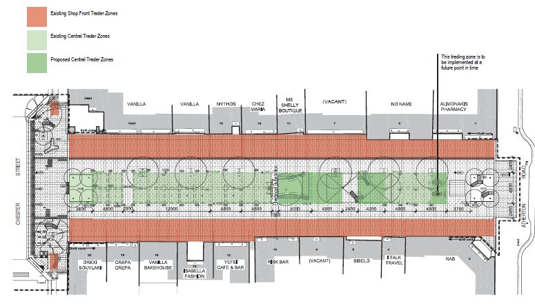
Attachment Three

                                                                           Index
PART ONE - FOOTPATH TRADING AND ACCESS POLICY .......................................................................... 3
1.    OVERVIEW ................................................................................................................................................. 3
2.    PERMITS FOR FOOTPATH TRADING ...................................................................................................... 5
3.    ENFORCEMENT OF PERMIT CONDITIONS............................................................................................. 7
PART TWO - EATON MALL FOOTPATH TRADING AND ACCESS POLICY ............................................... 28
4.    OVERVIEW ............................................................................................................................................... 28
5.    PERMITS FOR FOOTPATH TRADING .................................................................................................... 30
6.    ENFORCEMENT OF PERMIT CONDITIONS........................................................................................... 32
ANNEXURE A – EATON MALL TRADING PLAN ........................................................................................... 33

[6446527: 20823992_1]                                                                                                                               2
Attachment Three
PART ONE - FOOTPATH TRADING AND ACCESS POLICY
1. OVERVIEW
1.1 Purpose of the Policy
Traditionally, public footpaths have been provided to facilitate the safe passage of
pedestrians. Trends in more recent times by businesses in activity and neighbourhood
centres have been towards greater usage of footpaths to increase trading opportunities.
Council supports footpath trading so long as it contributes to the ambiance and vitality of a
centre. This support needs to be in balance with Council’s duty of care for the safety of the
public in general, particularly pedestrian safety.
The purpose of this Policy is to facilitate footpath trade within the City of Monash that
does not obstruct pedestrian access or create an unsafe or unsightly environment.
Council recognises the importance of footpath trading in contributing to the vitality of
commerce within the municipality.
1.2 Council’s vision for outdoor trading areas
Council wishes to foster the development and continued improvement of vibrant and
welcoming communities within its municipal district. It encourages the use of outdoor
trading areas by local businesses for this purpose. It is Council’s intention that outdoor
trading areas will be utilised to attract visitors and create welcoming family environments.
Where a local business wants to make use of an outdoor trading area, Council, in assessing
these requests, will ensure that traders contribute to the local atmosphere and vitality and
engage in uses that are complimentary to the existing use being made of nearby outdoor
trading areas.
For example, where an outdoor trading area is in an area predominantly used for al fresco
dining, Council will require a trader to make food available for consumption in such areas
at all times. Consistent with the Tobacco Act 1987, as long as food is commercially
available, smoking will be prohibited.
1.21.3 What the Policy applies to
This Policy applies to the following types of footpath uses associated with premises within
the City of Monash with the exception of Eaton Mall, Oakleigh (unless stated otherwise)
which is dealt with in Part Two of this Policy:
Tables and chairs
Windbreaks
Umbrellas
[6446527: 20823992_1] 3Attachment Three
Heaters
Display and sale of goods
Portable advertising boards, signs and flags
Temporary structures (including Eaton Mall)
1.31.4 Where the Policy applies
This Policy applies to all footpaths and activity and neighbourhood centres within the
municipality with the exception of Eaton Mall Oakleigh (unless stated otherwise) and
including but not limited to the activity and neighbourhood centres listed in the
appendices.
1.41.5 Objectives of the Policy
Pedestrian safety, and the use of Council assets for purposes that contribute to the
surrounding environment, is are primary concerns for footpath use. This Policy has been
developed with this in mind.
Council is committed to ensuring good access for people to move along footpaths, and to
enter and exit businesses. At a minimum, Council, through this Policy, aims to meet the
requirements of the Disability Discrimination Act (1992) (Cth) (Discrimination Act) and the
Advisory Notes on Access to Premises published by the Australian Human Rights
Commission (Advisory Notes).
In relation to footpath trading, the most important principles are to:
provide a continuous accessible path of travel (an accessible footpath is
considered to be one that people with a range of disabilities are able to use
without encountering barriers);
design and arrange elements in the streetscape that provide a continuous path
of travel; and
manage and maintain pedestrian access features; and
ensure that the use of footpaths and associated areas for business purposes
contributes positively to the amenity of the surrounding environment.
The objective of this Policy is to provide safe and unencumbered pedestrian access while
allowing footpath trading where conditions are assessed as suitable and safe for these
market-based activities.
1.51.6 Guiding Principles of the Policy
[6446527: 20823992_1] 4Attachment Three
1.5.11.6.1 Council aims to provide clear, safe and unobstructed access at all times for
pedestrians of all abilities on footpaths, in accordance with Council’s statutory
responsibilities.
1.5.21.6.2 Footpath trading activity must relate, and make a positive contribution, to the
character and amenity of the immediate and surrounding areas.
1.5.31.6.3 Council strongly supports the long-term viability and sustainability of activity and
neighbourhood centres.
1.5.41.6.4 Council acknowledges the importance of footpath trading in enhancing the
amenity, vitality and safety.
1.5.51.6.5 Footpath trading is a privilege, not a right.
1.61.7 Special Events
This Policy does not apply to special events, such as festivals or street parties, organised
and held by traders in with Council's permission. Traders wishing to hold such special
events will require a separate permit, to be administered by Council.
1.7 Temporary Structures
These may be permissible at the discretion of Council upon application. A license
agreement may be entered into subject to standard conditions including insurance
provisions and an initial $1,000 fee with a renewal fee of $200 (or as otherwise provided). A
relevant trading permit along with compliance with conditions will be taken into account in
determining an approval.
2. PERMITS FOR FOOTPATH TRADING
2.1 Management of Footpath Trading
Where a person intends to use a footpath for a purpose listed under cl 1.2 of this Policy,
they are required to obtain Council's permission to do so.
For this purpose, Council will receive and consider requests for permits under Council's
Local Law No 3 – Community Amenity (Local Law) which will allow the non-exclusive
occupation of defined areas within the municipality. Permits will be granted subject to
such terms and conditions as Council sees fit. Terms and conditions may vary between
permits, at Council's absolute discretion.
2.2 Permit Assessment Criteria
Applications for permits will be considered and determined in accordance with the
Local Law and this Policy. Permits will only be issued to traders where sufficient space
[6446527: 20823992_1] 5Attachment Three
exists to allow the requested usage to be properly and safely provided for, keeping in mind
Council's obligations under the Discrimination Act and Advisory Notes.
2.3 Decision making by Council
In accordance with clause 184 of the Local Law, when considering an application for a
permit, Council may consider any:
2.3.1 policy or guideline adopted by Council relating to the subject matter of the
application for the permit;
2.3.2 submission that may be received in respect of the application;
2.3.3 comments that may be made in respect of the application by any public body,
community organisation or other person; and
2.3.4 other relevant matter.
The following matters may also be considered by Council in assessing an application for a
permit, having regard to the available footpath area and local conditions:
2.3.5 whether the proposal has the potential to compromise pedestrian or traffic
safety, or public amenity or otherwise impact negatively on the functionality of a
footpath, roadway, car parking space, loading bay, public amenity and/or asset or
the like;
2.3.6 the visual impact of the proposal, including the potential to create visual clutter or
poor street image (especially in the case of display of goods);
2.3.7 the potential amenity impacts of the proposal, including the cumulative impact of
footpath trading on nearby occupancies;
2.3.8 whether a condition restricting trading or display hours is warranted, having
regard to matters such as the use and development of surrounding land, the
location of the footpath trading, the nature of the use of the footpath and any
management conditions including the hours of operation of nearby commercial
premises;
2.3.9 the interaction between the proposed use of the footpath area, including the
interaction between proposed structures and existing built form;
2.3.10 the nature, design, layout and function of the proposed structures and associated
land use; and
2.3.11 any impacts on other public land or public infrastructure/assets having regard to
the available footpath area and local conditions.
2.4 Discretion
An appropriately delegated officer may use their discretion to determine:
[6446527: 20823992_1] 6Attachment Three
2.4.1 whether the permit should be granted or refused; and
2.4.2 the terms and conditions appropriate for the relevant permit, if the permit is
granted, having regard to any relevant operational guidelines.
An application may be approved by Council as submitted, or approved subject to
modifications. A permit may also be subject to conditions imposed at Council’s discretion.
It will be a condition of every permit that the Local Law is complied with at all times.
Where a permit is granted, the permit may allow non-exclusive occupation in a form that
differs from that originally applied for. For example, it might:
2.4.3 vary the number of tables and chairs to be placed in the permit area;
2.4.4 require any furniture to be designed differently from that contemplated by the
application;
2.4.5 impose additional terms and conditions with respect to the maintenance of the
permit area; or
2.4.6 such other matters as Council sees fit.
3. ENFORCEMENT OF PERMIT CONDITIONS
3.1 Council's Obligations
Where Council issues a permit under the Local Law and this Policy, it will monitor
compliance with the Local Law and any permit conditions to ensure that traders are
complying with their obligations under both.
Where Council observes any non-compliance, it will act to achieve compliance, having
regard to, among other things, the impact that any non-compliance has, or might have, on
the safety of pedestrians and traders, access to and egress from the general area and
adjoining businesses and the general amenity of the area.
3.2 Enforcement of Non-compliance
Where Council observes any non-compliance, it will generally, having regard to the matters
outlined above, adopt the following escalating approach to enforcement, according to the
number of non-compliances observed of a particular trader:
3.2.1 First non-compliance – verbal warning coupled with education. Details of any
warning will be kept on Council's files.
3.2.2 Second non-compliance – issue a Notice to Comply under the Local Law.
[6446527: 20823992_1] 7Attachment Three
3.2.3 Third non-compliance – issue an infringement notice, either in respect of a failure
to comply with a Notice to Comply or a non-compliance that Council regards as
serious.
3.2.4 Fourth non-compliance – prosecution for an offence against the Local Law.
3.2.5 Fifth non-compliance – cancellation of permit.
Council may also, at any time, take steps to impound items used by traders found to be in
breach of the Local Law or their permit conditions.
Whether Council follows each of these steps on a particular occasion is entirely at Council's
discretion. Council may depart from the above at any time.
[6446527: 20823992_1] 8Attachment Three
APPENDIX A
GLEN WAVERLEY ACTIVITY CENTRE
A1 Application
This appendix applies to the Glen Waverley Activity Centre. Footpaths included are:
Kingsway Bogong Avenue to O’Sullivan Road (both sides)
Montclair Avenue Kingsway to laneway at rear of Kingsway (West) shops (both
sides)
Coleman Parade Springvale Road to laneway at rear of Kingsway (West) shops
(South side only)
Railway Parade North Springvale Road to Euneva Avenue
(North side only)
O’Sullivan Road Springvale Road to Kingsway
(South side only)
Springvale Road O’Sullivan Road to Railway Parade North
(West side only)
[6446527: 20823992_1] 9Attachment Three
A2 Footpath Appraisal
The following appraisal has been conducted to determine the zone configuration for Glen Waverley
Activity Centre.
Aspect Assessment
Parking Style 60º angle parking in
Kingsway, both sides – Bogong Avenue to Coleman Parade &
Coleman Parade, south side – Springvale Road to Kingsway
Parallel parking in all other locations where parking is permitted
Traffic Conditions
Road Classification Springvale Road – Arterial
Volumes All others - Local
Springvale Road – Heavy
Speed All others – Moderate
O’Sullivan Road – All roads within the Glen Waverley Activity Centre
Vehicle Type precinct are limited to 40 kph in parts of Sneddon Drive, O’Sullivan
Road, Railway Parade North, Coleman Parade and Kingsway.
Springvale Road – Mixed including heavy through traffic
Railway Parade North – Mixed including heavy bus traffic to station
terminal
All others – Mainly light vehicles & delivery vehicles
Kerb Profile Rollover type throughout
Pedestrian Traffic Heavy (Kingsway) to moderate in other locations
Footpath Widths Varies from 2.85 to 5.6 metres
Building Alignment Regular
Social & Cultural Strong entertainment hub
Significance Growing alfresco dining style and Chinese influence
A3 Footpath Space Allocation
Following appraisal, the following footpath space allocation has been adopted for Glen Waverley
Activity Centre:
Building line
Pedestrian Zone
Trading Zone
Kerbside Zone
Table A1 sets out the allocation of footpath space in the Glen Waverley Activity Centre.
[6446527: 20823992_1] 10Attachment Three
Table A1 - GLEN WAVERLEY ACTIVITY CENTRE
FOOTPATH SPACE AND ZONE ALLOCATIONS
Limits Zone Widths (m)
Parking Type
No. of Shop
Width (m)
Footpath
(maximum)
Pedestrian
Fronts
Kerbside
Road Side
Trading
Street Nos. (inclusive)
Kingsway to Railway Nil 0 3.00 Subject to
North
Station walkway redevelopment
Springvale Rd to Kingsway
No. 193 Nil 1 2.95 1.8 0.55 0.8
Coleman Parade
No. 187-191 Nil 2 2.95 1.8 0.55 0.8
South
No. 163-185 60A 14 3.25 1.6 0.6 0.9
63 Kingsway to right-of-
way Nil 2 4.2 2.0 1.2 1.0
O’Sullivan Road to Railway P 10 3.15 1.8 0.55 0.8
Pd North (No. 2-36)
East
Coleman Parade to Civic 60A 26 4.6 2.1 1.6 0.9
Centre (No. 62–110)
O’Sullivan Rd to Railway P 1 3.6 1.8 1.0 0.8
Kingsway
Parade North (No. 5)
Railway Parade North to Nil 9 6.6 Subject to
West
Coleman Parade redevelopment
Coleman Parade to Bogong
Avenue (No. 63-113) 60A 25 4.6 2.1 1.6 0.9
87 Kingsway to right-of- Nil 0 4.1 1.5 1.8 0.8
North
way
Montclair Av
89 Kingsway to right-of- P 1 3.9 1.5 1.6 0.8
South
way
Springvale Road to right-of- P 3 5.6 1.8 2.8 1.0
way (No. 56-60)
O’Sullivan Rd South
Glenway Arcade to Nil 3 5.5 1.8 1.8 1.9
Kingsway
Springvale Rd to right-of- P 8 3.5 1.5 1.2 0.8
way
(No. 55-75)
Right-of-way to 36 Nil 1 2.9 1.5 0.6 0.8
Kingsway
Railway Pd North North
Kingsway to Euneva 60A 6 3.7 1.5 1.2 1.0
Avenue
(No. 15–37A)
[6446527: 20823992_1] 11Attachment Three
Nil 2 4.0 Subject to
South
Kingsway to Bus Terminal redevelopment
O’Sullivan Rd to right-of-
way
No. 245-249 Nil 3 4.9 1.5 2.2 1.2
No. 251-261 Nil 6 4.9 1.5 2.2 1.2
Springvale Rd West No. 263 P 1 2.85 1.5 0.55 0.8
No. 265 P 2 3.2 1.5 0.9 0.8
No. 265A P 2 3.1 1.5 0.8 0.8
Right of way to Railway Pd P 3 2.9 1.5 0.6 0.8
North (No. 267-269)
Legend: Parking Types: 60A = 60 degree angle parking
90A = 90 degree angle parking
P = Parallel parking
Nil = No Standing zone
[6446527: 20823992_1] 12Attachment Three
APPENDIX B
OAKLEIGH ACTIVITY CENTRE
B1 Application
This appendix applies to the Oakleigh Activity Centre. Footpaths included are:
Atherton Road Jones Street to Clyde Street (north side)/Downing Street (south side)
Chester Street Jones Street to Hanover Street
Hanover Street Atherton Road to right-of-way south of Portman Street
Oxford Street Atherton Road to Carpark (east side)
Portman Street Chester Street to Hanover Street
Station Street Atherton Street to Portman Street
B2 Footpath Appraisal
The following appraisal has been conducted to determine the zone configuration for Oakleigh
Activity Centre.
Aspect Assessment
Parking Style Parallel parking in all locations where parking is permitted
Traffic Conditions
Road Classification Atherton Road – Arterial
Volumes All others - Local
Atherton Road & Hanover Street – Heavy
Speed All others – Moderate
Vehicle Type 50kph
General light to medium vehicles & delivery vehicles
Moderate bus traffic to bus terminal in Portman Street
Kerb Profile Standard type throughout with exception of Station Street (brick invert
with bollards)
Pedestrian Traffic Heavy to moderate in other locations
Footpath Widths Varies from 2.4 to 4.1 metres
Building Alignment Irregular in a number of locations
Social & Cultural Strong cultural hub
Significance Significant numbers of alfresco dining venues
B3 Footpath Space Allocation
Following appraisal, the following footpath space allocation has been adopted for Oakleigh Activity
Centre:
Building Line
Trading Zone
Pedestrian Zone
Kerbside Zone
Table B1 sets out the allocation of footpath space in the streets within Oakleigh Activity Centre.
[6446527: 20823992_1] 13Attachment Three
Table B1 OAKLEIGH ACTIVITY CENTRE
FOOTPATH SPACE AND ZONE ALLOCATIONS
No. of Shop Fronts
Limits Zone Widths (m)
Footpath Width
Parking Type
Pedestrians
(maximum)
Road
Kerbside
Side
Trading
(m)
Street Nos. (inclusive)
7 (Drummond Street-41 (Palmerston P 12 3.60 1.8 1.0 0.8
Grove)
North
43-55 (Atkinson Street) P 6 4.30 1.8 1.5 0.8
63-103 P 10 3.80 1.5 1.5 0.8
2 (Jones Street)-10A (Station Street) P 9 3.95 1.8 1.35 0.8
12 (Station Street)-24 (Eaton Mall) Bus 11 3.95 to 1.8 1.15 1.0
&P 3.65 to
Atherton Road 0.85
2 Eaton Mall-34A (ROW) P 8 3.75 1.8 1.15 0.8
South 36-44 P 4 3.9 to 1.8 1.1 to 0.8
3.05 Nil
46-50 P 4 2.85 1.8 Nil 0.8
52 P 5 2.80 1.8 Nil 0.8
56 (Hanover Street) P 1 2.95 1.8 Nil 0.8
66 (Car park)-82 (Downing Street) P 6 2.95 1.5 0.65 0.8
22 Station Street P 1 2.85 1.5 Nil 0.8
13-17D P 6 4.10 1.5 1.8 0.8
Chester Street North 17 Eaton Mall P 1 2.60 1.5 Nil 0.8
18 Eaton Mall P 1 2.70 1.5 Nil 0.8
33A (Car park)-45 (Hanover Street) P 7 3.85 1.5 0.65 0.8
24 Station Street P 1 2.50 1.5 Nil 0.8
12 P 1 4.10 1.5 1.8 0.8
18B-23 Eaton Mall P 2 3.20 1.5 0.9 0.8
Chester Street South
22 Eaton Mall P 1 2.75 1.5 Nil 0.8
22-28 P 8 3.55 1.5 1.25 0.8
30-32 P 2 4.00 1.5 1.25 0.8
23-72 Portman Street Nil 6 3.10 1.5 0.8 0.8
Hanover
West 45 Chester Street Nil 1 4.30 1.5 0.7 0.8
Street
56 Atherton Road Nil 1 3.00 1.5 0.7 0.8
Oxford Street East 2 P 1 3.1 1.5 0.8 0.8
[6446527: 20823992_1] 14Attachment Three
No. of Shop Fronts
Limits Zone Widths (m)
Footpath Width
Parking Type
Pedestrians
(maximum)
Road
Kerbside
Side
Trading
(m)
Street Nos. (inclusive)
Chester Street to Station Street Bus 2 3.55 2.55 Nil 1.0
5 (Station Street) P 5 2.60 1.5 Nil 0.8
7A-15 P 2 2.80 1.5 0.5 0.8
17 P 1 2.60 1.5 Nil 0.8
North 19-21 P 2 3.60 1.5 1.3 0.8
23-27 (Eaton Mall) P 4 2.60 1.5 Nil 0.8
36 Eaton Mall Bus 1 2.60 1.8 Nil 0.8
Portman 29-35 P 4 3.70 1.5 1.4 0.8
Street
37-45 P 6 2.40 1.5 Nil 0.8
51-59 P 5 3.70 1.5 1.4 0.8
18-36(Eaton Mall) P 9 2.70 1.5 Nil 0.8
38(Eaton Mall) -42A P 4 2.60 1.5 Nil 0.8
44(Shopping Centre)-56 P 3 4.15 1.5 1.35 0.8
South
56A-58B P 5 3.60 1.5 1.3 0.8
60-66 P 5 2.75 1.5 Nil 0.8
68-72 P 5 3.60 1.5 1.3 0.8
Atherton Road to 20 P 7 3.50 1.5 1.2 0.8
East 22 (Chester Street) P 1 2.40 1.5 Nil 0.8
Station Street
24- Portman Street P 5 2.40 1.5 Nil 0.8
West Atherton Road to Portman Street P 19 3.10 1.5 0.8 0.8
60A = 60 degree angle
Parking Types: parking
90A = 90 degree angle parking
P = Parallel parking
Nil = No Standing zone
[6446527: 20823992_1] 15Attachment Three
APPENDIX C
MOUNT WAVERLEY ACTIVITY CENTRE
C1 Application
This appendix applies to the Mount Waverley Activity Centre. Footpaths included are:
Hamilton Place Full length (both sides)
Hamilton Walk Hamilton Place to Winbourne Road (west side)
Stephensons Road Hamilton Place (north leg) to Virginia Street (both sides)
The Highway Stephensons Road to Gallery Place (north-east sides)
Winbourne Road Stephensons Road to Right of Way (south side)
C2 Footpath Appraisal
The following appraisal has been conducted to determine the zone configuration for Mount
Waverley Activity Centre.
Aspect Assessment
Parking Style 90º angle parking in Hamilton Place, east, south & west sides
60º angle parking in Hamilton Place-north side, Stephensons Road-
between 262 & 282, The Highway-north east side & Winbourne Road-
south side.
Parallel parking in all other locations where parking is permitted
Traffic Conditions
Road Classification Stephensons Road – Arterial
Volumes All others - Local
Stephensons Road – Heavy
Speed All others – Moderate
Stephensons Road – 60kph
Vehicle Type All others – 50kph
Stephensons Road – Mixed including heavy through traffic
All others – Mainly light vehicles & delivery vehicles
Kerb Profile Standard type throughout
Pedestrian Traffic Generally moderate
Footpath Widths Varies from 2.95 to 4.15 metres
Hamilton Walk (no vehicular traffic) – 7.70 metres
Building Alignment Regular
Social & Cultural Village-style suburban shopping centre
Significance Several alfresco dining venues
[6446527: 20823992_1] 16Attachment Three
C3 Footpath Space Allocation
Following appraisal, the following footpath space allocation has been adopted for Mount Waverley
Activity Centre:
Building line
Pedestrian Zone
Trading Zone
Kerbside Zone
Table C1 sets out the allocation of footpath space in the Mount Waverley Activity Centre.
Table C1 - MOUNT WAVERLEY ACTIVITY CENTRE
FOOTPATH SPACE AND ZONE ALLOCATIONS
Limits Zone Widths (m)
Parking Type
No. of Shop
Width (m)
Footpath
(maximum)
Pedestrian
Fronts
Kerbside
Road Side
Trading
Street Nos. (inclusive)
s
9 Hamilton Place (side Nil 3 4.20 1.5 1.9 0.8
boundary)
14 (side boundary)-right-of- Nil 3 4.15 1.5 1.85 0.8
North way
20(ROW)-30 (Stephensons 60A 3 4.60 1.5 2.1 to 1.0
Hamilton Place Road) to 0.65
3.15
East 2-14 90A 7 3.10 1.8 0.6 0.6
South 47-79 90A 17 3.95 1.8 0.95 1.2
1-9 90A 7 3.35 1.8 0.6 0.6
West
13-45 90A 11 4.15 1.8 1.15 1.2
Hamilton Walk West 1-11 Nil 6 7.70 1.8 Verify 0
262 (Winbourne Road) to 282 60A 9 3.15 1.5 0.65 1.0
East (The Highway)
284-316 P 19 3.30 1.5 0.8 1.0
Stephensons
Road 79 Hamilton Pl (side Nil 2 3.10 1.8 0.8 0.5
boundary)
West
303 (Winbourne Road) to 327 P 14 4.00 1.5 1.5 1.0
(Virginia Street)
The Highway N/E 2-12 60A 7 3.50 1.5 1.0 1.0
Winbourne 303 Stephensons Rd (side 60A 3 2.95 1.5 Nil 1.0
South
Road boundary)
[6446527: 20823992_1] 17Attachment Three
APPENDIX D
PINEWOOD ACTIVITY CENTRE
D1 Application
This appendix applies to the Pinewood Activity Centre. Footpaths included are:
Blackburn Road No. 471 to 71 Centreway (west side)
Centreway All (all sides)
D2 Footpath Appraisal
The following appraisal has been conducted to determine the zone configuration for Pinewood
Activity Centre.
Aspect Assessment
Parking Style 90º angle parking in Centreway-north side (47 to 69)
60º angle parking in Blackburn Road - west side (425 to 71
Centreway), east side and west side
Parallel parking in all other locations where parking is permitted
Traffic Conditions
Road Classification All local roads
Volumes
Moderate to light
Speed
50kph
Vehicle Type
Mainly light vehicles & delivery vehicles
Kerb Profile Standard type throughout
Pedestrian Traffic Generally light to moderate
Footpath Widths Varies from 2.0 to 3.2 metres
5.45 metres in front of 25 & 27 Centreway
Building Alignment Generally regular
Social & Cultural Village-style suburban shopping centre
Significance Several alfresco dining venues
D3 Footpath Space Allocation
Following appraisal, the following footpath space allocation has been adopted for Pinewood
Activity Centre:
Building Line
Pedestrian Zone
Trading Zone
Kerbside Zone
Table D1 sets out the allocation of footpath space in the streets within Pinewood Activity Centre.
Table D1 PINEWOOD ACTIVITY CENTRE
[6446527: 20823992_1] 18Attachment Three
FOOTPATH SPACE AND ZONE ALLOCATIONS
Limits Zone Widths (m
Parking Type
No. of Shop
Width (m)
Footpath
(maximum)
Pedestrian
Fronts
Kerbside
Road Side
Trading
Street Nos. (inclusive)
s
Blackburn Road 425-71 Centreway 60A 12 3.00 1.5 0.5 1.0
West
(Service Road) 407 P 4 2.00 1.5 Nil 0.5
2 (frontage) Nil 2 2.3 1.5 Nil 0.8
24-30 P 4 2.5 1.5 Nil 1.0
South
32 Nil 1 2.6 1.5 Nil 0.8
34-38 Nil 3 2.9 1.5 0.6 0.8
47 (side boundary) 60A 2 3.00 1.5 0.5 1.0
East
Centreway right-of-way to 2 60A 2 2.30 1.5 Nil 0.8
47-69 (right-of-way) 90A 12 3.2 1.5 0.7 1.0
North
71 P 2 3.2 1.5 0.9 0.8
1-23 60A 9 3.20 1.5 0.7 1.0
West 25-27 (Walkway) 60A 2 5.45 1.5 Verify 1.0
29 (Walkway) to Theatre 60A 9 3.2 1.5 0.7 1.0
[6446527: 20823992_1] 19Attachment Three
APPENDIX E
CLAYTON ACTIVITY CENTRE
E1 Application
This appendix applies to the Clayton Activity Centre. Footpaths included are:
Carinish Road Rights-of-way west of 309 Clayton Road to Mary Street
Clayton Road Railway line to Centre Road
Dunstan Street Rights-of-way west of Clayton Road to Clayton Road
Haughton Road Clayton Road to rights-of-way east of Clayton Road
E2 Footpath Appraisal
The following appraisal has been conducted to determine the zone configuration for Clayton
Activity Centre.
Aspect Assessment
Parking Style A mix of 45º angle & parallel parking
Traffic Conditions
Road Classification Clayton Road – Arterial
Volumes All others - Local
Clayton Road – Heavy
Speed Carinish Road, Haughton Road & Dunstan Street – Moderate to heavy
Clayton Road – 40kph – during trading hours
Vehicle Type All others – 50kph
Clayton Road – Mixed including heavy through traffic
All others – Mainly light to medium & delivery vehicles
Kerb Profile Standard type throughout
Pedestrian Traffic Heavy to moderate
Footpath Widths Varies from 2.6 to 8.3 metres
Building Alignment Irregular in a number of locations
Social & Cultural Strong cultural hub
Significance Several alfresco dining venues
E3 Footpath Space Allocation
Following appraisal, the following footpath space allocation has been adopted for Clayton Activity
Centre:
Building Line
Pedestrian Zone
Trading Zone
Kerbside Zone
Table E1 sets out the allocation of footpath space in the streets within Clayton Activity Centre.
[6446527: 20823992_1] 20Attachment Three
Table E1 - CLAYTON ACTIVITY CENTRE
FOOTPATH SPACE AND ZONE ALLOCATIONS
Limits Zone Widths (m)
Parking Type
No. of Shop
Width (m)
Footpath
(maximum)
Pedestrian
Fronts
Kerbside
Road Side
Trading
Street Nos. (inclusive)
s
123 (Clayton Road) to 151 P 19 3.50 1.5 1.2 0.8
Carinish Road North
309 Clayton Road Westerly Nil 3 4.15 1.5 1.85 0.8
276-280 (Haughton Road) Nil 3 2.6 1.8 Nil 0.6
282 (Haughton Road)-294 Nil 8 2.6 1.8 Nil 0.6
(righright-of-way)
296-312A Bus 11 5.35 2.95 Nil 2.4
314-324 45A 8 5.5 1.8-2.1 2.1-2.4 1.3
324A-328A P 3 5.45 1.8-2.1 2.15- 1.3
2.35
330-332A Nil 5 8.3 5.5 Nil 2.8
Clayton Road East 334-334A Nil 2 8.3 1.8-2.1 Verify 2.8
336-340 45A 5 4.05 1.8-2.1 Verify 1.3
340A-346 45A 5 5.5 1.8-2.1 Verify 1.3
346A 45A 2 4.0 1.8-2.1 Verify 1.3
348-350A P 3 4.0 1.8-2.1 Verify 0
352 Nil 1 3.8 to 1.8 Verify 0.8
5.3
354-362 Nil 5 5.3 1.8 Verify 0.8
364-368 (Centre Road) Nil 3 3.9 1.8 Verify 1.2
299 to 309 Nil 14 4.3 1.5 2.0 0.8
317 (Haughton Road)-331 Nil 5 3.1 to 1.8 Verify 0.8
3.4
333A-337 P 6 7.1 to 1.8 Verify 0.8
6.3
337A Nil 1 2.25 1.8 Nil 0.6
339-343 (Dunstan Street) Nil 3 8.35 1.8 Verify 0.6
Clayton Road West 345 (Dunstan Street)-349 Bus 5 5.75 3.45 Nil 2.3
351 Bus 1 5.75 3.45 Nil 2.3
to 4.1
353-355 Nil 2 4.1 1.8-2.1 1.3-1.0 1.0
357-367 45A 13 4.1 1.8-2.1 1.3-1.0 1.0
369 (Arcade) -373C Nil 4 4.1 2.1 Nil 2.0
375-381 P 5 3.85 1.8 1.05 1.0
383-407 45A 13 3.85 1.8 1.05 1.0
Dunstan Street North 35-47 (Clayton Road) P 8 3.4 1.8 0.6 1.0
[6446527: 20823992_1] 21Attachment Three
Limits Zone Widths (m)
Parking Type
No. of Shop
Width (m)
Footpath
(maximum)
Pedestrian
Fronts
Kerbside
Road Side
Trading
Street Nos. (inclusive)
s
South Clayton Road to right-of-way P 2 2.7 1.8 Nil 0.9
Haughton Road South Clayton Road to right-of-way Nil 1 2.7 1.8 Nil 0.8
[6446527: 20823992_1] 22Attachment Three
APPENDIX F
NEIGHBOURHOOD CENTRES
F1 Application
This appendix applies to the Neighbourhood Centres listed.
Mount
Andrew Street Waverley East side, Highbury Road to No. 20
Atkinson Street Chadstone West side, No. 41 to No. 51
Mount
Barlyn Road Waverley North side, Huntingdale Road to No. 13
Batesford Road Chadstone North side, No 43 to Power Avenue
Mount
Bellerive Avenue Waverley South side, No. 14 to Stephensons Road
Glen
Blackburn Road Waverley East side, High Street Road to No. 268
Mount
Blackburn Road Waverley West side, No. 187 to High Street Road
Mount
Blackburn Road Waverley West side, Lucerne Street to No. 71
Wheelers
Brandon Park Drive Hill North side, Lum Road to Ondine Drive
Centre Road Clayton North side, No. 1457 to Kionga Street
Clayton Road Clayton East side, No. 162 to Myriong Street
West side, High Street Road to Mavron
Cleveland Road Ashwood Street
Glen South side, Blackburn Road to Fiander
Coleman Parade Waverley Avenue
Dunoon Court Mulgrave West side, No. 1 to No. 8
Mount
Essex Road Waverley North side, No. 3 to No. 13
Mount
Essex Road Waverley South side, No. 54 to Surrey Road
Ferntree Gully Road Notting Hill South side, Blackburn Road to No. 414
Glen
Glenwood Avenue Waverley West side, Waverley Road to No. 11
Hansworth Street Mulgrave South side, Einstein Avenue to No. 124
Hennessy Street Chadstone West side, Rae Street to No. 51
High Street Road Ashwood North side, No. 207 to Raymond Street
Mount
High Street Road Waverley North side, Leeds Street to No. 513
Mount North side, Larch Crescent to Blackburn
High Street Road Waverley Road
Glen South side, No. 678 to No. 710 (Myers
High Street Road Waverley Avenue)
Highbury Road Burwood South side, Evens Street to No. 58
[6446527: 20823992_1] 23Attachment Three
Huntingdale Road Chadstone West side, Railway Parade to No. 277
Huntingdale Road Huntingdale East side, No. 186 to Dandenong Road
Huntingdale Road Huntingdale East side, Leigh Street to Greville Street
Huntingdale Road Huntingdale East side, Hargreaves Street to North Road
Mount
Huntingdale Road Waverley East side, No. 412 to Waverley Road
Huntingdale Road Oakleigh West side, No. 271 to Railway Avenue
Johnson Street Oakleigh East side, Haughton Road to Mora Avenue
Kangaroo Road Hughesdale North side, No. 113 to Dalston Road
Glen East side, High Street Road to No. right-of-
Kerrie Road Waverley way
Oakleigh
Lawson Street East South side, No. 2 to Oberon Avenue
Mackie Road Mulgrave North side, Medora Grove to No. 81
Oakleigh
Macrina Street East East side, Macrina Avenue to No. 4
Mount
Marianne Way Waverley West side, Jacqueline Road to No. 61
Mount
McLochlan Street Waverley North side, No.15 to No. 25
Poath Road Hughesdale East side, Paget Street to Arthur Street
North-east side, Clayton Road to Glenbrook
Dandenong Road Clayton Avenue
Glen
Springvale Road Waverley West side, Frank Street to No. 373
Springvale Road Mulgrave West side, Wilma Avenue to No. 903
Mount
Stanley Avenue Waverley West side, No. 49 to Ian Grove
Vannam Drive Ashwood West side, No. 35 to No. 45
Glen
Viewpoint Avenue Waverley West side, No. 39 to Waverley Road
Mount
Wadham Parade Waverley West side, No. 47 to Miller Crescent
Wanda Street Mulgrave East side, No. 38 to No. 50 (right-of-way)
East side, Douglas Street to High Street
Warrigal Road Ashwood Road
Warrigal Road Chadstone East side, Railway line to Batesford Road
Warrigal Road Chadstone East Side, Waverley Road to Tuhan Street
Warrigal Road Hughesdale West side, Railway line to No. 103
Warrigal Road Oakleigh East side, No. 140 to Schoolhall St
Warrigal Road Oakleigh East side, No. 170 to North Road
Mount
Waverley Road Waverley North side, No. 169 to No. 171
Mount
Waverley Road Waverley North side, No. 335 to Stephensons Road
Glen
Waverley Road Waverley North side, Dominion Avenue to No. 869
[6446527: 20823992_1] 24Attachment Three
Westerfield Road Notting Hill West side, No. 39 to No. 49
Willesden Road Hughesdale North side, Poath Rd to No. 21
Glen
Willow Avenue Waverley South side, Medina Road to No. 48
Yertchuk Avenue Ashwood Both sides, Arthur Street to Nos. 19/22
F2 Footpath Appraisal
The following appraisal has been conducted to determine the zone configuration for
Neighbourhood Centres.
Aspect Assessment
Parking Style Mostly angle parking in parking setbacks
Traffic Conditions
Road Classification Mostly local roads
Volumes Generally moderate to light
Speed 50-60kph
Vehicle Type Mostly light to medium vehicles & delivery vehicles
Kerb Profile Standard type throughout
Pedestrian Traffic Generally light
Footpath Widths Varies
Building Alignment Generally regular
Social & Cultural Local shopping strip
Significance Generally have one or more takeaway food shops and occasional
alfresco dining venues
F3 Footpath Space Allocation
Following appraisal, the following footpath space allocation has been adopted for Neighbourhood
Centres:
Building Line
Pedestrian Zone
Trading Zone
Kerbside Zone
Table F1 sets out the allocation of footpath space in these centres.
[6446527: 20823992_1] 25Table F1 – NEIGHBOUHOOD CENTRES
FOOTPATH SPACE AND ZONE ALLOCATIONS
Limits Zone Widths (m)
No. of Shop Fronts
Parking Type
Footpath Width
(maximum)
Pedestrian
Kerbside
Road Suburb
Trading
(m)
Street Nos.
(inclusive)
Andrew Street Mount Waverley 2 to 20 60A 10 4.25 1.5 1.75 1.0
Atkinson Street Chadstone 41 to 51 60A 6 4.10 1.5 1.60 1.0
Barlyn Road Mount Waverley 1 to 13 90A 7 3.20 1.5 0.70 1.0
Batesford Road Chadstone 43 to 53 75A 6 3.20 1.5 0.70 1.0
Bellerive Avenue Mount Waverley 14 to 22 90A 5 3.20 1.5 0.70 1.0
Blackburn Road Mount Waverley 47 to 71 60A 13 3.25 1.5 0.75 1.0
Blackburn Road Mount Waverley 187 to 197 60A 6 2.65 Nil
202 to 214 60A 7 3.70 1.5 1.20 1.0
Blackburn Road Glen Waverley
216 to 268 60A 24 3.60 1.5 1.10 1.0
Brandon Park Drive Wheelers Hill 200 to 212 Nil 6 5.80 1.8 4.00 0.0
Centre Road Clayton 1457 to 1485 60A 14 3.20 1.5 0.70 1.0
Clayton Road Clayton 162 to 176 P 9 3.20 1.5 1.10 0.6
Cleveland Road Ashwood 3 to 17 60A 9 4.30 1.5 1.80 1.0
Coleman Parade Glen Waverley 1 to 29 P 11 3.70 1.5 1.60 0.6
Dunoon Court Mulgrave 1 to 8 90A 9 3.10 1.5 0.60 1.0
Essex Road Mount Waverley 3 to 13 60A 6 3.10 1.5 0.60 1.0
Essex Road Mount Waverley 54 to 66 60A 7 4.20 1.5 1.70 1.0
Ferntree Gully Road Notting Hill 402 to 414 P 8 3.15 1.5 1.05 0.6
Glenwood Avenue Glen Waverley 1 to 11 60A 6 3.25 1.5 0.75 1.0
Hansworth Street Mulgrave 114 to 124 90A 5 3.20 1.5 0.70 1.0
Hennessey Street Chadstone 41 to 51 60A 5 3.65 1.5 1.15 1.0
High Street Road Ashwood 207 to 219 60A 4 3.15 1.5 0.65 1.0
High Street Road Mount Waverley 491 to 513 60A 12 3.60 1.5 1.10 1.0
613 to 625 P 5 2.05 Nil
High Street Road Mount Waverley
627 to 641 P 6 3.55 1.5 1.45 0.6
High Street Road Glen Waverley 678 to 710 60A 14 3.75 1.5 1.25 1.0
Highbury Road Burwood 56 to 58 P 2 2.70 1.5 Nil 0.8
Huntingdale Road Chadstone 265 to 277 60A 7 3.55 1.5 1.05 1.0
412 to 418 60A 5 3.20 1.5 0.70 1.0
Huntingdale Road Mount Waverley
420 to 430 P 7 3.40 1.5 1.30 0.6
186 to 190 90 A 8 3.85 1.5 1.35 1.0
Huntingdale Road Huntingdale
192 to 200 Zero 5 4.00 1.5 1.90 0.6
Huntingdale Road Huntingdale 240 to 248 60 A 9 3.90 1.5 1.40 1.0
276 to 286 90 A 12 6.10 1.8 3.30 1.0
Huntingdale Road Huntingdale
288 to 314 60 A 22 4.05 1.8 1.25 1.0
Huntingdale Road Oakleigh 271 to 323 P 27 3.80 1.8 1.40 0.6
Johnson Street Oakleigh 2 to 26 60A 9 3.50 1.5 1.00 1.0
[6446527: 20823992_1] 26 | P a g eLimits Zone Widths (m)
No. of Shop Fronts
Parking Type
Footpath Width
(maximum)
Pedestrian
Kerbside
Road Suburb
Trading
(m)
Street Nos.
(inclusive)
Kangaroo Road Hughesdale 113 to 127 P 8 4.35 1.5 2.25 0.6
Kerrie Road Glen Waverley 2 to 24 60A 10 3.95 1.5 1.45 1.0
Lawson Street Oakleigh East 2 to 16 90A 6 3.95 1.5 1.45 1.0
Mackie Road Mulgrave 71 to 81 60A 5 4.10 1.5 1.60 1.0
Macrina Street Oakleigh East 1 to 4 60A 7 3.15 1.5 0.65 1.0
Marianne Way Mount Waverley 47 to 61 60A 8 5.60 1.5 3.10 1.0
McLochlan Street Mount Waverley 15 to 25 60A 6 3.15 1.5 0.65 1.0
Poath Road Hughesdale 40 to 118 P 35 3.70 1.8 1.30 0.6
Dandenong Road Clayton 1895 to 1919 P 11 3.75 1.5 1.65 0.6
Springvale Road Glen Waverley 363 to 373 P 6 3.30 1.5 1.20 0.6
881 to 895 P 6 5.10 1.5 3.00 0.6
Springvale Road Mulgrave
897 to 903 90A 6 3.65 1.5 1.15 1.0
Stanley Avenue Mount Waverley 49 to 63 60A 8 3.80 1.5 1.30 1.0
Vannam Drive Ashwood 35 to 45 P 6 3.80 1.5 1.70 0.6
Viewpoint Avenue Glen Waverley 39 to 49 60A 6 4.05 1.5 1.55 1.0
Wadham Parade Mount Waverley 47 to 63 90A 9 3.65 1.5 1.15 1.0
Wanda Street Mulgrave 38 to 50 60A 8 4.50 1.5 2.00 1.0
481 to 487 60A 4 2.25 Nil
Warrigal Road Ashwood 489 to 509 60A 9 3.65 1.5 1.15 1.0
511 to 545 P 16 3.50 1.5 1.40 0.6
Warrigal Road Chadstone 617 to 655 P 20 3.55 1.5 1.45 0.6
Warrigal Road Chadstone 715 to 723 P 5 3.30 1.5 1.20 0.6
Warrigal Road Hughesdale 65 to 103 P 17 4.10 1.5 2.00 0.6
Warrigal Road Oakleigh 140 to 148 P 5 4.00 1.5 1.70 0.6
Warrigal Road Oakleigh 170 to 200 P 15 4.00 1.8 1.60 0.6
Waverley Road Mount Waverley 169 to 171 60A 3 3.10 1.5 0.60 1.0
Waverley Road Mount Waverley 335 to 361 P 8 3.65 1.5 1.55 0.6
Waverley Road Glen Waverley 861 to 869 60A 4 3.30 1.5 0.80 1.0
Westerfield Road Notting Hill 39 to 49 90A 6 3.40 1.5 0.90 1.0
Willesden Road Hughesdale 1 to 21 P 11 2.80 1.5 0.70 0.6
Willow Avenue Glen Waverley 28 to 48 60A 9 3.80 1.5 1.30 1.0
1 to 19 60A 10 3.20 1.5 0.70 1.0
Yertchuk Avenue Ashwood
2 to 22 60A 11 3.20 1.5 0.70 1.0
Legend: Parking Types: 60A = 60 degree angle parking
90A = 90 degree angle parking
P = Parallel parking
Nil = No Standing zone
[6446527: 20823992_1] 27 | P a g ePART TWO - EATON MALL FOOTPATH TRADING AND ACCESS POLICY
4. OVERVIEW
4.1 Purpose of the Policy
Traditionally, public footpaths have been provided to facilitate the safe passage of
pedestrians. Trends in more recent times by businesses in activity and
neighbourhood centres have been towards greater usage of footpaths to increase
trading opportunities.
Council supports footpath trading so long as it contributes to the ambiance and
vitality of a centre. This support needs to be in balance with Council’s duty of care for
the safety of the public in general, particularly pedestrian safety.
The purpose of this Policy is to facilitate footpath trade in Eaton Mall, Oakleigh
that does not obstruct pedestrian access or create an unsafe or unsightly
environment.
Council recognises the importance of footpath trading in contributing to the vitality
of commerce within Eaton Mall.
4.2 Council’s vision for Eaton Mall
Eaton Mall is locally and internationally renowned as a food destination, providing
predominantly Greek cuisine in an al fresco environment. The atmosphere and
vitality of Eaton Mall is entirely unique in Melbourne and Council is dedicated to
retaining that character.
Council’s vision for Eaton Mall is to protect, and continue to improve on, its renown.
It will do so by ensuring that traders in Eaton Mall continue to contribute to its
atmosphere and vitality, particularly by making food available for consumption in al
fresco areas at all times.
Consistent with the Tobacco Act 1987, as long as food is commercially available,
smoking will be prohibited.
4.24.3 What the Policy applies to
This Policy applies to the following types of footpath uses associated with premises in
Eaton Mall:
Tables and chairs
Windbreaks
Umbrellas
Heaters
Display and sale of goods
[6446527: 20823992_1] 28 | P a g e Portable advertising boards, signs and flags
4.34.4 Where the Policy applies
This Policy applies to the central footpath area of Eaton Mall, from private property
boundary to opposite private property boundary (see Eaton Mall Plan at Annexure A).
It also applies to the limited trading in the central area south of Portman Street
subject to clear unimpeded pedestrian access being maintained (see Portman Street
Plan at Annexure B).
4.44.5 Objectives of the Policy
Pedestrian safety, and the use of Council assets for purposes that contribute to the
surrounding environment, is are primary concerns for footpath use. This Policy has
been developed with this in mind.
Council is committed to ensuring good access for people to move along footpaths,
and to enter and exit businesses, within Eaton Mall. At a minimum, Council, through
this Policy, aims to meet the requirements of the Disability Discrimination Act (1992)
(Cth) (Discrimination Act) and the Advisory Notes on Access to Premises published
by the Australian Human Rights Commission (Advisory Notes).
In relation to footpath trading, the most important principles are to:
provide a continuous accessible path of travel (an accessible
footpath is considered to be one that people with a range of disabilities are
able to use without encountering barriers);
design and arrange elements in the streetscape that provide a continuous
path of travel; and
manage and maintain pedestrian access features; and
ensure that the use of footpaths and associated areas for business purposes
contributes positively to the amenity of the surrounding environment.
The objective of this Policy is to provide safe and unencumbered pedestrian access
in Eaton Mall while allowing footpath trading where conditions are assessed as
suitable and safe for these market-based activities.
4.54.6 Guiding Principles of the Policy
4.5.14.6.1 Council aims to provide clear, safe and unobstructed access at all times for
pedestrians of all abilities on footpaths in Eaton Mall, in accordance with
Council’s statutory responsibilities.
4.5.24.6.2 Footpath trading activity must relate, and make a positive contribution, to
the character and amenity of Eaton Mall and surrounding areas.
4.5.34.6.3 Council strongly supports the long-term viability and sustainability of Eaton
Mall as a retail strip and food destination.
[6446527: 20823992_1] 29 | P a g e4.5.44.6.4 Council acknowledges the importance of footpath trading in enhancing the
amenity, vitality and safety of Eaton Mall.
4.64.7 Special Events
This Policy does not apply to special events, such as festivals or street parties,
organised and held by traders in Eaton Mall with Council's permission. Traders
wishing to hold such special events will require a separate permit, to be administered
by Council in accordance with its Special Event Operational Guidelines.
5. PERMITS FOR FOOTPATH TRADING
5.1 Management of Footpath Trading
Where a person intends to use a footpath in Eaton Mall for a purpose listed under
cl 1.2 of this Policy, they are required to obtain Council's permission to do so.
For this purpose, Council will receive and consider requests for permits under
Council's Local Law No 3 – Community Amenity (Local Law) which will allow the non-
exclusive occupation of defined areas within Eaton Mall. Permits will be granted
subject to such terms and conditions as Council sees fit. Terms and conditions may
vary between permits, at Council's absolute discretion.
5.2 Permit Assessment Criteria
Applications for permits will be considered and determined in accordance with
the Local Law and this Policy. Permits will only be issued to traders where sufficient
space exists in Eaton Mall to allow the requested usage to be properly and safely
provided for, keeping in mind Council's obligations under the Discrimination Act and
Advisory Notes.
5.3 Decision making by Council
In accordance with clause 184 of the Local Law, when considering an application for a
permit, Council may consider any:
5.3.1 policy or guideline adopted by Council relating to the subject matter of the
application for the permit;
5.3.2 submission that may be received in respect of the application;
5.3.3 comments that may be made in respect of the application by any public
body, community organisation or other person; and
5.3.4 other relevant matter.
The following matters may also be considered by Council in assessing an application
for a permit, having regard to the available footpath area and local conditions:
5.3.5 whether the proposal has the potential to compromise pedestrian or traffic
safety, public amenity or impact negatively on the functionality of a
[6446527: 20823992_1] 30 | P a g efootpath, roadway, car parking space, loading bay, public amenity and/or
asset or the like;
5.3.6 the visual impact of the proposal, including the potential to create visual
clutter or poor street image (especially in the case of display of goods);
5.3.7 the potential amenity impacts of the proposal, including the cumulative
impact of footpath trading on nearby occupancies;
5.3.8 whether a condition restricting trading or display hours is warranted, having
regard to matters such as the use and development of surrounding land, the
location of the footpath trading, the nature of the use of the footpath and
any management conditions including the hours of operation of nearby
commercial premises;
5.3.85.3.9 whether a condition relating to the types of activities that may be conducted
is warranted, having regard to matters such as the nature of surrounding
businesses and the desirability of maintaining the atmosphere, character and
vitality of the surrounding area;
5.3.95.3.10 the interaction between the proposed and current use of the footpath
area, including the interaction between proposed structures and existing
built form;
5.3.105.3.11 the nature, design, layout and function of the proposed structures and
associated land use; and
5.3.115.3.12 any impacts on other public land or public infrastructure/assets having
regard to the available footpath area and local conditions.
5.4 Discretion
An appropriately delegated officer may use their discretion to determine:
5.4.1 whether the permit should be granted or refused; and
5.4.2 the terms and conditions appropriate for the relevant permit, if the permit is
granted, having regard to any relevant operational guidelines.
An application may be approved by Council as submitted, or approved subject to
modifications. A permit may also be subject to conditions imposed at Council’s
discretion. It will be a condition of every permit that the Local Law is complied with
at all times.
Where a permit is granted, the permit may allow non-exclusive occupation in a form
that differs from that originally applied for. For example, it might:
5.4.3 vary the number of tables and chairs to be placed in the permit area;
5.4.4 require any furniture to be designed differently from that contemplated by
the application;
[6446527: 20823992_1] 31 | P a g e5.4.5 impose additional terms and conditions with respect to the maintenance of
the permit area; or
5.4.6 such other matters as Council sees fit.
6. ENFORCEMENT OF PERMIT CONDITIONS
6.1 Council's Obligations
Where Council issues a permit under the Local Law and this Policy, it will monitor
compliance with the Local Law and any permit conditions to ensure that traders are
complying with their obligations under both.
Where Council observes any non-compliance, it will act to achieve compliance, having
regard to, among other things, the impact that any non-compliance has, or might
have, on the safety of pedestrians and traders, access to and egress from Eaton Mall
and adjoining businesses and the general amenity of the area.
6.2 Enforcement of Non-compliance
Where Council observes any non-compliance, it will generally, having regard to the
matters outlined above, adopt the following escalating approach to enforcement,
according to the number of non-compliances observed of a particular trader:
6.2.1 First non-compliance – verbal warning coupled with education. Details of
any warning will be kept on Council's files.
6.2.2 Second non-compliance – issue a Notice to Comply under the Local Law.
6.2.3 Third non-compliance – issue an infringement notice, either in respect of a
failure to comply with a Notice to Comply or a non-compliance that Council
regards as serious.
6.2.4 Fourth non-compliance – prosecution for an offence against the Local Law.
6.2.5 Fifth non-compliance – cancellation of permit.
Council may also, at any time, take steps to impound items used by traders found to
be in breach of the Local Law or their permit conditions.
Whether Council follows each of these steps on a particular occasion is entirely at
Council's discretion. Council may depart from the above at any time.
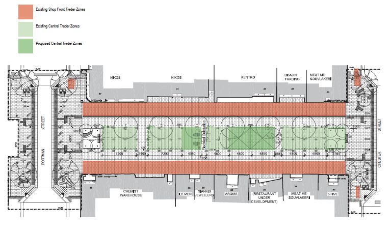
[6446527: 20823992_1] 32 | P a g eANNEXURE A – EATON MALL TRADING PLAN [6446527: 20823992_1] 33 | P a g e
[6446527: 20823992_1] 34 | P a g e
[6446527: 20823992_1] 35 | P a g e
[6446527: 20823992_1] 36 | P a g e
You can also read