T5.3 - National Stakeholder Coordination A Brief Survey of EO/GI in Algeria - M. Kaddour University of Oran 1 - SEED4NA
←
→
Page content transcription
If your browser does not render page correctly, please read the page content below
Spatial Data Infrastructure and Earth Observation Education and Training for North Africa

           T5.3 – National Stakeholder Coordination
               A Brief Survey of EO/GI in Algeria
                          Online meeting of 11/03/2021

                                  M. Kaddour
                              University of Oran 1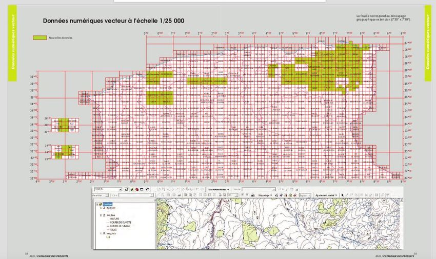
Spatial Data Infrastructure and Earth Observation Education and Training for North Africa

      Summary
      • Governance and Institutions
      • Main National Agencies
             • INCT
             • Cadaster
             • ASAL
      •   Standardization
      •   Activities of the UN-GGIM Arab States Committee
      •   Geospatial Education, Training and Capacity Building
      •   Geospatial Research and Development
      •   Conclusion

16/03/2021                                                                                               2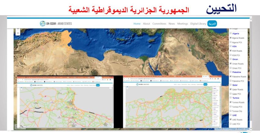
Spatial Data Infrastructure and Earth Observation Education and Training for North Africa

      Governance
      • The main responsible body is the National Council of Geographical
        Information (CNIG)
      • Established by an executive order in 1996, the CNIG is a advisory body
        responsible of studies, strategic orientations, coordination and proposition
        with respect of GI under the authority of the ministry of defense
      • Areas of competencies: geodesy, remote sensing, mapping in all
        applications fields
      • Members:
             • Representatives from various ministries: interior, finance, transportation,
               agriculture, energy…
             • Directors of the main geospatial data-producing agencies

16/03/2021                                                                                               3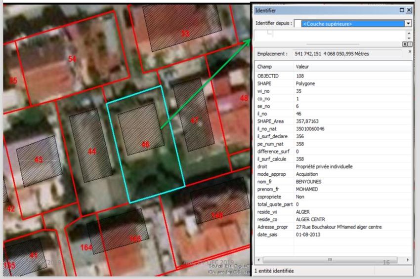
Spatial Data Infrastructure and Earth Observation Education and Training for North Africa

      Main National Agencies for GI/EO
      • National Institute of Mapping and Remote Sensing (INCT)
      • Algerian Space Agency (ASAL)
      • National Cadaster Agency
      • Research Center of Astronomy, Astrophysics and Geophysics (CRAAG)

16/03/2021                                                                                               4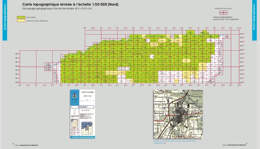
Spatial Data Infrastructure and Earth Observation Education and Training for North Africa

INCT
• Created in 1967, from 2009 has the status of an Industrial and Economic Public Company under
  the supervision of MoD.
• Main activities
    • Build and maintain geodetic, gravimetric and leveling networks over the whole territory
    • Cover the territory with aerial photography
    • Establish and update topographic maps at 1/50 000 and 1/200 000 scale and their derivatives
    • Acquire and conserve satellite imagery
    • Produce geographical databases
    • Undertake R&D works in geographical sciences area
    • Maintain the national archive of geographical information
• Customers: public administrations and public/private companies in different sectors such as
  defense, agriculture, land planning, telecommunications, energy, cadaster

16/03/2021                                                                                               5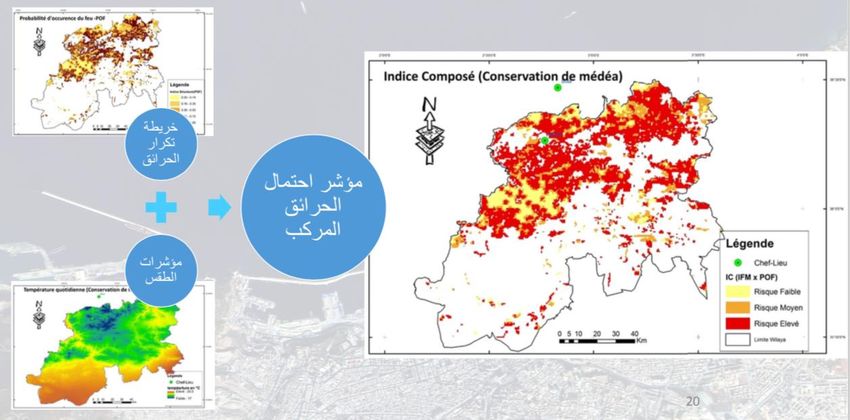
Spatial Data Infrastructure and Earth Observation Education and Training for North Africa

INCT: Core Infrastructure
• GPS
      • 06 permanent GNSS stations
      • First-order GPS network of 1180 points distant from
        25 to 50 km
• Gravimetric network
      • A fundamental network composed of 12 absolute
        points observed in 2011 (mean accuracy : 1.5 μgal)
      • Secondary network composed of 1985 points
        obtained by relative gravity measures in 2011 (mean
        accuracy : 0.02 mgal)
• Leveling network
      • Covers 40255 Kilometers (mean relative accuracy at
        centimeter order).

 [Source: INCT, Country Report: Algeria HIGH LEVEL FORUM ON
 GLOBAL GEOSPATIAL MANAGEMENT INFORMATION, Second
 Forum Doha, Qatar, 2013]

M. Kaddour, UORAN1                                                                                       6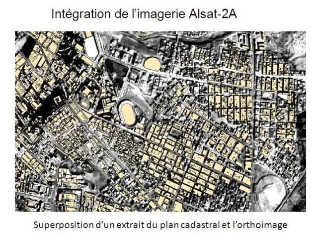
Spatial Data Infrastructure and Earth Observation Education and Training for North Africa

INCT: Aerial Photography
  • Proper capacities for aerial missions : 2
    Beechcraft KING AIR airplanes acquired in 1996
    and 2011
  • Very high resolution: 0.05 to 1.00m in RGB and
    near-infrared.
  • Scales: 1/4000, 1/20 000; 1/40 000, 1/50 000,
    1/60 000, 1/75 000

                                                                              Ain Defla RGB 10cm

M. Kaddour, UORAN1                                                                                       7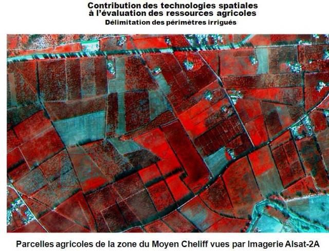
Spatial Data Infrastructure and Earth Observation Education and Training for North Africa

 INCT: Mapping Activities
  • A program started in 1980 to replace old 1/50 000 maps and produce 1/200 000 maps
  • Switching from Lambert conic projection to UTM
  • From 2007, updating topographic 1/50 000 maps using aerial photography
  • Using satellite images from different operators (ALSAT2, SPOT, LANDSAT, QuickBird, WorldView,
    etc.) to produce 1/200 000 maps
  • Themes:
      • City maps,
      • General maps at different scales
      • Road maps
      • Geological maps
      • Hydrological maps
  • Most products (maps, databases) are subject to restrictions on sale:
      • Access to data has to be motivated.

M. Kaddour, UORAN1                                                                                       8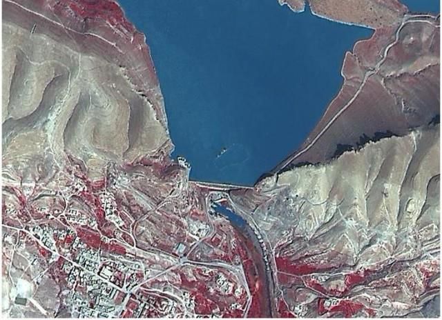
Spatial Data Infrastructure and Earth Observation Education and Training for North Africa
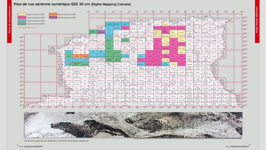
[Source: http://www.inct.mdn.dz]
M. Kaddour, UORAN1 9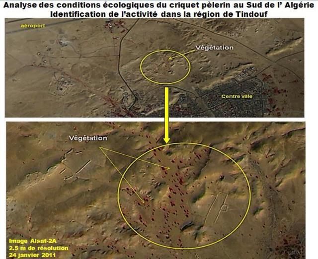
Spatial Data Infrastructure and Earth Observation Education and Training for North Africa

                                                                      [Source: http://www.inct.mdn.dz]
M. Kaddour, UORAN1                                                                                       10
Spatial Data Infrastructure and Earth Observation Education and Training for North Africa Geographical Databases • Geodetic database, names database, topographic database at 1/50 000, Raster databases at different scales. • Other databases are actually under development: cartographic database at 1/200 000, Roads database, altimetry database and the image database (satellite images, orthophotos, etc.). M. Kaddour, UORAN1 [Source: http://www.inct.mdn.dz] 11
Spatial Data Infrastructure and Earth Observation Education and Training for North Africa

                                                                     [Source: http://www.inct.mdn.dz]
M. Kaddour, UORAN1                                                                                      12
Spatial Data Infrastructure and Earth Observation Education and Training for North Africa
[Source: http://www.inct.mdn.dz]
M. Kaddour, UORAN1 13Spatial Data Infrastructure and Earth Observation Education and Training for North Africa
National Agency of Cadaster (Ministry of Finance)
• Nationwide geospatial database of land parcels (spatial features/ownership data
integration)
• Covered area: 228 290 265 km2
• Number of parcels: 5 008 613
• Number of owners: 3 957 462 persons [numbers of 2019, source: www.an-cadastre.dz]
• Data collection and validation process: aerial photography / GPS ground
reference -> verification and correction at local antennas involving land
registration agencies
• Standards: ISO 6709 (Algeria 18257) and ISO 19152 (Algeria 18275)
• From 20/01/2020, a web service to download official documents (https://www.an-
cadastre.dz/wathikacad/WathikaCad.php)
• Current users: land experts, notaries, government property agencies, to be extended to
agricultural agencies and forestry services
• Number of documents downloaded at 16/02/2020: 69 981
M. Kaddour, UORAN1 14Spatial Data Infrastructure and Earth Observation Education and Training for North Africa
[Source: National agency of
cadaster, Management of large-
scale geographic information,
seventh meeting of UN-GGIM
Arab state committee, Algiers
2020.}
M. Kaddour, UORAN1 15Spatial Data Infrastructure and Earth Observation Education and Training for North Africa
[Source: National agency of
cadaster, Management of large-
scale geographic information,
seventh meeting of UN-GGIM
Arab state committee, Algiers
2020.}
M. Kaddour, UORAN1 16Spatial Data Infrastructure and Earth Observation Education and Training for North Africa
Algerian Space Agency (ASAL)
• Public national organization created in 2002 under the authority of
the head of government, representatives from 15 ministries
• Design and implement the national policy of promotion and
development of space activities
• 4 operational entities:
• Centre des Techniques Spatiales (CTS)
• Centre des Applications Spatiales (CAS)
• Centre de Développement des Satellites (CDS)
• Centre d’exploitation des Systèmes de Télécommunications (CEST)
M. Kaddour, UORAN1 17Spatial Data Infrastructure and Earth Observation Education and Training for North Africa
EO Satellites operated by ASAL
• Alsat-1 (2002-2010): altitude 700km, resolution 32m, swath 300km, RG and near-
infrared, 2 cameras with 17km overlapping, image size: 600 × 560 Km
• Alsat-1B (2016): altitude 670km, resolution 24m spectral and 12m panchromatic,
RGB and near-infrared, swath 140km, 40 scenes per day
• Alsat-2A and Alsat-2B constellation (2010,2016): resolution 2.5m panchromatic
and 10m multispectral, swath 17.5 km, RGB and near-infrared, revisit time 3 days
Alsat-1B
Alsat-2
M. Kaddour, UORAN1 18Spatial Data Infrastructure and Earth Observation Education and Training for North Africa
[Source: https://asal.dz]
M. Kaddour, UORAN1 19Spatial Data Infrastructure and Earth Observation Education and Training for North Africa
Le barrage de l’Oued Ksab, vu par Alsat-2A
Flooding area
[Source: https://asal.dz]
M. Kaddour, UORAN1 20Spatial Data Infrastructure and Earth Observation Education and Training for North Africa
Main Application Areas of GIS and Satellite Imagery at CTS
• Natural resources
• Atlas of solar fields
Telecommu
• Management plan of fisheries and halieutic resources Disaster nications
management
• Geological maps 19%
16%
• Land occupation maps
• Sahara agriculture
• Hydrogeological prospecting
• Urban planning, infrastructure, equipment
• Development of housing programs
• Monitoring of precarious habitat Infrastructure and Natural
facilities ressources
• Management of touristic extension areas 33% 32%
• Natural risk mitigation and disaster management
• Monitoring and impact studies of flooding events
• Impact of wildfires
• Desertification monitoring
• Locust plagues
M. Kaddour, UORAN1 21Spatial Data Infrastructure and Earth Observation Education and Training for North Africa
Project Examples: Management and Planning of Fisheries
• Participants: ICNT, CTS,
CNRDPA, ministry of fisheries
• Objective: sustainable
exploitation of halieutic
resources
• 6 pilot areas: Algiers, Tizi-
ouzou, Tlemcen…
[Source: https://asal.dz]
M. Kaddour, UORAN1 22Spatial Data Infrastructure and Earth Observation Education and Training for North Africa
Project Examples: Solar Fields
• Objective: identifying
sites with high potential
of solar energy
production
• Climate and radiometric
data from the National
Office of Meteorology
[Source: https://asal.dz]
M. Kaddour, UORAN1 23Spatial Data Infrastructure and Earth Observation Education and Training for North Africa Project Examples: Risk Maps of Wildfire • Statistical Data from National Forest Agency [Source: https://asal.dz] M. Kaddour, UORAN1 24
Spatial Data Infrastructure and Earth Observation Education and Training for North Africa

 National SDI
      •   Not operational yet, preliminary tasks started around 2018-2019
      •   Project managed by the CNIG
      •   Main stakeholders: INCT, ASAL, Cadaster, OGEF (national order of land surveyors)
      •   Thematic layers:
            •   Layer 1 : Topography
            •   Layer 2 : Cadaster
            •   Layer 3 : Orthoimagery
            •   Layer 4: Urban areas
            •   Layer 5: Coasts
            •   Layer 6: Water resources
            •   Layer 7: Land use
      • Current activities are targeting the adoption of GI standards (ISO/TC 211, OGC)

M. Kaddour, UORAN1                                                                                       25
Spatial Data Infrastructure and Earth Observation Education and Training for North Africa
Standardization Activities
• Committee of geospatial data A survey was conducted on usage of standards
standardization: members from among stakeholders: 51 responses
IANOR (Institut Algérien de REPARTITION OF STAKEHOLDERS
Normalisation) and CNIG (from Services
Geospatial data 3%
march 2018) producers
Research
Institutes
18%
• From 2018 to 2019: adoption of 21%
35 ISO/TC 211 standards as
Algerian standards
Public
Administration
[Source: Fethi Doukha, CNIG, Algerian experience in the standardization 31% Higher Education
of geospatial information, seventh meeting of UN-GGIM Arab state Institutions
committee, Algiers 2020] 27%
M. Kaddour, UORAN1 26Spatial Data Infrastructure and Earth Observation Education and Training for North Africa
Key Barriers for Widespread Adoption of GI Standards
Lack of Knowledge Understanding issues
17% 5%
Most standards in English
5%
Limited accessibility Lack of technical capacities
12% 4%
Acquisistion Costs
4%
No response [Source: Fethi Doukha,
8%
CNIG, Algerian
Absence of general
framework experience in the
15% standardization of
geospatial information,
seventh meeting of UN-
Implementation costs
15% GGIM Arab state
Absence of regulation committee, Algiers
15% 2020]
M. Kaddour, UORAN1 27Spatial Data Infrastructure and Earth Observation Education and Training for North Africa
Activities of the UN-GGIM Arab States Committee
• 22 countries: Egypt, Algeria, Morocco, Tunisia, KSA, EAU…
• Annual meetings, first one took place in 2015
• 4 workgroups:
• Institutional Arrangements, Legal and Policy Issues, Awareness and Capacity Building
• Fundamental Data and Geo-Standards
• Geodetic Reference Frame
• Integration of Geospatial & Statistical Information
• Main ongoing tasks:
• Increase awareness about the importance of a strong legal framework around
geospatial data
• 2020-2023: define thematic areas and their relevance to sustainable development
• Implement the requirements of the ARABREF: unified Arab geodetic reference
• Implementation of a unified geoportal for Arab countries
• www.un-ggim-as.org/en
M. Kaddour, UORAN1 28Spatial Data Infrastructure and Earth Observation Education and Training for North Africa
Arab Geoportal (1)
Thematic layers
[Source: UN-GGIM Arab States Committee, Workgroup 2, Progress
Report, Oman, february 2018]
M. Kaddour, UORAN1 29Spatial Data Infrastructure and Earth Observation Education and Training for North Africa
Arab Geoportal (2)
[Source: UN-GGIM
Arab States
Committee,
Workgroup 2,
Main foundations
of geospatial data
platform , Oman,
february 2021.]
M. Kaddour, UORAN1 30Spatial Data Infrastructure and Earth Observation Education and Training for North Africa Arab Geoportal (3) • URL: http://geoportal.un-ggim-as.org/UNGGIM-AS-V4/ • Currently only 4 layers on 7 countries: background imagery, topography, roads, POI • Still experimental, some accessibility issues/bugs M. Kaddour, UORAN1 31
Spatial Data Infrastructure and Earth Observation Education and Training for North Africa

GI/EO in Academia
         Institution                                 Curriculum
         CTS                                         Engineer/Technician in Geomatics, Geodesy, remote
                                                     sensing, spatial Instrumentation
         University of Setif 1, Institute of         MSc in Geomatics for architecture and urban planning
         Architecture and Earth Sciences
         USTHB, Faculty of Earth Sciences and        MSc in Geomatics
         Land Management
         University of Constantine, Faculty of       BSc in Topography and Geomatics, MSc in Geomatics,
         Earth Sciences, Geography, and Land         MSc in Topography, Mapping and GIS
         Management
         University of Tlemcen, Faculty of Earth     BSc in Topography and Geomatics, BSc. Geomatics for
         Sciences and Geography                      Urban Planning and Environment
         University of Oran 2, Faculty of Earth      MSc in Geomatics
         Sciences and Geography

 M. Kaddour, UORAN1                                                                                        32
Spatial Data Infrastructure and Earth Observation Education and Training for North Africa
VET
• CTS offers regular training sessions for professionals in topics such as
geomatics, geodesy, topography, cadaster, remote sensing,
photogrammetry, mapping
• Public: construction companies, cadaster, order of land surveyors, law
enforcement, ministry of culture, water agencies, environmental agencies
• Some private institutes offers training sessions in Geomatics/GIS
• InfoCarte, LAKA Engineering Services (Algiers), Geospatial and Scientific
Solutions (Oran), National School for Hydraulics
M. Kaddour, UORAN1 33Spatial Data Infrastructure and Earth Observation Education and Training for North Africa
Research and Development on GI/EO
• 8 research centers and about 50 research laboratories affiliated to
universities or high institutes
• Thousands of research papers on Google Scholar: journals (elsevier,
springer, etc.), conferences
• 87 PhD thesis (defended/current) on GI/EO-related topics from 2010
(source: national thesis portal: www.pnst.cerist.dz)
M. Kaddour, UORAN1 34Spatial Data Infrastructure and Earth Observation Education and Training for North Africa Research Centers in GI/EO • Center for Space Techniques, Oran • Center of Research in Astronomy, Astrophysics and Geophysics, Algiers • Center for development of renewable energies, Ghardaïa • Center for development of renewable energies, Tipaza • Scientific and Technical Research Center of Arid Regions - Biskra • National Center of Applied Research in Earthquake Engineering(CGS), Algiers • Algerian Geological Survey Agency (ASGA), Algiers • Algerian National Institute of Research on Agronomy (INRAA) M. Kaddour, UORAN1 35
Spatial Data Infrastructure and Earth Observation Education and Training for North Africa

Laboratories in GI/EO (1/5)
• Laboratory L.I.S, University of Setif, Algeria
• Laboratoire Espace Géographique et Aménagement du Territoire, University of
  Mostaganem
• Laboratory water and environment, University of Tébessa
• Laboratory of Soils and Sustainable Development, University of Annaba
• Laboratory of Water Sciences-LRS-EAU, National Polytechnic School, Algiers
• Water and Environment Laboratory, University of Chlef
• Laboratory of Geo Resources, Environments and Natural Risks, University of Oran2
• Laboratory of Geographical Space and Territorial Planning, University of Oran 2
• Laboratory of Natural Hazards and Spatial Planning (LRNAT), University of Batna
• Laboratoire LIO, University of Oran 1
• Laboratoire LITIO, University of Oran 1
• Laboratoire de Traitement d’Images et Rayonnement (L.T.I.R.) – USTHB, Algiers
M. Kaddour, UORAN1                                                                                       36
Spatial Data Infrastructure and Earth Observation Education and Training for North Africa

Laboratories in GI/EO (2/5)
•   Laboratoire Géo-Environnement, University of Mascara
•   Laboratory of Geology and Environment (LGE), University of Constantine 1
•   Laboratory of Geophysics, USTHB
•   Laboratoire des Écosystèmes Marins et Littoraux (ECOSYSMarL), Ecole Nationale
    Supérieur des Sciences de la Mer et de l’Aménagement du Littoral, Algiers
•   Laboratory of Geodynamics and Natural Resources, University of Annaba
•   Laboratory of Underground Reservoirs of Gas, Oil and Aquifer, University of Ouargla
•   Laboratory for Biotoxicology, Pharmacognosy and Biological Valorization of Plants,
    University of Saida
•   Laboratory of Metallogeny and Magmatism, USTHB
•   Laboratory of Geology, University of Annaba
•   Laboratoire de la Promotion et valorisation des ressources sahariennes (VPRS), University
    of Ouargla

M. Kaddour, UORAN1                                                                                       37
Spatial Data Infrastructure and Earth Observation Education and Training for North Africa Laboratories in GI/EO (3/5) • Signal, Systems and Telecommunication Laboratory, University of Laghouat • Laboratory of Bio-toxicology, University of Saida • Laboratoire des Risques Naturels et Aménagement de Territoire (LRNAT), University of Batna 2 • Laboratory of Geomatics, Ecology and Environment, University of Mascara • Geomatic & sustainable Development Laboratory, University of Tiaret • Mines Laboratory, University of Tebessa • Laboratory of Crop Production and Sustainable Valorization of Natural Ressource, University of Khemis-Miliana • Laboratory of Geophysic (LGEOPH),USTHB, Algiers, Algeria • Biodiversity & Conservation of water and Soil Laboratory, University of Mostaganem M. Kaddour, UORAN1 38
Spatial Data Infrastructure and Earth Observation Education and Training for North Africa

Laboratories in GI/EO (4/5)
  • Water and Environment Laboratory, University of Saida
  • Plant Ecology and Environmental Laboratory – USTHB;
  • Laboratory of Geodynamics and Geology of the Engineer and Planetology,
    Algiers
  • Laboratory of Ecosystem Diversity and Dynamics of Agricultural Production
    Systems in Arid Zones, University of Biskra
  • Laboratoire Ecodéveloppement des espaces, University of Sidi Bel Abbes
  • Laboratoire de Conservation des Zones Humides, University of Guelma
  • Signals and Systems Laboratory, University of Boumerdes1
  • Laboratory of Mineral and Energetical Resources University of Boumerdes
  • Laboratory of Protection and Development of Coastal Marine Resources
    and Molecular Systematics, University of Mostaganem
M. Kaddour, UORAN1                                                                                       39
Spatial Data Infrastructure and Earth Observation Education and Training for North Africa Laboratories in GI/EO (5/5) • Laboratory of Biomathematics, Biophysics, Biochemistry, and Scientometry, University of Bejaia • Laboratoire de Géodynamique, Géologie de l’Ingénieur et Planétologie, USTHB • Laboratory of Development and Valorisation of Phyto-Genetics Resources, University of Constantine • Laboratoire de recherche : Biodiversité Végétale: conservation et valorisation, Université of Sidi Bel Abbes • Laboratory of Hydraulic, National Higher Institution for Agriculture (ENSAA), Algiers • LESRMHAO Laboratory, Tebessa University, 12002 Tebessa • Laboratory Biodiversity and Conservation of Water and the Soils, University of Mostaganem • Laboratory of Geomorphology and Geo-risks, USTHB • Laboratoire des Matériaux et Systèmes Réactifs (LMSR), University of Sidi Bel Abbes • Laboratoire des Sciences et Techniques de l’Environnement et de la Valorisation, Mostaganem M. Kaddour, UORAN1 40
Spatial Data Infrastructure and Earth Observation Education and Training for North Africa

Conclusion: Experts Recommandations
From the Proceeding the National Conference « Remote Sensing and Geomatics:
New Horizons for City Management», held in October 2019 at the University of
M’sila (Participants: CNIG, INCT, ASAL and various universities)

1. Deploy simple ways to access GI data for pedagogical and scientific purposes
2. Enable the visibility and vulgarization of available GI data
3. Strengthen cooperation and partnerships between institutions for exchange of
   experience and scientific expertise
4. Embody the various collaboration agreements with pilot project having shared
   interests
5. Put in place legal and technical mechanisms to establish an unified GI
   datawarehouse
M. Kaddour, UORAN1                                                                                       41
Spatial Data Infrastructure and Earth Observation Education and Training for North Africa

References
 • INCT, Country Report: Algeria HIGH LEVEL FORUM ON GLOBAL GEOSPATIAL MANAGEMENT INFORMATION, Second Forum Doha, Qatar, 2013
 • Fethi Doukha, CNIG, Algerian experience in the standardization of geospatial information, seventh meeting of UN-GGIM Arab state
   committee, Algiers 2020. [Arabic]
 • Proceedings of the scientific days celebrating the 20th anniversary of the foundation of CTS, Arzew 2007. [French]
 • Proceedings of the national conference « Remote Sensing and Geomatics: new horizons fot city management», University of M’sila, October
   2019 [Arabic, French]
 • National agency of cadaster, Management of large-scale geographic information, seventh meeting of UN-GGIM Arab state committee, Algiers
   2020. [Arabic]
 • BAAZIZ Brahim, SEDDIKI Mohamed Akram, Contribution du Géomètre Expert dans le projet d’Infrastructure Nationale des Données
   Géographiques INDG, 7èmes Universités de la FGF, Rabat, 2018 [French]
 • UN-GGIM Arab States Committee, Workgroup 2, Progress Report, Oman, february 2018.
 • UN-GGIM Arab States Committee, Workgroup 2, Main foundations of geospatial data platform , Oman, february 2021.
 • ASAL, Usage of national space systems for developing and monitoring border areas, CIC – 13 - 14 October 2018 [French]
 • http://www.inct.mdn.dz
 • https://asal.dz
 • https://www.an-cadastre.dz/
 • https://www.un-ggim-as.org/en
 • https://www.pnst.cerist.dz
 • https://scholar.google.com
 • https://www.researchgate.net
 M. Kaddour, UORAN1                                                                                                                  42
You can also read