Cycle Network Plan Draft Greater Dublin Area - National Transport Authority
←
→
Page content transcription
If your browser does not render page correctly, please read the page content below
Draft
Greater Dublin Area

Cycle
Network
Plan
Draft Greater Dublin Area Cycle Network Plan
                                                                                                                                  TABLE OF CONTENTS

PART 1: WRITTEN STATEMENT                                                                                                                                       3.8.   Dublin South East Sector ................................................................................................ 44
INTRODUCTION                                                                                                                                                           3.8.1    Dublin South East - Proposed Cycle Route Network........................................................... 44
                                                                                                                                                                       3.8.2    Dublin South East - Proposals for Cycle Route Network Additions and Improvements ...... 44
CHAPTER 1        EXISTING CYCLE ROUTE NETWORK ....................................................... 1
                                                                                                                                                                       3.8.3    Dublin South East - Existing Quality of Service ................................................................... 45
         1.1.   Quality of Service Assessments ........................................................................................1
                                                                                                                                                        CHAPTER 4               GDA HINTERLAND CYCLE NETWORK ................................................... 46
         1.2.   Existing Cycling Facilities in the Dublin City Council Area..................................................1
                                                                                                                                                                4.1    Fingal County Cycle Route Network................................................................................ 46
         1.3.   Existing Cycling Facilities in South Dublin County Area .....................................................3
                                                                                                                                                                       4.1.1    South Fingal Sector.............................................................................................................. 46
         1.4.   Existing Cycling Facilities in Dun Laoghaire-Rathdown Area .............................................5                                              4.1.2    Central Fingal Sector ........................................................................................................... 47
         1.5.   Existing Cycling Facilities in Fingal County Area................................................................ 6                                    4.1.3    North Fingal Sector .............................................................................................................. 48
         1.6.   Existing Cycling Facilities in County Meath........................................................................7                                   4.1.4    Rural Cycle Routes in Fingal ............................................................................................... 48
         1.7.   Existing Cycling Facilities in County Kildare.......................................................................9                           4.2    County Meath Cycle Route Network ............................................................................... 50
         1.8.   Existing Cycling Facilities in Wicklow............................................................................... 10                               4.2.1    South Meath Sector Towns Cycle Networks ....................................................................... 50
CHAPTER 2                 FUTURE CYCLE NETWORK PLANNING ................................................. 11                                                           4.2.2    Central Meath Sector Town Cycle Networks ....................................................................... 50
         2.1.   Strategic Urban and Transport Planning .......................................................................... 11                                   4.2.3    East Meath Sector Town Cycle Networks ........................................................................... 50
         2.2.   Cycling Trip Demand Analysis ......................................................................................... 13                              4.2.4    Rural Cycle Routes in Meath ............................................................................................... 51
         2.3.   Strategic Cycle Route Network Proposals ....................................................................... 16                              4.3    County Kildare Cycle Route Network .............................................................................. 53
         2.4.   Strategic Environmental Assessment .............................................................................. 22                                   4.3.1    North Kildare Sector Town Cycle Networks......................................................................... 53
                                                                                                                                                                       4.3.2    Mid-Kildare Sector Town Cycle Networks ........................................................................... 53
CHAPTER 3                 DUBLIN METROPLITAN AREA CYCLE NETWORK ................................ 23                                                                    4.3.3    South Kildare Sector Town Cycle Networks ........................................................................ 53
         3.1.   Dublin City Centre Cycle Network.................................................................................... 23                                4.3.4    Rural Cycle Routes in Kildare .............................................................................................. 53
                3.1.1     Gateways on the Main Radial Access Corridors into City Centre........................................ 23                              4.4    County Wicklow Cycle Route Network ............................................................................ 55
                3.1.2     Dublin City Centre - Context for the Cycle Route Network .................................................. 28
                                                                                                                                                                       4.4.1    North Wicklow Sector Town Cycle Networks....................................................................... 55
                3.1.3     Dublin City Centre - Proposed Cycle Route Network .......................................................... 30
                                                                                                                                                                       4.4.2    South Wicklow Sector Town Cycle Networks ...................................................................... 56
         3.2.   Dublin North East Sector ................................................................................................. 31                          4.4.3    West Wicklow Sector Town Cycle Networks ....................................................................... 56
                3.2.1     Dublin North East - Proposed Cycle Route Network ........................................................... 31                              4.4.4    Rural Cycle Routes in Wicklow ............................................................................................ 56
                3.2.2     Dublin North East - Cycle Route Network Additions ............................................................ 31
                                                                                                                                                        CHAPTER 5               SUMMARY AND CONCLUSIONS ............................................................. 59
                3.2.3     Dublin North East - Existing Quality of Service.................................................................... 32
         3.3.   Dublin North Central Sector............................................................................................. 33             PART 2                  EXISTING CYCLING FACILITIES MAPS ................................................. 61
                3.3.1     Dublin North Central - Proposed Cycle Route Network ....................................................... 33                PART 3                  CYCLING DEMAND MAPS ...................................................................... 62
                3.3.2     Dublin North Central - Cycle Route Network Additions ....................................................... 33               PART 4                  PROPOSED CYCLE NETWORKS MAPS ................................................ 63
                3.3.3     Dublin North Central - Existing Quality of Service ............................................................... 34
                                                                                                                                                                Part 4a:        Overall GDA Cycle Network Maps
         3.4.   Dublin North West Sector ................................................................................................ 35
                                                                                                                                                                Part 4b:        Proposed Cycle Network Dublin Area
                3.4.1     Dublin North West - Proposed Cycle Route Network .......................................................... 35
                3.4.2     Dublin North West - Cycle Route Network Additions ........................................................... 35
                                                                                                                                                                Part 4c:        Proposed Cycle Network in Towns
                3.4.3     Dublin North West - Existing Quality of Service................................................................... 35                 Part 4d:        Rural Cycle Routes
         3.5.   Dublin West Sector.......................................................................................................... 36
                3.5.1     Dublin West - Proposed Cycle Route Network .................................................................... 36
                3.5.2     Dublin West - Proposals for Cycle Route Network Additions .............................................. 36
                3.5.3     Dublin West - Existing Quality of Service............................................................................. 37
         3.6.   Dublin South West Sector................................................................................................ 38
                3.6.1     Dublin South West - Proposed Cycle Route Network.......................................................... 38
                3.6.2     Dublin South West - Proposals for Cycle Route Network Additions and Improvements .....39
                3.6.3     Dublin South West Sector - Existing Quality of Service....................................................... 41
         3.7.   Dublin South Central Sector ............................................................................................ 42
                3.7.1     Dublin South Central - Proposed Cycle Route Network ...................................................... 42
                3.7.2     Dublin South Central - Cycle Route Network Additions ....................................................... 42
                3.7.3     Dublin South Central Sector - Existing Quality of Service ................................................... 43

  12.159.10                                                                                                                                       August 2013
INTRODUCTION Background
The National Cycle Manual (NCM) defines a cycle network as:
The National Transport Authority (NTA) commissioned AECOM Roughan & O’Donovan (AECOM-ROD) ‘a collection of connected routes. Routes are a set of connected links and junctions that follow
to prepare a Cycle Network Plan, comprising the Urban Network, Inter-Urban Network and Green Route logical corridors between zones or urban centres. The purpose of the cycle network is to
Network, for each of the seven Local Authority areas comprising the Greater Dublin Area (GDA), being: connect the main zones of origin and destination within an urban area and should provide
Dublin City Council (DCC) effective through-movement for cyclists. A well-planned cycle network will carry the vast majority
of cycle journeys.’
South Dublin County Council (SDCC)
Dun Laoghaire Rathdown County Council (DLRCC) Urban Cycle Networks are generally presented as a hierarchy of corridors that provide differing levels of
Fingal County Council (FCC) importance for cyclists and they are:
Meath County Council (MCC) Primary Network: Main cycle arteries that cross the urban area, and carry most cycle traffic;
Kildare County Council (KCC) Secondary Network: Links between the principal cycle routes and local zones; and
Wicklow County Council (WCC) Feeder:, Connections from zones to the network levels above and/or cycle routes within local
zones.
The Brief for the project requires the Cycle Network Plan to identify and determine in a consistent, clear
and logical manner the following cycle networks within the GDA: These facilities provide the backbone of cycle infrastructure in the GDA. This report also deals with
National and Inter-Urban Cycle Routes which have not been addressed in previous studies.
The Urban Cycle Network at the Primary, Secondary and Feeder level;
The Inter-Urban Cycle Network linking the relevant sections of the Urban Network and including The National Cycle Manual outlines a seven step method of designing a Cycle Network which must be
the elements of the National Cycle Network within the GDA. It shall also include linkages to key followed to ensure that the investment in infrastructure is justified. These steps are listed below:
transport locations outside of urban areas such as airports and ports; and Step 1: Inventory of Existing Cycling Regime;
The Green Route Network being cycle routes developed predominately for tourist, recreational Step 2: Understanding Trip Demand and the Potential for Cycling Trips;
and leisure purposes.
Step 3: Trip Assignment to the Network;
Unlike area-based plans prepared previously by Local Authorities, this Cycle Network Plan is to be Step 4: Trip Forecast;
consistent across county boundaries such that there is continuity of route networks across these Step 5: Urban and Transport Planning;
administrative boundaries.
Step 6: Prioritising Improvements; and
Context for this Study Step 7: Programme, Consultation, Budgets.
The Irish Government, the NTA and various State Agencies are committed to ensuring that cycling as a
transport mode is supported, enhanced and exploited, in order to achieve strategic objectives and reach This project comprises Steps 1 to 5 for the GDA area, with Steps 6 and 7 to be addressed as part of a
national goals. Current policy is set out in various documents produced by the Department of separate investment funding process.
Transport, Tourism & Sport and its Agencies. However, the National Cycle Policy Framework (NCPF) is
the key document that sets out 19 specific objectives, and details the 109 individual but integrated Study Methodology
actions, aimed at ensuring that a cycling culture is developed in Ireland to the extent that, by 2020, 10% The development of this Cycle Network Plan has followed a series of logical steps, which are outlined
of all journeys will be by bike. This document proposes a comprehensive package of on the graphic below.
planning/infrastructure and communication/education measures, and emphasises the need for
stakeholder participation and adequate funding of the required initiatives. The NCPF requires that The identified ‘needs’ of cyclists (outlined in the NCM) and key principles of functionality, homogeneity,
cycle-friendly planning principles be incorporated in all national, regional, local and sub-local plans. legibility, forgivingness and self-awareness have been taken into account by the Project Team, in
These ambitious targets can only be achieved if a much higher proportion of trips by bicycle is preparing this Cycle Network.
undertaken in urban areas, in particular within the GDA, where the use of bicycle for many types of trips
is already much more common.
Data Collection & Management
In order to ensure that national resources are applied in an efficient manner that will help in reaching Information on existing and proposed cycle facilities was provided by all the Local Authorities within the
these ambitious targets, the NTA and the Local Authorities within the GDA need to know what bicycle GDA, through their representative who sat on the Joint Project Team for this study. This information
facilities are currently available, where they are missing sections, what is their condition and what was provided in various formats and has been converted to GIS-based mapping in a common format
improvements are likely to be required. In addition, a strategic cycle network map of the GDA needs to which can be updated into the future as the cycle network changes and grows. All mapping has been
be prepared which will help the NTA in allocating funding towards the implementation of strategically undertaken using a GIS process which is INSPIRE-compliant, thus this mapping will be the basis for
important schemes. Information outlined in this report will allow cycle infrastructure projects to be many future NTA applications far beyond the scope of this project.
prioritised in terms of the importance to the strategic network and the likely cycle demand for such a
scheme.
12.159.10 August 2013 Page i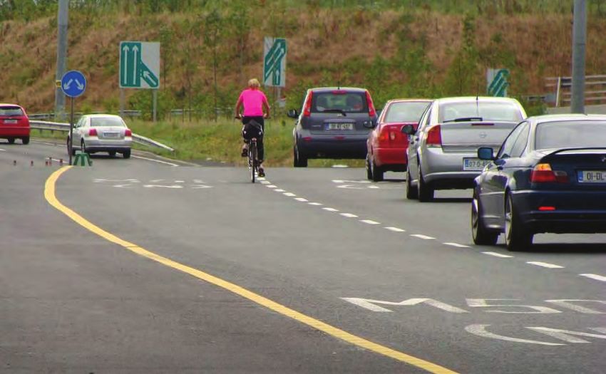
In order to confirm data and to undertake Quality of Service Assessments, site visits were undertaken
throughout the existing cycle network by the Project Team, although it is acknowledged that not every
facility was visited, due to the size of the study area.

                               Cycle Network Plan - Study Methodology

Consultation with the Local Authorities
The Project Team met with representatives of each of the seven Local Authorities on a number of
occasions during the lifetime of the project. The Local Authorities were the primary stakeholders for the
project. This group was consulted on an ongoing basis throughout the project in order to provide
information, confirm proposals and contribute to the development of the future Cycle Network Plan.

(Note on Source of Images: Some of the photographs contained in this report were obtained from
Google Streetview but were cropped to best suit the presentation of the image. The Google trademark
does not therefore appear on all such images, and the authors hereby acknowledge the source).

12.159.10                                                                                               August 2013   Page ii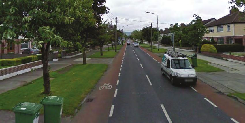
Greater Dublin Area   Part 1:
Cycle Network Plan
                      Written
                      Report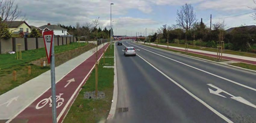
CHAPTER 1 EXISTING CYCLE ROUTE NETWORK There are several recent schemes in the city area that have been very well received by cyclists such as
the Grand Canal Cycle Route from Guild Street to Portobello, which has delivered a significant increase
in cyclists along the canal since its opening in 2011. A summary of the main types of provision for
In this chapter a summary is presented of the existing cycle route network within each Local Authority
cyclists in the City Council area is provided below.
area. This chapter should be read in conjunction with the maps E1 to E25 in Part 6 of this Volume 1.
The cycle route network for each Local Authority is summarised in the following sections.
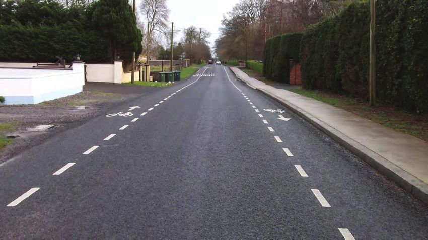
On Street Cycle Lanes in Dublin City Council Area
The predominant provision for cycling in the City Council area is by means of either on street cycle
1.1. Quality of Service Assessments lanes (both advisory and mandatory) or bus lanes. These facilities are generally of a low Quality of
Service in the city area mainly due to the lack of width for cyclists and the discomfort caused by large
The National Cycle Manual describes the five needs of a cyclist. volumes of vehicular traffic sharing the road space. Typically the cycle lanes achieve a QoS score of C
(i) Road Safety or D. Recent improvements in the pavement quality in the city centre have lifted the Quality of Service
(ii) Coherence from D to C on several of these routes.
(iii) Directness There has been difficulty in providing for cycle lanes in the city centre, where there is considerable
(iv) Attractiveness competition for street space and provisions for the bus and on street parking are often prioritised. The
(v) Comfort recent application of a 30 km/h speed limit in the core of the city centre shopping districts has
contributed to improved conditions for use of these streets by cyclists and traffic. There remains,
Quality of Service (QoS) is a measurement of the degree to which these needs of the cyclist are met. In however, an extensive network of streets between the core and the canal cordon where cycling facilities
order to attract risk-averse cyclists, Quality of Service should increase as cycle routes approach main are limited to a few radial routes.
destinations.
The National Cycle Manual provides guidance on the criteria that input into the QoS assessment. This
study involved one of the first major applications of the QoS evaluation process since the Manual was
published. The methodology was adapted slightly with the agreement of the NTA so as to enable
practical application on a large scale basis, with the following criteria utilised:
(i) Pavement Condition by visual assessment;
(ii) Width: ranging from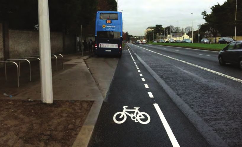
Bus lane on Pearse Street
Greenways in Dublin City Council Area
A number of high quality greenways have been provided in the city area including:
Sutton to Sandycove greenway along the East Coast at Raheny / Dollymount
Grand Canal greenway from Goldenbridge to the city boundary;
East Coast greenway from Clontarf to Sutton (with a 2km gap at Dollymount);
River Liffey greenway from the Memorial Gardens to Chapelizod; and
River Tolka greenway from Finglas Road to Ratoath Road.
Greenways generally score highly for Quality of Service due to segregation from traffic and limited
conflicts. For some of the older greenways the width may be narrower than desirable in the context of
shared or adjoining pedestrian use and the pavement condition may be poor in places due to wear and
tear over time. Typically the existing greenways achieve a QoS score in the range of B to A+.
The Grand Canal Greenway between Inchicore and Park West is a very high quality route for cycling
with excellent pavement quality, signage and lighting. However, the quality of the route is greatly
diminished by the presence of ‘barrier gates’ along the route, which causes unnecessary delay for
regular cyclists to negotiate, and great difficulty to those cycling with child seats, panniers and cargo
bikes who cannot effectively avail of the route. The QoS for this route therefore drops from A+ to as low
as C on the section at Bluebell with frequent barriers. Similar barriers in the form of kissing gates exist
on the recently opened River Tolka Greenway, although at less frequent intervals. Such barriers are a
pervasive problem across the Dublin City area (and in the adjoining South Dublin County area) and are
not compatible with the need to make best use of off-road cycle routes through green spaces and public
parks to deliver a high Quality of Service for cyclists in lieu of the road network where the scope for
good quality cycle routes is constrained. There may be a perceived requirement to restrict access to
the greenways for vehicles and animals, but alternative solutions to kissing gates should be provided
which do not force cyclists to dismount and make multiple manoeuvres to pass through the restriction.
Among the important issues to be considered in the planning and design of greenways are security of
users, hours of operation, frequency of access points, lighting and CCTV, especially if the greenways
function as cycle routes to school in winter time. Greenways must be easy to access from the various
zones in the network if they are to be successful, and prior agreement with Parks Departments, the
Gardaí and local residents are key to this.
12.159.10 August 2013 Page 21.3. Existing Cycling Facilities in South Dublin County Area
The administrative Area of South Dublin County Council has a population of 265,205 (2011 Census)
and is predominately urban in nature with the third largest population in the state, after Dun Laoghaire-
Rathdown and Dublin City. The county has a rural character along the south-east boundary, at the
edge of the Dublin and Wicklow Mountains and along the western boundary with Kildare. An extensive
network of cycling facilities has been provided over the last 15 years as part of infrastructural works.
However, cycle usage remains relatively low at approximately 3% (cycle to work and education, 2011
Census), particularly in the context of the relatively high density of the county. Of particular note is the
low level of usage for trips to Education, which is on a similar level to Fingal which has a much lower
population density.
Many of the facilities within the county have been provided as part of infrastructure schemes within the
county, including roads projects and Quality Bus Corridors (QBCs). This has given the county a
significant length of cycle lane and cycle track provision ranging in QoS from D to B. Some of the better Existing Cycle Tracks on R114 Firhouse Road
quality cycle tracks are in newly developing areas and have a very low level of usage. In older parts of
the urban area adjoining the eastern boundary with Dublin City, there are cycle lanes and tracks that Retrofitted Cycle Lanes in South Dublin
were retro-fitted onto existing roads, some of which are of poor quality with a QoS score of D, but the
Many cycle lanes have been retrofitted to the existing road network in many parts of the county. These
majority are moderately good and achieve a QoS score of C.
facilities are generally on-road cycle lanes or have been provided in place of the existing verge area.
Cycling Facilities on New Road Projects in South Dublin Often the residual traffic lane is too narrow and as a result the advisory cycle lane is encroached upon
by traffic which leads to a low QoS score of C or D. Cycle tracks in the verge would provide a higher
Many of the cycle facilities in the southern and western parts of the South Dublin area were provided as Quality of Service for cyclists.
part of new road schemes and generally consist of one-way segregated cycle tracks on both sides of
the new road. Examples can be seen along the Outer Ring Road and Firhouse Road below. Such
routes have a QoS score of B or C due to typical widths of less than 1.8m, which makes overtaking
difficult, and, more importantly, loss of priority at side road junctions in some cases.
Of interest is that some of these cycle tracks are provided in lieu of verge space which leads to a hard
and harsh landscape. However, where the verge is retained, as on the Firhouse Road, and the cycle
lane is behind the verge a much more pleasant environment is created.
Existing Cycle Lanes on Wainsfort Road, Templeogue
Green Routes in South Dublin
There are some Green Routes through public park lands or along the Grand Canal and the River
Dodder in the South Dublin area. A good example is indicated in the photograph below, which is the
new facility along the Grand Canal between Park West and Adamstown. However, a common problem
within the county is the difficulty in accessing these facilities due to the use of severely restrictive gates
at the entries. It is clear that these have been provided to secure the facilities from vehicles, animals,
Existing Cycle Tracks on R136 Outer Ring Road / Cheeverstown Road etc. However, they lead to considerable difficulty for cyclists and reduce the attractiveness and utility of
the route in several cases, as indicated through feedback to the authors of this report.
12.159.10 August 2013 Page 3Grand Canal Greenway with restrictive barriers
If these barriers were removed and replaced with simple bollards at 1.5m centres, as is common
practice in other countries, it would open up a potentially extensive off-road, high-quality cycle route
network through the large number of public parks and open spaces across the South Dublin County
area.
Cycle Crossings at the M50 Motorway in South Dublin
The M50 motorway severs much of South Dublin in two and forms a barrier to the movement of cyclists
in the county. While all M50 interchanges have dedicated pedestrian and cycle facilities, several of
these crossings are difficult for cyclists to find and are of a relatively poor quality and, as a result,
require significant upgrade. These upgrades need to include a clearly signposted route to the M50
crossing, and continuous and legible cycle facilities that are attractive for existing and new cyclists to
use. There are upgrade projects proposed by the NRA for the crossings at Junction 7 (N4), Junction 9
(N7) and Junction 11 (N81).
Cyclist at an M50 Crossing in South Dublin
12.159.10 August 2013 Page 41.4. Existing Cycling Facilities in Dun Laoghaire-Rathdown Area Greenways in Dun Laoghaire-Rathdown
The administrative Area of Dun Laoghaire Rathdown County Council has a population of 206,261 (2011 Several parks within this county have cycle lanes provided through them, some running to quite
Census) and is primarily urban in nature with little rural hinterland (apart from near the southern significant lengths. These facilities provide local links and also form part of the radial commuter route
boundary with Wicklow County Council). The area has an extensive network of cycle facilities provided network. Some good examples can be seen in Kilbogget Park between Cabinteely and Ballybrack, in
over the last 20 years and, from the 2011 Census, it has the second highest cycle modal share in the Blackrock Park and along the River Dodder at Milltown. There is also a new greenway along the River
GDA for travelling to education and work, at 5.1%. In addition, the county has recorded some of the Slang between Dundrum and Marlay Park. Unlike other local authority areas, there are fewer barriers
higher levels of growth of this mode in the State. at access points to these greenways and no kissing gates, thus making these routes cycle-friendly.
Facilities are generally available on many of the radial routes leading to Dublin City Centre from this
county, with most provided as part of Quality Bus Corridor (QBC) projects. While in general the Quality
of Service of many of these facilities is low at C, there are ongoing upgrade works on the N11 Stillorgan
Road aimed at improving its Quality of Service.
Other facilities have been provided by the council along new roads or retrofitted to existing roads that
were being upgraded at the time. The QoS of these facilities varies from a low of D on older roads such
as Leopardstown Road East to a high of B on newer roads such as Murphystown Way.
River Slang Greenway, Dundrum
Cycle Crossings at the M50 Motorway in Dun Laoghaire-Rathdown
There are severance issues for cyclists at the M50 motorway Junction 13 West at Ballinteer, Junction
13 East at Sandyford and at Junction 15 Carrickmines. Upgrade works are required at these crossings.
Recently upgraded Cycle Lane at Bus Stop on N11
Existing Cycle Lanes within Bus Lanes on Rock Road
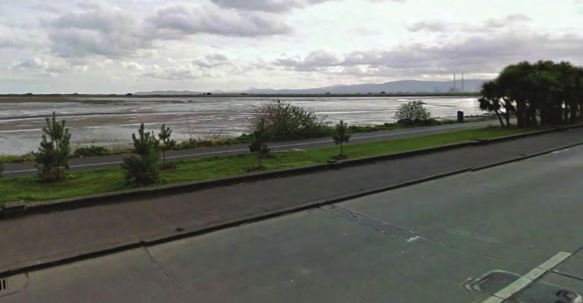
12.159.10 August 2013 Page 51.5. Existing Cycling Facilities in Fingal County Area
The administrative Area of Fingal County Council has a population of 273,051 (2011 Census) and has a
mixture of densely populated urban centres in the south and sparsely populated rural areas in the north.
The population in Fingal has steadily increased over the past 15 years and between Census 2006 and
Census 2011, a 13.8% population increase was recorded in the county, while the comparable figure
nationally was 8.1%. This was the second highest population increase in the country.
The major towns and urban areas in Fingal are:
Blanchardstown / Castleknock;
Swords / Malahide / Portmarnock;
Howth / Sutton / Baldoyle / Clongriffin;
Balbriggan / Skerries / Rush / Lusk; and
Donabate / Portrane.
Within these urban areas there are limited extents of cycling facilities, mostly consisting of cycle tracks Cycle Lanes on River Valley Road in Swords
provided along with new roads or bus lanes. Generally there has been limited retro-fit of cycle lanes on
older roads in the Fingal area. The following examples illustrate the range of existing conditions for In some of the areas that grew significantly in the past 20 years, such as Blanchardstown, the existing
cyclists. cycle track network is quite extensive as a result of provisions alongside new roads. However, in most
cases these cycling facilities score quite poorly for Quality of Service due to loss of priority at junctions.
It would be a straightforward matter to upgrade these cycle tracks with junction improvements, which
would lift the Quality of Service significantly for relatively small cost.
Castleknock Road with no cycling facilities
Cycle Tracks on Ongar Distributor Road in Blanchardstown
Rural Cycle Links between Towns in Fingal
There are no cycling facilities outside the towns in the rural areas of Fingal, apart from a short section
along the coast between Portmarnock and Malahide. There are several clusters of towns that could
benefit from linking cycle routes across the short separating rural areas, such as Balbriggan and
Skerries, Rush and Lusk, Portrane and Donabate to Swords, and Malahide to Swords.
Cycle Lane on R132 Swords Road between Swords and Dublin Airport
(QoS score of D due to lack of segregation from high-speed traffic and narrowness)
12.159.10 August 2013 Page 61.6. Existing Cycling Facilities in County Meath Enfield
The population of Meath County, according to Census 2011, is 184,135. This study focused on Cycling facilities are provided on both sides of the R148 Dublin Road. These consist of advisory cycle
establishing an inventory of the cycling facilities within the larger towns of Meath County, which provide lanes along the majority of the route but there are also some small sections of cycle tracks immediately
approximately 45% of Meath’s population. adjacent to the road. The cycle lanes provide connectivity along the entire length of Enfield Main
Street.
Table 1.6 Urban Populations in Meath
Ashbourne
TOWN POPULATION* Within Ashbourne, facilities are provided on sections of the R135, the Ballybin Road, Cluian Ri, Bourne
Navan 28,600
Avenue, Hunters Lane and in the Churchfields and White Ash Park residential estates. The majority of
these facilities consist of cycle tracks immediately adjacent to roads but there are also some cycle
Ashbourne 11,400 tracks separated from the road by grass verges and cycle lanes. There is also a trail that connects the
Laytown - Bettystown 10,900 R135 Dublin Road and Deerpark via Broad Meadow Water. The cycle track provided along Bourne
Ratoath 9,000 Avenue provides connectivity with the local GAA Club and Gaelscoil.
Trim 8,300
Dunboyne 7,000
Kells 5,900
Dunshaughlin 3,900
Stamullen 3,100
Enfield 2,900
Clonee 600
*Source: Census 2011 rounded to the nearest 100
Navan
Within Navan, dedicated facilities for cyclists are provided on the N51, between the Kells Road and the
Slane Road, on the N51 Navan Inner Relief Road and on the local road between the R162 and the Existing Cycle Facilities in Ashbourne
Ratholdren Road. These facilities along new roads include cycle tracks that are separated from and
immediately adjacent to the road. The older roads do not have cycling facilities and this has resulted in Ratoath
a fragmented cycle network in Navan. There are cycle tracks provided along a short section of the R125 and in the Milltree Park and
Steeplechase residential estates. In Milltree Park the cycle track provides connectivity to St. Paul’s
National School, Ratoath College and the local Scout Den.
Existing Cycle Facilities along the N51 in Navan
Kells Existing Cycling Facilities in Ratoath
There are no existing cycle facilities in Kells, which is 15km distant from Navan.
Trim
Within Trim, dedicated facilities for cyclists are provided on the R154, the R160, the R161 and in the
Knightsbrook complex off the R154. These facilities include cycle tracks that are separated from and
immediately adjacent to the road, and cycle lanes.
12.159.10 August 2013 Page 7Dunshaughlin
There is a limited provision of cycle facilities in Dunshaughlin. Cycle facilities are confined primarily to
the bus lane on the R147 Navan Road. A short section of cycle track is also provided on the R147 at
Main Street.
Dunboyne & Clonee
There are no cycling facilities in Dunboyne and no suitable route for the short connection to nearby
Clonee and onward to Dublin.
In Clonee there is a cycle track provided along a short section of the R149 Clonee Road. Cycle lanes
are also provided on both sides of the R156 Main Street through Clonee Village. The village is not
connected by a cycle route to the adjacent Littlepace and Hansfield areas of Blanchardstown and the
rest of the Dublin metroplitan area network, despite the very short separation distance.
Existing advisory cycle lanes at Stamullen
Rural Cycle Links between Towns in County Meath
There are no cycling facilities outside the towns in the rural areas of Meath, even though some are
closely clustered such as Ashbourne, Ratoath and Dunshaughlin.
Existing Cyclists Facilities along the R149 and R156 in Clonee
Laytown and Bettystown
There are no existing cycle facilities in Laytown or Bettystown and no route to nearby Drogheda, which
is the main regional centre.
Stamullen
Stamullen and Gormanston are well connected with the provision of advisory cycle lanes on both sides
of the road between Stamullen Village and Gormanston College.
12.159.10 August 2013 Page 81.7. Existing Cycling Facilities in County Kildare Cycle facilities in Leixlip are confined primarily to Station Road and sections of Green Lane (L5058).
There is an unofficial route to Lucan via St Catherine’s Park and a bridge crossing over the River Liffey
The population of Kildare County, according to Census 2011, is 210,312. This study focused on to the cycle track adjacent to the N4. There is also a route that connects Hewlett Packard and the R404
establishing an inventory of the cycling facilities within the larger towns of Kildare County, which through Castletown Demense to Main Street, Celbridge.
accommodate approximately 50% of Kildare’s population.
Cycle tracks are provided on the Straffan Road between Meadowbrook Link Road and the Royal Canal.
Table 1.7 Urban Populations in Kildare Facilities are also provided on the footpath along Main Street. Cycle lanes are provided on the Kilcock
Road in the vicinity of National University of Ireland Maynooth, sections of Parsons Street and
TOWN POPULATION* Meadowbrook Link Road.
Naas 20,700
Celbridge 19,500
Newbridge 21,600
Leixlip 15,500
Maynooth 12,500
Athy 9,900
Kildare Town 8,100
Clane 6,700
Kilcock 5,600
*Source: Census 2011 rounded to the nearest 100
Naas / Newbridge / Kildare
Within Naas, dedicated facilities for cyclists are provided on the Millennium Link Road, South Ring Existing Cyclists Facilities on Straffan Road, Maynooth
Road, Monread Avenue and sections of Sallins Road and Dublin Road. Generally the more recently
constructed roads included for dedicated cycle facilities but the older roads do not contain a similar Athy, Clane, Kilcock
provision. This has resulted in a fragmented network in Naas with relatively good facilities on the There are no dedicated cycle facilities in Athy, Clane (except along the new ring road), or Kilcock.
outskirts but no dedicated facilities approaching the town centre.
Rural Cycle Links between Towns in Kildare
There are generally no cycling facilities outside the towns in the rural areas of Kildare, even though
some are closely clustered such as Naas and Newbridge. An exception is in the North Kildare cluster
where there are cycle tracks linking Celbridge to Leixlip across M4 Junction 6, but these do not extend
to Maynooth.
Existing Shared Pedestrian and Cyclists Facilities on Dublin Road, Naas
There is an extremely limited provision of cycle facilities in Newbridge with a cycle lane along a short
section of the Athgarvan Road and along sections of Roseberry Hill in the vicinity of Sarsfield GAA club.
There are no facilities at all in Kildare Town.
Celbridge / Leixlip / Maynooth
Within Celbridge, facilities are provided on Oldtown Road, along Willbrook Road and the Maynooth
Road. These facilities involve a variety of cycle tracks, lanes and shared use in bus lanes. Celbridge
and Leixlip are relatively well connected with the provision of a cycle track along the R449. A cycle
track is provided along Simmonstown Manor, Hazelhatch Park and sections of Hazelhatch Road
providing connectivity with Hazlehatch and Celbridge Train Station.
12.159.10 August 2013 Page 91.8. Existing Cycling Facilities in Wicklow
The population of County Wicklow, according to Census 2011, is 136,640. This study focused on
establishing an inventory of the cycling facilities within the larger towns and villages, which
accommodate approximately 55% of Wicklow’s population.
Table 1.8 Urban Populations in Wicklow
TOWN POPULATION*
Bray 31,900
Greystones 17,500
Arklow 13,000
Existing Cycling Facilities in Wicklow Town
Wicklow 10,400
Blessington 5,000 Arklow
Kilcoole 4,100
Newtownmountkennedy 2,400
*Source: Census 2011 rounded to the nearest 100
Bray
Within Bray, dedicated facilities for cyclists are provided on the R119/R761 Dublin Road, the Killarney
Road, Vevay Road, Boghall Road, Church Road and Herbert Road. The majority of these facilities
include cycle lanes but there are also some cycle tracks that are separated from and immediately
adjacent to the road.
Existing Cycling Facilities on the R772 Wexford Road, Arklow
Within Arklow, there are cycle lanes provided along a short section of the R772 Wexford Road.
Rural Cycling Links between Towns in Wicklow
There are no cycling facilities outside the towns in the rural areas of Wicklow, even though some are
closely clustered such as Bray and Greystones.
Existing Cycling Facilities along the R761 and the Killarney Road, Bray
Greystones
Within Greystones, facilities are provided on the newer roads at the southern end of the town at
Charlesland. These facilities generally consist of cycle tracks separated from the road by grass verges.
Recently cycle lanes are being retro-fitted along older roads in the town and a coastal cycle track is
being provided.
Wicklow Town
Within Wicklow Town, dedicated facilities for cyclists are provided on the Town Relief Road, Port
Access Road, R750 Dublin Road, Dunbur Road, Broomhall Court and Seaview Heights. These
facilities include cycle tracks that are separated from and immediately adjacent to the road, and cycle
lanes.
12.159.10 August 2013 Page 10CHAPTER 2 FUTURE CYCLE NETWORK PLANNING sense, it benefits society in terms of lower CO2 emissions and also has positive social impacts in that it
gets people out walking and cycling together.
2.1. Strategic Urban and Transport Planning The overarching objective of the NCPF is that 10% of all trips in Ireland will be made by bike by 2020.
The proposed Cycle Network Plan for the Greater Dublin Area has been developed having regard to
various other plans and policies that will affect the outcome of the strategy. The following policies, National Cycle Network Scoping Study
studies, guidelines, plans and schemes are relevant to the cycle network: The National Cycle Network Scoping Study was an objective contained within the National Cycle Policy
(i) The Government's Smarter Travel initiative; Framework, which saw the establishment of a specialist advisory group whose primary objective was to
(ii) The National Cycle Policy Framework; develop an indicative network of rural cycling corridors throughout Ireland. These routes would
primarily focus on recreation and tourism and would in turn connect into the major urban hubs around
(iii) The National Cycle Network Scoping Study; the country, Dublin being the primary one.
(iv) The National Cycle Manual;
(v) The Regional Planning Guidelines; This GDA Cycle Network Plan has taken account of the emergent proposals for a National Cycle
Network (NCN) and has integrated them into the metropolitan area network. These routes are likely to
(vi) The Draft GDA 2030 Strategy; and encourage tourist and local leisure and amenity cycling, which can in turn lead to greater commuter use
(vii) The Development Plans of the Local Authorities in the GDA. of the bicycle.
Smarter Travel: A Sustainable Transport Future 2009 – 2020 In the Dublin area the NCN will comprise 3 key routes:
In 2009, the Department of Transport unveiled Smarter Travel as the new East Coast Route from Rosslare to Northern Ireland through Dublin;
national transport policy document for Ireland. The document was developed
Galway to Dublin (also part of EuroVelo Route 2 extending eastwards across Europe to
as an umbrella document under which all other transport policy in the state
Moscow), which follows the Royal Canal within the GDA; and
would be guided. One of the main aims of the policy is to develop walking
and cycling as viable commuter modes in the short to medium term with the Cork to Dublin via Kilkenny and probably along the Grand Canal.
long term aim of fostering a lasting walking and cycling culture in Ireland.
National Cycle Manual
The government has set a key national target for a reduction in the levels of The National Cycle Manual was published by the NTA in 2011. It is based on
those commuting by private car from 65% to 45% by 2020 with the remainder the Five Principles of Sustainable Safety. It aims to bring a standardised and
of trips made up of sustainable travel modes such as cycling, walking and more logical approach to the design of cycling facilities in Ireland, which have
public transport. traditionally being designed haphazardly where space allowed with very little
consistency or coherence. Another concept introduced by the Cycle Manual
The document acknowledges that: was Quality of Service (QoS), which is ranked from A+ to D, with A+ being a
“pedestrian and cycle facilities will be most successful where they form a coherent network, route which is designed to the highest possible standard. The development of
place an emphasis on safety, directly serve the main areas where people wish to travel, provide this approach meant that designers or local authorities could target a particular
priority over vehicular traffic at junctions, are free from obstruction and have adequate public Quality of Service, which would then need to be met through the fulfilment of
lighting.” certain criteria.
National Cycle Policy Framework The GDA Cycle Network Plan has established appropriate target QoS levels
for various routes to best cater for the anticipated level of demand along each
The National Cycle Policy Framework (NCPF) 2009-2020, uses the targets
route.
outlined in Smarter Travel and focuses more specifically on cycling as a
sustainable transport mode. The document sets out with the stated aims of
creating a strong cycling culture in Ireland and making cycling the norm, rather
than an exception, for all short trips undertaken in Ireland.
The vision is that all cities, towns, villages and rural areas will be bicycle
friendly. Next to walking, cycling will be the most popular means of getting to
school, university, college and work. The bicycle will be the transport mode of
choice for all ages. We will have a healthier and happier population with
consequent benefits for the health service. We will all gain economically as
cycling helps in easing congestion and providing us with a fitter and more alert
work force.
The NCPF recognises the potential of cycling to significantly improve various aspects of people’s lives
through the obvious personal benefits of improved health and finance but also, in a more communal
12.159.10 August 2013 Page 11Regional Planning Guidelines (RPGs) for the Greater Dublin Area 2010 - 2022 Other Relevant Studies and Schemes
The Regional Planning Guidelines for the Greater Dublin Area (GDA) set out Luas Cross City Tram Line
the macro planning context for the area covered by this study. The RPGs The cross city Luas line commenced construction on site in June 2013 and will link the two existing
identify the National Transport Authority as the principal agency having Luas lines and connect beyond to Grangegorman and Broombridge. The scheme will involve
responsibility for the planning and implementation of transport infrastructure. considerable revisions to the city centre traffic circulation network. Luas Cross City Line will run along:
In terms of physical infrastructure, the RPGs place considerable emphasis on Dawson Street;
future settlement patterns and the integration of land use and transportation Nassau Street West;
policy in the GDA. Emphasis is placed on these settlement patterns as they
Lower Grafton Street;
will effectively decide the modal split for the region in the future. The RPGs
also state that it is vitally important that any transport strategy developed College Green;
dovetails closely with objectives for employment, sustainability, environment Westmoreland Street (northbound) / Hawkins Street (southbound);
and climate change in the region.
O Connell Street (northbound) / Marlborough Street (southbound);
The Guidelines envisage a population increase for the GDA from 1.73m to 2.1m inhabitants by 2022. Parnell Street; and
Dominick Street.
In terms of walking and cycling, the RPGs set ambitious targets regarding cycling as a viable and
mainstream transport mode in a “relatively compact urban form” such as Dublin. It targets the 10% The scheme will make use of the new public transport bridge from Marlborough Street to Hawkins
modal split for cycling as set out in the NCPF as one which should not just be met but should be Street.
exceeded. The RPGs acknowledge the potential of walking and cycling as tourism generators in the
GDA, which can be facilitated through improvements to the local walking and cycling network. Cyclists can experience problems in crossing tram lines where there is a risk of a bicycle wheel
becoming caught in the groove of the embedded rail. Such difficulties are likely to increase as the tram
The continued development and delivery of the regional and local cycle network is listed as a proposed system is further expanded in the city centre where the streets are shared by a variety of transport
strategic transport investment for the GDA. modes. This study will assess where main cycle routes will cross the tram lines and where the safety
issue will be most acute.
Greater Dublin Area: Draft Transportation Strategy 2011 – 2030
The GDA draft transportation strategy was prepared by the NTA to provide guidance on the dublinbikes Expansion Plans
development of transport strategy and policy within the GDA up until 2030. dublinbikes currently has 44 bicycle stations located throughout Dublin City with approximately 550
bicycles available for rent. Due to the success of this scheme since it was launched in 2009 an
Potential measures for the encouragement of cycling in the GDA include improvements to the cycling expansion is now underway, which will treble the existing provision of bicycles to 1,500 and increase
environment and facilities, bike parking and more public bike rental stations. As part of the preferred the number of bicycle stations to 100. Many of these stations will also be strategically located in areas
strategy, cyclists and pedestrians are ranked 1 and 2 on the hierarchy for the public domain. of high demand such as Heuston Station and the Docklands area.
The strategy envisages Dublin and the other large towns in the region becoming a walking and cycling There is also a longer term plan to further increase the number of dublinbikes to 5,000, which may
city-region with “a street environment that is attractive, safe and designed with the pedestrian and include the construction of dublinbikes stands as far out as UCD (Belfield). This has the potential to
cyclist in mind at all times”. significantly increase the number of cyclists in Dublin.
Some of the softer measures specified, which are proposed to increase the walking and cycling modal
share in Dublin city centre, include the closure of certain streets to general traffic and access only for
motorised vehicles on other streets. Other measures which are proposed, though not stated objectives
of the strategy, include improving the cycling environment in Dublin city centre, new or enhanced leisure
facilities for cycling, the expansion of dublinbikes, and greater provision of cycle parking. The strategy
further acknowledges that to produce a quality cycling environment, an emphasis needs to be
placed on measures for central areas and inner approaches first.
The strategy recognises that for a culture of cycling to be embraced within the GDA, it is not just
commuter cyclists who need to be accommodated. Recreational cyclists need to provided for also and
one of the measures outlined is to provide cycle tracks of high amenity value along coastal, canal and
riverside routes.
Local Authority Development Plans
Each of the local authority development plans were reviewed and the relevant propsoals for cycling
facilities are included in the cycle route network proposed in this report.
12.159.10 August 2013 Page 12NTA Bus Rapid Transit (BRT) Report Other Journey Purposes
The NTA published a report in October 2012 outlining emerging proposals for the introduction of BRT Data for other journey purposes including shopping, business and leisure trips is not included in the
schemes in Dublin. The initial schemes to be developed are: 2011 Census results. However this information is available from the 2006 NTA Demand Model (total for
Clongriffin to Tallaght; all modes) and was extracted for addition to the work and education trips.
Blanchardstown to UCD (Belfield); and Trip Assignment
Swords to South City. The cycling demand matrices were assigned onto the existing road network supplemented by cycling
network links that are not part of the road network. In the assignment procedure, the route choice in the
BRT generally requires segregation from other modes and the introduction of BRT facilities along a model was based on the network distance alone. Therefore no delay or congestion is modelled and the
road might involve the displacement of other road users. The schemes are still at feasibility stage and model does not account for complex cycling route choice decisions based on cycle provision and
are not developed to a level of detail sufficient to fully establish the extent of impacts on cyclists. Quality of Service or gradient.
Nevertheless, the proposed routings need to be considered in the formulation of a Cycle Network Plan
for Dublin City. Cycle Model Calibration
An assignment of the cycle matrix to the base year model enabled a comprehensive check of the
Other Future Transport Schemes
network to be undertaken.
The following schemes are longer term and while they have not been considered in terms of their
impact on the cycle network plan, it is envisaged that, at the development stage of these projects, their The accuracy of the base year model has been checked using the GEH statistic. The GEH statistic is a
impact on the cycle network will be considered and appropriately addressed. These schemes include: measure of comparability that takes account of not only the difference between the observed and
Metro North; modelled flows, but also the significance of this difference with respect to the size of the observed flow.
Metro West;
When comparing assigned volumes with observed volumes a GEH parameter of 5 or less indicates an
Rathfarnham Luas Line; acceptable fit whilst a value greater than 10 requires closer attention. The base year model check
Lucan Luas Line; involved comparing modelled flows against observed counts on 27 no. links. A GEH statistic of less
than 5 was achieved at 70% of these links, with no links having a GEH value in excess of 10. This level
DART Underground; and of accuracy is consistent with that achieved for other NTA transport models for the other modes.
Other rail schemes.
In addition, cycle count data on the ‘Canal Cordon’ (i.e. entry points into Dublin City) was used to
compare the modelled flows to observed data. A comparison of observed two-way cycle flows across
2.2. Cycling Trip Demand Analysis the major canal cordon crossing points to the modelled cycle flow is presented in Table 2.1. An exact
match would not be expected between the model and the measured flows, but the degree of variation is
This section sets out the methodology for a demand assessment of current and future cycling patterns low and within the acceptable range for a strategic transport model.
in the Greater Dublin Area (GDA). It sets out the data used to develop a base year cycling model for
the GDA and also outlines the assumptions used to derive forecasts for growth in cycling demand While the radial demand is well modelled, orbital trip demand at the city centre differs considerably from the actual
throughout the region over a 10 year horizon period. This process comprises Steps 2 to 4 of the seven flows recorded on the streets. The peak two way daily flows recorded at the Grove Road cycle counter on the
step method of planning a cycle network as outlined in the NTA National Cycle Manual. Grand Canal near Rathmines were just under 3,000 on Tues June 4, 2013; the 2 way flow is usually over 2000,
and very tidal (800+ in morning peak period from 7am to 10am). This difference arises because model is based
Sources of trip demand data used
around shortest distance movement and cannot account for other factors that can significantly affect route choice
To develop a detailed understanding of cycling demand in the GDA, data was collated from the such as quality of cycling facility. The under-representation of the orbital Canal cycle numbers reflects the fact that
following sources: cyclists who might otherwise cycle through the city are attracted to and diverted to the canal route by virtue of its
Place of Work, School & College Census Anonymised Records (POWSCAR) from the 2011 high quality, flat topography and moderately low traffic flows in the adjoining single lane in each direction
Census; compared to alternative routes on wider and busier streets with one-way systems in various places.
NTA 2006 & 2030 Demand data (all modes) by time period and journey purpose;
2006 NTA Household Survey; and
2011 NTA Canal Cordon Report.
Work and Education Trips
The Census POWSCAR database was released in August 2012, and reports all journeys to work and
education by District Electoral Division (DED) for 2011. This information can be extracted for input to
traffic models, thereby giving good Origin-Destination information without the necessity for widespread
Roadside Interview Surveys. The POWSCAR information also provides travel mode and time of
departure, thereby allowing journeys by bicycle during the AM period to be isolated.
12.159.10 August 2013 Page 13Table 2.1: Comparison of Observed and Modelled 2-way Cyclist Flows across Canal
Cordon (3 hour AM peak period two-way flow)
ROAD OBSERVED MODELLED
Conyngham Road 136 124
Chesterfield Avenue 292 301
North Road 72 57
Blackhorse Avenue 84 101
Old Cabra Road 148 146
New Cabra Road 169 127
Phibsborough Road 387 351
Dorset Street 652 715
Summerhill 227 283
North Strand 907 854
Sheriff Street 61 46
North Wall Quay 468 367
Ringsend Road 413 295
Grand Canal Street 338 272
Northumberland Road 390 548 Figure 2.1: Plot of base year GDA Cycle Model assignment
Baggot Street 344 489
Leeson Street 491 665 Forecasting Future Cycle Demand
Ranelagh Road 523 577 This aim of this project is to propose a cycle network for the GDA for a 10 year horizon period.
Rathmines Road Therefore the forecast year for the GDA Cycle Model is 2021. Over this 10 year period, the demand for
762 1011
cycling in the GDA is forecast to increase due to two factors - population growth and changes to cycling
Clanbrassil Street 676 627 mode share.
Clogher Road 147 216
Crumlin Road 152 229 The methodology employed to forecast the growth in cycling due to these factors is outlined below.
Herberton Road 184 127 Population Growth
South Circular Road 104 25 The NTA strategic model for the GDA was used to forecast growth in cycling demand due to projected
Old Kilmainham Road 50 55 new development. As part of the development of this model, assumptions on future population and
Kilmainham Lane 77 116 employment growth in the GDA were developed by the NTA, in consultation with the seven local
St. John's Road West authorities and with reference to the Regional Planning Guidelines.
118 175
The NTA demand data was analysed and a set of origin and destination trip ends for each DED zone
The flows in Table 2.1 show North Strand Road as the busiest cycle route in Dublin with existing flows was output for 2006 and 2030. Using these forecasts, an annualised growth factor was calculated for
of over 900 cyclists in the morning peak period. Rathmines Road is the next busiest at over 700 the trip totals of each zone. Following checks between the 2006 NTA demand data and the 2011
cyclists, with Clanbrassil Street not far behind. These high cyclist flows are despite the poor Quality of POWSCAR data, it became evident that the 2011 transport demand in a number of zones had
Service on these busy radial routes where cyclists must share bus lanes or be confined to narrow cycle exceeded the 2030 projections. In these cases the development growth was capped at 2011 levels and
lanes. no further growth was applied to these zones.
A plot of the assigned base year cycling matrix to the network in VISUM is shown in Figure 2.1 and in The adjusted annualised growth factors were then applied to the 2011 base year cycling matrix over the
larger scale on Sheet DD2 in Part 7 of this volume. 10 year horizon period to produce a forecast 2021 cycling demand matrix. Table 2.2 outlines the
overall matrix growth factors applied to the base year matrices to account for development growth only
The 2011 Census data for cycling trips, when transposed onto the route network through the cycle to 2021.
model as plotted on the map in Figure 2.1, is very revealing of the true scale and extent of cycling traffic
in Dublin. The data shows higher than expected volumes of cyclists on the longer radial routes to the
city centre from the north-eastern areas of Sutton, Malahide Road and Swords Road, from
Blanchardstown in the northwest and from the south-eastern corridors through Stillorgan and Blackrock.
12.159.10 August 2013 Page 14You can also read