SCOPING REPORT PROPOSED TAAIBOSCHFONTEIN PIVOT EXPANSION EIA - Environmental Impact Management Services
←
→
Page content transcription
If your browser does not render page correctly, please read the page content below
SCOPING REPORT PROPOSED TAAIBOSCHFONTEIN PIVOT EXPANSION EIA
DOCUMENT DETAILS

EIMS REFERENCE: 1387

DOCUMENT TITLE: Proposed Taaiboschfontein Pivot Expansion EIA Project

DOCUMENT CONTROL

 NAME SIGNATURE DATE

COMPILED: Cheyenne Muthukarapan 2021/03/01

CHECKED: Brian Whitfield 2021/03/01

AUTHORIZED: Liam Whitlow 2021/03/01

REVISION AND AMENDMENTS

REVISION DATE: REV # DESCRIPTION

2021/03/01 ORIGINAL DOCUMENT Scoping Report for Public Review

This document contains information proprietary to Environmental Impact Management Services (Pty) Ltd. and
 as such should be treated as confidential unless specifically identified as a public document by law. The
 document may not be copied, reproduced, or used for any manner without prior written consent from EIMS.
 Copyright is specifically reserved.
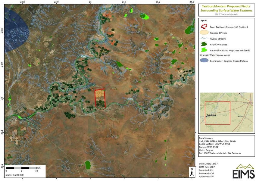
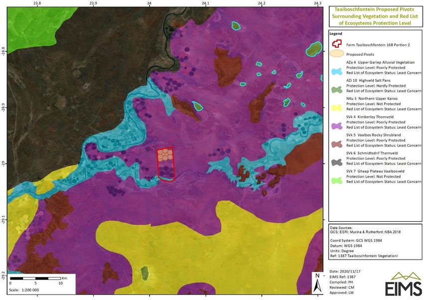
Table of Contents
Executive Summary ................................................................................................................................................ 1
1 Introduction ................................................................................................................................................... 1
 1.1 Report Structure ................................................................................................................................... 1
 1.2 Details of the EAP .................................................................................................................................. 5
 1.3 Expertise of the EAP .............................................................................................................................. 5
2 Description of the property ........................................................................................................................... 6
 2.1 Property Ownership .............................................................................................................................. 6
 2.2 Surrounding land uses ........................................................................................................................... 6
3 Description and Scope of the Propsed Project .............................................................................................. 9
4 Policy and Legislative Context ........................................................................................................................ 9
 4.1 Applicable National Legislation ........................................................................................................... 12
 4.2 Period for which Authorization is Required ........................................................................................ 16
5 Need and Desirability of the Proposed Project ............................................................................................ 17
 5.1 Need and Desirability analysis ............................................................................................................ 17
6 Project Alternatives ..................................................................................................................................... 30
 6.1 PREFERRED ALTERNATIVE ................................................................................................................... 31
 6.2 NO-GO ALTERNATIVE .......................................................................................................................... 31
7 Stakeholder Engagement ............................................................................................................................. 31
 7.1 Legal Compliance ................................................................................................................................ 32
 7.2 General Approach to Public Participation ........................................................................................... 32
 7.3 Identifcation of interested and affected parties ................................................................................. 32
 7.4 Notification of I&Aps. .......................................................................................................................... 33
 7.5 Notification of Availability of Scoping Report ..................................................................................... 34
 7.6 Issues and Responses. ......................................................................................................................... 34
8 Environmental Attributes and Baseline ....................................................................................................... 35
 8.1 Climate ................................................................................................................................................ 35
 8.2 Topography ......................................................................................................................................... 37
 8.3 Geology and Palaeontology ................................................................................................................ 37
 8.4 Heritage ............................................................................................................................................... 37
 8.5 Soil ....................................................................................................................................................... 38
 8.6 Vegetation ........................................................................................................................................... 38
 8.7 Faunal Species ..................................................................................................................................... 40
 8.8 Biodiversity Site Sensitivity ................................................................................................................. 41
 8.9 Surrounding Land Uses and Demographics ........................................................................................ 44
 8.10 Site Specific Photographs .................................................................................................................... 56
9 Environmental Impact Assessment .............................................................................................................. 58
 9.1 Procedure ............................................................................................................................................ 58

1387 Taaiboschfontein Scoping Report i
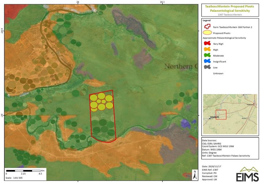
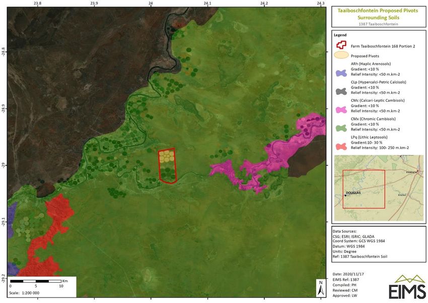
9.2 Identification of Impacts ..................................................................................................................... 62
 9.3 Summary of Preliminary Impacts ........................................................................................................ 74
10 Plan of study for the impact assessment ..................................................................................................... 76
 10.1 Description of Alternatives to be considered...................................................................................... 76
 10.2 Description of the aspects to be assessed as part of the envirnmetnal impact assesment phase ..... 76
 10.3 Aspects to be assessed by specialists .................................................................................................. 76
 10.4 Proposed method for assessing environmental Aspects .................................................................... 76
 10.5 Proposed method for assessing significance ...................................................................................... 76
 10.6 Competent authorities consultation ................................................................................................... 77
 10.7 Proposed method of Public participation ........................................................................................... 77
 10.8 Description of tasks that will be undertaken during the EIA process ................................................. 78
 10.9 Measures to Avoid, Reverse, Mitigate, or Manage Impacts ............................................................... 78
11 Assumptions, Limitations and Uncertainties ............................................................................................... 79
12 Undertakings .................................................................................................................................................. 1
 12.1 Undertaking Regarding Correctness of Information ............................................................................. 1
 12.2 Undertaking Regarding Level of Agreement ......................................................................................... 1
13 References ..................................................................................................................................................... 2

List of Figures
Figure 1: Aerial imagery indicating the proposed pivots site location. .................................................................. 7
Figure 2: Land uses surrounding the proposed pivot area. .................................................................................... 8
Figure 3: EIA process diagram .............................................................................................................................. 14
Figure 4: Authorisation processes for new water uses. ....................................................................................... 15
Figure 5: Monthly average temperature in Kimberley (weatherbase.com, 2021). .............................................. 36
Figure 6: Average monthly precipitation in Kimberley (weatherbase.com, 2021). .............................................. 36
Figure 7:The site sensitivity map of the planned development area showing the planned layout of the new pivots.
 ..................................................................................................................................................................... 43
Figure 8: Regional topography.............................................................................................................................. 46
Figure 9: Project area simplified geology. ............................................................................................................ 47
Figure 10: Extract of the 2824 Kimberley Geological Map. .................................................................................. 48
Figure 11: Palaeontological sensitivity of the project area. ................................................................................. 49
Figure 12: Soil types covering the study area. ...................................................................................................... 50
Figure 13: Study area vegetation. ......................................................................................................................... 51
Figure 14: Specialist identified vegetation type units. ......................................................................................... 52
Figure 15: Surface Water Features Surrounding the proposed project area. ...................................................... 53
Figure 16: Terrestrial Biodiversity Areas............................................................................................................... 54

1387 Taaiboschfontein Scoping Report ii
Figure 17: Important areas surrounding the proposed project site. .................................................................... 55

List of Tables
Table 1: Report Structure ....................................................................................................................................... 1
Table 2: Locality details .......................................................................................................................................... 6
Table 3: Applicable legislation and guidelines overview ........................................................................................ 9
Table 4: Listed activities in terms of the NEMA EIA Regulations (2014) as amended .......................................... 13
Table 5: Needs and desirability analysis for the proposed pivot development. .................................................. 17
Table 6: Summary of issues raised by I&APs ........................................................................................................ 34
Table 7: Monthly average temperature in Kimberley (weatherbase.com, 2021). ............................................... 35
Table 8: Average monthly precipitation in Kimberley (weatherbase.com, 2021). ............................................... 36
Table 9: Protected species that possibly occur on-site. ....................................................................................... 39
Table 10:Alien invasive species that occur in or around the property. ................................................................ 40
Table 11: Bird species of conservation concern identified as occurring in and around the quarter degree squares
 and the potential for occurrence on-site. .................................................................................................... 41
Table 12: Mammal species of conservation concern identified as occurring in and around the quarter degree
 squares and the potential for occurrence on-site. ...................................................................................... 41
Table 13: Table of figures showing photos of the proposed project area. ........................................................... 56
Table 14: Criteria for Determining Impact Consequence. .................................................................................... 58
Table 15: Probability Scoring. ............................................................................................................................... 59
Table 16: Determination of Environmental Risk. .................................................................................................. 60
Table 17: Environmental Risk Scores. ................................................................................................................... 60
Table 18: Criteria for Determining Prioritisation. ................................................................................................. 60
Table 19: Determination of Prioritisation Factor.................................................................................................. 61
Table 20: Final Environmental Significance Rating. .............................................................................................. 61
Table 21: Significance rating of identified impacts ............................................................................................... 75

Appendices
Appendix A: EAP CV

Appendix B: Maps

Appendix C: Public Participation

Appendix D: Specialist Reports

Appendix E: EA Application

Appendix F: DEA Screening Tool Report

Appendix G: Water Use Licence Registration

1387 Taaiboschfontein Scoping Report iii
1387 Taaiboschfontein Scoping Report iv
EXECUTIVE SUMMARY
Genade Boerdery (Pty) Ltd (the applicant) has appointed Environmental Impact Management Services (Pty) Ltd
(EIMS) as the Environmental Assessment Practitioner (EAP) to assist with undertaking the required
Environmental Authorisation (EA) application processes (including the statutory public participation) for the
proposed expansion of farming activities, in the form of additional pivots, on portion 2 of the Farm
Taaiboschfontein 168 (registration division: Kimberley), near Douglas in the Northern Cape. This Scoping Phase
Report is prepared in accordance with the requirements of Appendix 2 of the Environmental Impact Assessment
Regulations, 2014, as part of the National Environmental Management Act (NEMA- Act 107 of 1998).
PURPOSE OF THE SCOPING REPORT
The purpose of the scoping process is to:
 • Identify the policies and legislation that are relevant to the activity;

 • To motivate the need and desirability of the proposed activity, including the need and desirability of
 the activity in the context of the preferred location;

 • To identify and confirm the preferred activity and technology alternative through an impact and risk
 assessment and ranking;

 • Where appropriate, to identify and confirm the preferred site, through a detailed site selection process,
 which includes an impact and risk assessment process including cumulative impacts and a ranking
 process of all the identified alternatives focusing on the geographical, physical, biological, social,
 economic, and cultural aspects of the environment;

 • To identify the key issues to be addressed in the assessment phase;

 • To agree on the level of assessment to be undertaken, including the methodology to be applied, the
 expertise required, as well as the extent of further consultation to be undertaken to determine the
 impacts and risks the activity will impose on the preferred site through the life of the activity, including
 the nature, significance, consequence, extent, duration and probability of the impacts to inform the
 location of the development footprint within the preferred site; and

 • To identify suitable measures to avoid, manage, or mitigate identified impacts and to determine the
 extent of the residual risks that need to be managed and monitored.

PUBLIC PARTICIPATION PROCESS
A Public Participation (PP) Plan has been prepared in accordance with the requirements of the National
Environmental Management Act (Act 107 of 1998-NEMA), and the Directions issued by the Department of
Environment, Forestry and Fisheries (GN 650 of 5 June 2020) in terms of the Disaster Management Act (Act 57
of 2002). The purpose of the PP Plan is to obtain agreement from the relevant Competent Authority on the
public engagement and participation for the abovementioned project. A copy of the plan is available in Appendix
E and is available upon request.

The Public Participation Process for the proposed project has been undertaken in accordance with the
requirements the National Environmental Management Act in line with the principles of Integrated
Environmental Management. The PPP commenced on the 29 September 2020 with an initial notification and
call to register. The comments received from I&APs during the initial call to register and commenting period to
date have been captured in the Public Participation Report in Appendix C, and a summary of the issues raised
and section of this report where issues are addressed is presented in Section 0.
Comments received during this Scoping Report review period will be included in the finalised Scoping Report to
be submitted to the Northern Cape Department of Agriculture, Environmental Affairs, Land Reform and Rural
Development (DAEALRRD). Should the DALRRD accept the Scoping Report, an EIA Report including an

1387 Taaiboschfontein Scoping Report 1
Environmental Management Programme Report, will be compiled and presented for public comment as part of
this EIA phase.
This Scoping Report has been made available for public review and comment for a period of 30 days from the
1st April 2021 until the 5th May 2021. Contact details for EIMS are provided below:
 • Environmental Impact Management Services (Pty) Ltd (EIMS)

 • P.O. Box 2083 Pinegowrie 2123

 • Phone: 011 789 7170 / Fax: 086 571 9047

 • Contact: Cheyenne MuthukarapanD

 • Email: taaiboschfontein@eims.co.za

PROJECT ALTERNATIVES AND ENVIRONMENTAL IMPACT ASSESSMENT
A scoping assessment was undertaken to identify all the potential risks and impacts associated with each phase
of the proposed pivot expansion activities as well as potentially feasible alternatives. After considering the broad
range of alternative types that exist (i.e. location, process, technology, and activity options), no other feasible
alternatives other than the preferred and No-Go alternatives could be identified. Certain incremental
alternatives such as power sourcing to the proposed centre pivot system will be further considered during the
EIA phase.
Background information review on the surrounding areas, the biodiversity and heritage/ palaeontological
specialist assessment reports (Appendix D) as well as the Department of Environment, Forestry and Fisheries
(DEFF) Screening Tool Report (Appendix F) helped to guide the identification of potential impacts. Each of the
identified risks and impacts at the various project phases were assessed. The assessment criteria (See Section 9
for the EIMS Impact Assessment Methodology) include the nature, extent, duration, magnitude / intensity,
reversibility, probability, cumulative impact, and irreplaceable loss of resources.
The most significant risks and impacts identified were those that remain high in terms of significance even post
mitigation measures being considered. The visual impact of the proposed project was rated as having a medium
negative significance and the socio-economic benefit was rated as having a medium positive impact. Additional
impacts identified are listed below. All these impacts were rated as having low significance if mitigation
measures are adhered to (See Section 9.2 for full list of identified impacts and the significance of each):
 • Negative Impacts:
 o Anthropogenic disturbances, intentional and/or accidental killing of fauna.
 o Dust nuisance.
 o Erosion.
 o Fire damage.
 o Habitat fragmentation, loss of natural vegetation and alien invasion in a CBA 2
 o Impact on heritage resources.
 o Littering.
 o Loss of species of conservation concern.
 o Noise nuisance.
 o Oil/ fuel spillages causing soil and groundwater contamination.
 • Positive Impacts:
 o Job Opportunities

1387 Taaiboschfontein Scoping Report 2
The identified potential impacts, where required, will be further assessed during the EIA phase of the project.
Potential mitigation measures have been identified and will be refined based on input from the EAP competent
authority and public consultation. The associated EMPr, drafted during the EIA phase, will identify appropriate
mitigation mechanisms for avoidance, minimisation and / or management of the negative impacts and
enhancement of the positive impacts.

1387 Taaiboschfontein Scoping Report 3
1 INTRODUCTION
Genade Boerdery has appointed Environmental Impact Management Services (Pty) Ltd (EIMS) as the
Environmental Assessment Practitioner (EAP) to assist with undertaking the required application processes
(including the statutory public participation), and to compile and submit the required documentation in support
of application for:
 • Environmental Authorisation (EA) in accordance with the National Environmental Management Act
 (NEMA)- Listed activity:

 o GNR 984: Activity 15: “the clearance of an area of 20 hectares or more of indigenous
 vegetation, excluding where such clearance of indigenous vegetation is required for-

 (i) The undertaking of a linear activity; or

 (ii) Maintenance purposed undertaken in accordance with a maintenance management
 plan.”

The project will involve the clearance of ~450 hectares of indigenous vegetation for the purposes of creating
new cultivation (pivot) areas. This is necessary to allow the farming operation to adequately rotate the potato
cultivation every two years to prevent blight.

The proposed project is located on portion 2 of the Farm Taaiboschfontein 168 (registration division: Kimberly),
located along the R357 from Kimberly to Douglas, in the Siyancuma Local Municipality, Pixley Ka Seme District
Municipality. The site is located approximately 26km north-east of the town Douglas and 77km south-west of
the town Kimberly. The centre point of the site is 28°59'1.90"S and 24°1'41.38"E.

1387 Taaiboschfontein Scoping Report 1
1.1 REPORT STRUCTURE
This report has been compiled in accordance with the 2014 NEMA EIA Regulations, as amended. A summary of the report structure, and the specific sections that correspond
to the applicable regulations, is provided in Table 1 below.
Table 1: Report Structure

 Environmental Regulation Description – NEMA Regulation 982 (2014) as amended Section in Report

 Appendix 2(2)(a): Details of – Section 1.2
 i. The Environmental Assessment Practitioner (EAP) who prepared the report; and Section 1.3
 ii. The expertise of the EAP, including a curriculum vitae;

 Appendix 2(2)(b): The location of the activity. Including – Section 2
 i. The 21-digit Surveyor General code of each cadastral land parcel;
 ii. Where available, the physical address and farm name;
 iii. Where the required information in items (i) and (ii) is not available, the coordinates of the
 boundary of the property or properties;

 Appendix 2(2)(c): A plan which locates the proposed activity or activities applied for at an appropriate scale, or, if it is – Section 2
 i. A linear activity, a description and coordinates of the corridor in which the proposed activity Figure 1
 or activities is to be undertaken; or
 ii. On a land where the property has not been defined, the coordinates within which the activity
 is to be undertaken;

 Appendix 2(2)(d): A description of the scope of the proposed activity, including – Section 3
 i. All listed and specified activities triggered; Table 4
 ii. A description of the activities to be undertaken, including associated structures and
 infrastructure;

 Appendix 2(2)(e): A description of the policy and legislative context within which the development is proposed including Section 4
 an identification of all legislation, policies, plans, guidelines, spatial tools, municipal development

 1387 Taaiboschfontein Scoping Report 1
Environmental Regulation Description – NEMA Regulation 982 (2014) as amended Section in Report
 planning frameworks and instruments that are applicable to this activity and are to be considered in
 the assessment process;

Appendix 2(2)(f): A motivation for the need and desirability for the proposed development including the need and Section 5
 desirability of the activity in the context of the preferred location;

Appendix 2(2)(g): A full description of the process followed to reach the proposed preferred activity, site and location Section 6, 0, 8, 9,
 within the site, including – and 10.
 i. Details of all alternatives considered;
 ii. Details of the public participation process undertaken in terms of regulation 41 of the
 Regulations, including copies of the supporting documents and inputs;
 iii. A summary of the issues raised by interested and affected parties, and an indication of the
 manner in which the issues were incorporated, or the reasons for not including them;
 iv. The environmental attributes associated with the alternatives focusing on the geographical,
 physical, biological, social, economic, heritage and cultural aspects;
 v. The impacts and risks identified for each alternative, including the nature, significance,
 consequence, extent, duration and probability of the impacts, including the degree to which
 these impacts –
 aa. Can be reversed;
 bb. May cause irreplaceable loss or resources; and
 cc. Can be avoided, managed or mitigated;
 vi. The methodology used in determining and ranking the nature, significance, consequences,
 extent, duration and probability of potential environmental impacts and risks associated with
 the alternatives;
 vii. Positive and negative impacts that the proposed activity and alternatives will have on the
 environment and on the community that may be affected focusing on the geographical,
 physical, biological, social, economic, heritage and cultural aspects;
 viii. The possible mitigation measures that could be applied and level of residual risk;
 ix. The outcome of the site selection matrix;
 x. If no alternatives, including alternative locations for the activity were investigated, the
 motivation for not considering such; and
 xi. A concluding statement indicating the preferred alternatives, including preferred location of
 the activity;

 1387 Taaiboschfontein Scoping Report 2
Environmental Regulation Description – NEMA Regulation 982 (2014) as amended Section in Report

Appendix 2(2)(h): A plan of study for undertaking the environmental impact assessment process to be undertaken, Section 10
 including –
 i. A description of the alternatives to be considered and assessed within the preferred site,
 including the option of not proceeding with the activity;
 ii. A description of the aspects to be assessed as part of the environmental impact assessment
 process;
 iii. Aspects to be assessed by specialists;
 iv. A description of the proposed method of assessing the environmental aspects, including a
 description of the proposed method assessing the environmental aspects to be assessed by
 specialists;
 v. A description of the proposed method of assessing duration and significance;
 vi. An indication of the stages at which the competent authority will be consulted;
 vii. Particulars of the public participation process that will be conducted during the environmental
 impact assessment process; and
 viii. A description of the tasks that will be undertaken as part of the environmental impact
 assessment process;
 ix. Identify suitable measures to avoid, reverse, mitigate or manage identified impacts and to
 determine the extent of the residual risks that need to be managed and monitored;

Appendix 2(2)(i) An undertaking under oath or affirmation by the EAP in relation to – Section 12
 i. The correctness of the information provided in the report;
 ii. The inclusion of comments and inputs from stakeholders and interested and affected parties;
 and
 iii. Any information provided by the EAP to interested and affected parties and any responses by
 the EAP to comments or inputs made by interested or affected parties;

Appendix 2(2)(j): An undertaking under oath or affirmation by the EAP in relation to the level of agreement between the Section 12
 EAP and interested and affected parties on the plan of study for undertaking the environmental impact
 assessment;

Appendix 2(2)(k): Where applicable, any specific information required by the competent authority; and No additional
 requirements
 have been

 1387 Taaiboschfontein Scoping Report 3
Environmental Regulation Description – NEMA Regulation 982 (2014) as amended Section in Report
 received from the
 competent
 authority to date.

Appendix 2(2)(l): Any other matter required in terms of section 24(4)(a) and (b) of the Act. No additional
 required matters
 were identified in
 terms of these
 sections of the
 Act.

 1387 Taaiboschfontein Scoping Report 4
1.2 DETAILS OF THE EAP
The contact details of the EIMS consultant who compiled this Scoping Report are as follows:
 • Name of the consultant: Cheyenne Muthukarapan

 • Tel No.: 011 789 7170

 • Fax No.: 086 571 9047

 • E-mail address: taaiboschfontein@eims.co.za

1.3 EXPERTISE OF THE EAP
 EAP QUALIFICATIONS
In terms of Regulation 13 of the EIA Regulations (GN R. 982) as amended, an independent EAP, must be
appointed by the applicant to manage the application. EIMS has been appointed by the Applicant as the EAP to
assist with compiling the necessary reports and undertaking the statutory public participation processes, in
support of the proposed Taaiboschfontein project. EIMS is compliant with the definition of an EAP as defined in
Regulations 1 and 13 of the EIA Regulations, as well as Section 1 of the NEMA. This includes, inter alia, the
requirement that EIMS is:
 • Objective and independent;
 • Has expertise in conducting EIA’s;
 • Comply with the NEMA, the environmental regulations and all other applicable legislation;
 • Considers all relevant factors relating to the application; and
 • Provides full disclosure to the applicant and the relevant environmental authority.
The Curriculum Vitae (indicating the experience with environmental impact assessment and relevant application
processes) of the consultant that is involved in the EIA process and the compilation of this Scoping Report is
presented in Appendix A.

 SUMMARY OF THE EAP’S PAST EXPERIENCE
EIMS is a private and independent environmental management-consulting firm that was founded in 1993. EIMS
has in excess of 25 years’ experience in conducting EIA’s. Please refer to the EIMS website (www.eims.co.za) for
examples of EIA documentation currently available.
Cheyenne Muthukarapan is a consultant at EIMS and has been involved in core aspects of numerous
environmental impact assessment projects the past 4 years that she has been with the company. Her expertise
lies in public consultation/participation processes and sustainability consulting. She has participated in
numerous public/stakeholder consultations in relation to environmental impacts assessments, and the
formulation of sustainable solutions to various environmental problems for a wide array of projects ranging from
risk assessments, audits, EIAs and Basic Assessments for mining, gas exploration, wetland rehabilitation, road
upgrades, etc.

 SPECIALIST CONSULTANTS
Biodiversity and Heritage were the only pre-identified specialist study that was deemed essential by the EAP and
conducted during the scoping phase of this project. Additional specialist studies that were identified through
use of the Department of Environmental Affairs’ Screening Tool were:
 • Landscape/visual Impact Assessment

 • Socio-Economic Impact Assessment

1387 Taaiboschfontein Scoping Report 5
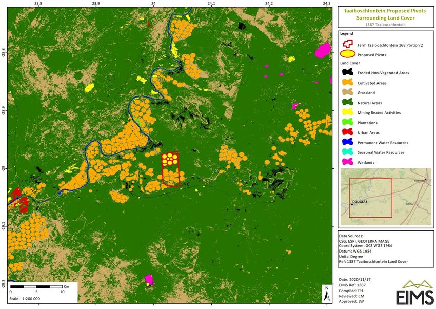
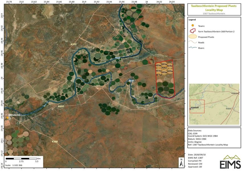
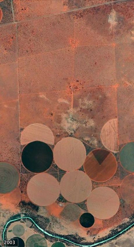
In terms of section 24(5)(h) of the NEMA, 1998 (Act No 107 of 1998) and regulation 16(1)(b)(v) of the EIA
regulations, 2014, as amended, the required DEA Screening Report is provided as part of Appendix F. The above-
mentioned specialist studies as identified through the tool were deemed by the EAP because of the proposed
location and type of activities which form part of the farm expansion project. These specialist studies were
deemed unnecessary by the EAP after a desktop thus disregarded during the scoping phase of this project.
The biodiversity and heritage and palaeontological specialist studies involved the gathering of data relevant to
identifying and assessing preliminary environmental impacts that may occur as a result of the proposed pivots.
These preliminary impacts were assessed according to the EIMS pre-defined impact significance rating
methodology (Section 9). The specialists have also included recommendations preliminary mitigation/
management or optimisation measures to minimise potential negative impacts or enhance potential benefits,
respectively. The specialist’s declaration of independence is included in the specialist report presented in
Appendix D.

2 DESCRIPTION OF THE PROPERTY
Table 2 provides a description of the property details and size of the proposed pivots footprint as well as the
distance to the nearest towns. Refer Figure 1 for the locality of the proposed pivots.
Table 2: Locality details
 Property Farm Taaiboschfontein 168 Portion 2

 21-digit Surveyor C03700000000016800002
 General Code

 Application Area (Ha) The directly affected property (portion 2) comprises an area of 1713.0640 ha. The
 estimated combined area of the proposed pivots is approximately 456 ha.
 Magisterial District Ward 6 of the Siyancuma Local Municipality, Pixley Ka Seme District Municipality

 Distance and
 The proposed project is located on portion 2 of the Farm Taaiboschfontein 168
 direction from (registration division: Kimberly), located along the R357 from Kimberly to Douglas, in
 nearest towns the Siyancuma Local Municipality, Pixley Ka Seme District Municipality. The site is
 located approximately 26km north-east of the town Douglas and 77km south-west
 of the town Kimberly. The centre point of the site is 28°59'1.90"S and 24°1'41.38"E.

2.1 PROPERTY OWNERSHIP
As stated above, the proposed pivots will be located on portion 2 of the farm Taaiboschfontein 168 located along
the R357. This property is currently registered under the Vickie Trust which is owned by the applicant. Refer to
Figure 1 for the locality of the proposed development of pivots.

2.2 SURROUNDING LAND USES
The area immediately surrounding the proposed pivots development footprint can be described as combination
of natural indigenous vegetation and transformed cultivated areas (pivots) located along the Riet and Vaal
Rivers. The existing pivots for the applicant are situated south of the proposed pivots, just north of the Riet River.
The property is located along the R357 from the town of Douglas to Kimberly.
On a regional scale, the town of Douglas is the closest major town located 26 km to the west-south-west of the
proposed pivots. Refer to Figure 2 for a map of the landcover of the area of the proposed pivots.

1387 Taaiboschfontein Scoping Report 6
Figure 1: Aerial imagery indicating the proposed pivots site location.

 1387 Taaiboschfontein Scoping Report 7
Figure 2: Land uses surrounding the proposed pivot area.

 1387 Taaiboschfontein Scoping Report 8
3 DESCRIPTION AND SCOPE OF THE PROPSED PROJECT
The section below provides a detailed description for the proposed pivots. The aim of the project description is
designed to facilitate the understanding of the proposed project related activities which are anticipated to lead
to the preliminary impacts identified and assessed in this Scoping Report, and for which mitigation measures
have been, or will be designed.
The proposed project involves the clearance of approximately 450 hectares of indigenous vegetation for the
purposes of creating new cultivation (pivot) areas for the growing of potatoes. The proposed project will include
the implementation of 1 pivot annually. Each pivot will be operational for two consecutive years upon which the
soil will be returned to its natural inhabitation, cultivation will move on to the next pivot area and the cycle will
repeat itself every 8 years for all pivots. Each pivot will be used to produce and harvest seed potatoes. It is
necessary to allow the farming operation to adequately rotate the potato cultivation every two years to prevent
blight (a potato fungal infection).

4 POLICY AND LEGISLATIVE CONTEXT
This section provides an overview of the governing legislation identified which may relate to the proposed
project. A summary of the applicable legislation is provided in Table 3 below. The primary legal requirement for
this project stems from the need for an EA to be granted by the competent authority, NCAEALRRD in accordance
with the requirements of the NEMA. In addition, there are numerous other pieces of legislation governed by
many acts, regulations, standards, guidelines and treaties on an international, national, provincial and local level,
which should be considered in order to assess the potential applicability of these for the proposed project. More
detail on the legislative framework is presented below.
Table 3: Applicable legislation and guidelines overview
 Applicable Legislation, Policies Description of Legislation, Policy Relevance to the Proposed
 and Guidelines or Guideline Project
 Constitution of the Republic of The constitution of any country is This EIA is conducted to fulfil the
 South Africa (Act 108 of 1996) the supreme law of that country. requirement of the Bill of Rights.
 The Bill of Rights in chapter 2
 section 24 of the Constitution of
 South Africa Act (Act 108 of 1996)
 makes provisions for
 environmental issues and
 declares that: “Everyone has the
 right -
 a) to an environment that is not
 harmful to their health or well-
 being; and
 b) to have the environment
 protected, for the benefit of
 present and future
 c) generations, through
 reasonable legislative and other
 measures that:

1387 Taaiboschfontein Scoping Report 9
Applicable Legislation, Policies Description of Legislation, Policy Relevance to the Proposed
 and Guidelines or Guideline Project
 i. prevent pollution and ecological
 degradation;
 ii. promote conservation; and
 iii. secure ecologically sustainable
 development and use of natural
 resources while promoting
 justifiable economic and social
 development”.
 National Environmental The NEMA (1998) requires that a Activities that triggered the need
 Management Act (Act 107 of project of this nature must for an EIA process to be followed
 1998 – NEMA); and the EIA undergo a Scoping and are:
 Regulations (2014, as amended) Environmental Impact • GN R. 984, Listing Notice 2,
 Assessment (EIA); an Activity 15
 Environmental Management
 Programme (EMPr) must also be
 compiled. Regulations applicable
 to this project include the
 following:
 • EIA Regulations GN R. 982
 (2014, as amended) in terms of
 the NEMA;
 • EIA Regulations GN R. 983
 (2014, as amended) in terms of
 the NEMA;
 • EIA Regulations GN R. 984
 (2014, as amended) in terms of
 the NEMA; and
 National Water Act (Act 36 of The NWA recognises that water is It is understood that the
 1998 – NWA a scarce and unevenly distributed proposed project is already
 national resource which must be covered under the existing water
 managed encompassing all use licence for the existing pivots.
 aspects of water resources. If any water use authorisation is
 required an application will be
 lodged with the Department of
 Human Settlements, Water and
 Sanitation.

1387 Taaiboschfontein Scoping Report 10
Applicable Legislation, Policies Description of Legislation, Policy Relevance to the Proposed
 and Guidelines or Guideline Project
 National Heritage Resources Act, The National Heritage Resources Due to the extent of the project,
 1999 (Act no 25 of 1999) Act aims to promote good it is possible that some heritage
 management of cultural heritage resources and palaeontological
 resources and encourages the features are likely to occur within
 nurturing and conservation of the project boundary area. This
 cultural legacy so that it may be will be assessed by the Heritage
 bestowed to future generations. and Palaeontological specialists.

 National Environmental The National Environmental The project will involve the
 Management: Biodiversity Act Management: Biodiversity Act clearance of ~450 hectares of
 (NEM:BA) (Act 10 of 2004) (Act 10 of 2004) (NEMBA) indigenous vegetation for the
 provides for listing threatened or purposes of creating new
 protected ecosystems, in one of cultivation (pivot) areas. It is
 four categories: critically possible that sensitive species
 endangered (CR), endangered could be located in the proposed
 (EN), vulnerable (VU) or project and area. A TOPS permit is
 protected. NEM:BA also deals required for any activities
 with endangered, threatened and involving any TOPS species.
 otherwise controlled species,
 under the Threatened or
 Protected Species Regulations
 (TOPS)

 National Forests Act (No. 84 of The National Forests Act provides A permit will be required should a
 1998): for the protection of forests as protected tree species be
 well as specific tree species. required to be destroyed,
 transported or transplanted.

 National Veld and Forest Fire Act The purpose of this Act is to The proposed project area is
 (Act No. 101 of prevent and combat veld, forest situated in the amongst natural
 and mountain fires. indigenous vegetation and
 cultivated land. It is important to
 ensure that the necessary
 precautionary measures are
 included in EMPR in case of fires.

 Conservation of Agricultural The Conservation of Agricultural The proposed project area is
 Resources Act (Act 43 of 1983): Resources Act provides for the situated in the amongst natural
 regulation of control over the indigenous vegetation and

1387 Taaiboschfontein Scoping Report 11
Applicable Legislation, Policies Description of Legislation, Policy Relevance to the Proposed
 and Guidelines or Guideline Project
 utilisation of the natural cultivated land. It is important to
 agricultural resources in order to ensure that the necessary
 promote the conservation of soil, precautionary measures are
 water and vegetation and included in EMPR in order to
 provides for combating weeds conserve the soils and vegetation
 and invader plant species. and to protect the proposed
 footprint area against combating
 weeds and invader species.

 Northern Cape Nature The Northern Cape Nature The proposed project area is
 Conservation Act, Act No 9. Of Conservation Act provides inter situated amongst natural
 2009 alia for the sustainable utilisation indigenous vegetation and
 of wild animals, aquatic biota and cultivated land. A permit may be
 plants as well as permitting and required by the DENC office in
 trade regulations regarding wild Kimberly for the site clearing.
 fauna and flora within the
 A permit would also be required
 province.
 to destroy or translocate any
 nationally or provincially listed
 species from the site.

4.1 APPLICABLE NATIONAL LEGISLATION
The legal framework within which the proposed pivots is governed by many Acts, Regulations, Standards and
Guidelines on an international, national, provincial and local level. Legislation applicable to the project includes
(but is not limited to) those discussed below.

 THE NATIONAL ENVIRONMENTAL MANAGEMENT ACT (NEMA)
The main aim of the National Environmental Management Act, 1998 (Act 107 of 1998 – NEMA) is to provide for
co-operative governance by establishing decision-making principles on matters affecting the environment. In
terms of the NEMA EIA Regulations, the applicant is required to appoint an EAP to undertake the EIA process,
as well as conduct the public participation process towards an application for EA. In South Africa, EIA’s became
a legal requirement in 1997 with the promulgation of regulations under the Environment Conservation Act (ECA),
NEMA was passed in 1998. Section 24(2) of NEMA empowers the Minister and any MEC, with the concurrence
of the Minister, to identify activities which must be considered, investigated, assessed and reported on to the
competent authority responsible for granting the relevant EA. On 21 April 2006, the Minister of Environmental
Affairs and Tourism (now DEA) promulgated regulations in terms of Chapter 5 of the NEMA. These regulations,
in terms of the NEMA, were amended in June 2010 and again in December 2014 as well as April 2017. The 2014
NEMA EIA Regulations (as amended) are applicable to this project.
The objective of the EIA Regulations is to establish the procedures that must be followed in the consideration,
investigation, assessment and reporting of the listed activities that have been identified as applicable by the
proposed development. The purpose of these procedures is to provide the competent authority with adequate
information to make decisions which ensure that activities which may impact negatively on the environment to

1387 Taaiboschfontein Scoping Report 12
an unacceptable degree are not authorised, and that activities which are authorised are undertaken in such a
manner that the environmental impacts are managed to acceptable levels.
In accordance with the provisions of Sections 24(5) and Section 44 of the NEMA the Minister has published
Regulations (GN R. 982) pertaining to the required process for conducting EIA’s in order to apply for, and be
considered for, the issuing of an EA. These EIA Regulations provide a detailed description of the EIA process to
be followed when applying for EA for any listed activity. The Regulations differentiate between a simpler Basic
Assessment Process (required for activities listed in GN R. 983 and GN R. 985) and a more complete EIA process
(activities listed in GN R. 984). In the case of the proposed calcination plant project, there are activities triggered
under GN R. 984 and as such a full EIA process is necessary. Table 4 presents all the anticipated listed activities
under the NEMA 2014 EIA Regulations (as amended) that are applicable to this project.
Table 4: Listed activities in terms of the NEMA EIA Regulations (2014) as amended
 Name of activity Aerial extent of the activity Applicable listing notice

 Environmental Authorisation ~ 456 ha NEMA GN R. 984 (Listing Notice 2), Activity 15

An environmental Scoping and Impact Assessment process is reserved for activities which have the potential to
result in significant impacts which are complex to assess. Scoping and Impact Assessment studies accordingly
provide a mechanism for the comprehensive assessment of activities that are likely to have more significant
environmental impacts. Figure 3 below provides a graphic representation of all the components of a full EIA
process.

1387 Taaiboschfontein Scoping Report 13
Figure 3: EIA process diagram

1387 Taaiboschfontein Scoping Report 14
THE NATIONAL WATER ACT (NWA)
The National Water Act, 1998 (Act 36 of 1998 – NWA) makes provision for two types of applications for water
use licences, namely individual applications and compulsory applications. The NWA also provides that the
responsible authority may require an assessment by the applicant of the likely effect of the proposed licence on
the resource quality, and that such assessment be subject to the NEMA EIA Regulations. A person may use water
if the use is:
 • Permissible as a continuation of an existing lawful water use (ELWU);
 • Permissible in terms of a general authorisation (GA);
 • Permissible under Schedule 1; or
 • Authorised by a licence.
These water use processes are described in Figure 4 below.

Figure 4: Authorisation processes for new water uses.

The NWA defines 11 water uses. A water use may only be undertaken if authorised by the DHSWS. Water users
are required to register certain water uses that took place on the date of registration, irrespective of whether
the use was lawful or not. The water uses for which an authorisation or licence can be issued include:
 • Taking water from a water resource;
 • Storing water;
 • Impeding or diverting the flow of water in a watercourse;
 • Engaging in a stream flow reduction activity contemplated in section 36;
 • Engaging in a controlled activity identified as such in section 37(1) or declared under section 38(1);
 • Discharging waste or water containing waste into a water resource through a pipe, canal, sewer, sea
 outfall or other conduits;
 • Disposing of waste in a manner which may detrimentally impact on a water resource;
 • Disposing in any manner of water which contains waste from, or which has been heated in, any
 industrial or power generation process;
 • Altering the bed, banks, course or characteristics of a watercourse;
 • Removing, discharging or disposing of water found underground if it is necessary for the efficient
 continuation of an activity or for the safety of people; and

1387 Taaiboschfontein Scoping Report 15
• Using water for recreational purposes.
No further water use authorisation should be required for the proposed project as water to be used on the farm
was already listed with the Oranje Riet Water Users Association on 13 August 2020 for 11 000 m3/ha (See
Appendix G for the certificate of enrolment).

 THE NATIONAL HERITAGE RESOURCES ACT
The National Heritage Resources Act (NHRA) (Act 25 of 1999) stipulates that cultural heritage resources may not
be disturbed without authorization from the relevant heritage authority. Section 34(1) of the NHRA states that,
“no person may alter or demolish any structure or part of a structure which is older than 60 years without a
permit issued by the relevant provincial heritage resources authority…”. The last few years have seen a
significant change towards the inclusion of heritage assessments as a major component of Environmental
Impacts Processes required by NEMA. This change requires us to evaluate the Section of these Acts relevant to
heritage (Fourie, 2008b):
The NEMA 23(2)(b) states that an integrated environmental management plan should, “…identify, predict and
evaluate the actual and potential impact on the environment, socio-economic conditions and cultural heritage”.
A study of subsections (23)(2)(d), (29)(1)(d), (32)(2)(d) and (34)(b) and their requirements reveals the
compulsory inclusion of the identification of cultural resources, the evaluation of the impacts of the proposed
activity on these resources, the identification of alternatives and the management procedures for such cultural
resources for each of the documents noted in the Environmental Regulations. A further important aspect to be
taken account of in the Regulations under NEMA is the Specialist Report requirements laid down in Section 33
(Fourie, 2008b).

 THE SPATIAL PLANNING AND LAND USE MANAGEMENT ACT (SPLUMA)
The Spatial Planning and Land Use Management (Act 16 of 2013 – SPLUMA) is set to aid effective and efficient
planning and land use management, as well as to promote optimal exploitation of minerals and mineral
resources. The SPLUMA was developed to legislate for a single, integrated planning system for the entire
country. Therefore, the Act provides a framework for a planning system for the country and introduces
provisions to cater for development principles; norms and standards; inter-governmental support; Spatial
Development Frameworks (SDFs) across national, provincial, regional and municipal areas; Land Use Schemes
(LUS); and municipal planning tribunals.

 NATIONAL DUST CONTROL REGULATIONS
Dustfall is assessed for nuisance impact and not for inhalation health impact. The National Dust Control
Regulations (Department of Environmental Affairs, 2013) prescribes measures for the control of dust in
residential and non-residential areas. Acceptable dustfall rates are measured (using American Standard Testing
Methodology at and beyond the boundary of the premises where dust originates. In addition to the dustfall
limits, the National Dust Control Regulations prescribe monitoring procedures and reporting requirements.

 ENVIRONMENT CONSERVATION ACT (ECA)
The Environment Conservation Act (Act 73 of 1989 – ECA) was, prior to the promulgation of the NEMA, the
backbone of environmental legislation in South Africa. To date the majority of the ECA has been repealed by
various other Acts, however Section 25 of the Act and the Noise Regulations (GN R. 154 of 1992) promulgated
under this section are still in effect. These Regulations serve to control noise and general prohibitions relating
to noise impact and nuisance.

4.2 PERIOD FOR WHICH AUTHORIZATION IS REQUIRED
The authorisation will be required for the duration of the agricultural activities on-site.

1387 Taaiboschfontein Scoping Report 16
5 NEED AND DESIRABILITY OF THE PROPOSED PROJECT
This section will examine the need and desirability of the proposed pivots and the importance of the project for
the applicants continued operations and as a local economic stimulus. The proposed pivots will allow for
favourable economic impacts on both the local and regional economy. The proposed pivots are consistent with
the surrounding land use activities which is largely agricultural. Should the project proceed, an additional 200
temporary/seasonal jobs are anticipated to be created over a period of 20 years.
Furthermore, the additional pivots will ensure the sustained continuity of the applicants’ operations and guard
the crops against disease. The proposed new pivot developments will allow for the implementation of 1 pivot
annually. Each pivot will be operational for two consecutive years upon which the soil will be returned to its
natural inhabitation. After 8 years the cycle will repeat itself.
Pivot rotation is necessary in order to control lice in order to keep viruses at bay and to prevent early or late rust
caused by fungi1.

5.1 NEED AND DESIRABILITY ANALYSIS
The needs and desirability analysis component of the “Guideline on need and desirability in terms of the
Environmental Impact EIA Regulations (Notice 819 of 2014)” includes, but is not limited to, describing the
linkages and dependencies between human well-being, livelihoods and ecosystem services applicable to the
area in question, and how the proposed development’s ecological impacts will result in socio-economic impacts
(e.g. on livelihoods, loss of heritage sites, opportunity costs, etc.). Table 5 below presents the needs and
desirability analysis undertaken for the proposed pivot development.
Table 5: Needs and desirability analysis for the proposed pivot development.
 Ref No. Question Answer
 1 Securing ecological sustainable development and use of natural resources
 1.1 How were the ecological integrity After running the DEA screening tool (Appendix F),
 considerations taken into account in terms specialist studies that were identified included:
 of: Threatened Ecosystems, Sensitive and
 • Landscape/ Visual Impact Assessment;
 vulnerable ecosystems, Critical Biodiversity
 Areas, Ecological Support Systems, • Archaeological and Cultural Heritage
 Conservation Targets, Ecological drivers of Impact Assessment;
 the ecosystem, Environmental Management
 Framework, Spatial Development • Palaeontology Impact Assessment;
 Framework (SDF) and global and • Terrestrial Biodiversity Impact assessment;
 international responsibilities.
 • Aquatic Biodiversity Impact Assessment;
 • Avian Impact Assessment;
 • Socio-economic Impact Assessment;
 • Plant Species Assessment; and
 • Animal Species Assessment.
 After further desktop analysis of the proposed
 project area, as well as a site visit, only a biodiversity
 and heritage and palaeontological was considered
 necessary by the EAP and was conducted by the
 required specialists. The decision of required
 specialist studies was informed based on the
 location of the proposed project, and the nature of
 the activity. The proposed project area is natural

1
 https://www.farmersweekly.co.za/crops/field-crops/potato-farmers-virgin-soil-strategy-to-reduce-disease-
risk/

1387 Taaiboschfontein Scoping Report 17
You can also read