BOSQUES DEL URUGUAY AFFORESTATION THROUGH HIGH QUALITY TIMBER IN GRASSLANDS PROJECT
←
→
Page content transcription
If your browser does not render page correctly, please read the page content below
PROJECT DESCRIPTION: VCS Version 3

             BOSQUES DEL URUGUAY
          AFFORESTATION THROUGH HIGH
          QUALITY TIMBER IN GRASSLANDS
                     PROJECT

                            Document Prepared By
                                                             ProSustentia

       Project Title   Bosques del Uruguay Afforestation through High Quality Timber in Grasslands Project

           Version     04

   Date of Issue       25/04/2017

       Prepared By     ProSustentia

           Contact     Dr. José Scosería 2699/602, C.P.: 11300, Montevideo, Uruguay
                       Tel: +598 99705146
                       atorchelo@prosustentia.com; fmoyano@prosustentia.com
                       www.prosustentia.com

v3.3                                                                                                     1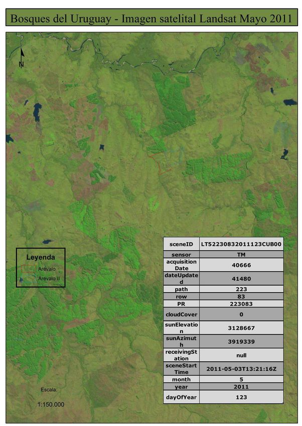
PROJECT DESCRIPTION: VCS Version 3

Table of Contents

1      Project Details ................................................................................................................................. 3
    1.1    Summary Description of the Project .......................................................................................... 3
    1.2    Sectoral Scope and Project Type ............................................................................................. 4
    1.3    Project Proponent .................................................................................................................... 4
    1.4    Other Entities Involved in the Project ........................................................................................ 4
    1.5    Project Start Date ..................................................................................................................... 5
    1.6    Project Crediting Period............................................................................................................ 5
    1.7    Project Scale and Estimated GHG Emission Reductions or Removals ...................................... 5
    1.8    Description of the Project Activity ............................................................................................. 7
    1.9    Project Location ..................................................................................................................... 10
    1.10      Conditions Prior to Project Initiation .................................................................................... 12
    1.11      Compliance with Laws, Statutes and Other Regulatory Frameworks ................................... 13
    1.12      Ownership and Other Programs ......................................................................................... 13
       1.12.1 Project ownership ........................................................................................................... 13
       1.12.2 Emissions Trading Programs and Other Binding Limits ................................................... 13
       1.12.3 Other Forms of Environmental Credit .............................................................................. 13
       1.12.4 Participation under Other GHG Programs ....................................................................... 13
       1.12.5 Projects Rejected by Other GHG Programs .................................................................... 13
    1.13      Additional Information Relevant to the Project ..................................................................... 13
2      Application of Methodology ........................................................................................................... 18
    2.1    Title and Reference of Methodology ....................................................................................... 18
    2.2    Applicability of Methodology ................................................................................................... 18
    2.3    Project Boundary.................................................................................................................... 33
    2.4    Baseline Scenario .................................................................................................................. 36
    2.5    Additionality............................................................................................................................ 48
    2.6    Methodology Deviations ......................................................................................................... 53
3      Quantification of GHG Emission Reductions and Removals ........................................................... 53
    3.1    Baseline Emissions ................................................................................................................ 53
    3.2    Project Emissions ................................................................................................................... 55
    3.3    Leakage ................................................................................................................................. 64
    3.4    Net GHG Emission Reductions and Removals ....................................................................... 65
4      Monitoring ..................................................................................................................................... 67
    4.1    Data and Parameters Available at Validation .......................................................................... 67
    4.2    Data and Parameters Monitored ............................................................................................. 71
    4.3    Monitoring Plan ...................................................................................................................... 74
5      Safeguards ................................................................................................................................... 78
    5.1    No Net Harm .......................................................................................................................... 78
    5.2    Environmental Impact ............................................................................................................. 80
    5.3    Local Stakeholder Consultation .............................................................................................. 82
    5.4    Public Comments ................................................................................................................... 84

v3.3                                                                                                                                                    2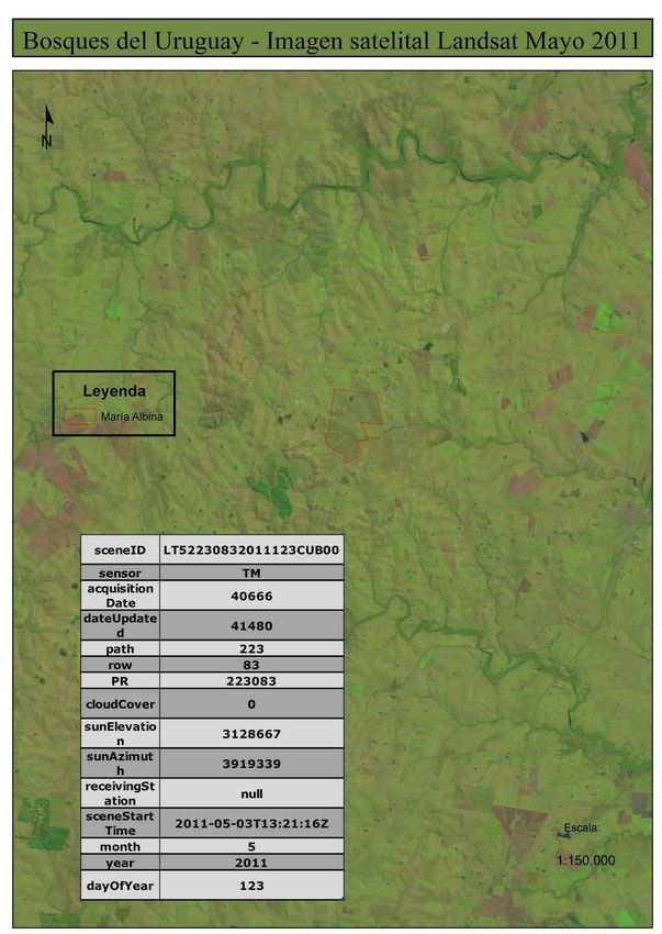
PROJECT DESCRIPTION: VCS Version 3

1      PROJECT DETAILS

1.1     Summary Description of the Project

The proposed VCS project activity “Bosques del Uruguay Afforestation through High Quality Timber in
Grasslands Project” (hereafter, “BDU project”) is an afforestation project on extensive cattle grazing
pastures areas using exotic species (Eucalyptus grandis and dunnii) aiming to produce, as a priority
product, high quality logs for sawmill industry and secondarily, biomass for energy and/or pulp.

The BDU project is a subgroup of lands within BDU trust fund total plots. BDU trust fund comprises 14
properties or plots located in the Central East region of Uruguay (the host country), with a total area of
9,528 ha of which, 5,826 ha are effectively planted. The unplanted area, 3,702 ha, remaining in part as
natural grasslands, are used for cattle grazing and flora and fauna conservation. Part of BDU trust fund
effectively planted area, 2,809 ha that corresponds to 3 entire plots and 85% of a forth plot, had already
established plantations when the project started. Therefore, they are excluded from the VCS project
boundary.

Due to the above, BDU project area corresponds to 3,017 ha effectively planted in 11 plots (10 entire
plots and 15% of the 11th one).

E. grandis occupies 66% of the planted area within the project boundary and the remaining 34% is
occupied by E. dunnii. E. grandis is managed in 18-year rotation periods with an initial planting density of
1,000 trees/ha, thinning in years 2, 9 and 14 leaving 200 trees/ha and pruning in four stages up to 9
meters. Whereas E. dunnii has an initial planting density of 1,333 trees/ha, 9-year rotation periods with
no pruning or thinning. Plantation has been completed in five years: 2012 until 2016. For E. dunnii
plantations a coppicing management is practiced to obtain a second rotation (9 years each). For E.
grandis only one rotation (18 years) will be carried out. Once these 18-year cycles are finished new ones
will be started by replanting the area and repeating the process until a project lifetime of 100 years is
reached.

The project sequesters CO2 through forest plantation in grassland areas, generating net anthropogenic
removals by sinks. The long-term average GHG benefit (LA) is determined by averaging the expected
total GHG benefit for the length of the project (60 years: from 30/05/2012 – until 29/05/2072). The total
GHG benefit for the length of the project is 41,396,999 tCO2e, when divided by 60 years results in
689,950 tCO2e.

The financing of the project is achieved through a Trust fund that invests in land, forestry plantation and
management activities. This is the first forestry trust fund of public offer receiving resources from local
pension funds (AFAPs) in Uruguay. These investors look for safe and predictable rates of return wherein
carbon certification is a plus to guarantee these attributes.

The project contributes to the sustainable development of Uruguay, specifically by:

• Increasing labour demand from the local population: the common activity developed in the project
  region is cattle breeding. Besides the forestry plantation activities, the project will maintain the cattle
  rising both on the unplanted area and under its plantations from year 2 to the end (many local
  researchers support cattle breading inside forests as animals suffer less temperature stress and for
  storms protection). This will generate a much larger demand of labour when compared to these
  activities being developed separately.

• Adding value to wood products and diversifying the regional production will lead to higher economic
  revenues for the region.

v3.3                                                                                                            3
PROJECT DESCRIPTION: VCS Version 3
• Promoting an integrated management scheme with the ecosystem. In this sense, it already obtained
  the necessary approval from the DINAMA (National Directorate of Environment)1 and the plantations
  are certified under the FSC standard.

• Creating and developing a new mechanism to finance projects in the forestry sector.

1.2    Sectoral Scope and Project Type

• Sectoral scope: 14 (Agriculture, Forestry, Land Use)
• Category: Afforestation, Reforestation and Revegetation (ARR)
• Activity type: establishment of forests on land that had previously been under grassland for more than
  50 years.
• BDU Project is a single GHG Project.

1.3    Project Proponent

The project is proposed by Agroempresa Forestal on behalf of “Fideicomiso Financiero Forestal Bosques
del Uruguay” (Trust Fund from now on), owner of the land and project sponsor.

Contact information:

          Organization name        Agroempresa Forestal S.A. (AF)

          Contact person           Dan Guapurá

          Title                    Mr.

          Address                  Juncal 1437 Of. 701; Montevideo - Uruguay

          Telephone                +598 2916 2020

          Email                    dguapura@af.com.uy

1.4    Other Entities Involved in the Project

          Organization name        EF Asset Management (EFAM)

          Role in the project      Trustee of Bosques del Uruguay Trust Fund

          Contact person           -

          Title                    -

          Address                  Avenida Luis Alberto de Herrera 1248

          Telephone                +598 26230000

          Email                    efam@ferrere.com

1
 By the time of submission of this PD to the validating entity (17/04/2017) only one cadastral unit of a plot, that
corresponds to an extension, is waiting for DINAMA Resolution. Refer to section 5.

v3.3                                                                                                                  4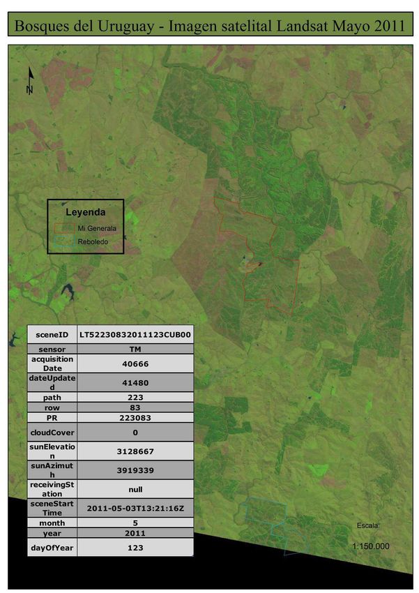
PROJECT DESCRIPTION: VCS Version 3
BDU Project is operated and administered by Agroempresa Forestal (AF) on behalf of “Fideicomiso
Financiero Forestal Bosques del Uruguay” (the trust fund). Besides being the project administrator and
manager, AF is the trust fund administrator. Through a Service Agreement, the Trustee (EFAM) appoints
the Administrator (AF), to fulfill the task of managing the trust assets and carry on the implementation of
the Business Plan. Notwithstanding this, the Trustee maintains responsibility for the management of the
Administrator tasks outsourced to it. This is reflected on the BDU Trust Fund Prospect2 document.
Besides this document, the Trustee EFAM has granted a special power of attorney to the Administrator
AF to act in the name of EFAM to carry on all operational and commercial activities related to the project.
Among these activities are the necessary tasks to certify the carbon credits that could be generated with
BDU project. Once issued, the carbon credits will belong to the Trust Fund as the project harvested wood
does.3

1.5    Project Start Date

30/05/2012

Is the date when the activities that lead to the generation of GHG emission removals (weed control in
“Don Ramón” plot) were first implemented.4

1.6    Project Crediting Period

Project crediting period: 60 years (although   the project lifetime will be of 100 years)

Start date:30/05/2012

End date: 29/05/2072

1.7    Project Scale and Estimated GHG Emission Reductions or Removals

         Project Scale
         Project                                X
         Large project

2
  BDU Trust Fund Prospectus; 15/06/2011; Page 81. Available at:
http://www.bosquesdeluruguay.com/documentos.php. Signed copy available at Central Bank of Uruguay web
page; Route of access: BCU/Sistema Financiero/Mercado de VAlores/Instituciones/Administración de Fondos de
Inversión/EF Asset Management/Productos/Forestal Bosques del Uruguay/Ver documentos/Prospecto
Informativo; http://www.bcu.gub.uy/Servicios-Financieros-SSF/Paginas/InformacionInstitucion.aspx?nroinst=2404
3
  The power of attorney is available to the VVB at validation.
4
  Bill from Guyunusa & Cia. Ltda. to BDU that evidence the woks at Don Ramón plot. Available to the VVB at
validation.

v3.3                                                                                                        5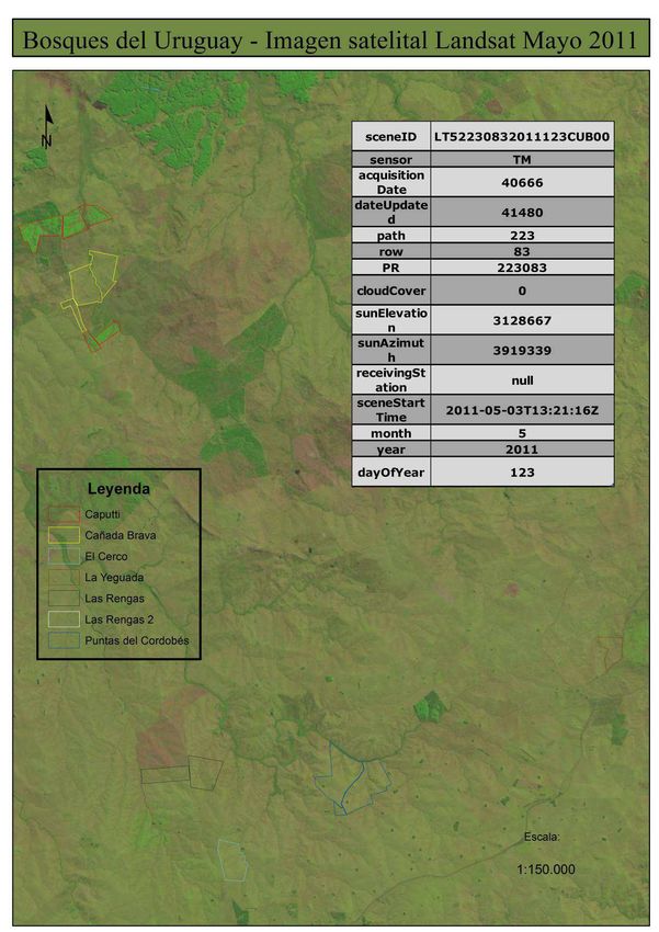
PROJECT DESCRIPTION: VCS Version 3
                                   Estimated GHG emission
                    Year
                                reductions or removals (tCO2e)
       2012 (from 30/05/2012)                  0
       2013                                -41,716
       2014                                 -5,568
       2015                                88,377
       2016                                121,868
       2017                                179,233
       2018                                182,615
       2019                                159,797
       2020                                160,441
       2021                                117,567
       2022                               -141,861
       2023                                -85,697
       2024                                100,041
       2025                                123,749
       2026                                101,361
       2027                                12,115
       2028                                49,201
       2029                                129,114
       2030                                134,666
       2031                               -642,758
       2032                               -574,501
       2033                               -100,133
       2034                                24,908
       2035                                70,141
       2036                                179,233
       2037                                182,615
       2038                                159,797
       2039                                160,441
       2040                                117,567
       2041                               -141,861
       2042                                -85,697
       2043                                100,041
       2044                                123,749
       2045                                101,361
       2046                                12,115
       2047                                49,201
       2048                                129,114
       2049                                134,666
       2050                               -642,758
       2051                               -574,501
       2052                               -100,133
       2053                                24,908
       2054                                70,141
       2055                                179,233
       2056                                182,615
       2057                                159,797
       2058                                160,441
       2059                                117,567
       2060                               -141,861
       2061                                -85,697
       2062                                100,041

v3.3                                                             6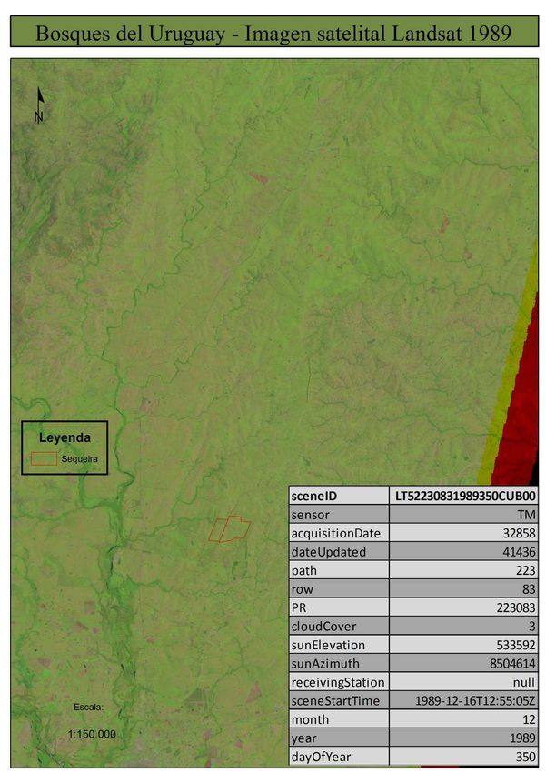
PROJECT DESCRIPTION: VCS Version 3
             2063                                                   123,749
             2064                                                   101,361
             2065                                                   12,115
             2066                                                   49,201
             2067                                                   129,114
             2068                                                   134,666
             2069                                                  -642,758
             2070                                                  -574,501
             2071                                                  -100,133
             2072 (until 29/05/2072)                                -30,020
             Total estimated ERs                                    689,950
             Total number of crediting years                           60
             Average annual ERs                                     11,499

1.8       Description of the Project Activity

As mentioned above, the area of grasslands to be effectively planted, forming part of the VCS project
boundary is 3,017 hectares distributed in 11 plots of a total BDU Trust fund area of 9,528 hectares
distributed in 14 plots.

The three entire plots not included within the VCS project boundary are Don Chico, Reboledo and
Caputti. They are excluded because they were bought with parts of already mature plantations on them.
The total area of these 3 farms is 2,893 ha of which 1,612 ha were replanted with Eucaliptus grandis and
dunni. Thus, even when these planted area form part of BDU trust fund total area, they are not part of the
VCS project.

A fourth plot (Mi Generala, 2,319 ha) was also partially planted by the time the land was acquired. 415.6
ha of this planted area contained dead 3-year old plantations at the project start date. These plantations
were affected by frost, water logging and plant diseases. This situation was certified by an independent
consultant hired specifically for this purpose5. Since this area was not categorized as forest, according to
the country’s definition and it was replanted in 2014, 2015 and 2016, it is considered as part of the project
area for carbon capture and storage accounting. The area effectively replanted is 217 ha. This will be
clearly delineated on the satellite imagery marking the project limits. Part of the remaining planted areas
of Mi Generala (1,197 ha) were harvested and replanted by BDU Trust Fund between 2014 and 2016.
Although the harvesting decision was taken by the previous owner before the project start date, they are
not considered as part of BDU project area for the sake of conservativeness. In conclusion, only 217 ha
out of 1,414 ha newly planted are considered for carbon capture and storage from Mi Generala plot.

Additionally, BDU trust fund unplanted area (3,702 ha minus the area dedicated to infrastructure) and the
planted area with trees older than 2 years old will be both used for cattle grazing and flora and fauna
conservation.6

The project activity is carried out on lightly degraded land as a consequence of many decades of
intensive cattle grazing. This degradation is expected to continue in the absence of the project.

The project utilizes two species: E. grandis and E. dunnii that occupies 66% and 34% of the planted area,
respectively. By planting two species the project seeks:

5
    Mi Genera burnt forested areas report; Campara Consultores; August 2013. Available for the validation entity.

v3.3                                                                                                                7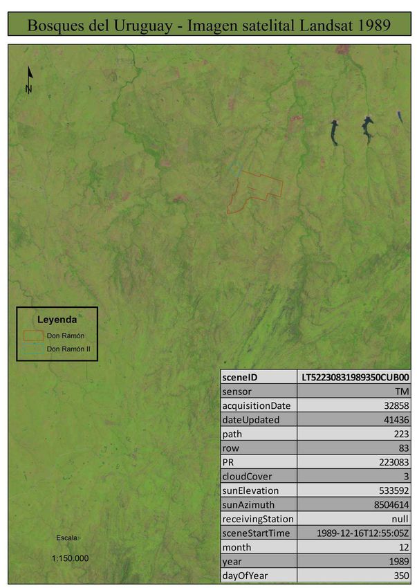
PROJECT DESCRIPTION: VCS Version 3
a) Biological diversity: species with different growth curves and hence different susceptibility to disease,
pests, frost risk, etc.

b) Commercial diversification: timber sales and margin are generated in similar proportions from the two
main products: quality timber and pulp or energy biomass.

c) Productive diversification: some species grow better than others in certain areas of the project lands.
The project will consider the site-specific advantages so carbon can be taken up more efficiently by the
plantations.

Plantation has completed in five years: 2012 - 2016. After harvest of E.dunnii plantations (9 years) a
coppicing management will be practiced to obtain a second rotation. For E. grandis only one rotation (18
years) will be carried out.

Planted trees will uptake carbon dioxide from the atmosphere and store it in different carbon pools
(living above-ground and below-ground biomass, soil organic carbon, litter and dead wood). All these
carbon pools will be accounted towards issuance of VCUs. However, due to methodology provisions,
only above ground biomass will be monitored. Litter and dead wood might be estimated by the use of
conservative defaults factors suggested in the methodological tool.

Besides capturing and storing carbon, other purposes of the project are:

   i.       To produce high quality logs for sawmill industry as priority product and secondarily, biomass for
            energy and/or pulp industry purposes.

  ii.       To promote a management scheme integrated with the local ecosystem and environment.

  iii.      To conduct operations in a social and economically responsible fashion, strictly following labour
            and business local regulations.

The table below summarizes the main technical characteristics of the project:

                    Parameter                                                         Value
                   BDU Trust Fund total area                                        9,528 ha
                   VCS Project area (planted area)                                  3,017 ha
                   % of VCS planted t area within BDU Trust Fund total area           32 %
                   % of area planted with E.grandis (66%)                           1,996 ha
                   % of area planted with E.dunnii (34%)                            1,021 ha

                   Rotation period                                    E.grandis      18 years
                                                                      E. dunnii      9 years

                   Annual growth (IMA)                                E.grandis 24 m3/ha/year
                                                                      E. dunnii 22 m3/ha/year

         a. Site preparation and plantation

Plantation site is prepared by ploughing the soil on strips where the trees will be planted. This will be
done in a certain manner that reduces the risk of erosion and degradation. The objective of ploughing is
to favour the establishment and initial development of plants by increasing the aeration, infiltration and
nutrient availability of the soil, and controlling weeds. Soil disturbance is limited to the width of the strips
and is carried out only once throughout the rotation cycle.

v3.3                                                                                                               8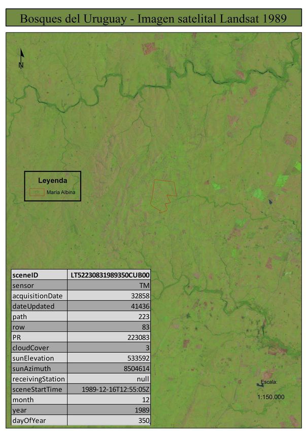
PROJECT DESCRIPTION: VCS Version 3
Weed control is performed by using glyphosate, an environmentally friendly herbicide. Two applications
are carried out some days before tillage and/or plantation. In addition, grazing is used as an effective
method to control the vegetation before planting. Depending on the site conditions, a third post-planting
application might be done. Burning is not practiced as a weed control technique.

Planting is performed mainly manually during spring or fall. In one farm (El Cerco) will be done
mechanically. The planting densities are 1,333 and 1,000 trees per hectare for E. dunnii and E. grandis
respectively.

Seedlings are bought from nurseries renowned for their quality. Seed sources for the production of these
seedlings are selected based on assessments made by institutions or companies in Uruguay, which
ensure good performance in the region. Evaluation criteria to select the genetic origin takes into account
desirable features for solid wood production (e.g. trunk straightness, production, health, density).

On the first year after plantation, during the month February and March, ant control is systematically
performed over the whole area using chlorine-free insecticides with reduced permanence in the
ecosystem. Afterwards insecticides are selectively applied on ant paths and nests. Regarding fertilization,
this is mechanically applied on plantation strips before plantations (phosphorite) and manually applied
around each tree after plantation (NPK).

Plants establishment, survival control, reposition and quality is monitored within the first few weeks after
planting, checks are performed to identify and replace lost plants

       b. Pruning and Thinning

High quality timber plantations, that is the case of E. grandis for this project, require a more intensive
silviculture than those for the production of wood for energy or pulp (E. dunnii in this case), being
necessary several treatments such as pruning and thinning along the rotation. These treatments allow
logs to reach greater diameter and quality increasing their market value.

Pruning and thinning interventions are not carried out for E. dunnii, ending with a final density of around
1,200 trees in year 9.

For E. grandis pruning interventions are carried out at the following heights, ages and number of trees per
hectare:

                                    Pruning     Height    Age    Trees/ha
                                    First       2,5 m      2        All
                                    Second      4,0 m      3       475
                                    Third       6,5 m      4       475
                                    Fourth      9,0 m      5       200

Also for this species three thinning interventions are performed. The first one, carried out at year 2,
removes half of the stocked volume but it does not generate revenues (waste thinning). Its goal is to
eliminate the competence and remove the bad shaped and weak individuals. In the second thinning, at
year 9, all harvested trees goes for pulp industry leaving a total of 250 individuals per ha. Finally, in the
third thinning (year 14) about a third becomes saw timber and two thirds pulpwood. This last thinning
leaves a final density of 150 trees/ha of the highest quality.

Cattle grazing will be carried out all over the project area before plantation takes place and after
plantations have reached 2 years of age so the individuals are not damaged. Within the unplanted areas
cattle will continue grazing. Grazing agreements with external cattle producers will be signed throughout
the project life.

v3.3                                                                                                            9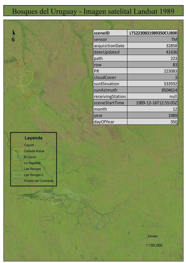
PROJECT DESCRIPTION: VCS Version 3
         c. Final Harvest

Final felling is at year 9 in the case of E. dunnii and year 18 for the E. grandis. In both cases, pre-harvest
inventory is conducted. In E. dunnii sprouts are managed after harvest for the second rotation cycle. At
this stage sprouts from previous thinning are controlled in E. grandis.

         d. Production Standards

The project is managed by AF according to ISO 9001, following its work procedures and manuals. AF is
certified ISO 9001:2008 since 02/12/2014.

The project has also obtained the Forest Stewardship Council (FSC) certification in March 2016.7

The management objective is to carry out an efficient organization with trained and stimulated staff, in
compliance with legal requirements, controlling the impacts of undesirable situations, and good
relationships with customers and the community. The following documents will complement the process
standards: Forest Management Plan (operational and environmental), field manuals, Annual operating
budget and workplace safety standards.

1.9        Project Location

BDU Trust fund total area covers a total of 9,528 hectares of lands located in Central East region of
Uruguay distributed in 14 plots along the departments (counties) of Florida, Durazno, Cerro Largo and
Treinta y Tres. As mentioned above, the BDU project is a fraction of BDU trust fund total area that
comprises 10 entire plots and a part of the 11th one of the 14 plots. . This is clearly seen in the table below
wherein the names, areas and unique geographical locations of the plots are detailed:

                                                    Geographic location       Total Area     Total effectively
                                                    (Center of each land)      of BDU      planted area within
Plot
             Plot Name          Department                                      Trust       BDU VCS project
No.                                                 Latitute      Longitude
                                                                              Fund (ha)       boundary (ha)
    1        Don Ramón          Cerro Largo       32°36’35’’S     54°25’80’’W    812               468
    2         Arévalo           Cerro Largo       32°34’15’’S     55º04’49’’W    703              490
    3       María Albina       Treinta y Tres     33º25’14’’S     54º40’51’’W    582              391
    4       Las Rengas1           Durazno         33º02’00’’S     55º12’41’’W    360              272
    5       Las Rengas 2         Durazno          33º00’25’’S     55º12’21’’W    194              125
    6         Sequeira         Treinta y Tres     33º06’20’’S     54º20’02’’W    241              171
    7      Cañada Brava         Cerro Largo       32º49’31’’S     55º16’03’’W    436              223
    8         El Cerco            Durazno         33º04’25’’S     55º11’19’’W    203              126
             Puntas del
    9                             Durazno         33º02’18’’S     55º07’42’’W    669              447
             Cordobés
    10      La Yeguada         Treinta y Tres     32º58’43’’S     54º59’44’’W    114               85
    11      Mi Generala            Florida         33°47'49''S    55°29'21"W    2.319             217
    12         Caputti          Cerro Largo        32°49'62"S     55°16'37''W    513                -
    13        Reboledo             Florida        33º58’02’’S     55°29’38’’W    813                -
    14       Don Chico             Florida        33º26’13’’S     55º22’10’’W   1.567               -
                                                                  TOTAL (ha)    9,528            3,017

7
    ISO 9001 and FSC certificates available for the VVB at validation.

v3.3                                                                                                        10
PROJECT DESCRIPTION: VCS Version 3
The map below illustrates the lands location within Uruguay8:
Note: Caputti, Don Chico and Reboledo are not within the VCS Project boundary.
8
KML files with the coordinates of each land are provided to the validation entity.
v3.3 11PROJECT DESCRIPTION: VCS Version 3 1.10 Conditions Prior to Project Initiation The traditional activity in the region is the extensive livestock production carried out in medium and large size estates. This production is mainly based on natural pastures, with virtually no improvement areas, implanted pastures or crops. Most of the soils in the area are not suitable for agriculture with some specific exceptions. The project is located in a topography characterized by rolling hills with less than 300 m altitude, abundant water streams and sandy grasslands. The soils that cover 99.2% of BDU project’ effectively planted area are classified as Coneat (Uruguayan classification, composed mainly by different types of litosols, brunosols, regosols, luvisols, inceptisols, argisols and acrisols)9 Groups 2 (2,410 ha) and 8 (584 ha). The soil groups Coneat 2 show emerging rocks of variable density, with slopes ranging from 5-10% to 20-30 %. Coneat 8 present sandy soils of low fertility, developed on sedimentary rocks. Only 0.8% (24 ha) of the BDU project area have recently reclassified by the Ministry of Livestock, Agriculture and Fisheries (MGAP) of Uruguay as Coneat Group G03.11 and G03.21. These soils groups are flooded and soaked, respectively.10 Annual precipitation in the project area ranges from 1,100 to 1,300 mm, homogeneously distributed along the year, although periods of severe drought and severe water excess are rather frequent. Mean annual temperature is 18 ºC, varying from 12 ºC (July) to 25 ºC (January). Night frosts occur during the winter (from mid-May to early October), with an average of 30 days with frost per year, with temperatures seldom falling below –5 ºC. Soils depths are reduced, of medium-to-coarse texture, with low natural fertility and high limitations for agricultural production. Dominant land cover in the area is grassland, with predominance of herbaceous vegetation (mainly grass species) with scattered and scarce shrubs. The vegetation is highly determined by land use (grazing of cattle and sheep). Native grass and other herbaceous species were abundant before cattle were introduced in the XVII Century, and then land was richer in shrubs and small trees. Native trees appear naturally only at the side of rivers and streams, covering only 3 to 5 per cent of the land area. This has been attributed to the natural occurrence of frequent droughts which prevented slow growing trees from becoming established against an aggressive competition by grasses. The project area consists basically of grassland altered by many years of grazing. This would have caused a significant change in species, as well as some soil loss due to laminar erosion due to frequent over grazing. Due to the change in the regime of precipitation observed in recent years, with an increasing trend in both total precipitation and storm intensity, combined with the effects of overgrazing, particularly in dry periods, the soils in the project area would be subjected to increasing erosion and degradation pressures. This pasture land covers virtually all the project area. Associated with this, there are lowlands and wetlands, with richer biodiversity and higher conservation value. The forests within the project boundaries will be planted on grazing areas, and it was designed with the objective of preserving the most valuable areas outside project boundaries. These conservation areas include natural forests alongside the rivers and minor water streams, composed by hydrophilic species close to the streams, and xerophytic species of shrubs and tall grasses surrounding them in a transition to the grasslands. 9 The Coneat index has been structured by the Ministry of Livestock, Agriculture and Fisheries (MGAP) and the National Commission of Agro-economic Study of the Soil (CO.N.E.A.T); http://www.renare.gub.uy (Route of access: Soil and water/CONEAT/Grupos CONEAT) 10 CO.N.E.A.T. groups o soils description. https://www.mgap.gub.uy/sites/default/files/descripcion_de_grupos_de_suelos_coneat.pdf v3.3 12
PROJECT DESCRIPTION: VCS Version 3
1.11 Compliance with Laws, Statutes and Other Regulatory Frameworks

The activities proposed by the Project comply with national law and regulations, since forest investment
has been approved by the General Forestry Directorate (entity of the Ministry of Agriculture, Livestock
and Fishery) and the National Environment Directorate (entity of the Ministry of Housing, Territorial
Planning and the Environment). The former ensures that the project activity follows practical and
reasonable silvicutural practices, while the second granted the environmental authorization.

Furthermore, the project will pursue FCS certification ensuring that it complies with all legal,
environmental, social and labor regulations.

1.12 Ownership and Other Programs

1.12.1 Project ownership

Ownership certificates and titles stating that the land units within project boundaries are owned by the
Trust Fund are kept by the Trustee on behalf of the Trust Fund. Also, a special power of attorney granted
by the Trustee EFAM to the Administrator AF to act in the name of EFAM to carry on all operational and
commercial activities related to the project. They are provided to the validation team.

1.12.2 Emissions Trading Programs and Other Binding Limits

GHG removals generated by the project will not be used for compliance with binding limits to GHG
emissions since Uruguay does not have GHG emission compliance nor trading programs in place.

1.12.3 Other Forms of Environmental Credit

BDU Project is a new afforestation project and is not registered in any other GHG program.

1.12.4 Participation under Other GHG Programs

The project will only generate credits from the storage of carbon in forest pools, and these are claimed
only under the VCS program.

1.12.5 Projects Rejected by Other GHG Programs

BDU Project is a new forestry project and has not been rejected by any other GHG program.

1.13 Additional Information Relevant to the Project

        Eligibility Criteria

BDU Project is a single project.

        Leakage Management

According to the applicable methodology only leakage due to the displacement of agricultural activities
shall be considered. As explained in section 3.3 below, the project does not displace pre-project
agricultural activities. Thus, neither a leakage management plan nor leakage mitigation measures are
required.

v3.3                                                                                                       13
PROJECT DESCRIPTION: VCS Version 3
Commercially Sensitive Information
No commercially sensitive information has been excluded from the public version of the project
description.
Sustainable Development
Uruguay is among the 150 countries that adopted the 2030 Agenda for Sustainable Development,
including the Sustainable Development Goals (SDGs) at the United Nations Sustainable Development
Summit on 25 September 2015.
The National Government’ Office of Planning and Budget (OPP), the National Statistics Institute (INE)
and the Uruguayan International Cooperation Agency (AUCI) are coordinating efforts at government level
to establish and implement monitoring systems for ODS indicators integrated with the national planning
and identifying the advances and challenges in relation to them.11. 12, 13, 14
The 17 SDGs aim to end poverty, hunger and inequality, take action on climate change and the
environment, improve access to health and education, build strong institutions and partnerships, and
more.
In this regard, BDU project contributes to the achievement of the country’s goals defined to reach the
SDGs by:
• Increasing labour demand from the local population: the common activity developed in the project
region is cattle breeding. Besides the forestry plantation activities, the project will maintain the cattle
rising both on the unplanted area and under its plantations from year 2 to the end (many local
researchers support cattle breading inside forests as animals suffer less temperature stress and for
storms protection). This will generate a much larger demand of labour when compared to these
activities being developed separately.
• Adding value to wood products and diversifying the regional production will lead to higher economic
revenues for the region.
• Promoting an integrated management scheme with the ecosystem. In this sense, it already obtained
the necessary approval from the DINAMA (National Directorate of Environment)15 and the plantations
are certified under the FSC standard.
• Creating and developing a new mechanism to finance projects in the forestry sector.
• Generating net anthropogenic CO2 removals by sinks.
BDU is a VCS certified project16 and thus, social, economic and environmental impacts are monitored.
Please, refer to section 5.1 below for further information about BDU monitoring system17, 18.
11
http://deres.org.uy/los-objetivos-de-desarrollo-sostenible/
12
http://www.opp.gub.uy/decimos/noticias/item/1663-claves-y-desafios-de-uruguay-para-una-agenda-2030-en-
los-objetivos-de-desarrollo-sostenible
13
http://www.opp.gub.uy/decimos/noticias/item/1659-proceso-de-consulta-para-el-monitoreo-y-seguimiento-de-
los-ods
14
https://www.presidencia.gub.uy/comunicacion/comunicacionnoticias/opp-seminario-un-pacto-global-red-
uruguay-seminario-los-%20objetivos-desarrollo-sostenible
15
By the time of submission of this PD version to the validating entity (17/04/2017) only one cadastral unit of a
plot, that corresponds to an extension, is waiting for DINAMA Resolution. Refer to section 5.
16
VCS certification report and certificate available for the VVB.
v3.3 14PROJECT DESCRIPTION: VCS Version 3
The generation of net anthropogenic CO2 removals by sinks will be monitored as part of the present VCS
project.
Further Information
There are two aspects of BDU Project that are important to highlight:
1. About BDU Forestry Financial Trust
BDU Trust objective is to structure a long-term investment alternative supported by a tangible asset that
increases its value throughout time and by a strong management plan. Following the highest productive,
environmental and social standards, and aiming to attain a production of high quality timber, the trust will
offer pension fund investors reasonable long term profits.
The novelty of this trust lies in the fact of being the first one in the history of the country presenting a
public offer at Montevideo stock exchange and the first one that convinces a pension fund (called AFAP
in Uruguay) to invest in this type of project with physical assets and productive risks. In general, these
funds invest in low risk government bonds which offer similar rates of return but at a much lower risk.
Among the values promoted by the trust are: excellence in the performance, accountability and ethics. In
order to convince the pension funds to invest money in the trust many aspect of BDU project were
highlighted, being climate change mitigation, sustainability and carbon credits incomes the most relevant
ones. The endeavor was not easy though. In fact, in the last days previous to the certificated issuance
the whole process was close to fail given the negative pressure from some of the AFAPs, who were
reluctant to commit before the IPO.
In order to become operative, the Trust had to obtain the approval of its business plan from the president
of the country and the Central Bank of Uruguay. This whole bureaucratic procedure took a long time, over
18 months.
2. Productive and socio-economic characteristics of the project’s region
The center east region of Uruguay, where BDU project will be installed, is a traditional rural area
characterized by a limited development level in terms of infrastructure, industry and socio-economic
conditions. Population in the region relies mainly on the incomes coming from a low labor demanding
production: the extensive livestock. BDU Project will contribute with the regional development by creating
qualified jobs that could potentially lead to setup forest industries in the area and eventually demand more
infrastructure.
Forestry activity in Uruguay is principally carried out in other regions of the country (North, West and
South). The lack of infrastructure, services, qualified workforce and local forest industries limited the
establishment of forests in this region.
Commercial plantations at large scale did not make progress in Uruguay until the beginning of the 90’. By
that time the planted area was around 50 thousand hectares. Most of this area consisted in short-rotation
eucalypts (10 years) and pines (25 years), planted with very precarious technology based on poor genetic
materials and silvicultural practices. Growth rates were relatively low, and pulp logs, low-grade timber and
firewood were the main products. This situation started to change dramatically in 1987 when Law No.
15,939 was passed containing instruments of forestry promotion. The main objectives of this policy were
17
BDU Forestry management plan public summary, which includes the monitoring system, available at:
http://www.bosquesdeluruguay.com/documentos.php?p=bdu-1-plan-de-manejo-forestal
18
2016 Monitoring public summary available at: http://www.bosquesdeluruguay.com/download/RESUMEN-
PUBLICO-MONITOREOS-2016-BDU.pdf
v3.3 15PROJECT DESCRIPTION: VCS Version 3
to create a new source of exports and a sustainable supply of firewood while protecting natural forests.
This policy was highly successful, and resulted in a notable growth of forested area. In this sense,
plantation rate grew almost exponentially to reach in 2008 an area larger than 800 thousand hectares as
seen in the graphic below.
Evolution of total forested area in Uruguay, 1975 – 2008 (Source: General Directorate of
Forestry; Ministry of Livestock, Agriculture and Fishing)19
However, most of these new plantations are concentrated in other departments than those where BDU
project is developed: Florida, Treinta y Tres, Cerro Largo and Durazno. As the table below shows, this
region concentrates less than 20% of the total planted area while it represents more than 25% of the
country land area.
Total % of Total
Department Planted Planted
area20 area
Rivera 164.522 16,6%
Paysandú 131.071 13,2%
Río Negro 122.464 12,4%
Tacuarembó 111.087 11,2%
Lavalleja 110.824 11,2%
Durazno 62.000 6,3%
Cerro largo 59.515 6,0%
Florida 51.335 5,2%
Rocha 43.162 4,4%
Maldonado 36.888 3,7%
Soriano 36.214 3,7%
Treinta y Tres 24.281 2,5%
Canelones 18.734 1,9%
19
BDU Trust Fund Prospect; 15/06/2011; Page 21. Available at:
http://www.bosquesdeluruguay.com/documentos.php
20
Source: DGF-MGAP; Total Forest Area/Registered planted forests/All species. Available at:
http://www.mgap.gub.uy/portal/hgxpp001.aspx?7,20,441,O,S,0,MNU;E;134;2;MNU. The percentage refers to
effective area (includes plantation area plus roads and firebreak areas).
v3.3 16PROJECT DESCRIPTION: VCS Version 3
San José 7.780 0,8%
Flores 4.271 0,4%
Colonia 3.217 0,3%
Montevideo 1.352 0,1%
Salto 838 0,1%
Artigas 475 0,0%
Total Planted Area 990.030 100%
Total Planted Area in
197.131 19,9%
Project’s Departments
Even though the area of planted forest grew very fast during the last decade, forest industry in Uruguay
did not follow the same trend. There are only three pulp mills in the country of which only one has a
considerable size. The largest pulp mill currently operating is UPM, established in 2007 (Río Negro), has
a capacity to produce 1.1 million tons of cellulose per year. In addition, there are two small pulp mills
(120,000 t/year) located in the Southwest part of Uruguay. Montes del Plata is building a 1.5 million t/year
cellulose plant in Colonia but would be commissioned by the end of 2014. In recent years, two new
plywood plants have been established in Tacuarembó (Weyerhaeuser Productos and Urupanel), with a
combined processing capacity of 600,000 m3/year. In relation to chipping plants, there are four in
operation, processing 2.1 million m3/year of round wood, located also in the southwest of Uruguay 21.
There is a larger number of sawmills (estimated in 200) however the vast majority of them are highly
small, very inefficient units, which do not have a significant aggregated demand for wood. The only large
ones are Urufor (Rivera), FYMNSA (Rivera) and Caja Bancaria (Rio Negro). The smaller sawmills are
mainly concentrated in Paysandú and Montevideo and their surrounding areas.
There are a few wood preservation plants scattered throughout the country, all of them small.
As it can be observed most of these industries are located in the North, West and South regions, where
most plantations were established and away from the project site. For the Central East region, the facts
of being away from the forest industries and from the export ports are main reasons to explain the limited
development of forestry plantations in the area. Grassland under extensive grazing continued to be the
dominant land use within this region.
Model used to estimate biomass accumulation
A model created by the National Agricultural Research Institute (INIA) in March 2003 was used. Its name
is SAG Grandis and is the only growth simulation model available in Uruguay specific for the species
planted in this project. In August 2008, it included a module to model E. dunnii, intended for pulp
plantation management. The SAG Grandis model is widely used in private forestry companies in the
country. It considers many variables as inputs such as initial age, dominant average height, basal area or
mean diameter and geographical zones. This is an empirical model, i.e. data that was set with actual
growth sampling plots.22
21 “Forestry characterization in Uruguay; 2011, Rosario Pou & Asociados. Available at:
http://www.uruguayforestal.com/informes/Forestacion%20en%20Uruguay-2011.pdf
22
SAG Grandis: Support system for the Eucaliptus Grandis Plantation Management; 2003; Ricardo Methol; INIA.
Available at: http://www.inia.uy/Publicaciones/Documentos%20compartidos/15630021107224844.pdf
v3.3 17PROJECT DESCRIPTION: VCS Version 3
2 APPLICATION OF METHODOLOGY
2.1 Title and Reference of Methodology
The following methodology and tools referenced in it are applicable to the present project activity:
• “AR-ACM0003: Afforestation and reforestation of lands except wetlands”, Version 02.0
• “Combined tool to identify the baseline scenario and demonstrate additionality in A/R CDM
project activities”, Version 01
• “Estimation of carbon stocks and change in carbon stocks in dead wood and litter in A/R CDM
project activities”, Version 03.1
• “Estimation of carbon stocks and change in carbon stocks of trees and shrubs in A/R CDM
project activities”, Version 04.2
• “Tool for estimation of change in soil organic carbon stocks due to the implementation of A/R
CDM project activities”, Version 01.1.0
• “Estimation of the increase in GHG emissions attributable to displacement of pre-project
agricultural activities in A/R CDM project activity”, Version 2.0
• ”Calculation of the number of sample plots for measurements within A/R CDM project activities”;
Version 2.1.0
Note: the tool “Estimation of non-CO2 GHG emissions resulting from burning of biomass attributable to an
A/R CDM project activity” is not applicable to the present project activity since biomass burning practices
will not be part of the project activity.
2.2 Applicability of Methodology
As established in the methodology, it is applicable under the following conditions:
(a) The land subject to the project activity does not fall in wetland category;
(b) Soil disturbance attributable to the project activity does not cover more than 10 per cent of area in
each of the following types of land, when these lands are included within the project boundary:
i. Land containing organic soils;
ii. Land which, in the baseline, is subjected to land-use and management practices and receives
inputs listed in appendices 1 (Cropland in which soil disturbance is restricted) and 2 (Grassland in
which soil disturbance is restricted) to this methodology.
Wetland
The land does not fall into wetland category. There are no wetlands in the project area.
Soil Disturbance
The disturbance to the soil attributable to the project activity covers plough strips of 0,8 m width every 4 m
to the effectively planted area, representing 7% of the total BDU Trust Fund project area and 20% of the
BDU VCS project boundary area. Having said this, the soil types of the project cannot be categorized as
(i) organic or (ii) grassland in which soil disturbance is restricted. According to 2006 IPCC Guidelines
(Annex 3A.5, Chapter 3, Volume 4), organic soils must have at least 12 percent organic carbon by weight
(i.e., about 20 percent organic matter). As it is described by Silva23 organic matter content in brunosoles
soils (from Coneat 2) range from 3.1 to 8.2%, and in Luvisoles soils (from Coneat 8) going from 1.5 to
2.7%. In none of these soil types the organic matter content, and hence the organic carbon, reaches the
20% of the organic soils. Given that, as above stated BDU project soils are classified as Coneat 2 and 8,
it is concluded that the soil types of the project are not organic.
23LA MATERIA ORGANICA DEL SUELO, Ing. Agr. Alfredo Silva,
www.edafologia.fcien.edu.uy/archivos/Clase%203%20MOS.ppt
v3.3 18PROJECT DESCRIPTION: VCS Version 3
BDU project lands are characterized by pastoral activity with regular usage capacity and without
technological improvements, implanted pastures or crops. These natural grasslands do not receive
intensive management with added agricultural inputs such as fertilization, reseeding, etc. The soils are of
reduced natural fertility and current erosion is relatively low. Hence, the Project is applicable to this
methodology.
A project activity applying this methodology shall also comply with the applicability conditions of the tools
contained within the methodology and applied by the project activity.
CDM project standard
This standard establishes a set of specific requirements for afforestation and reforestation project
activities, among which stands out the eligibility of the land.
In order to demonstrate the land eligibility, the PP should follow the “Procedures to Demonstrate the
Eligibility of Lands for Afforestation and Reforestation CDM Project Activities” in which Project participants
shall provide evidence that the land within the planned project boundary does not contain forest and that
the activity is a reforestation or afforestation project activity
The land eligibility is demonstrated though the use of satellite imagery showing that vegetation on the
land has been below the forest threshold according to the definition of forest adopted by Uruguay. In this
regard, the table below provides the details of the adopted definition24:
A single minimum tree crown A single minimum land area A single minimum tree height
cover value between 10 and 30 value between 0,05 and 1 value between 2 and 5 metres
per cent hectare
30 0,25 3
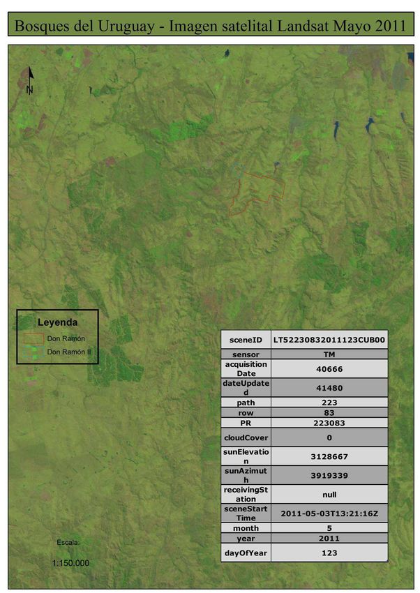
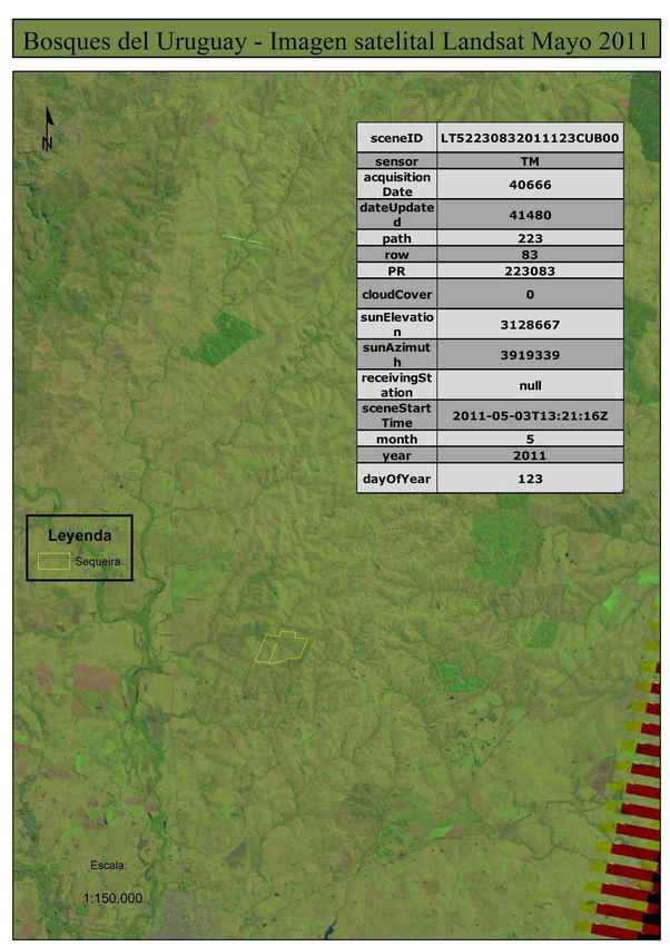
The satellite images displayed below show that the land did not contain forest on 31 December 1989 nor
at the moment the project started in May 2012. As it can be seen the images obtained correspond to May
2011, a year before the project start but by the time the land was being acquired. The land was covered
by natural pastures and some scattered trees planted for cattle shade not qualifying as forest.
24
http://cdm.unfccc.int/DNA/index.html
v3.3 19PROJECT DESCRIPTION: VCS Version 3
Note: Caputti is not within the VCS Project boundary.
v3.3 20PROJECT DESCRIPTION: VCS Version 3
Note: Caputti is not within the VCS Project boundary.
v3.3 21PROJECT DESCRIPTION: VCS Version 3 v3.3 22
PROJECT DESCRIPTION: VCS Version 3

v3.3                                   23
PROJECT DESCRIPTION: VCS Version 3

v3.3                                   24
PROJECT DESCRIPTION: VCS Version 3

v3.3                                   25
PROJECT DESCRIPTION: VCS Version 3

v3.3                                   26
PROJECT DESCRIPTION: VCS Version 3

v3.3                                   27
PROJECT DESCRIPTION: VCS Version 3

       Note: Reboledo and 80% of Mi Generala’ total area are not within the VCS Project boundary.

v3.3                                                                                                28
PROJECT DESCRIPTION: VCS Version 3
Note: Reboledo and 80% of Mi Generala’ total area are not within the VCS Project boundary.
Note: Don Chico is not within the VCS Project boundary.
v3.3 29PROJECT DESCRIPTION: VCS Version 3 v3.3 30
PROJECT DESCRIPTION: VCS Version 3

v3.3                                   31
PROJECT DESCRIPTION: VCS Version 3
Regarding VCS eligibility requirements (AFOLU requirements, version 3.4, section 3.1.6), grassland
vegetation dominating before project start is not the native ecosystem of the land within project
boundaries. The native condition was modified by the introduction of beef cattle and sheep in the 17th and
19th centuries, respectively, and by the introduction of exotic species during the last three centuries.

Additionality Tool
The “Combined tool to identify the baseline scenario and demonstrate additionality in A/R CDM project
activities” is applicable under the following conditions:
- Forestation of the land within the proposed project boundary performed with or without being
   registered as the A/R CDM project activity shall not lead to violation of any applicable law even if the
   law is not enforced.
- This tool is not applicable to small - scale afforestation and reforestation project activities.

These conditions are met by the proposed project activity. The project has received all required approvals
from the necessary local authorities to start the implementation and the project is considered a large-
scale afforestation.

Carbon stock of trees, shrubs, dead wood and litter
Tools “Estimation of carbon stocks and change in carbon stocks of trees and shrubs in A/R CDM project
activities” and “Estimation of carbon stocks and change in carbon stocks in dead wood and litter in A/R
CDM project activities” do not establish applicability conditions.

Soil Organic Carbon Stock
The “Tool for estimation of change in soil organic carbon stocks due to the implementation of A/R CDM
project activities” is applicable when the baseline scenario and the project activity areas of land do not fall
into wetland category; contain organic soils are not grassland in which soil disturbance is restricted. Also,
when the proposed project activity meets the following conditions: Litter remains on site and is not
removed and soil disturbance, if any, is in accordance with appropriate soil conservation practices.

Both the land features and the conservation practices applicability requirements are met by the project
making this tool applicable to it. The case of the land was previously discussed in this section.
In relation to the conservation practices (litter removal and soil disturbance) the project has obtained the
FSC certification in March 2016 implying that these conditions will are accomplished25. It is important to
mention that the land will be disturbed only once in the project lifetime in both cases. E. grandis has only
one rotation (18 years) and dunnii has two (9 years/each) but the second one will be managed trough a
coppicing scheme without soil disturbances.

Emissions from Biomass Burning
The tool “Estimation of non-CO2 greenhouse gas (GHG) emissions resulting from burning of biomass
attributable to an A/R CDM project activity” is applicable to all occurrence of fire within the project
boundary and it mandates to calculate Non-CO2 GHG emissions provided that the accumulated area
affected by such fires in a given year is ≥5% of the project area.
As above mentioned, it is not applicable to the present project activity since biomass burning practices
will not be part of it.

Displacement of Agricultural Activities
The tool “Estimation of the increase in GHG emissions attributable to displacement of pre-project
agricultural activities in A/R CDM project activity”. is applicable to the present project activity since the
displacement of agricultural activities is not expected to cause, directly or indirectly, any drainage of
wetlands or peat lands, as requested in the applicability condition of the tool.

In conclusion, the project activity complies with all applicability conditions of the selected methodology.

25
     FSC certificate available for the VVB at validation.

v3.3                                                                                                            32
PROJECT DESCRIPTION: VCS Version 3
2.3 Project Boundary
The following table describes the carbon pools selected for accounting of carbon stock changes.
Carbon Pools Gas Included? Justification/Explanation
CO2 No As described above the project area is composed
basically by degraded pastures with no tree or
shrub biomass on it. Besides, the project area
Above-
excludes existing tree biomass from the baseline.
ground
Thus, above-ground biomass is negligible as per
biomass
the CDM tool “Estimation of carbon stocks and
change in carbon stocks of trees and shrubs in A/R
CDM project activities”.
Baseline
Below- CO2 No
ground Same rationale as with above-ground biomass
biomass
Dead- CO2 No
Assumed to be nil for the life of the project.
wood
Litter CO2 No Assumed to be nil for the life of the project.
CO2 No Soil organic carbon stocks are expected to remain
Soil
at a steady state or decrease in the baseline
organic
scenario. Assumed to be nil for the life of the
carbon
project.
Above- CO2 Yes
ground Required. Largest pool affected by project activity.
biomass
Below- CO2 Yes
Required. Expected to increase due to project
ground
activity.
biomass
CO2 Yes Optional. Expected to increase due to project
Dead-
activity, since it does not virtually exist in the pre-
wood
project situation.
Project
CO2 Yes Optional. Expected to increase due to project
Litter activity, since it does not virtually exist in the pre-
project situation.
CO2 Yes Optional. Expected to increase due to project
activity. Even though there may be a transient
reduction in soil organic carbon due to site
Soil
preparation (e.g., tillage), the establishment of
organic
forest is expected to cause an increase in net
carbon
primary productivity and, therefore, in the turnover
of plant residues into the soil. This would lead to a
long-term increase in the soil organic carbon pool.
The table below shows the emission sources and associated GHGs selected for accounting:
v3.3 33You can also read


