Clifden Local Area Plan 2018-2024 - December 2018 - Galway County Council
←
→
Page content transcription
If your browser does not render page correctly, please read the page content below
Clifden Local Area
 Plan 2018-2024
    December 2018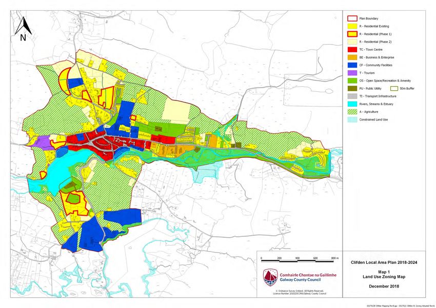
2
Table of Contents
1.0 Introduction………………………………………………………………………………….. 3
1.1 Preamble ...................................................................................................................... 3
1.2 Profile of Clifden............................................................................................................ 3
1.3 Local Area Plan............................................................................................................. 4
1.4 Plan Informants & Key Considerations .......................................................................... 6
2.0 Strategic Vision and Development Strategy .............................................................. 9
2.1 Strategic Vision ............................................................................................................. 9
2.2 Development Strategy................................................................................................. 14
3.0 Development Policies, Objectives and Guidelines ................................................. 14
3.1 Land Use Management ............................................................................................... 16
3.2 Residential Development ............................................................................................ 24
3.3 Social and Community Development .......................................................................... 28
3.4 Economic Development .............................................................................................. 31
3.5 Transportation Infrastructure ....................................................................................... 35
3.6 Utilities Infrastructure, Climate Change & Flood Risk Management............................. 40
3.7 Urban Design and Landscape ..................................................................................... 52
3.8 Built Heritage & Cultural Heritage ............................................................................... 55
3.9 Natural Heritage & Biodiversity ................................................................................... 60
4.0 Appendices ............................................................................................................... 65
4.1 Appendix 1 - Opportunity Sites ................................................................................................ 65
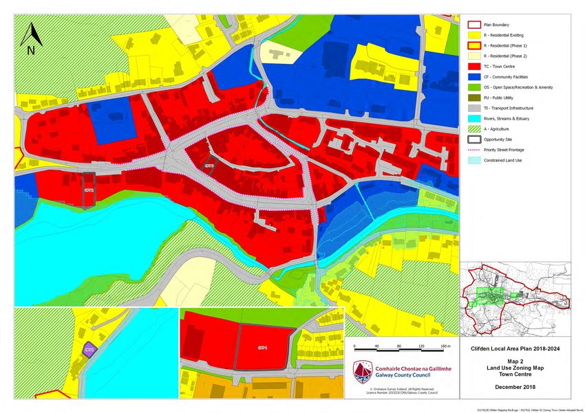
4.2 Appendix 2 - Maps ..................................................................................................................... 69
Map 1- Land Use Zoning
Map 2- Land Use Zoning Town Centre
Map 3– Flood Risk Management
2
3

1.    Introduction
1.1 Preamble
This Local Area Plan is a land use plan and overall strategy for the development of Clifden covering the period 2018
– 2024. This plan shall have effect from the date of adoption by the elected members of Galway County Council and
shall cease to have effect at the expiration of 6 years from that date, unless the plan period is extended by resolution
in accordance with Section 19 (d) to (f) of the Planning and Development Act 2000 (As amended). The successful
implementation of the plan should have a positive impact on Clifden, ensuring it develops in a sustainable manner
and complements the implementation of the current Galway County Development Plan 2015-2021.

1.2 Profile of Clifden
Clifden is located in the western coastal area of Connemara in County Galway, approximately 80 kilometres north-
west of Galway City. The coastal village of Cleggan is located approximately 10km north of Clifden town, while
Ballyconnelly is 10km to the south, along the coast. The town of Clifden is the main urban settlement serving the
Connemara area as well a considerable rural hinterland in the west of the county. Apart from Galway City, the
nearest large urban settlement is Westport in County Mayo, which is located 80km to the north-east. Clifden is
served by the National Secondary Road, the N59 which is the main Galway-Clifden-Westport route, serving
Connemara.

       Figure 1. Contextual location of Clifden

Clifden, “An Clochan” in Irish, is a planned town, founded in the 19th century by John D’Arcy of Kiltullagh, Athenry.
His castle located west of the town centre on the Sky Road. Clifden has a rich history which has moulded the town
both physically and culturally. In particular, its associations with Marconi and Alcock & Brown during the 19th
Century; the Galway-Clifden railway; and its function as a Maritime Port. Its historical importance as a settlement is
demonstrated in monuments such as the Famine Graveyard, Clifden Castle and Clifden Gaol, and Clifden
Courthouse. Today, Clifden is a thriving local market town and tourist centre. It hosts a very successful annual Arts
Festival along with many other vibrant events throughout the year.
The topography and natural features (Alpine) of the area have influenced the pattern and form of development in the
town. Clifden is intersected by the Owenglin River which flows through the town and into the sea at Ardbear bay an

                                                                                                                         3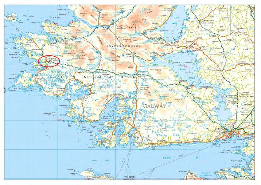
4

inlet of Clifden Bay. Clifden is one of a series of harbours facing the Atlantic, sheltered to the North and South. On
the land side, Clifden lies in the sheltered valley between the Falkeeragh and Shanakeever hill ridge areas to the
North and the Ardbear and Killymongan hill areas to the South.
The Owenglin River which flows into the sea through the town of Clifden contains brown and sea trout as well as
salmon, attracting anglers and tourists. Tourism is a critical economic resource for Clifden and its environs offering
the visitor a microcosm of the West of Ireland with the added advantage of a well-developed tourist service centre.
The continued development of the Connemara Greenway running from Clifden to Galway City will further assist the
tourism draw to the area.
The Galway County Development Plan 2015 – 2021 identifies Clifden as a Key Town in the settlement hierarchy for
the county. This entails it functioning as a self-sufficient service hub, offering a range services including health,
community, finance, employment, educational and retail provision to a broad catchment population. The population
of Clifden has risen very slightly since the last Census. The 2016 Census for Clifden settlement indicates a
population of 1597. Since the 2006 Census, the population of Clifden (1497) has grown by 100 inhabitants
demonstrating a 6% increase. The 2011 census figures were returned on the day of the Clifden 10 KM run and are
therefore not reflective of the ordinary resident population. It is envisaged that the population of Clifden will grow by
approximately 250 people over the lifetime of the County Development Plan 2015-2021, in order for the town’s
development to progress in structured and responsive manner to the needs of the local population requires a
proactive plan that will enable the town to grow and prosper in a sustainable manner.

1.3 Local Area Plan
1.3.1 Background to the Local Area Plan
This Local Area Plan has been prepared by Galway County Council to provide a statutory framework for the future
growth and development of Clifden. It is consistent with the policies and objectives contained in the Galway County
Development Plan, including the Core Strategy, and seeks to address the needs and requirements of the local
community, service providers and other stakeholders. The purpose of the Local Area Plan is to guide future
development within the town in a sustainable and equitable manner and to inform members of the public, the local
community, stakeholders and developers, of the policies and objectives that will shape the development of the town
over the next six years. The policies and objectives for the development of the town include provisions in relation to
land use management, community facilities, amenities, transport, infrastructure, urban design, cultural/built heritage,
natural heritage and the environment.
The plan period is for 6 years, from the date of adoption by Galway County Council, unless the timeframe is
extended by resolution in accordance with Section 19(1)(d) of the Planning and Development (Amendment) Act
2010. The plan area is comprised of the town and its immediate environs and is considered to provide an
appropriate development envelope for the anticipated growth of the town for the plan period.

1.3.2 Statutory Process
A Local Area Plan is prepared under the provisions of Sections 18, 19 & 20 of the Planning & Development Act 2000
as amended. A Local Area Plan is statutorily required to be consistent with the objectives of the current Galway
County Development Plan 2015-2021 and consists of a written statement and plans which may include objectives for
the zoning of land in accordance with the proper planning and sustainable development of the area. The legislation
also requires the provision of detail on community facilities, amenities and detail on standards for the design of
developments and structures.
Environmental assessments have also been undertaken to assess the potential impacts of the Local Area Plan on
the environment, including a Strategic Environmental Assessment (SEA), the output of which is an (SEA)
Environmental Report (SEA-ER) and a Stage 2 Appropriate Assessment (AA), the output of which is an AA Natura
Impact Report (AA NIR). The SEA ER has been prepared in accordance with the EU Directive on SEA (2001/42/
EC), the national SEA Regulations (SI No. 436 of 2004), (SI No. 201 of 2011), the 2004 Strategic Environmental
Assessment Guidelines Implementation of the SEA Directive (2001/42/EC): Assessment of the Effects of Certain
Plans and Programmes on the Environment issued by the Department of Environment, Heritage and Local
Government (DoEHLG) and regard has also being given to Circular PSSP 6/2011 ‘Further Transposition of the EU
Directive 2001/42/EC on Strategic Environmental Assessment (SEA). The SEA is required as part of the plan
making process to assess the likely significant adverse effects on the environment of implementing the Local Area

                                                                                                                            4
5

Plan, before a decision is made to adopt it. The findings of the SEA are provided in SEA ER.
The AA (also referred to as) a Habitats Directive Assessment has been prepared in accordance with Article 6(3) of
the EU Habitats Directive (92/43/EEC), European Communities (Birds and Natural Habitats) Regulations 2011, the
Appropriate Assessment of Plans and Projects in Ireland-Guidance for Planning Authorities 2010 issued by the
Department of Environment, Heritage and Local Government and the Planning and Development Act 2000, (as
amended). An Appropriate Assessment is an assessment of the implications of the plan or project, alone and/or in
combination with other plans and projects, on the integrity of a European Site, in view of its conservation objectives.
A Stage 2 Strategic Flood Risk Assessment (SFRA) has been prepared for County Galway, which broadly considers
the flood risk issues relevant to the plan area. The Strategic Flood Risk Assessment has been prepared in
accordance with the EU Floods Directive (2007/60/EC), the national European Communities (Assessment and
Management of Flood Risks) Regulations 2010 (SI No. 122 of 2010), the Planning System and Flood Risk
Management Guidelines for Planning Authorities 2009 issued by the DoEHLG as updated by the Departmental
Circular PL 2/2014 and identifies indicative flood risk areas within Clifden.
The relevant data, recommendations and mitigation measures from the (SEA, AA & SFRA) have been incorporated
into the Local Area Plan, as appropriate.

1.3.3 Plan Structure
The Local Area Plan has been structured into 4 main sections as outlined below:
    Section 1                Introduction

                              Preamble

                              Profile of Clifden

                              Local Area Plan

                             Plan Informants and Key Considerations.
    Section 2                Strategic Vision and Development Strategy

                              Strategic Vision

                              Development Strategy

    Section 3                Development Policies, Objectives and Guidelines

                              Land Use Management

                              Residential Development

                              Social and Community Development

                              Economic Development

                              Tourism

                              Transportation Infrastructure

                              Utilities, Climate Change and Flood Risk Management

                              Urban Design and Landscape

                              Built Heritage and Cultural Heritage

                              Natural Heritage and Biodiversity

                                                                                                                          5
6

        Section 4               Local Area Plan Maps

                                 Map 1- Land Use Zoning

                                 Map 2- Land Use Zoning– Town Centre

                                 Map 3- Flood Risk Management

Supporting documents include a Stage 2 Appropriate Assessment (AA/NIR), an Environmental Report
(SEA/ER) and a Stage 2 Strategic Flood Risk Assessment (SFRA) for the LAP area, which are available as separate
documents to the Clifden Local Area Plan.

1.4 Plan Informants and Key Considerations
1.4.1 Plan Informants
The preparation of the Clifden Local Area Plan has been informed by a wide range of inputs, including the following:

        Public Consultation        Issues raised by the local community and other stakeholders through
                                   the publication of the draft Plan for public consultation and written
                                   submissions will all be considered.

        Legislative Context        All relevant Irish and European planning and environmental legislation,
                                   in particular the Planning and Development Act 2000 (as amended),
                                   the Planning and Development Regulations 2001 (as amended); EU
                                   Directives, including the Birds Directive (2009/147/EEC), Habitats
                                   Directive (92/43/EEC), Water Framework Directive (2000/60/EC), SEA
                                   Directive (2001/42/EC), Floods Directive (2007/60/EC), EU Directive
                                   2014/52/EU which amends Directive 2011/92/EU on the Assessment
                                   of the Effects of Certain Public and Private Projects on the
                                   Environment (EIA) and all associated regulations.

        Strategic Planning         National Planning Framework Published 16th February 2018, “Ireland
        Context                    2040”, the Regional Planning Guidelines for the West Region 2010-
                                   2022, National Development Plans, the emerging Regional Spatial
                                   and Economic Strategy any subsequent Regional Planning Guidance),
                                   the National Climate Change Strategy 2007-2012 and follow on
                                   document “National Climate Change Adaptation Framework Building
                                   Resilience to Climate Change 2012, Smarter Travel - A Sustainable
                                   Transport Future 2009-2020, and a range of guidelines including the
                                   Local Area Plan Guidelines (2013), SEA Guidelines 2004, Sustainable
                                   Residential Development in Urban Areas Guidelines 2009, Spatial
                                   Planning and National Roads-Guidelines for Planning Authorities
                                   (2012), The Planning System and Flood Risk Management Guidelines
                                   for Planning Authorities 2009 & Departmental Circular PL2/2014,
                                   Implementation of SEA Directive: Assessment of the Effects of Certain
                                   Plans and Programmes on the Environment Guidelines 2004, and the
                                   Appropriate Assessment of Plans and Projects in Ireland-Guidance for
                                   Planning Authorities, 2010.
                                   Statutory plans, in particular the previous Local Area Plan for the Town
                                   and the need for compliance and consistency with the current Galway
                                   County Development Plan 2015-2021 and the Regional Planning
                                   Guidelines for the West Region 2010-2022 and any subsequent
                                   emerging Regional Spatial and Economic Strategy.

                                                                                                                       6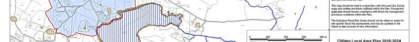
7

         Statutory Planning         Statutory plans, in particular the previous Local Area Plan for the town
         Context                    and the need for compliance and consistency with the current Galway
                                    County Development Plan 2015-2021 and the Regional Planning
                                    Guidelines for the West Region 2010-2022 and emerging Regional
                                    Spatial & Economic Strategy.

         Local Planning             Local plans, strategies and studies, including: the Galway County
         Context                    Heritage and Biodiversity Plan 2017-2022 ; Galway Transportation and
                                    Planning Study 2002; Developing Sustainable Tourism in Galway: A
                                    Framework for Action 2003-2012; and Galway County Local Economic
                                    and Community Plan 2016-2022

         Environmental              Assessment of potential environmental impacts of the Local Area Plan,
         Assessment                 including a Strategic Environmental Assessment, Habitats Directive
                                    Assessment, the Strategic Flood Risk Assessment for County Galway
                                    and a Stage 2 Strategic Flood Risk Assessment for Clifden.

1.4.2 Plan Issues, Considerations and Challenges
The proper planning and sustainable development of Clifden encompasses a wide range of issues, considerations
and challenges, many of which have been highlighted through the consultation process. The plan seeks to balance
the wide ranging, and sometimes competing needs of the local community, landowners and the environment, along
with promoting the important role of Clifden within County Galway. Some of the plans key issues, considerations and
challenges are set out hereunder:

•     Common Vision: A common strategic vision needs to be developed that provides a positive framework for
      future growth, consolidation and enhancement of the town in accordance with the principles of proper planning
      and sustainable development.

•     Core Strategy: The Core Strategy in the Galway County Development Plan has identified a target population
      growth of up to 250 persons for Clifden through to 2021, which results in a requirement for 12.92ha of zoned
      land for residential purposes (based on 50% over-zoning). A key factor in the preparation of the Plan has been
      the determination of the best locations for residential land uses within the town to accommodate this future
      growth and to ensure residential development takes place in an orderly and sequential manner.

•     Population Growth: Clifden has varied but continued population growth over the last two Census periods.
      Ensuring sustainable settlement patterns, including the provision of the necessary planning framework, to
      accommodate educational, community, leisure and recreational facilities to satisfactorily match the level of
      population growth, is a key issue in planning for the future.

•     Infrastructure and Sustainable Transportation: Working towards ensuring that infrastructure is developed
      on an ongoing basis to service future developments in order to accommodate planned population growth,
      whilst ensuring compliance with the statutory obligations to achieve good water quality status under the EU
      Water Framework Directive and associated national legislation. Whilst the opportunities for public transport
      are limited in Clifden, there is scope to focus on promoting and facilitating the use of sustainable modes of
      transport, such as walking and cycling, in and around the town areas and along the Connemara Greenway.
      The reduction of car dependency and promoting Smarter Travel initiatives are also key considerations in the
      Local Area Plan process.

•     Economic Activity and Tourism: Ensuring the enhancement of Clifden’s role as a centre for employment for
      residents of both the town and wider hinterland, through maximising the its tourism opportunity presented by
      its location in Connemara. It is important to foster and maintain local and small scale businesses through
      protecting the vitality and vibrancy of the town centre, promoting and facilitating appropriate tourism ventures,
      while ensuring that Clifden remains an attractive place to work, live, visit and do business.

                                                                                                                     7
8

•   Heritage and Environment: Promoting and facilitating appropriate growth of the town, while protecting the
    built, cultural and natural heritage of Clifden in accordance with applicable legislation and policy. This also
    includes consideration of the environmental designations adjacent to and within the plan boundary.
•   Flooding: Flood risk issues are an important consideration in the preparation of the Local Area Plan,
    particularly in zoning lands for appropriate uses in flood risk areas, and the Local Area Plan is guided by the
    Stage 2 Strategic Flood Risk Assessment for the Clifden LAP area which was carried out as part of the plan
    making process and aligns with the guidance contained within the document The Planning System and Flood
    Risk Management Guidelines for Planning Authorities Guidelines for Planning Authorities (2009), as updated
    and the DECLG Circular PL 2/2014.

                                                                                                                      8
9

2.0 STRATEGIC VISION AND DEVELOPMENT STRATEGY

                                                Vision Statement

     To promote the sustainable development of Clifden, as a prosperous town, providing a focus for future residential,
     economic & social development in west Connemara. Promoting the town as a visitor destination while preserving
     its unique historic identity, character and environmental quality, as well as improving its accessibility.

2.1 Strategic Vision

This plan is underpinned by a strategic vision. This is intended to guide the future growth and development of Clifden
in a sustainable manner, achieving the strategic objectives set out for the town in the Galway County Development
Plan in a way that reflects the existing character and protects the amenity of the area, the surrounding landscape,
heritage, environment and improves the quality of life of residents and the local community.

The strategic vision is informed by the following guiding principles:

•     Realising the town’s potential as the ‘Key Town’ as set out in the Galway County Development Plan and
      attracting the population target established in the Core Strategy up to 2021 and beyond.

•     The growth of Clifden for the life of the plan should focus on establishing new sustainable communities
      adopting a sequential approach to the zoning of residential lands extending outwards from the centre of the
      Town on suitable deliverable sites in line with the Guidelines for Planning Authorities - Sustainable Residential
      Development in Urban Areas (Cities, Towns & Villages) (2009).

•     Ensuring that there are a range of facilities, amenities and supporting services including educational,
      recreational, religious, social, community and civic requirements for children, youths, adults and the elderly, to
      serve a growing community, which promote an inclusive and cohesive local community.

•     Maintaining a strong and vibrant town centre which attracts new businesses and provides appropriate retailing
      and service functions to serve the needs of the Town and its surrounding hinterland, in addition to offering a
      pleasant and attractive environment for shopping, business, recreation and living.

•     Capitalising on the compact urban form of Clifden by encouraging greater connectivity for new development
      which promotes and encourages walking and cycling ensuring that principles of sustainable transportation
      along with practical design measures become central to the development of new neighbourhoods.

•     Promoting sustainable development which minimises negative impacts on the environment and helps to
      mitigate against the likely effects of Climate Change on present and future generations. Including the
      promotion of low-carbon technologies, building and water efficiency as well as the use of renewable
      technologies and sustainable forms of water and wastewater drainage.

•     Integration of high quality design into all future development within the Clifden LAP area, promoting innovative,
      green technologies throughout the plan area which make a positive contribution to the environment.

•     Ensuring all new development within the Architectural Conservation Area, reinforces local distinctiveness and
      creates a sense of place while protecting, conserving and enhancing the historic character of Clifden.

                                                                                                                          9
10

2.2 Development Strategy

2.2.1 Core Strategy Context

A Core Strategy is required under the Planning and Development Act 2000 (as amended) to ensure that the
development objectives of Development Plans/Local Area Plans are consistent, as far as practicable, with national
and regional development objectives. Based on the population targets outlined in the Regional Planning Guidelines,
the Galway County Development Plan identifies a population growth target of 13,160 persons for the County (not
including Galway City) by 2021.

 A key component of the Clifden Local Area Plan 2018-2024 is to ensure that it aligns with the County Core Strategy/
Settlement Strategy as set out in the Galway County Development Plan. The Core Strategy stipulates a population
growth target of 250 persons by 2021 with a housing land requirement of 12.92 ha (which includes a permitted 50%
over provision) in order to accommodate residential development over the plan period. This new plan must consider
the most appropriate residential development options such as phasing, rezoning or de-zoning in order not to exceed
the maximum requirements of the 12.92 ha from the Core Strategy and to ensure that suitable lands are brought
forward for development during the plan period.

2.2.2 Development Options

In order to achieve the strategic vision for Clifden, it is important to examine a number of Development Strategy
Options to ascertain which option can deliver most effectively on the vision for the town.

A number of potential development options are outlined hereunder. These options have been developed having
regard to a number of considerations including the Core Strategy, the settlement hierarchy, the role of the town as
envisaged in the Galway County Development Plan, population and growth trends, the potential growth, the existing
development pattern and character of the town, the existing amenities and environmental sensitivities and the lands
and services available for future development.

Alternative 1: Even Development

•     Clifden to reach population allocation, resulting in balanced orderly development and implementation of the
      core strategy as contained in Chapter 2 of the Galway County Development Plan 2015-2021.

•     The infrastructure required to be in place to achieve the growth targets is already in place or planned.

•     Residential Development to take place on R1 lands in the lifetime of the Plan, unless a comprehensive
      justification is provided for alternative residential lands.

•     Community development facilities to be developed in tandem with economic and residential growth.

•     Town Centre developments would be developed in a planned and coordinated manner focused within the
      town centre.

•     Business and Enterprise development would occur in the periphery close to existing infrastructure.

•     Opportunity sites identified with clear design and proposed uses identified.

•     Open Space and Recreational Lands would be preserved.

                                                                                                                    10
11
Alternative 1.
Alternative 2: Sporadic Development
• Clifden to reach population allocation, contributing towards implementation of the core strategy as contained
in Chapter 2 of the Galway County Development Plan 2015-2021.
• Additional infrastructure would be required to accommodate sporadic development, more than would be
required for Alternative 1 ‘Even Development’.
• Residential Development to take place on R1 and R2 lands in the lifetime of the Plan, unless a evidence
based justification is provided for alternative residential lands.
• Community Facilities to be developed on reserved lands in tandem with economic and residential growth.
Additional community lands to be provided under the alternative along the Galway Road.
• Business & Enterprise development would occur at locations including those close to residential development.
• Town centre development would be sporadic and uncoordinated around the Town centre zonings with an
easterly expansion occurring along the N59 Galway Road.
• Opportunity sites are identified but no clear guidance on the design parameters or uses identified.
Alternative 2.
1112
Alternative 3: Haphazard Development
• Clifden to reach population allocation, contributing towards the implementation of the core strategy as
contained in Chapter 2 of the Galway County Development Plan 2015-2021.
• Additional infrastructure would be required to accommodate sporadic development, more than would be
required for Alternative 1 ‘Even Development’ or Alternative 2 ‘Sporadic Development’, development would
have to be serviced by private waste water treatment systems which would have to be properly maintained.
• Residential development would occur on a piecemeal and haphazard basis.
• Town centre development would be permitted throughout the plan area and not concentrated in the Town
centre.
• No opportunity sites identified-laissez faire attitude in relation to development.
• Each application would be considered on its own merits and no land use zoning is provided. This policy is
applied to all lands within the Plan area—therefore there is no map for this alternative.
2.2.3 Preferred Development Option
After an assessment of the development options presented, Alternative 1 is deemed the preferred Development
Option.
This option includes a refined plan boundary, providing a more appropriate development envelope and greater
certainty to the future growth of the Town, including rationalised land use zonings to align with the Core Strategy. It
also takes account of the infrastructural capacity within the town, with particular regard to water and wastewater
availability and takes cognisance of flood risk areas.
The approach promotes the consolidation of development within the plan area, supports sequential development of
the remainder of the urban area from the centre outwards and ensures that serviced, residential lands close to the
Town centre on less constrained developable sites and sustainable transport options are the primary focus for
development in the short to medium term. This in turn will encourage reduced travel demands, more sustainable
transport options and ease of access to community facilities, employment sources and retail and service provision
within the town centre.
The retail function within the town centre performs a very important focus for the vibrancy and vitality of the town
centre. The mix of retail offer enables the town to attract shoppers from the surrounding hinterland into the centre
and allows the town to maintain its historic draw as an important market town. In addition to this, in Clifden the
provision of services for Tourism are of vital importance to the town’s success. The centre provides accommodation,
restaurants, shopping and public services. Appropriately scaled retail in the right location, including the
redevelopment of brownfield and under utilised sites in the town centre will ensure resilience and assist in reducing
retail vacancy levels. The application of a sequential retail policy looking at existing vacant retail floor space in
advance of edge of centre or out of centre development proposals will reduce vacancy and focus new development
within the existing centre.
A significant portion of the LAP area consists of land heavily constrained by the landscape. A large portion of the
land immediately surrounding the defined town centre are poorly drained and consist of varying steep gradients
unsuitable for development. As a result, to achieve the core strategy zoned Residential Phase 1 land requirement it
has been necessary to extend northwards and southwards from the town centre to zone appropriate lands.
This development option also takes account of the necessary environmental considerations for Clifden. A Stage 2
Strategic Flood Risk Assessment was carried out in tandem with the preparation of the Local Area Plan which
informs future land uses including the avoidance of flood risk areas and the avoidance of inappropriate development.
Green infrastructure and climate change were also keys elements for consideration in the preparation of this Local
Area Plan.
The built heritage, including recorded monuments, National Monuments, buildings on the Record of Protected
Structures, and the designated Architectural Heritage Area and buildings of vernacular interest within the town offer
link to the Town’s past and create a sense of place as well as giving the town its unique character.
1213
Similarly, the natural heritage and biodiversity of Clifden are important features which contribute to the character of
the area and also need to be safeguarded under the preferred development option.
Finally, this preferred Development Strategy Option is informed by the statutorily required environmental assessment
and seeks to enhance sustainability, promote economic and social development and ensure quality of life and the
protection of the environment. It also aligns with and aims to deliver on the Core Strategy requirements set out for
Clifden in the Galway County Development Plan, Regional and National planning policies and Objectives.
Land Use Management and Zoning
In order to deliver on this preferred Development Strategy, a number of scenarios have been considered in relation
to land use management and zoning:
1. Re-zoning of lands.
2. Phasing of development on lands zoned for residential uses.
3. De-zoning of lands.
The rationalising of the plan boundary, the phasing of residential development and the rezoning of certain lands for
environmental reasons as well as an evaluation of deliverability is considered the most appropriate approach at this
time. The zoning of suitable Residential Phase 1 land adjacent to the town centre has proven difficult in this unique
landscape. Relatively level sites, with appropriate access and acceptable drainage were not immediately evident for
zoning. Therefore, zoning of development lands in Clifden, it has been necessary to look both north and south of the
town centre. The lands zoned to the north and south, while appearing visually remote from the town centre are
within approximately 800m, have good accessibility including footpaths from the town centre.
Residential lands have generally been phased in a sequential manner, with Phase 1 residential lands identified for
short to medium term growth in suitable locations that are serviceable and accessible. These lands include infill
sites, extensions to the existing residential fabric and growth areas. The phasing as applied allows for some
flexibility, as detailed by the policies and objectives in the plan, while adhering to the Core Strategy.
The allocation of phase 1 zoned lands has been achieved on the basis of an analysis of the planning history, site
constraints, length of time zoned and land ownership (single or multiple landowners). Analysis of this information has
allowed the consideration of deliverability of lands zoned as phase 1 lands within the lifetime of this Local Area Plan.
All green field/undeveloped lands located within identified flood risk areas (in particular Indicative Flood Zone A and
B) have been rezoned as ‘Open Space/Recreation & Amenity’ in accordance with the Flood Risk Management
Guidelines 2009 and the Departmental Circular PL2/2014, in order to avoid inappropriate development in high to
moderate flood risk areas and to address the potential impacts of climate change. In addition, existing developed
lands have been attributed a ‘Constrained Land Use’ zoning in order to align with the requirements of Circular
PL2/2014. The plan also includes policies and objectives to ensure that the sensitivities of the flood risk areas are
adequately considered, protected and managed as appropriate, in the development management process.
Larger scale employment uses are considered appropriate at existing zoned lands. The defined town centre
remains the primary target for the location of new retail & tourism development, with an opportunity to consolidated
retail core. In addition, the land use zoning matrix provides further guidance on appropriate uses in the various
zones. Overall this is considered to be the most appropriate option at this time for securing the orderly and
sequential development of Clifden.
1314
2.2.4 Development Strategy Policy and Objectives
Development Strategy Policy
Policy DS 1 – Development Strategy
It is the overarching policy of Galway County Council to support and facilitate the sustainable development of the
plan area in line with the preferred development strategy option, Alternative 1 - Even Development with a Refined
Plan Boundary, which allows Clifden to develop in a manner that maintains and enhances the quality of life of the
local community, promotes opportunities for economic development, sustainable transport options, connectivity and
social integration, protects the cultural, built, natural heritage and environment and complies with relevant statutory
requirements.
Development Strategy Objectives
Objective DS 1 – Orderly and Sequential Development
Support the orderly and sequential development of the plan area, focussing on consolidation of development,
continued vitality and viability of the Town centre and the protection and enhancement of the existing landscape
setting, character and unique identity of the town.
Objective DS 2 – Consistency with the Core Strategy
Galway County Council will ensure that developments permitted within the plan area are consistent with the zoned
land allocations in the Core Strategy and associated provisions in the Galway County Development Plan 2015-2021
(as amended).
Objective DS 3 – European Sites Network and Habitats Directive Assessment
Protect European sites that form part of the European Sites network (including Special Protection Areas and Special
Areas of Conservation) in accordance with the requirements in the EU Habitats Directive (92/43/EEC), EU Birds
Directive (2009/147/EC), the Planning and Development (Amendment) Act 2010, the European Communities (Birds
and Natural Habitats) Regulations 2011 (SI No. 477 of 2011) (and any subsequent amendments or updated
legislation) and having due regard to the guidance in the Appropriate Assessment Guidelines 2010 (and any
updated/superseding guidance). A plan or project (e.g. proposed development) within the Plan Area will only be
authorised after the competent authority (Galway County Council) has ascertained, based on scientific evidence and
a Habitats Directive Assessment where necessary, that:
The plan or project will not give rise to significant adverse direct, indirect or secondary impacts on the integrity of
any European Sites (either individually or in combination with other plans or projects); or
The plan or project will adversely affect the integrity of any European Sites (that does not host a priority natural
habitat type and/or a priority species) but there are no alternative solutions and the plan or project must
nevertheless be carried out for imperative reasons of overriding public interest, including those of a social or
economic nature. In this case, it will be a requirement to follow procedures set out in legislation and agree and
undertake all compensatory measures necessary to ensure the protection of the overall coherence of European
Sites; or
The plan or project will adversely affect the integrity of any European Sites (that hosts a priority natural habitat type
and/or a priority species) but there are no alternative solutions and the plan or project must nevertheless be carried
out for imperative reasons of overriding public interest, restricted to reasons of human health or public safety, to
beneficial consequences of primary importance for the environment or, further to an opinion from the Commission,
to other imperative reasons of overriding public interest. In this case, it will be a requirement to follow procedures
set out in legislation and agree and undertake all compensatory measures necessary to ensure the protection of the
overall coherence of European Sites.
Objective DS 4 – Development Management Standards and Guidelines
The general development management standards and guidelines set out under the current Galway County
1415
Development Plan, or any subsequent variation/review, shall apply as appropriate in the plan area. In addition, any
specific development management guidelines set out in Section 3 of this plan shall also be applied, as appropriate,
to development proposals in the plan area.
Objective DS 5 – Service Led Development
Development under the plan shall be preceded by sufficient capacity in the public waste water infrastructure and
potable water infrastructure.
Objective DS 6 – Residential Development Phasing
Direct residential development into appropriately zoned and serviced areas in accordance with the phased
development framework set out in Sections 3.1 and 3.2 and on Map 1- Land Use Zoning.
Objective DS 7 – Flood Risk Management and Assessment
Ensure that proposals for new developments located within identified or potential flood risk areas, or which may
exacerbate the risk of flooding elsewhere, are assessed in accordance with the provisions of The Planning System
and Flood Risk Management Guidelines for Planning Authorities (2009) (or as updated) & Departmental Circular
PL2/2014 and the relevant policies and objectives of this plan. (Refer to Map 3– Flood Risk Management)
Objective DS 8 – Climate Change & Adaptation
Galway County Council shall support the National Climate Change Strategy and National Adaptation Framework
and National Mitigation Plan 2017 (or any updated/superseding document) including the transition to a low carbon
future, taking account of flood risk, soil erosion, the promotion of sustainable transport, improved air quality, the
importance of green infrastructure, the use of renewable resources and the reuse of existing resources.
1516
3.0 DEVELOPMENT POLICIES, OBJECTIVES AND GUIDELINES
3.1 Land Use Management
3.1.1 Context
The Core Strategy of the current Galway County Development Plan 2015– 2021 sets the context and parameters for
the development of Clifden as an identified ’Key Town’ in the county. Based on population projections derived from
the population targets set out in the North West Regional Authority, the amount of zoned residential land required to
facilitate this target is set at 12.92 hectares for the time period up to 2021. Lands have also been zoned for other
land uses in the plan, including town centre/commercial, business/enterprise, community facilities, open space/
recreation and amenity and constrained land uses. In addition, a number of ‘opportunity sites’ have been identified
within the plan area. These are underutilised sites in central locations with good development prospects which the
Council would encourage to be brought forward for development within the lifetime of this Local Area Plan.
The land use zonings within the Clifden LAP are based on Clifden’s role in the Core Strategy/Settlement Strategy,
existing land use patterns, and projected needs derived from medium and long term population targets. The
optimum utilisation of existing and planned infrastructure is also a key consideration in the development of this land
use framework.
3.1.2 Policies and Objectives
Land Use Management Policies
Policy LU 1 – Land Use Management
It is the policy of Galway County Council to provide a land use zoning framework for the plan area, to direct the type,
density and location of development, in a manner that contributes to the consolidation of the town centre, and is in
compliance with the statutory requirements of the Planning and Development Act, 2000 (as amended). The land use
zoning framework is supported by a residential phasing scheme to ensure compliance with the Core Strategy and to
promote orderly and sequential development of the town.
Land Use Management Objectives
Objective LU 1 – Town Centre/Commercial (C1)
Promote the development of the town centre as an intensive, well connected, high quality, well-landscaped, human-
scaled and accessible environment, with an appropriate mix of uses, including residential, commercial, service,
tourism, enterprise, public and community uses as appropriate, that provide a range of retail, services, facilities and
amenities to the local community and visitors. The town centre and associated main streets shall remain the primary
focus for retail and service activity within Clifden.
Objective LU 2 – Residential (R)
Promote a phased, sequential approach on Residential zoned lands, with a strong emphasis on consolidating
existing patterns of development, encouraging infill opportunities and promoting sustainable transport options.
It is an objective to:
a) Promote the development of appropriate and serviced lands to provide for high quality, well connected and well
laid out and landscaped sustainable residential communities with an appropriate mix of housing types and densities,
together with complementary land uses such as community facilities, local services and public transport facilities, to
serve the population of the area.
1617
b) Protect existing residential amenities and facilitate compatible and appropriately designed new infill
development, in accordance with the proper planning and sustainable development of the area.
A phasing scheme shall apply to residential uses on Residential (R) zoned lands, as set out under Objective RD1
in Section 3.2.2.
Objective LU 3 – Business & Enterprise (BE)
Promote the development of business and enterprise uses, light industry/warehousing and the facilitation of
enterprise park/office park type uses to include incubation/start-up units and Small Medium Enterprises, on suitable
lands with adequate services and facilities and with a high level of access to the major road networks and to public
transport facilities.
Objective LU 4– Community Facilities (CF)
Promote the development of community facilities on suitable lands, with a high level of access to the local
community, including educational, community, civic, public, institutional, recreational, cultural and other
complementary uses, as appropriate.
Objective LU 5 – Open Spaces/Recreation & Amenity (OS)
Promote the sustainable management, use and/or development, as appropriate, of the OS lands.
This will include the:
a) Development of open spaces, sport and recreational activities, in accordance with best practice and on
appropriate lands with suitable levels of access to the local community.
b) Existing open space, sport and recreational facilities, should be retained unless it can be clearly
demonstrated to the satisfaction of Galway County Council that these uses are surplus to requirements of
the local community or are to be replaced by an equivalent or better provision ;
c) Appropriate management and use of any flood risk areas within the OS zone to avoid, reduce and/or
mitigate, as appropriate, the risk and potential impact of flooding;
d) Appropriate management and use of any areas of high biodiversity value.
Objective LU 6 – Public Utilities (PU)
Facilitate the provision and maintenance of essential public utility infrastructure, together with the necessary
ancillary facilities and uses, as appropriate.
Objective LU 7 – Transport Infrastructure (TI)
Facilitate the provision and maintenance of essential transportation infrastructure. This shall include the reservation
of lands to facilitate public roads, footpaths, cycle ways, bus stops and landscaping together with any necessary
associated works, as appropriate.
Objective LU 8—Tourism (TO)
To promote and facilitate sustainable tourism development within Clifden. Encouraging the town to expand its
range of services, facilities and tourism infrastructure which are necessary for the industry to grow and thrive, for
the benefit of the town and its surrounding areas.
Objective LU 9 – Constrained Land Use Zone (CL)
To facilitate the appropriate management and sustainable use of flood risk areas.
This zoning limits new development, while recognising that existing development uses within these zones may
require small scale development, as outlined below, over the life of the Local Area Plan, which would contribute
towards the compact and sustainable urban development of the town.
The underlying zoning or the existing permitted uses are deemed to be acceptable in principle for
minor developments to existing buildings (such as small extensions to houses, most changes of use of existing
buildings), which are unlikely to raise significant flooding issues, provided they do not obstruct important flow paths,
introduce a significant additional number of people into flood risk areas or entail the storage of hazardous
substances.
1718
Development proposals within this zone shall be accompanied by a detailed Flood Risk Assessment, carried out in
accordance with The Planning System and Flood Risk Assessment Guidelines & Circular PL 2/2014 (or as
updated), which shall assess the risks of flooding associated with the proposed development.
Proposals shall only be considered where it is demonstrated to the satisfaction of the Planning Authority that they
would not have adverse impacts or impede access to a watercourse, floodplain or flood protection and management
facilities, or increase the risk of flooding to other locations. The nature and design of structural and non-structural
flood risk management measures required for development in such areas will also be required to be demonstrated,
so as to ensure that flood hazard and risk will not be increased. Measures proposed shall follow best practice in the
management of health and safety for users and residents of the development.
Specifications for developments in flood vulnerable areas set out in this plan shall be complied with as appropriate.
(Please also refer to Objective FL3 & DM Guideline FL 2)
Objective LU 10 - Galway County Development Plan 2015-2021 (as varied)
The provisions of the Galway County Development Plan 2015—2021 (as varied), including the measures
contributing towards environmental protection and sustainability (some of these measures are repeated in Section 9
of the SEA) Environmental Report that accompanies this Plan) shall be complied with by any future development.
Objective LU 11 – Flood Risk Areas and Land Use Zones (Refer to Map 1, 2 and Map 3)
Ensure that any proposed development that may be compatible with the land use zoning objectives/matrix but which
includes a use that is not appropriate to the Flood Zone (as indicated on Map 8 – Flood Risk Management) and/or
that may be vulnerable to flooding is subject to flood risk assessment, in accordance with The Planning System and
Flood Risk Management Guidelines for Planning Authorities 2009 and the Departmental Circular Pl 2/2014 (or as
updated within the lifetime of this plan) and the policies and objectives of this plan.
Objective LU 12 – Land Use Zoning Matrix (Refer to DM Guideline LU 2)
Direct different land uses into the appropriate land use zone(s) in accordance with the land use zoning objectives
and the land use zoning matrix set out under DM Guideline LU2. Ensure that proposed land uses are compatible
with existing land uses and in keeping with the character of the area.
Objective LU 13– Opportunity Sites
To encourage and support the appropriate and sustainable development of lands identified on Zoning Map 2, to
positively contribute to the vitality and character of Clifden.
Land Use Density Objectives
Objective LUD 1 – Development Densities
Ensure that the density of new development is appropriate to the land use zone and site context, is in keeping with
the development pattern of the area, does not unduly impact on the amenities of the area and that it results in a
positive relationship between existing developments and any adjoining public spaces. The development of higher
density development shall be promoted in appropriate locations, such as suitable sites within the Town centre and
adjacent to public transport facilities, where such development is compatible with the built & natural heritage, urban
design objectives, infrastructure capacity and environmental considerations. The density of developments will
generally be in accordance with the guidance set out under DM Guideline LU1, although the Planning Authority may
consider higher density developments where this is deemed appropriate to secure the urban design or other
objectives of the plan.
Objective LUD 2 – Residential Densities
Promote a range of residential densities within the plan area appropriate to the prevailing development pattern,
1819
supporting infrastructure, urban character and heritage resources in accordance with the guidance in ‘Sustainable
Residential Development in Urban Areas Guidelines 2009’ (or as updated within the lifetime of this plan). Higher
residential densities should be encouraged at locations where it is appropriate to the existing context and density of
the plan area, for example around the town centre and within convenient walking distance of public transport
facilities, and where it will not unduly impact on built or natural heritage or impact adversely on the integrity of
European Sites. The density of residential developments will generally be in accordance with the guidance set out
under DM Guideline LU1, although the Planning Authority may consider higher residential densities where this is
considered appropriate to the context and necessary to secure the urban design or other objectives of the plan.
Development will only be permitted where there is capacity and/or adequate services can be made available.
Development Management Guidelines
DM Guideline LU 1 – Development Densities
The development density guidance in the tables below indicate the range of densities generally considered
appropriate in the various land use zones and in different residential locations within the plan area.
Land Use Zone Plot Area Ratio Maximum Site Coverage Minimum Public Open Space
Zone C1 1.00 to 1.25 PAR 80% Site Specific
Zone R 0.10 to 0.50 PAR 50% 15%
Zone BE 0.40 to 1.00 PAR 60% 15%
Zone CF Site Specific Site Specific 15%
Zone OS Site Specific Site Specific Site Specific
Zone PU Site Specific Site Specific Site Specific
Zone CL Site Specific Site Specific Site Specific
Zone TI N/A N/A N/A
Zone A Site Specific Site Specific Site Specific
Zone TO Site Specific Site Specific Site Specific
Notes:
1) Plot Area Ratio – Plot area ratio refers to the gross floor area of buildings on a site divided by the gross site area,
where the gross floor area is expressed as a fraction of the gross site area.
2) Site Coverage – Site coverage refers to the percentage of gross floor area of the building(s) footprint on the
site. Increased site coverage may be considered on sites where underground or part-basement parking is provided,
subject to high standards of design, adequate natural lighting and the protection of the amenity of adjacent
developments.
3) Public Open Space – Public open space generally refers to usable, well-located green areas but in certain cases
may also include paved areas that can be used for recreation, that are well-landscaped and that form an integral part
of the development. Public open space would generally only be required in non-residential and multiple unit
residential developments.
1920
Residential Dwelling Units/ Dwelling Units/
Possible Appropriate Locations
Density Ha Acre
Medium to High 35 - 50 14 - 20 Town centre or immediately adjacent to public transport hubs.
Neighbourhood centres (typically within 400m walking distance of centre point),
Low to Medium 15 - 35 6 -14
inner urban suburbs.
Low 5 -15 2-6 Urban periphery, outlying lands, areas with capacity/environmental constraints.
DM Guideline LU2 – Land Use Zoning Matrix
The land use zoning matrix indicates the types of land uses that are Permitted in Principle (P), Open for
Consideration (O) and Not Normally Permitted (N), for the land use zones designated in Section 3.1.1 above. Whilst
the matrix does not provide an exhaustive list of potential uses, the uses listed in the matrix should be considered by
applicants to provide a clear indication of the overall acceptability of a particular land use within a specific zoning
category. Where a use is proposed that is not listed in the matrix, development proposals will be assessed on their
individual merits in accordance with the general guidance provided by the matrix and having regard to the nature of
existing and proposed uses, to the general policies and zoning objective(s) for the area in the Local Area Plan and
to the principles of proper planning and sustainable development. Where there is no perceived conflict between
existing and proposed uses, favourable consideration will be given to the proposed development, subject to all other
normal requirements and to the principles of the proper planning and sustainable development of the area. The land
Use Zoning Matrix is intended as a guide to assist users of the Local Area Plan in relation to the types of uses that
may be considered under each of the land use zonings. The matrix in isolation will not prohibit an appropriate
development and each application will be considered on its merits and in accordance with proper planning and
sustainable development.
(Please also refer to Maps 1, 2 – Land Use Zoning & Map 3– Flood Risk Management)
Land Uses
Commercial and Industrial Uses C1 R BE CF OS* A PU TI TO
Amusement O N N N N N N N N
ATM P O O O N N N N O
Bank/Building Society P N N N N N N N N
Bar/Restaurant P N N N N N N N O
B&B (Bed & Breakfast)1 O O1 N N N O1 N N O
Betting Office O N N N N N N N N
Café2 P O O2 O N N N N O
Cash & Carry N N P N N N N N N
C1 R BE CF OS* A PU TI TO
Casual Trading O N N N N N N N N
Cinema P N N N N O N N N
Conference Centre P N N O O O N N N
Data-Centres/Web-Hosting Centres4 P N O P P N N O O
Drive-through Restaurant O N N N N N N N N
Enterprise Centre O N O O P N N O O
Extractive Industry N N N N N N N O N
20You can also read