Ballycullen-Oldcourt Draft Local Area Plan 2013 - South ...
←
→
Page content transcription
If your browser does not render page correctly, please read the page content below
Ballycullen-Oldcourt
Draft Local Area Plan
2013
‘A place … that builds upon … its setting within the foothills of the Dublin Mountains and … countryside; a
permeable place that links … a network of pedestrian and cyclist paths … local shopping ... quality streets and
useful spaces … through the sensitive and considered incorporation of mountain views, vistas of local historic
structures, hedgerows, streams, townland and parish boundaries and archaeology; a developing area that retains
a clear delineation between the suburbs and the countryside...’
Ballycullen - Oldcourt Draft Local Area Plan																						Contents

CONTENTS                                                                                            Appendix............................................................................................43   Ballycullen-Oldcourt
                                                                                                    Appendix 1: Plan Objectives
Executive Summary…………..........……………...................…….…...4                                     Appendix 2: Standards & Design Criteria                                                                  Draft Local Area Plan
                                                                                                    Appendix 3: Development Plan Objectives & Policies                                                       October 2013
1.0    Introduction.............................................................................5   Appendix 4: Policy & Strategic Context
1.1    Context                                                                                      Appendix 5: Protected Structures & Recorded Sites & Monuments                                            This Local Area Plan was prepared under the direction of Frank
1.2    What is a Local Area Plan?                                                                   Appendix 6: Street Typologies for Plan Lands                                                             Nevin, Director of Land Use, Economic and Transport Planning, by
1.3    Rationale for Preparation of Local Area Plan & Boundary                                                                                                                                               the following staff:
1.4    Environmental Assessments
1.5    Pre-Draft Public Consultation                                                                                                                                                                         Local Area Plan Project Team:-
1.6    Planning Status and Period of Local Area Plan                                                                                                                                                         Paul Hogan..................................................................... Senior Planner
1.7    Vision, Plan Objectives & Settlement Statement                                                                                                                                                        Dara Larkin......................................................Senior Executive Planner
                                                                                                                                                                                                             Jason Taylor....................................................................Urban Designer
2.0    Development & Population Analysis…………............…...…8                                                                                                                                               James Phelan.............................................................Executive Planner
2.1    Description of Plan Lands                                                                                                                                                                             Tracy McGibbon..........................................................Executive Planner
2.2    Ballycullen - Oldcourt Action Area Plan (2000)                                                                                                                                                        Padraic Larkin................................................................Chief Technician
2.3    Development Plan Zoning of Plan Lands
2.4    Development Status of Plan Lands                                                                                                                                                                      Additional Departmental Input:-
2.5    Residential Development and Density                                                                                                                                                                   Corporate Services Department
2.6    Commercial and Community Floorspace                                                                                                                                                                   Roads and Water Services Department
2.7    Building Heights and Composition                                                                                                                                                                      Environmental Services Department
2.8    Population and Housing Statistics                                                                                                                                                                     Community Services Department
2.9    Schools
2.10   Movement
2.11   Traffic Noise
2.12   SCOT Analysis

3.0    Existing Green Infrastructure………………...................……17
3.1    Introduction
3.2    Built Heritage
3.3    Natural Heritage
3.4    Water Management and Flood Risk

4.0    Plan Rationale.......................................................................20
4.1    Introduction
4.2    Vision & Plan Objectives
4.3    Development Areas Rationale
4.4    Green Infrastructure Rationale
4.5    Streets Rationale
4.6    Land Use and Density Rationale

5.0    Framework Strategies…………………………………………23
5.1    Introduction
5.2    Accessibility and Movement Strategy
5.3    Green Infrastructure Strategy
5.4    Land Use and Density Strategy
5.5    Built Form & Design

6.0    Phasing.................................................................................38
6.1    Introduction
6.2    County Settlement Strategy Context
6.3    Phasing Strategy
6.4    Quantum of Development

South Dublin County Council							Development, Economic and Transport Planning Department							October 2013                                                                                                                                                                                         3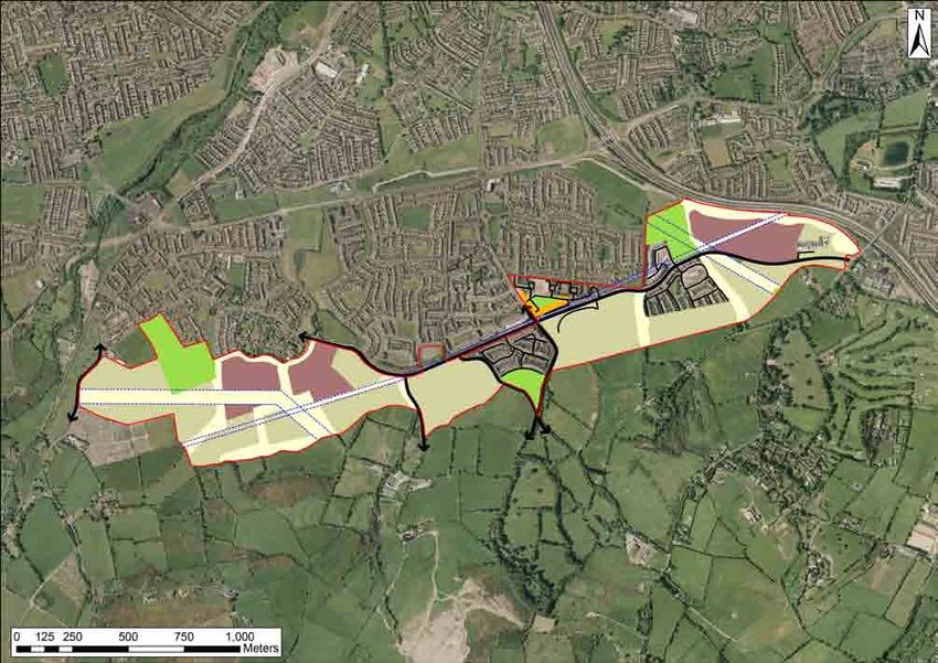
Executive Summary																				                                                                                                                                                 Ballycullen - Oldcourt Draft Local Area Plan

EXECUTIVE SUMMARY                                                               The strategy directs land uses and densities within three distinct areas      4. Built Form
Need for this Plan                                                              (lower slope lands, mid slope lands and upper slope lands) where              The Built Form Strategy sets out to ensure that development, at a wider
A new Local Area Plan (LAP) is required for the Ballycullen-Oldcourt            densities will vary according to context. The majority of the subject lands   level, is carried out in an integrated, coherent and universal design led
area in South Dublin for the following reasons:                                 are zoned for residential development (Objective A1) under the County         manner that responds to local contexts and accords with the core design
• Approximately 90 Hectares (222 acres) of undeveloped lands along              Development Plan and this is reflected under the density strategy.            principles on urban design, place making and street design as set out
    the Ballycullen-Oldcourt fringe is zoned as ‘Objective A1’ (To provide                                                                                    under the relevant government guidelines including the recent Design
    for new residential communities in accordance with approved action          In addition to the recently permitted discount foodstore off Oldcourt Road    Manual for Urban Roads and Streets. The strategy is accompanied by
    plans) under the current County Development Plan;                           on land already zoned LC i.e. “To protect, provide for and/or improve local   a comprehensive layout for the entire Plan Lands, which illustrates how
• There is no existing plan for the West Oldcourt zoned land and there          centre facilities”, this LAP reinforces the provision of a neighbourhood/     they could be developed down to individual site and plot level.
    have been changes in the economic, environmental and social                 local centre off Stocking Avenue on lands that were previously subject
    context for the area since the Ballycullen–Oldcourt Action Area Plan        to a permission for retail and community uses. Further provision is made      Phasing
    (2000) was prepared;                                                        for local retail and community uses on the western side of the Plan           The purpose of phasing is to ensure that facilities and amenities are
• While permissions were granted for approximately 1,800 dwellings              Lands including the Discount Foodstore site.                                  provided in a timely manner either prior to or in tandem with residential
    on the Ballycullen lands between 2000 and 2012 (of which 640 have                                                                                         development rather than at the latter stages of residential development
    been built), many of the permitted developments are no longer viable        Recommended densities vary from low to medium density depending on            or after such development has taken place.
    under the current housing market and economic circumstances;                elevation and location (see table below). The prescribed net residential
• The education, community and recreational facilities have not kept            densities exclude primary roads, green buffers, primary school sites,         For the purpose of the Phasing Strategy, the Plan Lands are divided
    pace with residential development that has recently occurred along          local shopping facilities and large neighbourhood parks.                      into eastern and western sections using the Ballycullen Road as the
    Stocking Avenue and parts of the Oldcourt Road and Hunters                                                                                                point of division. The strategies for each of the two areas comprise three
    Roads;                                                                      Recommended Densities                                                         phases. Each phase specifies a quantum of residential development
• There is a need to provide a robust Sustainable Urban Drainage                 Character Area                       Net Density per Ha.                     and prescribed key pieces of physical and social infrastructure including
    Framework for the development of these lands in view of the surface                                                                                       community facilities that must be provided prior to the next phase of
                                                                                 Lower Slope Lands                    32 – 38 dwellings                       development. This will help to ensure that key pieces of infrastructure
    water drainage problems that have become apparent downstream
    of the culverted sections of the Ballycullen Stream;                         Mid-Slope Lands                      22 – 28 dwellings                       are delivered in a sequential manner as development progresses.
• There are a series of challenges presented by the potential                    Upper Slope Lands                    12 – 18 dwellings
    development of the suburban-rural fringe along the foothills of the                                                                                       Two primary schools will be required to meet the existing and future
    Dublin Mountains that are best met by means of a new LAP.                   2. Green Infrastructure                                                       population needs of the Plan Lands and its surrounding suburban
                                                                                The Plan’s Green Infrastructure Rationale comprises three main strands        hinterland.
The Strategy                                                                    that includes for the sustainable management of water incorporating
The overall objective of the LAP is to provide a development framework          Sustainable Urban Drainage (SUDS) features; pedestrian and cycle              Phase One on the eastern side of the Plan Lands largely relates to
with residential densities appropriate to the unique location of the            routes (tracks and trails); and the provision of a network of green spaces    lands that are subject to extant permissions for residential development.
lands on the suburban edge of the Dublin Mountain foothills. The Plan           in the form of open spaces, linear spaces and landscaped buffers. The         The phasing strategy incentivises revised applications for residential
provides for the construction of approximately 1,600 additional dwellings       proposed open spaces tie in with existing open space provision in             development on these lands.
(about 4,600 persons) at a range of densities appropriate to the area.          Knocklyon and Oldcourt and provision is made for a walking trail along
The strategy complies with the requirements of the Core Strategy of the         most of the 120 metre contour. Open space will be provided over and           Quantum of Development
County Development Plan 2010 – 2016 and that of the Guidelines for              above County Development Plan standards on the basis of:                      It is envisaged that approximately 1,600 additional dwellings would
Planning Authorities on Sustainable Residential Development in Urban            • the location of the Plan Lands within the foothills of the Dublin           be constructed (approx. 1,450 if electrical transmission lines are not
Areas (2009).                                                                        Mountains where lower densities are planned,                             relocated) if all undeveloped lands within the Plan Lands, including lands
                                                                                • the need to preserve extensive natural heritage features,                   subject to extant permissions, were to be developed in accordance with
The phasing element provides for the required community, school and             • the existence of significant utility lines that requires extensive          the standards and objectives contained within this Plan. The number of
parkland facilities either prior to or in tandem with additional residential         wayleave setbacks,                                                       dwellings would increase to 2,200 (2,050 if the transmission lines are not
dwellings. The combined development strategies integrates planned               • the need to provide for an extensive Sustainable Urban Drainage             relocated) if existing planning permissions for residential development
residential neighbourhoods with natural and built heritage features,                 System network to prevent flooding within the Plan Lands and             on lands subject to extant permissions were fully constructed and the
water management systems, improved accessibility, open spaces and                    downstream of the Plan Lands.                                            remaining undeveloped lands were developed in accordance with this
recreational facilities. This includes for a network of walking and cycling                                                                                   Plan.
routes that will link residential blocks with each other, public transport      3. Accessibility and Movement
stops and local shopping while providing routes towards the Dublin              The Accessibility and Movement Strategy seeks to open up the
Mountains.                                                                      Plan Lands with a clear hierarchy of integrated streets for universal
                                                                                movement including pedestrian, vehicular and cyclist activity and sets
1. Land Use and Density                                                         out a framework for such. This will comprise the upgrade of Stocking
This Local Area Plan’s Density Strategy responds to the peripheral              Avenue, Hunters Road and Oldcourt Road as a primary (Main Link)
location of the Plan Lands, the need to create a soft transition between        street for movement across the Plan Lands and to areas outside the
the suburbs and countryside and the need to protect the setting of the          Plan Lands including towards the mountains. A further primary street will
Dublin Mountains including the sloping topography, visual prominence            link the Oldcourt Road with the Bohernabreena Road.
and natural heritage features such as hedgerows and streams. Densities
also reflect the constraints created by the major utility lines that traverse   The planned street network provides for movement at a local level and
the Plan Lands and the need to counterbalance some of the higher                at wider levels across the Plan Lands with links towards surrounding
density residential development that has taken place on the eastern             areas including the Dublin Mountains. This simple structure will ensure
side of the Plan Lands.                                                         that development is permeable, legible and offers a choice of routes.

4 					South Dublin County Council					                                                                     Development, Economic and Transport Planning Department				                                   October 2013
Ballycullen - Oldcourt Draft Local Area Plan																						Introduction

1.0 INTRODUCTION                                                                 Ballycullen–Oldcourt fringe, and the County Development Plan                              •     The necessity to provide a robust Sustainable Urban Drainage
1.1 Context                                                                      requirement for residential development on such lands to be carried                             Framework for the development of these lands in view of the
The Ballycullen-Oldcourt Lands (125 hectares) stretch across the                 out in accordance with approved Area Plans;                                                     restricted surface water drainage capacity downstream.
foothills of the Dublin Mountains and form a buffer between the suburban     •   The residential development that has recently occurred along
areas of Tallaght, Firhouse and Knocklyon with the Dublin Mountains.             Stocking Avenue and parts of the Oldcourt Road and Hunters Road                           1.4 Environmental Assessments
The area benefits from views of its suburban and urban hinterland while          where community, education and recreational facilities have not                           The Plan Lands include areas that are potentially sensitive in terms of
retaining a unique semi-rural setting and mountainous backdrop.                  kept pace with residential development;                                                   biodiversity and conservation. The Planning Authority is of the opinion
                                                                             •   The need to address the challenges presented by the potential                             that this Local Area Plan, if made, would be likely to have significant
This rural-suburban fringe has been zoned for development under                  development of the rural fringe along the foothills of the Dublin                         effects on the environment. An Environmental Report and Appropriate
previous County Development Plans and under the current South                    Mountains, which has a unique amenity value in terms of natural                           Assessment Screening have therefore been undertaken as part of the
Dublin County Council Development Plan, 2010 - 2016. An Action Area              and built heritage;                                                                       production of this Local Area Plan and the assessment and mitigation
Plan was prepared for the eastern part of the lands in 2000 and some         •   The need to ensure that any further development retains as much                           measures have been assimilated. The Environmental and Appropriate
development has commenced in this area along Stocking Avenue. A                  of the character of the foothills of the Dublin Mountains as possible                     Assessment reports are available as separate documents.
significant amount of lands that are zoned for development remain                and sensitively addresses the contrast between new development,
undeveloped (approx. 85%) with a substantial quantum of permitted                existing development and the countryside;
residential development that is yet to commence along or off Stocking        •   The challenges presented for potential future development by the
Avenue.                                                                          noise and traffic generated by the adjacent M50 motorway;
                                                                             •   The need to maintain and improve access to the Dublin Mountains
The slowdown in pace of development creates an opportunity to carry              for the pusposes of tourism and recreation;
out an updated assessment of the entire area and to formulate a Local
Area Plan (LAP) that reflects changing economic, environmental and
social circumstances in a comprehensive manner.
                                                                             Fig. 1.1 Boundary of Plan Lands
This document is the Draft Local Area Plan for public consultation with              Plan Lands
all relevant parties including, in particular, key stakeholders such as
residents and landowners.

1.2 What is a Local Area Plan?
A Local Area Plan is a statutory document prepared by the Planning
Authority in accordance with the requirements of Sections 18, 19 and 20
of the Planning and Development Act, 2000 (as amended). A Local Area
Plan must consist of a written statement and a plan or plans that are
consistent with the objectives of the County Development Plan, its core
strategy, and any regional planning guidelines that apply to the area of
the Plan. Once adopted by the members of the Council, the Planning
Authority and An Bord Pleanála must have regard to a Local Area Plan
when determining planning applications in the area covered by the Plan.
The authority or the Bord may also consider any draft local plan which
has been prepared but not yet made.

1.3 Rationale for Preparation of Local Area Plan & Boundary
Figure 1.1 details the extent of the Plan Lands (outlined in red) to which
this Local Area Plan relates. The Plan Lands were identified for the
preparation of a new Plan on the basis of:
• The approximate 90 Hectares (222 acres) of undeveloped lands
     along the Ballycullen-Oldcourt fringe that is zoned for residential
     development;
• The absence of any previous plan for West Oldcourt and changes in
     the economic, environmental and social context for the area since
     the Ballycullen–Oldcourt Action Area Plan (2000) was prepared;
• The existence of approximately 40 hectares (98 acres) of land along
     or off Stocking Avenue that is subject to planning permissions for
     relatively high density residential development (including apartment,
     duplex and triplex units) that may not now be developed;
• The expiry of permission for a local centre off Stocking Avenue,
     which was to provide for (inter alia) crèche, community and retail
     floorspace;
• The strategic positioning of the (Objective A1) residential zoned
     land, which forms an almost continuous linear land bank along the                                                               Source: Ordnance Survey Irelend & South Dublin County Council

South Dublin County Council							Development, Economic and Transport Planning Department							October 2013                                                                                                                                  5
main street & an Oldcourt suburban and rural fringe under previous County Development Plans.
linked with a A significant amount of lands were zoned for development along the Ballycullen-
neighbourhoods BALLYCULLEN - OLDCOURT?
Introduction Ballycullen - Oldcourt Draft Local Area Plan Create
WHY A LOCAL AREA PLAN FOR
1.5 Pre-Draft Public Consultation Table 1.1: IssuesTO FIND
Raised OUT
under MORE
Pre-Plan AND MAKE
Consultation A SUBMISSION: Fig. 1.2 Front Cover of Pre-Draft Consultation Leaflet
Submissions
ARE
South Dublin County Council undertook a programme of pre-draft public 4:00pm Friday of
Public consultation will take place untilNumber
Category Heading 10 of%Mayof 2013.
Issues
th
This leaflet and
consultation in preparation for this Draft Local Area Plan over a four other information can be viewed on the Council’s website www.sdcc.ie. Information can
Times Raised Raised
also be viewed at County Hall - Tallaght, Tallaght Library and at Whitechurch Library -
week period between Monday the 15th of April 2013 and Friday the 10th Ballyboden during normal opening hours (excluding public holidays).
Acknowledgement of Consultation 3 0.9%
YOU
of May 2013.
Built Form and Building Heights
Council staff will be 28 queries at
available to answer 5.7%
Staff will also be available every
Quaker House, Stocking Lane at the following times: Wednesday afternoon between
This programme included the publication of notices on social media Details of Local Area Plan 16 3.4%
2.00pm - 4.00pm at County
READY
sites, the Council’s website and in the Tallaght Echo; the placement Dumping and Builders’Day
Rubble Date 12Time Hall
3.4%- Tallaght, during the public
consultation to answer queries.
of displays in County Hall (Tallaght), County Library (Tallaght) and Wednesday
Extant Planning Permissions
24th April 4:00 - 7:00 pm
6 1.7%
Whitechurch Library (Ballyboden); the placement of posters in local Thursday 25th April 1:00 - 4:00 pm
Extent of Plan LandsTuesday 1 - 7:00 pm 0.3%
TO HAVE
30th April 4:00
shops and along Oldcourt Avenue, Allenton Road, Oldcourt Road,
Hunters Road, Ballycullen Road and Stocking Avenue; the issue of a Flooding, Drainage & Friday
Streams 3rd May 11 - 4:00 pm
1:00 3.4%
press release; a leaflet drop to residential and commercial premises Green Infrastructure 28 8.0%
within the Plan Lands; the postage of letters to stakeholders including Housing Density, Tenure and Mix 11 3.4%
YOUR
landowners, local community/residents’ groups, commercial interests, Land Ownership 1 0.3%
business interests, public sector agencies, non-governmental agencies
Links to Dublin Mountains 7 2.0%
and those that made submissions during pre-draft consultation for a SUBMISSIONS 17
SAY?
proposed plan for Oldcourt in 2006; the organisation of four public Local Retail and Service Facilities 5.2%
information sessions providing one to one consultations; and provision Maintenance of Public Realm
Submissions 1 to the pre-draft local
and observations in relation 1.1%
area plan consultation can be PUBLIC CONSULTATION dlarkin@sdublincoco.ie
made in writing only to the addresses below by 4.00pm Friday 10th of May 2013.
Phelan at 4149000 extension 2394 jphelan@sdublincoco.ie or Dara Larkin at 4149000 extension 2391
for Council staff to answer queries at County Hall one afternoon a week
PRE-DRAFT LOCAL AREA PLAN Queries relating to Ballycullen - Oldcourt Pre-Draft Local Area Plan Consultation may be made to James
Parks, Open Spaces and Playgrounds 31 8.6%
FURTHER INFORMATION
during the public consultation period. Phone and e-mail contact details Only submissions received by 4.00pm Friday 10th of May 2013 and addressed as set out
Pedestrian, Bicycle Routes
below and Facilities
will be considered. Submissions24 7.7%
cannot be accepted in any other format or to any
were also distributed for additional queries. other e-mail or postal address.
A PLAN FOR THESE ZONED LANDS
Phasing 20 6.0%
County Hall, Tallaght, Dublin 24.
TO BE HEARD AND TO HELP SHAPE
Planning Department, South Dublin County Council,
THIS IS OUR TIME FOR OUR IDEAS Forward Planning Section, Economic & Transport
Council staff spoke to some 70 people on a one to one basis and a Principle of Development or observations
Submissions and Development should27 8.3%
state the name, address and where relevant, the
Address: Administration Officer,
Mountains.
Ballycullen - Oldcourt includes a ballycullenoldcourt@sdublincoco.ie Email:
body represented. stretches across the foothills of the Dublin
total of 55 written submissions were received during the pre-plan Plan Zoning belt of zoned undeveloped lands that belt of zoned undeveloped lands that
body represented.
stretches across the foothills of the Dublin
Ballycullen - Oldcourt includes a Submissions and observations should state the name, address and where relevant, the
consultation period. In addition, 6 letters of acknowledgment were Public Transport andEmail:
Facilitiesballycullenoldcourt@sdublincoco.ie
28 8.3% Mountains.
other e-mail or postal address.
received from public sector agencies. Table 1.1 sets out a brief outline
below will be considered. Submissions cannot be accepted in any other format or to any
Roads and Traffic Address: Administration Officer,19 5.2% SAY? Only submissions received by 4.00pm Friday 10th of May 2013 and addressed as set out
of the issues raised under the submissions and provides details on the Forward Planning Section, Economic & Transport THIS IS OUR TIME FOR OUR IDEAS
made in writing only to the addresses below by 4.00pm Friday 10th of May 2013.
School Provision Planning Department,20 5.7%
South Dublin County Council,
Submissions and observations in relation to the pre-draft local area plan consultation can be
number of times that each issue was raised. All issues raised were YOUR TO BE HEARD AND TO HELP SHAPE
County Hall, Tallaght, Dublin 24. SUBMISSIONS
Sports and Community Facilities 16 4.9% A PLAN FOR THESE ZONED LANDS
taken into consideration during the preparation of this Draft Local Area
Plan particularly those that were made most frequently. Strategic Environmental Assessment 5 1.4%
TO HAVE
Incomplete Estates 16 4.9% 1:00 - 4:00 pm 3rd May Friday
1.6 Planning Status and Period of Local Area Plan FURTHER INFORMATION
READY 4:00 - 7:00 pm
1:00 - 4:00 pm
30th April
25th April
Tuesday
Thursday
This Local Area Plan partly relates to lands that were the subject of Queries relating to Ballycullen - Oldcourt Pre-Draft Local Area Plan Consultation may be made to James PRE-DRAFT LOCAL AREA PLAN
consultation to answer queries.
Hall - Tallaght, during the public
4:00 - 7:00 pm
Time
24th April
Date
Wednesday
Day
Phelan at 4149000 extension 2394 jphelan@sdublincoco.ie or Dara Larkin at 4149000 extension 2391
the Ballycullen – Oldcourt Action Area Plan (2000) and will supersede dlarkin@sdublincoco.ie
YOU PUBLIC CONSULTATION
2.00pm - 4.00pm at County
Wednesday afternoon between Quaker House, Stocking Lane at the following times:
the previous plan, if adopted. The Framework Strategy Maps and
Staff will also be available every Council staff will be available to answer queries at
Illustrated Layouts contained within this Local Area Plan give a
ARE Ballyboden during normal opening hours (excluding public holidays).
also be viewed at County Hall - Tallaght, Tallaght Library and at Whitechurch Library -
other information can be viewed on the Council’s website www.sdcc.ie. Information can
graphical representation of the written policies and proposals contained
Public consultation will take place until 4:00pm Friday 10th of May 2013. This leaflet and
within. They do not purport to be accurate survey maps from which Photo. 1.1 Pre-Draft Public Information Session Fig 1.3 Pre-Draft Public Consultation Leaflet, Page 3
TO FIND OUT MORE AND MAKE A SUBMISSION:
site dimensions and other survey data can be determined. Should WHY A LOCAL AREA PLAN FOR
Create
BALLYCULLEN - OLDCOURT?
any conflict arise between the written objectives and maps, the written A significant amount of lands were zoned for development along the Ballycullen-
neighbourhoods
linked with a
objectives shall prevail. Oldcourt suburban and rural fringe under previous County Development Plans.
While development has commenced on the eastern side along Stocking Avenue,
main street & an
identifiable centre
Early delivery of
over 85% of lands remain undeveloped.
school & open
Consultation that was undertaken for the preparation of a plan for Oldcourt in 2006 space facilities
In the event that any further significant development that was permitted has been utilised to identify emerging issues. An expanded Local Area Plan (LAP)
will allow for an updated assessment of the current situation for the entire area and Integration between
prior to the adoption of this Local Area Plan is commenced, planning the formulation of a series of responses that reflects changing economic and social
circumstances. This pre-draft consultation ensures that local ideas will
A place with a
good quality of life
existing & new
developments to
applications for subsequent surrounding development affected by be heard and taken into account before a Draft Local Area Plan is
drawn up for further public consultation.
& recognisable
identity
include sustainable
drainage systems
such development shall, in consultation with the Planning Authority, be
SOME EMERGING LOCAL ISSUES
designed to reflect the criteria, objectives and standards of this Local BALLYCULLEN - OLDCOURT EMERGING A series of
Area Plan. STRENGTHS & OPPORTUNITIES CHALLENGES & THREATS
OBJECTIVES
FOR ANY
linked open
spaces for
FURTHER passive &
Require
Mountain & semi-rural setting Prior local plan dates from 2000 DEVELOPMENT active amenity
community
Applications for extensions of duration of planning permissions for Surviving heritage features
Access to M50
Overdependence on car
M50 noise & traffic
facilities with
any future
development granted prior to the adoption of this Local Area Plan Nearby employment Need for additional public open development
Existing public transport space An attractive
should only be granted where that such development is consistent with Choice of dwelling types Additional school places required place that
benefits from its
the objectives, frameworks and layouts of this LAP.
Young population Completion of developments
Protect & mountain & rural
Improve pedestrian & cycle Community facilities required
incorporate heritage setting
access Potential erosion of heritage
Provide community facilities, features features, steep
A network of
contours & flora &
A Local Area Plan shall have effect 4 weeks from the day that it is made school, open spaces & shop
Retain biodiversity
Sustainable management of
surface water/flooding
pedestrian and
cyclist paths
fauna
by the Council. This Local Area Plan will remain in force for a period of 6 Existing planning permissions linking important
destinations &
Make walking,
cycling & public
years unless extended by a further period in accordance with planning HOW DO WE BUILD ON HOW DO WE OVERCOME
routes towards
mountains
transport
a priority
THE STRENGTH AND THE CHALLENGES
and development legislation. OPPORTUNITIES? AND THREATS?
6 South Dublin County Council Development, Economic and Transport Planning Department October 2013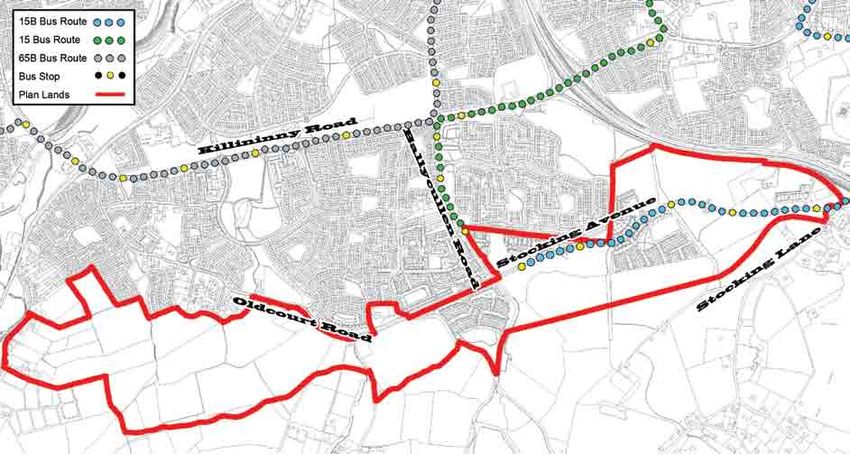
Ballycullen - Oldcourt Draft Local Area Plan																						Introduction

Fig. 1.4 Aerial Photograph of Plan Lands, 2009

           Plan Lands

                                                             Killininny Road

                                                                                                                 M50

                             Allenton                                                 Dalriada   Stocking Wood

                                           Ely   Oldcourt
                                                 Cottages

                                                                               Hunter’s Wood

                Cemetery

                                                                                Orlagh Retreat

 0    125 250              500           750     1,000
                                                    Meters
South Dublin County Council							Development, Economic and Transport Planning Department							October 2013           7
Area Analysis																					Ballycullen - Oldcourt Draft Local Area Plan

2.0 DEVELOPMENT & POPULATION ANALYSIS                                        Photo 2.1 Elevated View of Suburban and Rural Context to Plan Lands   Photo 2.3 Semi-Detached Housing in Stocking Wood
This chapter provides a description of recent developments carried out
within the Plan Lands followed by a development and demographic
analysis.

2.1 Description of Development
The Ballycullen-Oldcourt lands comprise a rural-suburban fringe that
has been partially developed. They largely comprise agricultural lands
under pasture on the western side with elements of medium density
residential development on the eastern side. Agricultural activity is more
intense on the western side.

Residential development within and adjacent to the Plan Lands is
concentrated along the Allenton Road, Oldcourt Road, Hunters Road,
Stocking Avenue and the Ballycullen Road. The location and extent
of development across the Plan Lands creates two distinct areas, the
undeveloped and rural western side and the partially developed and
semi-suburban eastern side.

The agricultural lands on the western side are interspersed with sports
pitches, low density rural housing and small agriculture and business
units. These lands are divided by relatively undisturbed hedgerow and
stream systems.

Residential development on the eastern side of the Plan Lands has taken      Photo 2.2 Urban Style Housing in Hunterswood adjacent to Gunny Hill   Photo 2.4 Apartment & Duplex Blocks in Stocking Well
place on both sides of the Ballycullen Road (Hunterswood and Dalriada)
and intermittently along Stocking Avenue (Stocking Wood, Stocking
Well and Stocking Hill). The mix of development that has taken place
is largely suburban in nature with elements of urban type development
and includes single storey traveller accommodation, 2-3 storey houses,
2-3 storey duplex blocks and 3-4 storey apartment blocks.

Much of the development with the exception of Hunterswood remains
substantially incomplete leaving intermittent greenfield areas between
and around estates that retain some elements of the former rural
landscape. Some sites immediately adjacent to and around the
incomplete developments include left over building materials and are
enclosed with hoarding and railings.

The hedgerow system on the eastern side has been substantially
removed in places and some sections of stream have been culverted,
eroding sections of the natural rural landscape.

8 					South Dublin County Council					                                                               Development, Economic and Transport Planning Department				                          October 2013

Ballycullen - Oldcourt Draft Local Area Plan																					                                                                       Area Analysis

2.2 Ballycullen - Oldcourt Action Area Plan (2000)                            Fig. 2.1 Ballycullen - Oldcourt Action Area Plan (2000)
The Ballycullen – Oldcourt Action Area Plan (2000) related to 76
hectares of lands zoned for residential development under the South
Dublin County Council Development Plan, 1998.

The stated development concept of the Action Area Plan was to ensure
that the lands were developed sympathetically as an extension of
the suburban fringe to the foothills of the mountains, respecting the
elevation and resultant prominence of the lands and the natural amenity
value of the mountains. Within this concept it was intended to develop
a sustainable community where all residents are within convenient
walking distance to schools, parks, and community facilities. It was
also a stated intention that there should be minimal reduction on the
development potential of lands from existing constraints such as water
mains or power lines.

The main components that the Action Area Plan sought to deliver
related to roads, housing, open space, neighbourhood/local facilities
and community facilities, which were planned as follows:
• An east-west distributor road (designed as a street) together with a
    realigned Ballycullen Road.
• Residential development in a mix of dwelling types at net residential
    densities of 30-50 dwellings per hectare giving a potential of a least
    2,300 housing units across the A1 residential zoned lands.
• A mix of dwelling types incorporating apartments, duplex units,
    townhouses and conventional housing with building heights of no
    greater than two storeys except in circumstances where building
    heights would not impinge on the 120 metre contour. Scope for
    three or more storey structures to be considered where prominent
    building frontage is desirable.
• The designation of ‘Class 1’ open space representing 10% of the net
    housing area and two thirds of the development plan requirement
    of 14% with the balance to be provided as ‘incidental environmental
    open space’.
• A road network that would provide good accessibility to the
    Woodstown Village neighbourhood centre and the designation of
    a local centre site where smaller scale facilities could be provided.
• The designation of a centrally located site for a primary school facility
    and a reserved/local centre site to accommodate unanticipated
    uses. A public transport terminus site was also designated for
    reservation off the northern side of Stocking Avenue.

South Dublin County Council							Development, Economic and Transport Planning Department							October 2013                                      9
Area Analysis Ballycullen - Oldcourt Draft Local Area Plan
BALLYROAN
2.3 Development Plan Zoning of Plan Lands Fig. 2.2 Zoning Map of Plan Lands under South Dublin County Council Development Plan, 2010-2016
The Plan Lands, which comprise approximately 125 hectares, are
primarily zoned ‘Objective A1’ (approx. 107 Hectares/ 86%) under the USE ZONING OBJECTIVES Specific Local Objective KNOCKLYON
South Dublin County Council Development Plan, 2010 – 2016. This is
PS To Provide for a Primary School
followed by lands that are zoned ‘Objective F’ (approx. 9 hectares/7%), Objective A TYMONResidential
To protect and/or improve SOUTH Amenity
‘Objective A’ (approx 5 hectares/4%), ‘Objective B’ (approx. 4 To provide for new Residential Comm unities in To protect and preserve Trees and Woodlands
Objective A1
hectares/3%) and ‘Objective LC’ (approx. 1 hectare/0.8%) zoned lands. accordance with approved Area Plans
The extent of lands within each zoning objective and the description of To protect and improve Rural Amenity TA Traveller Accomodation
Objective B and to provide for the development of
each objective are provided in Figure 2.2. Agriculture
Long Term Road
SCHOLLARSTOWN
To preserve and provide for Open Space
Objective F and Recreational Amenities
Plan Lands
A primary school site and traveller accommodation site are designated
Countours
in the eastern area of the Plan lands off Stocking Avenue. Development Objective G To protect and improve High Amenity Areas
Glenasmole / Bohernabreena Study Area
has occurred on the traveller accommodation site. No development has To protect, provide for and/or improve
Objective LC
been realised on the primary school site. Local Centre facilities
BALLYCRAGH
OLDBAWN TA
Part of the undeveloped lands on the western side of the Plan Lands,
off Oldcourt Road, are subject to Specific Local Objective (SLO) no. 87
under the current County Development Plan. The SLO reads as follows:
“a) Access through the existing residential developments of Oldcourt Cottages and Ely Manor KILLININNY PS
BALLYCULLEN
House will not be permitted.
110m
116m
m
b) The proposed access road to serve the development to be located contiguous to the existing
120
development of Oldcourt Cottages.
c) The public open space to serve the scheme to be located to the east of the proposed access 87
road. The public open space must be easily accessible to and must serve as public open space 11
0m NEWTOWN
OLDCOURT
120m
for Oldcourt Cottages. 11
6m
d) In any such development, single storey dwellings only will be permitted in the area of the site(s) 12
0m
facing existing residential development.
e) Protection and preservation of the biodiversity value and significant landscape character of
lands within the Dodder Valley and on the lands at Oldcourt/Kiltipper which are subject to a WOODTOWN
Local Area Plan by means of requiring a landscape assessment to be submitted for development
110m
proposals, including the design and improvement of roads and bridge infrastructure to serve
said lands. The assessments shall take into account existing treelines, significant hedgerows,
landscape features, remediation of negative biodiversity impacts, improved amenity and
BOHERNABREENA
accessibility to the river.
f) That all appropriate road upgrading and improvements in relation to capacity and safety be
completed prior to any further development of the area.”
The Development Plan also includes a long term road proposal for a 0 125 250 500 750 1,000
ORLAGH
Local Road to run between the Oldcourt Road and Bohernabreena Meters
Road and includes a specific objectives to protect and preserve the
FRIARSTOWN UPPER
double ditch hedgerows located either side of Stocking Wood. Further
Development Plan policies and objectives that are relevant to this Local
Area Plan are contained in Appendix 3 of this LAP.
10 South Dublin County Council Development, Economic and Transport Planning Department October 2013Ballycullen - Oldcourt Draft Local Area Plan Area Analysis
2.4 Development Status of Plan Lands Fig. 2.3 Development Status Summary of Plan Lands
As illustrated in Figure 2.3, a large proportion of the Plan Lands remain
undeveloped (approx. 110 ha./80%). These undeveloped lands are Undeveloped No Permissions KNOCKLYON
primarily zoned for residential development (Objective A1 - approx. 90 Undeveloped Permissions
TYMON SOUTH
ha.) with a small element zoned for local centre development (Objective
Developed
LC – approx. 1 hectare). Remaining undeveloped lands are zoned for
agriculture and open space. Approximately 40 hectares of undeveloped
lands that are zoned ‘Objective A1’ are also the subject of extant
permissions that are yet to commence or recommence development. SCHOLLARSTOWN
All of the lands that are subject to extant permissions are located on the
eastern side of the Plan Lands.
2.5 Residential Development and Density
Approximately 1,800 dwellings were permitted on the eastern side BALLYCRAGH Stocking
the Plan Lands between 2000 and 2012 at an average net density of Wood
OLDBAWN Lands
approximately 37 dwellings per hectare. Approximately 640 dwellings
(35%) have been built leaving 1,160 dwellings that have planning
permission but have not commenced construction.
The majority of permitted dwellings that have not commenced construction KILLININNY
s
BALLYCULLEN Lan d
relate to the partially completed Stocking Wood Development and a rtner
ship
n Pa
large residential scheme on adjacent lands to the south that has yet culle
Bally
to commence construction (Ballycullen Partnership Site). The original
permission for the Stocking Wood development is due to expire in
September 2015 and the adjacent Ballycullen Partnership permission NEWTOWN
OLDCOURT
expires in January 2014. Approximately 100 dwellings have been
permitted (under Part 8 permission) around the Stocking Hill Traveller
Accommodation Site.
In terms of dwellings that have been constructed (640), these comprise WOODTOWN
2 bedroom apartments (38%), 3 bedroom houses (35%), 4 bedroom
houses (15%) and 3 bedroom duplexes (12%). Dwellings have been
constructed at an approximate net density of 40 dwellings per hectare.
This includes for the Stocking Wood/Well development, which has been BOHERNABREENA
built at 45 dwellings per hectare. The proportion of apartments and
duplexes equates to approximately 50% of dwellings that have been
built, which is considered to be extensive in the context of their outer
suburban and semi-rural location.
ORLAGH
0 125 250 500 750 1,000
The 1,160 permitted dwellings that are yet to commence largely Meters
comprise 3 bedroom houses (25%), 4 bedroom houses (19%), 2 FRIARSTOWN UPPER
bedroom duplexes (16%), 2 bedroom apartments (15%) and 3 bedroom
duplexes (9%). Other permitted dwelling types include 5 bedroom
that was to form part of the Stocking Wood Development. This centre the Bohernabreena Road and Oldcourt Road. These structures primarily
houses (7%), 4 bedroom duplexes (3%), 2 bedroom houses (2%), 1
was not constructed and its permission expired in October 2011. Its comprise suburban and rural style housing on large garden plots with a
bedroom apartments (1%), 3 bedroom triplexes (1%), 3 bedroom
components were to include crèche (1,400 sq.m), community (310 number of low rise backland light industry/agricultural units. Suburban
apartments (0.5%) and 2 bedroom triplexes (0.5%). These dwellings
sq.m) retail/service (2,000 sq.m) and office (220 sq.m) floorspace. and rural style housing in Ely, Allenton and Oldcourt Cottages are also
would achieve a net density of approximately 36 dwellings per hectare.
low rise and range from between 1 and 2 storeys in height.
The percentage of apartments, duplexes and triplexes as a proportion
Permission was granted in February 2013 by An Bord Pleanála for
of dwellings to be constructed would equate to 47%, which is also
a discount foodstore (1,500 sq.m) that has commenced construction Building heights within the partially developed eastern side of the
considered to be extensive in an outer suburban and semi-rural location.
on the Local Centre zoned site on the northern side of Oldcourt Road Plan Lands include a more diverse variety of residential buildings in
adjacent to Beechdale. The permission included for the reservation of a Hunterswood, Dalriada, Stocking Wood, Stocking Well and Stocking
2.6 Commercial and Community Floorspace
site for 4 no. retail units. Hill. This includes single storey traveller accommodation, 2 and 3 storey
Approximately 5,100 sq.m of commercial and community floorspace
houses, 3 storey duplex blocks and 3 to 4 storey apartment blocks.
was permitted on the eastern side of the Plan Lands as part of the
2.7 Building Heights and Composition
Dalriada and Stocking Wood developments. To date, a crèche (approx.
Building Heights vary across the Plan Lands from low rise to medium Dwellings to the north of the Plan Lands are of a similar height and
280 sq.m) has been constructed.
rise structures with the predominant building height being 2 storeys. The composition with the exception of a seven storey apartment block on
largely undeveloped western area of the Plan Lands accommodates a the northern side of Hunters Road, which is significantly taller than
The majority of the permitted floorspace on the eastern side of the
small number of low rise single and two storey structures along and off surrounding buildings and creates a local landmark.
lands related to a ‘commercial/community centre’ (approx 4,000 sq.m)
South Dublin County Council Development, Economic and Transport Planning Department October 2013 11Area Analysis Ballycullen - Oldcourt Draft Local Area Plan
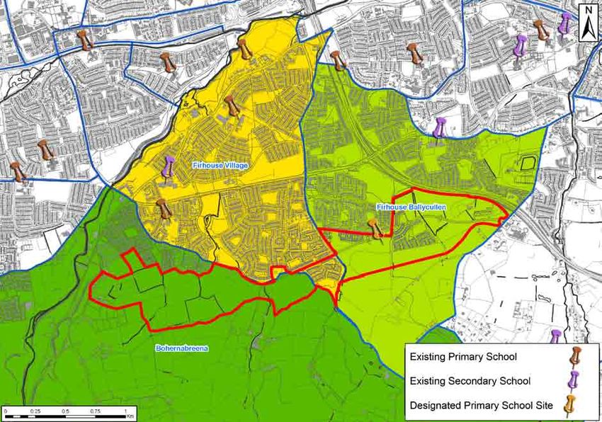
2.8 Population and Housing Statistics Fig. 2.4 Schools and District Electoral Divisions
According to Central Statistic Office (CSO) Census data, the population
within the administrative boundary of South Dublin County Council grew
by 7.4% from 246,935 in 2006 to 265,205 in 2011. The age profile of
the County in 2011 indicated a relatively young population with the pre-
school and school going age cohorts from 0 - 18 accounting for 28% of
the population and the 25 – 44 age cohort accounting for 33% of the
population. Those aged 65 plus accounted for 8.7% of the County’s
population. The housing stock in the County grew by 11.2% from
87,484 dwellings in 2006 to 97,298 dwellings in 2011 with the respective
vacancy rates dropping from 6.2% to 5.4%.
As illustrated in Figure 2.4 opposite, the Plan Lands straddle three
different District Electoral Divisions namely Firhouse Village, Firhouse
Ballycullen and Bohernabreena. All three divisions grew in population
between 2006 and 2011. Firhouse Ballycullen experienced the highest
population growth population growth at 17.6% (from 6,610 – 7,773
people), followed by Firhouse Village at 8.3% (10,751 – 11,648 people)
and Bohernabreena at 7.5% (4,272 – 4,592). The combined age profile
of all three District Electoral Divisions also indicated a relatively youthful
population that was similar to the County with a slightly lower proportion
of people aged 65 plus at 5% of the population.
All three electoral divisions also experienced an increase in housing
stock between 2006 and 2011 with Firhouse Ballycullen accounting for
the highest increase at 25.6% (2,115 dwellings - 2,657), followed by
Firhouse Village at 4.9% (3,851 dwellings – 4,039) and Bohernabreena
at 3.8% (1,436 dwellings – 1,491). Vacancy rates in 2011 ranged from
7.2% in Firhouse Ballycullen, 6% in Bohernabreena and 5% in Firhouse
Village.
The CSO Small Area Population Statistics data recorded a local
population of approximately 1,300 people within the Plan Lands in 2011.
This includes Stocking Wood, Stocking Well, Stocking Hill, Dalriada and
the southern section of the Hunterswood Development. The proportion
of people in the 0-18 age cohort was recorded at 29%, which was
similar to that for the County. The proportion of people in the 25 – 44 age
cohort (60%) was almost double that of the County average, indicating a
much younger age profile in terms of adult population. Only 1.7% of the
population within the Plan Lands was 65 or over.
Of the 634 dwellings that were recorded by the CSO within the Plan
Lands, 103 (16%) were found to be unoccupied, which was significantly
higher than the County average. In terms of housing tenure, 74% of in Firhouse (Firhouse Community College) and Knocklyon (Saint Research carried out jointly between South Dublin County Council and
dwellings were owner occupied with the remainder (26%) under rental Colmcille’s Community School). the Department of Education and Skills indicates that almost half of
occupancy and an even split (50:50) between public and private rented children of primary school going age in Firhouse and Oldcourt/Allenton
accommodation. This compares to a similar owner occupied rate of 2.9.1 Primary School Enrolments attend primary schools outside of the area.
roughly 70% for the County with roughly 30% rented. A slightly higher The number of pupils enrolled in Scoil Treasa and Scoil Carmel Junior
proportion of rental accommodation across the County was privately and Senior schools increased from 865 pupils in 2002 to 867 pupils in 2.9.2 Secondary School Enrolments
rented at 60%. 2005 before declining by 5% to 823 pupils in 2012. The number of pupils enrolled in Firhouse Community College between
2002 and 2012 fluctuated slightly with a low of 561 pupils in 2008 and a
2.9 Schools The number of pupils enrolled in Holy Rosary Primary school has high of 664 in 2012. The number of pupils enrolled in Saint Colmcille’s
The South Dublin County Council Development Plan 2010 – 2016 steadily increased year on year between 2002 and 2012 from 316 Community School, which opened in 2000, has increased year on year
designates a primary school site on the Plan Lands on the southern pupils in 2002 to 585 in 2012 representing an increase of 85% over during the same period from 376 pupils in 2002 to 720 pupils in 2012.
side of Stocking Avenue and to the west of Stocking Wood. a 10 year period. The provision of temporary accommodation on the
school grounds preceded the increase in pupil enrolment numbers. A
Three nearby local primary schools are located in Firhouse (Scoil permanent school extension is currently under construction.
Carmel Junior School and Scoil Treasa Senior School) and Oldcourt/
Allenton (Holy Rosary). The nearest Secondary Schools are located
12 South Dublin County Council Development, Economic and Transport Planning Department October 2013Ballycullen - Oldcourt Draft Local Area Plan Area Analysis 2.10 Movement Fig. 2.5 Public Transport Routes Map 2.10.1 Public Transport The Plan Lands are located approximately 10 kilometres by road to Dublin City Centre. At their nearest point (Oldcourt Road), the lands are also located approximately 3 kilometres by road to Tallaght Town Centre and the Red Luas Line Terminus. At their furthest point (Stocking Avenue), the Plan Lands are located approximately 6 kilometres from Tallaght. The Red Luas Line terminus in Tallaght offers a high frequency public transport service to and from Dublin City Centre and Citywest Business Campus. The terminus is not considered to be within convenient walking distance of the Plan Lands especially the eastern areas, but is considered to be within cycling distance. The eastern areas of the Plan Lands are served by relatively high frequency bus services in the form of the 15 and 15b bus routes, which were introduced to the area in 2011. These bus routes serve Dublin City Centre at a combined peak time rate of approximately 9 buses per hour and terminate on Ballycullen Road and Stocking Avenue. The western areas of the Plan Lands are not directly served by public transport. A small proportion of these lands are within walking distance of the 15 and 15b bus services. A further small proportion are within walking distance of the low frequency 65b bus service, which operates between Citywest Business Campus and Dublin City Centre via Killininny Road at a peak time rate of approximately 0.5 buses per hour. There is therefore a significant disparity in the quality and accessibility of public transport services between the eastern and western areas of the Plan Lands. According to the Small Area Population data from the 2011 CSO census, 17.4% of the local population within the Plan Lands commuted by public transport, on foot or by bicycle. This compares to a rate of 34% that was recorded for the County under the same Census. It is noted, however, that the Census was recorded in April 2011 prior to the routing of the 15 and 15b buses through and near the eastern area of the Plan Lands. South Dublin County Council Development, Economic and Transport Planning Department October 2013 13
Area Analysis																					Ballycullen - Oldcourt Draft Local Area Plan

2.10.2 Pedestrian and Cycle Movement                                         Photo 2.5 Barriers to Pedestrian Movement - Stocking Avenue    Photo 2.7 Barrier Between Stocking Well & Zoned Open Space
Pedestrian and cyclist movement is limited throughout the Plan
Lands. This includes the areas that have been developed and partially
developed.

Primary roads such as Ballycullen Road, Hunters Road, Stocking Avenue
and Oldcourt Road have relatively straight and wide alignments with
high traffic speeds and an absence of pedestrian and cycle crossings.
The M50 motorway also creates a significant barrier to movement to the
north and north-east on the eastern side of the Plan Lands.

There are significant gaps between pedestrian and cyclist access points
to housing developments along the Oldcourt Road and Hunters Road
where continuous railings form barriers to movement. Similar railings
have also been erected along Stocking Avenue, including site frontages
that are yet to be developed, thus limiting pedestrian and cyclist
movement to and from existing and future housing developments.
These barriers also limit accessibility to bus stops that serve the high
frequency bus services along Stocking Avenue and Ballycullen Road.

The layouts of new housing estates within and adjacent to the Plan
Lands are largely cellular with cul-de-sacs that prevent movement
between estates, thus creating disjointed networks of pedestrian routes.
This includes the Stocking Well, Woodstown and Dalriada housing
developments.                                                                Photo 2.6 Barriers to Pedestrian Movement - Ballycullen Road   Photo 2.8 M50 Motorway Barrier to Knocklyon Park

Disjointed sections of off-street cycle lane that give right of way to
vehicles at junctions are provided along Stocking Avenue, Ballycullen
Road, Hunters Road and the realigned section of the Oldcourt Road.
There are no dedicated cycle routes through or between estates.

2.10.3 Primary Vehicular Access and Movement
The area of the Plan Lands benefits from its nearby location to the M50
motorway in terms of access to the national road network. The proximity
to the motorway also creates traffic and noise issues.

The lands are located beyond the southern fringe of the Killininny
Road, which serves as a strategic access road between Tallaght,
Bohernabreena and the M50. Roads within and adjacent to the Plan
Lands including the Oldcourt Road and Ballycullen Road converge on
Killininny Road and depend on this road for access to the M50 motorway
and towards major employment centres to the north and west including
Dublin City Centre, Tallaght and Citywest.

The Killininny Road has busy junctions at either end where other roads
converge at Old Bawn Bridge to the west and the M50 slip roads/
overpass to the east. Traffic attempting to move northwards from the
Plan Lands especially at peak morning times tends to encounter slow
moving and heavy traffic with the only points of relief being the indirect
routes of Gunny Hill towards the Dublin Mountains to the south and
Stocking Lane towards Ballyboden to the east. Traffic problems are
exacerbated by the cellular layout of housing estates.

Available road collision data for the area (1996 – 2008) indicates that
one serious collision involving two vehicles occurred at the upper end
of the Ballycullen Road in January 1996 and a fatal collision occurred in
January 2007 near Stocking Lane, which involved one vehicle.

14					South Dublin County Council					                                                               Development, Economic and Transport Planning Department				                  October 2013
Ballycullen - Oldcourt Draft Local Area Plan																					                                                                                                                                                           Area Analysis

2.11 Utilities                                                                       Fig. 2.6 Utilities: High Voltage Overhead Electrical Lines, Large Diameter Watermains & Gas Mains
As illustrated in Figure 2.6, the Plan Lands are traversed by a number
of important utility lines including watermains, gasmains and overhead                        220 KV                                                                                  KNOCKLYON
electrical transmission lines.                                                                110 KV
                                                                                                                 TYMON SOUTH
                                                                                              Plan Lands
A 12” diameter Dublin City Council watermain and a 15” diameter Dublin
City Council watermain both run parallel to each other through the                            Gas Main
majority of the Plan Lands along a north-east south-west axis. These                          Watermains
watermains following part of the route of the Oldcourt Road, Hunters                                                                                                                                        SCHOLLARSTOWN

Road and Stocking Avenue. Dublin City Council requires a minimum
reservation of 5 metres to the north of the 15” watermain and 5 metres
to south of the 12” watermain plus the distance between the parallel
watermains i.e. a corridor of 10 metres + X metres.
                                                                                                                                               BALLYCRAGH
The western area of the Plan Lands is partially traversed by 220kV
                                                                           OLDBAWN
overhead transmission lines. ESB requires a minimum lateral clearance
of 30 metres on either side of the centre line of these high voltage
transmission lines. The 110kV lines that traverse the eastern section of
the Plan Lands require a minimum lateral clearance of 23 metres from
the centre line on either side.                                                                                       KILLININNY
                                                                                                                                                                                  BALLYCULLEN

A large gas main also follows the Route of the Oldcourt Road, Hunters
Road and Stocking Avenue.

                                                                                                                                                                                                                                NEWTOWN
                                                                                                                                                            OLDCOURT

                                                                                                                                                                                                  WOODTOWN

                                                                                                                                           BOHERNABREENA

                                                                                                                                                                                                   ORLAGH
                                                                                       0 125 250           500      750        1,000
                                                                                                                                  Meters
                                                                                                                      FRIARSTOWN UPPER

South Dublin County Council							Development, Economic and Transport Planning Department							October 2013                                                                                                                              15
You can also read