Ballinasloe Draft Local Area Plan 2015-2021 - April 2015 - Galway County ...
←
→
Page content transcription
If your browser does not render page correctly, please read the page content below
Ballinasloe Draft Local Area Plan
            2015-2021
                                        April 2015

                 Forward Planning
                Galway County Council
                  Áras an Chontae
                    Prospect Hill
                       Galway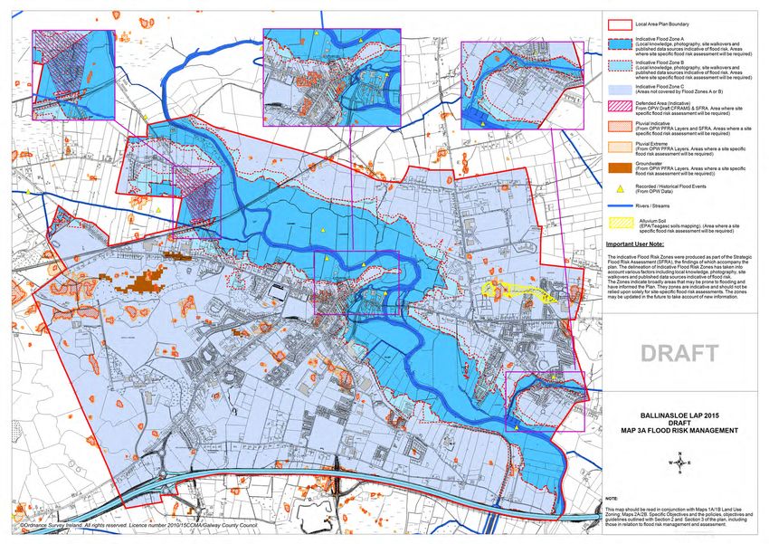
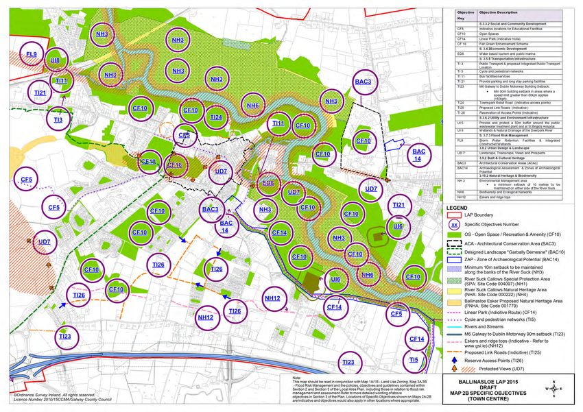
Table of Contents
                                                                                                                                                 Page

1.    Introduction .................................................................................................................................... 3

1.1     Preamble ....................................................................................................................................... 3
1.2     Profile of Ballinasloe ...................................................................................................................... 3
1.3     Local Area Plan ............................................................................................................................. 5
1.4     Plan Structure ................................................................................................................................ 6
1.1     Preamble ....................................................................................................................................... 6
1.2     Profile of Ballinasloe ...................................................................................................................... 6
1.3     Local Area Plan ............................................................................................................................. 6
1.5     Plan Structure ................................................................................................................................ 6
1.5     Plan Informants and Considerations ............................................................................................. 7

2.    Strategic Vision and Development Strategy ............................................................................. 10

2.1     Strategic Vision ........................................................................................................................... 10
2.2     Development Strategy ................................................................................................................. 11

3.    Development Policies, Objectives and Guidelines ................................................................... 19

3.1     Land Use Management ............................................................................................................... 19
3.2     Residential Development ............................................................................................................ 27
3.3     Social and Community Development .......................................................................................... 30
3.4     Economic Development .............................................................................................................. 33
3.5     Transportation Infrastructure ....................................................................................................... 38
3.6     Utilities Infrastructure, Energy Infrastructure, Renewable Energy & Telecommunications ........ 45
3.7     Climate Change and Flooding ..................................................................................................... 52
3.8     Urban Design and Landscape ..................................................................................................... 61
3.9     Built Heritage & Cultural Heritage ............................................................................................... 63
3.10 Natural Heritage & Biodiversity ................................................................................................... 69

4.    Local Area Plan Maps .................................................................................................................. 74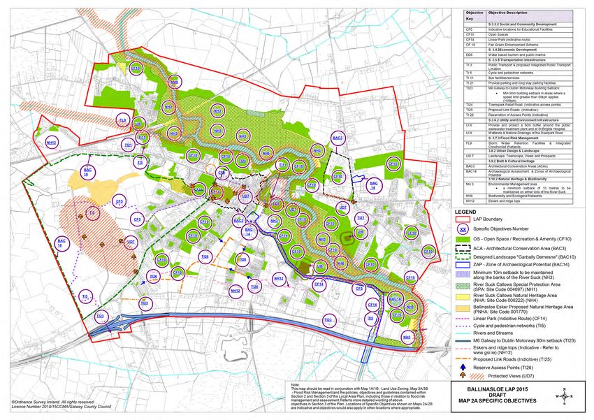
1. Introduction

1.1 Preamble
The Ballinasloe Local Area Plan is a land use plan and overall strategy for the development of
Ballinasloe over the period 2015-2021. The plan shall have effect from the date of adoption by the
elected members of Galway County Council and shall cease to have effect at the expiration of 6 years
from that date, unless the plan period is extended by resolution in accordance with Section 12 (d) to (f)
of the Planning and Development (Amendment) Act 2010. The successful implementation of the Plan
will have a positive impact on Ballinasloe, ensuring that it develops in a sustainable manner and
complements the implementation of the current Galway County Development Plan.

1.2 Profile of Ballinasloe
Ballinasloe occupies a strategic location adjacent to the M6 National Primary route linking Dublin and
Galway and is one of the principle ‘Gateways to the West’. In addition the town has daily public
transport services (both rail and bus) to Galway, Athlone and Dublin. Ballinasloe is also located on the
eastern aspect of one of the County’s Strategic Development Corridors which are marked for co-
ordinated and appropriate development (refer to the Core Strategy Map of the current Galway County
Development Plan).The recently constructed public marina and associated developments along the
River Suck, now make it possible for cruisers to venture from the Shannon and berth in Ballinasloe.
The town also benefits from key energy and telecommunications infrastructure which are considered
key for the location of industrial/technological companies. Ballinasloe is connected to the Bord Gáis
gas pipeline network, to ENet and BT fibre network which run through the town centre and main
roadways and which service the commercial, business and enterprise base of the town.
Ballinasloe has an important sub-regional role regarding retail provision, employment and community
facilities in particular education and healthcare. An important part of the town’s social events calendar
is the annual October Horse Fair which contributes significantly to the local economy. Distinct natural
amenities, particularly the River Suck also have important economic benefits for the town.

                                             © Ordnance Survey Ireland. All rights reserved. Licence
                                                number 2010/15CCMA/Galway County Council.

         Location of Ballinasloe Plan Area

Ballinasloe owes its origins to its location as a crossing point on the River Suck, a tributary of the
Shannon, on the borders of Counties Galway and Roscommon and derives its name from the ford on
the River Suck, Béal Átha na Sluaighe. The River Suck played a main role in the development of the
town, with the first significant development in the form of a Norman castle constructed on its western

                                                                                                       Page 3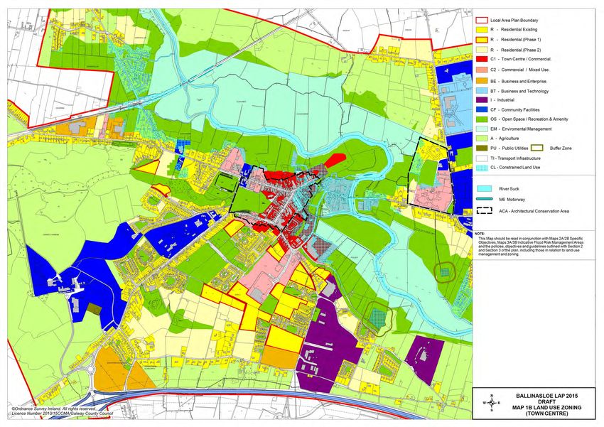
banks, the remains of which still survive just off Bridge Street. Development before the eighteenth
century was generally confined to the eastern bank of the river.

Ballinasloe’s built environment has the appearance of a planned, well laid out town. The present day
town centre results from the intervention of the local landlords, namely the Trench family. Under their
direction, firstly Main Street and then Brackernagh on the outskirts of the town were developed in the
1790s. The Trench family also laid down Garbally Estate, the Fair Green and many of the town’s
                                                                                      th
substantial buildings, including the Parochial Hall and the Town Hall. In the early 19 Century, Society
and Dunlo Streets were laid out in the new town centre, expanding it westward from the river towards
the area now known as Townparks. The expansion of the Grand Canal to the town in 1828 assisted
the expansion of the corn trade and effectively opened up Ballinasloe as a market town to the wider
hinterland and the rest of the country. Accessibility was further enhanced by the arrival of the railway
in 1851. The October Fair was established during this prosperous time and still remains one of the
most important social and economic events in the life of the town.

The existing land uses in the town highlight some important elements to the town structure. Large
areas of the town are currently in public institutional use, which have an impact on and influence the
town’s form and development. Notably in this regard are the significant parcels of land in the
ownership of the Health Service Executive, such as the former St. Brigid's Hospital to the east of the
River Suck and Portiuncla Hospital to the south west of the town centre.

The town has a tight commercial core, the main primary streets are concentrated along Dunlo Street,
Market Square, Society Street and Main Street, secondary streets include Bridge Street, Jubilee
Street, Marina Point, Riverside Court and Riverview, and third tier streets include Dunlo Hill, Church
Hill, Davitt's Place, Society Court, Emmet Place, Hopson Lane & Bolger’s Lane. The commercial
developments around the town are small scale local neighbourhood type shops, consisting mainly of
comparison goods and the town centre is adequately served in terms of medical/recreational services,
restaurants/cafes/takeaways, hairdressers/barbers, pubs and discount stores. The area identified as
town centre does not extend to encompass the large and expansive new retail complex that is
occupied by Tesco and Aldi at Dunlo. There is also a supermarket at Brackernagh located
approximately a kilometre outside of the retail core and serves more as a neighbourhood centre for
the wider Brackernagh area while also complementing Portiuncula Hospital, which is located across
the road from it.

The town provides higher order important services such as Portiuncula Hospital, one of the largest
general and maternity hospitals within the country. The town is well serviced with educational facilities
and spare capacity exists in both primary and second level schools. Proximity to Athlone and Galway
City for third level facilities is also a major advantage.

Significant tourist attractions include the Ballinasloe Horse Fair which is one of Europe’s oldest and
largest Horse Fairs and takes place annually in October on the Fair Green, Ballinasloe Golf Course,
GAA pitch, running tracks and sports grounds. Marine tourism continues to be a growing sector and
on-going works to make the River Suck navigable have resulted in the linking of Ballinasloe to the
Shannon/Erne Waterway. A 25 berth public marina has been completed by Duchas at Slí na hAbhainn
and a private marina at Portnick has berthing facilities for 35 pleasure craft with permanent and winter
moorings. Ballinasloe has also traditionally proved popular with anglers, particularly those interested in
coarse angling along the River Suck. Shooting holidays also attract many repeat tourists.

Ballinasloe hosts a range of industrial/enterprise ventures that are operated by both national and
international companies. The industrial developments are located on the outskirts of the town, to the
south, and southeast. The main enterprise areas are located in the IDA Business and Technology
Park and the Ballinasloe Enterprise and Technology Centre which are situated to the northeast of the
town centre along the R357.

The residential growth experienced within Ballinasloe in recent years has further strengthened the
economic base of the town. The majority of residential development is located outside the town core
on the arterial routes out of the town. Housing estates or developments are generally small to medium
in size. These are not confined to any particular area of the town, though Creagh and
Glentaun/Kilgarve areas display a significant concentration of residential development east of the
River Suck. There are also considerable backland areas to the rear of the main streets and which offer

                                                                                                  Page 4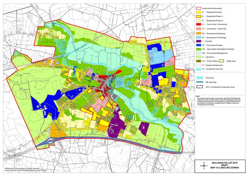
considerable potential for future development including access but this must take place in a planned
and integrated manner so as to maintain the town’s character.

Areas of ecological and environmental sensitivity have remained undeveloped, specifically areas
along by the River Suck which flows in a southerly direction through the town and its environs. The
River Suck Callows is designated as a Special Protection Area (River Suck Callows SPA Site Code:
004097) and forms part of the pan European Network of designated sites. The River Suck is also
designated as a Natural Heritage Area (River Suck Callows NHA Site Code: 000222) as well as part of
Garbally Demesne which is a proposed Natural Heritage Area (Ballinasloe Esker pNHA Site Code:
001779).

In terms of population trends, according to the most recent 2011 CSO figures, the total population of
Ballinasloe (urban and environs) was recorded as 6,577 persons (6449 urban and 128 environs), a
total change in population of 419 persons or a 6.8% increase on the 2006 population level. It is
recognised that the growth targets as set out in the Regional Planning Guidelines and the Core
Strategy of the current County Development Plan are ambitious in the current economic climate.

The Local Area Plans – Guidelines for Planning Authorities (2013) requires every Local Area Plan to
contain a statement that clearly places the area in question within the settlement structure as
established by the relevant development plan. In this regard, Ballinasloe has been identified as the
‘County Town’, in the Core Strategy of the current Galway County Development Plan and the town is
described as playing an important role in particular for East Galway and in the delivery of Local
Government services. The County Development Plan commits to the continuation and enhancement
of the delivery of these services within the town into the future.
A key component of the Ballinasloe Local Area Plan is to ensure that it aligns with the Core
Strategy/Settlement Strategy in the current Galway County Development Plan. The 2011 variation of
the Ballinasloe Development Plan (2009-2015) had assigned 35.53Ha (which included 50% over-
zoning) of undeveloped Residential Phase 1 zoned land. There is no requirement to include any
additional land in order to align this new Plan with the current County Development Plan’s Core
Strategy zoning requirement (35.81Ha). In achieving this allocation, a variety of options with regard to
the existing zoning can be examined through the plan process including phasing development, re-
zoning, and de-zoning. It is important that future development for anticipated growth is plan led so that
Ballinasloe can enhance its vibrancy and grow in a sustainable manner.

1.3 Local Area Plan
1.3.1 Background to the Local Area Plan
This Local Area Plan (LAP) has been prepared by Galway County Council (GCC) to provide a
statutory framework for the future growth, development and improvement of Ballinasloe that is
consistent with the policies and objectives contained in the current Galway County Development Plan
(GCDP) including its Core Strategy/Settlement Strategy and which addresses the needs and
requirements of the local community, service providers and other stakeholders. The purpose of the
Local Area Plan is to guide future development within the town of Ballinasloe, in a sustainable and
equitable manner and to inform members of the public, the local community, stakeholders and
developers regarding policies and objectives for the development of the town, including provisions in
relation to land use management, community facilities and amenities, transport and infrastructure,
urban design, heritage and the environment.
This plan shall have effect from the date of adoption by the Members of Galway County Council and
shall cease to have effect at the expiration of 6 years from that date, unless the timeframe is extended
by resolution in accordance with Section 12 (d) to (f) of the Planning and Development (Amendment)
Act 2010. The plan area for Ballinasloe is comprised of the town and its immediate environs and is
considered to provide an appropriate development envelope for the anticipated growth of Ballinasloe
for the plan period.

                                                                                                 Page 5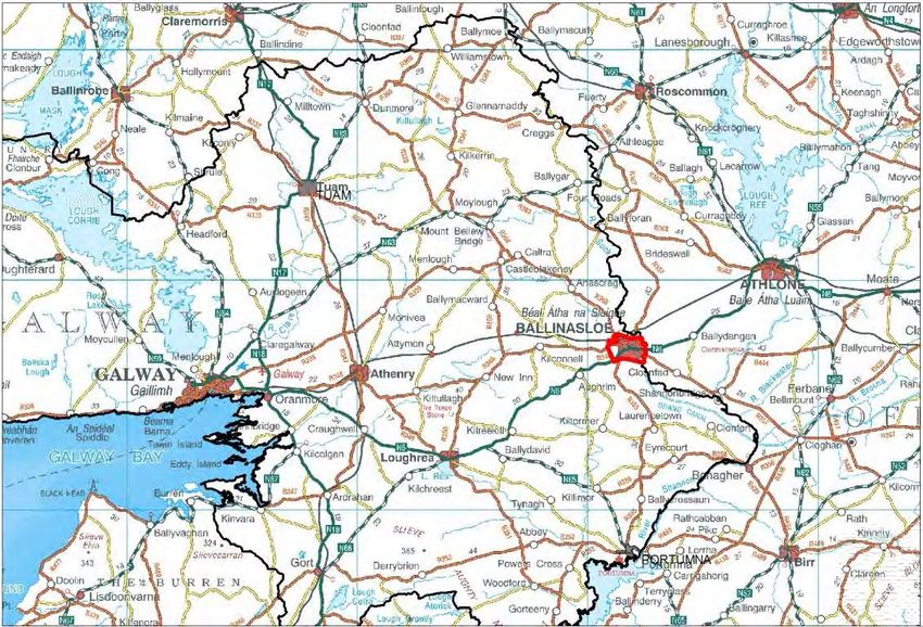
1.3.2 Statutory Process
A Local Area Plan is prepared under the provisions of Sections 18, 19 & 20 of the Planning &
Development Act 2000 as amended. A Local Area Plan is statutorily required to be consistent with the
objectives of the current Galway County Development Plan and consists of a written statement and
plans which may include objectives for the zoning of land in accordance with the proper planning and
sustainable development of the area. The legislation also requires the provision of detail on
community facilities, amenities and detail on standards for the design of developments and structures.

Environmental assessments have also been undertaken to assess the potential impacts of the Local
Area Plan on the environment, including an Environmental Report (SEA/ER) and a Stage 2
Appropriate Assessment (AA/NIR). The Environmental Report (ER) has been prepared in accordance
with the EU Directive on SEA (2001/42/EC), the national Strategic Environmental Assessment
Regulations (SI No. 436 of 2004), (SI No. 200 of 2011), the 2004 Strategic Environmental Assessment
Guidelines Implementation of the SEA Directive (2001/42/EC): Assessment of the Effects of Certain
Plans and Programmes on the Environment issued by the Department of Environment, Heritage and
Local Government (DoEHLG) and regard has also being given to Circular PSSP 6/2011 ‘Further
Transposition of the EU Directive 2001/42/EC on Strategic Environmental Assessment (SEA). An
Environmental Report (ER) is required as part of the plan making process to assess the likely
significant adverse effects on the environment of implementing the Local Area Plan, before a decision
is made to adopt it.

A Habitats Directive Assessment (also referred to as an ‘Appropriate Assessment’ or ‘AA’) has been
prepared in accordance with Article 6(3) of the EU Habitats Directive (92/43/EEC), European
Communities (Birds and Natural Habitats) Regulations 2011, the Appropriate Assessment of Plans
and Projects in Ireland-Guidance for Planning Authorities 2010 issued by the Department of
Environment, Heritage and Local Government and the Planning and Development Act 2000, (as
amended). An Appropriate Assessment is an assessment of the implications of the plan or project,
alone and/or in combination with other plans and projects, on the integrity of a Natura 2000 Site, in
view of its conservation objectives.

A Strategic Flood Risk Assessment has been prepared for County Galway, which broadly considers
the flood risk issues relevant to the plan area. The Strategic Flood Risk Assessment has been
prepared in accordance with the EU Floods Directive (2007/60/EC), the national European
Communities (Assessment and Management of Flood Risks) Regulations 2010 (SI No. 122 of 2010),
the Planning System and Flood Risk Management Guidelines for Planning Authorities 2009 issued by
the DoEHLG as updated by the Departmental Circular PL 2/2014 and identifies broad flood risk areas
within Ballinasloe LAP area. A Stage 2 Strategic Flood Risk Assessment has also been undertaken for
the plan area which has identified flood zones and areas deemed to be at risk of flooding. The relevant
flood risk data, recommendations and mitigation measures from the Stage 2 Strategic Flood Risk
Assessment (SFRA) have been incorporated into the Local Area Plan, as appropriate.

1.4 Plan Structure
This Local Area Plan has been structured into 4 main sections with separate supporting documents:
                 Introduction
                 1.1 Preamble
                 1.2 Profile of Ballinasloe
 Section 1
                 1.3 Local Area Plan
                 1.4 Plan Structure
                 1.5 Plan Informants and Considerations

                 Strategic Vision and Development Strategy
 Section 2       2.1 Strategic Vision
                 2.2 Development Strategy

                 Development Policies, Objectives and Guidelines
 Section 3       3.1 Land Use Management
                 3.2 Residential Development

                                                                                               Page 6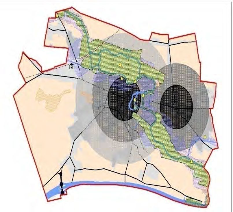
3.3 Social and Community Development
3.4 Economic Development
3.5 Transportation Infrastructure
3.6 Utility Infrastructure, Telecommunications and Energy Infrastructure
3.7 Climate Change & Flooding
3.8 Urban Design and Landscape
3.9 Built Heritage and Cultural Heritage
3.10 Natural Heritage and Biodiversity
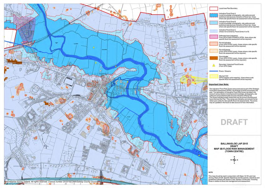
Local Area Plan Maps
Map 1A & 1B – Land Use Zoning
Section 4
Map 2A & 2B – Specific Objectives
Map 3A & 3B – Flood Risk Management
Supporting documents include a Stage 2 Appropriate Assessment (AA/NIR), an Environmental Report
(SEA/ER) and a Stage 2 Strategic Flood Risk Assessment (SFRA) for the LAP area, which are
available as separate documents to the Ballinasloe Local Area Plan.
1.5 Plan Informants and Considerations
1.5.1 Plan Informants
The preparation of the Ballinasloe Local Area Plan has been informed by a wide range of inputs,
including the following:
Issues raised by the local community and other stakeholders through the
Public Consultation publication of a background Issues Leaflet and Issues Paper, draft public
consultation and written submissions.
All relevant Irish and European planning and environmental legislation, in
particular the Planning and Development Act 2000 (as amended), the
Planning and Development Regulations 2001 (as amended); National
Monuments Act 1930-2004 and Wildlife Acts 1976-2000; the national
Climate Action and Low Carbon Development Bill 2015 (including the
Bill’s enactment), EU Directives including the Birds Directive
Legislative Context (2009/147/EEC), Habitats Directive (92/43/EEC), Water Framework
Directive (2000/60/EC), SEA Directive (2001/42/EC), Floods Directive
(2007/60/EC), EU Directive 2014/52/EU which amends Directive
2011/92/EU on the Assessment of the Effects of Certain Public and
Private Projects on the Environment (EIA) and all associated regulations,
Regulation (EU) No. 1143/2014 on the Prevention and Management of
the Introduction and Spread of Invasive Alien Species.
National and regional policy documents and guidelines, in particular: Our
Sustainable Future – A Framework for Sustainable Development for
Ireland (2012); the National Development Plan 2007-2013 as superseded
by the Department of Public Expenditure and Reform document entitled
Infrastructure and Capital Investment 2012-2016, the National Spatial
Strategy 2002-2022, the Regional Planning Guidelines for the West
Region 2010-2022, the National Climate Change Strategy 2007-2012 and
Strategic Planning
follow on document National Climate Change Adaptation Framework
Context
Building Resilience to Climate Change 2012, the Retail Planning
Guidelines 2012, Smarter Travel - A Sustainable Transport Future 2009-
2020, and a range of guidelines including Local Area Plan Guidelines
(2013), SEA Guidelines 2004, Sustainable Residential Development in
Urban Areas Guidelines 2009, Spatial Planning and National Roads-
Guidelines for Planning Authorities (2012), the Design Manual for Urban
Roads and Streets 2013, The Planning System and Flood Risk
Page 7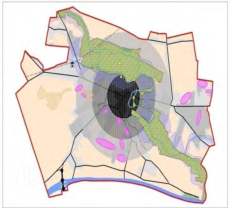
Management Guidelines for Planning Authorities 2009 & Departmental
                           Circular PL2/2014, Implementation of SEA Directive: Assessment of the
                           Effects of Certain Plans and Programmes on the Environment Guidelines
                           2004, and the Appropriate

                           Assessment of Plans and Projects in Ireland-Guidance for Planning
                           Authorities, 2010. The DAHG document titled, ‘Framework and Principles
                           for the Protection of the Archaeological Heritage’ 1999.

                           Statutory plans, in particular: the current Ballinasloe Development Plan
  Statutory Planning       2009-2015 and the need for compliance and consistency with the current
       Context             Galway County Development Plan and the Regional Planning Guidelines
                           for the West Region 2010-2022

                           Local plans, strategies and studies, including: the Biodiversity Action Plan
                           for County Galway 2008-2013; the Galway County Heritage Plan 2010-
                           2016; Galway Transportation and Planning Study 2002; Developing
    Local Planning
                           Sustainable Tourism in Galway: A Framework for Action 2003-2012;
       Context
                           Water-Based Tourism – A Strategic Vision for Galway 2002; and Working
                           Together: Shaping Our Future: Galway County Strategy for Economic,
                           Social and Cultural Development 2002-2012.

                           Assessment of potential environmental impacts of the Local Area Plan,
                           including an Environmental Report (SEA/ER), Appropriate Assessment
    Environmental
                           (AA/NIR), the Strategic Flood Risk Assessment for County Galway and
     Assessment
                           including a Stage 2 Strategic Flood Risk Assessment for the Ballinasloe
                           LAP.

1.5.2 Plan Issues, Considerations & Challenges
The proper planning and sustainable development of Ballinasloe encompasses a broad range of
issues, considerations and challenges, many of which have been highlighted though the plan’s
consultation process. The plan seeks to balance the wide ranging, and sometimes competing, needs
of the local community, businesses, landowners and the environment along with promoting the role of
Ballinasloe as a ‘County Town’ within County Galway, as established in the current Galway County
Development Plan.

The following are a number of the plan’s key issues, considerations and challenges:
   • Common Vision – A common strategic vision needs to be developed that provides a positive
         framework for future growth, consolidation and enhancement of Ballinasloe in accordance with
         the principles of proper planning and sustainable development.

    •   Adherence to the Core Strategy – The Core Strategy in the current Galway County
        Development Plan has identified a target population growth of up to 1,540 additional persons,
        corresponding to 477 additional housing units, up to the year 2021, the timeframe for the
        validity of the current County Development Plan. This target population results in a
        requirement for 35.81ha of zoned land for residential purposes (based on 50% over-zoning).
        A key factor in the preparation of the plan has been the determination of the best locations for
        residential land uses within the town to accommodate this future growth and to ensure
        residential development takes place in an orderly and sequential manner in accordance with
        the Core Strategy.

    •   Population Growth – Ballinasloe has experienced a 6.8% increase in population growth over
        the last two Census periods (2006 & 2011: total change in population of 419 persons or a
        6.8% increase on the 2006 population level). Ensuring appropriate, sustainable settlement
        patterns, including the provision of the necessary planning framework to accommodate
        educational, community, leisure and recreational facilities to satisfactorily match the level of
        population growth, is a key issue in planning for the future.

                                                                                                Page 8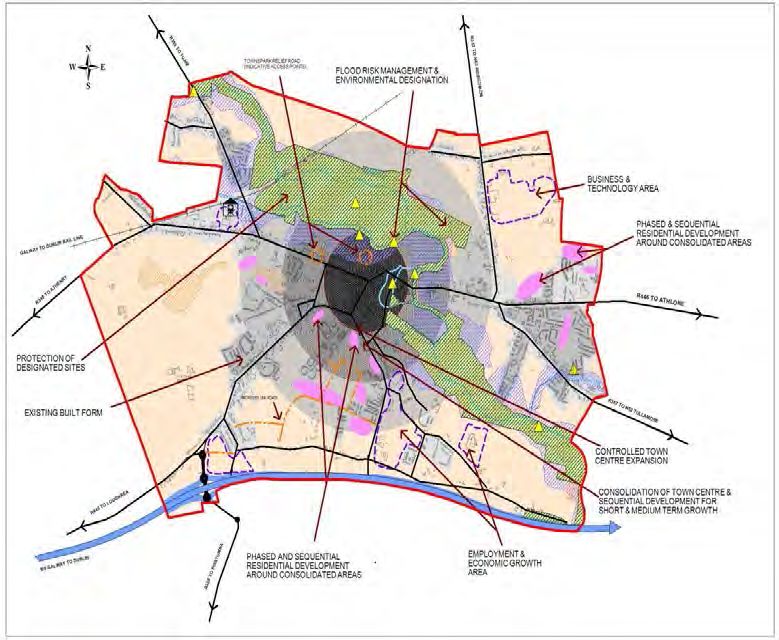
•   Strategic Location and Role – Ballinasloe’s strategic location within the County, on the
    eastern approach to the Galway Gateway with its air and sea transportation routes, its location
    at the junction of major road transport routes (including the M6, M18 and the N18), the Dublin
    – Galway rail corridor, energy and telecommunications infrastructure and with the benefit of a
    high level of self-sufficiency and historic built heritage, provides a basis for the future growth of
    the area and harnessing the strategic role of the town into the future.

•   Economic Activity – Ensuring the enhancement of Ballinasloe’s role as one of the primary
    centres for industry, technology and business/commerce in the east of the County through
    maximising any opportunities presented by the town’s location within one of the Strategic
    Development Corridor’s identified in the Galway County Development Plan. This also includes
    the promotion and maintenance of small and medium scale businesses to protect the vitality
    and vibrancy of the town centre and local neighbourhoods while ensuring that Ballinasloe
    remains an attractive place to work, live, visit and do business.

•   Infrastructure and Transportation – Working towards ensuring that infrastructure is
    developed (particularly the Townparks Relief Road and the completion of the Link Road from
    Beechlawn Road to the Town Centre at Harbour Road and another link road from Beechlawn
    to Pollboy) on an ongoing basis to service future developments so as to accommodate
    planned population growth, whilst ensuring compliance with statutory obligations such as
    those to achieve good water quality status under the EU Water Framework Directive and
    associated national legislation. Addressing deficiencies in the existing pedestrian and cycling
    network, promoting walking/cycling and broader Smarter Travel initiatives along with reducing
    car dependency are also key considerations in the Local Area Plan process.

•   Heritage and Environment – Promoting and facilitating appropriate growth of the town, while
    protecting the built, cultural and natural heritage of Ballinasloe in accordance with applicable
    legislation and policy. This also includes consideration of the environmental designations that
    are within the plan area including the various natural and heritage features and also those
    within a 15km radius of the LAP boundary. The Environmental Report (SEA/ER) and Stage 2
    Appropriate Assessment (AA/NIR) will examine the likely impact of implementing the plan on
    the Natura 2000 network and other environmental receptors, while it is imperative to ensure
    compliance with the National Monument Legislation 1930-2004.

•   Flood Risk – Flood risk issues are an important consideration in the preparation of the Local
    Area Plan, particularly in zoning lands for appropriate uses in flood risk areas, and the Local
    Area Plan is guided by the Stage 2 Strategic Flood Risk Assessment for the Ballinasloe LAP
    area which was carried out as part of the plan making process and aligns with the guidance
    contained within the document The Planning System and Flood Risk Management Guidelines
    for Planning Authorities Guidelines for Planning Authorities (2009), as updated and the
    DECLG Circular PL 2/2014.

                                                                                                 Page 9
2. Strategic Vision and Development Strategy
2.1 Strategic Vision
The Local Area Plan is underpinned by a strategic vision intended to guide the future growth and
development of Ballinasloe in a sustainable manner, achieving the overall objectives set out for the
town in the current Galway County Development Plan and in a way that reflects the existing character
and amenity of the area, the surrounding landscape, heritage, environment and improves the quality of
life of residents and the local community.
Strategic Vision
‘To promote Ballinasloe as a sustainable, self-sufficient, vibrant, socially inclusive and innovative
‘County Town’, which maintains its unique attractive character, capitalises on its strengths – in
particular public transport, while offering a pleasant and qualitative environment for a growing
population, for living, working, doing business, shopping, recreation and tourism, balanced against
the need to safeguard and enhance the environmental sensitivities of the area for present and future
generations’. This will be delivered through a managed development strategy on appropriately zoned
and serviced lands, in a manner that is balanced and sustainable for Ballinasloe and the immediate
environs that it serves.
The strategic vision is informed by guiding principles enabling the overall vision to be achieved, these
include the following:
• Realising the town’s potential as a ‘County Town’ as set out in the current Galway County
Development Plan and attracting and planning for the population target established in the
Core Strategy up to 2021 and beyond.
• Acknowledging that the medium term growth of Ballinasloe should focus on new sustainable
communities and adopt a consolidation approach to the zoning of residential lands with
sequential development around established consolidated areas.
• Reflecting the needs and aspirations of local communities, businesses and other interested
and affected groups, as expressed through the public consultation process.
• Promoting sustainable land use and transport by capitalising on the opportunity presented by
the delivery of the M6 Motorway, the railway service so that sustainable travel, including
walking and cycling, and integrated land use and transportation become central to the
development of new neighbourhoods and the future development of Ballinasloe.
• Maintaining a strong and vibrant town centre that sustains the ability to attract new businesses
and meets the retailing and service needs of Ballinasloe and its surrounding hinterland, in
addition to offering a pleasant and attractive environment for shopping, business, recreation
and living.
• Facilitating the provision of a range of facilities, amenities and supporting services to serve the
needs of the town, including educational, recreational, religious, social, community and civic
requirements for children, youths, adults and older persons to serve a growing community.
• Fostering economic development and employment creation by optimising the potential of the
town’s strategic location and enhancing Ballinasloe as a place of employment through the
provision of a positive and flexible framework for the creation of new employment
opportunities.
• Seeking the delivery of the necessary infrastructure to facilitate the future growth and
sustainable development of the town.
Page 10• Promoting strong community spirit, social inclusion, civic pride and local identity for the town
within the broader rural area surrounding Ballinasloe.
• Protecting the natural assets, environment, built heritage and public realm of the town,
including its local character and riparian amenity, for the benefit of future generations.
2.2 Development Strategy
2.2.1 Core Strategy Context
A Core Strategy is required under the Planning and Development Act 2000 (as amended) to ensure
that the development objectives of Development Plans/Local Area Plans are consistent, as far as
practicable, with national and regional development objectives set out in the National Spatial Strategy
2002-2020 and with the Regional Planning Guidelines for the West Region 2010-2022 as adopted on
th
the 19 October 2010. The Regional Planning Guidelines prescribe that an additional 12,640 persons
will be living in the County (not including Galway City) by 2022.
The Core Strategy and Settlement Strategy in the current Galway County Development Plan sets out
population allocations for County Galway and the various tiers in the settlement hierarchy up to 2021,
having regard to the population growth targets set out in the Regional Planning Guidelines.
Ballinasloe is on Tier 3 of the Settlement Strategy hierarchy and its role as a ‘County Town’ is to
perform an important role as a commercial/industrial centre for the eastern area of the County.
Ballinasloe also provides higher order important services such as Portiuncla Hospital which serves a
regional population. The current County Development Plan commits to continue and enhance the
delivery of Local Government services in Beál Átha na Sluaighe. The town has important transport
connections both road and rail and provides ease of access to the other major regional centres
including Dublin, Athlone and Galway. Ballinasloe is also described in the current County
Development Plan as an important town with great potential that can facilitate growth and should be
targeted in this regard. In this context, it is important that future development is plan led so that
Ballinasloe can balance its unique character and community vibrancy with the challenges of future
growth in a sustainable and planned manner to meet the needs of the existing and future community
without compromising the surrounding environment.
A key component of the Ballinasloe Local Area Plan 2015 - 2021 is to ensure that it aligns with the
Core Strategy/Settlement Strategy as set out in the current Galway County Development Plan. The
Core Strategy indicates that Ballinasloe has been assigned a population growth target of 1,540
additional persons, corresponding to 477 additional housing units by 2021. The housing land
requirement is 35.81Ha (with 50% over provision) in order to accommodate residential development
over the plan period. This current plan must therefore consider the most appropriate residential
options such as phasing, rezoning or de-zoning in order not to exceed the maximum requirements of
the 35.81Ha from the Core Strategy and to ensure that suitable lands are brought forward for
development during the plan period
Development Options
In order to achieve the strategic vision for Ballinasloe, it is important to examine a number of different
Development Strategy Options to ascertain which option can deliver most effectively on the vision for
the town. Due to the physical constraints of the M6 Motorway, the railway line and the River Suck and
associated floodplain, there are limited development options available for the future expansion of
Ballinasloe.
A number of potential development options are outlined hereunder. These options have been
developed having regard to a number of considerations including the Core Strategy, the Settlement
Hierarchy, the role of the town as envisaged in the current Galway County Development Plan,
population and growth trends, the potential of Ballinasloe, the existing development pattern and
character of the town, the existing amenities and environmental sensitivities and the lands and
services available for future development.
Page 11The following development options shall include a refined plan boundary. The existing plan boundary
encompassed large areas far removed from the consolidated areas of the town including undeveloped
areas to the north east of the water treatment plant at Derrymullen, as well as a large amount of land
to the south of the M6 Motorway which also had not developed in the preceding years. It is proposed
to include the route of the M6 Motorway (including a 90m buffer) as the southern aspect of the new
plan boundary.
These options are described and illustrated in the maps below, which are indicative and for
presentation purposes only. The option maps use a number of common features to aid clarity,
including the plan boundary (red outline), existing main roads/railway line (black lines), flood risk areas
(blue hatch), designated site (green hatch), existing town centre (dark grey) and built fabric (light
grey), new development/growth areas (pink/purple) and residual plan areas (orange).
Development Strategy Options
Development Option 1 –
Haphazard Development with a Refined Plan Boundary
Option 1: Informed by
environmental sensitivities
(SPA/NHA) this scenario would
continue to facilitate development
which complies with existing plan
zonings and land use matrix.
Residential development under this
scenario may potentially lead to
‘leapfrogging’ over serviced and
zoned sites to more remote areas
where existing essential
services/facilities including
transportation may require
upgrading.
This scenario may also potentially
facilitate pockets of development at
peripheral locations within the LAP
area including a proliferation of
ribbon development.
Page 12Development Option 2 –
Consolidation of Existing Development with Sequential Development around
Consolidated Areas with a Refined Plan Boundary
Option 2: Informed by
environmental sensitivities this
option provides for the
consolidation of existing
development, sequential
development around the
established urban core and
controlled expansion mainly at
Dunlo to the south of the Town
Centre and limited sequential
expansion around existing
developed areas at
Kilgarve/Glentaun. This option has
also examined the residential
provision to meet the requirements
of the Core Strategy. Town Centre
consolidation is achievable through
promoting appropriate densities at
appropriate locations, while also
supporting the redevelopment of
existing brownfield, derelict,
backland sites and existing
laneways within the urban core and
adjacent areas. Development
within the remainder of Ballinasloe
is encouraged in a sequential
manner in order to maximise return
on investment in services and to
ensure the availability of optimal
residential lands to accommodate
anticipated growth defined by the
Core Strategy requirements. This
option will also avoid environmental
impacts in relation to Designated
Sites and flood risk areas.
Refinement and amendments to
the previous Plan’s zonings would
be required to support this
development option scenario.
Page 13Development Option 3 –
Bi-Nodal Development with a Refined Plan Boundary
Option 3: Informed by
environmental sensitivities this
scenario provides for the
intensification and extension of
new development both within the
Town Centre and the development
of a second neighbourhood centre
on the eastern bank of the River
Suck. Development under this
option would result in an increase
in ribbon development on the main
eastern inward routes specifically
to the north and south of the R446
and R357 and associated impacts
in terms of poor environmental
quality, increased traffic and
congestion along these approach
roads, increasing peripheral car
based development and militate
against easy walking distance to
the town centre. This option may
also lead to the unsustainable
management of some development
in relation to flood risk areas as
well as sensitive environmental
areas especally areas adjacent to
the River Suck and associated
flood zones, the continuance of
urban sprawl and the improper
management of development
pressures at main transportation
interchanges.
2.2.2 Preferred Development Option
Following an assessment of the Development Options presented above, Option 2 - Consolidation of
Existing Development with Sequential Development around Consolidated Areas with a Refined
Plan Boundary is considered the Preferred Development Option for Ballinasloe at this time. This
option supports the consolidation of existing developed areas, the town centre, promotes infill and
sequential development of the town, encourages street-oriented development along the existing urban
street network (including the new proposed link road at Dunlo and the proposed Townspark Relief
Road) and restricts future growth within designated sites and flood zones.
Development Option 2 also encourages the development of vacant and under-utilised sites in the town
and ensures that those lands close to the town are the primary focus for development, thereby placing
future residents within reasonable walking and cycling distance from the town centre services and thus
reducing or minimising the demand for car generated trips by providing a more sustainable and
integrated transport and land-use structure. The Preferred Development Option supports the vitality
and viability of the town centre, provides for the optimal protection of the future economic, social and
cultural development and alleviates pressure for out-of-town facilities, such as shops and community
facilities, other than in existing developed neighbourhood areas at Dunlo and Kilgarve/Glentaun.
Page 14Ballinasloe has an adequate provision of community facilities including schools, a library and a
number of sport and community facilities, allowing the opportunity for shared uses of such facilities. In
planning for the requirements of a growing town, it is important to ensure that there are adequate
lands available to allow for the expansion of these facilities to meet the future demands as Ballinasloe
develops into the future.
Development Option 2 also recognises the established/identified employment areas (such as
industrial, business and technology, commercial and business and enterprise) and seeks to optimise
the potential associated with same, which can be managed through appropriate policies and
objectives contained within the plan. This approach also integrates improvements in the public realm
and smarter travel opportunities for Ballinasloe - the planned transportation infrastructural projects
when realised will provide a unique opportunity to promote sustainable transport options such as
walking and cycling in conjunction with other existing public transport options such as public rail/bus.
The built heritage, including recorded monuments, National Monuments, structures on the Record of
Protected Structures, the designated Architectural Conservation Areas and buildings of vernacular
interest within Ballinasloe are important attributes and the Preferred Development Option will ensure
these elements are afforded the necessary protection. Similarly, the natural heritage and biodiversity
in the plan area are important features which contribute to the character of the area and also need to
be safeguarded under the Preferred Development Option.This Development Option also takes
account of the necessary environmental considerations including designated sites and flood risk
areas. Climate change adaptation and mitigation measures were also keys elements for consideration
in the preparation of this Local Area Plan.
Finally the Preferred Development Option is informed by the statutorily required environmental
assessments (an Environmental Report (SEA/ER), a Stage 2 Appropriate Assessment (AA/NIR) and a
Stage 2 Strategic Flood Risk Assessment (SFRA) and seeks to enhance sustainable development by
the promotion of economic and social development, ensuring quality of life and the protection of the
environment. It also aligns with and aims to deliver on the Core Strategy requirements set out for
Ballinasloe in the current Galway County Development Plan. It also supports the objectives of the
Regional Planning Guidelines 2010 - 2022 (including any updated/superseding document) to provide
for the sustainable, dynamic development of ‘County Towns’ as well as ‘Key Towns’ to a level that can
deliver the conditions for balanced regional development.
Page 152.2.3 Land Use Management and Zoning
In order to deliver on the Preferred Development Option, a number of scenarios have been considered
in relation to land use management and zoning:
• Rezoning of lands.
• Specifying/introducing phased development on a number of zonings as appropriate.
• De-zoning of lands.
The rationalising of the plan boundary, the phasing of residential development and the rezoning of
certain lands for environmental reasons is considered the most appropriate approach at this time.
Residential lands have generally been phased in a sequential manner and Phase 1 Residential lands
have been identified for short to medium term growth in suitable locations that are serviced and
accessible and which avoid significant environmental sensitivities. These lands include infill sites,
sequential extensions to the existing residential fabric in the plan area primarily at Dunlo to the south
of the town centre and to a lesser degree around existing development at Kilgarve/Glentaun to the
east. The phasing as applied also allows for some flexibility, as detailed in the policies and objectives
of the plan, while adhering to the Core Strategy.
In general, greenfield/undeveloped lands not included within designated sites and located within
identified flood risk areas (in particular Indicative Flood Zone A and B under the Strategic Flood Risk
Assessment (SFRA) for County Galway) have generally been rezoned as Open Space, Recreation
and Amenity (OS) in accordance with the Flood Risk Management Guidelines 2009 and the
Departmental Circular PL2/2014, in order to avoid inappropriate development in high to moderate
flood risk areas and to address the potential impacts of climate change. Undeveloped lands that are
located within designated environmental sites and within flood Zone A and Flood Zone B have been
zoned for Environmental Management (EM). The plan also includes policies and objectives to ensure
that the sensitivities of the various environmental and flood risk areas are adequately considered,
protected and managed, as appropriate, in the development management process.
Large scale employment uses remain focussed in the southern and northern areas of the plan on
Industrial, Business/Enterprise and Business/Technology zonings. The town centre remains the
primary target for the location of new retail development, with the land use zoning matrix providing
further guidance on appropriate uses.
Having regard to the findings of the Environmental Report (SEA/ER), Stage 2 Appropriate Assessment
(AA/NIR) and Stage 2 Strategic Flood Risk Assessment, overall this is considered to be the most
appropriate development option for land use management and zoning approach at this time. This
should secure the orderly and sequential development of Ballinasloe in accordance with the principles
of proper planning and sustainable development.
2.2.4 Overall Statement of Compliance:
The Ballinasloe Local Area Plan (LAP) sets out an overall development strategy, planning policies and
objectives for the period 2015 to 2021, which seeks to provide for the medium term planning and
overall benefit of Ballinasloe as a ‘County Town/Key Town’ identified in the Settlement Strategy and
Core Strategy of the current Galway County Development Plan. The LAP for Ballinasloe continues to
support the important administrative, service and industrial roles and functions as outlined in the
National Spatial Strategy, the Regional Planning Guidelines for the West Region 2010-2022 and the
current Galway County Development Plan. This Hierarchy of Plans is outlined in Figure 1 below.
Population targets and the Core Strategy residential land area allocations for Ballinasloe have been
aligned in accordance with these overarching plans. The plan’s policies, objectives and development
management guidelines and standards have been informed by best practices, national planning
guidance and the current Galway County Development Plan, where appropriate.
The Strategic Environmental Assessment (SEA), Appropriate Assessment (AA) and Strategic Flood
Risk Assessment (SFRA) have also informed the preparation of the Ballinasloe LAP through an
ongoing iterative process through to the final adoption of the plan.
Page 16National
Spatial
Strategy
Regional
Planning
Guidelines
Galway
County
Development
Plan
Ballinasloe
Local Area
Plan
Figure 1: Hierarchy of Plans
2.2.5 Development Strategy Policy and Objectives
Development Strategy Policy
Policy DS1 – Development Strategy
It is the overarching policy of Galway County Council to support and facilitate the sustainable
development of the plan area in line with the preferred development strategy option, Option 2 –
Consolidation of Existing Development with Sequential Development around Consolidated
Areas with a Refined Plan Boundary which allows Ballinasloe to develop in a manner, that
maintains and enhances the quality of life of local communities, promotes opportunities for economic
development, social integration and sustainable transport options, protects the cultural, built and
natural heritage and environment and complies with relevant statutory requirements.
Development Strategy Objectives
Objective DS 1 – Orderly and Sequential Development
Support the orderly and sequential development of the plan area, focusing on the consolidation and
continued vitality and viability of the town centre and the protection and enhancement of the existing
landscape setting, character, heritage and unique identity of the town.
Objective DS 2 – Consistency with Core Strategy
Ensure that developments permitted within the plan area are consistent with the zoned land
allocations in the Core Strategy and associated provisions in the current Galway County
Development Plan.
Objective DS 3 – Natura 2000 Network and Habitats Directive Assessment
Protect European sites that form part of the Natura 2000 Network (including Special Protection Areas
and Special Areas of Conservation) in accordance with the requirements in the EU Habitats Directive
(92/43/EEC), EU Birds Directive (2009/147/EC), the Environmental Liability Directive, the Planning
and Development (Amendment) Act 2010, the European Communities (Birds and Natural Habitats)
Regulations 2011 (SI No. 477 of 2011) (and any subsequent amendments or updated legislation)
and having due regard to the guidance in the Appropriate Assessment Guidelines 2010 (and any
subsequent or updated guidance). A plan or project (e.g. proposed development) within the Plan
area will only be authorised after the competent authority (Galway County Council) has ascertained,
based on scientific evidence, screening for appropriate assessment, and a Habitats Directive
Assessment where necessary, that:
1. The plan or project will not give rise to significant adverse direct, indirect or secondary effects
on the integrity of any European site (either individually or in combination with other plans or
Page 17projects); or
2. The plan or project will have significant adverse effects on the integrity of any European Site
(that does not host a priority natural habitat type and/or a priority species) but there are no
alternative solutions and the plan or project must nevertheless be carried out for imperative
reasons of overriding public interest, including those of a social or economic nature. In this
case, it will be a requirement to follow procedures set out in legislation and agree and
undertake all compensatory measures necessary to ensure the protection of the overall
coherence of Natura 2000; or
3. The plan or project will have significant adverse effects on the integrity of any European Site
(that hosts a priority natural habitat type and/or a priority species) but there are no alternative
solutions and the plan or project must nevertheless be carried out for imperative reasons of
overriding public interest, restricted to reasons of human health or public safety, to beneficial
consequences of primary importance for the environment or, further to an opinion from the
Commission, to other imperative reasons of overriding public interest. In this case, it will be a
requirement to follow procedures set out in legislation and agree and undertake all
compensatory measures necessary to ensure the protection of the overall coherence of
Natura 2000.
Objective DS 4 – Development Management Standards and Guidelines
Ensure that the general development management standards and guidelines set out in the current
Galway County Development Plan, or any subsequent variation or review shall apply as appropriate
in the plan area. In addition, any specific development management guidelines set out in Section 3 of
this Local Area Plan shall also be applied, as appropriate, to development proposals in the plan area.
Objective DS 5 – Service Led Development
Development shall only be permitted where there is satisfactory water and wastewater provision to
service same, either existing or to be provided in tandem with the development.
Objective DS 6 – Residential Development Phasing (Refer to Maps 1A/1B)
Direct residential development into appropriately zoned and serviced areas in accordance with the
phased development framework set out in Section 3.1 and 3.2 and as shown on Maps 1A/1B – Land
Use Zoning.
Objective DS 7 – Flood Risk Management and Assessment (Refer to Maps 3A/3B)
Ensure that proposals for new developments located within identified or potential flood risk areas, or
which may exacerbate the risk of flooding elsewhere, are assessed in accordance with the provisions
of the Flood Risk Management Guidelines 2009 (or as updated) & Departmental Circular PL 2/2014
and the relevant policies and objectives of this plan.
Objective DS 8 – Climate Change & Adaptation
Galway County Council shall support the implementation of the National Climate Change Strategy
and follow on document National Climate Change Adaptation Framework Building Resilience to
Climate Change 2012 (or any updated/superseding document) and the national Climate Action and
Low Carbon Development Bill 2015 (including any superseding enactement of this Bill).
Page 183. Development Policies, Objectives and Guidelines
3.1 Land Use Management
3.1.1 Context
The Core Strategy in the current Galway County Development Plan sets the context and parameters
for the development of Ballinasloe as a ‘County Town’ in the County. Based on population projections
derived from the population targets set out in the West Regional Authority, the amount of zoned
residential land required to facilitate this target is set at 35.81Ha for Ballinasloe up to 2021. Lands
have also been zoned in the Local Area Plan for other land uses based on the designation of
Ballinasloe in the Core Strategy, existing land use patterns, projected needs derived from medium and
long term population targets and the optimum utilisation of existing and planned infrastructure. The
land use zones provided for in the plan include Town Centre/Commercial (C1), Commercial/Mixed
Use (C2), Industrial (I), Business and Enterprise (BE), Business and Technology (BT), Community
Facilities (CF), Open Space/Recreation and Amenity (OS), Environmental Management (EM),
Agriculture (A), Public Utilities (PU) and Transport Infrastructure (TI).
3.1.2 Land Use Management Policy and Objectives
Land Use Management Policy
Policy LU 1 – Land Use Management (Refer to Maps 1A/1B)
It is the policy of Galway County Council to provide a land use zoning framework for the plan area to
direct the type, density and location of development in a manner that contributes to the consolidation
of the town centre, that allows for the orderly and sequential development of the town, that protects
and enhances the existing landscape setting, character and unique identity of the town and that
complies with the statutory requirements in the Planning and Development Act 2000 (as amended).
The land use zoning framework is supported by a residential phasing framework to ensure
compliance with the Core Strategy and to promote the orderly and sequential development of the
town.
Land Use Zoning Objectives
Objective LU 1 – Town Centre/Commercial (C1) (Refer to Maps 1A/1B)
Promote the sustainable development of the town centre as an intensive, high quality, well-
landscaped, human-scaled and accessible environment with an appropriate mix of uses, including
residential, commercial, service, tourism, enterprise, public and community uses as appropriate, that
provide a range of retail, services, facilities and amenities to the local community and visitors to the
town. The town centre and associated main streets will remain the primary focus for retail and
service activity in Ballinasloe.
Objective LU 2 – Commercial/Mixed Use (C2) (Refer to Maps 1A/1B)
Promote the sustainable development of commercial and complementary mixed uses, on suitable
lands that can provide focal points for the provision of services to surrounding neighbourhoods/areas
and opportunities for commercial enterprises, retail developments and employment creation and
which do not undermine the vitality and viability of the town centre.
Objective LU 3 – Residential (R) (Refer to Maps 1A/1B and Objective RD1)
Promote a phased, sequential approach on Residential zoned lands, with a strong emphasis on
consolidating existing patterns of development, encouraging infill opportunities and promoting
sustainable transport options.
It is an objective to:
1. Promote the development of appropriate and serviced lands to provide for high quality, well
laid out and well landscaped sustainable residential communities with an appropriate mix of
housing types and densities, together with complementary land uses such as community
facilities, local services and sustainable transport options, to serve the residential population
Page 19You can also read