Spirit Lake Tunnel Intake Gate Replacement and Geotechnical Drilling Project Environmental Assessment
←
→
Page content transcription
If your browser does not render page correctly, please read the page content below
United States Department of Agriculture

Spirit Lake Tunnel Intake Gate Replacement
and Geotechnical Drilling Project
Environmental Assessment
Gifford Pinchot National Forest, Mount St. Helens National Volcanic
Monument, Skamania County, Washington

     Forest Service                                    April 2020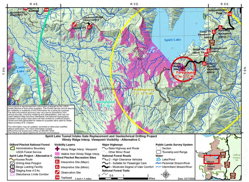
For More Information Contact:
                                                        Chris Strebig
                                                Spirit Lake Project Manager
                                                       (360) 891-5052
                                                  chris.strebig@usda.gov

       Cover photos: Spirit Lake and Mount St. Helens (top), Spirit Lake tunnel intake gate (bottom left),
       engineer reading piezometer in previously drilled bore hole (bottom center), log debris mat floating
       on Spirit Lake near the tunnel intake gate (bottom right).

In accordance with Federal civil rights law and U.S. Department of Agriculture (USDA) civil rights regulations and policies,
the USDA, its Agencies, offices, and employees, and institutions participating in or administering USDA programs are
prohibited from discriminating based on race, color, national origin, religion, sex, gender identity (including gender
expression), sexual orientation, disability, age, marital status, family/parental status, income derived from a public assistance
program, political beliefs, or reprisal or retaliation for prior civil rights activity, in any program or activity conducted or
funded by USDA (not all bases apply to all programs). Remedies and complaint filing deadlines vary by program or incident.
Persons with disabilities who require alternative means of communication for program information (e.g., Braille, large print,
audiotape, American Sign Language, etc.) should contact the responsible Agency or USDA’s TARGET Center at (202) 720-
2600 (voice and TTY) or contact USDA through the Federal Relay Service at (800) 877-8339. Additionally, program
information may be made available in languages other than English.
To file a program discrimination complaint, complete the USDA Program Discrimination Complaint Form, AD-3027, found
online at http://www.ascr.usda.gov/complaint_filing_cust.html and at any USDA office or write a letter addressed to USDA
and provide in the letter all of the information requested in the form. To request a copy of the complaint form, call (866) 632-
9992. Submit your completed form or letter to USDA by: (1) mail: U.S. Department of Agriculture, Office of the Assistant
Secretary for Civil Rights, 1400 Independence Avenue, SW, Washington, D.C. 20250-9410; (2) fax: (202) 690-7442; or (3)
email: program.intake@usda.gov.
USDA is an equal opportunity provider, employer, and lender.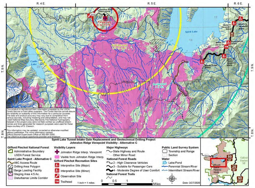
Spirit Lake Tunnel Intake Gate Replacement and Geotechnical Drilling Project Environmental Assessment

                                                                       Contents
Section 1: Introduction and Need for Action ................................................................................................ 1
  1.1 Introduction ........................................................................................................................................ 1
  1.2 Background......................................................................................................................................... 1
  1.3 Need for Action .................................................................................................................................. 3
  1.4 Protecting Downstream Communities ................................................................................................ 6
  1.5 Analysis Framework ........................................................................................................................... 7
      Public Law 97-243 ................................................................................................................................ 7
      Forest Plan and Comprehensive Management Plan .............................................................................. 8
      Forest Service Manual 2880 ................................................................................................................. 8
  1.6 Resources and Issues Dismissed from Detailed Analysis .................................................................. 8
      General Wildlife.................................................................................................................................... 9
      General Botany ..................................................................................................................................... 9
      General Aquatic Species ....................................................................................................................... 9
      Water Quality ........................................................................................................................................ 9
      Floodplains, Executive Order 11988 of May 24, 1977 ......................................................................... 9
      Essential Fish Habitat ........................................................................................................................... 9
      Wild and Scenic Rivers ......................................................................................................................... 9
      Wilderness and Wilderness Study Areas .............................................................................................. 9
      Inventoried Roadless Area .................................................................................................................... 9
      Parklands and Prime Farmlands.......................................................................................................... 10
      Social and Economic Resources ......................................................................................................... 10
  1.7 Key Issues ......................................................................................................................................... 10
Section 2: Proposed Action and Alternatives ............................................................................................. 11
  2.1 Alternative A: No Action ................................................................................................................. 11
  2.2 Activities Common to Action Alternatives B and C ........................................................................ 12
      Replacement of the Intake Gate Structure of the Spirit Lake Tunnel ................................................. 12
      Reconstruct Existing National Forest System Road 99 and Construct Temporary Roads, Staging
      Areas, and Barge Loading Facility ..................................................................................................... 14
      Geotechnical Investigation and Core Sampling .................................................................................. 15
      Public Access ...................................................................................................................................... 16
      Stabilization and Rehabilitation .......................................................................................................... 16
      Forest Plan Amendment ...................................................................................................................... 16
      Project Design Criteria ........................................................................................................................ 17
  2.3 Alternative B: Windy Ridge to Pump Station (Proposed Action) .................................................... 21
  2.4 Alternative C: Windy Ridge to Duck Bay (Intake Gate) and Helicopter Use (Geotechnical Drilling)
   ................................................................................................................................................................ 23
  2.5 Alternatives Considered but Dismissed from Detailed Analysis...................................................... 25
      Gathering of Information and Coordination ....................................................................................... 25
      Evaluation Criteria .............................................................................................................................. 25
      Drilling Component Alternatives ........................................................................................................ 26
      Intake Gate Replacement Component Alternatives ............................................................................ 26
Section 3: Analysis Measures and Environmental Effects ......................................................................... 27
  3.1 Research............................................................................................................................................ 27
      Analysis Measures .............................................................................................................................. 27
      Environmental Effects......................................................................................................................... 28
  3.2 Visual Resources .............................................................................................................................. 31
      Analysis Measures .............................................................................................................................. 31

                                                             Gifford Pinchot National Forest
                                                                            i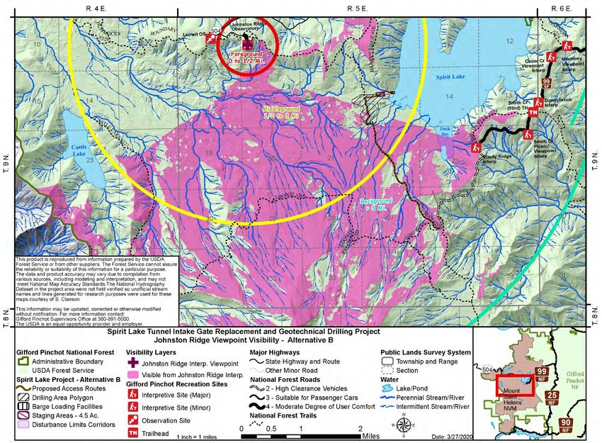
Spirit Lake Tunnel Intake Gate Replacement and Geotechnical Drilling Project Environmental Assessment

     Environmental Effects......................................................................................................................... 33
  3.3 Recreation ......................................................................................................................................... 43
     Analysis Measures .............................................................................................................................. 43
     Environmental Effects......................................................................................................................... 43
  3.4 Aviation Use ..................................................................................................................................... 46
     Analysis Measures .............................................................................................................................. 46
     Environmental Effects......................................................................................................................... 46
  3.5 Soils .................................................................................................................................................. 48
     Analysis Measures .............................................................................................................................. 48
     Environmental Effects......................................................................................................................... 49
  3.6 Hydrological Resources .................................................................................................................... 52
     Analysis Measures .............................................................................................................................. 52
     Environmental Effects......................................................................................................................... 52
  3.7 Aquatic Species ................................................................................................................................ 56
     Analysis Measures .............................................................................................................................. 56
     Environmental Effects......................................................................................................................... 57
  3.8 Terrestrial (Wildlife) Species ........................................................................................................... 60
     Analysis Measures .............................................................................................................................. 60
     Environmental Effects......................................................................................................................... 62
  3.9 Botanical Species.............................................................................................................................. 65
     Analysis Measures .............................................................................................................................. 65
     Environmental Effects......................................................................................................................... 67
  3.10 Heritage Resources ......................................................................................................................... 68
     Analysis Measures .............................................................................................................................. 68
     Environmental Effects......................................................................................................................... 69
Section 4: Agencies and Individuals Contacted and Consulted .................................................................. 72
  4.1 Tribal Partners .................................................................................................................................. 72
  4.2 Washington State Department of Archaeology ................................................................................ 72
  4.3 U.S. Army Corps of Engineers ......................................................................................................... 73
  4.4 Research Community ....................................................................................................................... 73
     Weekly Deputy Regional Forester and Research Station Director Update ........................................ 73
     Monthly Coordination Call with the Research Station Land and Watershed Management Program . 73
     Interdisciplinary Team Member.......................................................................................................... 74
     Mount St. Helens National Volcanic Monument Implementation and Monitoring Working Group . 74
Section 5: Proposed Forest Plan Amendment (Alternatives B and C)........................................................ 75
  5.1 Purpose of the Amendment .............................................................................................................. 75
  5.2 Substantive Requirements of the Rule .............................................................................................. 75
     Scope and Scale of the Amendment ................................................................................................... 75
     Application of Substantive Requirements........................................................................................... 76
  5.3 Using the Best Scientific Information to Inform the Amendment.................................................... 76
References ................................................................................................................................................... 77

                                                                     List of Tables
Table 1. Project design criteria to minimize the environmental impacts of the project .............................. 17
Table 2. Invasive plant species known to occur in or near Spirit Lake project area ................................... 66

                                                           Gifford Pinchot National Forest
                                                                          ii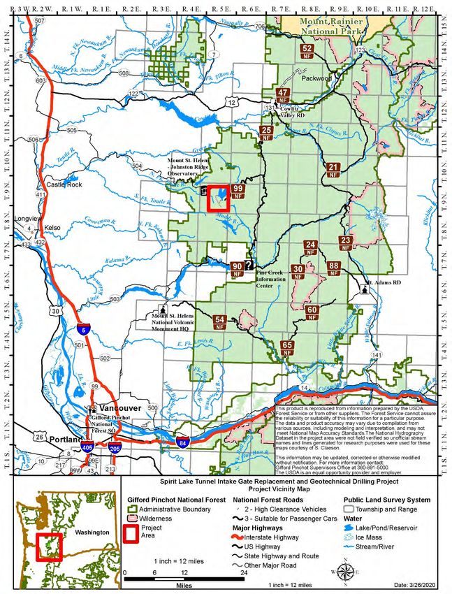
Spirit Lake Tunnel Intake Gate Replacement and Geotechnical Drilling Project Environmental Assessment
List of Figures
Figure 1. Spirit Lake Tunnel Intake Gate and Geotechnical Drilling Project vicinity map. ........................ iv
Figure 2. Temporary pump station and facilities at Spirit Lake in the early 1980s. ..................................... 2
Figure 3. Short-term location of pumping pipeline (early 1980s) on the debris blockage. The access road
(now Truman Trail) is pictured in the center of photo. ......................................................................... 2
Figure 4. Rock “heave” restricting the 11 feet high tunnel to a 6 feet high passage. ................................... 4
Figure 5. Forest Service engineer surveys exposed borehole casing from 1980s drilling effort, illustrating
erosion effects at the debris blockage area near Spirit Lake. Casing was originally two feet above
ground. .................................................................................................................................................. 5
Figure 6. May 1980 flooding in Cowlitz County. ......................................................................................... 7
Figure 7. Overview map of action alternatives (B and C). ......................................................................... 13
Figure 8. Alternative B: Windy Ridge to Pump Station (proposed action) overview map. ........................ 22
Figure 9. Alternative C: Windy Ridge to Duck Bay (intake gate) and helicopter use (geotechnical drilling)
overview map. ..................................................................................................................................... 24
Figure 10. View from Windy Ridge interpretive site looking west. Spirit Lake and the shore area known
as “Duck Bay” are in view along the lower portion of the photo, with the current administrative
utility-terrain vehicle trail on the left, and Pumice Plain is in the middle........................................... 32
Figure 11. View from Johnston Ridge Observatory amphitheater, with the Pumice Pain visible in the
middleground and background............................................................................................................ 32
Figure 12. Hikers traversing along the Truman Trail, looking north. ......................................................... 33
Figure 13. Truman Trail near Red Rock Springs, showing evidence of blasting or excavation for road
building in the 1980s. .......................................................................................................................... 33
Figure 14. Seen Area map displaying areas that can be seen from Windy Point within foreground (0 to 0.5
mile) and middleground (0.5 to 3 miles) for the temporary access road proposed under alternative B
............................................................................................................................................................ 36
Figure 15. Seen Area map displaying areas that can be seen from Johnston Ridge within foreground (0 to
0.5 mile) and middleground (0.5 to 3 miles) for the temporary access road proposed under alternative
B .......................................................................................................................................................... 37
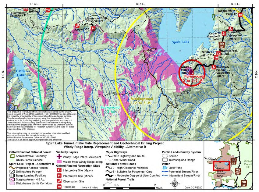
Figure 16. Seen Area map displaying areas that can be seen from Windy Point within foreground (0 to 0.5
mile) and middleground (0.5 to 3 miles) for the temporary access road proposed under alternative C
............................................................................................................................................................ 41
Figure 17. Seen Area map displaying areas that can be seen from Johnston Ridge within foreground (0 to
0.5 mile) and middleground (0.5 to 3 miles) for the temporary access road proposed under alternative
C .......................................................................................................................................................... 42
Gifford Pinchot National Forest
iii
Spirit Lake Tunnel Intake Gate Replacement and Geotechnical Drilling Project Environmental Assessment

Figure 1. Spirit Lake Tunnel Intake Gate and Geotechnical Drilling Project vicinity map.

                                     Gifford Pinchot National Forest
                                                   iv
Section 1: Introduction and Need for Action
1.1 Introduction
The purpose of this environmental assessment is to disclose and document the anticipated
environmental effects of the proposed Spirit Lake Tunnel Intake Gate Replacement and Geotechnical
Drilling Project within Mount St. Helens National Volcanic Monument, in Skamania County,
Washington (figure 1).
This analysis complies with the National Environmental Policy Act of 1969, as amended [42 USC
4321–4347], the National Forest Management Act, the Council of Environmental Quality regulations,
and Forest Service regulations 36 Code of Federal Regulations (CFR) 220.4. This analysis is not
intended to serve as a land or resource management document for the Gifford Pinchot National Forest.
The Gifford Pinchot National Forest Supervisor is the responsible official who will determine if there
are no significant 1 impacts based on this environmental assessment, and associated project record, and
then prepare a draft decision notice and finding of no significant impact, which will be published for a
45-day objection period. Following the 45-day objection period, the Forest Service may publish a final
decision notice.
The project is located in Township 9 North, Range 5 East, Sections 10, 15, 22, and 27 (see figure 1).

1.2 Background
The eruption of Mount St. Helens in 1980 resulted in a massive debris avalanche and pyroclastic flow
causing sweeping changes to the watershed. The eruption delivered approximately 3 billion cubic
yards of sediment into the Toutle, Cowlitz, and Columbia rivers, killed 57 people, and drastically
changed the physical and socio-economic landscape. The eruption material formed a natural dam that
blocked the outlet of Spirit Lake, where it had previously flowed into the North Fork Toutle River.
Blown-down timber that entered the lake resulted in a floating log mat that still occupies about 25
percent of the lake surface. A catastrophic break of the blockage by high water in Spirit Lake could
release more than 300,000 acre-feet of water and 2.4 billion cubic yards of sediment, rivaling the
devastating mudflows of the 1980 eruption (NASEM 2017).

In 1982, at the direction of the President and the Federal Emergency Management Agency, the U.S.
Army Corps of Engineers (the Corps of Engineers) in consultation with the Forest Service, responded
to the potential threat of a catastrophic breach or overtopping of the debris avalanche by establishing
an interim pumping station in the southwest corner of Spirit Lake. This temporary measure to stabilize
the lake level included a barge-mounted pumping facility, an access road from Windy Ridge (across
the debris avalanche), workshops and short-term housing, and an area for storage of thousands of
gallons of fuel (figure 2).

To assess possible lake-level control measures, the Corps of Engineers completed an environmental
impact statement in April 1984. The selected alternative was the current tunnel through Harry’s Ridge,
which drains Spirit Lake water into South Fork Coldwater Creek, a tributary of the Nork Fork Toutle
River.

1
 The term “significant,” as used in the environmental analysis process, requires consideration of both context
and intensity (40 CFR 1508.27).

                                         Gifford Pinchot National Forest
                                                        1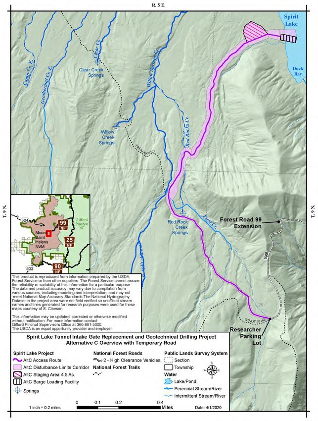
Spirit Lake Tunnel Intake Gate Replacement and Geotechnical Drilling Project Environmental Assessment

Work on the tunnel began in July 1984 and was completed by April 1985. The constructed tunnel, built
under emergency conditions, is approximately 1.6-miles long and 11 feet in diameter, with a slightly
narrowed diameter in areas of tunnel lining reinforcement. To construct the tunnel intake gate at Spirit
Lake, the Corps of Engineers once again used the road from Windy Ridge (across the debris
avalanche) to access the lake shore near the pumping station, then barged the cranes and other heavy
equipment across the lake (figure 3).

                  Figure 2. Temporary pump station and facilities at Spirit Lake in the
                  early 1980s.

                  Figure 3. Short-term location of pumping pipeline (early 1980s) on
                  the debris blockage. The access road (now Truman Trail) is
                  pictured in the center of photo.

As the agency responsible for managing the Mount St. Helens National Volcanic Monument, the
Forest Service also operates and maintains the aging tunnel system. Despite the overall success of the
existing tunnel, major repairs in 1995, 1996, and 2016 required extended closures of the tunnel gate
and outlet flow, which allowed the lake to rise to the maximum safe operating level.

                                      Gifford Pinchot National Forest
                                                     2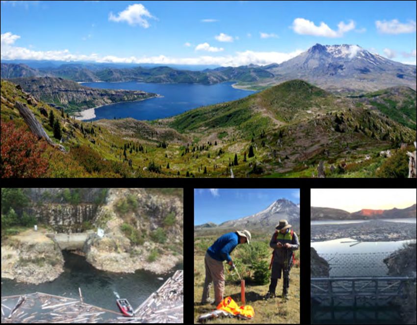
Spirit Lake Tunnel Intake Gate Replacement and Geotechnical Drilling Project Environmental Assessment

The Gifford Pinchot National Forest initiated the Spirit Lake Motorized Access Environmental
Assessment in March of 2017. The 2017 project originally had two purposes: (1) provide motorized
utility-terrain vehicle access to the lake shore where Forest Service personnel access their workboat
for tunnel operations and maintenance, and (2) provide motorized access and allow for geotechnical
investigations including ground penetrating radar and core sampling (drilling). After the draft decision
notice and objection review period, Gifford Pinchot National Forest staff determined the best approach
was to split the decision, and in the summer of 2018 issued a signed decision notice to provide
motorized utility-terrain vehicle access to the lake shore where Forest Service personnel access their
workboat for tunnel operations and maintenance (purpose 1). The Gifford Pinchot National Forest then
issued a second draft decision notice focused on motorized access and drilling (purpose 2). After
reviewing the objections received in response to the second draft decision, Forest Service leadership
determined it was prudent to undertake additional analysis related to the impacts to research,
alternative access methods for drilling, and Gifford Pinchot National Forest Land and Resource
Management Plan consistency.

Throughout the summer and fall of 2019, Spirit Lake managers researched various (11 plus) access
options (see Appendix A: Alternatives Considered but Eliminated from Detailed Study). During that
time, Gifford Pinchot National Forest and Regional Forest Service leadership were also briefed on
recent damage at the tunnel inlet structure and the necessary repairs and maintenance to the inlet
structure predicted in the upcoming years. After reviewing the information, Forest Service leadership
determined to combine, into one project, the access needs for the core sampling (drilling) and access
and repair work for the intake gate replacement, since they would overlap in time and space. In
addition to the need for these actions to occur as soon as possible, it was clear that there would be
overlapping access needs for each action. An interdisciplinary team was assembled in September 2019
to address this Regional priority project. In order to address the need for the project and effectively
analyze the environmental effects, the team was purposefully comprised of multi-agency inter-
disciplinary team members from the Gifford Pinchot National Forest, U.S. Forest Service Pacific
Northwest Research Station, U.S. Forest Service Regional Office for the Pacific Northwest Region,
U.S. Forest Service Washington DC Office and Enterprise Program, and the U.S. Army Corps of
Engineers.

1.3 Need for Action
There is a need to ensure the protection of public safety, health, property, and the environment from a
catastrophic breach of the Spirit Lake natural debris blockage caused by the 1980 debris avalanche.
Currently there is inadequate data to inform risk management decisions and an increasing risk of
failure of the existing outlet infrastructure (tunnel intake gate system), which could lead to a
catastrophic failure of the debris blockage.
The Forest Service must adhere to its policy that instructs the agency to execute activities associated
with geological resources and hazards for public health and safety. Specifically, policy direction from
Forest Service Manual 2880 directs the Forest Service to “manage geologic hazards on National Forest
System lands to ensure the protection of public safety, health, property, and the environment.”
During its nearly 35-year lifespan, the tunnel infrastructure for controlling the water level of Spirit Lake
has deteriorated due to age. A rock heave from external pressures in portions of the tunnel (figure 4) has
reduced capacity and demonstrates an increased risk of failure (NASEM 2017, Grant et al. 2017). There
is currently no secondary outflow or spillway to serve as a back-up if the existing tunnel fails to
function.

                                      Gifford Pinchot National Forest
                                                     3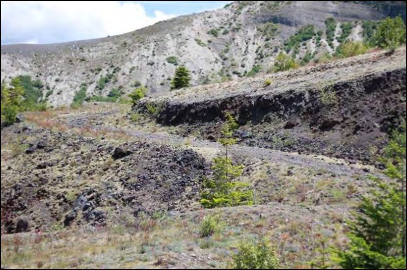
Spirit Lake Tunnel Intake Gate Replacement and Geotechnical Drilling Project Environmental Assessment

                 Figure 4. Rock “heave” restricting the 11 feet high tunnel to a 6 feet
                 high passage.

The cast iron tunnel intake gate is designated as a fracture-critical hydraulic steel structure as per the
Corps of Engineers regulations (ETL 1110-2-584 and ER 1110-2-8157). Absence of redundancy in the
gate system and inability to isolate the gate prevents a thorough inspection of all aspects of the intake
gate structure as required by the Corps of Engineers regulations and creates an elevated risk of
uncontrolled water release to tunnel inspectors and workers. Consequently, the tunnel intake gate does
not meet current design standards. To address the worsening tunnel component situation, the Forest
Service has worked with Cowlitz County to prepare a Spirit Lake Emergency Response Plan for
monitoring, communicating, and potentially evacuating people downstream should a tunnel outlet
failure occur.
The physical properties of the debris blockage are not well understood because there is currently
insufficient geologic, hydrogeological, and seismic data to characterize the debris blockage. The
current outdated and incomplete data prevents accurate determination of a safe water level in Spirit
Lake. Due to the lack of current information about safe water levels, the Forest Service and the Corps
of Engineers are constrained in their abilities to plan and schedule implementation of monitoring and
quality control of the current tunnel infrastructure and long-term outflow resiliency.
Updated information is needed to map the contact boundaries between the overlying pyroclastic
deposits, debris avalanche, and underlying rock. Subsurface exploratory drilling, along with other
ongoing geophysical investigations, will provide a more complete three-dimensional picture of the
character of the blockage and vulnerabilities to vertical incision and internal erosion.
Previous models and studies by the U.S. Geological Survey and the Corps of Engineers provide
incomplete and inconsistent information with respect to the risk of liquefaction and erosional failure
within the debris blockage, and the impact of future decisions related to geologic hazard management
(figure 5).

                                      Gifford Pinchot National Forest
                                                     4
Spirit Lake Tunnel Intake Gate Replacement and Geotechnical Drilling Project Environmental Assessment
Figure 5. Forest Service engineer surveys exposed borehole casing
from 1980s drilling effort, illustrating erosion effects at the debris
blockage area near Spirit Lake. Casing was originally two feet above
ground.
There is a continued and increasing need to perform risk mitigation actions on the tunnel system,
debris blockage, and surrounding area to better understand and stabilize water containment and reduce
to an acceptable level the risk of a debris blockage breach.
Two recently published scientific reports emphasize the inadequacy of current information and the need
to characterize the debris blockage. The National Academy of Science, Engineering, and Medicine
completed a report in 2017 titled: A Decision Framework for Managing the Spirit Lake and Toutle
River System at Mount St. Helens. The report states, “The Spirit Lake debris blockage consists of a
poorly characterized (from a geotechnical point of view) chaotic, permeable mixture of sand, gravel,
boulders, and organic materials. The boundaries of the blockage do not easily lend themselves to clear
definition, or even to identification of exactly where the blockage begins and ends…At its crest the
blockage ranges from 200 feet to more than 500 feet in thickness. Both the avalanche sediment and the
overlying pyroclastic sediment are highly erodible” (NASEM 2017, page 35). The report reiterates the
weakness of relying on outdated information when it states that “assessments were made of the
hydrology and stability of these deposits with respect to piping, liquefaction, failure during seismic
loading, and erosion soon after the 1980 eruption, but no follow-up analysis has been conducted to
determine how the hydrologic and hydraulic settings have changed, or how such possible changes affect
the long-term geotechnical stability of the debris blockage” (NASEM 2017, pages 38–39).
Also in 2017, the U.S. Geological Survey and U.S. Forest Service Pacific Northwest Research Station
produced a general technical report focused on the geologic, geomorphic, and hydrologic context
underlying options for long-term management of the Spirit Lake outlet near Mount St. Helens,
Washington (PNW-GTR-954; Grant et al. 2017). Grant et al. found “…that the elevation of the contact
between the debris avalanche and overlying pyroclastic deposits at the crest of the blockage sets the
safety limit for ensuring that a breakout flood does not occur. Although previous studies have provided
a sound technical foundation for establishing safe operating elevations of the lake, a refined three-
dimensional picture of how this contact is arrayed spatially would provide increased confidence for
Gifford Pinchot National Forest
5Spirit Lake Tunnel Intake Gate Replacement and Geotechnical Drilling Project Environmental Assessment
any management action” (page 109). The report also stated that “…additional drilling to provide a
more completed three-dimensional picture of the character of the blockage at depth would help better
understand what might happen if the blockage began to break. Specifically, are there regions within
the blockage where the size of sub-surface material in the debris-avalanche deposit might be expected
to resist vertical incision if a breakout were to occur” (Grant et al. 2017, page 111).
The downstream communities of Toutle, Silver Lake, Toledo, Lexington, Castle Rock, Kelso, and
Longview, Washington, depend on the Forest Service for safe management of the Spirit Lake water
level and outflow. Currently, the safety of downstream communities relative to the stability of the
debris blockage is built on assumptions, based on other assumptions, from almost 35-year old data.
Residents of these communities are living and working downstream from a poorly understood natural
debris dam that utilizes a dated tunnel outlet infrastructure system that is documented to be in poor
condition and subject to failure. Forest Service leadership determined the current risk situation
generated by the Spirit Lake tunnel intake gate and the debris blockage is unacceptable. The Forest
Service is solely responsible for the management of the Spirit Lake outflow as a geologic hazard and
must take necessary action.
In response to the need, the Gifford Pinchot National Forest Supervisor is analyzing proposals to
enhance protection to the communities downstream of Spirit Lake, increase safety for agency
maintenance personnel, and reduce the risk of economic hardship to the region as a result of a
breakout flood from Spirit Lake. Two important actions toward satisfying these goals are: (1) obtain
geotechnical subsurface drilling data to more accurately determine and predict safe conditions for
existing and possible future alternate systems to control water levels in Spirit Lake; and (2) replace the
tunnel intake gate structure to improve lake level management, safety, and monitoring (inspection) of
the gate.
1.4 Protecting Downstream Communities
The U.S. Geological Survey estimated the communities of Toutle, Silver Lake, Toledo, Lexington,
Castle Rock, and the cities of Kelso and Longview, Washington, are within the projected impact area
(inundation area) if a Spirit Lake outburst flood were to occur. Forest Service managers continue to
work with local emergency managers to prepare for a potential flood and to practice the emergency
response.
A catastrophic break of the blockage by high water in Spirit Lake could release more than 300,000
acre-feet of water and 2.4 billion cubic yards of sediment, rivaling the devastating mudflows of the
1980 eruption (NASEM 2017). A flood of this magnitude would likely inundate the Port of Longview
for several months and temporarily close the ports of Portland, Vancouver, and Kalama. The railroad
and Interstate 5 are also within the inundation area. There is approximately $3.65 billion of property
value within the inundation area (figure 6). The Port of Longview alone generates $1.5 billion and
employs approximately 10 percent of workers in Cowlitz County. The Forest Service recognizes a
flood at this scale would be economically devastating to the region and threaten the life and safety of
the public and emergency response workers.
Gifford Pinchot National Forest
6Spirit Lake Tunnel Intake Gate Replacement and Geotechnical Drilling Project Environmental Assessment
Figure 6. May 1980 flooding in Cowlitz County.
1.5 Analysis Framework
The Gifford Pinchot National Forest Supervisor is the responsible official who will determine if the
proposed activities will have a finding of no significant impact, based on this environmental
assessment and public comments. The Forest Supervisor’s decision would then be documented in a
decision notice. The decision notice will include rationale for the alternative selected.
Public Law 97-243
The Forest Service is managing the Monument consistent with the intent of the enabling legislation
(Public Law 97-243, 1982). This law directs that, “The Secretary [of Agriculture] acting through the
Forest Service shall administer the Monument as a separate unit within the boundary of the Gifford
Pinchot National Forest, in accordance with the appropriate laws pertaining to the National Forest
System, and in accordance with the provisions of this Act.” (Public Law 97-243, Section 4(a)).
The enabling legislation Section 4(b)(1) states, “The Secretary shall manage the Monument to protect
the geologic, ecologic, and cultural resources, in accordance with the provisions of this Act allowing
geologic forces and ecological succession to continue substantially unimpeded.”
The enacting legislation includes multiple provisions within the administration section of the Act
related to taking action or measures to control (mitigate) damage to resources adjacent to the
Monument (downstream communities), public safety, and preventing loss of life and property. Below
are listed the provisions, in order, from the administration section of the law, which is the primary
guidance for the Monument.
“Section 4(b)(1) The Secretary shall manage the Monument to protect the geologic, ecologic, and
cultural resources, in accordance with the provisions of this Act allowing geologic forces and
ecological succession to continue substantially unimpeded.
Section 4(b)(2) The Secretary may take action to control fire, insects, diseases, and other agents that
might (A) endanger irreplaceable features within the Monument or (B) cause substantial damage to
significant resources adjacent to the Monument.
Gifford Pinchot National Forest
7Spirit Lake Tunnel Intake Gate Replacement and Geotechnical Drilling Project Environmental Assessment
Section 4(b)(3) Nothing in this Act shall prohibit the Secretary from undertaking or permitting those
measures within the Monument reasonably necessary to ensure public safety and prevent loss of life
and property” (Public Law 97-243).
The Monument Act, within the Scientific Study and Research subsection of the Administration
section, goes on further to state:
“Section 4(c) The Secretary shall permit the full use of the Monument for scientific study and research,
except that the Secretary may impose such restrictions as may be necessary to protect public health
and safety and to prevent undue modification of the natural conditions of the Monument.
Section 4(d) In order to protect the significant features of the Monument, reduce user conflict, and
ensure visitor safety, the Secretary is authorized to control time and means of access and use of the
Monument or parts thereof: Provided, that nothing in this section shall be construed as to prohibit the
use of motorized vehicles, aircraft of motorboats for emergency and other essential administrative
services, including those provided by State and local governments, or when necessary for authorized
research” (Public Law 97-243).
Forest Plan and Comprehensive Management Plan
Guidance for management of the legislated Monument comes from the Mount St. Helens National
Volcanic Monument’s Comprehensive Management Plan (comprehensive management plan), which is
fully incorporated into the Gifford Pinchot National Forest Land and Resource Management Plan
(forest plan), as amended by the Record of Decision for Amendments to Forest Service and Bureau of
Land Management Planning Documents within the Range of the Northern Spotted Owl. The forest
plan provides over-arching goals, objectives, and project-level standards and guidelines forestwide and
within the Monument. Proposed projects are required to be in compliance with the forest plan, and
therefore, the comprehensive management plan, or a plan amendment is required.
Forest Service Manual 2880
Forest Service Manual 2880 contains legal authorities, objectives, policies, responsibilities,
instructions, and guidance for Forest Service line officers and primary staff to plan and execute
assigned programs and activities associated with geological resources, hazards, and services.
Specifically, Forest Service Manual 2880 directs the Forest Service to “manage geologic hazards on
National Forest System lands to ensure the protection of public safety, health, property, and the
environment.” Direction within Forest Service Manual 2880 also recognizes mitigating actions may
involve corresponding policy, such as Forest Service Manual 7500 Water Storage and Transmission
(Dam Safety).
1.6 Resources and Issues Dismissed from Detailed Analysis
National Environmental Policy Act regulations require the agency to identify and eliminate from
detailed study those issues that are not significant or that have been covered by prior environmental
review, to narrow the scope of the analysis. Reasons for eliminating issues from detailed study include
when the issues are related to the following:
• General opinions or position statements not specific to the proposed action;
• Items addressed by other laws, regulations, or policies;
• Items not relevant to the potential effects of the proposed action, or otherwise outside the scope of
this analysis; and/or
• Items that have no or negligible effects.
Gifford Pinchot National Forest
8Spirit Lake Tunnel Intake Gate Replacement and Geotechnical Drilling Project Environmental Assessment
Although changes in management direction could influence the nature of future projects, the timing,
location, and details of future projects are currently unknown. Impacts of future projects would need to
be assessed on a project-by-project basis as they are proposed.
Eliminated issues are not addressed beyond the rationale provided below.
General Wildlife
The action alternatives have the potential to affect individuals of general wildlife species, but the
activities are not anticipated to affect any wildlife populations as a whole.
General Botany
The action alternatives have the potential to affect individuals of general botanical species, but the
activities are not anticipated to affect any botanical populations as a whole.
General Aquatic Species
The action alternatives have the potential to affect individuals of general aquatic species, but the
activities are not anticipated to affect any aquatic populations as a whole.
Water Quality
No activities under any alternatives will result in any streams being listed on the 303(d) list for
impaired water quality.
Floodplains, Executive Order 11988 of May 24, 1977
The action alternatives will not affect the quality of existing floodplains owing to the temporary nature
of the proposed activities. The action alternatives are consistent with Executive Order 11988 since the
proposed activities conforms to Washington State’s floodplain protection standards.
Essential Fish Habitat
Essential fish habitat is designated under the Magnuson-Stevens Fishery Conservation and
Management Act of 1976 to protect waters and substrates necessary for Chinook, coho, and pink
salmon (Oncorhynchus tshawytscha, O. kisutch, and O. gorbuscha, respectively) spawning, breeding,
feeding, and growth to maturity (National Marine Fisheries Services 2002). There is no designated
essential fish habitat for pink salmon on the Gifford Pinchot National Forest, and there is no essential
fish habitat for Chinook or coho salmon within the project area. Therefore there will be No Effect to
essential fish habitat for any of the alternatives.
Wild and Scenic Rivers
There are no designed wild and scenic rivers within the project area, therefore there are no effects to
designated wild and scenic rivers.
Wilderness and Wilderness Study Areas
There are no designed wilderness areas or wilderness study areas within the project area, therefore
there are no effects to designed wilderness and wilderness study areas.
Inventoried Roadless Area
The project area is not located within any designated inventoried roadless area under the 2001
Roadless Rule, therefore there are no effects to designated inventoried roadless areas.
Gifford Pinchot National Forest
9Spirit Lake Tunnel Intake Gate Replacement and Geotechnical Drilling Project Environmental Assessment
Parklands and Prime Farmlands2
There are no parklands or prime farmland within the project area, therefore there are no effects to
parklands or prime farmlands.
Social and Economic Resources
The action alternatives are not anticipated to create any full-time equivalent positions, nor is it
anticipated to create any impacts to social resources (county services, school systems, etc.) within the
Skamania County communities. The project would have short-term economic impacts due to
construction related activities.
1.7 Key Issues
Key issues are generated by the public, other agencies, organizations, and the Forest Service and are in
response to the proposed action. Key issues provide focus for the analysis of environmental effects and
may influence alternative development, including development of project design criteria. Key issues
serve to highlight effects or unintended consequences that may occur from the proposed action and
alternatives, giving opportunities during the analysis to reduce adverse effects and compare trade-offs
for the responsible official and public to understand. Key issues are statements of cause and effect,
linking environmental effects to actions, including the proposed action (Forest Service Handbook
1909.15, 12.4).
The creation of additional alternatives, including those dismissed from detailed study, and the
development of project design criteria was driven by the following identified concerns:
• Current and future research;
• Visual and recreation resources;
• Access options; and
• Invasive species introduction and spread (aquatic and terrestrial).
2
Prime farmland is a designation given by the National Resources Conservation Service for land use and cover,
whose criteria for national legislation is concerned with the environment and with agricultural commodity
production (U.S. Department of Agriculture Handbook Number 18).
Gifford Pinchot National Forest
10Section 2: Proposed Action and Alternatives
In response to the need, identified above, the Gifford Pinchot National Forest Supervisor has analyzed
alternatives to enhance protection to the communities downstream of Spirit Lake, increase safety for
agency maintenance personnel, and reduce the risk of economic hardship to the region as a result of a
breakout flood from Spirit Lake. Two important actions toward satisfying these goals are: (1) obtain
geotechnical subsurface drilling data to more accurately determine and predict safe conditions for existing
and possible future alternate systems to control water levels in Spirit Lake; and (2) replace the tunnel
intake gate structure to improve lake level management, safety, and monitoring (inspection) of the gate.
To meet these two goals the Forest Service has proposed to:
• Replace the intake gate structure of the spirit lake tunnel;
• Reconstruct portions of National Forest System road 99;
• Construct temporary access roads, staging areas, and a barge loading facility;
• Conduct geotechnical investigation and core sampling within the debris blockage; and
• During and after the project there will be stabilization and rehabilitation activities.
The alternatives in this environmental assessment were developed to respond to the need for action within
the decision framework for the Forest Service.
The Spirit Lake outflow refers to the whole system that removes water from Spirit Lake. The Spirit Lake
outflow was referred to as the Spirit Lake outlet in previous documents. The Spirit Lake tunnel is
currently the only way for water to leave Spirit Lake and has a tunnel intake gate structure to control
water flow.
2.1 Alternative A: No Action
This alternative represents reasonably foreseeable conditions that would be expected if the Forest Service
does not perform geotechnical drilling in the Spirit Lake debris blockage, does not replace the Spirit Lake
tunnel intake gate structure, and does not move the excavated rock debris spoils pile located in front of
the intake channel. The spoils are within Spirit Lake and left over from the original tunnel construction.
The Spirit Lake outflow would continue to not meet current dam safety standards to include alternate,
redundant gates or additional methods of closure in case of an operations failure; and would not allow for
positive (complete) gate closure for personnel safety during inspection, repair, or maintenance activities.
The excavation spoils pile located in front of the intake channel in Spirit Lake would continue to
accumulate log debris mats and obstruct administrative lake access for inspection, repair, and
maintenance, which could result in an elevated level of lake water and increase the geohazard risk. The
excavation spoils pile is composed of rock, soil, and woody debris generated during original tunnel
construction. The Spirit Lake outflow would be less able to safely maintain lake levels or fully contribute
to controlled release of water during the summer season. Controlled release is important for active
management of the lake level, especially during maintenance and operations. The existing, aged fracture-
critical intake gate, identified in the October 2016 comprehensive Spirit Lake tunnel inspection report as a
gate that cannot be thoroughly inspected, would not be replaced and would continue to deteriorate.
Geotechnical investigation, core sampling, and installation of monitoring instruments would not occur
within the debris blockage. Decisions related to the management of Spirit Lake water levels will not be
informed by a current characterization of the debris blockage damming the lake; the location and behavior
Gifford Pinchot National Forest
11Spirit Lake Tunnel Intake Gate Replacement and Geotechnical Drilling Project Environmental Assessment
of groundwater in the blockage; a quantified characterization of risks posed by volcanic activity on Spirit
Lake water levels; or the response of the debris blockage to local and regional seismic events. Existing
elevated lake levels and potential future Spirit Lake outflow alternatives would be difficult or impossible
to assess without geotechnical investigation and core sampling.
The no-action alternative does not reduce the risk presented by the Spirit Lake and Toutle River system at
Mount St. Helens. Spirit Lake outflow breach models suggest that a full-catastrophic breach of the debris
blockage could inundate substantial portions of cities along the Toutle and Cowlitz rivers including Kelso
and Longview, Washington. These models were conducted in early 1980 by the U.S. Geological Survey
and are public record.
2.2 Activities Common to Action Alternatives B and C
Replacement of the Intake Gate Structure of the Spirit Lake Tunnel
Alternatives B and C propose to dredge approximately 7,100 cubic yards of spoils material from the
existing spoils pile in front of Spirit Lake tunnel intake channel. Dredged material includes woody debris,
excavated rock, ash, pumice, and sand. Dredged material would first be placed onto a scow barge.
Approximately 2,700 cubic yards of suitable dredged material could be used to construct a permanent
access ramp from the lake to the existing helipad adjacent to the tunnel intake. The remaining dredged
material would be moved up to 900 feet away from the Spirit Lake tunnel intake and placed onto the lake
bottom. Figure 7 provides an overview map of both action alternatives.
The access ramp adjacent to the tunnel intake would have positive drainage and would remain in place to
be utilized for future management activities. Water would be directed across the ramp as a ford or
rerouted adjacent to the ramp. The ramp would be stabilized after implementation to limit the need for
future maintenance.
Construction of a cofferdam 3 is proposed to stop water flow through the intake channel and allow access
to the tunnel intake gate and intake structure at Spirit Lake. Cofferdam construction may consist of
materials such as large sandbags filled with gravel and sand material or pile installation. A pump would be
used as needed to evacuate water from the dewatered intake structure area. Additional pumps would
maintain the lake level during construction by pumping water from the lake to downstream of the intake
gate structure. Estimated pumping capacity is approximately 25,000 gallons per minute for 10 to 12 hours
per day to offset average summer water inflow to Spirit Lake.
Alternatives B and C propose demolition, removal, and disposal of the existing trash rack and gate at the
intake structure of the Spirit Lake tunnel.
Construction of a new intake-control structure at the remaining intake wall would include concrete
formwork and a cast in-place rehabilitated concrete structure. A new trash rack, intake gates and service
platform would be fabricated and installed.
Boats and barges carrying equipment and/or crews will need to traverse through the floating log mat at
Spirit Lake. To manage travel through the logs, crews may utilize log broncs or buoy systems to keep
floating logs away from equipment and boats.
3
Cofferdam: A watertight enclosure pumped dry to permit construction work below the waterline.
Gifford Pinchot National Forest
12Spirit Lake Tunnel Intake Gate Replacement and Geotechnical Drilling Project Environmental Assessment
Figure 7. Overview map of action alternatives (B and C).
Gifford Pinchot National Forest
13Spirit Lake Tunnel Intake Gate Replacement and Geotechnical Drilling Project Environmental Assessment
The sequencing described below would occur during summer and early fall. Winter-like conditions in late
fall, winter, and spring create unsafe conditions for construction.
Gate Sequencing Phase 1
(1 to 2 seasons, each season is estimated at 122 days)
• Construction of temporary access road;
• Construction of staging area near lake;
• Removal of spoils pile at tunnel intake;
• Large equipment (over 50,000 pounds) would be mobilized once each season;
• Crews would travel from Windy Ridge and across the lake by boat daily to complete work;
• Estimated 1,980 passenger vehicle passes per season;
• Estimated 84 passes of truck-tractors per season; and
• Estimated 464 single-unit truck passes per season.
Gate Sequencing Phase 2
(1 season, each season is estimated at 122 days)
• Maintenance on temporary access road as needed;
• Construction of coffer dam;
• Removal and replacement of intake gate; must occur in single season;
• Large equipment (over 50,000 pounds) would be mobilized once each season;
• Crews would travel from Windy Ridge and across the lake by boat daily to complete work;
• Estimated 1,980 passenger vehicle passes per season;
• Estimated 84 passes of truck-tractors per season; and
• Estimated 464 single-unit truck passes per season.
Reconstruct Existing National Forest System Road 99 and Construct
Temporary Roads,4 Staging Areas, and Barge Loading Facility
Specific locations and details of implementation can be found in the separate sections for alternative B
and alternative C.
Construction of a staging area could occur at the Windy Ridge recreation site or the Smith Creek Picnic
recreation site, or at both locations. Improvement of the National Forest System road 99 extension from
the Windy Ridge recreation site to the researcher parking lot is proposed in order to allow safe passage for
trucks that could include lowboy trailers. The terminus of National Forest System road 99 extension,
known as the researcher parking lot, may be increased in size by an estimated 0.2 acre for use as a staging
area during implementation and material disposal after the completion of project work.
4
36 CFR 212 definitions: Temporary road or trail – a road or trail necessary for emergency operations or authorized
by contract, permit, lease, or other written authorization that is not a National Forest System road or trail and that is
not included in a National Forest System transportation atlas.
Gifford Pinchot National Forest
14You can also read