10.14. Surveys of Eagles and Other Raptors
←
→
Page content transcription
If your browser does not render page correctly, please read the page content below
REVISED STUDY PLAN

10.14. Surveys of Eagles and Other Raptors
     10.14.1. General Description of the Proposed Study

The Surveys of Eagles and Other Raptors began in 2012 to prevent inadvertent take of raptors by
providing information on raptor avoidance zones to Project personnel in the field in 2012. The
Surveys of Eagles and Other Raptors will continue in 2013 and 2014, providing data for
avoidance of raptor take, for the assessment of Project impacts, and ultimately for any necessary
applications for federal eagle nest and take permits.
Study Goal and Objectives
The goal of the Surveys of Eagles and Other Raptors is to characterize population size,
productivity, nesting phenology, and habitat use of raptor species to inform the prediction and
quantification of impacts that may result from the proposed Project, and to provide information
required for a possible application(s) for federal eagle take (lethal or disturbance take, see below)
and/or eagle nest take permits. Common and scientific names of raptors that may occur in the
Project area are listed in Table 10.14-1.
Six objectives have been identified for study:
1) Enumerate and identify the locations and status of raptor nests and territories that could be
   affected by Project construction and operations. Four specific tasks are associated with this
   objective:
   a) Review and synthesize existing nest data for eagles and other raptors: Identify and assess
       the status of previously recorded nest locations of various species, including geographic
       coordinates, annual nest activity, descriptions of nest site characteristics, and general
       descriptions of cliff habitat in the proximity of each site.
   b) Conduct field surveys to locate and characterize nests: Locate and map Bald Eagle and
       Golden Eagle nests in the Project study area, identifying all active and inactive nests and
       alternative nest sites. Locate and map active and inactive nests of other tree- and cliff-
       nesting raptor species (as well as Common Ravens) in the Project study area.
   c) Create a geospatial database of all nests and territories: The database will be used to
       calculate inter-nest distances, estimate local average territory size, and, with overlays of
       Project footprint and habitats, determine the number of nests and territories potentially
       affected by the Project.
   d) Calculate local average territory size for Bald Eagles and Golden Eagles: Estimates of
       average territory sizes (and mean inter-nest distance) are required for the applications for
       federal eagle nest take permits.
2) Estimate Project effects on productivity of raptors. This objective includes four specific
   tasks:
   a) Review existing productivity data.
   b) Determine the average and range of productivity of nests of each species (eagle/other
       raptor/raven).
   c) Consider impacts on productivity at the local and larger population level using current
       and historical data.
   d) Undertake pre- and post-construction comparisons of productivity to evaluate whether
       realized take is consistent with the permitted take, and to ensure that the level of take is
       compatible with the preservation of eagle populations.

Susitna-Watana Hydroelectric Project                                         Alaska Energy Authority
FERC Project No. 14241                      Page 10-97                              December 2012
REVISED STUDY PLAN

3) Estimate effects on nesting and foraging habitats by delineating suitable habitat features in a
   geospatial database (this work will be conducted in the Evaluation of Wildlife Habitat Use;
   Section 10.19), and characterize and map habitat as suitable or not suitable for nesting and
   foraging for the various raptor species. These characterizations will be used in four ways:
   a) Calculate the percentage of local habitat lost.
   b) Calculate numbers of breeding pairs and productivity.
   c) Estimate whether or not a partial loss of a territory may functionally result in
        abandonment of the entire territory.
   d) Identify whether or not habitats adjacent to the Project area may be available for
        displaced nesting birds.
4) Conduct field surveys and literature reviews to identify, map, and characterize the habitat-use
   patterns at fall and winter communal roost sites and foraging sites of Bald and Golden eagles
   and other raptor species. Describe seasonal habitat use, highlighting areas or conditions that
   may result in impacts on raptors.
5) Conduct a study to assess the extent to which planned overhead transmission lines may pose
   a collision risk to migrating or nesting raptors and to identify migratory corridors (including
   altitudes of raptor movements) in the Project transmission line corridors.
6) Provide information on the distribution, abundance, food habits, and diet of piscivorous (fish-
   eating) raptors; feather samples for characterization of mercury levels; and information on
   the effects of methylmercury on piscivorous raptors, for use in the Mercury Assessment and
   Potential for Bioaccumulation study (see Section 5.7).
     10.14.2. Existing Information and Need for Additional Information

Historical information from aerial surveys of raptors in the early 1980s provided the first
assessment of the distribution, abundance, and vulnerability of many raptor nests located within
the proposed Project impoundment zone. Those surveys highlighted Bald and Golden eagles and
Common Ravens, and, to a lesser extent, raptors such as Northern Goshawks. Extensive
information on raptors was collected during the 1980s for the original Alaska Power Authority
(APA) Susitna Hydroelectric Project and for other surveys in the region (discussed in ABR
2011). Hard-copy maps are available of eagle nests located during the APA Susitna
Hydroelectric Project studies in the early 1980s (LGL 1984). Other nest site records may exist in
the files of the University of Alaska Museum of the North (AEA 2011). Other investigators and
agency personnel may have information on raptor nest sites and important habitats, such as
roosting sites, in or near the Project area. Similar regional databases of nest site information have
been developed (Wildman and Ritchie 2000).
Surveys completed in the middle and upper Susitna River valley during the 1980s identified 23
Golden Eagle, 10 Bald Eagle, 3 Gyrfalcon, 3 Northern Goshawk, and 21 Common Raven nest
sites (some sites included more than one nest site, if they were close together) (APA 1985).
Although Common Ravens are not raptors, they construct both cliff and tree nests that raptors
often use, are culturally significant, and are protected by the Migratory Bird Treaty Act (MBTA).
Of the eagle nest sites identified in the 1980s, 5 Golden Eagle and 3 Bald Eagle sites were
expected to be completely inundated by the original APA Susitna Hydroelectric Project Phase I
(Low Watana) impoundment (LGL 1984).
New raptor studies are needed because most of the existing information is almost 30 years old
and it is unknown how distribution, status, or other conditions may have changed. Also,

Susitna-Watana Hydroelectric Project                                         Alaska Energy Authority
FERC Project No. 14241                      Page 10-98                              December 2012
REVISED STUDY PLAN

historical surveys did not cover the entire area of current interest, including access roads and
power transmission corridors. More sophisticated geospatial analyses are now available that
allow for more accurate assessments of the potential effects of the Project on raptors and their
habitats. Finally, current data will be necessary for compliance with federal laws, especially the
Bald and Golden Eagle Protection Act (BGEPA) and the MBTA, the 2011 FERC–USFWS
Memorandum of Understanding (MOU), and application(s) for federal eagle nest/territory take
permits.
A limited field survey for raptors was conducted in 2011 (ABR 2011) and more extensive
surveys of the Project area were conducted in 2012 (AEA 2012) to provide current information
needed to protect raptors by restricting Project activities near active raptor nests during pre-
license field studies and construction. In 2011, surveys on June 27 were limited to the area near
borehole sites drilled for the geotechnical program in the vicinity of the proposed Watana Dam.
In 2012, occupancy surveys for nesting raptors were performed twice in May and productivity
surveys were performed twice in July. The 2012 survey area comprised the area within a 2-mile
buffer of the Project area (impoundment, access and transmission corridors, and
facilities/infrastructure). Surveys were conducted from a Robinson R44 piston helicopter.
Dozens of raptor nests were observed and occupied nest sites were located and mapped. In
addition to Common Ravens, nests of six species of raptors were identified in the Project area in
2012: Golden Eagle, Bald Eagle, Peregrine Falcon, Gyrfalcon, Red-tailed Hawk, and Merlin.
Global Positioning System (GPS) files, maps, and avoidance guidelines were distributed to
Project personnel and contractors to avoid “take” of nests by disturbance.
Although transmission lines can be a source of mortality for eagles and other raptors by
electrocution and collision, it is assumed that all new transmission lines and power transfer
stations for the Project will be built to the “eagle-safe” standards developed by the Avian Power
Line Interaction Committee (APLIC 2006), and therefore will not be likely to constitute a
significant source of electrocution risk for raptors. However, significant lengths of new
transmission lines will be constructed across miles of open and undisturbed landscape. As
discussed in the Avian Protection Plan (APP) Guidelines (APLIC and USFWS 2005), collision
risk assessments are recommended in the siting of overhead power transmission lines.
     10.14.3. Study Area

The study area is subdivided into two different-sized survey areas, depending on the species of
interest. For Golden Eagles, 10 miles is the survey radius typically recommended by the U.S.
Fish and Wildlife Service (USFWS) for Golden Eagles (Pagel et al. 2010) in areas that contain
suitable nesting habitat. After consultation with AEA, however, USFWS agreed to a 10-mile
survey radius only around the reservoir inundation zone to calculate a mean inter-nest distance
for this species and a 3-mile radius around proposed facilities and potential access road and
transmission corridors (M. de Zeeuw and J. Muir, USFWS, pers. comm., April 2012).
For Bald Eagles and other raptor species, a radius of 3 miles around the reservoir inundation
zone, proposed facilities, and centerlines of the potential access road and transmission line
corridors is considered to be sufficient (M. de Zeeuw and J. Muir, USFWS, pers. comm., April
12, 2012).
Hence, the study area for the Survey of Eagles and Other Raptors encompasses: (1) a 10-mile
radius around the reservoir inundation zone for Golden Eagles; (2) a 3-mile radius around the

Susitna-Watana Hydroelectric Project                                       Alaska Energy Authority
FERC Project No. 14241                     Page 10-99                             December 2012
REVISED STUDY PLAN

reservoir inundation zone for Bald Eagles and other raptor species; and (3) a 3-mile buffer for all
eagles and other raptors around proposed facilities and the centerlines of the potential access
road and transmission line corridors (Figure 10.14-1).
All Bald and Golden eagle habitat within the relevant survey area boundaries will be surveyed.
For Bald Eagles, surveys will cover the area within a half-mile of the centers of all drainages
with suitable timber and within a half-mile of all shorelines of lakes with similar characteristics
in the inundation zone and wherever these habitats cross proposed road and transmission line
corridors. Information on other large tree-nesting birds will also be collected during those
surveys. Survey routes for cliff-nesting raptors will be flown in a cliff-to-cliff survey pattern,
focusing on cliffs suitable for Golden Eagle nests.
The survey methodology will obtain information for an area larger than the 1980s survey
coverage, will gather information on key species in a more well-defined study impact area, and
will provide information needed for eagle permitting and to develop avoidance areas and
mitigation protocols to reduce the potential disturbance of nesting raptors from Project
construction and operations. The nesting survey may be sectioned to include segments that match
the extent of the 1980s survey to the extent appropriate for comparative purposes to evaluate
trends in raptor populations and/or habitat use.
The study area for migration route surveys may be limited to specific locations along planned
transmission line routes that may pose risks to migrating birds (e.g., ridgelines). These study
areas will be determined in consultation with USFWS and be based on review of existing raptor
migration data, topographical and wind current information, and other relevant factors.
     10.14.4. Study Methods

10.14.4.1. Field Surveys

Inventory and monitoring methodologies for nest occupancy and productivity surveys will
follow established aerial and ground-based protocols for eagle nest surveys (USFWS 2007; Pagel
et al. 2010), using appropriately trained observers and suitable survey platforms (helicopter or
fixed-wing aircraft). Modifications may be necessary to extend to the objective of identifying
and monitoring the nests of other raptors. Nests of cliff-nesting raptors (including Golden Eagle,
Peregrine Falcon, Gyrfalcon, and potentially Bald Eagle) and raptors using large stick nests
(including Bald Eagle, Great Horned Owl, Northern Goshawk, Red-Tailed Hawk, Osprey, and
potentially Golden Eagle) will be inventoried and monitored, as will raven nests.
Small to medium-sized raptor species (e.g., Short-eared Owl, Boreal Owl, Northern Hawk Owl,
Northern Harrier, American Kestrel, Merlin, and Sharp-shinned Hawk) will be recorded during
ground-based surveys for the breeding landbird and shorebird point-count surveys (see Section
10.16).
Raptor nest occupancy surveys will begin in spring before leaf-out (late April to late May),
focusing on primary habitats for Bald and Golden eagles, but also considering primary habitats
of resident species nesting in woodlands (e.g., Great Horned Owl and Northern Goshawk) and on
cliffs (e.g., Gyrfalcon and Peregrine Falcon).
The nest productivity survey period will extend from mid-June to late July to verify and monitor
nesting activity and to search for additional nests of later-nesting raptors. Because of the wide

Susitna-Watana Hydroelectric Project                                        Alaska Energy Authority
FERC Project No. 14241                     Page 10-100                             December 2012
REVISED STUDY PLAN

range of breeding dates for all raptors considered in the study (mid-February for resident owls
through early September for dispersal of Bald Eagles from nesting areas), the second survey
period will encompass a broad timing window. The nesting chronology of each focal species of
raptor will be considered during survey scheduling.
The same helicopter protocols will be employed for the occupancy and productivity surveys. A
helicopter will be used, carrying two observers in addition to the pilot. Flight altitude and speed
will follow standard survey protocols for each habitat type (Pagel et al. 2010). Observers will be
seated on the same side of the aircraft during surveys. Location and nest attribute data, including
substrate, species, and nest status, will be collected for entry into a geodatabase.
In any aerial survey, a key concern is quantifying the sightability of the target species to adjust
density estimates for targets missed. The actual sightability of nests depends on many factors,
including nest size, location, survey weather/light conditions, substrate and tree density, habitat
type, observer experience, and survey platform. Although Golden and Bald eagles often
construct large, conspicuous stick nests, some inconspicuous nests are likely to be missed when
conducting surveys. Re-surveys of sub-samples of the study area will be performed to quantify
the sightability of raptor nests in the Project area.
To prevent disturbance to Dall’s sheep during the lambing period and near the Jay Creek and
Watana Creek mineral lick sites, standard eagle survey protocols may need to be modified (Pagel
and Whittington 2011) and helicopter surveys will be routed to avoid these areas during these
periods.
The wildlife habitat map developed by the Vegetation and Wildlife Habitat Mapping Study in the
Upper and Middle Susitna Basin (Section 11.5) will be used to delineate the probable
distribution of early nesting owls. Results from point counts conducted for the Landbird and
Shorebird Migration, Breeding, and Habitat Use study (Section 10.16) will be combined with
information from a literature review to assess the distribution, abundance, and habitat use by
these owl species, which will then be incorporated into the Evaluation of Wildlife Habitat Use
(Section 10.19). No winter surveys are proposed for early nesting owls because they would
require logistically difficult and potentially dangerous nocturnal surveys during winter in remote
areas to obtain information on only two species (Boreal Owl and Northern Hawk Owl) that are
uncommon. Great Horned and Great Gray owl nests will be recorded during aerial surveys for
Bald Eagles and other tree-nesting raptors.
Surveys for foraging and communal roost locations will be conducted primarily in fall and early
winter. Repeated surveys of suitable protected forest stands may be necessary due to the high
mobility of wintering Bald Eagles. Four aerial surveys of foraging habitat and communal roosts,
primarily for Bald Eagles, will be conducted each year at intervals of 7 to 21 days between mid-
October and early December. Survey numbers and timing may be adjusted in 2013 and 2014,
based on the results of the initial surveys conducted in 2012. A helicopter or a fixed-wing aircraft
carrying two observers will be used for these surveys. Surveys will be conducted near dawn or
dusk. Information on fall fishery concentrations will be requested from Project fisheries
researchers and from agency biologists to more effectively monitor potential Bald Eagle
concentration areas.
Surveys to assess whether migrating raptors would be at risk for collision with Project power
transmission lines will be conducted using fixed-radius migration point counts. These surveys
generally will follow the USFWS’s recommended point-count protocol, based on the standard

Susitna-Watana Hydroelectric Project                                         Alaska Energy Authority
FERC Project No. 14241                     Page 10-101                              December 2012
REVISED STUDY PLAN
hawk migration counting protocols described in Appendix C of the Draft Eagle Conservation
Plan Guidance (USFWS 2011). Migration point counts will be centered in plots with a radius of
800 meters and will be conducted for a period of 30 minutes each. The plot locations will be
delineated along the transmission corridor alternatives before surveys begin, and the final
selection of plots to be sampled will be determined by focusing on areas judged likely to
concentrate migrating raptors (on the basis of topography). Survey efforts will be timed to
coincide with times of day when thermal updrafts are most likely to occur (from midday through
the afternoon hours).
After federal and state permits have been acquired and nests of eagles and other raptors have
been vacated for the season, a sample of nests of piscivorous raptors (primarily Bald Eagle but
also Osprey, if any nests of the latter species are found) in the vicinity of the proposed reservoir
will be visited to obtain samples of feathers for laboratory analysis of mercury levels, which will
be provided to the investigators conducting the Mercury Assessment and Potential for
Bioaccumulation Study (Section 5.7). A literature review will be conducted for this study to
provide basic information on the food habits and diets of, as well as the documented effects of
methylmercury on, piscivorous raptors. Because this information will be provided to the
investigators conducting the mercury study, it will not be included in the reports prepared for the
study of eagles and other raptors.
10.14.4.2. Reporting
Reporting of inventory and monitoring data will comply with the protocols and standards
described in the MOU between FERC and USFWS (FERC and USFWS 2011). Survey reports
will include the following:
Maps and associated metadata for historical eagle and other raptor nest and communal
roost locations with survey extents to compare to current survey data.
Maps and associated metadata with coordinates for current nest locations, nest activity
status, fall and winter communal roost areas, and migration routes.
Summary and mapping of suitable forest, riparian, and cliff habitats to evaluate the extent
of suitable nesting habitats and facilitate nest searches within the study area.
Observations will be recorded and geo-referenced with associated habitats during raptor surveys.
Some raptor nests and observations will also be recorded during breeding landbird and shorebird
point-count surveys. All raptor observations will be plotted on the wildlife habitat map using
field GPS coordinates. Nest characteristics will be recorded according to a protocol developed in
consultation with the USFWS, including the protocol of the USFWS Alaska Bald Eagle Nest
Atlas (http://alaska.fws.gov/mbsp/mbm/landbirds/alaskabaldeagles/default.htm).
The wildlife habitat map will provide the basis for an ecosystem approach to assessing the
effects of development-related habitat impacts on raptors. The wildlife habitat map will facilitate
quantitative spatial analyses of raptor habitat availability and changes likely to result from
development, and, in combination with raptor survey data, will provide a way to assess the
potential for changes in local raptor populations during construction and operations. Spatial
analyses will be used to calculate the area and percentage of habitat lost and the numbers of
breeding pairs and their productivity that likely would be affected; to determinate whether or not
a partial loss of a given territory may functionally result in abandonment or failure of the entire
territory; to identify whether or not habitats adjacent to the Project area may be “available”
Susitna-Watana Hydroelectric Project Alaska Energy Authority
FERC Project No. 14241 Page 10-102 December 2012
REVISED STUDY PLAN (notwithstanding occupancy) for displaced nesting birds; and to assess the risk of raptor collisions with overhead transmission lines. 10.14.4.3. Data Analysis A geospatially referenced relational database will be developed to incorporate historical and current data, including nest and roost locations for each species; occupancy, activity, and productivity data; nest type and characteristics; vegetation stand characteristics; and photographs. Suitable raptor nesting habitat will be delineated using a combination of field mapping and Geographic Information System (GIS) analysis. Existing nest locations and distribution of timber stands with suitably sized nest trees, in coordination with Project studies involving vegetation surveys and mapping, will be incorporated into the identification and delineation of suitable raptor nesting habitats. Foraging habitats will also be delineated whenever possible. Distribution of spawning salmon (determined through collaboration with Project salmon studies, Sections 9.5, 9.6, and 9.7) will be used to identify Bald Eagle foraging locations and potential aggregation areas. Distribution of fall waterfowl staging areas (determined in coordination with the waterbirds study, Section 10.15) will provide additional information for locating fall Bald Eagle foraging locations and potential communal roost areas. The distribution of Dall’s sheep lambing areas and caribou calving areas, identified in part by the studies of Dall’s Sheep Distribution and Abundance (Section 10.7) and Caribou Distribution, Abundance, Movements, Productivity, and Survival (Section 10.6), will provide information for Golden Eagle foraging habitat analyses. Local Bald Eagle and Golden Eagle territory sizes will be estimated using inter-nest distances, as described in the Draft Eagle Conservation Plan Guidance (USFWS 2011). Recommendations will be developed for future data-gathering needs and analyses designed to evaluate potential Project-related impacts to eagles and other raptors. 10.14.4.4. Deliverables Study products will include the following: Geospatially-Referenced Relational Database. A geospatially-referenced relational database will be developed that incorporates all historic and current data, including nest, forage, and roost locations for each species; occupancy/activity; nest type and characteristics; stand characteristics; and photographs. This database will be expanded from the work done for the 2012 Raptor Study. All field data must be associated with location information collected using a GPS receiver in un- projected geographic coordinates (latitude/longitude) and the NAD 83 datum (or convertible as such). Migratory corridor information will be included for specific areas of concern, as discussed above. Delineation of Suitable Eagle and Raptor Nesting and Foraging Habitats. Habitat delineation will be completed using GIS software as part of the Vegetation and Wildlife Habitat Mapping Study (Section 11.5) and the Evaluation of Wildlife Habitat Use (Section 10.19). Study Reports. The Initial Study Report will be completed February 2014 and the Updated Study Report will be completed February 2015. The Updated Study Report will summarize the results for both years (plus 2012). These reports will include the following information: Discussion of nest-mapping results Susitna-Watana Hydroelectric Project Alaska Energy Authority FERC Project No. 14241 Page 10-103 December 2012
REVISED STUDY PLAN
Calculation of the following:
o Local average territory size for Bald Eagle and Golden Eagle
o Productivity (annual, mean, range) for each raptor species and Common Raven
among Project subareas (reservoir impoundment zone, access roads, power
transmission corridors)
Discussion of migration survey results
Preliminary discussions and calculations of potential Project impacts, including the
following:
o Numbers of nests and territories that will be lost per species per subarea
o Numbers of nests and territories otherwise affected per subarea
o Type and level of impacts to forage and roost areas
o Locations of any potential collision hazard areas for migrating raptors
o Other potential impacts, including large increases in open-water habitats created
by the reservoir impoundment
10.14.5. Consistency with Generally Accepted Scientific Practice
The study methods described above are consistent with generally accepted scientific practice.
The field protocols may be modified to address logistical constraints imposed by the size and
remoteness of the study area. The field protocols for raptor surveys generally follow established
techniques for cliff- and tree-nesting raptors in North America (e.g., Anderson 2007). In
addition, survey protocols and study areas will be tailored for specific species. For example,
inventory and monitoring methodologies for nest occupancy and productivity surveys follow
established aerial and ground-based protocols for eagle nest surveys (USFWS 2007; Pagel et al.
2010), using appropriately trained observers and suitable survey platforms (helicopter or fixed-
wing aircraft). Nest characteristics will be recorded according to protocols developed in
consultation with USFWS, including the protocol of the USFWS Alaska Bald Eagle Nest Atlas
(http://alaska.fws.gov/mbsp/mbm/landbirds/alaskabaldeagles/default.htm). Local Bald Eagle and
Golden Eagle territory sizes will be estimated using inter-nest distances as described in the Draft
Eagle Conservation Plan Guidance (USFWS 2011). Surveys to determine if migration routes
exist that may put migrating raptors at risk for collision with Project power transmission lines
will generally follow USFWS’s recommended migration point-count protocol, based on standard
hawk migration counting protocols described in Appendix C of the Draft Eagle Conservation
Plan Guidance (USFWS 2011).
10.14.6. Schedule
This study is a multi-year effort that began in 2012 and will continue through 2013 and 2014 into
the first quarter of 2015. The data-gathering and reporting schedule is described in more detail in
Table 10.14-2.
Nest occupancy and productivity surveys will be conducted periodically between late April and
late July in 2013 and 2014. Occupancy surveys will be conducted between late April and late
May and productivity surveys will be conducted between mid-June and late July. A minimum of
two aerial surveys at least 30 days apart are recommended by USFWS for the Golden Eagle
protocol (Pagel et al. 2010). Early reporting of potentially active raptor nest sites after the initial
surveys in May (potentially earlier, depending on USFWS recommendations) will be used to
develop avoidance measures for Project-related field study activities that have the potential to
Susitna-Watana Hydroelectric Project Alaska Energy Authority
FERC Project No. 14241 Page 10-104 December 2012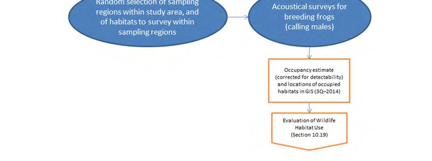
REVISED STUDY PLAN
disturb active nests. As soon as they are found, active eagle and other raptor nest sites will be
reported to AEA in order to develop avoidance zones for field studies.
Raptor migration point-count surveys will be conducted during April–May and September–
October in 2013 and 2014. Surveys will be conducted during peak periods of raptor migration in
spring and fall.
Field survey data will be used to update the geospatially referenced, relational database of
historical and current nest data in August 2013 and 2014, after occupancy and productivity
surveys have been completed. At that time, the most current delineation of suitable eagle and
raptor nesting habitat and the locations of active and inactive nest locations will be entered into
the database and proofed.
Roosting and staging surveys will be conducted between mid-October and early December in
2013 and 2014. Surveys will be conducted periodically to identify the use of winter foraging and
potential communal roost sites along the Susitna River. Four aerial surveys will be flown at
intervals of 2 to 3 weeks, depending on weather and the results of preceding surveys.
The Initial Study Report and Updated Study Reports will be completed within 1 and 2 years,
respectively, of FERC’s Study Plan Determination (February 1, 2013). The study reports will
include a summary of the study results to date. In addition, study updates will be presented at the
Technical Workgroup meetings, which will be held quarterly during 2013 and 2014.
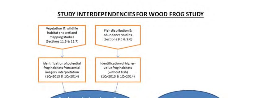
10.14.7. Relationship with Other Studies
Information from two other studies will provide useful input for planning surveys of eagles and
other raptors (Figure 10.14-2). Preliminary mapping of forested habitats from the Vegetation and
Wildlife Habitat Mapping Study in the Upper and Middle Susitna Basin (Section 11.5) will help
in survey planning for Bald Eagles and other tree-nesting raptors. Information on the location
and timing of late-season spawning runs of salmon from the studies of Fish Distribution and
Abundance in the Upper Susitna River (Section 9.5), Fish Distribution and Abundance in the
Middle and Lower Susitna River (Section 9.6), and the Salmon Escapement Study (Section 9.7)
will help in planning surveys of roosting and staging eagles in the fall and early winter. The
geospatial database of raptor nest locations will contribute directly to the Vegetation and
Wildlife Habitat Mapping Study in the Upper and Middle Susitna Basin (Section 11.5) and to the
Bat Distribution and Habitat Use study (Section 10.13) by identifying suitable cliff-nesting
habitats. Seasonal location and distribution data from the nest occupancy and productivity
surveys, roosting and staging surveys, and migration surveys will be used to identify high-value
wildlife habitat types for different raptor species in the Evaluation of Wildlife Habitat Use
(Section 10.19). Data on nest distribution, species abundance, and productivity, as well as data
on the numbers and flight paths of raptors during migration surveys of the transmission
corridors, will be used to inform the assessment of Project impacts in 2015 in the FERC License
Application and to help identify any potential PM&E measures, as appropriate. Feathers
collected from nests after the breeding season will provide samples to characterize pre-
construction levels of mercury in tissues of piscivorous raptors for the Mercury Assessment and
Potential for Bioaccumulation study (Section 5.7).
The primary impact mechanisms of the Project on raptors may include the following:
Susitna-Watana Hydroelectric Project Alaska Energy Authority
FERC Project No. 14241 Page 10-105 December 2012REVISED STUDY PLAN
Permanent direct and indirect habitat loss and alteration, including loss of nesting sites
and loss and alteration of foraging habitat.
Temporary direct and indirect habitat loss and alteration, including indirect impacts
resulting from altered distribution and abundance of prey.
Potential direct behavioral impacts, such as attraction or avoidance, resulting from
vehicular use, noise, and increased human presence associated with Project construction
or operation.
Potential indirect behavioral impacts to wildlife, such as attraction or avoidance, resulting
from changes in vehicular use, noise, and increased human presence associated with
increased subsistence or recreational access that may be facilitated by Project
development.
Potential direct mortality due to strikes with vehicles, power lines, towers, or other
Project facilities; exposure to contaminants; and attraction to garbage and human activity.
Any impacts associated with habitat loss and alteration, attraction and avoidance, and direct
mortality will occur primarily in the Project area, including the reservoir inundation zone, access
and transmission corridors, and other Project infrastructure. Impacts associated with altered
distribution and abundance of prey may occur over a larger area due to potential changes in both
competing mammalian predators and prey species abundance.
During the impact assessment that will be conducted in 2015 for the FERC License Application,
the impacts of direct and indirect habitat loss and alteration can be assessed through geospatial
analysis. When plotted on the wildlife habitat map, raptor nest location data will allow the
identification of high-value breeding habitats. Similarly, important habitats for prey species will
also be identified by the Evaluation of Wildlife Habitat Use (Section 10.19). Using GIS software,
the direct impacts of habitat loss can be evaluated for each raptor species by overlaying the
reservoir impoundment, related infrastructure areas, and access road and power transmission
corridors onto the wildlife habitat map prepared by the Vegetation and Wildlife Habitat Mapping
in the Upper and Middle Susitna Basin study (Section 11.5) to calculate loss of preferred
habitats. As was noted earlier, pertinent data from other studies will be incorporated into the
evaluation of potential Project-related impacts to eagles and other raptors. Indirect impacts of
habitat loss and alteration and behavioral reactions (such as avoidance) can be estimated by
applying various buffer distances, as determined from the literature on the effects of similar
projects, including responses of both raptor and their prey. In this way, the GIS analysis can be
combined with information from the literature to estimate the geographic extent, frequency,
duration, and magnitude of Project effects on raptor populations. Effects on the habitats of prey
species included in the Evaluation of Wildlife Habitat Use (Section 10.19) can be incorporated
into the impact assessment for raptors. Any necessary protection, mitigation, and enhancement
(PM&E) measures will be developed, as appropriate by examining the distribution and
abundance of raptor species and habitats in relation to the geographic extent and seasonal timing
of various Project activities.
Data collected for this study will allow calculation of the numbers of nests and territories that
will be lost per species per sub-area; the numbers of nests and territories otherwise affected per
sub-area; the type and level of impacts to forage and roost areas; the locations of any potential
collision hazard areas for migrating raptors; and other potential impacts, including large
increases in the availability of open water habitats created by the impoundment.
Susitna-Watana Hydroelectric Project Alaska Energy Authority
FERC Project No. 14241 Page 10-106 December 2012REVISED STUDY PLAN
10.14.8. Level of Effort and Cost
Occupancy/productivity for nesting raptors and fall and winter roost/forage surveys in 2013–
2014 will require an estimated 10–12 days of additional fieldwork beyond the 2012 surveys due
to the extended survey area for Golden Eagles. Therefore, costs for these surveys (including
helicopter time, analysis, and reporting) will be approximately $500,000 per year.
Transmission corridor surveys for migrating raptors in 2013–2014 will require approximately 30
field days, and estimated costs for these (with helicopter drop-offs, literature search, analysis,
and reporting) will be approximately $80,000 per year.
10.14.9. Literature Cited
ABR. 2011. Wildlife data-gap analysis for the proposed Susitna-Watana Hydroelectric Project.
Draft report, August 16, 2011. Report for the Alaska Energy Authority by ABR, Inc.—
Environmental Research & Services, Fairbanks, Alaska. 114 pp.
ADF&G (Alaska Department of Fish and Game). 2006. Our wealth maintained: A strategy for
conserving Alaska’s diverse wildlife and fish resources. Alaska Department of Fish and
Game, Juneau, Alaska. 842 pp.
AEA (Alaska Energy Authority). 2011. Pre-application document: Susitna-Watana Hydroelectric
Project, FERC Project No. 14241. December 29, 2011. Prepared for the Federal Energy
Regulatory Commission, Washington, D.C.
AEA. 2012. Surveys of eagles and other raptors for the Susitna–Watana Hydroelectric Project,
FERC Project No. 14241. Draft final version (March 26, 2012). Alaska Energy
Authority, Anchorage.
Anderson, D. E. 2007. Survey techniques. Pp 89-100 in: Raptor Research and Management
Techniques (D. Bird and K. Bildstein, eds.). Hancock House Publishers LTD, Surrey,
B.C. Canada. 463 pp.
APA (Alaska Power Authority). 1985. Before the Federal Energy Regulatory Commission: Draft
amended application for license for major project—Susitna Hydroelectric Project.
Volume 11, Exhibit E – Chapter 3: Fish, wildlife, and botanical resources. 702 pp. [APA
Doc. No. 3435]
APLIC (Avian Power Line Interaction Committee). 2006. Suggested practices for avian
protection on power lines: The state of the art in 2006. Edison Electric Institute, APLIC,
and the California Energy Commission, Washington, D.C., and Sacramento, CA.
APLIC and USFWS. 2005. Avian Protection Plan (APP) Guidelines. http://www.aplic.org/
mission.php
BLM (Bureau of Land Management). 2010. BLM–Alaska sensitive animal and plant lists.
Alaska State Office, Anchorage.
BPIFWG (Boreal Partners in Flight Working Group). 1999. Landbird conservation plan for
Alaska biogeographic regions. Version 1.0. U.S. Fish and Wildlife Service, Anchorage.
FERC and USFWS. 2011. Memorandum of Understanding between the Federal Energy
Regulatory Commission and the U.S. Department of the Interior United States Fish and
Susitna-Watana Hydroelectric Project Alaska Energy Authority
FERC Project No. 14241 Page 10-107 December 2012REVISED STUDY PLAN
Wildlife Service Regarding Implementation of Executive Order 13186, “Responsibilities
of Federal Agencies to protect Migratory Birds.” March 2011. 13 pp.
Kessel, B., S. O. MacDonald, D. D. Gibson, B. A. Cooper, and B. A. Anderson. 1982. Susitna
Hydroelectric Project environmental studies, Phase I final report – Subtask 7.11: Birds
and non-game mammals. Report prepared for the Alaska Power Authority by the
University of Alaska Museum, Fairbanks, and Terrestrial Environmental Specialists, Inc.,
Phoenix, New York. 149 pp. [APA Doc. Nol. 398.]
LGL. 1984. Susitna Hydroelectric Project: Update and refinement of Bald and Golden eagle
impact assessments and mitigation plans. Report for the Alaska Power Authority by LGL
Alaska Research Associates, Inc., Anchorage. 68 pp. [APA Doc. No. 2374]
Pagel, J. E., D. M. Whittington, and G. T. Allen. 2010. Interim Golden Eagle technical
guidance: Inventory and monitoring protocols and other recommendations in support of
eagle management and permit issuance. U.S. Fish and Wildlife Service, Division of
Migratory Bird Management, Washington, DC. 30 pp.
Pagel, J. E., and D. M. Whittington. 2011. Interim Golden Eagle Inventory and Monitoring
Protocols; and Other Recommendations: 2011. Presented at the Western Raptor
Symposium. J. L. Lincer and D. Bittner, co-chairs. Hosted by Wildlife Research Institute
and The Wildlife Society, Western Section. Riverside Convention Center, Riverside,
California. February 8–9, 2011.
USFWS (U.S. Fish and Wildlife Service). 2007. National Bald Eagle management guidelines.
Washington, DC. 25 pp.
USFWS. 2008. Birds of Conservation Concern, 2008. Division of Migratory Bird Management,
Arlington, Virginia. 85 pp. Available online (accessed November 2011) at:
http://www.fws.gov/migratorybirds/NewReportsPublications/SpecialTopics/BCC2008/B
CC2008.pdf
USFWS. 2009. 50 CFR Parts 13 and 22. Eagle permits; take necessary to protect interests in
particular localities; final rules. Federal Register 74: 46,836–46,879.
USFWS. 2011. Draft Eagle Conservation Plan Guidance. Available online at: http://
www.fws.gov/windenergy/eagle_guidance.html.
Wildman, A., and R. J. Ritchie. 2000. Synthesis of survey information on cliff-nesting raptors
and their habitats on the North Slope with emphasis on Peregrine Falcons in the Eastern
NPR-A and recommendations for survey needs. Report to U.S. Fish and Wildlife Service,
Northern Alaska Ecological Services, Fairbanks, by ABR, Inc.—Environmental Research
& Services, Fairbanks.
Susitna-Watana Hydroelectric Project Alaska Energy Authority
FERC Project No. 14241 Page 10-108 December 2012REVISED STUDY PLAN
10.14.10. Tables
Table 10.14-1. Raptors in the vicinity of the middle basin of the Susitna River (from Tables 4.6-2 and 4.8-2 in AEA 2011).
Conservation Seasonal Relative
Common Name Scientific Name
Status1 Status2 Abundance3
Bald Eagle Haliaeetus leucocephalus FS B uncommon
Boreal Owl Aegolius funereus PIF, FS R rare
Golden Eagle Aquila chrysaetos BLM, FS B fairly common
Great Gray Owl Strix nebulosa PIF, FS ? rare
Great-horned Owl Bubo virginianus FS R uncommon
Gyrfalcon Falco rusticolus PIF, FS R uncommon
Merlin Falco columbarius FS B uncommon
Northern Harrier Circus cyaneus FS B fairly common
Northern Goshawk Accipiter gentilis FS B uncommon
Northern Hawk Owl Surnia ulula FS R uncommon
Osprey Pandion haliaetus FS M rare
Peregrine Falcon Falco peregrinus anatum BCC, FS M unknown
Red-tailed Hawk Buteo jamaicensis FS B uncommon
Short-eared Owl Asio flammeus BLM, FS B?, M, S uncommon
Sharp-shinned Hawk Accipiter striatus FS B uncommon
Notes:
1 Conservation Status: FS = Featured Species (ADF&G 2006); BCC = Birds of Conservation Concern (USFWS 2008);
BLM = BLM Sensitive Species (BLM 2010); PIF = Boreal Partners in Flight Working Group (BPIFWG 1999).
2 Seasonal Status: M = migrant (transient); B = breeding; S = summering; R = resident; ? = uncertain (Kessel et al. 1982;
APA 1985: Appendices E5.3 and E6.3).
3 From Kessel et al. (1982) and APA (1985: Appendices E5.3 and E6.3).
Susitna-Watana Hydroelectric Project Alaska Energy Authority
FERC Project No. 14241 Page 10-109 December 2012REVISED STUDY PLAN
Table 10.14-2. Schedule for implementation of Surveys of Eagles and Other Raptors.
2012 2013 2014 2015
Activity
2Q 3Q 4Q 1Q 2Q 3Q 4Q 1Q 2Q 3Q 4Q 1Q
Aerial surveys for nest occupancy and
productivity assessments (2 surveys each)
Migration surveys (transmission corridors)
Update geospatial database of historical
and current nesting data
Update delineation of suitable nesting
habitat, old and active nest locations,
historical fall and winter roost locations
Conduct roosting and staging surveys
Initial Study Report Δ
Updated Study Report ▲
Legend:
Planned Activity
Δ Initial Study Report
▲ Updated Study Report
Susitna-Watana Hydroelectric Project Alaska Energy Authority
FERC Project No. 14241 Page 10-110 December 2012PROPOSED STUDY PLAN
10.14.11. Figures
Figure 10.14-1. Study area for Surveys of Eagles and Other Raptors.
Susitna-Watana Hydroelectric Project Alaska Energy Authority
FERC Project No. 14241 Page 10-111 December 2012PROPOSED STUDY PLAN
STUDY INTERDEPENDENCIES FOR SURVEYS OF EAGLES & OTHER RAPTORS
Vegetation & Wildlife Habitat Fish Distribution &
Mapping Study in the Upper Abundance Studies (Upper, Salmon Escapement Study
& Middle Susitna Basin Middle, Lower Susitna River) (Section 9.7)
(Section 11.5) (Sections 9.5 & 9.6)
Preliminary delineation of Locations of salmon
forested habitats for spawning runs
tree‐nesting species (especially late season)
(2Q–2013 & 2Q–2014) (4Q–2013 & 4Q–2014)
Nest Migration
Roosting &
occupancy & surveys
staging
productivity (transmission
surveys
surveys corridors)
Feather samples from Geodatabase of nest & Locations of fall and early Corridor‐specific migration
nests, plus synthesis of territory locations & winter staging areas & data (timing, species,
information on food habits success, by species, plus communal roosts numbers, flight directions)
and diets, of piscivorous mapping of suitable cliff‐ (4Q–2012, 4Q–2013, for transmission corridors
raptors (3Q–2013 & nesting habitat (3Q–2012, 4Q–2014) (4Q–2013 & 4Q–2014)
3Q–2014) 3Q–2013, 3Q–2014)
Mercury Assessment & Bat Distribution &
Potential for Habitat Use Study Evaluation of Wildlife
Bioaccumulation (Section 10.13) (cliff Habitat Use (Section 10.19)
(Section 5.7) habitat identification)
Figure 10.14-2. Study interdependencies for Surveys of Eagles and Other Raptors.
Susitna-Watana Hydroelectric Project Alaska Energy Authority
FERC Project No. 14241 Page 10-112 December 2012REVISED STUDY PLAN
10.15. Waterbird Migration, Breeding, and Habitat Use Study
10.15.1. General Description of the Proposed Study
The Waterbird Migration, Breeding, and Habitat Use Study will be conducted over two years
(2013 and 2014) and will include aerial surveys of water bodies during spring and fall migration,
a study of diurnal and nocturnal migration using visual and radar sampling, breeding-pair
surveys, stream surveys for Harlequin Ducks, and brood-rearing surveys. Waterbirds may use
lakes, ponds, rivers, and flooded wetland areas throughout the Project area to varying degrees
during spring and fall migration. Aerial surveys for staging and migration will follow a lake-to-
lake pattern and will also parallel river courses. The migration study will employ intensive
monitoring of migrating birds during both daytime and nighttime hours at a site located near the
proposed dam and associated camp infrastructure. Surveys of breeding waterbirds (primarily
waterfowl) will use a combination of full-coverage lake-to-lake surveys in most of the study area
and breeding-pair transect surveys in the easternmost portion of the study area. Aerial surveys
for Harlequin Ducks will focus on river and stream habitats during the pre-nesting and brood-
rearing seasons. Brood-rearing surveys will be conducted by surveying open water and shoreline
habitats of lakes and ponds in the study area.
Study Goals and Objectives
The goal of the Waterbird Migration, Breeding, and Habitat Use Study is to collect baseline data
on waterbirds migrating through and breeding in the Project area to enable assessment of the
potential impacts of the Project and to inform the development of appropriate protection,
mitigation, and enhancement measures. As used here, “waterbirds” is applied broadly to include
swans, geese, ducks, loons, grebes, cranes, cormorants, herons, gulls, and terns. Shorebirds
frequently are included in the general category of waterbirds, but they are addressed separately
for this Project under the Landbird and Shorebird Migration, Breeding, and Habitat Use Study
(Section 10.16) because the ground-based survey methods for shorebirds are similar to those
used for landbirds. This study plan includes breeding surveys for the Harlequin Duck, a species
of conservation concern that requires specific stream-survey techniques.
This study has three objectives:
Document the occurrence, distribution, abundance, habitat use, and seasonal timing of
waterbirds migrating through the Project area in spring and fall.
Document the occurrence, distribution, abundance, productivity, and habitat use of
waterbirds breeding in the Project area.
Review available information to characterize food habits and diets of piscivorous
waterbirds documented in the study area as background for the Mercury Assessment and
Potential for Bioaccumulation Study (Section 5.7).
The information gained from this study will be used to evaluate waterbird habitat loss and
alteration quantitatively, in conjunction with the separate Vegetation and Wildlife Habitat
Mapping Study and the Evaluation of Wildlife Habitat Use Study (see Sections 11.5 and 10.19,
respectively), and to estimate the number of migrating and breeding waterbirds that may be
affected by the Project.
Susitna-Watana Hydroelectric Project Alaska Energy Authority
FERC Project No. 14241 Page 10-113 December 2012REVISED STUDY PLAN
10.15.2. Existing Information and Need for Additional Information
Existing information on the distribution and abundance of waterbirds in the Project area during
the breeding and migration seasons is mostly based on studies conducted in 1980 and 1981 for
the Alaska Power Authority (APA) Susitna Hydroelectric Project (Kessel et al. 1982). Data from
those studies were used to quantify the level of use of water bodies by migrating and breeding
waterbirds. A relative “importance value” was determined for each water body surveyed in each
migration season, incorporating the number of species, the number of birds, and the density of
birds found on the water body in relation to the overall numbers and densities recorded on the
surveys (Kessel et al. 1982). Those study results provide a good knowledge base concerning
waterbird use of the Project area three decades ago; however, because the population numbers of
numerous species have changed in the past 30 years, new waterbird surveys are needed to
elucidate the current distribution and abundance of breeding and migrating waterbirds in the
Project area.
More recent survey data on breeding waterbirds in the upper Susitna River basin has been
collected annually during U.S. Fish and Wildlife Service (USFWS) waterfowl breeding
population surveys (Mallek and Groves 2011a), but only a few transects of the Stratum 2–
Nelchina survey area (Mallek and Groves 2011b) are located in the Project area. Those transects
occur east of the proposed reservoir near the Oshetna River, an area of low topographic relief
where the density of lakes, ponds, and wetlands is relatively high.
The population of Trumpeter Swans is an example of a waterbird species whose population has
changed substantially in the last 30 years (Conant et al. 2007). A complete census of Trumpeter
Swans on their breeding grounds in Alaska began in 1968 and was repeated at 5-year intervals
between 1975 and 2005 (Conant et al. 2007). Together, two survey areas (Unit 3–Gulkana and
Unit 5–Cook Inlet) include the entire Susitna River basin (Conant et al. 2007). The population of
Trumpeter Swans summering in Alaska has increased since 1975 and breeding has expanded into
peripheral habitat. No census was conducted in 2010, so information on the distribution and
abundance of Trumpeter Swans in the Project area is out of date and new surveys are needed.
Waterbird productivity was evaluated in 1981 using ground surveys of water bodies within
proposed impoundment areas and access routes associated with the APA Susitna Hydroelectric
Project. Those surveys provide historical data for the area 30 years ago, but need to be updated.
Current surveys addressing waterbird productivity need to be conducted in areas of proposed
facility locations, road and transmission corridors, and any areas affected by the Project within
and near the inundation zone.
No current information exists on the distribution and abundance of Harlequin Ducks in the
middle and upper Susitna River basin. The Harlequin Duck is a species of conservation concern
that nests and raises broods almost exclusively in mountain stream drainages. New surveys need
to be conducted to assess the distribution and abundance of Harlequin Ducks breeding in the
Project area.
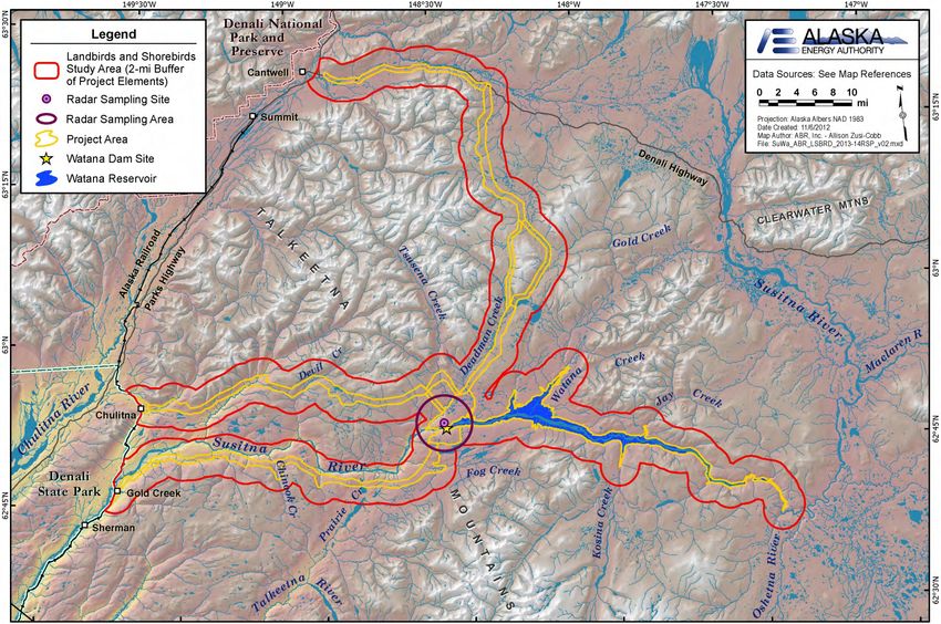
10.15.3. Study Area
The study area for waterbirds will encompass lakes, ponds, rivers, streams, and flooded wetlands
within a 3-mile buffer area around the Project area (Figure 10.15-1). The 3-mile buffer includes
nearly all of the 65 water bodies surveyed for the original APA Susitna Hydroelectric Project in
Susitna-Watana Hydroelectric Project Alaska Energy Authority
FERC Project No. 14241 Page 10-114 December 2012REVISED STUDY PLAN
the 1980s (Kessel et al. 1982), most of which occur in relatively discrete groupings (e.g., see Pre-
Application Document [PAD] Figure 4.6-16; AEA 2011). The study area boundary has been
extended farther than 3 miles in several places to include water bodies surveyed by Kessel et al.
(1982), such as Stephan Lake, Clarence Lake, and other unnamed water bodies south of the
Susitna River between Kosina Creek and the Oshetna River, but six large lakes surveyed
(Kessel’s numbers 131–136) between the mouths of the Tyone and Maclaren rivers will be
omitted because they are located well upstream from the area that may be affected by the Project.
Rather than specifying a minimum water body size to be surveyed for the lake-to-lake surveys,
the most efficient flight path through each water body group, and linking to other water body
groups, will be determined by an experienced waterbird biologist before the surveys begin, to
maximize the number of water bodies covered. That same route will be repeated on each
migration and breeding-pair survey using Global Positioning System (GPS) navigation; brood
surveys will concentrate on the subset of those water bodies located within 1 mile around the
locations and alignments of proposed Project infrastructure, including access road and
transmission corridors. The survey route will be developed by reviewing U.S. Geological Survey
(USGS) 1:63,360-scale topographic maps and high-resolution aerial or satellite imagery, as
available, and a GPS route file will be created for navigational use during the survey. It is
anticipated that all water bodies 2 hectares (5 acres) or more in size will be surveyed, as well as
many smaller ponds located between those larger water bodies. This approach will provide more
complete survey coverage than selecting a random sample from all water bodies in the study
area. All water bodies sampled will be entered into a Geographic Information System (GIS)
database to permit measurement of their area for use in calculating waterbird density.
All rivers and streams flowing through the study area buffer will be surveyed for breeding
Harlequin Ducks. These stream surveys will extend outside the 3-mile study-area buffer where
necessary to cover suitable habitats farther upstream. Habitat suitability will be evaluated during
the first pre-nesting survey for use in planning the three subsequent surveys.
A rectangular area has been delineated east of the upper end of the reservoir inundation zone
(“transect block” in Figure 10.5-1) in an area of low topographic relief with a high density of
water bodies. The transect block will be sampled during breeding-pair surveys using a transect
sampling approach, rather than attempting to cover all of the water bodies completely in a lake-
to-lake pattern.
10.15.4. Study Methods
10.15.4.1. Spring and Fall Migration
10.15.4.1.1. Aerial Surveys
Waterbirds use a broad range of lakes, ponds, rivers, and flooded wetlands throughout the
Project area during migration. The most effective means of assessing the distribution and
abundance of waterbirds over such a large area is aerial survey. Because of the distribution of
water bodies in relatively discrete, irregularly spaced groupings in most of the study area, a lake-
to-lake survey pattern is the most efficient survey approach, in which each lake is circled to
count waterbirds in the water and on the shore. Waterbirds often use rivers and streams for
staging during early spring when lakes are covered by ice, so surveys will be flown parallel to
river and stream courses.
Susitna-Watana Hydroelectric Project Alaska Energy Authority
FERC Project No. 14241 Page 10-115 December 2012REVISED STUDY PLAN Aerial surveys of waterbirds in Alaska typically are conducted using either a fixed-wing aircraft or a helicopter, with the choice of platform depending, in part, on the topography of the survey area. Because of the canyons and mountainous terrain in the Project area, a small piston helicopter (Robinson R-44) is the preferred waterbird survey platform to ensure good visibility, survey efficiency, and safety in maneuvering. To adequately characterize the period of migration and avoid missing migration peaks for various species of waterbirds, surveys will be conducted at 5-day intervals during the spring (late April to early June) and fall (mid-August to mid-October) migration periods, resulting in 10–11 surveys in spring and 13–14 surveys in fall, weather permitting. Each survey is expected to take approximately 2 days to complete. The spring migration surveys will transition directly into the breeding-pair surveys with no break in timing, as is described below (Section 10.15.4.2.1). A single, experienced observer will record all data on a hand-held digital recorder, which will be transcribed later into a computer database for analysis. Data will be summarized by species, species group, lake group or river segment, date of survey, and survey area. The survey results will be used to evaluate species composition and the timing of migration and to identify water bodies important to migrating waterbirds. Flight lines will be recorded on each survey using a GPS receiver. 10.15.4.1.2. Migration Study To acquire current information on the volume and flight directions of birds migrating through the study area, an intensive study of bird migration will be conducted using a combination of visual surveys and radar monitoring. The sampling site for the migration study will be established on the benchland just northeast of the proposed dam site, in the vicinity of the proposed Project camp. Although this study component is described here in the Waterbird Migration, Breeding, and Habitat Use Study plan, it is important to note that the sampling design will also provide data for the Landbird and Shorebird Migration, Breeding, and Habitat Use Study (Section 10.16). Diurnal visual observations will be conducted during daylight hours (sunrise to sundown) from late April to early June and from mid-August to mid-October. Using binoculars and spotting scopes, observers will record data along four visual transect lines (oriented in the cardinal directions—north, east, south, west) during 25-minute sampling sessions, separated by 5-minute break periods during which weather data will be recorded. Data recorded for each bird observation will include date, time, species (or taxon), flock size, transect crossed, distance crossed (distance from observer), flight direction, flight behavior, minimal flight-altitude category, and an estimate of actual minimal flight altitude. A portable marine radar that functions in both surveillance and vertical modes will be set up at the sampling site and will be powered by a portable generator. The radar (Furuno Model FR- 1510 MKIII; Furuno Electric Company, Nishinomiya, Japan) is a standard X-band marine radar transmitting at 9.410 GHz through a 2-m-long slotted wave guide (antenna) with a peak power output of 12 kW. The antenna has a beam width of 1.23° (horizontal) 25° (vertical) and a side lobe of 10–20°. Range accuracy is 1% of the maximal range of the scale in use or 30 m (whichever is greater) and bearing accuracy is 1°. This radar can be operated at a variety of ranges (0.5–133 km) and pulse lengths (0.07–1.0 sec). A pulse length of 0.07 sec will be used while operating at the 1.5-km range to sample the flight activity of small-bodied birds (e.g., songbirds). A longer pulse length (0.3 sec) will be used while operating at the 6-km range to Susitna-Watana Hydroelectric Project Alaska Energy Authority FERC Project No. 14241 Page 10-116 December 2012
You can also read