COASTWATCH AUTUMN 2015 SURVEY RESULTS ALL IRELAND
←
→
Page content transcription
If your browser does not render page correctly, please read the page content below
COASTWATCH
      AUTUMN 2015 SURVEY
           RESULTS
                   ALL IRELAND

                        1st DRAFT

  This is a draft of the Coastwatch Resutls 2015 and it is not a complete
                            version of the Report

            We apologize for possible mistakes or omissions

All picture acknowledgments will be included on the definitive version of
                             the Report.

                                     1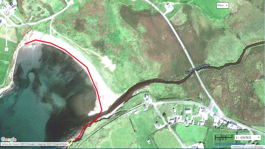
Acknowledgements
                                                Surveyors:

We would like to thank the over 1000 volunteers who participated in this 2015 survey and apologise that
we only list one contact surveyor, rather than all names in a group or school class. A similar big thank you
 goes to those, who surveyed but did not wish their name to be publicised and those whose data arrived
   too late to be included in this report. Your fieldwork and observations, handling of new online input
    forms, responses to requests for more information where you reported an unusual find and your
                    wonderful photos have made this survey report possible and special.

                                           Surveyor list overleaf

                                             Northern Ireland

  We are delighted to acknowledge our new Northern Ireland partners Ulster Wildlife and Dave Wall as
coordinator. A NI report drafted by the Ulster Wildlife team is being prepared and will be presented both
 as part of the All Ireland picture and separately at the international Coastwatch meeting in spring 2016.

                                          Regional Coordinators:

A special thanks to our RoI regional coordinators for their work, organising training events and surveying.
Listed in clockwise direction: Brendan Mc Sherry (Louth County Council), Declan Collins (Coastwatch
Meath), Michael Walshe (Coastwatch Fingal), Patrick Brady (Coastwatch Dublin with Dublin City Council
support), Rory Keatinge and Roselyn Shaw (Coastwatch Dun Laoghaire), Annie Falomo (National Sealife
Aquarium Wicklow), Karin Dubsky (Coastwatch Wexford), Bernie Connolly (Cork Environmental Forum)
and Aideen Kane, (Cork Nature Forum), Dr. David McCormick (Tralee Wetlands Centre - Kerry), Dr. Elaine
O'Riordan (Galway County Council), Anthony Brogan (Irish Wildlife Trust Mayo) and Lucy White, Rose
Kelly and Trish Murphy (Coastwatch Donegal).

               Coastwatch core team volunteers for this survey shared work as follows:
  Survey planning, pilot surveying, testing new questions, harbour questionnaire, training, paper return
                      data input, verifying results and developing a result exhibition:
             Karin Dubsky, Deborah Carlin, Roselyn Shaw, Michael Walsh, and Patrick Brady.

                      Social Media: Rana Rassouli (Facebook) and Conor Pyle (Web)

On-line Data Input programme, island coast digitising, survey progress map updates, results analyses and
                                     GIS mapping: Angel Duarte.

 Results Report by Karin Dubsky and Angel Duarte, in cooperation with Rory Keatinge and Keith Browne,
                       edits by Dr. Michael Gunn, Roselyn Shaw and Paul Dubsky.
                          Report Pictures by Coastwatchers as indicated in text.

 For this year’s focus on biodiversity and Dublin Biosphere Coast a special thanks to Niamh Ni Cholmain
                        and all in Dublin city and Dublin biosphere for their support.

                                               Sponsorship
We would like to thank the Dept of the Environment Water Section for core funding and acknowledge EC
funding under the FP7 Citclops project for new water colour and transparency app and training support.
 Benefit in kind was given by many, including all regional coordinators, with the Foyle ‘Celebrate Water!
       and Tralee Wetland Centre extending their help to hosting trainers and organising events.

                                                     2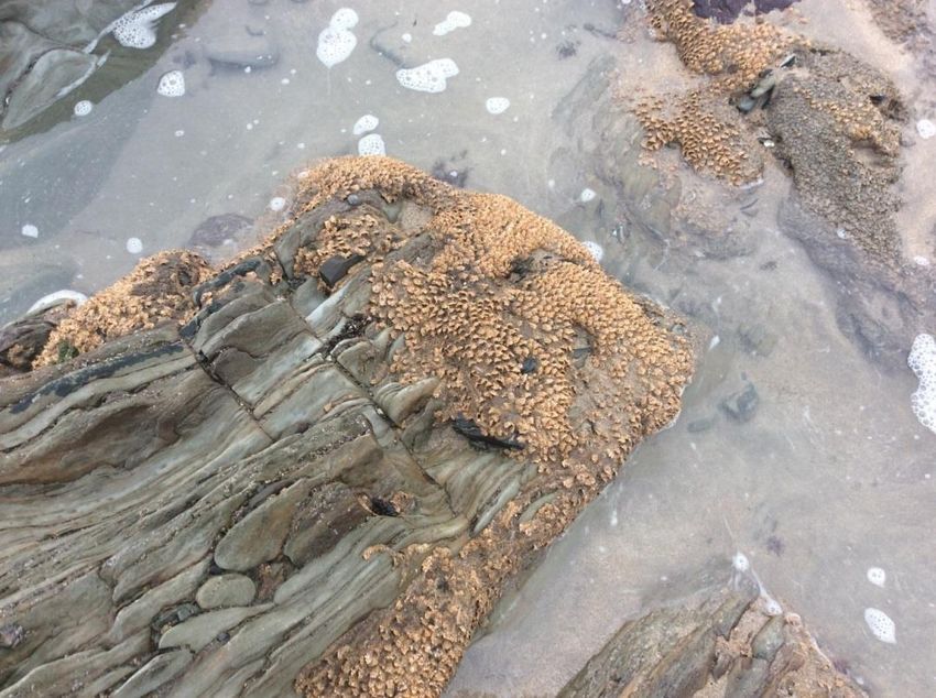
SURVEYOR LIST – COASTWATCH SURVEY 2015

Aine Walsh                                Emer Mc Loughlin                 Mary Elliot
Alan Walshe                               Enda Conneely                    Mary Looby
Alex Calder                               Enda O Cinnean                   Mary Mooney
Alexis Keating                            Finbarr Quigley                  Matt Wright
Andrew Bourke                             Finnian Mannix                   Michael Walsh
Andrew Cox                                Fiona O'Neill                    Mike Bloor
Angela O'Flynn                            Francois Gunning                 Mike McGovern
Ann Kelly                                 Galway Atlantaquaria             Newtown School
Anna Calder                               Gillian Todd                     Niamh Annie Bent
Annamary Maguire                          Glenarm Wildlife Group           Nicholas Mitchell
Anne Laird                                Helen Stuart                     Odhran
Annie Falomo                              HFWU Nueringen University        Oliver Franks
Annika Clements                           Hugh Livingston                  Olivia McCartan
Antoinette Kelso                          HWU Nürtingen Students           Paddy Houlihan
Aoife Stafford                            Irene Byrne                      Patricia Byrne
Aran Lafferty                             Irene Maison                     Patrick Brady
Asley Shak                                IRWC group                       Patrick Jackson
Barry O'Brien, Shay Horan                 Jacky Casserly                   Patrick Veale
Ben Monaghan                              Jacky Geary                      Paul Dubsky
Blackwater Tidy Towns                     Jacob Bouma                      Paul Hadland
Blennerville NS                           James Cosgrave                   Peta Taaffe
Breda Enright                             Jason Dunne                      Polly Dolan
Brian Black                               Jeanette Bloor                   Prince's Trust
Brian McMahon                             Jennifer Lynch                   Robert Galvin
Bríd O Hehir                              Jim Hurley                       Robin Hegarty
Brigid Fagan                              Joe Keatinge                     Robin Keating
Bunratty Search & Rescue Service          Joe Murphy                       Roger Da Silva
Cadogan Enright                           John Paul Geary                  Ron Adams
Calasanctius College Biodiversity group   John Walker                      Rory Keatinge
Caroline Quinn                            Jonathan Mason                   Roselyn Shaw
Cathleen Ní Chonghaile                    Julia Dubsky                     Roslyn Nicholson
Christian Küpfe                           Julia Zagar                      Ross Swift
Christian Küpfer                          Kaharine Duff                    Rowing Club (Donegal)
Christine Gibson                          Karin Dubsky                     Sarah Clear
Christine Loughlin                        Karolyn Cooper                   Science Camps - Gwy. Atlantaquaria
Ciaran Rapple                             Katriina Bent                    Sea Life Bray
Clare McMorrow                            Katy Bell                        Seamus o Lūing
Clare Murray                              Keara Robins                     Sharon Spratt
Coastwatch groups                         Keith Browne                     Shauna McMorrow
Conor Pyle                                Kevin Simpson                    Shay Daly
Cuan                                      Kiara Mulvey                     Shay Horan
Darach Ó Murchú                           Kilclief Residents Association   Skerries Community College
Dave Wall                                 Kimberley Harris                 Solenn Ni Dhonnabhain
David Healy                               Kristian Douglas                 Stephen M. Basteed
David McCormick                           Laila Higgins                    Sydney Woods
David Simmonds                            Larry - Celebrate the Water      Tamsin O'Brien
David Tilly                               Laura Wiggins                    Thomas Mulligan
Deborah Carlin                            Leilden O'Donoghue               Trish GoodBody
Diana Brown                               Lexi Keating                     Trish Murphy
Diana Doyle                               Linda O'Dwyer                    Trish O'Donoghue
Diane Orr                                 Love Your Lough Group            UCD Scuba Club
Douglas Taylor                            Lucy Keatinge                    Ulster Wildlife
Dylan Grey                                Lucy White                       Una Sealy
Eamon                                     Lynda Foy                        Victoria McEvoy
Edward Farren                             Maire O Brien                    VMware
Eilis Sheehy                              Margaret Somers                  West Coast Surf Club Members
Elizabeth Donnelly                        Mark Daly                        Willie Morrogh
Ellie Dunne                               Martha Keatinge                  Zoology Department TCD

                                                       3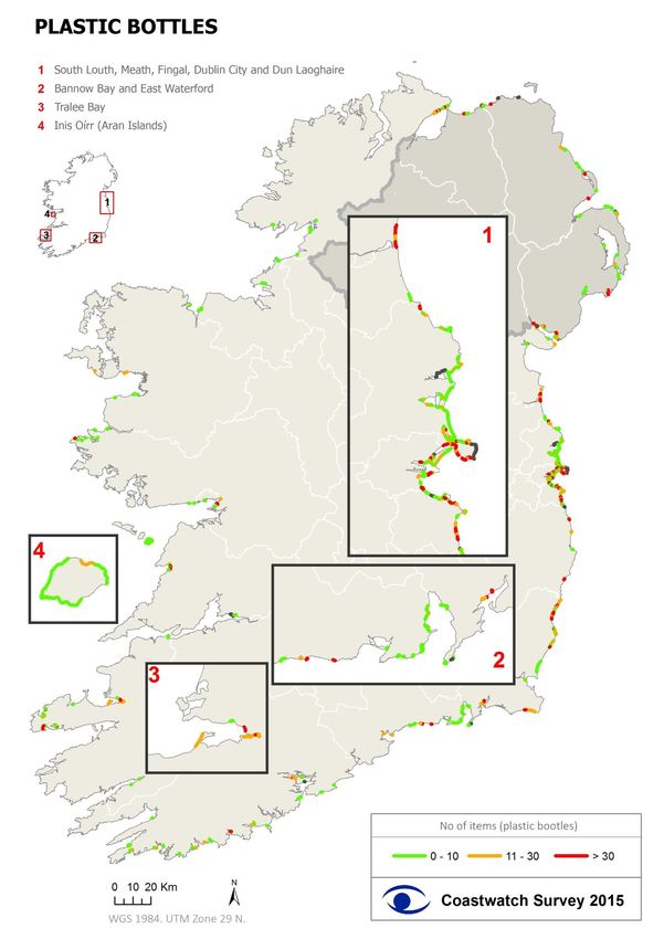
Contents
HISTORY OF COASTWATCH AND NETWORK AIMS ..........................................................................................5
EXECUTIVE SUMMARY OF IRISH SURVEY RESULTS .........................................................................................6
INTRODUCTION ...............................................................................................................................................9
METHODS ..................................................................................................................................................... 10
RESULTS PART 1: COAST SURVEYED AND ITS CHARACTER .......................................................................... 12
   Surveying and Coast surveyed ................................................................................................................. 12
   Shore Access ............................................................................................................................................. 15
   Hinterland................................................................................................................................................. 15
RESULTS PART 2: BIODIVERSITY ................................................................................................................... 16
   Habitats & Select Plants ........................................................................................................................... 17
       Manmade coast .................................................................................................................................... 17
       Habitats ................................................................................................................................................ 18
       ANIMALS ............................................................................................................................................... 31
       Invasive Alien Species ........................................................................................................................... 39
RESULTS PART 3: WASTE, LITTER AND POLLUTION...................................................................................... 41
   LARGE WASTE ........................................................................................................................................... 41
   2. LITTER COUNTS..................................................................................................................................... 43
   3. Small litter ............................................................................................................................................ 49
   4. Micro litter............................................................................................................................................ 51
   5. Looking back ......................................................................................................................................... 51
INFLOWS AND WATER QUALITY ................................................................................................................... 53
   Characterization of Inflows ...................................................................................................................... 53
   Water Quality Indicators .......................................................................................................................... 53
   Nitrates ..................................................................................................................................................... 54
   Views on sewage pollution incidents ....................................................................................................... 55
Threats.......................................................................................................................................................... 56

                                                                                 4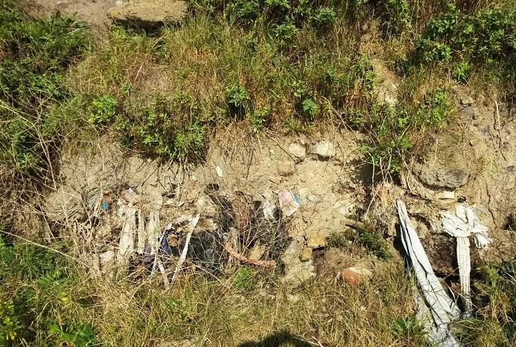
HISTORY OF COASTWATCH AND NETWORK AIMS
The Coastwatch Europe (CWE) survey was first designed and tried in Ireland in 1987 by the International
Co-ordinator, in cooperation with the Irish Times (national newspaper), With EC aid the survey method
was then disseminated to eight European countries in 1988. The first large scale survey was carried out
in 1989 in six countries: Norway, Denmark, Ireland, Netherlands, Portugal and the UK, and on a pilot scale
in four more: Iceland, Germany, Belgium and Italy. Participation grew in 1990 with Latvia, Spain and
Sweden joining. In 1991 the survey area was further increased with the inclusion of Greece, Estonia,
Lithuania and Poland. In 1992 France, Bulgaria, Ukraine and a corner of Finland were added and in 1993
Russia joined. In the same year, Japan brought 50 volunteers for training and then tried the project at
home. In 1996 Romania joined. It was the year in which international coordination handed out analyses
programmes to national teams to start reporting results at home and focus on follow up work to improve
matters on the ground – provide the coastal public with information and deal with democracy issues –
public participation in coastal zone management, planning and access to information. Several post
graduate including PhD projects developed including f. streptococci water pollution test kits. Coastwatch
was supported internationally by EC project funding to do joint training, data gathering and problem
solving follow up work. Depending on country and time, coordination is in the hands of solely volunteer,
to fully waged teams.

The survey is the common base project shared by the Coastwatch Europe network members. General
network aims put the role of the survey into context:

    1. Training and education of volunteers and students in fieldwork, basic reporting methods and
       relevance of shore quality and problem results obtained to policy and legislation (from local to
       national, EU and international conventions).

    2. Gathering baseline data about the European coast for use by local communities, authorities,
       governments, research organisations and NGO’s.

    3. Raising awareness of our coastal zone as a driver of European commons and as valuable shared
       resource, for which we have responsibility.

    4. Giving back up and expertise to members of the public, wanting to participate actively in coastal
       zone management (CZM), protective and remedial action.

With time the focus broadened from waste to natural environment and to linked social and human rights
issues. Lawyers joined national teams in several countries, so free legal and scientific aid could be
provided and significant development, specific waste law and product changes were achieved. As follow
up work grew, more extra national questions were added to the international survey questionnaire. The
network went through a local and national focus period. Coastwatch international coordination hosted
by Trinity College sought research funding and became partner in ‘Citclops’ EC FP7 funded research
project which brought a whole new perspective of interpretation water colour and transparency, algal
blooms and use of apps to record water colour with time and location on the web – the 2015 launched
Eyeonwater app. The Google Earth, GIS based and social media survey approach designed by our Spanish
volunteer researcher in Ireland proved successful and is now being used in Portugal, Spain, UK and
Ireland with pilot areas in other countries.

                                                    5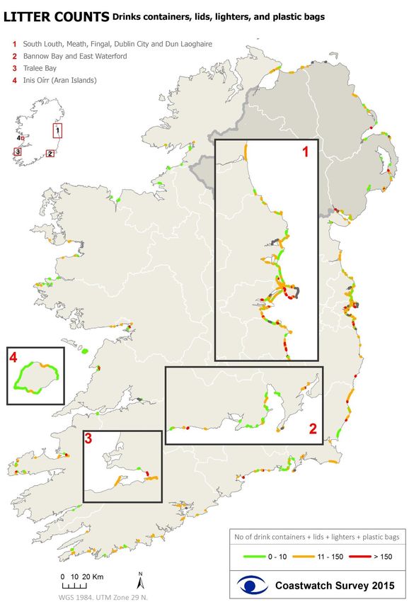
EXECUTIVE SUMMARY OF IRISH SURVEY RESULTS
Results for the island of Ireland Coastwatch 2015 shore survey are based on reports from >1000
volunteers reporting on just under 600 survey units (where 1 s.u. is ~ 500m shore length). After removal
of duplicates and inaccessible sites where only hinterland information was provided, 552 survey forms
were used in the report. This represents 3.6% of our 7900 km of island of Ireland coast as mapped by
Coastwatch. It includes some islands off the island of Ireland like Dalkey Island, Inis Oírr and Coney Island.
The survey yielded 81 from NI and 483 from the Republic.
Survey Method: Volunteers from all walks of life chose and booked their survey areas online, or through
regional coordinators. After preparing, they carried out a snapshot audit of their s.u. from hinterland
down to low water completing survey questions and water tests while on the shore. Results were
returned online or by post for input, clean up and analyses, then select results were mapped using GIS.
Timing: Sept 18th to Oct. 15th with extension until 31st Oct.
BIODIVERSITY
Dunes: important as natural erosion control, with specialised plants which trap more sand were reported
were mapped for the first time and overlaid on official NPWS data (2013). While some old dunes like
Portrane in Fingal have been eroded badly, 13 extra sites were found and verified. Some were old
established dune pockets, others neat new developing white dunes as in South Dublin Bay. Of concern is
that surveyors also reported sand mining at one of these sites - Baile An Reannaigh in Co Kerry.
Seagrass beds - both intertidal and the long Zostera marina - the edible forests of the sea - were reported
from 58 sites. In 32 of these the protected grass was found growing, in the rest surveyors noted Z marina
only swept up. This is a priority habitat and easily damaged by dredging, aquaculture and trampling.
Honeycomb worm Sabellaria reefs which like seagrass beds are very fragile and restricted in distribution
was reconfirmed on most established sites found in earlier Coastwatch surveys, except the inner most
Waterford estuary site at Woodstown. The Waterford estuary reef straggling the shore on both sides and
confirmed present beyond Anne’s town on the Waterford coast now. It will be studied in more detail in
2016 as it is likely to be one of the largest in Europe. These biogenic reef creations, are easy to miss when
you are walking the shore as the worms make them out of shore sand, but can look like cheddar cheese
on a toasty from the air.
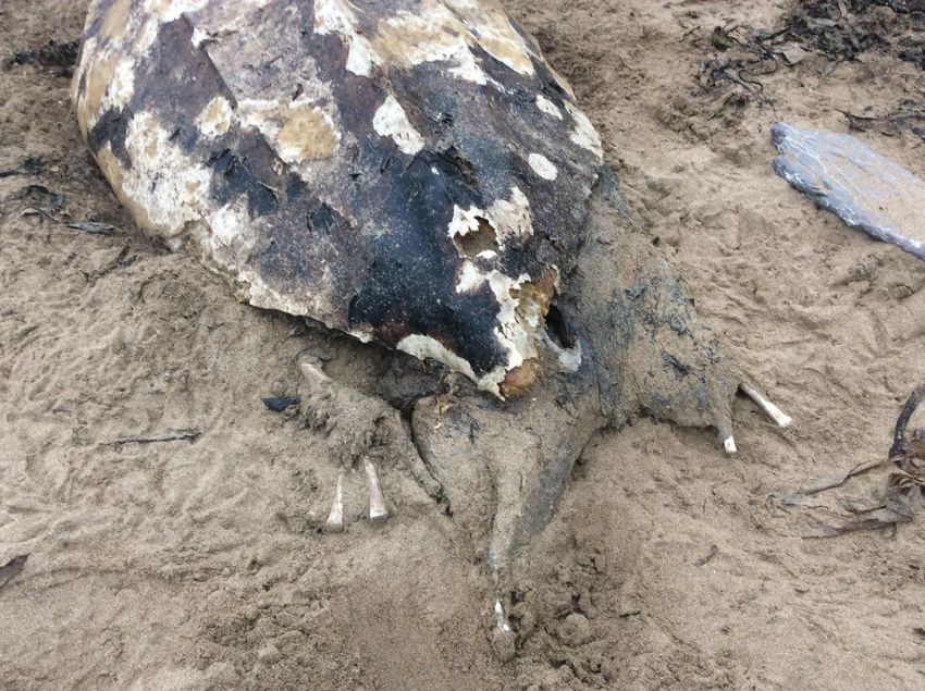
One hundred live seals were recorded dotted around our coast in 37 sites. Another 6 were found dead
one believed shot. Other dead animals included 2 headless leatherback turtles one in Morriscastle, North
Wexford and one in Ballybranigan Co Cork.
Birds were most widespread and numerous animal mentioned. Forty one dead birds were recorded most
on the East coast. Guillemots were named several times.
Shellfish are widespread as both empty shells and live animals. A seashell poster was prepared for the
Dublin area which has a high mollusc species diversity. The poster in English and Latin was translated into
Irish by Dublin city council and will be on the Coastwatch website for free download from Dec 15th.
The blue mussel was the most common shell found but old mussel beds are reported to be shrinking.
Limpets were the most common live mollusc reported and highlights the low oil pollution incidents on
our shores. Limpets were wiped out along most of the Dutch/Belgian/German North sea coast in the
1980s.
A group of students on Hook Head had a puzzling find of baby blue-rayed limpets on sea spaghetti –
prompting the question how the juveniles travel from there to the Kelp beds where the adults are found.
The Native Oyster Ostrea edulis whose shell halves were widespread as it once was a common shellfish,
is now very restricted in distribution and under threat. It was reported from Carlingford lough outside the
officially known range in a lough biodiversity hotspot. Surveyor photos and accounts, show it teaming
with tunicates, peacock worms displaying, huge diversity of molluscs and seagrass with flocks of
6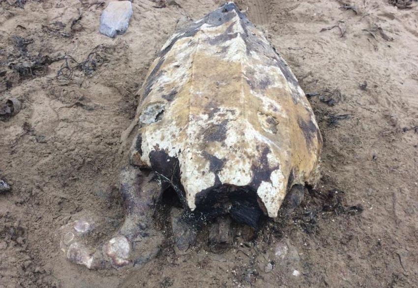
shorebirds feasting on them. On the downside surveyors noted active dredging for mussels which even
satellite image can show up. Dogwhelk Nucellus were mapped and found to be widely distributed. A
follow up harbour survey is planned with focussed search of this species as a TBT contamination
indicator.

Jellyfish: This autumn’s survey came after a cold water summer and yielded only 50 sites (9%) with
jellyfish, far less than in the 2 previous surveys (14% in 2014 and 20% in 2013).

CONCERNS
Invasive Alien Species Spartina grass was reported encroaching on open mudflat in Tralee bay and other
sites. Small patches were reported for the first time in the Dublin Bay biosphere at Merion gates where
seagrass and Salicornia are at risk if it spreads. New Zealand flax and Sea Buckthorn form large
monocultures straddling the splashzone, the latter especially in dunes. Japanese seaweed Sargassum
records came from a known site in Tramore Co Waterford and a new site at Bulloch harbour Dun
Laoghaire. The Pacific Oyster Crassostrea gigas. (or Gigas oyster) was previously reported by surveyors
growing on rocks in Lough Foyle and L Swilly (Donegal), Galway Bay (both Co Clare and Connemara end)
and in Clew Bay (Mayo). These are Natura 2000 sites with known invasive Gigas oyster record. During the
2015 survey Coastwatchers reported seeing then in new Carlingford North shore sites and on the Dingle
peninsula (not yet verified). There were several slipper limpet reports, one from a known Belfast lough
site, the others are still being verified.

Habitat Damage is like a sad literny where damaged sites reappear in successive surveys

Inappropriate erosion control wetland infill, vehicle tracks, bait digging without backfill and aquaculture
were the most widespread shore damage types noted. Most construction waste dumping as erosion
control such as at Dublin’s Ringsend Nature Park is historic rather than recent, but that still requires
attention and in follow up work Coastwatchers have explored options with more secure erosion control,
natural look and biodiversity enhancement. In Youghal a wetland behind seabank between old landfill
and harbour has received more waste and in Co Clare an infilled wetland North of Lahinch will hopefully
soon be restored as infill was found to be illegal. In Bray, the old closed dump is still falling into the sea.
Aquaculture installations were reported to now extend along approx. 15 km of shore on the Donegal side
of the lough. These are unlicensed and causing visible seafloor damage as well as increasing the risk of
further Gigas oyster settlements.

WASTE AND LITTER
Waste and marine litter were reported from large down to micro level with some items counted, others
just recorded as present or absent. Select results are expressed as potential indicators for the new marine
law (MSFD) Litter Descriptor, also exploring what ‘Good Environmental status’ may be.
Tyres were reported on 23% of the coast and are now the most wide spread large litter type. While most
counts provided are for 1-4 tyres, large clusters are associated with tyre traps to catch peeler crabs.

A cluster of bicycle tyre litter in the splashzone near Warren point was reported and thought to arise
from tyre changes on adjacent cycler rest and car park.
Landfill material– the make shift erosion control and convenient waste disposal option was noted in 1
out of 5 sites and household furnishings in 14%. Household refuse in bags or sacks was reported in 7% of
surveyed areas.
When drinks containers, lids, lighters and plastic bags were mapped, the highest litter density was on the
Irish sea coast and most but not all associated with rivers and towns.
Drinks container litter was the most widespread litter encountered and increased over 2014 as more
urban shores were included in this year’s survey. Plastic bottles were noted in 83% of s.u. in keeping with
previous years and 14415 plastic bottles were counted. This is now expressed in new OSPAR compatible
100m averages as 3.9 bottles/100 m of shore. Surveyors also counted 5 726 cans distributed over 68% of
shores (2.4/100 m). This count is less accurate as can body metal now dissolves quickly and grey metal
                                                      7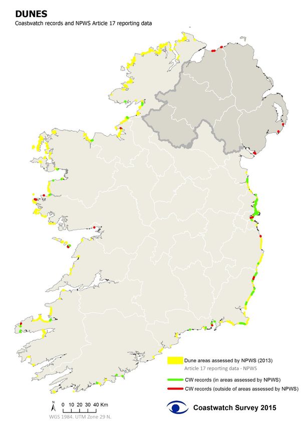
pieces are easy to overlook. The 1341 or 0.5/100m glass bottles were distributed over 45% of sites. Tetra
pack containers remain least frequent with 41% of sites reporting this litter and a count of 1057
averaging 0.4/100m. A new bottle lid count introduced this year yielded 2876 dispersed over half of all
survey sites.

There were one or more plastic shopping bags in 46% of survey units. The count of 1240 came to an
average of 0.5/100 within the same low count range as in previous years. The NI count of 302 bags came
to 0.8/100m which is a little higher than in the south.

Mapping surveyor reports of small litter seen, shows that after plastic bottles and cans, the ‘rope and
string’ category was the most widespread litter (64% of shores), followed by ‘other plastics’ (60%) , textile
(56%) bottle lids (50%), hard plastic containers (46%) and polystyrene (43%).

The combined category of fishing/angling/aquaculture gear was found on 38% of shores and dominated
by net pieces. Other litter of note mentioned were balloons and cotton buds.
Surveyors reported seeing visible lines or patches of micro litter on 27% of shores. While samples were
not analysed notes of seeing hard plastic pellets and polystyrene beads, fibres and paint flecks were the
most frequently mentioned.

INFLOWS
Stream, drain and piped discharge quality was similar to 2014 where most surveys took place before
autumn rains started, which would tend to improve nitrate readings. The 432 inflows recorded in 216 su.
207 of these were tested for nitrates.
Nitrate tests carried out by surveyors on 207 inflows, showed that 35% nitrate levels were below
detection by our field test method (10 mg/l threshold) and 31% below 25mg/l. But 34% were above
25mg/l and of these 24 breached the legal 50mg/l NO3 limit which is dis-improvement over the previous
year. As observed in the past the high nutrient inputs are in one horticulture area of Fingal and then
mainly distributed over the SE and S coast.
68% of survey sites were described as never or very rarely effected by sewage. Discolor scum and froth
were reported on 12%, a bad smell was noted for 7%. In or along the banks of 2 % invasive alien species
were recorded and similar numbers had visual signs of sewage or sewage fungus. In 4 cases inflows were
reported to carry oil.

BACKGROUND INFORMATION AND SURVEYOR CONCERNS
Shore cleaning in the week before the survey was sought to have taken place on 10% of shores the
second highest on record. Breaking that down it was 9% in the Republic and 14% in the North. Shore
cleaning has increased steadily from 1-2% in the 1990s, to 4% in 2012 and now 10 to 12%.
Surveyors who reported threats to the shore mentioned erosion most frequently as in all previous years.
This was followed by water pollution, with recreational abuse in third place and invasive alien species in
fourth.
Aquaculture which ranks highest in some west and north coast locations was low due to less surveying in
this area. The threat of construction in the coastal zone is still well down from peak Celtic tiger days.

Mapping the 131 threat of erosion sites shows threats were all noted in the republic and most were
south of a line from Fingal to Galway bay. In 52 of those some sort of erosion control was recorded. In
another 170 sites hard erosion control was also recorded but evidently trusted sufficiently to not report
erosion as an imminent threat.
The report is illustrated with over 50 maps and graphics, some look at findings over several years. Over
the last 3 years, Coastwatchers have surveyed 1267 individual survey sites (8% of the irish coasts mapped
by Coastwatch), 115 of these were surveyed every year (2013, 2014 and 2015), 220 were covered in two
of the three years and 932 only once.

                                                     8
INTRODUCTION
The 2015 Coastwatch survey marks 28 years since the survey was designed and run first with the Irish
Times (1987). While the basic surveying – a set area around low tide – has remained the same, today’s
technology with online maps for survey site mapping and choice, Facebook as information channel and
the online survey data input option have dramatically changed how we engage and has created
opportunities for comparing and contributing valuable extra information to official monitoring schemes
and results display.

The All Ireland results in this December report are presented as a draft. Some results are still being
verified. We would be very pleased to receive comments and corrections to improve the final report to
be published in February 2016 and presented in March when other parts of Europe are ready.

The All Ireland survey ran from Sept 15th to Oct 15th, with further reports accepted until the end of the
month. Results covering 564 survey sites are being launched on Dec 14th by the Ardmhéara/Lord Mayor of
Dublin Críona Ní Dhálaigh. The event also included a half day Marine law (MSFD) workshop on the
programme of measures to bring our seas to ‘Good Environmental Status’ by 2020.

The survey carried out by volunteers assesses the coast in 500 m survey units, with information gathered
then pooled and mapped. Apart from factual reports on various animals, plants, types of litter, there are
also personal views sought about the coast surveyed.

Figure 1Leatherback turtle found in Ballycronin by Mary Loby.

                                                                9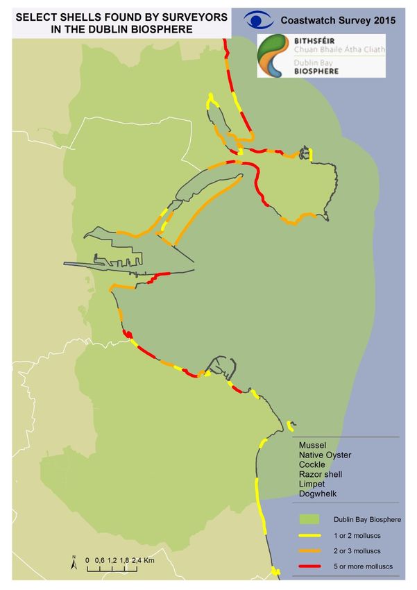
METHODS
The Coastwatch Survey is carried out by members of the public. It involves walking a chosen piece of
coast once around low tide. The surveyors are asked to fill in a questionnaire for each survey site,
designed to give an overview of the state of the coast – see www.coastwatch.org

A survey site or survey unit (s.u.) is a stretch of shore approximately 500m long as measured along mean
high tide mark. The width covers the sea shore from start of the hinterland down to shallow water at low
tide. Four years ago the coastline which had been divided into 500 metre units by hand was re-digitised
using GIS, improving the accuracy. As in previous years each coastal unit was given a unique code based
on the EC NUTCODE system, with counties numbered in clockwise direction, a further numerical codes for
the 5 km blocks within each county and finally the 10 units within each block. Island around Ireland were
only digitised on request.

Surveyors go line bit.do/cwsurveyunits bring up the map with blue and white survey units, zoom in and
click on a chosen s.u. which then brings up the survey area code to be copied onto the survey
questionnaire. Most volunteers now photograph that map with their smart phone so they can look at it
and zoom in on features when out in the field.

Those who do not have online facilities are helped by regional or national coordinators by sending them
hard copies of survey forms and of an area to survey discussed over the phone or in training session.

Materials

The materials for the Coastwatch Survey 2012 were available online, or distributed through the regional
coordinators by post on request.

   -   Survey questionnaire 2015: available online and in hardcopy, with a biodiversity poster for
       species identification.
   -   Survey Guide notes: also available online, with detailed instructions to participate in the survey
       and indications on how to fill in the questionnaire. Further instructions on how to find a survey
       site or how to share photos and videos were also available online.
   -   Water quality test kits: Nitrite/nitrate tests with colour charts were distributed by the
       coordinators and posted to surveyors on request, as well as demonstrated and handed out in
       training sessions.
   -   A Harbour survey form and instructions to download an app ‘Eyeonwater’, to use when
       surveying the deeper water around harbours and piers.

Booking areas and monitoring progress

To book a survey site surveyors filled out an online booking form (now closed) This information was then
used to update the online map and colour code booked areas yelllow so others would not duplicate the
                                                   10
effort. As this step was done manually there was still a lag of up to 48 hours between booking map
updates. As the survey progressed and data was returned, the online map also showed areas which were
surveyed and data entered into the results database.
Coordination and communication
Regional coordinators were engaged again as volunteers in most counties. Their main tasks was to
answer surveyor questions, to allocate survey sites, to coordinate groups and to distribute materials.
Some also carried out training for new surveyors and did extensive survey work.
The surveyors were targeted through the existing network from previous surveys, some national and
regional media and this year specially focusing on social media. Where possible training sessions were
provided to groups and individual surveyors.
Data compilation and analysis
The surveyors were given two options to return the completed questionnaires. The first option was to
enter the data directly on the online input form on the Coastwatch website. The second option was to
post hard copies of results. In this case the data was entered using the same input form by Coastwatch
volunteers in Trinity College Dublin.
After the data was inputted it was transformed into a spreadsheet to be checked and analysed. If there
were questionnaires with missing information, missing locations or any doubt about the data the
surveyors were contacted. In the case of any inaccessible sites only Section A of the questionnaire is filled
in. For the rest of the sections these data sets are omitted from the analysis.
Verification
Special information like new seagrass bed locations or beaching of large animals was also followed up and
photos sought. Where possible the special finds were also verified by an experienced Coastwatcher and
advice given who else to contact or any follow up work where needed.
11RESULTS PART 1: COAST SURVEYED AND ITS CHARACTER
Surveying and Coast surveyed
Surveyors are asked to state the date on which they carried out their Coastwatch shore audit. As
figure 1 below shows surveying began just before the official survey start which was data collected in
training sessions, then building up to a steady 10+-3 sites until end of October, There were three
peaks of > 20 survey sites/day of which one on October 9th was greater than 50.
The first serious technology upset was experienced since changing to online methods as the
Coastwatch website went down on day 1 of the survey for 3 days, so no one could book or get
information. This also cost us the television feature coverage which had been planned and the usual
new surveyor surge national media publicity brings in the Republic. In the North the new coordinator
started almost from scratch as the previous ecology group which had done most surveys had
dissolved.
60
50
Spring Tides
Spring Tides
Spring Tides
Spring Tides
No of survey units
40
30
20
10
0
9-Sep
3-Sep
5-Sep
7-Sep
2-Nov
4-Nov
11-Sep
13-Sep
15-Sep
17-Sep
19-Sep
21-Sep
23-Sep
25-Sep
27-Sep
29-Sep
1-Oct
3-Oct
5-Oct
7-Oct
9-Oct
11-Oct
13-Oct
15-Oct
17-Oct
19-Oct
21-Oct
23-Oct
25-Oct
27-Oct
29-Oct
31-Oct
Date of survey
Figure 2 Survey fieldwork over time expressed as number of survey units done per day ( Coastwatch survey 2015)
Bearing all this in mind the results include more established surveyors and despite a slight decrease
in survey reports an increase in school groups and recreational interest groups like surfers, diving
clubs and youth groups. Many of these joined as individuals or pair surveyors last year, but brought
their group in this year. Another difference noted was the detail in biodiversity question responses
and hence extra information gathered.
The total number of units surveyed in 2015 was 564 (81 in Northern Ireland and 483 in the Republic
of Ireland). Of these, 12 were inaccessible (11 where access was impossible and 1 where access was
prohibited) and are only used for the analysis of Section A. This accounts to 282 km of the Irish
shoreline (3,6% of the coastline mapped by Coastwatch).
12Map 1 – Coast covered in 2015 Coastwatch Survey.
The most surveys - see Figure 1 - were carried out along the Dublin Fingal coast (109 s.u.) , this was
followed by Wexford (73) and County Down NI (52). Of the other counties Cork saw a good increase
over last year (39su) and Kerry held its own with 37 sites. There were 32 s.u. included from
Waterford and 10 too late for inclusion in results analysis. County Galway ranked next with 29 sites,
closely followed by Dun Laoghaire and Donegal. Louth, Clare, Antrim, Sligo, Derry and Wicklow all
covered more than 10 survey sites. Smaller than usual contributions came from Mayo, Galway city
and county Meath. Limerick and Leitrim unfortunately did not return any surveys.
Fingal
Wexford
Down
Cork
Kerry
Dublin City
Waterford
Galway County
Dun Laoghaire
Donegal
Louth
Clare
Antrim
Sligo
Derry/Londonderry
Wicklow
Mayo
Galway City
Meath
0 10 20 30 40 50 60 70 80 90 100 110
No of survey units
Figure 3 Number of survey units included in the 2015 Coastwatch survey (Dec 2015 Coastwatch report) by county, separating
Ireland North and South by colour.
13When expressed as percentage of coast surveyed, then the Dublin region had by far the highest
coverage. With UNESCO confirmation of the new Dublin biosphere reserve boundaries to stretch
from Portrane to Shankhill, Dublin biosphere partners supported training events and display of
survey materials resulting in the highest coverage of this area ever achieved.
Dun Laoghaire
Fingal
Dublin City
Wexford
Meath
Wicklow
Waterford
Louth
Down
Derry/Londonderry
Sligo
Antrim
Kerry
Clare
Galway County
Galway City
Cork
Donegal
Mayo
0 5 10 15 20 25 30 35 40 45
% of coast covered
Figure 2 Percentage of coast covered in the 2015 Coastwatch survey by county, separating Ireland North and South by colour.
(Dec 2015 Coastwatch report)
Over the last 3 autumn survey periods, Coastwatchers have surveyed 1267 individual survey sites, 115 of
which were surveyed every year (2013, 2014 and 2015), 220 were covered in two of the three years and
932 only once.
Map XX – Left: 115 survey units covered every year since 2013. Right: 1267 survey units covered in any of the last three years.
14Shore Access
Most shores surveyed were accessible by foot, for 30% there was also vehicle access. In 20% it was
difficult to access the chosen survey unit directly from the hinterland of that survey unit and one had to
approach via an adjacent survey unit. In 10 sites the access was impossible from land. These survey units
were later excluded from the analyses for animals/plants, marine litter and inflows.
Wheelchair access right to high water mark was indicated as possible in 14%of sites. This may well be an
over estimate according to wheelchair users as many wheelchairs do not have wheels suitable for
traversing even hard sand splashzone entries. As we were also made aware that accurate wheelchair
access information is missing for almost all of our coast, a rephrasing of this question and guidelines
written by wheelchair users is being considered.
By foot
By vehicle
Access is difficult/impossible
By wheelchair
Access is prohibited
0 10 20 30 40 50 60 70 80 90
% of survey units
Surveyors were asked in question B1 to describe what the hinterland of their survey unit was mainly
devoted to. They could tick up to 4 options in case of mixed use.
In the 2015 results transport and village or residential areas were part or all of most survey unit - see
graph below.
Hinterland
Transport (road, train, port…)
Village or town residential
Farmland: Rough grazing
Other hinterland
Dunes
Rock or bare natural sediment
Farmland: Intensive grazing
Park, woodland, forest
Tourist resort
Farmland: Tillage, horticulture
Wetland (bog, marsh, lagoon)
Industry/commercial area/power station
Waste tip/dump
Construction site
0 5 10 15 20 25 30 35 40
% of survey units
15RESULTS PART 2: BIODIVERSITY
Overall, biodiversity loss and the degradation of ecosystem services in the EU have continued since the
EU 2010 biodiversity baseline, as confirmed by the 2015 European environment - state and outlook report
Reference: http://www.eea.europa.eu/soer
Oblivious to the shore’s rich
There is lots of life on the shores and shallow waters around the island of Ireland. Some is obvious, like
big brown seaweeds and the Chinese hat like limpets stuck tightly onto rocks, thousands of wintering
seabirds crowding our bays looking for food and shelter. We also note a seal’s head popping up and
occasional sightings of cetaceans. Most of our sea life though – even life we walk across when the tide is
out – goes unnoticed. If presence is not known, how can absence be missed? And if people do not know
how fragile some shore life is, they will not take care with activities which may damage it given the
acknowledged continued biodiversity loss in the world today (European Environment Report 2015
http://ec.europa.eu/environment/nature/biodiversity/comm2006/pdf/mid_term_review_summary.pdf)
and the UN Biodiversity Convention’s firm targets of halting the loss of biodiversity, this lack of awareness
and knowledge needs to be addressed.
So aim 1 of the Coastwatch biodiversity questions is to raise awareness, open eyes and train people
where to look for the riches, when and how to avoid damage and disturbance.
Aim 2 is to contribute to scientific knowledge. With a marine area 10 times that of land and over 7000
km of All Ireland shore, the official marine scientist work just has to be selective. We still have far too
little scientific information about the majority of our ocean wealth including the rich coastal rim. More
than 500 shellfish aquaculture license applications in protected sites are pending - the majority as the
marine information to assess impacts is incomplete. There are inshore areas of particular value as highly
productively areas, nursery and spawning grounds which we know surprisingly little about:
- The strip exposed at spring low tide which is too shallow for most marine research vessel work
and too deep for most intertidal surveys.
- Sheltered bay and estuary shore and splash zone retreats with little tidal channels, saltmarshes
and reed beds which can be awkward to access.
These areas and the recording of fleeting finds anywhere - a beached sea turtle, mass death of organisms,
or an algal bloom - are perhaps the most important citizen science marine biodiversity knowledge
contributions which Coastwatchers can make. This aim is aided by training as we were able to give,
supported ted by the Department of Environment Water Services grant and by new technology as
developed in the EC funded FP7 ‘Citclops’ project in which TCD/Coastwatch was the Irish partner and
many Coastwatchers helped to test over the last 2 years, resulting in the Eyeonwater app. Once
downloaded and tested on the phone, it should enable anyone to record red tides, dredge plumes or
indeed occasions of beautiful water colour and transparency and have that information uploaded with
location and time as evidence and as scientific data.
Aim 3 is to help active citizen engagement in informed decision making– a personal decision not to drive
over an intertidal Seagrass bed once you know that it’s there, a decision not to have your dog chasing
wintering birds although he loves it and you love the sight. A second part of our aim is more challenging –
help coastwatchers make an informed contribution to teaching or a planning application, or input into
consultations like the Programme of Measures to bring our seas to Good Environmental Status (GES)
under the Marine Strategy Directive. While the first example above just requires knowledge of something
fragile and valuable to inform personal behaviour, the other examples also require an understanding of
language, legal and planning context which our formal education from primary to tertiary is lacking.
16Habitats & Select Plants
In Question D3 surveyors were asked to describe the splash zone habitats in their 500m s.u. As the survey
is aimed at the general public the core international survey form only includes a selection of habitats,
groups of algae, plants and animals (Section C and D of the survey form). Optional extra species and local
harvesting knowledge is being sought on the back page of the Irish and UK survey form, with same
questions now also adopted for N Spain and Portugal.
Most surveyors reported that there were several habitat types present, with sand/gravel/stone reported
most frequently from the splashzone of 58% survey units.
Manmade coast
Hard erosion control was recorded in 39% of survey units – see map XX The occurrence is higher than in
previous years due to the overrepresentation of the Dublin coast and due to the gradual increase in hard
erosion control around our shores which was commented upon by several surveyors. Buildings and
construction which had another function rather than erosion control - usually a pier, harbour or slipway
were present in 10% of survey sites.
Soft erosion control like earth banks were noted in only 8% of surveyed sites. From training sessions we
suspect that well grassed man made sea field embankments are often recorded as ‘other’ rather than
manmade soft erosion control. ‘Other’ which was noted in 20% of survey sites and also includes the
natural boulder clay sea banks of the SE coast which slip and slump when the base is undermined by the
sea.
Map XX- Manmade hard and soft erosion control present over all or part of a survey unit: Hard – wall,
rock armour, gabions and soft – usually earth banks.
17Natural rock was the third most common coast type recorded and found in 36% of survey units. That
includes rocky outcrops on sandy shores and full rock coasts with sea cliffs.
Sand, gravel, stones
Hard erosion control (walls, rock armour)
Natural rock/boulder
Dune
Cliff
Other plant cover habitat
Building, construction (not erosion control)
Saltmarsh
Soft erosion control (e.g. bank)
Reed bed
0 10 20 30 40 50 60
% of survey units
Figure XX: Spashzone habitats reported in the 2015 coastwatch survey.
Three soft coast types Dune, Reed beds and Saltmarsh were included in the survey and results will be
looked at in more detail over the next few months as high value habitats under pressure and susceptible
to climate change effects.
For this report December 2015 dune and seagrass survey results were picked as first habitats to
investigate in relation to official monitoring and to explore how this type of citizen science work might be
integrated and benefit coastal monitoring and protection.
Habitats
Dunes
Dune habitats were reported from 133 (24%) surveyed shore units. In 43 (32%) of these surveyors also
indicated they saw an imminent risk or threat of erosion. In some known old dune sites, lichen rich sods
of grey dune were seen strewn across the shore as in Kilmichael Co. Wexford. In Mullagmore Co Sligo a
layer of peat bog was protruding underneath the dune and to underline how close bog and dune are, a
duneslack in the centre of this large system sports a large patch of bog cotton Eriophorum vaginatum
normally associated with blanket bog.
Even in an exceptionally mild calm autumn before any winter storms many old dune stocks are under
erosion pressure.
Now focussing on dunes around the Republic of Ireland, we overlaid Coastwatch reports of dune in the
immediate hinterland and/or splashzone on the latest NPWS dune habitat maps (Article 17 reporting
data, 2013) map XX. This confirms that Coastwatch surveys which were carried out in areas officially
recorded as dune, were generally reported as dune – although there were exceptions as in Dublin bay
around Sutton dinghy club and south of Sutton cross where the dune fringe is now so small that it was
discounted and at Ballyconniger Co. Wexford where the dune has now eroded and all that is left is a
row of rock armour which was once put at the foot of the dune and a sand cliff with farm grassland and
caravan park hinterland - see photos below/
18More excitingly Coastwatchers also recorded dune vegetation outside the official sites. Before
verification work was carried out on these reports outside the NPWS sites, we assumed they were recent
embryonic dune pockets, but there were also sites which were considered established dunes among
them.
19Map XX: Dunes around the Republic of Ireland – Comparison between CW records and areas assessed by
NPWS.
20A narrow band of dune may build for a few years from drift line to white dune to vegetated dune and
then get washed away in a winter storm. However that cycle tends to repeat itself in the same area. One
may argue it’s not worth including such transient sites in a dune inventory. However as so many of our
old dunes have little or no embryonic dune front and open, mobile sand is an essential habitat
requirement for some dune plants, like the now possibly extinct Sea Stock, it may be more prudent to
record these when we come across them. Indeed one can see this policy was adopted for some sites. IN
the 2004-6 coastal monitoring project carried out on behalf of NPWS www.npws.ie/sites/.../
Ryle_et_al_2009_Coastal_Monitoring_Project.pdf Bull Island was marked in the data base as the only
dune. In the 2013 NPWS survey, the embryonic dune at Sutton and at Merion gates/Booterstown was
added (see figXX below) This year our surveyor group recorded a doubling of this white dune rim length
around the ’baby lagoon with Salicornia band’. The extra interest here is that a rare Salicornia sub-type
community – Sagino maritimae-Cochlearietum danicae, which is confined to a narrow band between the
saltmarsh and sand dune communities appears to be developing.
Figure XX Left: Dublin Bay dune habitat NPWS 2004-6 survey, Right: addition of dune at Merion strand
NPWS 2013
The survey results also threw up oddities like the Courtown dunes, Co Wexford. Here both the first Art 17
assessment 2004-6 and the more recent 2013 NPWS survey report show the dune as a thin band
between a stream and the start of rock armour. However Courtown Dunes and Glen pNHA is recorded as
a much larger dune and the rock armour was officially put in to protect the dune. In the Courtown
Bathing water profile Flora/Fauna, Riparian Zone; one can read:
‘The beach is backed by dunes which are generally well vegetated although species are more
characteristic of woodland scrub than coastal dunes’ and the description includes notes on dune slacks
which are not included in the NPWS map –‘ the dune slack woodland has either a sycamore (Acer
pseudoplatanus) or conifer canopy. The field layer has abundant Phyllitis scolopendrium in places. There
are small areas of grey willow (Salix cinerea) scrub in wet patches . ..
Start
End
21Locals see this as a dune and Coastwatch surveys have consistently entered this survey area from
Courtown bathing water northwards to Dodd’s (Duffvarrig) rocks as dune hinterland and splashzone. The
unit marked red on Coastwatch map below (s.u. 8-7-3-1) ending in those rocks is characterised by flat
dune plane with embryonic and vegetated dune. Plants include the Flora protection order 1999 Moor’s
Horsetail (Equisetum x moorei) and the dry heads of orchids seen earlier in the summer. This area is
however experiencing severe scouring, especially where ‘End’ is marked on the NPWS map above – as is
typical pattern observed adjacent to rock armour.
Moving around to the West coast, The pocket dune of Baile An Reannaigh 8 – 10 – 125 – 10 is more of
machair character according to surveyors who noted that the flat dune gently slopes back to boggy land.
The site is under pressure from sand removal which is taking place both on the beach and as is seen in
satellite image in an area of vegetated older dune.
Figure XX Baile An Reannaigh Co Kerry 8 – 10 – 125 – 10 Co Kerry a small dune outside the NPWS dune
data base.
In Galway Polly Dolan recorded dune vegetation outside the NPWS map list behind and sent transect
photos from shore, over drift line, to dune to tightly grazed dune grassland vegetation which ends in a
boggy wetland. – see below. There are Neolithic settlement remains on the site.
22Figure XX Salena beach Co Galway with old dune hinterland and photos 1-3 from shore to downward
sloping grazed field to wetland
8 4 11 1 and 2 Coastwatch group
8 4 11 7 Patrick Brady
8 6 3 3 Paul Dubsky
8 7 2 6 Coastwatch group
8 7 2 10 Paul and Karin Dubsky
8 8 2 7 Andrew Cox
8 10 125 6 Coastwatch group
8 13 35 1 Grattan Shore
8 14 103 9 Polly Dolan
8 14 104 3 Polly Dolan
8 14 116 4 Rory Keatinge
8 14 126 3 Cathleen Ní Chonghaile
8 16 31 9 Linda O'Dwyer
Follow up Action:
1. Coastwatchers Sea Stock is a biennial or short-lived perennial crucifer with pale lilac flowers with
four petals, with a faint scent. Its leaves and stems are covered with a thick grey down and it is
closely related to the common garden Stock (Matthiola incana). Look out for it on mobile sand
dune. If you think you might have found it. Take a photo ideally with GPS location and contact the
National Botanic Gardens for verification. If its Bingo let us know!
2. Recommendation to NPWS and local authorities: Include latest verified CW data in your data sets
as citizen science data layer. This information should be useful in case of planning applications or
dune inventory updates.
23Similar detail mapping is possible for saltmarsh and other habitats, but not included at this stage.
Saltmarsh was reported from 9% of surveyed shores, is a listed as two different EU habitats in Annex 1 of
the Habitats Directive but just recorded as saltmarsh by surveyors. It may refer to a large beautifully
developed complex area with deep tidal channels and a range of specialised grasses and flowering plants.
Among these sea asters were the last flowers seen in mass bloom during the survey. Apart from these
larger saltmarsh habitats surveyors also noted fringe saltmarsh running like a belt around more exposed
west coast shores. Saltmarsh is valuable as carbon and nutrient sink, as flood defence and as fish
nurseries. In some saltmarshes Glasswort Salicornia spp is found in either patches or distributed
throughout the saltmarsh grasses. In other areas the Glasswort grows seaward of the saltmarsh in
sheltered hard mudflat areas. (see also glasswort in plant section below.
Reed bed is an area covered in large wetland grass, usually dominated by the common reed Phragmites
australis. Surveyors found it in 5% of survey sites, usually sheltered estuarine areas, but also some
pockets around streams, adding to habitat diversity between coastal fields, urban areas like Booterstown
marsh in Dublin Bay and dunes as in Mullaghmore Co Sligo or Morriscastle Co Wexford. Although not
listed as EU habitat, where it occurs naturally in a protected estuary, bay or other habitat complex, it is
protected as ‘typical feature’. Artificially constructed reed beds have become almost famous as tertiary
sewage treatment as the Phragmites plants remove nutrients and other matter from already part treated
sewage. The same nutrient retention and flood control function is carried out by the natural reed bed.
Reed beds are also habitat for many animals from crabs, worms and juvenile fish who live in the reed bed
channels to birds like warblers and kingfishers.
Threats and loss:
With climate change associated stronger storms and sea level rise the edges of our soft coast habitats are
likely to be inundated and eroded. In many areas marginal wetlands are prevented from moving inland as
we are building erosion control measures to prevent just that. In the case of farm land some inundation
could be managed for growing edible coastal plants like Salicornia as now practised in France, in most
areas a landward move of soft coast habitats and managed retreat would require coastal zone
management which is now overdue.
Added to the direct weather and climate change losses we note two other issues:
The increase in hard erosion control which destroys natural dune functions when applied to these and
the deflection of currents to unprotected soft coast and secondary erosion there.
Wetland infill and drainage pressures with one or two new or further progression of loss cases recorded
per annual survey. We are concerned that even when such activity is established as unauthorised, a halt
and restoration is the exception not the norm. This needs to change.
Case studies One pager if time allows
1 Lahinch Co Clare
One saltmarsh fresh water marsh complex in County Clare had been noted by surveyors in the 2014
survey to be disappearing under infill. This was followed up in a joint An Taisce and Coastwatch action.
First alerting Clare county council and then when wetland status was disputed asking An Bord Pleanala to
judge whether it was or wasn’t a wetland. Their recent verdict LINK confirmed the wetland status and
now the environmental groups are seeking restoration.
Tramore back strand, saltmarsh is due to be created by opening of old sea banks and allowing sea water
to flood reclaimed land. This is to compensate for saltmarsh lost under the Tramore dump.
24Intertidal
We take out intertidal for granted but anyone coming from the Mediterranean, Black sea or Baltic envies
us for this huge area accessible to all by law and practise when the tide ebbs.
Figure XX below shows that 47% of shores were between 5-50m in, followed by 50-250m and 21% had a
huge intertidal of more than 250m width characteristic of the Dublin biosphere reserve bay coast. Figure
XX depicting sediments types in the intertidal shows that with exception of silt/mud which was reported
from only 30% of survey sites, sediments occurred in grain size rank order from the most frequently
reported sand (72%) over gravel, boulder, to rock.
The larger the area exposed at low tide, the more likely it is mudflat or sand bank habitat, but some
intertidal rock platforms and boulder reefs were also observed especially on the west coast and northern
Ireland.
>250m
50 to 250m
5 to 50mSeaweeds and Plants
Question D4 asks which of a short list of seaweeds and plants surveyors saw. Results are summarised in
Fig XX below. The most common finds were brown and/or red sea weeds found on 68% of shores.
Figure 4 Brown seaweeds live and dislodged Co Waterford ( Photo (L) XX and (R) Paddy Houlihan
Dislodged seaweeds were swept up on 63% of the shores surveyed and green seaweed patches, often
associated with fresh water inflows or seepage, were found in 53 %.
Brown or red seaweeds
Dislodged decaying seaweeds of any kind
Green seaweed: in patches or thin band
Green seaweed: carpet cover/ thick mats
Other
Seagrass (Zostera) - growing & swept up
Cordgrass (Spartina)
Glasswort (Salicornia)
0 10 20 30 40 50 60 70 80
% of survey units
Figure XX Plants and seaweeds in the intertidal. (N=552; Source: Question D3). Plants/seaweeds found
by surveyors in the autumn 2015 survey.
Thick green seaweed carpets, which are indicators of nutrient enrichment, were recorded on 24% of
shores. While some ‘carpets’ may be small, there were acres covered in some estuaries and bays
matching the EPA assessments of eutrophication. The picture below shows surveyors in Clonakilty bay
where the inflow tests also flagged very high nitrate levels.
Three plants which are more challenging to find than the seaweeds were recorded: Glasswort (on 7% of
shores), Cordgrass (9%) and Seagrass (11% provisional not all
verified) While totally different, each can grow as dense stands
and so form distinct habitats in sheltered areas.
Glasswort (Salicornia) is a hand high fleshy edible plant, which
usually pops up from seeds on the upper mudflats and low
saltmarsh in May. By the time the autumn survey is in progress
the plants are turning the colour of autumn leaves.
26You can also read


