Report Integration of climate variability and change into national ICZM strategies Contribution to the updating of the integrated management plan ...
←
→
Page content transcription
If your browser does not render page correctly, please read the page content below
G R I D
2015                                     G e n e v a

       Report

Integration of climate variability
and change into national
ICZM strategies

Contribution to the updating of the
integrated management plan for coastal
zones of the Kerkennah archipelago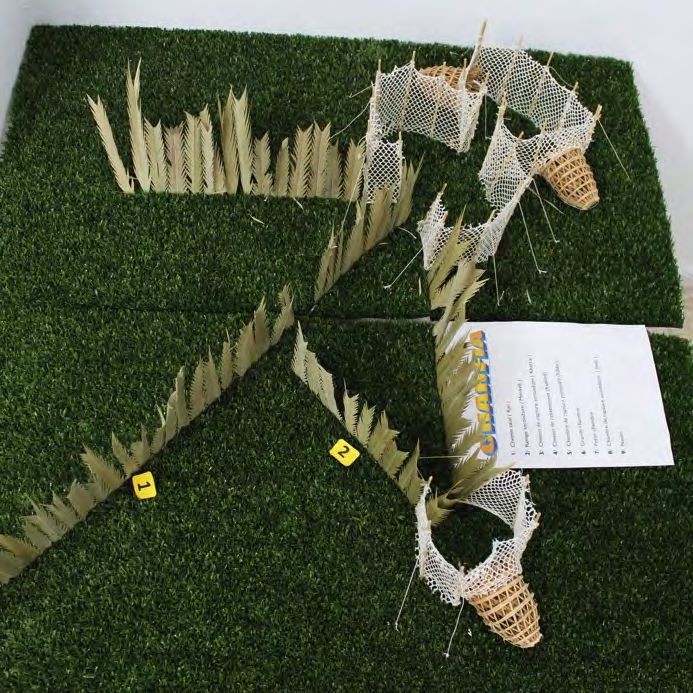
Integration of climate variability and change into national
                     ICZM strategies

   Contribution to the updating of the integrated
 management plan for coastal zones of the Kerkennah
                    archipelago

                        Report

                    September 2015

  Bruno Chatenoux, Karin Allenbach (UNIGE/GRID-Geneva)
           Pascal Peduzzi (UNEP/GRID-Geneva)
    Antoine Lafitte (Plan Bleu/Regional Activity Center)
       Sarra Touzi, Meriam Ben Zakour (GWP-Med)

                             1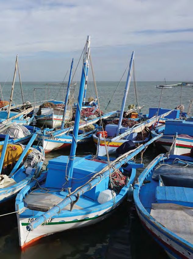
UNIGE / GRID-Geneva                         Plan Bleu                       GWP Med
UNEP / GRID-Geneva
                                            15, rue Beethoven               12, Kyrristou Str.
Global Change & Vulnerability Unit
                                            Sophia Antipolis                105 56 Athens, Greece
11, ch. des Anémones
                                            06560 Valbonne, France
1219 Châtelaine                                                             http://www.gwpmed.org
Geneva, Switzerland                         http://planbleu.org
http://www.grid.unep.ch

Authors
Bruno Chatenoux, Karin Allenbach (UNIGE/GRID-Geneva); Pascal Peduzzi (UNEP/GRID- Geneva) ; Antoine
Lafitte (RAC/Plan Bleu); Sarra Touzi et Meriam Ben Zakour (GWP-Med).

Citation
Chatenoux, B., Allenbach, K., Peduzzi, P., Lafitte, A., Touzi, S. & Ben Zakour, M. 2015. Integration of climate
change variability into national GIZC strategies: “Contribution to the updating of the integrated
management plan for coastal zones of the Kerkennah archipelago”. GRID-Geneva, Plan Bleu/RAC and GWP
Med.

Financing
This study is one of the activities of the ClimVar project (complementary regional project of the
MedPartnership project involving 11 Mediterranean countries funded by GEF). The implementing agency is
the UNEP MAP, and executive partners, the UNEP / GRID-Geneva, GWP-Med and RAC/Plan Bleu.

Acknowledgments
This report would not exist without the help of Mr. Chihaoui Mahmoud, General Manager of the APAL, Mr.
Adel Abdouli, Director of the Coastal Observatory and Focal Point of the Project, Ms Kaouther Houidi, Morsi
Feki, and Mr. Mohammed Bejaoui from the APAL for logistical support.
The information and collaboration of Ms. Lucille Etienne from the University of Paris 7 were also an
invaluable source of information.

Limit of responsibility
The opinions expressed do not necessarily represent the decisions or policies of the United Nations. In
addition, the designations employed in this publication and the presentation of included material do not
imply on the part of the UNEP any opinion whatsoever concerning the legal status of any country, territory,
city or area or of its authorities, or concerning the delimitation of its frontiers or boundaries.
This publication may be reproduced, in whole or in part, in whatever form, for educational or nonprofit
purposes without the prior permission of the copyright holder, provided that mention is made of the
source. Nevertheless, the UNEP would like to be informed of any copy of the publication where the
relevant extract is reproduced.
This publication may not be used for resale or other commercial purposes without prior written consent of
the UNEP.

                                                      2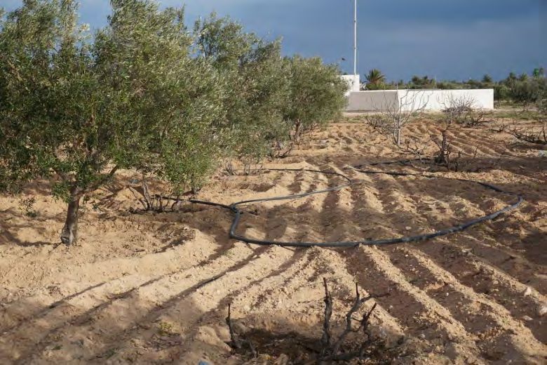
Table of Contents
Acronyms and abbreviations ......................................................................................................................... 5
1. Introduction .................................................................................................................................................. 6
   1.1 Reducing locally induced environmental threats for a climate change adaptation .................... 6
   1.2 Project demonstration in Tunisia ....................................................................................................... 6
   1.3 Kerkennah as a study area ................................................................................................................. 7
   1.4 Applied methodology ........................................................................................................................... 8
   1.5 Reports and products ........................................................................................................................ 10
   1.6 Partners involved................................................................................................................................ 10
2. Context ....................................................................................................................................................... 10
   2.1 Regional (the gulf of Gabes) ............................................................................................................ 10
   2.2 Local (Kerkennah Archipelago)........................................................................................................ 11
     2.1.1 Climate.......................................................................................................................................... 12
       2.2.2 Population .................................................................................................................................... 12
       2.2.3 Water resources .......................................................................................................................... 14
       2.2.4 Waste Management ................................................................................................................... 14
       2.2.5 Fishing .......................................................................................................................................... 15
       The ‘Gacharas’ (speculators) .............................................................................................................. 17
       2.2.6 Agriculture .................................................................................................................................... 17
       2.2.7 Tourism ......................................................................................................................................... 18
       2.2.8 Petroleum Activities .................................................................................................................... 18
       2.2.9 Bathymetry ................................................................................................................................... 19
       2.2.10 Biodiversity ................................................................................................................................ 19
       2.2.11 Governance ............................................................................................................................... 19
3. Local vulnerability to natural hazards .................................................................................................... 20
4. Coastal erosion and vulnerability of means of subsistence ........................................................... 21
   4.1    Coastal Erosion ............................................................................................................................. 21
   4.2    Tourism........................................................................................................................................... 23
   4.3    Agriculture and the risks of soil salinization .............................................................................. 24
   4.4    Fishery resources ......................................................................................................................... 25
5. Use of ecosystems to protect the territory ............................................................................................ 25
6. Ecosystems and priority threats identified during consultation workshops ..................................... 26
7. Threats Analysis Services Solutions for priority ecosystems ............................................................ 29
   7.1 Vegetation submarine........................................................................................................................ 29
     7.1.1 Services ........................................................................................................................................ 30
       7.1.2 Threats.......................................................................................................................................... 30
       7.1.3 Solutions....................................................................................................................................... 31
   7.2 Sebkhas ............................................................................................................................................... 31
     7.2.1 Services ........................................................................................................................................ 32
       7.2.2 Threats.......................................................................................................................................... 32
       7.2.3 Solutions....................................................................................................................................... 32
8. Centralization and sharing of data ......................................................................................................... 32
   8.1 Digital cartography of urban cores of Kerkennah .......................................................................... 33
   8.2 Data collected as part of KfW activities .......................................................................................... 33
                                                            3
8.3 1939 Aerial images ............................................................................................................................ 33
   8.4 Collection of recent high-resolution satellite images .................................................................... 33
   8.5 Detection hedging changes of underwater vegetation ................................................................. 34
   8.6 Distribution of the population ............................................................................................................ 35
   8.7 Location of chrafi traps ...................................................................................................................... 36
   8.8 Digital Elevation Models (DEM) ....................................................................................................... 37
9. Recommendations and conclusions...................................................................................................... 37
   9.1 General recommendations ............................................................................................................... 38
References..................................................................................................................................................... 40
Internet links .................................................................................................................................................. 42
List of Contributors........................................................................................................................................ 43
   Participants of workshop I ....................................................................................................................... 45
   Participants of workshop II ...................................................................................................................... 49
Annex .............................................................................................................................................................. 52
   Quantification of coastal erosion by Etienne (2014) ............................................................................ 52
Data provided by the partners .................................................................................................................... 52
   APAL (via the focal point Mr. Adel Abdouli) .......................................................................................... 52
   UNEP/GRID-Geneva................................................................................................................................ 54
     Aerial Imaging 1939.............................................................................................................................. 54
       Title: Aerial Imaging 1939 .................................................................................................................... 54
       Buildings 2012-2014............................................................................................................................. 55
       Percentage of buildings 2012-2014 ................................................................................................... 56
       Subaquatic vegetation in 1939 ........................................................................................................... 57
       Collection points of cherfia 1939 ........................................................................................................ 59
   Access to the data centralized by the project ....................................................................................... 61

                                                                                  4
Acronyms and abbreviations

MPA      Marine Protected Area
APAL     The Agency of Protection and Coastal Management
APIP     Agency of Ports and Fisheries Facilities
DPM      Maritime Public Domain
GDA      Grouping of Agricultural Development
INS      National Statistics Institute (Tunisia)
DTM      Digital Terrain Model
UNEP     United Nations Environment Programme
RiVAMP   Risk and Vulnerability Assessment Methodology Development Project
GIS      Geographic Information System

                                                   5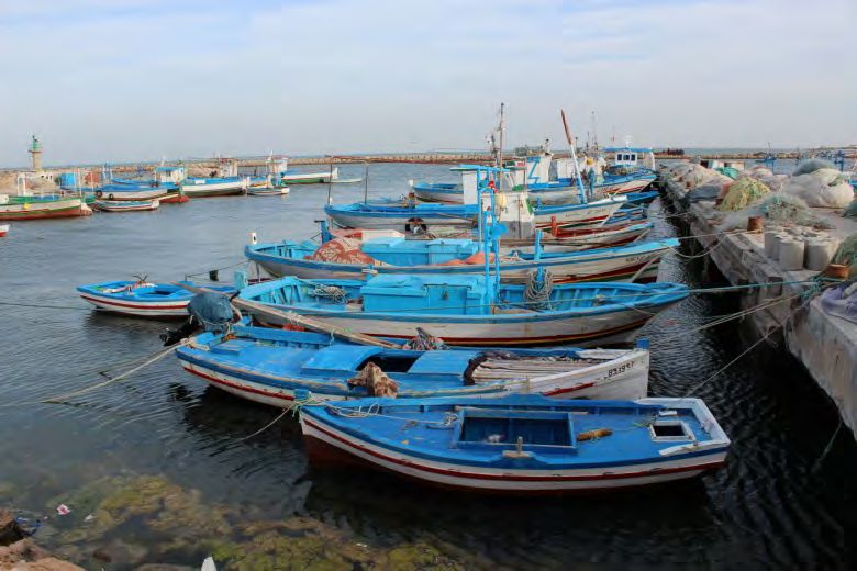
1. Introduction
1.1 Reducing locally induced environmental threats for a climate change
adaptation
The populations of small islands, especially those in developing countries, have no possibility to influence
the reduction of CO2 emissions in a significant way. These populations suffer the impacts of global change
even though they have marginally contributed to. Their only possibility for adaptation (to climate change)
consists of reducing locally induced impacts through better management and conservation of natural
resources.
This study is based on two approaches. On one hand, the data analysis and field validation in order to
identify the status of the environment and, on the other, a consultation of national experts, civil society and
other local stakeholders to understand the processes that led to this situation and to identify threats
weighing on the ecosystems and the potential solutions for their preservation.
In addition, the ecosystems provide multiple services such as carbon storage, coastal protection against
erosion, water filtration, and contribute to the quality of the landscape and recreational areas.
In order to identify and quantify the role of the quality of ecosystems in climate change adaptation, the
project approach is based on a collection of the finest data possible. These allow seeing the evolution of
certain phenomena, but also the realization of a cadastre of ecosystems allowing better consideration of
the latter in planning and in regional developments as well as their monitoring.
This concept is based on a methodology called "Risk and Vulnerability Assessment Methodology
Development Project (RiVAMP)" that allows decision makers to take informed decisions supporting
sustainable development through a better ecosystem management. In this regard, the targeted end users
of RiVAMP are the national and local government policy makers, and key stakeholders in the management
of natural resources and disaster management.
The concept of RiVAMP was developed by UNEP GRID-Geneva and tested successfully in a context of
eroding beaches in Negril region of Jamaica (UNEP, PIOJ 2010; Peduzzi et al 2013.). The purpose of this
study is to try to adapt this process to the context of the Kerkennah archipelago by combining it with the
Climagine participatory approach that ensures a structured involvement of all stakeholders.
1.2 Project demonstration in Tunisia
The Gulf of Gabes by its geographical, morphological, biological and climatic characteristics is mentioned in
the scientific literature as a "scale model of the Mediterranean" and a living laboratory for climate change
impacts in the Mediterranean. It also contains the biocenosis Posidonia Oceanica most extensive in the
world.
It is in the Kerkennah archipelago, which is located in the Gulf of Gabes that we find tiger structure of
Posidonia Oceanica; a fragile and unique ecosystem to be preserved. In a context of climate change and
rising sea levels, taking account of the risks incurred by the archipelago is a leading emergency.
The role of ecosystems in reducing the risks generated by extreme events is one of the most undervalued
ecosystem services. However, it is the subject of increasing interest especially since the earthquake and
tsunami in South Asia in 2004, which gave rise to an international awareness of the importance of
ecosystem management to protect communities and infrastructure against disasters caused by extreme
events. Ecosystems can serve as natural buffers or protective barriers, including the reduction of floods,
slope stabilization and coastal protection against storms. Furthermore, they increase the adaptive capacity
of communities to these events by serving them as means of subsistence. For example, Posidonia meadows
can reduce the impact of storm surges by dissipating wave energy; protect the beaches from erosion due to
the accumulation of plant debris (benches) on the shore, quickly decreasing water turbidity through the
rapid sedimentation of suspended particles, while providing natural habitats for the reconstitution of fish
stocks.

                                                      6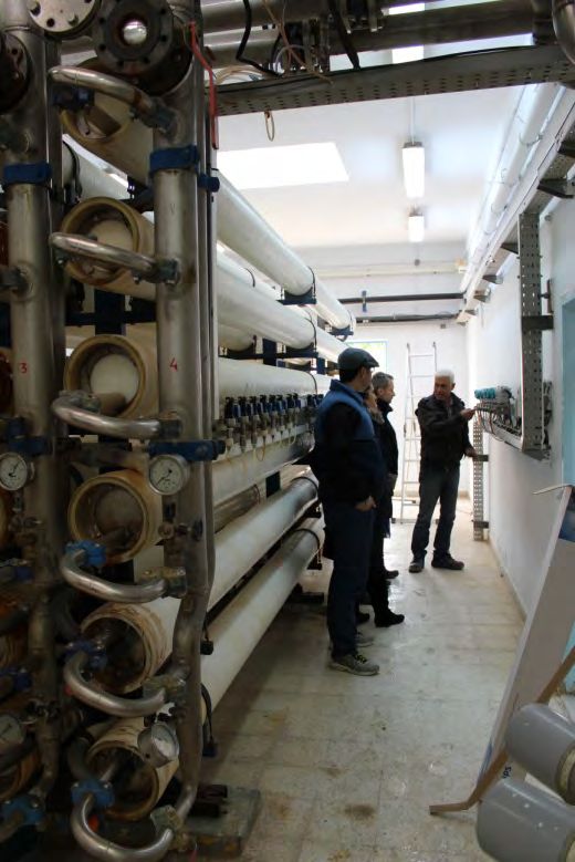
On the Kerkennah archipelago, the fisheries resource is one of the ecosystem services that matter most to
the local economy. It is, however, the one that is the subject of a greater threat due to illegal and
unsustainable fishing practices. Posidonia herbarium is the predominant marine ecosystem, its ecological
role is considerable (oxygenation, stabilization funds, production of organic matter, source of food, shelter
and spawning ground for many organisms). Terrestrial vegetation also plays an important role for the
reduction of erosion and against soil salinization.
One of the major concerns in the context of climate change is increasing the frequency and intensity of
extreme hydrometeorological events that will result in a corresponding increase in the number or
magnitude of catastrophic events. Over the last two decades (1988-2007), 76% of global disasters were
hydrometeorological, representing 45% of all deaths and 79% of total economic losses from natural
disasters.
Furthermore, climate change will affect the underlying factors of vulnerability, such as food security,
ecosystem services and migration phenomena, and therefore increase the risk. With the rise of sea level,
climate change will intensify the impact of storm surges, increase coastal erosion, as well as the salinization
of soil and groundwater; phenomena already observed on the archipelago of Kerkennah.
Three components have helped contribute to the results presented in this report.
    1. The collection and centralization of data on the Kerkennah archipelago, and the collection and
       extraction of information from existing studies and reports.
    2. The consultation of national experts, local, civil society and other local stakeholders (policy makers,
       representatives of fishermen...).
    3. A field campaign for the observation of impacts.
The combination of these three approaches has helped highlight the importance and the role of some
ecosystems, threats facing them, and the identification of possible solutions for their preservation and
restoration. These observations allow giving recommendations for the implementation of actions to reduce
local threats, and thus, enhance the potential for adaptation to climate change. The gathering of data and
reports will allow their access facilitated by all sorts of actors and will participate in capacity building for the
implementation of public policies and spatial planning, protective of ecosystems.

1.3 Kerkennah as a study area
The Kerkennah archipelago, located in the Gulf of Gabes, was selected for its vulnerability to variations and
climate change, its ecological richness has got a significant number of data including environmental one.
The Kerkennah archipelago consists of two main islands, the island Chargui (or greater Kerkennah) and
Gharbi island (or Mellita), and a set of twelve islands. The coastal areas of the islands consist of "shores"
rather than beaches that are characterized by very limited spaces.
The physical marine environment of the archipelago is very dynamic and multifaceted. It is characterized by
the importance of the tidal phenomenon which can be a major handicap in setting the shore and setting
isobaths around the archipelago. The archipelago has many underwater channels that give it a specific
topographic landscape. These channels have a considerable effect on marine dynamics and are among the
explanatory mechanisms of the development of the coast.
The presence of some ecosystems like coral or seagrass Posidonia releases material that can be either
pushed off seaward, or pushed toward the shore causing a sedimentary abundance at this level1.

1
 This phenomenon is observed in the Jamaican case investigated by UNEP GRID-Geneva, where the debris produced
by the destruction of corals are driven towards the lower area of the underwater beach by gravity and accumulate
there.

                                                         7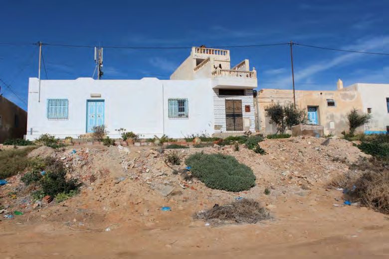
The hydrodynamics at the Kerkennah archipelago is not favourable to the shores reconstruction
phenomenon that can assist in remedying the anthropogenic erosion.
Some areas of the archipelago, El Attaya and El Krakna, often record flooding which would be due to the
elevation of groundwater level and lack of infrastructure for the disposal of rainwater.
The population of the archipelago is estimated at about 15 000 inhabitants in winter and up to 200 000
people during the summer season especially with the return of the natives of the Kerkennah archipelago
for the holidays and the arrival of tourists. This seasonal population pressure is a major challenge for
planning in the archipelago.
The main economic activity in the archipelago is fishing which is characterized by the use of ancient
techniques of trapping and capture. The chrafis coastal fisheries are fixed in the shape of a maze and used
in areas with high sediments and large tidal range. These old traditional techniques once respectable of the
environment see today their biodegradable building materials increasingly replaced by synthetic products.
Another characteristic fishing technique of the archipelago is fishing with gargoulettes for catching octopus.
Today, this technique is used intensively.
There is no agricultural tradition rooted in the archipelago. However, certain characteristic crops are
threatened because of anthropic pressure and the abandonment of the activity; like the date palm which is
a genetic heritage of great importance.
The Kerkennah archipelago has numerous archaeological sites that testify to the important role played by
this region throughout history. This cultural heritage is also threatened by the erosion phenomenon
coupled with anthropogenic activities.
The archipelago also knows a major waste management problem. Indeed, much of solid waste ends up in
the archipelago sebkhas (low and salty Arid Zones), vacant land or waters of the Mediterranean.
The wastewater is collected in the island only at a rate of 20%. In addition, the treated water is discharged
too close to the shore.
Oil and gas extraction concessions near the coasts of the archipelago have also been granted in recent
years.

1.4 Applied methodology
The regional project entitled "Integration of climate variability and change (CVC) into national strategies for
integrated coastal zone management (ICZM)" (ClimVar) is a complementary project of the MedPartnership
project. One of the project activities focuses on the assessment of environmental and socio-economic costs
of climate variability and climate change in coastal areas in an effort to contribute to the development or
updating of integrated coastal zone management plans.
The analysis is based on the RiVAMP model that bases its results simultaneously on scientific models and
qualitative consultations in order to demonstrate the role of ecosystems in reducing disaster risk and
reduction of impacts related to climate change. However, in the ClimVar project, consultations are based
on the participatory approach Climagine to provide a structured stakeholder involvement in planning
for the future of the coastal area in the archipelago of Kerkennah.
The Climagine method stems from the Imagine method, a participatory method based on sustainable
development indicators, the scenario method and the shared expertise of local actors. The Blue Plan uses
this method (in partnership with PAP/RAC) since the 2000s in various projects for ICZM in Algeria, Lebanon,
France, Slovenia and Spain. Each time its implementation is different because it must adapt to the local
context, but it has met great interest in all the projects, in order to become the backbone of integrated
coastal management.
The involvement of stakeholders is a prerequisite for the success of ICZM. In the case of our study in
Kerkennah, we are interested, as described previously, in quantifying the role played by ecosystems in

                                                      8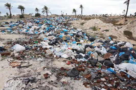
reducing disaster risk and the reduction of impacts related to climate change. Given that this is an area with
a certain degree of scientific uncertainty, the role of local actors, as experts at their level, in the process of
proposals of strategic actions to adapt to climate change impacts is even more important.
Climagine was structured around three participatory workshops. The first, a national consultation was
held in June 19, 2014 in Tunis, the second local consultation, held in Kerkennah in January 2015, while the
third was the subject of a double restitution in July 2015 in Tunis (National restoration) and Kerkennah
(local restitution).
The purpose of the work envisaged in the context of this participation activity is (i) to identify vulnerable
coastal sites with environmental and socio-economic change and climate variability of the archipelago, (ii)
to propose measures to mitigate and adapt to the consequences of the expected changes and (iii) to
formulate strategic guidelines to be included in the update of the management plan. This participation
activity was based on the work of collective expertise and results of Tunisian coastal vulnerability study
facing rising sea levels due to climate change conducted by the Agency of Protection and Coastal
Management (APAL), the adaptations to climate change impacts would significantly reduce economic,
social and potential environmental damage. The proposed adaptation measures should be incorporated
into a strategic plans and documents of development and management that are appropriate both locally
and nationally.
As this is a pioneering experience in Tunisia in terms of integration of climate considerations in coastal
planning, we expect that this significant experience serve to national coastal zone management, and that it
will be useful for other coastal areas. We also expect that some of the proposed measures are taken into
account by both national and regional bodies for the management of coastal areas.
In this perspective, the first consultation workshop aimed at:
• Building a common understanding of eco-socio-system of the Kerkennah archipelago and make an
inventory of APAL data already acquired and also seek other useful data providers for the study.
• Identify the predominant factors of coastal erosion and associated risks for the socio-economic
development of the archipelago.
• Identify potentially useful and available data.
The overall objective of the second consultation workshop was, after a phase of analytical work with the
leaders of APAL, to go in situ and mobilize the expertise and local knowledge to further refine the
assessment of ecosystem roles and to better understand local organizational dynamics.
The second workshop Climagine main objectives:
• Identification of the main livelihoods and ecosystems of the archipelago;
• The highlighting of the degradation processes in the archipelago;
• conducting a "Threat-Service-Solution" analysis to highlight:
    o   the roles played by the different ecosystems and the services they offer to reduce vulnerability to
        variability and climate change,
    o   the identification of threats facing ecosystems
    o   and potential solutions to these threats;
• reviewing the pre-selection of potential areas of study.
The third workshop was an opportunity to present the results of work as well as strategic
recommendations for the revision of the integrated management plan for coastal areas of Kerkennah.

                                                        9
oct-13 Nov-13 to May-14 June-14 Jul-14 to Dec-14 janv-14 Feb-15 to June-15 juil-15
Launching meeting in Tunis
Analysis of available data / Contact with APAL
and with possible data providers / Literature
reviews
1st consultation workshop (National)
Elaboration of GIS Maps (Habitat density,
seagrass, Fishery sites ...) and remote sensing
analysis
Second consultation workshop (Local)
Finalization of products :
Drawing maps / Creating the platform / Writing
deliverables
Third consultation workshop (Presentation of
results (national and local levels)
Figure 1 Calendar of project activities
1.5 Reports and products
In addition to this document, a summary document and the reports of participatory consultation
workshops and a geographic database (GIS QGIS project) have been created and are available for download
at http://kerkennah.grid.unep.ch/ associated with a set of documents related to the issues addressed in
this project.
1.6 Partners involved
The study was implemented through collaboration between the following partners:
• APAL: Mr. Chihaoui Mahmoud, Mr. Adel Abdouli, Ms. Ben Khaouter Houidi, Mr. Morsi Feki;
• GRID-Geneva: Mr. Bruno Chatenoux, Ms Karin Allenbach, Mr. Pascal Peduzzi & Mr. Jean-Philippe Richard;
• Global Water Partnership Mediterranean (GWP-Med): Ms. Sarra Touzi, Ms. Meriam Ben Zakour;
• Plan Bleu/RAC: Mr. Antoine Lafitte.
Several other partners have been consulted and have contributed to the development of the study through
the provision of expertise and the provision of information. The full list of partners consulted is given in
Appendix.
2. Context
2.1 Regional (the gulf of Gabes)
The Gulf of Gabes has regional specificity (in the Mediterranean context) by its geomorphology and its
ecosystem ranking it among the most significant primary production seas (Barale, 1994), with great socio-
economic importance since ancient times, making it a model of the Mediterranean Sea.
The unique configuration of the Gulf of Gabes has enabled the establishment of a remarkable natural
seacoast system such as the development of the most extensive biocenosis Posidonia Oceanica in the world
(which extends to the Gulf of Sirte in Libya) (Ben Mustapha and Alfi, 2007). These vast areas of seagrass
beds favour the reproduction and development of many marine species.
However the expansion of seagrass Posidonia is declining, as are Cymodocea meadows that have even
disappeared in some areas. Only seagrass Posidonia located off the archipelago of Kerkennah that does not
exhibit a regressive trend. However, their striped structure makes them very vulnerable to any aggression
by the reduced width (1 to 2 m) structural elements (Hamza et al., 2000). Because of their scarcity and
incurred pressures, tiger structure is large heritage buildings requiring urgent and efficient conservation
policy (Pergent et al., 2010)
10The concomitance of the following physical and hydrological characteristics; very shallow depth, large
amplitude waves and the presence of channels and throttle has characterized this area as the place where
we find the most important currents of the Mediterranean (Abdouli A. Internal communication).
Unlike most of the Mediterranean coasts where the tide is imperceptible, the amplitude of the tide is high
and maximal south of the Gulf of Gabes (2 m during spring tides) (Serbaji, 2000) with current speeds up to 2
m / s in the pass of El Kantara.
Tidal currents generally vary based on current swells and winds. The currents generated by winds that can
be 2 to 5 times stronger than the tidal currents. They play a major role in the transport and dispersion of
pollutants and sediments along the coastline (Drira, 2009). The complex interactions between the tide,
wind and water mass movements create ocean currents and therefore unpredictable and highly variable
sedimentary dynamics.
Fishery resources are very important in the Gulf of Gabes due to favourable climatic, geomorphological,
oceanic and environmental conditions. However this region also concentrates various socio-economic
activities (urbanization, agriculture, industries, oil exploration, fishing ...) that have negative impacts on
ecosystems and therefore on natural resources that depend on it. Drira (2009) mentions an increase in the
frequency of eutrophication phenomena, and the degradation and loss of large areas of vegetation cover
over the last decades.
Two thirds of Tunisia's fish production comes from the Gulf of Gabes (CGP, 1996) that concentrates
approximately 75% of trawlers, two-thirds of the national fleet and 62% of the Tunisian maritime
population (Missaoui et al., 2000). 29% of fishery products of the governorate of Sfax come from the
coastal waters of the Kerkennah archipelago (Munir, 2004).
2.2 Local (Kerkennah Archipelago)
The Kerkennah archipelago is located 20km offshore from Sfax in the Gulf of Gabes, it is composed of two
main islands Gharbi and Chergui and twelve islets: Charmandia, Sefnou, Roummadia, Gremdi, Lazdad, Er
Rakadia plus the six islets of Haj Hmida. It is prolonged according to a Southwest Northeast direction
measuring about 35km long and 11km wide and an area of 160 km² and includes 162km of coastline.
Figure 2 General map of the Kerkennah archipelago
Source http://kerkennah.grid.unep.ch/maps/59/view
11The Kerkennah archipelago is the tip part of a vast underwater plateau that extends from 9-50 km around
the islands. Its average depth is 2m, and varies between 0 and 5m, the plateau is interspersed with
channels that can reach 20m and pits up to 30m (Amari, 1984).
2.1.1 Climate
Although there is no official permanent meteorological station on the Kerkennah archipelago, the
comparison of point data coming from various studies (APAL, 2001; Fehri, 2011) with official data from the
weather station of Sfax concludes that the archipelago receives the same amount of rainfall but with
slightly different temperatures. The presence of moisture in the sea around the archipelago increases
humidity and decreases the temperature difference between the land and the sea (Etienne, 2014).
The amount of annual precipitation greatly varies from one year to another, and generally varies between
100 and 400mm (Dahech, 2007).
F M A M J J A S O N D Total
J
P (mm) 14 27 17 4,9 0,9 0,5 1,1 21,5 44 33,7 35,7 223,6
23,7
ETP (mm) 37,4 49,6 77,5 107,7 152,2 184,4 199,6 170,2 116,2 80,3 48,5 36,4 1260,0
ETP-P 13,7 35,6 50,5 90,7 147,7 183,5 199,1 169,1 94,7 36,3 14,8 0,7 1036,4
(mm)
P/ETP 0,63 0,28 0,35 0,16 0,03 0,00 0,00 0,01 0,19 0,55 0,69 0,98 0,18
Table 1 Elements of water balance in the Kerkennah islands in the period 1965-2009 (from Fehri, 2011)
The calculation of the water balance in Table 1 shows the water deficit in which the Kerkennah archipelago
is subject, resulting in soil salinization caused by the capillary rise of the water table (usually composed of
brackish water).
A weather station was commissioned in late 2014 on the roof of the residence Ennakhla (Dahech, personal
communication, February 2015).
2.2.2 Population
Year Population
1890 8'671
1925 13'000
1936 15'130
Census population
1946 14'535
1956 13'704
1966 12'587
1975 14'500
1984 14'151
1994 14'062
2004 14'400
2014 15'501
Figure 3 Population of the Kerkennah archipelago recorded by the INS (Louis 1961, Etienne 2014, INS 2014)
The number of residents identified on the archipelago remains stable for several decades (Figure 3) with a
resident population estimated by the Tunisian National Institute of Statistic (INS) to 15'501 (100% urban) in
122014, an increase (since 2004) of 7.7% of the population (10.8% national value) in a context of diminishing
size of households (-1.6%) and increase in housing (3.6%) (Table2).
Sector Men Women Total Household Housing
El Ataya 1'548 1'529 3'077 828 1'282
El Ramla 1'067 1'019 2'086 655 1'132
Sidi Frej 313 256 569 207 610
Melita 1'849 1'707 3'556 862 1'265
El Kalabine 393 370 763 226 567
En-Najet 480 762 1'242 276 440
El Chargui 183 170 353 121 548
El Kantra 434 226 660 168 549
El Kraten 568 585 1'153 300 429
Ouled Kacem 492 449 941 290 675
Total 2004 7'327 7'073 14'400 3'933 7'497
Total 2014 7'733 7'768 15'501 3'869 7'770
Table 4 Census 2004 and 2014 (INS)
The Kerkennah archipelago faces an aging population demonstrated by this inverted pyramid of ages
(Figure 4).
Figure 4 : Age pyramid 2014 for the Kerkennah archipelago (INS)
While the number of residents remains well known and relatively stable, the visitors’ number (mainly
during the tourist season) is subject to speculation. Rhouma et al. (2005) estimate the number of visitors to
be between 40,000 and 50,000 per year. Moreover, the figure of 240,000 visitors was mentioned during
the meeting of experts in Tunis in June 2014. However, this value appears to represent the number of
passenger boats connecting the islands to the mainland, but the nature and the length of stay are
unknown. In order to get a better idea of the pressure generated by the population of visitors, it would be
appropriate to calculate the amount of nights in a hotel and the occupancy rate of second homes.
Although the rate of increase of housing is lower than that of the population (Table 2), the intensive
construction of new buildings is clearly visible (field mission UNEP/GRID-Geneva, January 2015), which
further amplifies human pressure on local resources for construction materials, such as sand or rocks. As
the import of building materials from the mainland triple their costs, a significant amount of sand and rock
unlawfully levied on the spot or by drawing on the meager resources of the islands beaches, or digging
illegal quarries. The illegal extraction of building materials has consequences for the reduction of tourist
13attractiveness, the acceleration of coastal erosion rate and the acceleration of soil salinization of surface
and groundwater.
In her thesis work, Etienne (2014) mapped the evolution of surfaces built between 1963 (119 ha), 1984
(168 ha) and 2010 (719 ha), indicating that the expansion of built areas has mainly taken place since 1984.
Kebaïli Tarchouna (2013) indicates that since the Tunisian revolution in 2011, the construction of buildings
without building permits which do not respect the law of development of the territory has become more
frequent. Notably, near the coast (requiring the work of setting up coastal defenses) or around sebkhas.
2.2.3 Water resources
The Kerkennah archipelago is located on two aquifers. The first is shallow flush in low natural or artificial
areas (quarries of sand or rocks); it is brackish and only used for irrigation, thus contributing to soil
salinization when excess water is not drained by a drainage system. The second is deep (350 m) and it is
part of the confined aquifer of the Sahel; it is used for fresh water supply of the population.
A reverse osmosis desalination plant (the first in Tunisia) is in
operation since 1983 in Kerkennah and produces 3,300 m3/day.
However, when high demand (during the tourist season), saline
water is added to the fresh water to produce up to 6000 m3 of
water, but in this case the salt concentration reaches 1.5g per liter
(maximum level permitted by international standards). Due to the
low quality and quantity of water in the distribution network and a
low connection rates, the vast majority of the archipelago's
buildings have a recovery tank of rainwater.
Discards of water loaded with salt - 25% of the quantity of water
produced with a salt content of 14 g/L (Malek, 2007) - is now
carried out directly on the shore.
Figure 5 Water treatment plant using
reverse osmosis (photo UNEP/GRID-
Geneva, 2015)
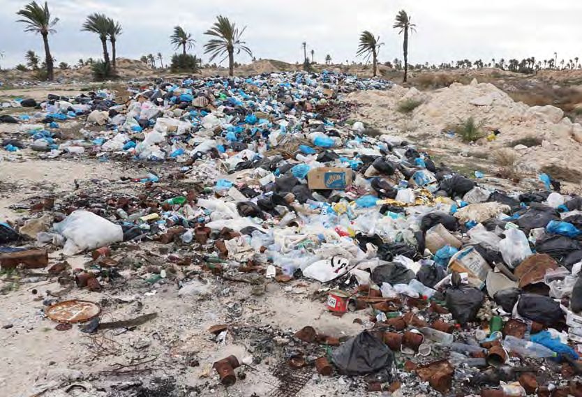
2.2.4 Waste Management
There is a waste treatment plant in Kerkennah. However, due to disagreements about issues of land
ownership, it was closed by court order pending resolution of the legal dispute.
14In the meantime, the waste is centralized at the
exit of the villages (usually within sebkhas) or
simply dumped outside properties.
These open dumps are a source of pollution for
coastal waters and shallow groundwater and
degradation of the landscape by the dispersion
of waste by the wind in the archipelago.
Figure 6 Wild waste disposal (photo UNEP/GRID-Geneva, 2015)
The management of waste construction is also
problematic, insofar as they are commonly
used as embankments or protection against
coastal erosion. These protection structures are
easily eroded. This, therefore results in a quick
remobilization of sediments by ocean currents
and their scattering along the coast.
Figure 7 backfill made with waste (photo UNEP/GRID-Geneva,
2015)
2.2.5 Fishing
Maritime activities are dominant in the
archipelago of Kerkennah. It is that they revolve
around the economic activities and the social
and institutional relations. Appropriate
traditional fishing techniques (transmitted from
generation to generation), scheduled in time
and space, are managed by an accepted social
rules and respected by the community (and
Rhouma Labidi, 2006).
Figure 8 The archipelago boasts impressive fleet of fishing
boats (photo UNEP/GRID-Geneva, 2015)
The coastal waters of the Kerkennah archipelago are the main concentration area of chrafis (traditional
artisanal fishing) that capture the coastal species, sometimes immature or protected shallow depths
15(Romdhane and Missaoui, 2002). Traditionally chrafis were built mainly with products of date palm,
installed and operated in the autumn (September-October) in early summer (June-July) and then
dismantled for a period of biological recovery. Nowadays fishing nets, PVC pipes and ferrous materials have
replaced the products from the date palm, and are left in place for several years; they no longer respect the
biological rest.
The "loud", a sailing vessel with a low draft characteristic of the archipelago, has been replaced by motor
boats since the 1970s, which were encouraged by the granting of loans to fishermen (Rhouma and Labidi,
2006).
Traditionally, the Kerkennah archipelago also has a strong octopus fishing activity called fishing jug
("Karour") or hollow stones and sponge fishing, although the latter activity has fallen sharply over the past
decade (COMETE Engineering , 2001).
The analysis of fisheries statistics in the waters of the Kerkennah archipelago remains complex and
uncertain for the following reasons: some fishermen of the archipelago prefer to sell their produce on the
mainland, also an important part of the catch is auto consumed. The catches are landing without control
outside the "official" ports and finally the continent fishermen operating in the coastal waters of
Kerkennah. APAL (2001) estimated that 60% of fisheries production is not surveyed (30% according to
Rhouma and Labidi, 2006).
Although official figures are subject to wide fluctuations, the unanimous opinion of those interviewed, as
well as all publications relating to fisheries, show a consistent decline in fisheries resources of the
Kerkennah archipelago, particularly octopus (which remains the emblem of the archipelago).
Figure 9 extracted from Rhouma and
Labidi (2006) used to display the
opposite trend between production and
the importance of the fishing fleet
Number of coastal boats
(minimum production in 1995, while the
Production (Tons)
fleet was at its maximum).
Figure 9 Evolution of the fleet and fishing production in the
Kerkennah archipelago (BCM: Motorized Boat Coast, BCNM: Seaside
Boat Non Motorized, source: APD extract of Rhouma and Labidi,
2006)
Figure 10 clearly shows the negative
relationship between production and
Number of motorized coastal boats
coastal fleet motorized boats (BCM), this
negative trend having the double of the
tendency with non-motorized coastal
boats. Although these figures are not
recent, they are the only ones available.
Production (Tons)
Figure 10 Correlation between production and the fleet of motorized
coastal fishing boats in the Kerkennah archipelago (from Rhouma and
Labidi, 2006)
16Although the available statistics do not take into account the fishing activities of the fleet based outside of
the archipelago and that their reliability is a matter of debate, they clearly demonstrate that any additional
effort (motorized or not) has a negative and immediate effect on the production in the waters of the
archipelago. Several causes can be invoked:
• The proliferation of motor boats - of which over 90% have no license (Rhouma and Labidi, 2006)
• The use of nets of all sizes leading to the capture of juveniles,
• Trawling activities are becoming more intense, including the 'kiss'2 in shallow areas,
• The illegal exploitation, unregulated and uncontrolled fishery resources,
• Non-compliance and lack of mutual tolerance between fishermen of different types of fishing.
The ‘Gacharas’ (speculators)
The degradation of fishing conditions is also related to the pressure exercised on fishermen by gacharas;
they are speculators who provide ‘kiss’ practitioners with the necessary funds for their businesses
(including costs and running expenses) against the exclusivity of their products. Rhouma and Labidi (2006)
we list the consequences as follow:
• Complex and devious marketing channels usually carried out without any control,
• Rapid and unregulated growth of the fleet,
• Submission of fishermen to the commercial conditions imposed by gacharas,
• Failure to comply with the regulations in force (no fishing season mainly for shrimp and octopus)
• The development of the Agricultural Development Group "GDA El Arkhabil" is hampered by debt and
submission of fishermen to the gacharas,
• Lack of mobilization of fishermen to defend their interests,
• Almost a complete rupture between the fishermen and their administrative and organizational
environment, the distribution network is mainly dominated by gacharas.
2.2.6 Agriculture
Agriculture and orchards were gradually
abandoned as a food crop. Rhouma et al.
(2005) estimate the area of fruit trees at 923
hectares in 2000, while Louis (1961) estimated
that at 6'190 hectares 4 decades ago. The
reasons are the growing phenomenon of
drought, the exodus of the workforce and the
high cost of plowing. However, a number of
short-term olive producers replanting projects
have been put in place to reverse that trend.
Figure 11 Irrigated agriculture (photo UNEP/GRID-Geneva,
2015)
2
Mini benthic trawl
17Etienne (2014) mapped the agricultural plots (Figure 12) and estimates the irrigated surface area of 178 ha
in 1984 and 662 ha in 2011, an increase of 272% related to artesian wells construction in the 1990s. These
constructions make available to farmers brackish water requiring the construction of drainage
infrastructure to minimize the phenomenon of soil salinization.
Figure 12 Mapping of agricultural activities in the Kerkennah archipelago
(Extract from Etienne, 2014, Figure 44, p. 96)
The irrigated areas were perpetrated in the spaces located "at altitude" (maximum 13 m) which limits soil
salinization phenomena by raising the level of the water table. However, locally gypsum soils are then
dissolved and can equally participate in a significant way in this phenomenon.
Opinions differ regarding the irrigated areas and the creation of new perimeters. Indeed, some inhabitants
partly associate them to salinization and advancing Sebkhas.
2.2.7 Tourism
Despite the existence of tourism infrastructure (six hotels with a capacity of 1,000 beds in the area of Sidi
Fredj), this activity barely grow with only 30% occupancy rate during a restricted period of operation. APAL
(2001) invokes the following reasons:
• Lack of real beaches and limited bathing potential,
• Difficult access to the archipelago (for boats and remote airports)
• Poor infrastructure,
• Lack of tourism strategy.
Despite these difficulties, two other tourism development projects are under consideration in the areas of
Founkhal and Ouled Ezzedine.
2.2.8 Petroleum Activities
Oil exploitation adds offshore pollution problems near tourist sites, often mentioned during the visit of the
GRID-Geneva team over the archipelago, and COMETE Engineering (2001).
18The risk of pollution of the coast of the archipelago by the oil operations at sea remains a reality all the
more worrying that the boreholes are located only a short distance from the coast and are directly exposed
to prevailing winds. In case of incident, pollution would be quickly transported to the shore, driven by the
characteristics of shallow marine and crossed by tidal channels. Moreover, this environmental disaster
would impact directly the only existing official tourist area of the archipelago, generating likewise an
economic catastrophe (COMETE Engineering, 2001).
2.2.9 Bathymetry
The reef flat of the Kerkennah archipelago is a large platform located at depths ranging from 0 to 5 m. The
morphology is divided into:
• "bhiras" mudflats of 2 to 3m deep (that can even exceed 5m), surrounded by Posidonia cords and
carpeted with Cymodocea,
• "tsirs" (or benches): barrier beaches, made up of biogenic debris shellfish whose top are populated by
meadows of Caulerpa sometimes emerging at low water
• "wadis" (or tidal channels): narrow winding depressions, of 5 to 12 meters deep by which circulate tidal
waters (it can reach a speed of 1.5 m / s).
Although the tidal channels are located in soft and loose sediments and therefore potentially mobile,
Etienne (2014) points out that the position of main channels has not changed compared to 1884
cartographic surveys.
2.2.10 Biodiversity
The seagrass Posidonia and Cymodocea once very widespread on the coasts of the Gulf of Gabes currently
no longer exist on the shallows of the archipelago of Kerkennah (Romdhane and Missaoui, 2002). However,
the high islands are home to the capital of the most remarkable Posidonia and Cymodocea seagrass beds in
the Mediterranean Sea with a unique morphology of tiger structure beds (Boudouresque et al. 2006).
These seagrass have great heritage value and constitute the major ecosystems of the Mediterranean. It is a
biodiversity center providing refuge to a quarter of species, Mediterranean (fauna and flora), and playing a
significant role in coastal protection against erosion.
The islands of the Kerkennah archipelago are also an important wintering grounds (Romdhane Missaoui
and 2002) for shoreline seabirds and other water birds; it is also an important crossing site for passerine
birds during migration. The islets located northeast of the archipelago exhibit remarkable biological
richness, with many rare or endangered endemic animal and plant species, (APAL, 2001). Moreover, part of
the island of Chergui is listed as a Ramsar site since November 2010.
2.2.11 Governance
Administratively, Kerkennah delegation is attached to the governorate of Sfax. Founded in 1964, it is
divided into ten imadas3 (El Ataya El Chargui, El Kallabine El Kantra, El Kraten El Ramla, Ennajet, Melita,
Ouled Kacem and Sidi Frej).
Kerkennah also counts a municipality that was created in January 1974. Following the revolution and like
many other communes across the country, a special delegation was introduced pending the municipal
elections. The means and resources of the municipality have become limited and constituted an issue as
crucial as the difficulties encountered by the municipality to assert its authority after the revolution.
Registered overruns are so numerous that they could be visually perceptible (building on the edge of the
coast, dumping of waste in sebkhas, etc.)
3
Imada is the smallest administrative division of Tunisia.
19The network of associations in the archipelago was animated in its majority by the will of the original
inhabitants of the islands in large cities (Tunis, Sfax, etc.) to contribute to the improvement of living
conditions in the archipelago. This has experienced a revitalization in recent years with the creation of new
associations and diversification of activities ranging from environmental awareness to improving scientific
knowledge without neglecting of course the actions of development and promotion of exploitation of local
heritage (cultural, culinary, etc.)
Concerning the socio-economic activities, the main source of income of the inhabitants comes from
seafood. One of the singularities of the archipelago is that fishermen own an offshore parcel which gives
them the right to enjoy marine resources but also to maintain these spaces. Property deeds have existed
since the 17th century.
Agricultural development groups (GDAs) are established at the level of irrigated areas and record variable
performance from one GDA to another.
The integrated management plan for the Kerkennah islands developed in 2008 called for the establishment
of an integrated management unit of the Islands (UGIK) bringing together all the stakeholders
(administrations of various sectors, local authorities, associations, socio-professional organizations
representing various interest groups) and equipped with sufficient human, regulatory and financing
resources to be able to implement the necessary management decisions. This unit has not been established
yet.
3. Local vulnerability to natural hazards
The estimate of the speed of current sea level rise in the Mediterranean basin remains uncertain. The
projections of the IPCC report in 2013 predict a global sea level rise of 26 cm and 82 cm (extreme values
according to the four modeled scenarios) by the end of the 21st century.
The estimate of the variation in sea level in the Gulf of Gabes in particular, gives varying trends depending
on the method of used analysis (tide gauge, satellite measure, or terrain indicators and modeling). Etienne
(2014) presents a good summary of the different used methods and their respective results. It concludes
that, although the rise in sea level in the Gulf of Gabes is probably minimal compared with the general rise
of the waters of the Mediterranean, the area will be affected by high relative sea level rise resulting from
generalized subsidence of the area.
Burollet (1979) estimated a three-meter submersion of the archipelago over the last 2400 years based on
the flooding of coastal archaeological sites. This subsidence is also confirmed by the writings of Pliny the
Elder, which indicate that the archipelago back then measured 37 km long and 18.5 km wide, while today it
measures no more than 30 km to 14 km. Slim et al. (2004) also identified the remains of ancient roads
between the island of Gremdi and the island of Chergui, confirming that at that time they were a single
land entity.
As part of the project, Climate Change and Impact Research: the Mediterranean Environment (CIRCE),
Harzallah et al. (2010) have made an estimate of future trends in the Gulf of Gabes:
• Increase in average daily temperature: ~ 0.5 ° C / decade
• Increase in daily maximum temperature: ~ 0.6 ° C / decade
• Increased frequency of very hot days: 0.7 days / month / decade
• Increased water temperature: ~ 0.12 ° C / decade
• Increase of the maximum height of wave: 1m / decade
• Sea level rise: ~ 2.6 cm / decade,
• Expansion of the tourist season: ~ 8 days / decade
• Decrease in days favorable to tourism: ~ 12 days / decade.
20You can also read