Interacting effects of land-use change and natural hazards on rice agriculture in the Mekong and Red River deltas in Vietnam - Natural Hazards and ...
←
→
Page content transcription
If your browser does not render page correctly, please read the page content below
Nat. Hazards Earth Syst. Sci., 21, 1473–1493, 2021
https://doi.org/10.5194/nhess-21-1473-2021
© Author(s) 2021. This work is distributed under
the Creative Commons Attribution 4.0 License.

Interacting effects of land-use change and natural hazards on rice
agriculture in the Mekong and Red River deltas in Vietnam
Kai Wan Yuen1 , Tang Thi Hanh2 , Vu Duong Quynh3 , Adam D. Switzer1 , Paul Teng4 , and Janice Ser Huay Lee1
1 Earth  Observatory of Singapore, Asian School of the Environment, Nanyang Technological University, Singapore, Singapore
2 Faculty  of Agronomy, Vietnam National University of Agriculture, Hanoi, Vietnam
3 Institute for Agricultural Environment, Hanoi, Vietnam
4 S. Rajaratnam School of International Studies, Nanyang Technological University, Singapore, Singapore

Correspondence: Kai Wan Yuen (yuenjq@gmail.com)

Received: 12 June 2020 – Discussion started: 13 July 2020
Revised: 20 February 2021 – Accepted: 28 March 2021 – Published: 12 May 2021

Abstract. Vietnam is a major rice producer, and much of the       ronmental challenges. Given that deltas worldwide are glob-
rice grown is concentrated in the Red River Delta (RRD) and       ally significant for food production and are highly stressed
the Mekong River Delta (MRD). While the two deltas are            and degraded, a systems-thinking approach can be applied to
highly productive regions, they are vulnerable to natural haz-    provide a holistic and contextualized overview of the threats
ards and the effects of human-induced environmental change.       faced in each location.
To show that the processes and issues affecting food secu-
rity are reinforcing, interdependent and operating at multiple
scales, we used a systems-thinking approach to represent the
major linkages between anthropogenic land-use and natural         1   Introduction
hazards and elaborate on how the drivers and environmental
processes interact and influence rice growing area, rice yield    A delta is defined as a low-lying sedimentary landform lo-
and rice quality in the two deltas. On a local scale, demand      cated at the mouths of rivers. The mixing of fresh water and
for aquaculture and alternative crops, urban expansion, dike      saltwater in these sediment-rich land–ocean coastal zones
development, sand mining and groundwater extraction de-           provides fertile land for agricultural activities to support a
crease rice production in the two deltas. Regionally, upstream    large number of people. Besides agriculture, resources in
dam construction impacts rice production in the two deltas        deltas have also been tapped for fisheries, navigation, trade,
despite being distally situated. Separately, the localized nat-   forestry, fossil energy production and manufacturing. Un-
ural hazards that have adversely affected rice production in-     fortunately, deltas are highly vulnerable to a range of envi-
clude droughts, floods and typhoons. Outbreaks of pests and       ronmental hazards such as typhoons, floods, storm surges,
diseases are also common. Climate-change-induced sea level        tsunamis, coastal erosion and seasonal inundations (Seto,
rise is a global phenomenon that will affect agricultural pro-    2011). In addition, local human activities, land subsidence,
ductivity. Notably, anthropogenic developments meant to im-       water stresses and global sea level rise have exacerbated their
prove agricultural productivity or increase economic growth       environmental vulnerability (Day et al., 2016; Syvitski and
can create many unwanted environmental consequences such          Saito, 2007; Tessler et al., 2015). The threats faced by deltas
as an increase in flooding, saltwater intrusion and land subsi-   are considered to be “wicked problems” with no easy solu-
dence, which in turn decreases rice production and quality. In    tions to counter them (DeFries and Nagendra, 2017).
addition, natural hazards may amplify the problems created           In this paper, we focus on the Red River Delta (RRD) and
by human activities. Our meta-analysis highlights the ways        the Mekong River Delta (MRD) in Vietnam as these two
in which a systems-thinking approach can yield more nu-           deltas are highly populated hubs of agricultural production
anced perspectives to tackle “wicked” and interrelated envi-      that are highly vulnerable to environmental hazards. We use
                                                                  a systems-thinking approach to illustrate some of the wicked

Published by Copernicus Publications on behalf of the European Geosciences Union.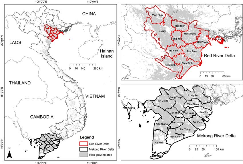
1474                     K. W. Yuen et al.: Interacting effects of land-use change and natural hazards on rice agriculture

problems present in the two deltas in Vietnam and the im-          in damage, of which USD 300 million was agriculture- and
plications of these anthropogenic and natural-hazard drivers       aquaculture-related damage (Nguyen, 2017).
on rice agriculture. Although a variety of crops are culti-           Arias et al. (2019) conceptually integrated local and re-
vated in Vietnam, we focus on rice as it is a staple food for      gional drivers of change to illustrate the factors contribut-
the Vietnamese (M. T. Nguyen et al., 2019; USDA, 2012),            ing to environmental change in the Mekong floodplains.
and it is also a key export crop. In 2019, Vietnam exported        Similarly, M. T. Nguyen et al. (2019) recognized that there
USD 1.4 billion of rice and was the fourth-largest rice ex-        are various drivers of change associated with adapting to
porter in the world, contributing 6.6 % of the world’s total       widespread salinity intrusion in the Mekong and Red River
rice exports (Workman, 2020).                                      deltas, and these drivers are constantly interacting with and
   Many studies have investigated how Vietnam is af-               providing feedback to each other. On a more technical level,
fected by natural hazards or anthropogenic land-use change         Chapman and Darby (2016) used system dynamics modeling
(cf. Howie, 2005; Minderhoud et al., 2018; K.-A. Nguyen et         to simulate the delays, feedbacks and tipping points between
al., 2019; Vinh et al., 2014). Several studies go a step further   farmers’ socioeconomic status and the practice of double- or
to examine how changes in anthropogenic land use have af-          triple-cropping in An Giang Province in the MRD. Building
fected rice productivity. For example, higher prices and rising    on the framework provided by these studies, we use systems-
demand for aquaculture and non-rice products have incen-           thinking to present an overarching picture of how anthro-
tivized farmers to shift away from rice monoculture to em-         pogenic and natural-hazard drivers can interact to reinforce
brace non-rice crops (Hai, 2021; Morton, 2020). In addition,       or diminish rice production. While many studies may have
environmental threats such as worsening saltwater intrusion        highlighted the links between the various drivers and rice
have limited rice production areas and forced many farmers         production, we seek to integrate the different drivers of an-
to convert their now-unusable rice fields into shrimp ponds        thropogenic change and natural hazards to show their inter-
(Kotera et al., 2005; Nguyen et al., 2017) or turn to growing      related and interdependent nature and how the processes as-
salt-tolerant crops such as coconut, mango and sugar cane          sociated with each driver affect rice growing areas, rice pro-
(Nguyen and Vo, 2017). Urban expansion is also another key         duction and rice quality in general.
factor that has reduced rice growing areas although agricul-          The use of systems-thinking is appropriate as the wicked
tural intensification has kept rice yields high despite shrink-    environmental problems present in the deltas of Vietnam
ing growing areas (Drebold, 2017; Morton, 2020).                   are caused by a range of interdependent anthropogenic and
   Meanwhile, the construction of high dikes to mitigate           natural hazards drivers operating at multiple scales with no
flooding in the Mekong River Delta has facilitated triple-         easily identifiable, predefined solutions. While interventions
cropping of rice and increased yields. However, these high         may be made to ameliorate problems, these interventions
dikes reduce the availability of fertile silt and force farmers    may create feedbacks and unanticipated outcomes (Rittel
to rely on costly agrochemicals to maintain yields (Chapman        and Webber, 1973; DeFries and Nagendra, 2017). In addi-
and Darby, 2016; Tran and Weger, 2018). Though there is            tion, systems-thinking can be applied in a range of contexts
substantial research on sand mining and upstream dam con-          and at multiple scales. Geist and Lambin (2002) and Lim et
struction, these non-related anthropogenic factors are often       al. (2017) applied a system-dynamics approach to understand
not linked to agricultural productivity even though reduced        drivers of deforestation and forest degradation at the national
sediment availability and increased channel erosion would          and global scales, while Ziegler et al. (2016) used a trans-
have adverse implications on agricultural productivity (Binh       disciplinary learning approach to understand the role of en-
et al., 2020; Park et al., 2020; Jordan et al., 2019).             vironmental and cultural factors in driving the development
   Besides land-use change, rice grown in the RRD and MRD          of human diseases in northeastern Thailand at the landscape
is susceptible to damage from natural hazards such as ty-          scale.
phoons, floods and droughts (Chan et al., 2012, 2015; Gros-           Our aim is to use a literature review to develop flow dia-
jean et al., 2016; Terry et al., 2012). Rice crops can be dam-     grams to represent the major linkages between anthropogenic
aged by strong winds and flooding from heavy rain associ-          land-use factors and natural hazards and elaborate on how
ated with a typhoon event. Rice damage is worse if the ty-         they interact and influence rice productivity in these two
phoon occurs during the vulnerable heading or harvesting pe-       deltas. Due to the importance of Vietnam as a major rice pro-
riods (Masutomi et al., 2012). In addition, floods can also be     ducer and exporter in Southeast Asia as well as the range of
caused by heavy monsoonal rains. Notably, moderate levels          threats faced by the rice sector from natural hazards and an-
of freshwater flooding may be beneficial to agricultural pro-      thropogenic land use, we hope to show how the processes
duction (Chapman et al., 2016). On the other hand, droughts,       and issues affecting food security are not one-dimensional
while uncommon, have caused millions in economic loss,             and linear but in fact reinforcing and interdependent. Lastly,
particularly in the agriculture sector (Grosjean et al., 2016).    given that deltas worldwide are globally significant for food
The most recent 2015–2016 drought affected all the Mekong          production and are highly stressed and degraded landscapes,
River Delta provinces and caused up to USD 360 million             we argue that a systems-thinking approach can be applied to

Nat. Hazards Earth Syst. Sci., 21, 1473–1493, 2021                                https://doi.org/10.5194/nhess-21-1473-2021
K. W. Yuen et al.: Interacting effects of land-use change and natural hazards on rice agriculture 1475
provide a holistic and contextualized overview of the threats uary, and (3) a cool and humid season from February to
faced in each location. April. The hot and wet season is characterized by high tem-
peratures and high rainfall, the cool and dry season has mod-
erate to low temperatures and low rainfall, and the cool and
2 Methods humid season has low to moderate temperatures and low
rainfall (Huong et al., 2013; Li et al., 2006). In 2018, the
2.1 Study sites monthly average temperatures in the RRD ranged from 17 ◦ C
in February to 30 ◦ C in June. Average annual rainfall is be-
The Mekong River Delta (MRD) is the world’s third-largest tween 1300 and 1800 mm (Li et al., 2006; General Statis-
delta, with a physical area of 4 million ha, and it is the tics Office, 2018). Both deltas are low-lying, with elevations
larger of the two deltas in Vietnam (Schneider and Asch, ranging from 0.7 to 1.2 m a.s.l. (above sea level) (Binh et al.,
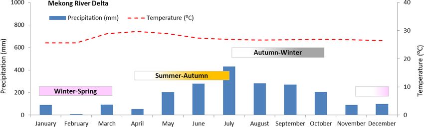
2020; Fig. 1). In 2018, the planted area for spring, autumn 2017).
and winter paddies was 1.6 million ha, 2.3 million ha and In the MRD, favorable environmental conditions with
197.2 thousand ha, respectively. In total, 4.1 million ha of rice ample rainfall, tropical temperatures and fertile alluvial
was planted over the three planting seasons, with 24.5 million soils, coupled with an extensive dike and irrigation sys-
tonnes of rice produced. The delta is home to 17.8 million tem, have facilitated the production of three rice crops an-
people, with many dependent on agriculture for their liveli- nually: winter–spring, summer–autumn and autumn–winter
hoods. That 54 % of Vietnam’s rice is grown in the MRD, and (Table 1; Fig. 2). In 2018, the summer–autumn crop was
most of it is exported overseas, makes it strategically impor- the largest (12.8 million tonnes), and the winter–spring crop
tant for the Vietnamese economy and for global food security was the second-largest (10.8 million tonnes), followed by the
(Chapman et al., 2016; Cosslett and Cosslett, 2018; General autumn–winter crop (909.6 thousand tonnes) (General Statis-
Statistics Office of Vietnam, 2020). Up north, the Red River tics Office of Vietnam, 2020). Compared to the MRD, rice is
Delta (RRD) is the next largest, with a physical delta area of planted biannually in the RRD, first from February to June
1.5 million ha (Fig. 1; Schneider and Asch, 2020). In 2018, (spring crop) and a second time from July to October (au-
1 million ha of planted rice produced 6.3 million tonnes of tumn crop) (Table 1; Fig. 3). The chilly winters preclude the
rice, the equivalent of 14 % of Vietnam’s total rice produc- cultivation of a third crop of rice. Approximately 3.5 million
tion (524.3 and 516.4 thousand ha of rice was planted in tonnes of rice was produced during the spring cropping sea-
the spring and winter seasons, respectively). Approximately son, while 2.8 million tonnes was produced during the au-
21.6 million people live in the RRD, with many also de- tumn season in 2018 (General Statistics Office of Vietnam,
pendent on agriculture (General Statistics Office of Vietnam, 2020).
2020).
Soils in the MRD are highly variable, with alluvial, acid 2.2 Literature review and causal loop diagrams
sulfate and saline soils dominant. Most of the rice grows
in the highly fertile alluvial soils, which are found in only We conducted an online search on Scopus, Web of Science,
30 % of the delta (GRSP, 2013). Conversely, soils in the RRD Google, Google Scholar and individual journal databases to
consist of Holocene delta sediments. These Holocene delta find articles related to the effects of anthropogenic land-use
sediments are relatively fine-grained muds and sands, up to change and natural hazards on rice agricultural systems in the
30 m thick, that are the product of rapid progradation during RRD and/or MRD. Articles related to the environmental im-
the Holocene high sea level stand (Mathers and Zalasiewicz, pacts of these anthropogenic interventions and natural haz-
1999). The Holocene sequence overlies coarse-grained Pleis- ards were included as these tend to explain the environmen-
tocene sediments dominated by braided river and alluvial fan tal processes in detail. A range of literature sources including
deposits formed during the last glacial low sea level stand. peer-reviewed journal articles, book chapters and scientific
The Quaternary sediments are underlain by a > 400 m thick reports from non-governmental organizations were included.
layer of Neogene sedimentary rocks that are made up of con- In addition, we reviewed the bibliographies of our articles to
glomerate sandstone, clay and siltstone (Berg et al., 2007). follow up with any other relevant literature that was not listed
Climatically, the MRD has a tropical monsoon climate in our search. Since sea level rise would affect the viability
with two distinct seasons, a dry season from December to of the two deltas as major rice producing regions (Mainuddin
April and a rainy season from May to November. It is gen- et al., 2011), we also included relevant articles on sea level
erally warm year round, with average temperatures in 2018 rise.
ranging from 26 ◦ C in December, January and February to We obtained 126 articles through our literature search
29 ◦ C in May. The annual rainfall is between 2000 and (cf. Supplement). Every article was considered to be a single
2400 mm (General Statistics Office, 2018; Kotera et al., case study and was read in detail by the lead author. There-
2008). Conversely, the RRD has a tropical monsoon climate after, the natural or anthropogenic drivers and/or the environ-
with three seasons: (1) a hot and wet season from May to mental process that would lead to a change in rice productiv-
September, (2) a cool and dry season from October to Jan- ity directly or indirectly were identified. Adopting a systems-
https://doi.org/10.5194/nhess-21-1473-2021 Nat. Hazards Earth Syst. Sci., 21, 1473–1493, 2021
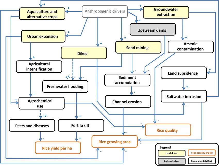
1476                      K. W. Yuen et al.: Interacting effects of land-use change and natural hazards on rice agriculture

Figure 1. Distribution of rice growing areas in the Red River Delta (RRD) in northern Vietnam and the Mekong River Delta (MRD) in
southern Vietnam. Rice growing extents were obtained from Nelson and Gumma (2015).

Figure 2. Climograph for the Mekong River Delta annotated with the winter–spring, summer–autumn and autumn–winter growing seasons.
The color gradient (from faded to dark) represents planting, growing and harvesting times for each crop. Precipitation and temperature data
were taken from the Statistical Yearbook of Vietnam 2018 (General Statistics Office, 2018).

thinking approach, we constructed flow diagrams to identify             quality. This relationship is represented by an arrow, which
and visualize the interconnections among the drivers of rice            indicates the direction of influence, from cause to effect. The
productivity in both deltas.                                            polarity of the arrows (plus or minus) indicates whether the
   We first developed causal links which describe how an an-            effect is increasing or decreasing (Lim et al., 2017). A plus
thropogenic driver would influence rice productivity either             sign indicates that a link has “positive polarity”, and a minus
directly or through an environmental process. We also docu-             sign indicates “negative polarity.” The polarity of the causal
mented if each driver had an increasing or decreasing effect            link between A and B is said to be positive when an increase
on an environmental process that could influence rice pro-              (decrease) in A causes B to increase (decrease). A causal
ductivity by affecting rice growing area, rice yield or rice            link is negative when an increase (decrease) in A causes B

Nat. Hazards Earth Syst. Sci., 21, 1473–1493, 2021                                      https://doi.org/10.5194/nhess-21-1473-2021
K. W. Yuen et al.: Interacting effects of land-use change and natural hazards on rice agriculture                                   1477

Figure 3. Climograph for the Red River Delta annotated with the spring and autumn growing seasons. The color gradient represents planting,
growing and harvesting times for each crop. Precipitation and temperature data were taken from the Statistical Yearbook of Vietnam 2018
(General Statistics Office, 2018).

Table 1. Rice planting, growing and harvesting periods in the Mekong River Delta and the Red River Delta in Vietnam.

                                                Planting                           Harvesting
                                      Onset     Peak       End           Onset      Peak        End      Growing period
                 Mekong River Delta
                 Winter–spring        1 Nov     30 Nov     30 Dec        15 Feb     25 Mar      30 Apr       115–120 d
                 Summer–autumn        15 Mar    15 Apr     15 May        20 Jun     20 Jul      25 Aug        95–100 d
                 Autumn–winter        30 Jun    20 Jul     20 Aug        5 Oct      25 Oct      30 Nov        95–100 d
                 Red River Delta
                 Spring               25 Jan    10 Feb     25 Feb        5 Jun      15 Jun      25 Jun       115–130 d
                 Autumn               15 Jun    1 Jul      20 Jul        5 Oct      25 Oct      10 Nov       105–110 d

to decrease (increase) (Newell and Watson, 2002). We con-              20 km from the main river in the RRD (Ca et al., 1994). As
structed two flow diagrams; the first flow diagram describes           rice plants are unable to thrive in soils with soil salinities ex-
how anthropogenic land-use drivers affect rice growing area,           ceeding 4 g L−1 (V. H. T. Pham et al., 2018), affected farmers
rice yield per hectare and rice quality in the MRD and RRD             have converted their paddy fields into aquaculture ponds to
(Fig. 4), while the second causal flow diagram describes how           cultivate shrimp and fish instead. Other farmers have turned
natural hazards in the MRD and RRD affect rice growing                 to planting salinity-tolerant crops such as coconut, mango
area, rice yield per hectare and rice quality (Fig. 6). The ref-       and sugarcane. In some cases, farmers have opted for a rice-
erences we used are found in the Supplement.                           aquaculture system, whereby rice is planted in the wet sea-
                                                                       son, and fish and shrimp are cultivated in the dry season,
                                                                       when soil salinities are high (Nguyen and Vo, 2017; Pham
3     Results                                                          et al., 2017).
                                                                          Besides environmental factors, the greater profitability of
3.1     Local anthropogenic drivers                                    fruits, vegetables, fish and shrimp also incentivizes farmers
                                                                       to plant more non-rice crops. The income per hectare of
3.1.1    Aquaculture and alternative crops                             rice was USD 146 compared to pomelo (USD 16 844) and
                                                                       coconut (USD 1484) (Hoang and Tran, 2019). Meanwhile,
Both deltas face widespread salinity intrusion that threatens          farmers who practice shrimp–rice rotational systems earned
rice production. In the Mekong River Delta, salinity intrusion         50 % more than those who had two rice crops (Morton, 2020;
is a naturally occurring phenomenon during the dry season.             Schneider and Asch, 2020). In addition, high demand for
Tides from the South China Sea and the Gulf of Thailand                fruits and vegetables for export and from growing urban pop-
bring saltwater inland, and salinity intrudes up to 70–90 km           ulations with greater affluence and knowledge about nutrition
inland as the length of sea dikes is limited. There are 1500 km        also encouraged farmers to diversify from rice monoculture,
of sea and estuary dikes in RRD versus 450 km of sea dikes             leading to possible declines in the overall rice growing area
in the MRD (Le et al., 2018; Preston et al., 2003; Pilarcyzk           (Hai, 2021; Nguyen and Vo, 2017; Fig. 4).
and Nguyen, 2005). Thus, salinity intrusion extends up to

https://doi.org/10.5194/nhess-21-1473-2021                                       Nat. Hazards Earth Syst. Sci., 21, 1473–1493, 2021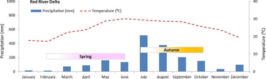
1478                       K. W. Yuen et al.: Interacting effects of land-use change and natural hazards on rice agriculture

Figure 4. Flow diagram showing the key anthropogenic drivers that affect rice production in the two mega-deltas of Vietnam. The drivers
are classified as a local driver if it occurs in the two mega-deltas. Regional drivers are those that occur farther away from the two mega-deltas
but within the Asian region. A plus (+) sign indicates that an increase (decrease) in A causes B to increase (decrease). A negative (−) sign
indicates that an increase (decrease) in A causes B to decrease (increase). Dashed lines with “±” are used when outcomes are unclear. For
example, dikes reduce flooding, but poorly maintained or planned dikes increase flooding instead. In addition, dikes may potentially cause
flooding in unprotected areas. Agrochemical use may reduce the incidence of pests and diseases, but the overuse of chemicals can lead to
pesticide resistance, which may increase outbreaks of pests and diseases.

   Finally, government policies encouraging farmers to move                cultural land was lost per year from 2000–2007, equivalent to
away from growing rice also contributed to the planting of                 a yearly loss of 3 %. By 2025, up to 450 000 ha of agricultural
more non-rice crops on paddy land. As a result, there is                   land is expected to be converted to urban land. Most of this
increased use of paddy land for non-rice crops, orchards,                  land-use conversion occurs in peri-urban areas 5–15 km from
and freshwater and brackish aquaculture (Van Kien et al.,                  the city center. The same peri-urban land is often used to
2020). Using remote sensing to assess land-use and land-                   grow food, flowers and livestock for the urban population in
cover change in the Mekong River Delta, Liu et al. (2020)                  Hanoi. However, this land is considered by local authorities
found that aquaculture had become the second-largest land-                 to be land reserve for urban planning instead of resources for
use type, following planted land. This was facilitated by gov-             food supply (Drebold, 2017; Pham et al., 2015). Most of this
ernment regulations, salt intrusion and higher profitability               peri-urban agricultural land is often forcibly obtained, with
of aquaculture productions. In any case, even though farm-                 minimal compensation given to farmers, and then sold to for-
ers may have moved on from growing rice, many still con-                   eign developers (Drebold, 2017). Similar urban expansion is
tinue to apply excessive quantities of pesticides on their crops           also occurring in Can Tho city in the Mekong River Delta,
(Normile, 2013; Fig. 4).                                                   with corresponding losses of agricultural land (cf. Garscha-
                                                                           gen et al., 2011; Pham et al., 2010). A decline in agricultural
3.1.2   Urban expansion                                                    land means a decline in rice growing areas as well (Fig. 4).
                                                                              High land prices and a shrinking availability of arable land
                                                                           have forced farmers to practice agricultural intensification. In
Rapid urbanization is accelerating the loss of agricultural
                                                                           the RRD, rice production grew more than 25 % from 2000–
land in both the Red River Delta and Mekong River Delta. In
                                                                           2011 without corresponding increases in rice growing areas
Hanoi, a major city in the Red River Delta, 1420 ha of agri-

Nat. Hazards Earth Syst. Sci., 21, 1473–1493, 2021                                          https://doi.org/10.5194/nhess-21-1473-2021
K. W. Yuen et al.: Interacting effects of land-use change and natural hazards on rice agriculture 1479
due to intensified cropping practices involving the use of
new high yielding rice varieties, irrigation during the dry sea-
son and high inputs of agrochemicals (Drebold, 2017; Mor-
ton, 2020). The high pesticide use was reflected in a study
in Nam Dinh Province in the RRD, where 8 out of 12 tar-
get pesticides were found in agricultural soils. In this study,
frequently detected pesticides include isoprothiolane, chlor-
pyrifos and propiconazole, and besides polluting the envi-
ronment, the presence of high concentrations of pesticide
residues also lowers the quality of rice sold for consumption
(Braun et al., 2018; Fig. 4).
In general, pests such as the brown planthopper are nat-
urally occurring and are not a threat at low densities. How-
ever, intensive rice production with high seeding densities
and the use of susceptible varieties create a constant sup-
ply of food, which allows their numbers to balloon. This is
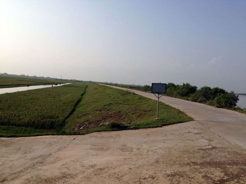
exacerbated by the asynchronous planting, which creates a Figure 5. Example of a river dike for flood control in Nam Dinh
continuous supply of rice plants throughout the year in the Province in the Red River Delta.
Mekong River Delta. In addition, the overuse of nitrogen fer-
tilizers increases the pests’ reproductive potential. Thirdly, A study comparing sediment deposition in areas of high
the excessive use of pesticides also kills the natural ene- and low dikes in An Giang Province found that double-
mies of pests such as spiders, ants, bees, beetles, dragonflies, cropping farmers who cultivate their crops in areas with low
frogs, ladybugs and wasps. Besides killing the natural preda- dikes have an average of 2.5 cm of sediment deposition. This
tors of rice pests, the pests targeted by the pesticides may also deposition by floodwaters improved their average annual in-
become resistant to the pesticide. As a result, higher doses of put efficiency by 0.3 t of yield per tonne of fertilizer. Con-
the pesticide may be needed to kill them in the future. For versely, triple-cropping farmers had very little deposition, av-
example, killing planthoppers now requires a pesticide dose eraging 0.5 cm as the high dikes kept floodwaters out. Some
500 times larger than was needed in the past (Normile, 2013). deposition was found only if there had been a dike breach
The overuse of pesticide is due to a combination of factors which also caused crop damage (Chapman et al., 2016). The
such as insufficient knowledge of its proper use as well as value of flood deposits is reiterated by the study of Manh
aggressive marketing by agrochemical companies (Bottrell et al. (2015), which estimated that the annual deposition of
and Schoenly, 2012; Normile, 2013; Sebesvari et al., 2011). sediment-bound nutrients can naturally supply over half of
The dashed lines in Fig. 4 show that pesticide use may not the fertilizers needed for a season of rice crop. The provision
necessarily reduce the incidence of pests and diseases if ex- of “free” fertilizers by the encroaching floodwaters benefits
cessive volumes were applied. the less economically endowed farmers who must purchase
artificial fertilizers to maintain yields (Chapman et al., 2017;
3.1.3 Dikes Kondolf et al., 2018; Fig. 4).
However, poorly planned and/or maintained dikes are not
Wet-season flooding is a naturally occurring phenomenon only functionally ineffective against floodwaters or coastal
in the two deltas of Vietnam (Chan et al., 2012, 2015). To surges; they may also become an amplifier of destruction
facilitate the planting of rice during the wet season, flood when their presence creates a false sense of security which
prevention dikes were constructed to keep floodwaters out results in intensive development of low-lying areas (Mai et
(Fig. 5). The MRD has more than 13 000 km of flood preven- al., 2009; Tran et al., 2018). In addition, areas unprotected
tion dikes, of which 8000 km are low dikes below 2 m tall. by dikes may be more vulnerable to flooding as the excess
These low dikes were mostly constructed before 2000 to de- water has to flow somewhere. Using a GIS-linked numeri-
lay the entry of floodwaters at the start of the monsoon season cal model, Le et al. (2007) confirmed that engineering struc-
to allow two rice crops to be grown. A severe flood in 2000 tures in the MRD increased water levels and flow velocities
provided the impetus for river dikes to be heightened to 3.5 m in rivers and canals. This in turn increased the risk of flood-
to completely keep floodwaters out. These high dikes have ing in both non-protected areas and protected areas (due to
facilitated triple-cropping in the MRD, particularly in Dong dike failure). Dashed lines are used in Fig. 4 to show that
Thap and An Giang provinces (Chapman et al., 2016; Howie, dikes do not necessarily reduce flooding.
2005; Le et al., 2018; Triet et al., 2017). However, the pres-
ence of high dikes in the MRD has reduced the supply of fer-
tile alluvium, increasing the need for artificial fertilizers and
pesticides to maintain yields (Chapman et al., 2017; Fig. 4).
https://doi.org/10.5194/nhess-21-1473-2021 Nat. Hazards Earth Syst. Sci., 21, 1473–1493, 20211480 K. W. Yuen et al.: Interacting effects of land-use change and natural hazards on rice agriculture
Likewise, the RRD is also heavily diked, with 3000 km of unclear as there is almost no research on this issue. We did
river dikes (Fig. 5), but unlike the MRD, high dikes are ab- however come across an article in a Vietnamese newspaper
sent (Pilarcyzk and Nguyen, 2005). Besides river and flood about rampant sand mining in the Red River and how min-
control dikes, there are also sea dikes and salinization pre- ing operations have caused erosion in nearby villages (Chinh,
vention dikes in both deltas to protect the area from salinity 2018). Similar to the situation in the MRD, the authorities
intrusion. There are 1500 km of sea and estuary dikes in the have turned a blind eye to this illegal business (Bravard and
RRD. In the MRD, there are 1290 km of salinization preven- Gaillot, 2013; Chinh, 2018).
tion dikes and 450 km of sea dikes (Le et al., 2018; Pilarczyk
and Nguyen, 2005; Fig. 4). 3.1.5 Groundwater extraction
3.1.4 Sand mining Another example of an anthropogenic development creating
other interrelated problems is that of groundwater extraction.
Sand mining is carried out on a large scale in the Mekong While groundwater extraction has increased the availability
(Kondolf et al., 2018). Fueled by demand from reclamation, of water for human activities, it has exacerbated land subsi-
export and construction, 55.2 million tonnes of sediment dence, which has increased the severity and extent of salt-
was extracted from the Mekong main stem in Laos, Thai- water intrusion and reduced the suitability of land for rice
land, Cambodia and Vietnam from 2011 to 2012 (Bravard cultivation (Fig. 4). Minderhoud et al. (2017) developed a
and Gaillot, 2013; Robert, 2017). A more recent analysis of 3D numerical groundwater flow model of the MRD surface
bathymetric maps and the local refilling processes by Jor- and found that subsidence rates from groundwater extraction
dan et al. (2019) put the amount of sand extracted from the were between 1.1 and 2.5 cm yr−1 . The model also showed
Mekong River Delta in 2018 at 17.77 Mm3 . that 25 years of groundwater extraction since 1991 had re-
Besides removing large quantities of riverbed sediments, sulted in a cumulative average of 18 cm of subsidence, with
sand mining operations have created numerous pits and some hotspots recording over 30 cm of subsidence. Land sub-
pools. These pits and pools, which can be up to 45 m deep, sidence from excessive groundwater extraction acts as a cat-
then become sediment traps, trapping bed loads from up- alyst that increases vulnerability to saltwater intrusion and
stream reaches and preventing them from traveling down- reduces the availability of land suitable for rice production.
stream and contributing to the continued presence and Moreover, rice crops become contaminated with arsenic
growth of the delta. In addition, bed incision also occurs when arsenic-rich groundwater used for non-agricultural use
as the water is sediment-starved. The down-cutting of river- is discharged into rivers, and the river water is used for rice ir-
banks can propagate upstream and downstream from the ex- rigation (Lan and Giao, 2017; Minderhoud et al., 2018). High
traction sites for many kilometers, in turn affecting river arsenic concentrations in groundwater seem to be of natu-
ecosystems over a large area (Kondolf et al., 2018). This bank ral origin. In the Mekong River Delta, naturally occurring
incision results in land loss, which threatens rice growing ar- biochemical and hydrological processes cause As to be re-
eas (Fig. 4). leased from Fe oxides in rocks and sediments into groundwa-
Aggressive sand mining also disrupts natural flooding. A ter reservoirs (Fendorf et al., 2010). In addition, deep ground-
recent study of the effects of riverine mining on flood fre- water extraction causes interbedded clays to compact and ex-
quency in the Long Xuyen Quadrangle (LXQ) in the Mekong pel water containing dissolved As (Erban et al., 2013). Crop
River Delta found that flood frequency had dropped by 7.8 % quality is reduced when the arsenic-enriched water is de-
from 2005–2015. Water levels at local gauge stations also posited on topsoils and absorbed by rice plants during growth
showed an overall decreasing trend, indicating that the low- (Rahman and Hasegawa, 2011; Fig. 4).
ering of the riverbed had reduced the frequency of flooding. Similarly, prevalence of groundwater extraction is also
Disrupted flood regimes result in reduced volumes of water high in the Red River Delta. Approximately 70 % of the
and sediments for agricultural production. In addition, flood- population living in the RRD accesses water from Holocene
waters typically deposit fertile sediments while flushing the and Pleistocene aquifers (Berg et al., 2007; Winkel et al.,
pesticides and fertilizers accumulated from intensive agricul- 2011). Groundwater in the Red River Delta is also contam-
tural production. When the flood frequency decreases, the inated with high levels of As due to reductive dissolution
frequency at which farmlands benefit from this natural soil of As from iron oxyhydroxides in buried sediment (Berg et
quality enhancement decreases. Consequently, soil fertility al., 2007; Luu, 2019). Berg et al. (2007) sampled 196 tube
may decrease over time and lead to declines in rice yields un- wells randomly over a 700 km2 area in the Red River Delta,
less artificial fertilizers are added (Park et al., 2020; Fig. 4). and the concentrations of As in groundwater ranged from
While there are several studies on the diffuse, yet insidious 1 to 3050 µg L−1 , with an average of 159 µg L−1 . Separately,
nature of sand mining in the Mekong (cf. Bravard and Gail- Winkel et al. (2011) collected 512 water samples from pri-
lot, 2013; Brunier et al., 2014; Jordan et al., 2019; Kondolf vate wells in the Red River floodplain and found As concen-
et al., 2018; Park et al., 2020; Robert, 2017; Schmitt et al., trations varying from < 0.1 to 810 µg L−1 , with 27 % of the
2017), the extent of sand mining in the Red River Delta is samples exceeding the WHO guideline value of 10 µg L−1 .
Nat. Hazards Earth Syst. Sci., 21, 1473–1493, 2021 https://doi.org/10.5194/nhess-21-1473-2021K. W. Yuen et al.: Interacting effects of land-use change and natural hazards on rice agriculture 1481
The high concentrations of As reduce the quality of rice har- sedimentation would decrease by about 21 % to 96 %, while
vested in the RRD if As gets into soils and river waters indi- sediment load supplied to the sea at the river will diminish by
rectly through the usage of As-enriched groundwater (Fig. 4). 1 % to 95 %, with the extreme values representing full dam
In a study on As accumulation in white rice from the Red build-up. Even if dam construction was limited to the river
River region in Vietnam, Phuong et al. (1999) reported As tributaries instead of the main stem, the cumulative sediment
values of between 0.03 and 0.47 µg g−1 d wt with the mean trapped could be as high as 68 %, meaning that only about
value at 0.21 µg g−1 d wt. The mean value was higher than the 32 % of the sediment load would reach the Mekong River
mean value reported for Thai rice (0.14 µg g−1 d wt; range: Delta (Kondolf et al., 2014).
0.01 to 0.39 µg g−1 ) (Meharg et al., 2009). Indeed, Binh et al. (2020) found that the suspended sed-
Lastly, although high As concentrations in groundwater iment loads in the MRD had decreased by 74.1 % in 2012–
are common in the RRD (cf. Berg et al., 2007; Luu, 2019; 2015 primarily due to six mainstream dams in the Lancang
H. V. Pham et al., 2018; Winkel et al., 2011), there is no re- cascade in China. In particular, the Manwan and Dachaoshan
search on (groundwater induced) land subsidence in the Red dams contributed to 32 % of the reduction. In addition,
River Delta. Thus, the magnitude of land subsidence in the from 2014–2017, the average incision rate of the Tien River
delta is uncertain and should be an area for future research. in the MRD was 3 times higher than the previously recorded
value. Sand mining was responsible for a maximum of
3.2 Regional anthropogenic drivers 14.8 % of the annual riverbed incision, while the remainder
was caused by hydropower dams upstream.
3.2.1 Upstream dams The deleterious impacts of dams on sediment loads can
also be found in the Red River Delta in spite of the smaller
The Mekong River originates in the Tibetan Plateau and number of dams. While the Hoa Binh dam is located on a
flows through China, Myanmar, Laos, Thailand, Cambo- tributary of the Red River in Vietnam, its large size has in-
dia and southern Vietnam. To meet growing demands for fluenced suspended sediment distribution in the lower Red
electricity, many small- and large-scale hydropower projects River basin. For example, an analysis of the suspended sedi-
have been commissioned in each country to take advantage ment concentration over a 50-year period from 1960 to 2010
of this supposedly green and clean source of energy (Nhan showed that yearly suspended sediment flux had dropped by
and Cao, 2019; Manh et al., 2015). A total of 241 dams 61 % at Son Tay near Hanoi (Vinh et al., 2014). Similarly,
have been completed in the entire Mekong basin, with an- Duc et al. (2012) calculated that the suspended sediment bud-
other 29 under construction. A further 91 are currently be- get at Son Tay and Hanoi hydrological monitoring stations
ing planned. These 361 dams consist of 176 hydropower was reduced by 56 % after the Hoa Binh dam became oper-
dams and 185 irrigation dams. Of the 364 dams in the ational in 1989. The reduction in sediment loads at the Red
Mekong, 20 are in Vietnamese territory (WLE Mekong River Delta would likewise have a similar impact on delta
CGIAR, 2020a). Conversely, the Red River originates in size and rice growing areas.
Yunnan Province in China and flows towards northern Viet- Besides a change in sediment loads, dams also alter stream
nam. It is less heavily dammed, with a total of 105 dams in discharge and water levels, with concurrent effects on wa-
China and Vietnam. There are 25 hydropower dams, 3 multi- ter supplies (not shown in Fig. 4). When water levels are
purpose dams and 9 irrigation dams in the Red River basin in high during the rainy season, dams can be used to impound
Vietnam (Vinh et al., 2014; WLE Mekong CGIAR, 2020b). the excess water in the reservoir behind. During the dry sea-
While there are no dams in the Mekong River Delta or the son, when water levels are lower, the dams can release wa-
Red River Delta due to their relatively flat elevation, up- ter downstream. In doing so, dams increase dry-season dis-
stream dam development influences downstream regions in charge and decrease wet-season discharge. The modification
many ways, with the environmental impacts extending far of seasonal water flows is problematic as changes in natu-
beyond the dam itself (Kondolf et al., 2014). ral flow patterns, such as higher flows in the dry season and
Firstly, a substantial amount of coarse sand, gravel and lower flows in the wet season, would affect rice production
suspended sediment is impounded in reservoirs behind the as rice growing calendars are currently linked to the natu-
dams instead of being transported downstream. This dimin- ral fluctuations in high and low flows (Robert, 2017). Hence,
ished sediment load may aggravate erosion downstream from changes in water levels due to anthropogenic interventions
the dam (Nhan and Cao, 2019; Fig. 4). Using a network may create unfavorable conditions for crop growth if plant-
model, under a “definitive future” scenario of 38 new dams, ing calendars remain unchanged. In addition, lowered water
the cumulative sediment reduction in the Mekong River levels during dry seasons due to upstream water impound-
Delta would be 51 %. Conversely, under full build-up of ment can also lead to increased saltwater intrusion and create
133 new dams, only 4 % of the pre-dam sediment load will unfavorable growing conditions for rice farmers.
reach the delta (Kondolf et al., 2014). Manh et al. (2015)
also reached similar conclusions with a quasi-2D hydrody-
namic model of suspended sediment dynamics. Floodplain
https://doi.org/10.5194/nhess-21-1473-2021 Nat. Hazards Earth Syst. Sci., 21, 1473–1493, 20211482 K. W. Yuen et al.: Interacting effects of land-use change and natural hazards on rice agriculture
Figure 6. Flow diagram showing the natural hazards that affect rice production in the two mega-deltas of Vietnam. Local drivers refer to
natural hazards that occur within the two mega-deltas. Although sea level rise has implications on a local scale, it is considered a global
driver as it occurs on a global scale. The effect of flooding on rice growing areas is variable as other factors that affect crop mortality include
the type of rice grown, the stage of rice growth, and the depth and length of submergence in floodwaters.
3.3 Local natural-hazard drivers reported that the RRD experienced droughts from the end
of 1998 to April 1999, which affected 86 140 ha of rice. An-
3.3.1 Drought other drought occurred from January to February 2004, with
the water level of the Red River at the lowest in 40 years. Low
Droughts do not result solely from a lack of rainfall; they water levels were also reported in 2010; however drought
can also result from changes in the arrival of rains and the conditions and saltwater intrusion were more severe in the
length of the wet season (Adamson and Bird, 2010; Lassa et MRD (Overland, 2010). The effect of droughts on rice agri-
al., 2016). Vietnam was affected by droughts in 1997–1998, culture – reduced yields from a lack of water and salinity
2002–2003, 2009–2010 and most recently in 2015–2016. intrusion – would also be similar in the RRD.
The 2015–2016 drought was the most severe in 90 years
(Grosjean et al., 2016). All 13 provinces in the Mekong River 3.3.2 Freshwater flooding
Delta were affected by the 2015 drought. Besides a lack of
water for irrigation, the drought caused saltwater to intrude Ranked as the second most severe natural hazard after ty-
up to 70 km inland. Cumulatively, the drought and accompa- phoons, freshwater floods are caused by overflowing rivers or
nying saltwater intrusion damaged 400 000 ha of rice crops, heavy monsoonal rains or associated with heavy rain from ty-
including 50 000 ha of paddy in Kien Giang and Ca Mau phoons (Chan et al., 2012, 2015; Hung et al., 2012; McElwee
provinces in the MRD (Grosjean et al., 2016; Nguyen, 2017). et al., 2017). Theoretically, flooding reduces rice growing ar-
Although there is no research on how droughts and salinity eas, but it is simplistic to assume that flooded fields result in
intrusion have affected rice quality in Vietnam, research from immediate loss of rice crops. A study by Kotera et al. (2005)
elsewhere has shown that water shortages and salt stress in- in the RRD showed that the type of rice, stage of rice growth,
duce physiochemical alterations which affect the rice grains and lengths and depths of submergence were factors that in-
produced (Pandey et al., 2014; Razzaq et al., 2019; Fig. 6). fluence the survival rates of rice crops. For example, the local
Compared to the MRD, research and reports on droughts variety Moc Tuyen was less resilient to submergence than
in the Red River Delta are scarce. The UNW-DPC (2014) the two other genetically improved high-yielding varieties.
Nat. Hazards Earth Syst. Sci., 21, 1473–1493, 2021 https://doi.org/10.5194/nhess-21-1473-2021K. W. Yuen et al.: Interacting effects of land-use change and natural hazards on rice agriculture 1483
In terms of growth stage, rice plants at the tillering stage are et al. (1998) found that the maximum storm surge is usually
more likely to succumb to submergence than those at the veg- between 1 to 1.5 m a.m.s.l. (above mean sea level). In short,
etative stage. Plants fully submerged for short durations (2 d) rice production will be adversely affected by strong winds
also had lower chances of survival than those that were par- and widespread flooding from heavy precipitation and storm
tially submerged in floodwaters for longer durations (up to surges in the event of a typhoon. Saltwater flooding may re-
8 d). As such the effect of flooding on rice growing areas is duce rice growing areas as rice is not adapted to withstand
variable as other factors that affect crop mortality include the prolonged submergence and/or saline conditions. Addition-
type of rice grown, the stage of rice growth, and the depth ally, strong winds damage rice plants, with both effects con-
and length of submergence in floodwaters (Fig. 6). tributing to a reduction in rice yields (Fig. 6).
Although severe flooding can disrupt agricultural activi- Although a stronger typhoon usually brings higher wind
ties, moderate levels of freshwater flooding bring benefits speeds, more rainfall, larger waves and higher storm surges
to (rural) farmers (EEPSEA, 2011). Floodwaters from rivers (Larson et al., 2014), the quantity of agricultural losses de-
improve agricultural productivity by depositing nutrient-rich pends on factors such as landfall location(s) and whether the
flood sediments on agricultural soils (Chapman et al., 2016). typhoon occurs during the vulnerable heading or harvesting
In addition, floods wash away contaminants, purify and periods (Masutomi et al., 2012). For example, Typhoon Miri-
recharge aquifers, kill pests, and mitigate saltwater intrusion nae (2016), which made landfall in Nam Dinh as a tropical
(EEPSEA, 2011; Hoang et al., 2018; Fig. 6). Aquatic re- storm, damaged or submerged 225 216 ha of rice. Meanwhile
sources such as fish, crabs and snails also come in with the Typhoon Nesat (2011) made landfall in Hai Phong with a
floodwaters, which local farmers can collect to supplement similar intensity and caused only 3500 ha of rice damage.
their incomes. Besides growing rice, it is also possible to cul- Conversely, Typhoon Kalmai (2014) made landfall in Quang
tivate vegetables, fish, prawns and ducks in the flooded fields Ninh as a slightly stronger category 1 storm and caused
(Nguyen and James, 2013). Towards the end of the flooding 20 000 ha of rice damage (Nhân Dân, 2014; United Nations
season and the start of the rice cultivation season, floodwa- Vietnam, 2016; Viêt Nam News, 2011).
ters provide the water needed to start growing rice (Hoa et An average of five to six typhoons affect Vietnam be-
al., 2008). tween June and November every year (Larson et al., 2014;
While there are investments in flood prevention measures Nguyen et al., 2007). Typhoon activity shifts from the north
with the construction and upgrading of river dikes, the con- to the south as the year progresses. Therefore, peak activ-
struction and dredging of reservoirs and drainage canals, and ity in the north and southern part of Vietnam is in August
the raising of roads and embankments, recent floods have and November, respectively (Imamura and Van To, 1997).
caused substantial agricultural losses as current measures We reviewed the Digital Typhoon (2021) database and found
have proven to be inadequate (Hoa et al., 2008; Pilarczyk 303 typhoons that came within 500 km of Vietnam’s coast-
and Nguyen, 2005). In 2018, 39 000 ha of rice in the RRD line from 1995 to 2018. A total of 29 cyclones made their
was inundated by heavy rains and floods triggered by Ty- initial landfall in the Red River Delta, while only 4 cyclones
phoon Son-Tinh (VNA, 2018a). Similarly, due to a lack of made landfall in the Mekong River Delta during the study pe-
embankments and/or poor construction and maintenance of riod – one each in 1973, 1996, 1997 and 2006 (unpublished
existing embankments, more than 2000 ha of rice was lost results). Although the MRD is less prone to typhoons, two
during the annual floods in 2018. An Giang Province was the of the most recent typhoons caused significant damage de-
worst-affected, losing 1270 ha of rice (VNA, 2018b). spite each being classified as a tropical storm upon landfall.
Typhoon Linda (1997) caused some 349 232 ha of rice to be
3.3.3 Typhoons submerged, while Typhoon Durian (2006) damaged 6978 ha
of agricultural land (International Federation of Red Cross
Typhoons are the most severe natural hazard that affects Viet- and Red Crescent Society, 2006; UN Department of Human-
nam. When a typhoon occurs, affected areas are exposed to itarian Affairs, 1997).
strong winds of up to 50 m/s and up to 300 mm of rainfall Lastly, typhoons may not necessarily be bad all the time.
in a day. As the rainy season in Vietnam coincides with the Darby et al. (2016) combined suspended sediment load data
typhoon season, widespread flooding can be expected from from the Mekong River with hydrological model simulations
heavy rain and overflowing rivers (CCFSC, 2005; Mai et to examine the role of typhoons in transporting suspended
al., 2009; K.-A. Nguyen et al., 2019). Storm surges can also sediments and found that one-third (32 %) of the suspended
occur when high winds pushing on the ocean’s surface are sediment reaching the delta is delivered by runoff generated
combined with the effect of low pressure in the center of by rainfall associated with typhoons. When a typhoon affects
a typhoon (Takagi et al., 2013). A study of typhoon disas- areas upstream, the land receives higher-than-usual levels of
ters in Vietnam since 1950 showed that half of the 450 ty- rainfall, which may trigger landslides. This sediment can be
phoons recorded during the study period were accompanied transferred into rivers and delivered downstream. While the
by a storm surge of over 1 m, and 11 % were over 2.5 m high role of tropical typhoons in sediment mobilization is unclear
(Imamura and Van To, 1997). In the Red River Delta, Quynh given the lack of research in this area, such findings have
https://doi.org/10.5194/nhess-21-1473-2021 Nat. Hazards Earth Syst. Sci., 21, 1473–1493, 20211484 K. W. Yuen et al.: Interacting effects of land-use change and natural hazards on rice agriculture
important implications for the MRD as sand mining and up- is rising sea levels. Globally, the Intergovernmental Panel
stream dams have caused sharp declines in fluvial sediment on Climate Change (IPCC) has projected sea levels to rise
loads, with corresponding impacts on channel incision and from a rate of 3.2 mm yr−1 from 1993 to 2010 to as much as
flood frequencies (Brunier et al., 2014; Rubin et al., 2015; 10 mm yr−1 or more by 2010 (Church et al., 2013). This may
Park et al., 2020). result in a 0.98 m increase in sea level by 2100 (Lassa et al.,
2016). To quantify sea level rise locally, observations at tide
3.3.4 Pests and diseases gauges across Vietnam have recorded an average yearly in-
crease of 3.3 mm from 1993–2014 (Hens et al., 2018). SLR
Examples of pests that occur in rice fields of Vietnam in- may also increase the risk of storm surges (Hanh and Fu-
clude the brown planthopper (BPH; Nilaparvata lugens Stål), rukawa, 2007). In the Red River Delta, Neumann et al. (2015)
whitebacked planthopper (WBPH; Sogatella furcifera Hor- found that sea level rise through 2050 could reduce the recur-
vath) and small brown planthopper (SBPH; Laodelphax stri- rence interval of the current 100-year storm surge with a 5 m
atellus Fallen). These planthoppers not only damage plants height to once every 49 years. Inadequately constructed and
by ingesting its sap; they also transmit pathogenic viruses poorly maintained dikes and embankments may be breached,
that kill the plants. The BPH is a vector for the rice grassy resulting in saltwater flooding, which will damage rice grow-
stunt virus (RGSV) and the rice ragged stunt virus (RRSV); ing areas and other properties (Hanh and Furukawa, 2007;
the WBPH transmits the southern rice black streaked dwarf Fig. 6).
virus (RBSDV), while the SBPH vectors the rice stripe Rising sea levels coupled with accelerated coastal subsi-
virus (RSV) and the RBSDV (Bottrell and Schoenly, 2012; dence caused by excessive groundwater extraction will cause
Matsukawa-Nakata et al., 2019). Other pests that affect large portions of the low-lying RRD and MRD to be inun-
rice include parasitic worms called nematodes. Root nema- dated and flooded (Allison et al., 2017). This facilitates the
todes that affect deepwater and irrigated rice fields in the infiltration of saltwater into groundwater aquifers, and this
MRD include Hirschmanniella oryzae (rice root nematode), may increase salinity gradients in the MRD and RRD. In par-
Hirschmanniella mucronata and Meloidogyne graminicola ticular, salinity intrusion will worsen during the dry season.
(rice root knot nematode). Stem nematodes like the Dity- Approximately 1.8 million ha in the MRD is already affected
lenchus angustus infect floating, deepwater and rainfed low- by dry-season salinity, of which 1.3 million ha is affected by
land rice in the MRD (Nguyen and Prot, 1995). Other signif- salinity levels above 5 g L−1 (Lassa et al., 2016). This area
icant pests of rice in Vietnam include rice leaf folders, rice is predicted to increase to 2.2 million ha with rising sea lev-
thrips and stem borers (Sebesvari et al., 2011). Meanwhile, els. Meanwhile, in the northeastern part of the RRD, the 1 %
common rice diseases include bacterial leaf blight, bakanae, salinity contour has migrated landwards by 4 to 10 km (Hanh
black rot of grain, brown spot, leaf yellowing disease, neck and Furukawa, 2007). Increased soil salinization leads to a
blast, rice blast disease, root rot, sheath blight, sheath rot loss of land available for rice production (Fig. 6). Though
and stem rot (Pinnschmid et al., 1995; Sebesvari et al., 2011; there are already sea dikes and saline water intrusion sluices
Trung et al., 1995; Kim et al., 1995). in both the MRD and RRD to reduce incursions of seawater
Between 2005 and 2008, rice production in the Mekong (Braun et al., 2018; Tuong et al., 2003), they may be inade-
River Delta was severely reduced by outbreaks of brown quate if they are not well maintained and upgraded.
planthopper and the associated virulent diseases. The prob-
lem was particularly severe in An Giang, Dong Thap and
Tien Giang provinces, with more than 50 % of the cultivated 4 Discussion
areas affected (Berg and Tam, 2012). In 2009, the south-
ern rice black streaked dwarf virus affected 19 provinces in 4.1 Untangling complexity
northern Vietnam, including those in the Red River Delta.
More than 80 % of the rice fields in Nam Dinh, Nghe An, Relevant information on the different drivers and environ-
Quang Ninh and Thai Binh provinces were infested, and mental processes affecting rice production in Vietnam is
yield was non-existent (Hoang et al., 2011). In short, an in- fragmented in a range of academic and non-academic sources
crease in pest and/or disease outbreaks will likely cause a (Bosch et al., 2007), making it difficult for policymakers and
reduction in rice yield (Fig. 6). managers to have a good overview of the reinforcing and
interdependent processes and issues affecting food security
3.4 Global natural-hazard driver in Vietnam. Using a systems-thinking approach, we amalga-
mated the various drivers and created flow diagrams to con-
Sea level rise (SLR) sider how rice productivity can be positively or negatively
impacted by the various drivers and environmental processes
Besides creating new environmental challenges, pre-existing (Figs. 4 and 6). Rice growing areas are negatively affected by
threats to rice production and food security will be exacer- the expansion of aquaculture and alternative crops and urban
bated by climate change. One of the effects of climate change expansion. But with agricultural intensification facilitated by
Nat. Hazards Earth Syst. Sci., 21, 1473–1493, 2021 https://doi.org/10.5194/nhess-21-1473-2021You can also read