Seven Good Reasons for Integrating Terrestrial and Marine Spatial Datasets in Changing Environments - MDPI
←
→
Page content transcription
If your browser does not render page correctly, please read the page content below
water
Review
Seven Good Reasons for Integrating Terrestrial and
Marine Spatial Datasets in Changing Environments
Mariacristina Prampolini 1 , Alessandra Savini 2, * , Federica Foglini 1 and Mauro Soldati 3
 1   Institute of Marine Sciences, National Research Council, 40129 Bologna, Italy;
     mariacristina.prampolini@bo.ismar.cnr.it (M.P.); federica.foglini@bo.ismar.cnr.it (F.F.)
 2   Department of Earth and Environmental Sciences, University of Milano Bicocca, 20126 Milano, Italy
 3   Department of Chemical and Geological Sciences, University of Modena and Reggio Emilia,
     41125 Modena, Italy; mauro.soldati@unimore.it
 *   Correspondence: alessandra.savini@unimib.it; Tel.: +39-02-64482079

 Received: 10 June 2020; Accepted: 3 August 2020; Published: 6 August 2020

 Abstract: A comprehensive understanding of environmental changes taking place in coastal regions
 relies on accurate integration of both terrestrial and submerged geo-environmental datasets. However,
 this practice is hardly implemented because of the high (or even prohibitive) survey costs required
 for submerged areas and the frequent low accessibility of shallow areas. In addition, geoscientists
 are used to working on land or at sea independently, making the integration even more challenging.
 Undoubtedly new methods and techniques of offshore investigation adopted over the last 50 years and
 the latest advances in computer vision have played a crucial role in allowing a seamless combination of
 terrestrial and marine data. Although efforts towards an innovative integration of geo-environmental
 data from above to underwater are still in their infancy, we have identified seven topics for which
 this integration could be of tremendous benefit for environmental research: (1) geomorphological
 mapping; (2) Late-Quaternary changes of coastal landscapes; (3) geoarchaeology; (4) geoheritage
 and geodiversity; (5) geohazards; (6) marine and landscape ecology; and (7) coastal planning and
 management. Our review indicates that the realization of seamless DTMs appears to be the basic
 condition to operate a comprehensive integration of marine and terrestrial data sets, so far exhaustively
 achieved in very few case studies. Technology and interdisciplinarity will be therefore critical for the
 development of a holistic approach to understand our changing environments and design appropriate
 management measures accordingly.

 Keywords: terrestrial geomorphology; submarine geomorphology; white ribbon; paleo-geography;
 coastal management

1. Introduction
     Ongoing climate changes are producing remarkable impacts worldwide [1]. From the melting of
polar ice sheets, and the consequent sea-level rise, to the increasing occurrence of extreme weather
events [2], climate changes are notably modifying and/or threatening Earth’s environment and
ecosystems. Considerable effects have been observed especially in coastal regions [3], which host
more than 10% of global population [4]. Coastal erosion, flood risk, increased landslide occurrence
and wetland loss are expected to intensify in the coming decades [2], posing serious threats for
inhabited areas and environmental assets. A major issue is the uncertainty about the extent and
timing of climate-driven impacts, which has often reflected in a “non-immediate” adoption of effective
prevention measures and in a non-sustainable coastal management, producing negative socio-economic
consequences [2,5].

Water 2020, 12, 2221; doi:10.3390/w12082221                                       www.mdpi.com/journal/water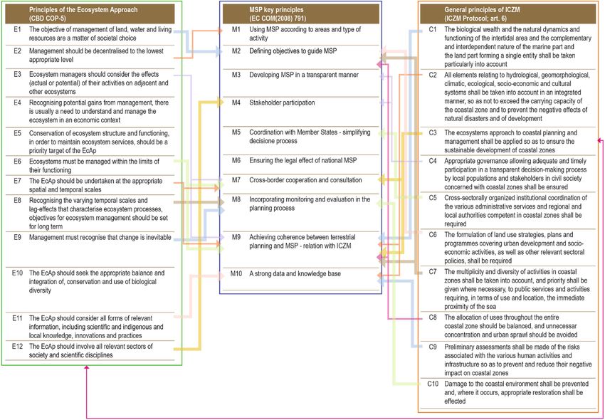
Water 2020, 12, 2221                                                                                    2 of 35

        Coastal zones are the interface between the terrestrial and marine environments and together
with nearshore ones are affected by multiple physical processes that originate in both the terrestrial
(i.e., fluvial) and marine (i.e., waves and tides) environments. These processes drive geomorphic change,
which determines increasingly hazardous conditions (e.g., unstable cliffs, lowlands susceptible to
floods) in coastal areas in relation to climate changes and economic development [3,4]. A comprehensive
understanding of environmental changes taking place on coastal regions, whose ecosystems are highly
productive and very susceptible to changing environmental conditions, relies on an accurate integration
of both terrestrial and submerged geo-environmental datasets. This practice is often lacking in coastal
management and that still need to be addressed in many regions of the world, where climate change,
rising sea levels, tectonic and marine geohazard of different nature are pressing harder year by year
and resources need to be more carefully managed (e.g., [6]).
        The absence of a seamless spatial data framework prevents in particular a standard procedure
for locating and referencing spatial data across the land-marine interface. Different accessibility and
investigation costs are the main causes for the huge disparity in size and quality among terrestrial and
marine spatial datasets used in environmental research, especially in geomorphological investigation.
Landscapes and landforms of terrestrial and marine areas have been traditionally investigated
separately, and scientific communities used to working on land—coastal zone included—or at sea
independently. On land, geomorphological mapping has been extensively used as a primary method
to visualize and analyze Earth surface features ever since early geomorphological research. Taking
advantage of the cartographical potentials of Geographic Information Systems (GIS) and the increasing
availability of remote sensing tools, data, and products—especially high-resolution aerial and satellite
imagery and derived datasets such as Digital Elevation Models (DEMs) and Digital Terrain Models
(DTM)—geomorphological maps have been largely produced for many emerged sectors of Earth’s
surface. Besides being crucial for georisk assessment and land management, detailed geomorphological
maps provided reference data for a variety of applied sectors of environmental research, such as
landscape ecology, forestry or soil science and spatial planning [7,8]. In the terrestrial domain, the need
to share and integrate spatial data for more efficient resource information management has been
recognized for over a decade. On the contrary, although the latest developments in submarine
acoustic remote sensing [9] have offered increasingly detailed DEMs for the submerged domain of
the Earth’s surface, only less than 18% of the world’s seafloor has been surveyed with a resolution of
30 arc-second, while less than 9% of world’s seafloor has been mapped with high-resolution multi-beam
sonar [10–15]. Undoubtedly, new technologies are revealing more of the seafloor than ever before.
The recent development of marine robotics, along with the critical improvement in optical underwater
imaging systems (among which the use of hyperspectral cameras in the submarine realm, [16]) and
computer vision made it possible to obtain, for the first time, 3D optical reconstruction and a real
perception of underwater environments. This allowed for the first time to make more accessible the
scientific understanding of submarine processes and environments, not only to scientists but even to
the community, with a renewed appreciation of their heterogeneity. Nevertheless, a comprehensive
characterization and categorization of submarine landforms and processes is still in its infancy,
notwithstanding the important applications for the whole spectrum of submarine geomorphological
research [9].
        The attention recently paid to the integration of terrestrial and marine spatial datasets for different
purposes is notable, although the generation of seamless DEMs and DTMs, based on a reliable
integration of onshore, nearshore, and offshore data, is often a challenge for the most part of the coastal
regions, especially due to technical issues often associated with the integration of multisource data
(i.e., differences in resolution, precision, and accuracy among the datasets available). Addressing
this process relies on the development of innovative approaches in using methods and techniques
traditionally developed for the investigation of terrestrial environments, for exploring and imaging
submarine landforms. A variety of challenging and promising techniques capable of providing a
homogeneous and continuum representation of the Earth’s surface from the land down to the deep
Water 2020, 12,
x
Water 2020, 12, 2221 3 of 363 of 35
1). The application of photogrammetry based on the Structure from Motion technique (using a variety
of platforms
seafloor has been such as scuba
recently tested.diving,
They uncrewed surface
basically rely on vehicles—USV—and/or uncrewed
the collection of high-quality aerial
data for the
vehicles—UAV) has gained in particular new attention as a valuable tool for obtaining
integration of multiscale elevation datasets coming from different sources (i.e., bathymetric Light bathymetric
measurements in very shallow environment, where acoustic devices cannot be safely employed,
Detecting And Ranging (LiDAR), photogrammetry, and echo-sounders—Figure 1). The application of
demanding high costs as in the case of LiDAR surveys [17]. The intertidal and nearshore zones are
photogrammetry based on the Structure from Motion technique (using a variety of platforms such as
indeed of critical importance to be surveyed to bridge the gap between the land and the sea and to
scubaobtain
diving, uncrewed surfaceofvehicles—USV—and/or
a reliable integration marine and terrestrial spatial uncrewed aerial vehicles—UAV)
dataset (Figure 1). has gained
in particular
Thisnew
paperattention
aims at as a valuable
showing tool for
the reasons obtaining
why bathymetric
the integration measurements
of terrestrial and marine indataset
very shallow
is
environment,
beneficialwhere acoustic
for (i) an improveddevices cannot beofsafely
understanding coastalemployed, demanding
processes and landforms,high
(ii) acosts
moreas in the case
effective
of LiDAR surveys
assessment [17]. The
of coastal risksintertidal
and impacts, and nearshore
(iii) zones
a sustainable are indeed
management of critical
of coastal importance
environments andto be
associated
surveyed resources.
to bridge the gap Progress
between in the
the fields
land andof marine acoustic
the sea and toand underwater
obtain a reliableoptical imagingofthat
integration marine
are contributing
and terrestrial spatialtodataset
obtain a(Figure
seamless 1).3D reconstruction from the land to the sea, are also discussed.
FigureFigure 1. Different
1. Different technological
technological solutionsfor
solutions forcollecting
collecting high-resolution
high-resolution terrestrial
terrestrialandand
marine data data
marine
exploiting
exploiting different
different platforms:
platforms: satelliteimagery,
satellite imagery,airborne
airborne Light
LightDetecting
DetectingAnd
And Ranging
Ranging(LiDAR) and and
(LiDAR)
bathymetric
bathymetric LiDAR,
LiDAR, Uncrewed
Uncrewed AerialVehicles
Aerial Vehicles(UAV)-mounted
(UAV)-mounted instruments,
instruments, and keel-mounted
and and and
keel-mounted
ROV (Remotely Operated Vehicle)-mounted echo-sounders to obtain high-resolution
ROV (Remotely Operated Vehicle)-mounted echo-sounders to obtain high-resolution imagery and imagery and
derived datasets such as DEMs and DTMs. Note the comparison of different coverages between
derived datasets such as DEMs and DTMs. Note the comparison of different coverages between
traditional bathymetric survey vessels (equipped with acoustic systems, such as MBES-MultiBeam
traditional bathymetric survey vessels (equipped with acoustic systems, such as MBES-MultiBeam
EchoSounders) and airborne optical sensors (i.e., bathymetric LiDAR), both in deep and shallow
EchoSounders) and airborne optical sensors (i.e., bathymetric LiDAR), both in deep and shallow water.
water. The advantages in time and costs of using the latter is obvious, although LiDAR systems
The advantages
provide a lowerin time andsampling
spatial costs of rate
using
thatthe latter ismuch
generates obvious,
loweralthough
accuracy LiDAR systems
and precision thanprovide
that a
loweroffered
spatialbysampling rate that generates much lower accuracy and precision than that
acoustic systems, especially when approaching extinction depths (see Section 3.2 and Table offered by
acoustic systems,
1 for especially
further details when
on pros andapproaching
cons). extinction depths (see Section 3.2 and Table 1 for further
details on pros and cons).
2. Why Integrating Terrestrial and Marine Datasets?
This paper aims at showing the reasons why the integration of terrestrial and marine dataset is
The generation of a seamless digital terrain model that spans the terrestrial and marine
beneficial for (i) an improved understanding of coastal processes and landforms, (ii) a more effective
environments is a key process for the mapping, modelling, and forecasting of the impact climate-
assessment
driven of coastal
changes to risks and
coastal impacts, processes
geomorphic (iii) a sustainable management
and environmental of coastal
responses environments
that may occur. This and
associated resources. Progress in the fields of marine acoustic and underwater optical imaging
process has in particular the potential of making achievable a more integrated and holistic approach that are
contributing to obtain a seamless
to the management 3D reconstruction
of the coastal from the land
zone and the establishment ofto
a the sea,disaster
timely are alsoresponse
discussed.
and
2. Why Integrating Terrestrial and Marine Datasets?
The generation of a seamless digital terrain model that spans the terrestrial and marine
environments is a key process for the mapping, modelling, and forecasting of the impact climate-driven
changes to coastal geomorphic processes and environmental responses that may occur. This process
has in particular the potential of making achievable a more integrated and holistic approach to the
management of the coastal zone and the establishment of a timely disaster response and adoption
Water 2020, 12, 2221                                                                                                          4 of 35

of mitigation measures, especially for those climatically sensitive coastal areas where the changing
climate is already severely pressing coastal population and their economy.
     Hereafter are seven main distinct reasons why a wider integration of land and sea datasets is of
great benefit for the associated implications in the context of global environmental changes. They refer
to geomorphological research, and to all those applied sectors of environmental research (e.g., marine
spatial planning, archaeology and landscape ecology) that focus on spatial planning and sustainability
(Table 1 and Figure 2).

      Table 1. Outline of the most relevant scientific literature showing the outputs of integrated terrestrial
      and marine research with reference to the ‘seven good reasons’ mentioned above.

                 Field of Applications                                      Relevant Examples
                                                Miccadei et al. [18–20]; Leon et al. [21]; Gasparo Morticelli et al. [22];
     1        Geomorphological mapping          Mastronuzzi et al. [23]; Prampolini et al. [6,24]; Brandolini et al. [25];
                                                    Furlani et al. [26]; Campobasso et al. [27]; Genchi et al. [28]
                                              Bridgland et al. [29]; Pujol et al. [30]; Rovere et al. [31]; Westley et al. [32];
              Late-Quaternary changes of           Micallef et al. [33]; Kennedy et al. [34]; Greenwood et al. [35];
     2
                   coastal landscapes         Aucelli et al. [36]; Foglini et al. [37]; Benjamin et al. [38]; Furlani et al. [39];
                                                 Furlani and Martin [40]; De Gioiosa et al. [41]; Lo Presti et al. [42]
                                               Antonioli et al. [43]; Bailey and Flemming [44]; Harff and Lüth [45,46];
                                              Fisher et al. [47]; Benjamin et al. [48]; Westley et al. [32]; Bailey et al. [49];
                                              Furlani et al. [50]; Anzidei et al. [51]; Evans et al. [52]; Westley et al. [53];
     3              Geoarchaeology
                                              Bailey et al. [54]; Aucelli et al. [36,55]; Harff et al. [56]; Cawthra et al. [57];
                                                  Benjamin et al. [38]; Benjamin et al. [58]; Furlani and Martin [40];
                                                            Mattei et al. [59]; Sturt et al. [60]; Veth et al. [61]
                                                    Orrù and Ulzega [62]; Orrù et al. [63,64]; Brooks et al. [65];
     4        Geoheritage and geodiversity       Rovere et al. [66]; Mansini Maia and Alencar Castro [67]; Veloo [68];
                                                                Gordon et al. [69,70]; Coratza et al. [71]
                                                 Moore et al. [72]; Mulder et al. [73]; Assier-Rzadkiewicz et al. [74];
                                                   Caplan-Auerbach et al. [75]; Gee et al. [76]; Masson et al. [77];
                                                McMurtry et al. [78]; Zhang et al. [79]; Dan et al. [80]; Scheffers and
                                                 Scheffers [81]; Chiocci et al. [82]; Baldi et al. [83]; Parrott et al. [84];
                                                     Casalbore [85]; Violante [86]; De Blasio and Mazzanti [87];
                                              De Gange et al. [88]; Sultan et al. [89]; Casalbore et al. [90,91]; Chiocci and
                                              Ridente [92]; Lambeck et al. [93]; Mazzanti and Bozzano [94]; De Jongh
                                                and van Opstal [95]; Della Seta et al. [96]; Knight and Harrison [97];
     5                 Geohazards
                                               Masselink and Russel [98]; Mastronuzzi et al. [99]; Minelli et al. [100];
                                                   Carracedo [101]; Cazenave et al. [102]; Mataspaud et al. [103];
                                                 Mottershead et al. [104]; Biolchi et al. [105]; Yonggang et al. [106];
                                                    Antonioli et al. [107]; Aucelli et al., [108]; Zaggia et al. [109];
                                                   Casalbore et al. [110]; Di Paola et al. [111]; Moore et al. [112];
                                                    Obrocki et al. [113]; Pennetta et al. [114]; Urlaub et al. [115];
                                                     Biolchi et al. [116]; Buosi et al. [117]; Mucerino et al. [118];
                                                                  Toker et al. [119]; Rizzo et al. [120]
                                              Hogrefe et al. [121]; McKean et al. [122,123]; Tallis et al. [124]; Wright and
     6       Marine and landscape ecology      Heyman [12]; Vierling et al. [125]; Brown et al. [126]; Leon et al. [21];
                                               Marchese et al. [127]; Prampolini et al. [6,128]; Harris and Baker [129]
                                              Cicin-Sain and Belfiore [130]; Sarda et al. [131]; Schultz-Zehden et al. [132];
                                                 Cogan et al. [133]; Ehler et al. [134]; Watts et al. [135]; Meiner [136];
                                                     Schlacke et al. [137]; Smith et al. [138]; Qiu and Jones [139];
     7      Coastal planning and management         Kerr et al. [140]; Ramieri et al. [141,142]; Barbanti et al. [143];
                                                    Domínguez-Tejo et al. [144]; UNEP/MAP [145]; UNEP-MAP
                                                   PAP/RAC [146]; Decision IG. 22/1 [147]; Decision IG. 22/2 [148];
                                                  Sustainable Development Goals [149,150]; UNEP/MAP PAP [151]

      In detail, integrated research merging terrestrial and submarine data can substantially contribute to:
1.       Development in the field of geomorphological mapping and coastal morphodynamics thanks to
         innovative mapping techniques and products for coastal and nearshore environments;
2.       Deeper understanding of Late-Quaternary changes of coastal landscapes and environments,
         with positive implications for prediction of future risk scenarios;
sustainability (Table 1 and Figure 2).

      In detail, integrated research merging terrestrial and submarine data can substantially
      contribute to:
      1.    Development in the field of geomorphological mapping and coastal morphodynamics thanks to
Water 2020, innovative
            12, 2221     mapping techniques and products for coastal and nearshore environments;                      5 of 35
      2. Deeper understanding of Late-Quaternary changes of coastal landscapes and environments,
            with positive implications for prediction of future risk scenarios;
3. 3. NewNewapproaches
                    approaches for  for geoarchaeological
                                           geoarchaeological research  development
                                                                    research            in coastal and
                                                                                 development          in nearshore
                                                                                                            coastal and
            environments;
      nearshore      environments;
      4. More comprehensive recognition and assessment of geoheritage and geodiversity;
4.    More comprehensive recognition and assessment of geoheritage and geodiversity;
      5. Wider assessment of coastal geohazards and vulnerability in the frame of disaster risk reduction,
5.    Wider     assessment
            thanks             of coastal geohazards
                      to the development       of modelsandof vulnerability   in the (e.g.,
                                                               different processes    framecoastal
                                                                                              of disaster  risk reduction,
                                                                                                      hydrodynamic
      thanks    to the
            modelling); development      of models  of different  processes  (e.g., coastal hydrodynamic       modelling);
6. 6. Critical    support
            Critical   supportto toother
                                     otherdisciplines
                                            disciplines involved
                                                         involved inin generating
                                                                        generatingkey-data
                                                                                        key-datafor for
                                                                                                     the the  sustainable
                                                                                                          sustainable
            management
      management            of marine
                         of marine      resources,such
                                      resources,   such as marine
                                                            marineandandlandscape
                                                                          landscape  ecology;
                                                                                       ecology;
7. 7.       Establishment
      Establishment        of of moresustainable
                              more       sustainable development
                                                     development objectives
                                                                      objectivesin in
                                                                                    planning
                                                                                       planningandand
                                                                                                    management
                                                                                                         managementof      of
            coastal  areas, also  in the framework   of Integrated  Coastal Zone
      coastal areas, also in the framework of Integrated Coastal Zone Management. Management.

      Figure 2. Thematic
          Figure          distribution
                 2. Thematic distributionofofthe
                                              themain
                                                   main scientific   literaturereferring
                                                         scientific literature   referring  to the
                                                                                         to the      integration
                                                                                                 integration      of terrestrial
                                                                                                             of terrestrial
          and marine
      and marine      datasets
                  datasets     according
                           according    toto  thefields
                                            the    fieldsof
                                                          ofapplication
                                                             application shown
                                                                            shownininTable
                                                                                       Table 1. 1.

2.1. Geomorphological Mapping
     Analyzing and representing terrestrial and marine data in an integrated perspective allows us to
provide a comprehensive picture of a coastal landscape, taking into account the variety of processes that
contribute to landform development through time. The most appropriate tool for the representation
of emerged and submerged landscapes and landforms in coastal areas (or, in general, in transition
environments) is an integrated geomorphological map that relies on the availability of elevation data
from the onshore to the offshore settings. Scientific literature started to report consistent examples
toward this effort only during the last decade (e.g., [18–20]).
     A traditional (terrestrial) geomorphological map generally represents landform genesis,
distribution, morphometry, and state of activity, offering a dynamic vision of the investigated
coastal landscape (e.g., [23,152,153]). According to the mapping approach used, information on
lithology, geological structure, and age of surficial deposits can be included. The value of such maps
is unquestionable for both scientific and applied research, aiming at environmental conservation
and management, and hazard and risks assessment. The same applies to marine geomorphological
maps [9,154].
     The main differences between terrestrial and marine geomorphological maps and the hurdle in
producing geomorphological maps integrating the representation of land and seafloor features in
coastal areas and shallow waters concern:

•    Representation scale: terrestrial geomorphological maps are more easily drawn at fine scale
     (e.g., 1:5000) than submarine geomorphological maps, because of the higher ease of data collection
     on land than underwater;
•    Standardized terminology and classification schemes: terrestrial landforms are codified at
     an international level, and their definition and representation are generally shared, either
     worldwide or country-wide, while for submarine landforms—apart from the main physiographic
     classification [155]—different terms and classification schemes are used (e.g., see how bedforms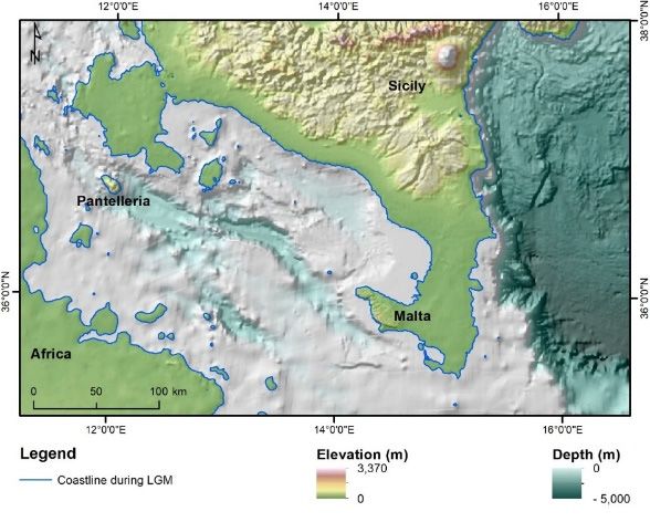
Water 2020, 12, 2221                                                                               6 of 35

     are differently categorized in: Rubin and McCulloch [156]; Ashley [157]; Wynn and Stow [158];
     Stow et al. [159]);
•    Standardized symbology: standard symbols are codified for terrestrial geomorphological
     mapping, though they may vary from country to country, while they are lacking
     for submarine geomorphological mapping and for integrated terrestrial and submarine
     geomorphological mapping;
•    Coverage of lithological and chronological information: in the terrestrial environment, the coverage
     of lithological and chronological data is generally much higher than for the seafloor, thanks to the
     wider availability of maps, DTMs, scientific literature, and datasets;
•    Acquiring elevation data in marine regions poses significant challenges and some limitations which
     make the process more complex, from a technological point of view, than in the emerged system.
     Customized surveys and dedicated technological solutions are indeed required to apply specific
     corrections that can address all measurements errors created in particular by hydrodynamics
     (especially tides and wave motion that must be always severely taken into account in hydrographic
     survey carried out by mean of echo-sounders) and the physical variability of the water column
     (which has a strong impact on the sound velocity/refraction of beams, creating at places challenging
     conditions, such as in the case of fresh water influx at the mouth of a river). Cloud coverage,
     turbidity, water surface glint and breaking waves can also create challenging environmental and
     operational condition that may prevail during optical remote sensing surveys in shallow water.

      Nevertheless, the scientific community has recently paid increasing attention to the
above-mentioned issues and different solutions were introduced to overcome them. First of
all, technological improvements in acoustic remote sensing has now made it possible to acquire
high-resolution elevation data in shallow environments, ranging from 0.5 m [160] to 0.05 m of
resolution [28,161], and also with precision and accuracy close to those achievable for terrestrial
landscape investigation. In addition, even the deep environment (deeper than 200 m, [162])
can be now surveyed at high resolution thanks to the progress made by underwater robotics.
Some compromises are still needed for shallow-water data acquisition, but recent progress has
definitely produced unprecedented results (see Section 3.2 and Table 2 for additional details). On the
contrary, the standardization of terminology, classification schemes, and symbology is definitely
still an unresolved issue, even though many efforts have been made globally to offer practical and
applicable solutions in different contexts. In December 2015, a partnership originated from seabed
mapping programs of Norway, Ireland and the UK (MAREANO, INFOMAR, and MAREMAP,
respectively—MIM) shares experiences, knowledge, expertise and technology in order to propose
advancement in best practices for geological seabed mapping [163]. The development of a standardized
geomorphological classification approach, following previous work published by the British Geological
Survey [164], has been one of the key activities of the MIM group. At the European level,
the EMODnet-Geology Portal (European Marine Observation and Data Network; [165]) is collecting
data from European state members on the geology and geomorphology of European seabeds and
harmonizing the geomorphological representation through a vocabulary developed by the Federal
Institute for Geosciences and Natural Resources [166] and by the British Geological Survey [167].
In addition to research strictly dealing with geological and geomorphological mapping, further
inputs have been also provided by organizations extensively involved in providing seafloor maps
for several environmental purposes, but where precise representation and definition of submarine
landforms were crucial for their applications. The Integrated Ocean and Coastal Mapping (IOCM) of
the National Oceanic and Atmospheric Administration (NOAA) developed the Coastal and Marine
Ecological Classification Standard (CMECS), a scheme for classifying benthic habitats that includes a
geomorphic level for the description of submarine landforms. At the European level (within the frame
of different EU funded projects, such as Mapping European Seabed Habitats (MESH), CoralFish [168]
and CoCoNet [169] among others), various classification schemes were proposed [170,171] taking
inspiration from the CMECS and/or from the analogue European classification scheme EUNIS [172].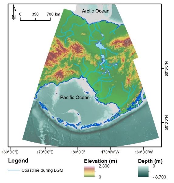
Water 2020, 12, 2221                                                                                                           7 of 35

      Table 2. List of sensors and techniques cited in the text which are relevant for collecting elevation data
      in the shallow-water environment (i.e., white ribbon). Active sensors are those sensors that control
      the projection of acoustic or electromagnetic waves (i.e., sound or light) onto the scene, while the
      term “passive” refers to those systems or techniques that use ambient light to illuminate the scene
      or techniques such as Structure from Motion (SfM). MBES: Multi-Beam Echo-Sounder; PDBS: Phase
      Differencing Bathymetric Systems; MPES: multi-phase echo-sounders; ASV: Autonomous Surface
      Vessels; USV: Uncrewed surface vehicles; ROV: Remotely Operated Vehicle; UAV: Uncrewed Aerial
      Vehicle; LiDAR: Light Detecting And Ranging; LLS: Laser Line Scanning; SDB: Satellite-Derived
      Bathymetry; SfM: Structure from Motion.

                                                            Active Sensors
                                                                         Achievable DTM Resolution
                            Sensor                    Platform                                            Survey Environment
                                                                                (Nearshore)
                    MBES (beamforming)
                                                  Vessel ASV/USV
                   PDBS (Interferometers)                                        Sub-metric                       Water
                                                        ROV
                      MPES (Hybrid)
                                                                         CONS:
                   PROS:                                                 -   Time consuming because of unfavorable ratio in
                   -     Accuracy and precision address                      coverage/unit of time (i.e., small areas covered in a
      Acoustic           international standards and can                     long period of time)
                         be validated                                    -   Sensor must be immerged for data acquisition;
                   -     Dedicated software support accurate data            very shallow depth measurements (roughly ≤ 2 m)
                         processing and standard requirements                cannot be performed
                                                                         -   Not suitable for very shallow and topographically
                                                                             complex seafloor
                       Bathymetric LiDAR           Airborne UAV                  Sub-metric                     Air/water
                   PROS:
                                                                         CONS:
                   -     Favorable ratio in coverage/unit of time
                                                                         -   Data processing is often time consuming
                         (i.e., wide areas covered in a relatively
                         small period of time)                           -   Environmental conditions can pose relevant
                                                                             constrains (water turbidity and
                   -     Accuracy and precision address
                                                                             atmospheric condition)
                         international standards and can
       Optical           be validated
                              LLS                    Vessel ROV                  Sub-metric                       Water
                   PROS:                                                 CONS:
                   -     Favorable ratio in coverage/unit of time        -   Data processing is often time consuming and
                   -     ROV-based LLS survey can provide                    results can be difficult to validate
                         high-resolution data in deep and complex        -   Environmental conditions can pose relevant
                         environments, which are difficult to cover          constrains (water turbidity in particular)
                         with traditional ROV-based MBES surveys
                                         Passive Sensors and Computational Techniques
                             Name                     Platform           DTM Resolution (Nearshore)       Survey Environment
                             SDB                       Satellite                     2m                         Air/Water
                                                                         CONS:
                   PROS:
                                                                         -   Accuracy and precision are dependent on
                   -     Highly favorable ratio in coverage/unit of
                                                                             processing algorithms (they do not rely on sensor
                         time (i.e., wide areas covered in a
                                                                             performance and are not part of
                         relatively small period of time)
                                                                             technical specification)
                   -     Source data are public and available
                                                                         -   Data processing is often time consuming
                         (i.e., Sentinel-2)
                                                                         -   Environmental conditions can pose relevant
                   -     Source data also offer photorealistic view
                                                                             constrains (water turbidity, cloud coverage)
                         of the surveyed scene
       Optical
                              SfM                       UAV                      Sub-metric                     Air/Water
                   PROS:                                                 CONS:
                   -     Favorable ratio in coverage/unit of time        -   Data processing is often time consuming
                         (i.e., wide areas covered in relatively small   -   There are no available standards and public
                         period of time)                                     protocols for data processing to guarantee accuracy
                   -     Camera and platforms (i.e., drones) are             of obtained elevation data
                         available also at low costs                     -   Need for ground control points (GCP) to
                   -     Source data also offer photorealistic view          validate results
                         of the surveyed scene                           -   Environmental conditions can pose relevant
                                                                             constrains (water turbidity, glint, breaking waves)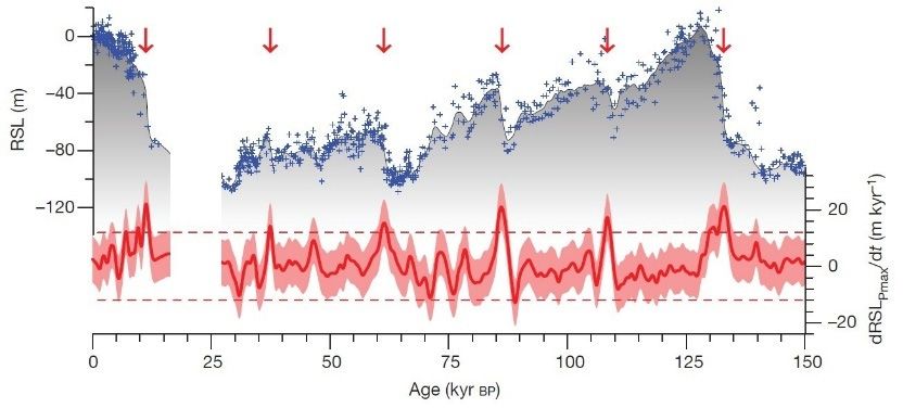
Water 2020, 12, 2221 8 of 35
Water 2020, 12,
x
A few attempts have recently been made to overcome the critical issue of defining a standard 9 of 36
symbology for submarine and integrated land–sea geomorphological mapping, and most of them
Table 2. Cont.
addressed the issue at the national level. Within the CARG Project (Italian official Geological
Cartography), the Institute forPassive the Protection
Sensors andand Environmental
Computational TechniquesResearch (ISPRA) promoted the
production Name Platform
of Geological and Geothematic DTM
Sheets at theResolution (Nearshore)
scale 1:50,000 Survey Environment
of the Italian territory. In particular,
SDB Satellite 2m Air/Water
in coastal areas, both terrestrial and marine geology and terrestrial and marine geomorphology were
PROS:
represented
- [173]. favorable
Highly Recently, theinWorking
ratio GroupCONS:
coverage/unit on Coastal Morphodynamics of the Italian Association
- Accuracy and precision are dependent on processing
of Physical
of timeGeography
(i.e., wide areasand Geomorphology—in
covered in a relatively agreement with ISPRA—revised and updated the
algorithms (they do not rely on sensor performance and are not
small period of time) Map of Italy” [27] with reference to coastal, marine, lagoon and
legend for the “Geomorphological part of technical specification)
- Source data are public and available
aeolian landforms, processes and deposits [23]. Within -the revision process
Data processing submerged
is often landforms and
time consuming
(i.e., Sentinel-2)
deposits-down to the continental - Environmental conditions can pose
shelf break were included in the new legend. The first applications relevant constrains of
Source data also offer photorealistic
(water turbidity, cloud coverage)
this new legend viewwere provided
of the by Brandolini et al. [25], Furlani et al. [26] and Prampolini et al. [6,24].
surveyed scene
Optical
Brandolini et al. [25] compared multi-temporal maps of anthropogenic landforms in Genoa city
(Liguria region, SfM Italy) to analyze UAVthe urban development Sub-metric
since the Middle Age to provide Air/Watera tool for
PROS:
geo-hydrological risk assessment. Furlani etCONS: al. [26] surveyed and mapped the coastal stretch of
- Favorable ratio in coverage/unit of time
the Conero system - Data processing is often time consuming
(i.e., wide areas(Marche
covered inregion,
relativelyItaly),
small focusing on tidal notches as geomorphological markers
- There are no available standards and public protocols for
for analyzing Late-Holocene period of time)tectonic stability of the area. Prampolini et al. [6,24] surveyed and
data processing to guarantee accuracy of obtained elevation data
mapped - coastalCamera andand platforms (i.e.,
submarine drones)
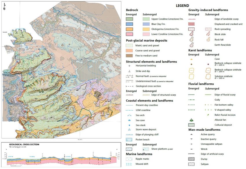
areas of theareMaltese archipelago in order to produce the first integrated
- Need for ground control points (GCP) to validate results
available also at low costs
geomorphological
-
maps of the islands,
Source data also offer photorealistic
constituting - the basis for geomorphological
Environmental reconstruction
conditions can pose relevant constrainsand
coastal hazardview assessment in an environment highly (waterto
sensitive turbidity,
ongoing glint, breaking
climate waves) (Figure 3).
change
of the surveyed scene
Figure 3.3.Sketch
Sketchofof
thethe “Integrated
“Integrated geomorphological
geomorphological map map of emerged
of emerged and submerged
and submerged areas of
areas of northern
northern
Malta andMalta
Comino and Comino
(central (central Mediterranean
Mediterranean Sea)”scale
Sea)” at 1:25,000 at 1:25,000 scale
and related and (modified
legend related legend
after
(modified after Prampolini
Prampolini et al. [6]). et al. [6]).
With reference Changes
2.2. Late-Quaternary to the coverage
of CoastalofLandscapes
lithological and chronological information, it is possible to
produce marine geological maps exploiting data coming from marine geological and geophysical
Scientific literature referring to integrated analyses of terrestrial and marine geospatial datasets
surveys. Examples from the Italian coastal and marine areas are given by ISPRA and Gasparo
related to coastal areas and continental shelves has proved to be critical in outlining Late-Quaternary
Morticelli et al. [22]. ISPRA, thanks to the CARG Project, has promoted the mapping of the marine
coastal changes and paleo-landscapes.
geology of the Adriatic Sea, scale 1:250,000 [174], to represent the main geological structures of the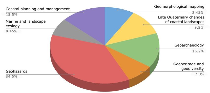
Water 2020, 12, 2221                                                                                          9 of 35

                 Adriatic continental shelf. Gasparo Morticelli et al. [22] published the geological map of Marettimo
                 Island and the submerged surroundings (Egadi Islands, central Mediterranean Sea), scale 1:10,000,
                 integrating data from field surveys and previous marine geological and geophysical surveys, carried out
                 within the CARG Project. Moreover, advances are being made in correlating seabed acoustic backscatter
                 with surface sediments to perform automatic ground discrimination and reduce the number of ground
                 truth stations required to produce robust seabed characterization. Recent availability of well-data from
                 the industry (e.g., ViDEPi [175]) and progress in seismic analysis and seismo-stratigraphic correlation,
                 contributed for a wider geological characterization of the subseafloor too. This way, it is possible to get
                 a wider coverage of lithological and chronological information for submarine regions.
Water                                                               2020,                                                                12,
x                2.2. Late-Quaternary Changes of Coastal Landscapes
                 Scientific literature referring to integrated analyses of terrestrial and marine geospatial datasets       10 of 36
            related to coastal areas and continental shelves has proved to be critical in outlining Late-Quaternary
            coastal global
     Quaternary     changes sea-level
                              and paleo-landscapes.
                                           changes have been largely studied worldwide with special attention
                 Quaternary global sea-level changes have been largely studied worldwide with special attention
to the late Pleistocene      and Last
            to the late Pleistocene        Glacial
                                       and Last       Maximum
                                                Glacial              (LGM),
                                                         Maximum (LGM),      whenwhen     the relative
                                                                                    the relative sea levelsea  level
                                                                                                           reached its reached its
minimum height
            minimum of height
                        ca. 120–130       m below
                                of ca. 120–130 m belowthethepresent   sealevel
                                                             present sea   level   (Figure
                                                                               (Figure       4) [176,177].
                                                                                       4) [176,177].

                       Figure 4. Sea-level changes during the Quaternary (modified after Grant et al. [177]). Relative sea-level
        Figure 4. Sea-level    changes during the Quaternary (modified after Grant et al. [177]). Relative sea-
                    (RSL) data (blue crosses) and maximum probability of RSL (grey shading) for the last 150 kyr, with an
        level (RSL) indication
                    data (blue     crosses)
                               of the          and maximum
                                      rates of sea-level           probability
                                                         changes (dRSL             of RSL
                                                                      Pmax /dt) expressed as (grey
                                                                                             m/kyr. shading) for the last 150 kyr,
        with an indication of the rates of sea-level changes (dRSLPmax/dt) expressed as m/kyr.
                 Consequently, most of the present marine areas down to 130 m of depth, including large portions
            of the world continental shelves, were emerged during the LGM and modelled by subaerial processes:
     Consequently,       most ofofthe
            the paleo-geography             present
                                       emerged         marine areas
                                                 and submerged     areaswasdown       to 130from
                                                                              very different     m today,
                                                                                                      of depth,     including large
                                                                                                            and included
portions of the
            land world     continental
                 bridges between            shelves,
                                   continental         were
                                                landmasses     emerged
                                                             which          during
                                                                    do not exist       the(e.g.,
                                                                                 anymore    LGM       andbridge
                                                                                                 the land   modelled
                                                                                                                 betweenby subaerial
            Sicily and the Maltese Archipelago—Figure 5—or between Sicily and Egadi Islands of Favignana
processes: the paleo-geography of emerged and submerged areas was very different from today, and
            and Levanzo, in southern Europe [39,42], or the Bering land bridge in the northern Pacific Ocean
included land    bridges
            (Figure          between continental landmasses which do not exist anymore (e.g., the land
                     6) [178]).
bridge betweenThe  Sicily   and the
                      post-glacial      Maltese
                                   sea-level       Archipelago—Figure
                                             rise covered                         5—or
                                                           these landscapes, either        between
                                                                                     drowning     [33,37]Sicily  and Egadi Islands
                                                                                                          or re-modelling
of Favignanathemandthrough   marine in
                       Levanzo,      processes.
                                         southern At some  places,[39,42],
                                                      Europe        the previously
                                                                             or theemerged
                                                                                       Bering  areas
                                                                                                   landhosted  prehistoric
                                                                                                           bridge   in the northern
            and historic human settlements—as demonstrated by ruins, pollens, bones, or other remains in
Pacific Ocean   (Figure 6) [178]).
            the sediments, caves, etc. (cf. Section 2.3) [56]. The post-glacial marine transgression led to the
     The post-glacial
            disappearance sea-level    riseland
                             of vast areas,  covered
                                                 bridges,these
                                                          human landscapes,       either
                                                                   settlements, and        drowningof[33,37]
                                                                                     a reconfiguration              or re-modelling
                                                                                                             geographical
            boundaries.    Indeed,  the reconstruction  of paleo-landscapes    and  their geomorphological
them through marine processes. At some places, the previously emerged areas hosted prehistoric and              evolution
            is the basis for further investigations (e.g., on geohazard assessment, identification, and study of
historic human      settlements—as demonstrated by ruins, pollens, bones, or other remains in the
            geoarchaeological sites).
sediments, caves, etc. (cf. Section 2.3) [56]. The post-glacial marine transgression led to the
disappearance of vast areas, land bridges, human settlements, and a reconfiguration of geographical
boundaries. Indeed, the reconstruction of paleo-landscapes and their geomorphological evolution is
the basis for further investigations (e.g., on geohazard assessment, identification, and study of
geoarchaeological sites).
Water 2020, 12,
Water
x 2020, 12,
Water
x 2020, 12, 2221 10
11 of
of 35
36
11 of 36
Figure 5. The land bridge between Sicily and Malta (Central Mediterranean Sea) during the LGM
Figure 5. The land bridge between Sicily and Malta (Central Mediterranean Sea) during the LGM
Figure 5. The
(modified afterland bridge between
Prampolini et al. [6]).Sicily and Malta (Central Mediterranean Sea) during the LGM
(modified after Prampolini et al. [6]).
(modified after Prampolini et al. [6]).
Figure
Figure 6. The Bering
6. The Bering land
land bridge
bridge during
during the
the LGM
LGM (modified
(modified after
after Bond
Bond [179]).
[179]).
Figure 6. The Bering land bridge during the LGM (modified after Bond [179]).
To reconstruct ancient landscapes located in coastal and shallow-water environments,
Numerous examples of terrestrial and marine data integration for the reconstruction of paleo-
geomorphological,
Numerous archaeological,
examples and and
of terrestrial geophysical
marine observations of both terrestrial and submarine
landscapes are from the Mediterranean Basin [38].data
Lo integration
Presti et al.for[42] the reconstruction
reconstructed of paleo-
the paleo-
areas are
landscapes required,
areEgadi together
fromIslands with absolute
the Mediterranean dating
Basin [38]. of terrestrial
Lo Presti and marine
et the
al. [42] sediments, remains and
geography of and relative sea-level variations from LGMreconstructed the paleo-
until today. Furlani and
landforms
geography [54,61].
of Egadi Hence,
Islandstechnological
and relative advances
sea-level in acquiring
variations data
from in
the nearshore
LGM areas
until and
today. in merging
Furlani and
Martin [40] reconstructed the paleo-geography of Faraglioni coast (Ustica Island) that was settlement
terrestrial
Martin [40]and marine spatial
reconstructed the datasets (e.g., elevation
paleo-geography data) are
of Faraglioni fundamental
coast (Ustica for the
Island) reconstruction
that was of
of a Middle Bronze Age village. They combined geomorphological observation made insettlement
nearshore
present
of emerged
a Middle and submerged topography and to infer paleo-geography.
and onshoreBronzeareas.Age village.etThey
Miccadei al. combined geomorphological
[18,19] reconstructed observation made
the Late-Quaternary in nearshore
landscape and
and Numerous
onshore examples
areas. Miccadei of terrestrial
et al. and marine
[18,19] data integration
reconstructed the for the reconstruction
Late-Quaternary landscape of
and
geomorphological evolution of Tremiti Islands, located north of Gargano promontory, southern
paleo-landscapes
geomorphological are from
evolution the Mediterranean
ofcarried
Tremitiout Islands, Basin [38]. Lo
located northstudy Presti et
of Gargano al. [42] reconstructed
promontory, the
southern
Adriatic Sea. Aucelli et al. [36] a multidisciplinary of submerged ruins of Roman
paleo-geography
Adriatic Sea. of Egadi
Aucelli et al.Islands
[36] and relative
carried out a sea-level variations
multidisciplinary fromofthe
study LGM untilruins
submerged today.of Furlani
Roman
buildings on the Sorrento Peninsula coast (Gulf of Naples). These archaeological remains enabled the
and Martin
buildings on [40] reconstructed
theofSorrento Peninsulathe coast
paleo-geography of Faraglioni coast (Ustica Island) that was
reconstruction the ancient position of(Gulf
bothofthe Naples). These
sea level andarchaeological
the coastline. remains
Rovereenabled the
et al. [31]
settlement
reconstructionof a Middle Bronze
of the ancient Age village.
position of of They
both combined geomorphological observation made in
analyzed the submarine geomorphology thethe sea level
offshore and the
between coastline.
Finale Ligure Rovere
and Vado et al. [31]
Ligure
nearshore
analyzed and onshore areas. Miccadei et al. [18,19] reconstructed the Late-Quaternary landscape
(western the submarine
Liguria, geomorphologySea)
NW Mediterranean of the
for offshore
the firstbetween Finale Ligure
time, detecting and Vado
meaningful Ligure
submarine
and geomorphological
(western Liguria, NW evolution
Mediterraneanof Tremiti
Sea) Islands,
for located
the first north of
time, Garganomeaningful
detecting promontory,submarine
southern
geomorphological indicators of former sea levels. Micallef et al. [33] and Foglini et al. [37]
Adriatic Sea. Aucelli
geomorphological et al. [36] of
indicators carried
formeroutseaa multidisciplinary
levels. Micallef study et al.of[33]
submerged ruinset
and Foglini of al.
Roman
[37]Water 2020, 12, 2221 11 of 35
buildings on the Sorrento Peninsula coast (Gulf of Naples). These archaeological remains enabled the
reconstruction of the ancient position of both the sea level and the coastline. Rovere et al. [31] analyzed
the submarine geomorphology of the offshore between Finale Ligure and Vado Ligure (western
Liguria, NW Mediterranean Sea) for the first time, detecting meaningful submarine geomorphological
indicators of former sea levels. Micallef et al. [33] and Foglini et al. [37] reconstructed Late-Quaternary
coastal landscape morphology and evolution of the Maltese archipelago, while Furlani et al. [39]
focused their research on marine notches of the Maltese Islands that resulted in confirmation of the
slowdown of the Late-Holocene marine transgression.
Examples from northern Europe come, among the others, from southern England and northern
France [29], and from Northern Ireland [32]. Bridgland et al. [29] analyzed three fluvial sequences,
particularly terrace staircases, from southern England and northern France to reconstruct climate
fluctuations and paleo-geography of those areas. Westley et al. [32] mapped the continental shelf of
northern coast of Ireland and examined the geomorphology for evidence of past sea-level changes,
reconstructed the paleo-geography of the area considering sea-level lowstands of −30, −14 and −6 m.
This research allowed the identification of ten areas of high archaeological potential.
The combined mapping of emerged and submerged geomorphological features proved to be
functional in analyzing the long-term evolution of coastal landslides. Prampolini et al. [6] showed
that coastal block slides along the NW coast of Malta prolong below the sea level, reaching a depth of
about 40 m, and Soldati et al. [180] demonstrated by means of cosmogenic nuclide dating that they
developed in a subaerial environment—when the coastline was much lower than today—having been
submerged only later on, during the post-glacial sea-level rise.
2.3. Geoarchaeology
As earlier mentioned, Late-Quaternary sea-level changes have exposed large portion of the
present-day continental shelves for long periods of time, resulting in a multitude of archaeological
remains lying on the seafloor today [4,45,46,48,49,52]. Therefore, coupling terrestrial and marine
datasets can be critical in detecting new archaeological sites in coastal and nearshore areas and for a
more comprehensive understanding of already existing ones [60] and references therein. Analyzing
coastal archaeological sites can also contribute to the reconstruction of the paleo-geography of ancient
landscapes [48], and in particular to infer Late-Holocene relative sea-level oscillations (e.g., [43,51]).
Some archaeological remains include functional structures or elements that are unequivocally related
to specific elevation of past sea levels, because of their architecture and proximity to the sea. In other
cases, an in-depth knowledge of landscape evolution helps inferring about the evolution or the dating
of archaeological remains. For example, the proximity of an archaeological site with coastal landforms,
whose evolution can be reconstructed, will help in dating and reconstructing the history of the site
itself [40] and references therein.
As a matter of fact, early human populations tended to move and expand occupying new
territories, in particular during the last glaciation and the early post-glacial period—a period of
time characterized by extreme climate fluctuations [56]. In this frame, the most attractive sites
for human settlements were coastal lowlands that in some parts of the world, were much more
extended than today thanks to sea-level lowstands (e.g., during the LGM, the European land
area was 40% wider than presently; [56,181]). During that period, coastal regions were the most
densely populated since they profited from more tempered climates that led to enhanced water
supplies, and greater ecological diversity. Hence, these areas were sites of prehistoric and historic
human settlements, as witnessed by the findings of archaeological remains, pollens, bones, or other
ruins in the sediments, caves etc. Then post-glacial sea-level rise led to the flooding of these
former territories, redrawing geographical boundaries, and human, plant and animal distributions
(cf. Section 2.2) [56,181]. In this context, Harff et al. [56] reported the results achieved within the
framework of the SPLASHCOS Project—Submerged Prehistoric Archaeology and Landscapes of the
Continental Shelf—(Cooperation in Science and Technology—COST Action TD0902). They succeededWater 2020, 12, 2221 12 of 35
in gathering together experts in geology, archaeology, and climate interested in sea-level changes,
paleo-climatology and paleo-geography for reconstructing European submerged landscapes in order
to assess their archaeological potential (e.g., [37], cf. Section 2.2).
Geoarchaeological research benefiting from the integration of terrestrial and marine datasets
is illustrated with reference to the Mediterranean area by Furlani et al. [50], Aucelli et al. [36,55],
Furlani and Martin [40] and Mattei et al. [59]. Furlani et al. [50] studied submerged or partially
submerged archaeological structures located along the Maltese coasts providing a first attempt for
paleo-environmental reconstruction of the Maltese archipelago from the LGM until today, allowing time
and mode of mammal dispersal to the island during the Pleistocene to be inferred. Aucelli et al. [36]
analyzed submerged ruins of Roman buildings located along the Sorrento Peninsula coast (Italy)
and succeeded in reconstructing sea-level oscillations and coastline changes for the Late-Holocene
and tectonic history of the Sorrento Peninsula during the last two millennia. Aucelli et al. [55]
explored and mapped the main underwater structures on and below the seabed of the Roman Villa
of Marina di Equa (Sorrento Peninsula) and analyzed the geological effects of the 79 A.D. eruption
of Vesuvius with the aim of reconstructing the interactions between human and natural events.
Furlani and Martin [40] reconstructed the paleo-geography of Ustica Island, focusing on Faraglioni
Village, providing clues on the evolution of one of the best-preserved Middle Bronze Age sites in the
Mediterranean. Mattei et al. [59] reconstructed the natural and anthropogenic underwater landscape
of the submerged Roman harbor of Nisida Island (Gulf of Naples, Italy), the relative sea-level variation
in the last 2000 years and outlined the coastal geomorphological evolution of the area.
In northern Europe, Westley et al. [53] exploited the data acquired and analyzed by Westley et al. [32]
(cf. Section 2.2) to reconstruct Early–Mid-Holocene paleo-geography of the Ramore Head area (Northern
Ireland), hosting evidence of Mesolithic occupation and preserved Early–Mid-Holocene peats both on-
and offshore.
Examples of integration of land–sea datasets for geoarchaeological purposes outside the
Mediterranean area are provided by Fisher et al. [47] and Cawthra et al. [57] for South Africa,
by Bailey et al. [54] for Saudi Arabia, and by Benjamin et al. [58] and Veth et al. [61] for Western
Australia. Fisher et al. [47] developed a conceptual tool that enable correlation of the evolution of
human behavior within a dynamic model of changes of paleo-environment. Cawthra et al. [57]
analyzed paleo-coastal environments, laying on the present continental shelf, offshore of the Pinnacle
Point archaeological locality (Mossel Bay, South Africa). During the Pleistocene, these environments
were probably settlement of early-modern humans. Bailey et al. [54] analyzed emerged and submerged
landscape of SW Saudi Arabia to study human dispersal in Late Pleistocene and Early Holocene. Finally,
Benjamin et al. [58] and Veth et al. [61] analyzed a large amount of data (airborne LiDAR, underwater
acoustics, cores and scuba dives observations) acquired in Western Australia for archaeological research.
Coupling land–sea data is now more feasible thanks to modern marine research technologies,
integration of large databases and proxy data [60] and references therein, allowing further hidden
archaeological sites to be discovered and studied in the near future. Recently, this has proved to be
successful is the case of the ancient Roman city of Baia located inside the Bay of Pozzuoli and belonging
to the Campi Flegrei Archeological Park (Southern Italy). The site is superbly preserved underwater
after having been slowly drowned due to bradyseismic movements which characterize this area near
the Vesuvius volcano [182].
Geoarchaeological investigations, particularly in coastal and submerged environments are
increasing and are taking advantage of new contributions and new approaches in surveying and
collecting data using a combination of acoustic and optical remote sensing sources, to recreate a full
picture of the present and old landscapes, validated through field surveys observations and absolute
dating evidence (e.g., Uncrewed Surface Vehicle simultaneously acquiring geophysical data and images
for photogrammetry and drones equipped with cameras).Water 2020, 12, 2221 13 of 35
2.4. Geoheritage and Geodiversity
Integrating terrestrial and marine datasets can be of paramount importance for the assessment of
terrestrial and marine sites of geological interest in coastal and shallow-water areas. Both the shore
and inner continental shelf show common processes and landforms that should be considered to be a
single feature (cf. Sections 2.1 and 2.2) [66].
Geosites—or geodiversity sites (sensu Brilha [183])—are places of a certain value due to human
perception or exploitation and include geological elements with high scientific, educational, aesthetic,
and cultural importance [71]. Geosites and key geodiversity areas are often protected areas thanks to
different directives (e.g., EU Habitat Directive, 1992; OSPAR Convention, 1992; EU Marine Strategy
Framework Directive, 2008). Indeed, the importance of preserving geodiversity has been acknowledged
mainly thanks to the effect that geodiversity has on biodiversity patterns [184]. Hence, the assessment of
geosites and key geodiversity areas enhance the identification of areas that need protection (e.g., Marine
Protected Areas—MPAs—Geoparks; cf. Sections 2.6 and 2.7).
Geoheritage and geodiversity have been investigated mainly in terrestrial environments [71]
and references therein, while only a few studies on this topic refer to underwater environments
(cf. [62–64,66]). With reference to the latter, Orrù and Ulzega [62], Orrù et al. [63,64] identified
underwater trails for scuba divers in the MPAs of Capo Carbonara and of Capo Caccia (Sardinia, Italy)
enhancing the value of the whole underwater environment. Rovere et al. [66] assessed underwater
geomorphological heritage in the Bergeggi MPA (Ligurian Sea, Italy) and in the Sigri area (Lesvos
Island, Greece); however they considered that a complete approach in studies on geoheritage would
take both emerged and submerged landforms of the coastal and nearshore environments into account.
Very few studies deal with the integrated assessment of terrestrial and marine sites of
geological interest. This is largely due to technological constraints and, to some extent,
to conceptual issues—such as (i) differences in attributes related to geosites in terrestrial and marine
environments [185]; (ii) different perception and fruition of abiotic features of the aquatic environment
by tourists; and (iii) lack of common schemes and approaches to the identification, assessment,
and improvement of submarine geosites. However, attention to these themes is increasing presently.
Coratza et al. [71] identified and assessed the terrestrial and marine geosites of the Portofino
Natural Park and MPA (Liguria, Italy), which are internationally known for both terrestrial scenic
landforms and quality of the marine ecosystem. They aimed at identifying the most suitable
sites for tourist improvement and defining possible connections between terrestrial and marine
environments. Finally, they were able to identify a significant number of both terrestrial and marine
sites, assessing their scientific value, ecological, cultural, and aesthetic importance, and accessibility,
services, and economic potential.
The identification and quantitative assessment of geodiversity in terrestrial areas are already
established and several countries have been developing national inventories of geodiversity key
areas by means of different methods [183]. Only recently, this discipline has been addressed to the
marine environment and its elements of geodiversity. Examples of geodiversity assessment in marine
areas come from Scotland [65–70], southeast Brazil [67], Hawaiian and Canarian Islands and the New
Zealand subduction zone [68]. Brooks et al. [65] and Gordon et al. [69,70] focused on the contribution of
geo-conservation within the Marine Protected Area network for Scottish seawaters. Their work is the
first systematic assessment of marine geodiversity key areas comparable to the Geological Conservation
Review geo-conservation carried out for the terrestrial geology and geomorphology of Great Britain,
which was “a world-first project of its type in the systematic assessment of the whole geological
heritage of a country, from first principles” [69]. Mansini Maia and Alencar Castro [67] developed
a model for characterizing marine geodiversity at a regional scale in the Vitória–Trindade Volcanic
Seamount Ridge and its surroundings (SE Brazil). They aimed at supporting Brazilian marine spatial
planning regarding geo-conservation of features related to the geological history of Brazil and the most
vulnerable habitats. Finally, Veloo [68] developed a geodiversity index for the seafloor and applied itYou can also read