Development of a regional groundwater monitoring network - Theoretical considerations and case study for a project area in the Upper Kafue ...
←
→
Page content transcription
If your browser does not render page correctly, please read the page content below
Development of
 a regional
 groundwater
 monitoring network
 Theoretical considerations and
case study for a project area in the
 Upper Kafue Sub-catchment

 Technical Report No. 1
 Hannover/Ndola, October 2018
Authors: Roland Bäumle (BGR) & Marcus Fahle (BGR/GReSP)
Commissioned by: Federal Ministry for Economic Cooperation and Development
 (Bundesministerium für wirtschaftliche Zusammenarbeit und
 Entwicklung, BMZ)
Project: Groundwater Management in Zambia with Focus on the
 Upper Kafue Catchment
BMZ-No.: 2014.2073.6
BGR-No.: 05-2386

Date: June 20, 2019
 -II-
SUMM ARY

Authors: Roland Bäumle (BGR), Marcus Fahle (BGR/GReSP)

Title: Development of a regional groundwater monitoring network
 Theoretical considerations and case study for a project area in the Upper Kafue
 Sub-catchment

Keywords: Groundwater monitoring, Monitoring network design, Zambia, Upper Kafue

Abstract
Groundwater monitoring is the key prerequisite for groundwater management as sound
decisions can only be made if sufficient and adequate data is available. Various aspects have
to be taken into account when setting up a groundwater monitoring network for the first time.
The objectives of the monitoring and the responsibilities have to be defined before the
network can be designed. The design then has to specify which parameters are going to be
monitored, where what kind of monitoring is needed and at which frequency observations
have to be made.
The first part of this report outlines the theoretical considerations of designing groundwater
monitoring networks based on a comprehensive review of existing manuals, reports and
articles, published either by international organisations or in scientific journals.
The second part of the report applies these considerations to a study area of the Groundwater
Resources Management Support Programme (GReSP) project in the Upper Kafue Sub-
catchment, Zambia. After giving a background on groundwater monitoring responsibilities
according to the Water Resources Management Act of 2011 and on the history of hydrometric
monitoring in Zambia, the general hydrological and hydrogeological characteristics of the
study area are outlined. The theoretical framework is then applied to design an initial network,
intended to give a reference data set to enable a detailed description of the area’s
hydrogeological conditions. Finally, first observations of the installed network are used to
evaluate the decisions taken in the design process and conclusions on further steps ahead in
the monitoring of the respective area are given.

 -III-
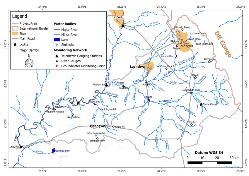
Table of contents
Summary III
List of reports compiled by the project in phase IV IX
Executive summary X
Introduction 1
Part A: Development of a regional groundwater monitoring network - A literature review 3
1. Definitions 3
2. Monitoring objectives 3
 2.1. Objectives related to the general status of groundwater and trends 3
 2.2. Objectives related to improved management and support for hydrogeological science 4
 2.3. Objectives related to protection of groundwater systems and the environment 4
3. Network types 5
 3.1. Network types with respect to its size 5
 3.2. Network types with respect to its development stage 5
 3.3. Network types with respect to parameters observed 5
 3.4. Network types with respect to its functions 5
4. Responsibilities 6
5. Network design 8
 5.1. General considerations in developing a groundwater monitoring program 8
 5.2. Comparison of groundwater with climate/meteorological monitoring 10
 5.3. Relevance of surface water monitoring for groundwater monitoring (and vice versa) 11
 5.4. Groundwater monitoring design components 12
 5.4.1. Network scale 13
 5.4.2. Parameters 13
 5.4.3. Types, location and distribution of observation points 17
 5.4.4. Number and density of observation sites 19
 5.4.5. Observation frequency 22
6. Conclusions 26
PART B: Proposed monitoring network for the GReSP study area in the Upper Kafue Sub-
catchment, Zambia 27
7. Background 27
 7.1. Legal regulations defining responsibilities of hydro(geo)logical monitoring in zambia 27
 7.2. Current state of water resources monitoring in zambia 28
 7.3. GReSP project 28
8. Site description and primary hydrogeological framework 29
 8.1. Geographical and geological overview 29
 8.2. Climate 30
 8.3. Socio-economic situation 31
 8.4. Hydrology and water resources management 32
 8.5. Hydrogeological setting 33
9. Type and objectives of monitoring network 35
10.Network design 36
 10.1. Network scale 36
 10.2. Parameters 37
 10.3. Locations of observation points 38
 10.3.1. General considerations 38
 -IV-

10.3.2. Positioning of river gauging stations 38
 10.3.3. Positioning of Groundwater Monitoring Stations 40
 10.3.4. Density of Observation Points 44
 10.4. Measurement Frequency 45
11.Preliminary evaluation of installed monitoring network 46
 11.1. Status of the installed network and measurements conducted 46
 11.2. Evaluation of the river gauging stations 47
 11.3. Evaluation of the groundwater monitoring stations 50
12.Outlook 53
13.References 56
Appendices i
A.1 Climate monitoring principles i
A.2 Water monitoring responsibilities in Zambia as prescribed by the Water Resources
Management Act of 2011 ii
A.3 Hydrological map of the study areA iv
A.4 Geological Map of the Study Area vi
A.5 Monitoring Network Development overview for the case study viii
A.6 Scheme of groundwater monitoring network development xii

 -V-
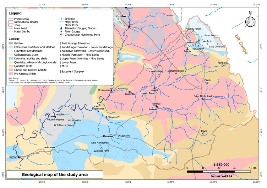
List of figures

Figure 1: Relationship between spatial scale and type of aquifer, critical response time and
 relative administrative scale (from Moench et al. (2014), p. 29). ...................................... 7
Figure 2: Development of a monitoring plan according to Johnston (2007). .................................. 9
Figure 3: Probability design for spatial monitoring (from ACWI (2013), p 27)............................... 17
Figure 4: Study area with elevations (SRTM 2000). ....................................................................... 30
Figure 5: Climatic data of the weather station in Ndola (WMO Station Number: 67561).
 Reference period 1961 to 1988 for temperature and 1961 to 1991 for precipitation. Data
 were extracted from National Oceanic and Atmospheric Administration’s ftp
 server(NOAA 2018). .......................................................................................................... 30
Figure 6: Districts within and surrounding the project area. ......................................................... 31
Figure 7: Hydrogeology of the study area (extracted from Hydrogeological Map of Zambia
 (Bäumle et al. 2018)). Classification of groundwater development prospect according to
 Struckmeyer & Margat (1995). ......................................................................................... 34
Figure 8: Geology of the study area (modified, after Thieme et al. (1981))and target areas for
 groundwater monitoring................................................................................................... 41
Figure 9: Installed monitoring network of the study area. ............................................................ 43
Figure 10: Water level of the Kafulafuta River in Ibenga. Note that in November 2016 water level
 fell below logger installation depth and, hence, could not be recorded. ......................... 47
Figure 11: Example of a preliminary rating curve established for the study area. Graph shows
 results for the Kafubu monitoring station in Ndola/Twapia. ............................................ 47
Figure 12: Comparison of hydrographs from logger data and gauge reader data (assuming perfect
 readings) at the Kafubu monitoring station in Ndola/Twapia. ......................................... 49
Figure 13: Examples of groundwater level measurements at handpumps: Low yielding borehole
 in Kasamba (left) vs. high yielding borehole in Titibuke (right). ....................................... 50
Figure 14: Way forward concerning monitoring in the project area. ............................................ 54

List of tables

Table 1: Division of responsibilities for groundwater monitoring (modified after IGRAC (2008) and
 Kresic (2009)) ...................................................................................................................... 8
Table 2: Main factors determining the network design (after Chilton & Foster (1996)) ............... 12
Table 3: Common groundwater pollution sources and the associated indicators or contaminants
 of concern (after Chilton & Foster (1996), UN/ECE (2000), EC (2003) & Kresic (2009)) ... 15
Table 4: Criteria for the positioning of groundwater observation points for different network
 types and monitoring objectives (after LAWA (1999a), supplemented) .......................... 18
Table 5: Examples of network densities from the U.S., Australia, Europe and SADC countries .... 21
Table 6: Matrix of sampling frequencies for water quality and quantitative networks, proposed
 by ACWI (2013) ................................................................................................................. 24
 -VI-
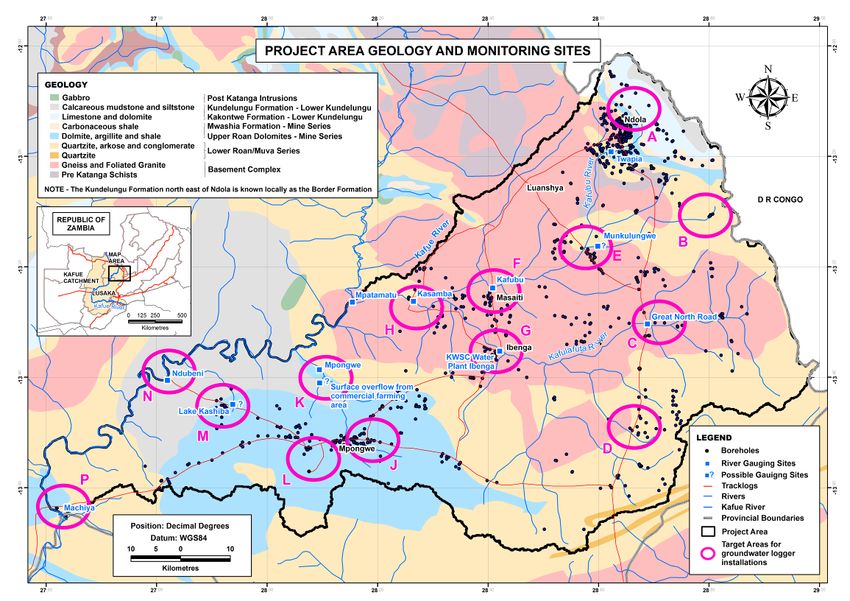
Table 7: Matrix of sampling frequencies for water quality networks, proposed by BGS (as quoted
 in IGRAC (2008) and EC (2003))......................................................................................... 24
Table 8: Matrix of sampling frequencies for water quality networks in relation to aquifer
 properties (top) and different scenarios (bottom), recommended in Germany (as quoted
 in EC (2003)) ...................................................................................................................... 25
Table 9: Area and population figures of the districts that are partly covered by the study area
 (Central Statistical Office 2014). ....................................................................................... 31
Table 10: Selected groundwater monitoring stations. Coordinates refer to WGS84. ................... 43

 -VII-
Abbreviations

BGR Bundesanstalt für Geowissenschaften und Rohstoffe (Federal Institute for
 Geosciences and Natural Resources)
ACWI Advisory Committee on Water Information
EC European Commission
eC Electrical conductivity
EEA European Environmental Agency
GGMN Global Groundwater Monitoring Network
GOS Global Observing System
GTN-H Global Terrestrial Network Hydrology
IGRAC International Groundwater Resources Assessment Centre
ISO International Organization for Standardization
LAWA Länderarbeitsgemeinschaft Wasser (German Federal States' Working
 Group on Water)
LHPC Lunsemfwa Hydro Power Company
NGWMN National ground-water monitoring network
SADC South African Development Community
SASSCAL Southern African Science Service Centre for Climate Change and Adaptive
 Land Management
UBA Umwelbundesamt (Germany‘s Environmental Protection Agency)
UN United Nations
UN/ECE United Nations Economic Commission for Europe
URL Uniform Resource Locator
WHO World Health Organization
WMO World Meteorological Organization
WRMA Water Resources Management Act
ZABS Zambian Bureau of Standards
ZESCO Zambia Electricity Supply Company
ZMD Zambian Meteorological Department
ZRA Zambezi River Authority

 -VIII-
LIST OF REPORTS COMPILED BY THE PROJECT IN
PHASE IV

Date Authors Title Type
October 2018 Roland Bäumle, Development of a regional groundwater Technical Report 01
 Marcus Fahle monitoring network
 - Theoretical considerations and case
 study for the project area in the Upper
 Kafue catchment -

March 2017 Torsten Krekeler Field Guide Technical Note 01
 - Second revised edition –

July 2017 Marcus Fahle, Specifications of the Monitoring Technical Note 02
 Max Karen, Network Installed in the Mpongwe Karst
 Tobias El-Fahem, Area and the Kafubu and Kafulafuta
 Torsten Krekeler, Catchments
 Mumba Kolala

 -IX-
EXECUTIVE SUMM ARY
Availability of accurate data on groundwater quantity and quality is the basis for sound
management of groundwater resources. In order to gather these data, groundwater monitoring
networks have to be set-up. First efforts in this respect, date back to the mid of the 19th century in
England and Wales, yet systematic nationwide groundwater monitoring was not introduced until
the period between 1950 and 1980. Only after 1980 systematic groundwater quality monitoring
came into place. Yet in many developing countries such coordinated efforts are still absent.
The process of developing groundwater monitoring networks involves a variability of steps from
gathering available information and developing a conceptual groundwater model of the area
under investigation, defining objectives and type of the network, designing the network,
implementing the design, set-up a monitoring plan, gathering and storing the recorded data. Once
a suitable amount of measurements has been recorded, e.g. data of several hydrological years,
these records can be analysed to evaluate and optimize the existing monitoring network. Hence,
the process of developing a monitoring network is iterative. The entire process is presented in a
scheme in Appendix A.6.
This report is separated into two parts. The first part gives theoretical considerations about the
development of groundwater monitoring networks. The focus lies on the design of the network,
the definition of monitoring objectives and network type as well as determining the
responsibilities for the monitoring. The remaining of the aforementioned points like the
development of a conceptual model or the set-up of a monitoring plan are not discussed in detail.
Still, they are also discussed in the second part, which describes the development of a groundwater
monitoring network for a study area in the Upper Kafue Sub-catchment, Zambia. This part also
includes a preliminary evaluation based on already gathered data, leading to recommendations
for the optimization of that network.
The theoretical part of the report first reviews definitions of monitoring. Then, the possible
monitoring objectives are summarised. While, to Kresic (2009) the general objective is “to describe
groundwater characteristics in space and time”, objectives can be grouped into three categories:
Objectives related to the general status of groundwater and trends, objectives related to improved
management and support for hydrogeological science and objectives related to protection of
groundwater systems and the environment. Every group encompasses several sub-objectives. Also
based on the objectives to be served, the monitoring network type has to be chosen.
Differentiations can be made according to the size, development stage, parameters observed and
the functions served by the network. The network type is one factor determining how is
responsible for the monitoring, among the aquifer type, administrative scale and the water
legislation in force.
The monitoring network has to not only consider objectives and arising information needs,
network type and responsibilities, but also the logistical and financial constraints as well as the
hydrogeological framework. The latter summarizes all information about aquifers, groundwater
flow, location of recharge and discharge areas as well as water users, hydrochemistry and places
of contamination or potential threats. Furthermore, the design has to be coordinated with surface
water monitoring efforts, as, for instance, streamflow data allow to set up water balances or to
derive baseflows, which serve as indicator for groundwater status and recharge.
The design of the network involves a variety of components. The network scale has to be defined,
i.e. which area should be encompassed by the network. Parameters to be monitored have to be
specified, both parameters describing quantitative (e.g. water levels, discharge) or qualitative
aspects (e.g. chemical and biological parameters). One of the most crucial parts of the design is
to determine the type (e.g. boreholes, handpumps, springs, lakes) and distribution of the
observation points. Different strategies for the distribution exist. In general, the different factors
 -X-
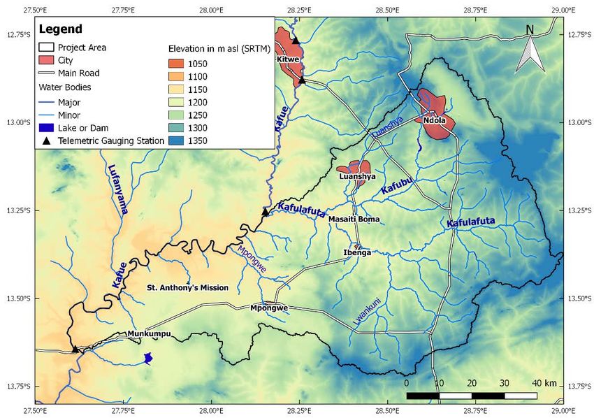
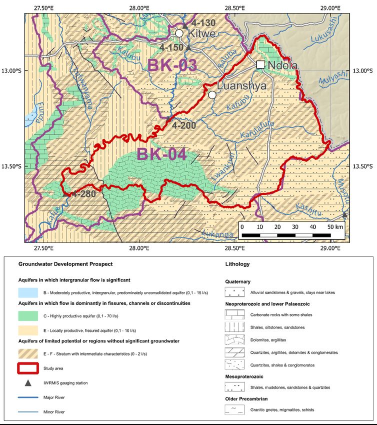
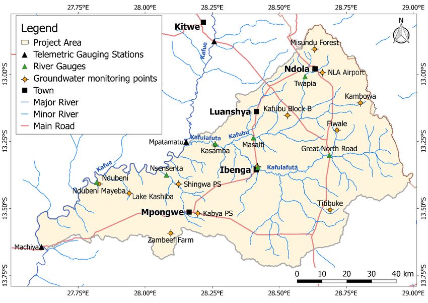
like hydrological and hydrogeological setting, land use and (potential) contamination sites have to
be taken into account to achieve a suitable representation of the conditions monitored. The
number of observations points needed is often determined by financial constraints, yet various
recommendations for minimum densities in the literature exist. The same applies for the required
observation frequency, which is different for quantitative and qualitative aspects and depends on
aquifer type, hydraulic conductivity, recharge amount and groundwater withdrawal, among
others.
All aspects of groundwater monitoring network development are exemplified for a study area of
the GReSP project in the Upper Kafue Sub-Catchment in Zambia. The Groundwater Resources
Management Support Programme (GReSP) is a technical cooperation project between the
Zambian and the German government. The current task of the implementing authorities, the
Water Resources Management Authority (WARMA) and the German Federal Institute for
Geosciences and Natural Resources (BGR), is to develop components of groundwater
management plans, which are prescribed by the Zambian Water Resources Management Act of
2011. These components are derived for a study area encompassing the Kafulafuta Catchment and
the Mpongwe Karst area in Zambia’s Copperbelt Province and include the installation of a
monitoring network.
Coordinated groundwater monitoring is basically absent in Zambia, as only a network of river
gauges exists. According to the water legislation, monitoring responsibilities lie with WARMA and
especially its sub-ordinate structures like catchment and sub-catchment councils (Appendix A.2).
The study area encompasses about 6,880 km², has a temperate-dry winter/hot summer climate
with a clear separation of a dry and a rainy season. A geological map is presented in Appendix A.4.
The area’s geology is dominated by three granite, quartzite and dolomites/limestones – aquifers
typical for large portions of Zambia. The area includes major cities (Ndola, Luanshya) and rural
parts (in the districts of Masaiti and Mpongwe). Land use is fragmented and comprises small-scale
and commercial farmers, which use groundwater for irrigation, urban, mining and industrial areas
(the latter four represent the main water users) while natural vegetation remains occupies only a
minor share of the area. The latter is threatened due to rising need for arable land and charcoal
due to a growing population and industry.
The main objective of the monitoring network was to obtain basic hydro(geo)logical information
of the study area, hence to create an initial regional quantitative reference network. Focus was on
quantitative aspects while qualitative aspects were covered by measurement campaigns. The
network design included both groundwater and river monitoring. The network scale was
determined by the surface water catchments and the main aquifers. Observations points were
distributed using a “stratified random sampling” approach, yet only abandoned boreholes or
handpumps were used to save installation costs, posing a restriction on the locations available. In
total, 9 river monitoring stations and 14 groundwater monitoring stations were chosen. Density of
the groundwater network was therefore 1.9 stations per 1,000 km², which corresponded to a
“well-developed” observation network. Water levels were measured at hourly interval by data
loggers, complemented by occasional discharge and manual measurements (every 2 to 3 months).
Gauge readers were employed for the river gauges, measuring three times a day. The network was
installed between September and November 2016.
Preliminary evaluation of the gathered data showed that the rivers (Kafulafuta and Kafubu) react
very fast to rainfalls in their upper reaches of the catchment and might require higher
measurement frequencies during the rainy seasons. Problems were encountered at some very low
yielding handpumps, but in general it was found that the use of loggers in handpumps is a suitable
and cost-effective way to gather groundwater level data.

 -XI-
In general, the installed network provides basic hydrogeological data. Yet for groundwater
management in the two cities of Ndola and Luanshya, special compliance networks with high
density observations and a focus on hydrochemistry would be needed. Also specific issues like the
continuing impact of deforestation would require additional monitoring efforts. A list of potential
locations to be added, both for rivers and groundwater, is given in this report.
To provide suitable data for management, the maintenance of the monitoring network is key.
Already in the only two years of operation, several repairs had to be conducted (e.g. replacement
of cables or mal-functioning loggers). Since the value of data is strongly impaired by discontinuities
in the records, it has to be assured that sufficient resources are made available to facilitate the on-
going operation of the monitoring efforts.

 -XII-
Introduction

Monitoring of groundwater levels and quality provides essential data needed to develop
groundwater resources, identify changes in quantity or quality over time and to develop and
assess the effectiveness of groundwater management and protection measures, among
others. According to Koreimann et al. (1996) and Jousma & Roelofsen (2004) the first networks
of water table monitoring were established in England and Wales during the mid-19th century,
while the first groundwater quality monitoring network was set up in France in the early
1900s. The U.S. Geological Survey has been collecting water table data for about 120 years
(Taylor & Alley 2001). Despite these first efforts, in most European countries and the U.S.A.
systematic nationwide monitoring of water levels was not established before the period
between 1950 and 1980; systematic groundwater quality monitoring did not start earlier than
1980, and special networks for observing trends in the water quality that may be caused by
diffuse pollution sources as a consequence of land use changes were only installed after 1990
(Jousma & Roelofsen 2004). In many developing countries, including several countries in the
Southern African Development Community (SADC) region, systematic groundwater
monitoring is minimal and still in its early stages. Monitoring in these countries is often limited
to development and observation of groundwater resources for the supply to urban areas
(IGRAC 2013; Jousma & Roelofsen 2004). Unfortunately, many monitoring initiatives that were
initiated by projects or created for the purpose of temporary investigations were not
sustained after completion of the respective projects.
During the last 10 to 20 years, several national and international working groups were
established to develop guidelines for groundwater observation at regional or national scale
with the goal to encourage and establish a systematic and consistent long-term groundwater
quantity and quality monitoring. In Europe, guidelines were developed as part of supporting
the implementation of the new Water Framework Directive (EC 2003; 2007); in the U.S.A. a
sub-committee under the “National Framework for Ground-water Monitoring” published a
similar guiding document (ACWI 2011; 2013); in Australia, the Environment Protection
Authority produced a guideline to provide for a consistent approach to sample groundwater
(Johnston 2007). In South Africa, a toolkit for water service providers and catchment
authorities specifying groundwater monitoring procedures was developed under the
Department of Water Affairs and Forestry (Ravenscroft & Murray 2004). Previously, a UN task
force under the 1992 Convention on the Protection of Transboundary Watercourses and
International Lakes established the then state of the art on groundwater monitoring and
assessment, and proposed guidelines for monitoring transboundary aquifers (Uil et al. 1999;
UN/ECE 2000). Furthermore, the International Groundwater Resources Assessment Centre
(IGRAC) carried out a world-wide inventory of groundwater monitoring (Jousma & Roelofsen
2004) and established a working group, which compiled a report on groundwater monitoring
for general reference purposes (IGRAC 2008).
The UN Convention on the Protection and Use of Transboundary Watercourses and
International Lakes, signed in Helsinki in 1992 (UN 1992) recognizes the need for
measurements to foster the ecologically sound management and protection of water bodies,
including groundwater, which crosses international borders. The Convention requires, among
others, the establishment of programs for monitoring the conditions of transboundary waters
(UN 1992).
In recent years groundwater monitoring has gained additional importance in the context of
assessing the impacts of climate variability. Just like other hydrological elements such as ice,
rivers, lakes and soil moisture, groundwater forms an integral part of the hydrologic cycle and
 -1-
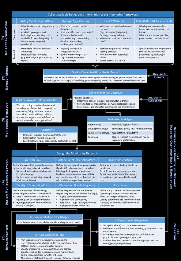
plays an important role in the variability of climate (WMO 2011). Groundwater resources are
related to climate change through recharge processes, governed by the unsaturated zone, or
interaction with surface water bodies and hence, cannot be considered in isolation of the
regional hydrological cycle. Recognizing that there is a lack of groundwater data around the
world, IGRAC initiated the Global Groundwater Monitoring Network (GGMN) in 2007. The
network aims to improve in situ monitoring of groundwater resources and is a partner of the
Global Terrestrial Network Hydrology (GTN-H).
In total, the literature body about groundwater monitoring is large and the purpose of this
report is to summarize the main aspects that have to be considered when developing a
groundwater monitoring network. In addition to this theoretical first part, the second part of
the report presents the application of these considerations for a case study in Zambia.
Part A of this report reviews the state of the art of developing quantitative and qualitative
groundwater monitoring networks. The objectives of Part A are (i) to summarize all relevant
knowledge and information in the literature and (ii) to provide guidance for developing
national and regional groundwater monitoring networks in less developed countries where
no comprehensive network exists or where monitoring is scattered or discontinuous. The
focus is on the development of national, regional and transboundary monitoring networks,
which are designed for the observation of the general status of an aquifer, the identification
of general trends or to provide reference values from unaffected areas for comparison.
Networks on a local scale which are usually designed for areas that are influenced by
interventions (e.g. dropping water levels, pollution) will also be discussed in a general.
Part B of this report describes how the theoretical considerations outlined in Part A and
visualised in a scheme in Appendix A.6 were applied to a project area in the Upper Kafue
Catchment, Zambia. A monitoring network comprising both surface water and groundwater
monitoring sites was drafted and installed. Furthermore, preliminary conclusions about the
future monitoring in the area are drawn based on a first evaluation of the observations made
up to now. An overview of the considerations that were taken into account is given in
Appendix A.5.
A summary of standards or technical regulations of measuring and sampling, construction of
monitoring points, quality assurance, data processing, analysing and reporting is beyond the
scope of this report. A practical overview on these topics was however published by the
German Federal Institute for Geosciences and Natural Resources (BGR) in the framework of
its technical cooperation in the Arab Region (Margane 2004).

 -2-
Part A: Development of a regional groundwater
 monitoring network - A literature review

1. DEFINITIONS
Monitoring in general is defined by UN/ECE (2000) as “the process of repetitive observing, for
defined purposes of one or more elements of the environment according to pre-arranged
schedules in space and time and using comparable methodologies for environmental sensing
and data collection. It provides information concerning the present state and past trends in
environmental behavior.”
In a similar way the International Organization for Standardization (ISO) (in Bartram & Helmer
(1996)) describes monitoring as “the programmed process of sampling, measurement and
subsequent recording or signalling, or both, of various water characteristics, often with the
aim of assessing conformity to specified objectives”.
IGRAC (2008) defines groundwater monitoring as “the scientifically-designed, continuing
measurement and observation of the groundwater situation (including evaluation and
reporting procedures)”.
According to Uil et al. (1999) groundwater monitoring is “the collection of data, generally at
set locations and depths and at regular time intervals in order to provide information which
may be used (i) to determine the state of groundwater both in quantitative and qualitative
sense, (ii) to provide the basis for detecting trends in space and time and (iii) to enable the
establishment of cause-effect relationships”.

2. MONITORING OBJECTIVES
The “underlying” general objective of groundwater monitoring according to Kresic (2009) is
“to describe groundwater characteristics in space and time”.
The primary objective of an individual monitoring well is “to provide an access point for
measuring ground-water levels and to permit the procurement of representative groundwater
samples” (Jousma & Roelofsen 2004).
The following sections provide a summary of objectives of operating groundwater monitoring
networks and for what purposes the data collected may be needed. The summary is based on
information that can be found in various international publications including but not limited
to Koreimann et al. (1996), LAWA (1999a), LAWA (1999b), Uil et al. (1999), UN/ECE (2000), EC
(2003), Jousma & Roelofsen (2004), Chorus et al. (2006), EC (2007), IGRAC (2008) and ACWI
(2011).
The objectives can be grouped under the following categories, which are, however,
interconnected:
 − Objectives related to the general status of groundwater and trends,
 − Objectives related to improved management and support for hydrogeological science,
 − Objectives related to protection of groundwater systems and the environment.

2.1. OBJECTIVES RELATED TO THE GENERAL STATUS OF GROUNDWATER AND TRENDS
Individual objectives under this category include:

 -3-
i. To provide a general characterization of a groundwater system, i.e. its chemical and
 quantity status as well as spatial and temporal patterns and variability;
 ii. To determine the potentiometric surface and establish the position of groundwater
 divides and areas of infiltration and seepage, to estimate the direction and rate of
 flow (including transboundary flow) and detect changes in flow directions and
 interactions between groundwater and surface water;
 iii. To provide background information for classifying the chemical status of groundwater,
 to assess the state of contamination of a groundwater body, to identify associated
 contamination risks (large-scale/diffuse or point source) and to determine its
 suitability for different types of use (i.e. drinking water, irrigation, etc.);
 iv. To identify general trends in time in groundwater discharge and storage as well as
 quality and to assess to which extent they are related (and may respond) to human
 activities (i.e. groundwater abstraction and land use change) or changes in natural
 conditions such as climate variability;
 v. To gather periodical information on the actual status of groundwater for management
 or publication (e.g. yearbooks).

2.2. OBJECTIVES RELATED TO IMPROVED MANAGEMENT AND SUPPORT FOR
HYDROGEOLOGICAL SCIENCE

Individual objectives under this category include:
 i. To provide groundwater data for a sustainable development of the groundwater
 resources, the assessment of the potential for water supply and the optimization of
 groundwater withdrawal;
 ii. To support an integrated pro-active management of groundwater resources that
 avoids depletion or contamination of aquifers and helps to control the balance
 between matters of common interest;
 iii. To determine and assess the impact of management and remedial measures and to
 assist in the design of additional measures;
 iv. To provide reference values for detailed investigations, e.g. related to sustainable
 groundwater usage, protection zoning or construction;
 v. To provide data to estimate groundwater recharge;
 vi. To meet specific research goals, i.e. to provide inputs for numerical modeling of
 groundwater flow or contaminant transport ;
 vii. To allow early-warning, e.g. of the impact of diffuse sources of pollution in recharge
 areas.

2.3. OBJECTIVES RELATED TO PROTECTION OF GROUNDWATER SYSTEMS AND THE
ENVIRONMENT

Individual objectives under this category include:
 i. To establish the effects on groundwater quality from contamination by diffuse, line or
 point sources of pollution (e.g. by application of agrichemicals, nutrient impacts,
 landfills, geological sequestration of carbon dioxide, etc.), and to provide data to avoid
 contamination during drilling and construction;
 ii. To provide data for prevention of unacceptable impacts on surface waters and
 wetlands and for protection of nature conservation areas from unacceptably declining
 water tables;
 iii. To provide data for control of saline water intrusion or up-coning in aquifers resulting
 from alteration of flow;
 iv. To provide data for control of land subsidence caused by groundwater abstraction.

 -4-
3. NETWORK TYPES
Unfortunately, the terms developed in the literature to describe monitoring network types
such as “regional”, “local”, “primary”, “secondary”, “baseline” and “surveillance” monitoring
are not used in a consistent manner. Instead, they are used with sometimes similar but not
identical meanings.
The criteria used to distinguish network types include the size of a monitoring network, its
development stage, the parameters observed or the various functions a network must fulfil.

3.1. NETWORK TYPES WITH RESPECT TO ITS SIZE
With respect to the size of a network large “regional” networks covering aquifers of large
regional size (including “sub-national”, “national” and “transboundary” aquifers) can be
distinguished from “local” networks designed for specific requirements at local sale (including
networks around well fields and pollution sites) (IGRAC 2008). Local and regional networks are
often combined to a wide-spaced regional network with denser-spaced parts in areas of
particular interest (Jousma & Roelofsen 2004).

3.2. NETWORK TYPES WITH RESPECT TO ITS DEVELOPMENT STAGE
With respect to the development stage of a monitoring network Van Bracht (2001, in Margane
(2004)) distinguishes between “pilot/extended pilot” networks, “final” networks and
“optimized final” networks. In a comparable way the reports by Jousma & Roelofsen (2004),
IGRAC (2008) and ACWI (2013) emphasize the need of “initial” or “baseline” monitoring for
up to 5 years during which information regarding groundwater characteristics is scarce. Pilot
networks aim at an initial description of water levels and quality and their natural variability
and at a preliminary assessment of the regional characteristics and potential of aquifers. Once
baseline data are gathered, the monitoring network can be evaluated and optimized. A broad
range of optimization approaches can be used for this purpose (Mishra & Coulibaly 2009).

3.3. NETWORK TYPES WITH RESPECT TO PARAMETERS OBSERVED
With respect to the observed parameters quantitative networks focusing on variations of
water level and discharge in space and time are distinguished from networks for monitoring
groundwater quality (e.g. EC (2007)).

3.4. NETWORK TYPES WITH RESPECT TO ITS FUNCTIONS
It is essential that a network is “tailor-made” to the information needs, and observation points
are linked to the objectives and requirements defined by groundwater management (Mäkelä
& Meybeck (1996), Timmerman & Mulder (1999), Jousma & Roelofsen (2004)). It therefore
makes sense to define network types with respect to the functions the network needs to fulfil.
The terminology used below to distinguish networks with respect to their functions mainly
follows the proposals by Uil et al. (1999) and Kresic (2009).
 i. “Basic/reference” monitoring refers to networks, which are designed to establish
 background or enhance existing water quality and quantity data such as water levels
 and discharge of regional water resources, and to collect continuous data to enable
 determination of long-term natural trends or the effect of slowly changing
 anthropogenic activities. Other terms used for such a network or a network with
 similar functions include “ambient” (Bloomfield 2000; Kresic 2009), “background”
 (Van Lanen 2004), “strategic” (Uil et al. (1999), UK Environmental Agency (2006))

 -5-
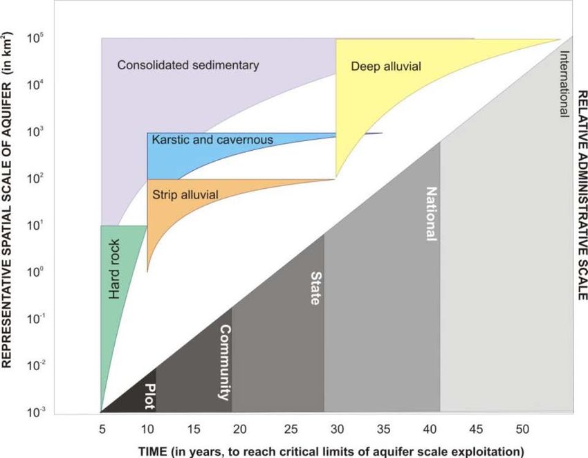
“primary” (IGRAC 2008), and “surveillance” (ACWI 2013; EC 2007) network. The report
 by ACWI (2013) further distinguishes between networks in aquifers under “unstressed
 (background)” conditions, for monitoring points located in undisturbed portions of
 aquifers, and “targeted” areas, for monitoring points located in areas that are
 undergoing slow changes in groundwater or land use.
 ii. “Compliance” monitoring is needed to assess whether groundwater use complies with
 existing regulation and standards. It is usually linked to a specific purpose and aquifers
 considered at risk, e.g. to measure concentrations of pollutants near facilities where
 groundwater contamination has occurred, to assess the risk of suspected sources of
 contamination or the effectiveness of remedial measures. For similar network types
 the terms “regulatory” (Ravenscroft & Murray 2004), “operational” (EC 2007), and
 “special studies” (ACWI 2013) or “specific” (Van Lanen 2004) network were used.
 iii. “Early warning” or also termed “sentinel” monitoring networks are built upstream of
 a water production well or spring capture and are used to provide early warning
 against pollution of drinking water where accidental spills or hazardous waste could
 harm drinking water quality. Some consider early warning a special type of compliance
 monitoring.
 iv. “Performance” monitoring refers to measuring quantity and quality associated with
 water supply pumping and remediation on a regular basis.
It should be added that basic/reference monitoring networks usually correspond to regional
networks whereas compliance, early warning and performance monitoring can be considered
special studies with monitoring at local scale around well fields or contamination sites.

4. RESPONSIBILITIES
The principal obligations to monitor groundwater use are usually laid down in the national
water legislation. Detailed requirements of a monitoring network that should also include
coordination of data gathering, interpretation and storage are often contained in subsidiary
legislation or technical standards and guidelines (Mechlem 2012).
The type and spatial scale of the aquifers influence the relative administrative scale of
groundwater management – from private to international level - as illustrated in Figure 1.
However, administrative scale might also differ with the size of a country.
The overall responsibility for monitoring activities supporting groundwater management and
the supervision of delegated tasks lies in the hands of the competent central (national or
regional) governmental institution. With respect to water quality protection, this is often the
Ministry of Health, Ministry of Environment and Natural Resources or a national
environmental protection agency. The Ministry of Water or a national water resources
management authority is usually responsible for water resources management, which
includes surveillance of sustainable use of groundwater and monitoring of groundwater
development.

 -6-
Figure 1: Relationship between spatial scale and type of aquifer, critical response time and relative
administrative scale (from Moench et al. (2014), p. 29).
Irrespective of which specific state institution has been granted the legal authority for
overseeing groundwater monitoring, it is crucial that the function of supervision and
regulatory compliance is strictly separated from the function of controlling the safety and
quality of water supplied, and that both are performed by separate independent entities
because of conflict of interests that may arise when they are combined (WHO 2008; 2014).
The surveillance agency is responsible for monitoring of compliance with supply service
standards regarding quality and quantity, and should be given necessary powers to enforce
laws and regulations. Water utility companies are responsible at all times for the quality of
the water they supply and liable for failure in quality. State institutions are usually in charge
of basic/reference and compliance monitoring while water utilities and developers are
responsible for performance monitoring. However, performance monitoring has to be
supervised by state institutions by providing guidelines, certifying laboratory standards and, if
necessary, check measurements. Monitoring by the water administration and large water
utilities should be complemented by information provided by well owners on their
abstractions (Mechlem 2012). Table 1 provides a typical division of responsibilities of state
institutions and private entities for common tasks related to groundwater monitoring.

 -7-
Table 1: Division of responsibilities for groundwater monitoring (modified after IGRAC (2008) and
Kresic (2009))

 Requirement, Task Function Responsibility
 (Network Type)
 Baseline or reference groundwater Basic/reference Central Government or National
 monitoring or monitoring of trends at monitoring Water Authority
 national and regional (basin) levels Regional Government or Basin
 Authority
 Collection of data to meet specific Research Project teams commissioned by
 research goals monitoring research institutions
 Monitoring of effluents Compliance or Central Government (but paid for by
 early-warning operator) or operator under
 monitoring supervision/surveillance of
 regulatory or local authority
 Monitoring of spills at site level Compliance or Central Government (or ordered by
 early-warning Government and paid by polluter);
 monitoring in case of diffuse pollution paid and
 conducted by Central Government
 Monitoring of saltwater intrusion near Compliance or Central Government, the company
 abstraction areas early-warning over-abstracting could be made
 monitoring accountable
 Monitoring of compliance with Early-warning Water utility company or respective
 drinking water standards at sentinel monitoring large groundwater developer*
 wells near large water supply wells
 Monitoring of metered groundwater Performance Water utility company or respective
 abstraction and drawdown of well monitoring large groundwater developer*
 fields
 General feedback on abstraction from Performance Small groundwater developer
 small developments monitoring (utility) or commercial farm*
* Monitoring has to be supervised by respective state institution(s).

5. NETWORK DESIGN
5.1. GENERAL CONSIDERATIONS IN DEVELOPING A GROUNDWATER MONITORING
PROGRAM

Designing a monitoring program is a complex process and usually involves an iterative
procedure (IGRAC 2008). According to the European Environmental Agency (EEA 2008) and
Johnston (2007) considerations to be included in the development of a groundwater
monitoring program comprise the monitoring objective, the hydrogeological setup (type and
complexity of main aquifers), the spatial extent of existing or expected impacts of withdrawals
or pollution, existing monitoring systems, the precision and accuracy required to reach the
objectives as well as logistical and cost aspects (Figure 2).

 -8-
Considerations: Elements: − Monitoring objective − Duration of sampling Monitoring Plan (What is to be monitored − Location and number of and why?) sampling points − Hydrogeological setting − Frequency of sampling − Spatial extent of impacts − Analytes/parameters − Precision/accuracy − Method of sampling required (e.g. grab, automatic) − Logistical OHS&W1) − Responsible persons issues − Costs 1) Occupational Health, Safety and Welfare Figure 2: Development of a monitoring plan according to Johnston (2007). Essentially all existing guidelines emphasize that the monitoring objectives and resulting information needs must be carefully analysed and identified. It is furthermore recommended to clearly link functions of individual observation points to the various objectives and data requirements defined by the groundwater monitoring program (Jousma & Roelofsen 2004). For the continuity of a monitoring program, it is considered critical that the collected data is useful and tailored to management requirements. To quote just one example of this, there would be no particular merit in frequent groundwater sampling for analysis of major ions once the baseline aquifer quality has been established (Morris et al. 2003). Regarding available resources and costs it may be necessary to prioritize monitoring activities. The prioritizing requires the identification and assessment of threats such as potential pollution sources, areas of over-exploitation or land subsidence. The prioritizing of quality networks could be achieved by making use of risks assessments which may be in parts derived from aquifer vulnerability maps (IGRAC 2008). For quantitative networks, the various uses and functions of groundwater (e.g. drinking water supply, agricultural use, industrial use, conservation of wetlands and minimum baseflow, etc.) should be identified and subsequently, the risks and possible damage regarding the preservation of these functions evaluated. Estimated abstraction volumes, expected three-dimensional extent of drawdown and population density are among the factors that should be considered in a risk assessment. The final prioritization could be achieved by establishing functions and risk tables to define whether the issues are in conflict with the functions of the groundwater systems (Chave et al. 2006; UN/ECE 2000). The preliminary characterization of the hydrogeological framework and the conditions of groundwater flow is regarded an essential major precondition for the development of a monitoring program according to the relevant literature (e.g. Bloomfield (2000), UN/ECE (2000), Jousma & Roelofsen (2004), EC (2007), Kresic (2009)). Regarding the hydrogeological setup recharge and discharge areas and the extent of aquifers and aquitards, both horizontally and vertically, and their respective potential for groundwater use should be known. Regarding hydro-geochemistry knowledge about the dominant geochemical processes, the natural or background situation, aquifer vulnerability as well as threats from actual or potential pollution sources should be gained in the course of developing a monitoring program. Furthermore, it is useful to evaluate - to the extent that existing data permit - water-level trends or seasonal fluctuations, local hydrological influences such as abstractions, the variability in natural geochemical conditions and the behavior of pollutant(s). -9-
In addition, criteria related to logistics and the specific local conditions such as accessibility,
ownership, required protective measures, and the availability of an observation point over a
long enough period need to be considered.

5.2. COMPARISON OF GROUNDWATER WITH CLIMATE/METEOROLOGICAL MONITORING
As groundwater takes part in the hydrological cycle and plays an important role in the
variability of climate, general concepts of climate monitoring may - to some extent - also be
applicable to regional monitoring of groundwater volumes. Compared to the fields of
hydrology/hydrogeology global cooperation is much more advanced in meteorology as
meteorological processes are mostly on a global scale and require standardized international
coordination whereas most hydrological tasks arise on a catchment scale. The World
Meteorological Organization’s (WMO) guidance on climate observations, networks and
stations is among others based on the ten climate monitoring principles (WMO/TD-No.847, in
WMO (2011)). The ten principles are included in Appendix A.1 of this document. Principles
no. 2 and 5 to 7 are unrestrictedly valid for groundwater monitoring as well:
 − “A suitable period of overlap for new and old observation systems is required“
 (Principle no. 2).
 − “Consideration of the needs for environmental and climate monitoring products and
 assessments should be integrated into national, regional and global observing
 priorities” (Principle no. 5).
 − “Operation of historically uninterrupted stations and observing systems should be
 maintained” (Principle no. 6).
 − “High priority for additional stations should be focused on data poor areas, poorly
 observed parameters, areas sensitive to change and key measurements with
 inadequate temporal resolution” (Principle no. 7).
It has been stated that at least ten years of daily observations are necessary to produce the
relevant statistical parameters for most meteorological elements, and at least thirty years for
precipitation (WMO 2011). Due to the slow movement in groundwater with relatively large
residence times, the storage behavior of groundwater reservoirs, and the considerable degree
of chemical interaction between water and aquifer material (EEA 2008), groundwater levels
and quality, however, behave overall less erratically and hence have statistical properties that
are quite different to, for instance, rainfall. Nevertheless, time series over a duration of not
less than 10 years and sometimes up to several decades are required to compile hydrological
records of groundwater level fluctuations which enable a reliable estimation of the potential
range of water-level fluctuations in an observation well and to track long-term trends with
time Taylor & Alley (2001).
Finally, it is worthwhile to take a look at minimum requirements of meteorological networks
regarding the network density and spacing of observation points. According to the WMO
Guide to Climatological Practices (WMO 2011), the density of a “Regional Basic Synoptic
Network” (for the provision of average monthly climatological data) should not be less than 1
to 10 stations per 250,000 km², and stations of such a network should have a maximum
average separation of not less than 500 km. Compared to existing groundwater networks in
western states, however, this represents a very low network density (Chapter 5.4.4). In
connection with requirements towards the implementation of the meteorological Global
Observing System (GOS) it was acknowledged that the interval between surface synoptic
stations should not exceed 250 km, or 300 km in sparsely populated areas (Bojinski 2010;
WMO 2010-2017). WMO technical regulations (WMO 1988) require that the minimal
horizontal resolution of surface stations should be between 100 km (e.g. for temperature and

 -10-
rainfall) and 250 km (e.g. for river runoff and water quality) to meet the needs of WMO
programs for international exchange.

5.3. RELEVANCE OF SURFACE WATER MONITORING FOR GROUNDWATER MONITORING
(AND VICE VERSA)
Surface water and groundwater bodies are mutually interlinked and their monitoring has to
be considered in an integrated way. Groundwater can sustain large portions of streamflows,
especially in rain-free periods, and is often connected to standing surface waters like lakes
and reservoirs. Monitoring of surface waters can therefore allow drawing conclusions on the
groundwater status. Deep and fossil aquifers might present an exception as they operate on
a time scale that strongly differs from those of other water cycle components.
Both surface water and groundwater are typically assessed on catchment basis, for which a
water budget can be formulated as (cf. Healy (2010))

 + , + , = + ∆ + , + , (1)

where P is precipitation (including irrigation), ET is actual evapotranspiration, ΔS is water
storage change, and Qi,sw and Qi,gw are surface and groundwater flow into the catchment,
respectively. Likewise Qo,sw and Qo,gw are surface and groundwater flow out of the
catchment, respectively. All components refer to rates, typically given as mm per time unit,
where mm equals liter per m². Over longer time periods (i.e., several years) ΔS is commonly
assumed to vanish. For periods in which it has to be considered, it can be divided into sub-
components like storage change in surface water bodies (ΔSsw), groundwater (ΔSgw) and the
unsaturated zone (ΔSuz) (Healy & Cook 2002). As water budgets are mostly set up based on
surface water catchments, Qi,sw should, by definition, be zero except for artificial (piped)
inter-basin water transfers. Qo,sw is the catchment runoff, being the sum of runoff generated
by rainfall and baseflow (Qbf), which is defined as the groundwater component of stream
flow drained from adjacent aquifers. Baseflow can be an important or even the only
contribution to streamflow, especially during droughts or seasons without rainfalls. The
baseflow is also of importance for estimating groundwater recharge of a catchment based
on the water budget

 = , − , + + + ∆ (2)

where ETgw is the evapotranspiration sustained by groundwater and Qo,gw - Qi,gw is the net
subsurface flow from or to the study area, which includes abstractions by pumping (Healy &
Cook 2002). In case the remaining terms on the right-hand side of Equation 2 are very small,
baseflow allows drawing conclusions on the groundwater recharge.
Considerations of the design of river monitoring networks differs from those of groundwater
monitoring networks. For instance, river gauges should be positioned close to the outlets of
catchments or sub-catchments in order to be representative for most parts of the area. In
selecting a proper site, different criteria have to be taken into account (e.g. no flow
obstacles, straight stream reach) (Rantz & others 1982a; b; WMO 2010). In comparison to
groundwater levels, accessibility of the site might be of higher importance as regular
discharge measurements have to be done to generate a rating curve (i.e. a relationship
between water level and discharge). In addition, river water levels require higher
measurement frequencies as they react much faster to meteorological boundary conditions
than groundwater levels.
Groundwater monitoring points should be located close to surface water gauges, as
comparing both water level measurements can serve as indicator for the interaction
between groundwater and surface water. Flow can be either directed towards the river (i.e.
 -11-
exfiltration of groundwater) or towards the groundwater (i.e. infiltration of surface water).
The flow direction might change during the seasons or as consequence of massive
groundwater abstraction in the vicinity of the river. Quantifying this flow by one of available
approaches (Kalbus et al. 2006) might be important to estimate the water budget.

5.4. GROUNDWATER MONITORING DESIGN COMPONENTS
The design of monitoring networks that are representative for a groundwater body includes
the following components (ACWI 2013; UN/ECE 2000):
 − The identification of aquifers to be monitored, which determines the scale of the
 network;
 − the determination of the location (distribution), in three dimensions, of observation
 points within aquifers;
 − the selection of types of observation and sampling points included in the network;
 − the specification of the network’s spatial density;
 − the specification of monitoring time frames and observation/sampling frequency;
 − the choice of measured parameters and water-quality analytes.
All design components of a monitoring network depend on the objectives pursued, the
hydrogeological situation and, as a matter of fact, on the available resources. All nationally
important aquifers should be observed, including aquifers not being used at the time (EEA
2008). As pointed out by Chilton & Foster (1996) the location and density of observation points
will largely depend on the complexity of the hydrogeological situation, the lithology, aquifer
distribution and land use patterns whereas the sampling frequency will be mainly determined
from flow velocities, residence times and seasonal influences (i.e. hydrology). The choice of
the parameters to be observed will be largely dependent on dominant geochemical processes,
water quality issues and statutory requirements (Table 2).
Table 2: Main factors determining the network design (after Chilton & Foster (1996))

 Design Type, location and Observation frequency Choice of determinants
 component density
 of observation points
 Major − Objective pursued − Objective pursued − Objective pursued
 controlling (network type) (network type) (network type)
 factors − Hydrogeology − Hydrogeology − Hydrogeology
 (complexity) (residence time) (geochemical
 − Lithology − Climate/hydrology processes)
 (aquifer distribution) (seasonal variations) − Water quality issues
 − Land use − Costs − Statutory
 − Costs requirements
 − Costs

It should be mentioned that in the literature (e.g. Uil et al. (1999), UN/ECE (2000)) the design
of a groundwater monitoring program is sometimes defined in a broader sense and may
include e.g. well construction requirements, comparable field methods and protocols (SOPs),
laboratory standards, definition of agreements between data providers, and a data and geo-
information management systems that allow access to data.

 -12-
You can also read