STATE OF THE CLIMATE IN 2020 - THE ARCTIC M. L. Druckenmiller, T. Moon, and R. Thoman, Eds.
←
→
Page content transcription
If your browser does not render page correctly, please read the page content below
STATE OF THE CLIMATE IN 2020
                THE ARCTIC
                M. L. Druckenmiller, T. Moon, and R. Thoman, Eds.

Special Online Supplement to the Bulletin of the American Meteorological Society Vol.102, No. 8, August, 2021

https://doi.org/10.1175/BAMS-D-21-0086.1
Corresponding author: Matthew L. Druckenmiller / druckenmiller@colorado.edu
©2021 American Meteorological Society
For information regarding reuse of this content and general copyright information, consult the AMS Copyright Policy.

                AU G U S T 2 0 2 1 | S t a t e o f t h e C l i m a t e i n 2 0 2 0                                     5. THE ARCTIC   S263
STATE OF THE CLIMATE IN 2020
                            The Arctic

                                                                         Editors

                                                                     Jessica Blunden
                                                                        Tim Boyer

                                                                     Chapter Editors

                                                                 Freya Aldred
                                                                 Peter Bissolli
                                                             Howard J. Diamond
                                                           Matthew L. Druckenmiller
                                                              Robert J. H. Dunn
                                                              Catherine Ganter
                                                               Nadine Gobron
                                                             Gregory C. Johnson
                                                                 Rick Lumpkin
                                                                     Tim Li
                                                              Ademe Mekonnen
                                                                John B. Miller
                                                                Twila A. Moon
                                                             Ahira Sánchez-Lugo
                                                               Ted A. Scambos
                                                              Carl J. Schreck III
                                                            Sharon Stammerjohn
                                                             Richard L. Thoman
                                                               Kate M. Willett

                                                                     Technical Editor

                                                                     Andrea Andersen

                                                   BAMS Special Editor for Climate

                                                               Michael A. Alexander

                                                  American Meteorological Society

AU G U S T 2 0 2 1 | S t a t e o f t h e C l i m a t e i n 2 0 2 0                      5. THE ARCTIC   S264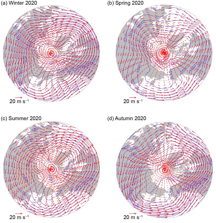
Cover credit:
Stefan Hendricks / Alfred Wegener Institute CC-BY 4.0
Date: 2019-10-16-Location: Arctic Ocean, 84.765482°N, 133.905373°E
The crew of the research icebreaker Polarstern inspects the ice anchors after a sea ice fractur-
ing event at the early stages of the Multidisciplinary drifting Observatory for the Study of Arctic
Climate (MOSAiC) experiment.

The Arctic is one chapter from the State of the Climate in 2020 annual report and is available
from https://doi.org/10.1175/BAMS-D-21-0086.1. Compiled by NOAA’s National Centers for
Environmental Information, State of the Climate in 2020 is based on contributions from
scientists from around the world. It provides a detailed update on global climate indicators,
notable weather events, and other data collected by environmental monitoring stations and
instruments located on land, water, ice, and in space.
The full report is available from https://doi.org/10.1175/2021BAMSStateoftheClimate.1.

How to cite this document:

Citing the complete report:
Blunden, J. and T. Boyer, Eds., 2021: “State of the Climate in 2020”. Bull. Amer. Meteor. Soc., 102
(8), Si–S475, https://doi.org/10.1175/2021BAMSStateoftheClimate.1

Citing this chapter:
Druckenmiller, M. L., T. Moon, and R. Thoman, Eds., 2021: The Arctic [in “State of the Climate in
2020”]. Bull. Amer. Meteor. Soc., 102 (8), S263–S315, https://doi.org/10.1175/BAMS-D-21-0086.1

Citing a section (example):
Holmes, R. M., A. I. Shiklomanov, A. Suslova, M. Tretiakov, J. W. McClelland, L. Scott,
R. G. M. Spencer, and S. E. Tank, 2021: River discharge [in “State of the Climate in 2020”].
Bull. Amer. Meteor. Soc., 102 (8), S290–S292, https://doi.org/10.1175/BAMS-D-21-0086.1.

 AU G U S T 2 0 2 1 | S t a t e o f t h e C l i m a t e i n 2 0 2 0                     5. THE ARCTIC   S265
Editor and Author Affiliations (alphabetical by name)

Ballinger, Thomas J., International Arctic Research Center, University of Alaska      Ialongo, Iolanda, Finnish Meteorological Institute, Helsinki, Finland
    Fairbanks, Fairbanks, Alaska                                                      Isaksen, K., Norwegian Meteorlogical Institute, Blindern, Oslo, Norway
Berner, Logan T., School of Informatics, Computing, and Cyber Systems,                Jain, Piyush, Natural Resources Canada, Canadian Forest Service, Northern
    Northern Arizona University, Flagstaff, Arizona                                       Forestry Centre, Edmonton, Alberta, Canada
Bernhard, Germar H., Biospherical Instruments Inc., San Diego, California             Johnsen, Bjørn, Norwegian Radiation and Nuclear Safety, Østerås, Norway
Bhatt, Uma S., Geophysical Institute, University of Alaska Fairbanks, Fairbanks,      Kaleschke, L., Alfred Wegener Institute, Helmholtz Centre for Polar and Marine
    Alaska                                                                                Research, Bremerhaven, Germany
Bjerke, Jarle W., Norwegian Institute for Nature Research, FRAM – High North          Kholodov, A. L., Earth Cryosphere Institute, Tyumen Science Center, Tyumen,
    Research Centre for Climate and the Environment, Tromsø, Norway                       Russia
Box, Jason E., Geological Survey of Denmark and Greenland, Copenhagen,                Kim, Seong-Joong, Korea Polar Research Institute, Incheon, Republic of Korea
    Denmark                                                                           Korsgaard, Niels J., Geological Survey of Denmark and Greenland,
Brown, R., Climate Research Division, Environment and Climate Change                      Copenhagen, Denmark
    Canada, Montréal, Quebec, Canada                                                 Labe, Zachary, Colorado State University, Fort Collins, Colorado
Cappelen, John, Danish Meteorological Institute, Copenhagen, Denmark                  Lakkala, Kaisa, Finnish Meteorological Institute, Sodankylä, Finland
Christiansen, Hanne H., Geology Department, University Centre in Svalbard,            Lara, Mark J., Department of Plant Biology, University of Illinois at Urbana-
    The University Center in Svalbard, Longyearbyen, Norway                               Champaign, Urbana, Illinois
Decharme, B., Centre National de Recherches Météorologiques, Toulouse,              Loomis, Bryant, NASA Goddard Space Flight Center, Greenbelt, Maryland
    France                                                                            Luojus, K., Arctic Research Centre, Finnish Meteorological Institute, Helsinki,
Derksen, C., Climate Research Division, Environment and Climate Change                    Finland
    Canada, Downsview, Ontario, Canada                                                Macander, Matthew J., ABR, Inc. Environmental Research & Services,
Divine, Dmitry, Norwegian Polar Institute, Fram Centre, Tromsø, Norway                    Fairbanks, Alaska
Drozdov, D. S., Earth Cryosphere Institute, and Tyumen State University,              Malkova, G. V., Earth Cryosphere Institute, Tyumen Science Center, Tyumen,
    Tyumen, Russia                                                                        Russia
Druckenmiller, Matthew L., National Snow and Ice Data Center, Cooperative             Mankoff, Kenneth D., Geological Survey of Denmark and Greenland,
    Institute for Research in Environmental Sciences at the University of                 Copenhagen, Denmark
    Colorado, Boulder, Colorado                                                       Manney, Gloria L., NorthWest Research Associates, Socorro, New Mexico
Elias Chereque, A., Department of Physics, University of Toronto,                     McClelland, James W., University of Texas at Austin, Marine Science Institute,
    Toronto, Canada.                                                                      Port Aransas, Texas
Epstein, Howard E., Department of Environmental Sciences, University of               Meier, Walter N., National Snow and Ice Data Center, Cooperative Institute for
    Virginia, Charlottesville, Virginia                                                   Research in Environment Sciences at the University of Colorado, Boulder,
Farquharson, L. M., Geophysical Institute, University of Alaska Fairbanks,                Colorado
    Fairbanks, Alaska                                                                 Moon, Twila A., National Snow and Ice Data Center, Cooperative Institute for
Farrell, Sinead L., Department of Geographical Sciences, University of                    Research in Environmental Sciences at the University of Colorado, Boulder,
    Maryland, College Park, Maryland                                                      Colorado
Fausto, Robert S., Geological Survey of Denmark and Greenland, Copenhagen,            Mote, Thomas, Department of Geography, University of Georgia, Athens,
    Denmark                                                                               Georgia
Fettweis, Xavier, SPHERES research unit, University of Liège, Liège, Belgium        Mudryk, L., Climate Research Division, Environment and Climate Change
Fioletov, Vitali E., Environment and Climate Change Canada, Toronto, Ontario,             Canada, Downsview, Ontario, Canada
    Canada                                                                            Müller, Rolf, Forschungszentrum Jülich, Jülich, Germany
Forbes, Bruce C., Arctic Centre, University of Lapland, Rovaniemi, Finland            Nyland, K. E., Department of Geography, George Washington University,
Frost, Gerald V., ABR, Inc. Environmental Research & Services, Fairbanks,                 Washington, D.C.
    Alaska                                                                            Overland, James E., NOAA/OAR Pacific Marine Environmental Laboratory,
Gargulinski, Emily, National Institute of Aerospace, Resident at NASA LaRC,               Seattle, Washington
    Hampton, Virginia                                                                 Park, T., NASA Ames Research Center, Mountain View, California, and Bay Area
Gerland, Sebastian, Norwegian Polar Institute, Fram Centre, Tromsø, Norway                Environmental Research Institute, Moffett Field, California
Goetz, Scott J., School of Informatics, Computing, and Cyber Systems, Northern        Pavlova, Olga, Norwegian Polar Institute, Fram Centre, Tromsø, Norway
    Arizona University, Flagstaff, Arizona                                            Perovich, Don, Thayer School of Engineering, Dartmouth College, Hanover,
Grabinski, Z., Alaska Fire Science Consortium, International Arctic Research              New Hampshire
    Center, University of Alaska, Fairbanks, Alaska                                   Petty, Alek, NASA Goddard Space Flight Center, Greenbelt, Maryland
Grooß, Jens-Uwe, Forschungszentrum Jülich, Jülich, Germany                          Phoenix, Gareth K., Department of Animal and Plant Sciences, University of
Haas, Christian, Alfred Wegener Institute, Helmholtz Centre for Polar and                 Sheffield, Sheffield, United Kingdom
    Marine Research, Bremerhaven, Germany                                             Raynolds, Martha K., Institute of Arctic Biology, University of Alaska,
Hanna, Edward, School of Geography and Lincoln Centre for Water and                       Fairbanks, Alaska
    Planetary Health, University of Lincoln, Lincoln, United Kingdom                  Reijmer, C. H., Institute for Marine and Atmospheric Research Utrecht, Utrecht
Hanssen-Bauer, Inger, Norwegian Meteorological Institute, Blindern, Oslo,                 University, Utrecht, The Netherlands
    Norway                                                                            Richter-Menge, Jacqueline, University of Alaska Fairbanks, Institute of
Hendricks, Stefan, Alfred Wegener Institute, Helmholtz Centre for Polar and               Northern Engineering, Fairbanks, Alaska
    Marine Research, Bremerhaven, Germany                                             Ricker, Robert, Alfred Wegener Institute, Helmholtz Centre for Polar and
Holmes, Robert M., Woodwell Climate Research Center, Falmouth,                            Marine Research, Bremerhaven, Germany
    Massachusetts

                 AU G U S T 2 0 2 1 | S t a t e o f t h e C l i m a t e i n 2 0 2 0                                                     5. THE ARCTIC          S266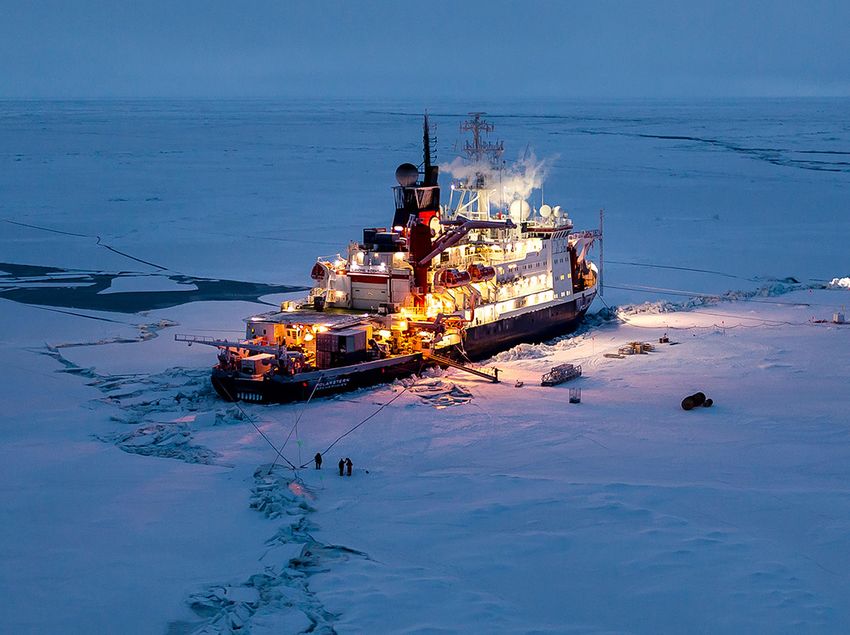
Editor and Author Affiliations (alphabetical by name)

Romanovsky, Vladimir E., Geophysical Institute, University of Alaska                 Timmermans, Mary-Louise, Yale University, New Haven, Connecticut
    Fairbanks, Fairbanks, Alaska; Earth Cryosphere Institute, Tyumen Science         Tømmervik, Hans, Norwegian Institute for Nature Research, FRAM and High
    Center, Tyumen, Russia                                                               North Research Centre for Climate and the Environment, Tromsø, Norway
Scott, Lindsay, Woodwell Climate Research Center, Falmouth, Massachusetts            Tretiakov, Mikhail, Arctic and Antarctic Research Institute, St. Petersburg,
Shapiro, Hazel, Arctic Research Consortium of the United States, Fairbanks,              Russia
    Alaska                                                                           Tschudi, Mark, Aerospace Engineering Sciences, University of Colorado,
Shiklomanov, Alexander I., University of New Hampshire, Durham, New                      Boulder, Colorado
    Hampshire; Arctic and Antarctic Research Institute, St. Petersburg, Russia       Vakhutinsky, Sofia, National Snow and Ice Data Center, Cooperative Institute
Shiklomanov, Nikolai I., Department of Geography, George Washington                      for Research in Environmental Sciences at the University of Colorado,
    University, Washington, D.C.                                                         Boulder, Colorado
Smeets, C. J. P. P., Institute for Marine and Atmospheric Research Utrecht,          van As, Dirk, Geological Survey of Denmark and Greenland, Copenhagen,
    Utrecht University, Utrecht, The Netherlands                                         Denmark
Smith, Sharon L., Geological Survey of Canada, Natural Resources Canada,             van de Wal, R. S. W., Institute for Marine and Atmospheric Research Utrecht
    Ottawa, Ontario, Canada                                                              and Department of Physical Geography, Utrecht University, Utrecht, The
Soja, Amber, National Institute of Aerospace, Resident at NASA LaRC,                     Netherlands
    Hampton, Virginia                                                                Veraverbeke, Sander, Faculty of Science, Vrije Universiteit Amsterdam, The
Spencer, Robert G. M., Florida State University, Tallahassee, Florida                    Netherlands
Starkweather, Sandy, Cooperative Institute for Research in Environmental             Walker, Donald A., Institute of Arctic Biology, University of Alaska Fairbanks,
    Sciences, University of Colorado Boulder and Earth System Research                   Fairbanks, Alaska
    Laboratory, NOAA, Boulder, Colorado                                              Walsh, John E., International Arctic Research Center, University of Alaska
Streletskiy, Dimitri A., Department of Geography, George Washington                      Fairbanks, Fairbanks, Alaska
    University, Washington, D.C.                                                     Wang, Muyin, NOAA/OAR Pacific Marine Environmental Laboratory, and
Suslova, Anya, Woodwell Climate Research Center, Falmouth, Massachusetts                 Cooperative Institute for Climate, Ocean, and Ecosystem Studies, University
Svendby, Tove, NILU‐Norwegian Institute for Air Research, Kjeller, Norway                of Washington, Seattle, Washington
Tank, Suzanne E., University of Alberta, Edmonton, Alberta, Canada                   Webster, Melinda, Geophysical Institute, University of Alaska Fairbanks,
Tedesco, Marco, Lamont Doherty Earth Observatory, Columbia University,                   Fairbanks, Alaska
    Palisades, New York, and NASA Goddard Institute of Space Studies, New            Winton, Øyvind, Geological Survey of Denmark and Greenland, Copenhagen,
    York, New York                                                                       Denmark
Thoman, Richard L., International Arctic Research Center, University of Alaska       Wood, K., NOAA, Pacific Marine Environmental Laboratory, Seattle, Washington
    Fairbanks, Fairbanks, Alaska                                                     York, Alison, Alaska Fire Science Consortium, International Arctic Research
Tian-Kunze, X., Alfred Wegener Institute, Helmholtz Centre for Polar and                 Center, University of Alaska, Fairbanks, Alaska
    Marine Research, Bremerhaven, Germany                                            Ziel, Robert, Alaska Fire Science Consortium, International Arctic Research
                                                                                         Center, University of Alaska, Fairbanks, Alaska

  Editoral and Production Team

Allen, Jessicca, Graphics Support, Cooperative Institute for Satellite Earth         Misch, Deborah J., Graphics Support, Innovative Consulting and Management
    System Studies, North Carolina State University, Asheville, North Carolina           Services, LLC, NOAA/NESDIS National Centers for Environmental
Andersen, Andrea, Technical Editor, Innovative Consulting and Management                 Information, Asheville, North Carolina
    Services, LLC, NOAA/NESDIS National Centers for Environmental                    Riddle, Deborah B., Graphics Support, NOAA/NESDIS National Centers for
    Information, Asheville, North Carolina                                               Environmental Information, Asheville, North Carolina
Hammer, Gregory, Content Team Lead, Communications and Outreach,                     Veasey, Sara W., Visual Communications Team Lead, Communications and
    NOAA/NESDIS National Centers for Environmental Information, Asheville,               Outreach, NOAA/NESDIS National Centers for Environmental Information,
    North Carolina                                                                       Asheville, North Carolina
Love-Brotak, S. Elizabeth, Lead Graphics Production, NOAA/NESDIS National
    Centers for Environmental Information, Asheville, North Carolina

                AU G U S T 2 0 2 1 | S t a t e o f t h e C l i m a t e i n 2 0 2 0                                                     5. THE ARCTIC         S267
5. Table of Contents

List of authors and affiliations.............................................................................................. S266
a. Overview ............................................................................................................................ S269
b. Surface air temperature .................................................................................................... S270
		 1. Mean annual surface air temperature over the terrestrial Arctic...................... S271
		 2. Seasonal air temperature patterns....................................................................... S271
Sidebar 5.1: Wildland fires in the high northern latitudes....................................................S274
c. Sea surface temperature.................................................................................................... S277
d. Sea ice ................................................................................................................................. S279
		 1. Sea ice extent......................................................................................................... S279
		 2. Sea ice thickness and volume................................................................................ S281
		 3. Ice age..................................................................................................................... S282
e. Greenland ice sheet............................................................................................................ S283
f. Terrestrial snow cover......................................................................................................... S287
g. River discharge................................................................................................................... S290
h. Permafrost........................................................................................................................... S293
		 1. Permafrost temperatures...................................................................................... S294
		 2. Active layer thickness............................................................................................. S296
i. Tundra greenness................................................................................................................ S297
j. Ozone and ultraviolet radiation......................................................................................... S299
		 1. Ozone...................................................................................................................... S300
		 2. Ultraviolet radiation.............................................................................................. S302
Sidebar 5.2: Assessing 15 years of Arctic Observing Network contributions
to tracking key Arctic climate variables................................................................................. S304
Acknowledgments.................................................................................................................. S307
Appendix 1: Chapter 5 – Acronyms....................................................................................... S309
References ..............................................................................................................................S311

*Please refer to Chapter 8 (Relevant datasets and sources) for a list of all climate variables
and datasets used in this chapter for analyses, along with their websites for more informa-
tion and access to the data.

AU G U S T 2 0 2 1 | S t a t e o f t h e C l i m a t e i n 2 0 2 0                                                                 5. THE ARCTIC    S268
5. THE ARCTIC
M. L. Druckenmiller, T. Moon, and R. Thoman, Eds.

a. Overview—M. L. Druckenmiller, T. Moon, J. Richter-Menge, and R. Thoman
   The Arctic in 2020 was exceptionally warm. The annual mean surface air temperature (SAT)
anomaly for land areas poleward of 60°N was 2.1°C above the 1981–2010 average, marking the
highest observed SAT anomaly for the terrestrial Arctic since at least 1900. It was also the seventh
consecutive year with SAT anomalies of more than +1°C higher than the 1981–2010 average. This
continued increase in Arctic SAT is the primary driver for many of the changes observed on a
pan-Arctic scale and enhanced regionally in any given year. During 2020, for example, warm SAT
anomalies persisted from winter into summer across the Eurasian Arctic, contributing to early
and widespread wildfire activity across the region and to the near-record sea ice retreat and warm
summer and autumn sea surface temperatures (SSTs) in the Laptev and Kara Seas.
   Arctic sea ice conditions in both winter and summer 2020 are consistent with a continued
long-term transformation toward less sea ice across the Arctic, with reductions in extent and
thickness. Most notably, the minimum summer ice extent was the second lowest in the 42-year
satellite record, behind only 2012. Satellite-derived sea ice observations during the 2019/20 winter
growth season revealed a near-record low ice volume since the collection of this data began in 2010.
Observations of ice age, which are a proxy for ice thickness, confirm a longer-term substantial loss
of Arctic sea ice volume, with the percentage of ice less than 3 years old in March shrinking from
roughly a third to less than 10% of the entire ice cover since 1985. This shift toward younger, and
thus thinner, sea ice results in an Arctic-wide ice cover that is more responsive to transient and
seasonal scale atmospheric conditions and more vulnerable to melting out in summer.
   As high-albedo (brighter, more reflective) sea ice is replaced by a low-albedo (darker, less reflec-
tive) open-water surface, incoming solar radiation is absorbed in the surface water rather than
being reflected back to space. This ice-albedo feedback mechanism remains a dominant feature
of accelerated Arctic climate and environmental change and is strongly indicated by sustained
warming in summer SSTs. Elevated SSTs closely track with Arctic waters experiencing sea ice
loss in early summer and also play a role in delaying autumn freeze-up and increasing ocean
heat storage into the following year. Over much of the Arctic Ocean, mean SSTs in August 2020
were consistent with statistically significant warming trends up to +0.1°C yr−1 from 1982 to 2020.
Within the Arctic Ocean’s marginal seas, mean August 2020 SSTs were around 1°–3°C warmer
than the 1982–2010 mean. The Laptev and Kara Seas, in particular, experienced the largest SST
anomalies, up to +5.5°C above the 1982–2010 August mean, due to the region’s exceptionally low
summer sea ice extents.
   On land, Arctic observations from 2020 also point to the transformative role of increasing Arctic
surface air temperatures across terrestrial and freshwater systems. Prominent spring warming
over Eurasia contributed to regional snow cover extent (SCE) anomalies that were the fourth
lowest and record lowest in May and June, respectively, for the 54-year record. While relatively
less extreme, SCE anomalies over North America were also below average in both May and June
(eighth and 10th lowest, respectively). Together with surface air temperatures and precipitation
patterns, snow cover characteristics influence a range of surface and ecological processes, includ-
ing the ground thermal regime, vegetation dynamics, and freshwater budgets. For the majority of
permafrost monitoring sites across the Arctic, reported temperatures in 2020 were the highest on

  AU G U S T 2 0 2 1 | S t a t e o f t h e C l i m a t e i n 2 0 2 0                      5. THE ARCTIC   S269
record, continuing a long-term trend toward warming ground temperatures in all regions. While
         the productivity of Arctic tundra vegetation experiences considerable regional variability across
         years, the overall circumpolar trend in “greening” has remained positive since observations be-
         gan in the early 1980s, with nine of the last 10 growing seasons exceeding the mean of the last
         21 years of observations. Arctic river discharge observations from 2020 continue to reveal the
         intensification of the Arctic hydrologic cycle, with Eurasian and North American Arctic average
         annual river discharge increasing by 4.4 and 1.0 km3 yr−1, respectively, since 1976. The combined
         river discharge in 2020 from the eight largest Arctic rivers was ~12% greater than the 1981–2010
         reference period, owing 44% of this increase to the anomalously high discharge from the two
         largest North American rivers—the Mackenzie and Yukon.
            For the Greenland ice sheet, which holds the equivalent of 7.4 m of potential sea level rise,
         various observations track the rate and extent of ice melt and overall mass loss. Using satellite-
         based measurements of gravity anomalies, indirect measurements of total mass loss since 2002
         reveal a mean loss rate of −268 ± 14 Gt yr−1, which accounts for ~0.8 mm yr−1 of global mean sea
         level rise. In 2020, an overall ice loss of −293 ± 66 Gt was only moderately more than the 2002–19
         mean. The moderate rate of ice loss was due in part to both summer atmospheric circulation pat-
         terns that promoted near- to below-mean air temperatures in the ice sheet interior and the absence
         of unusually large melt events, even though the cumulative summer melt-day extent was 28%
         higher than the 1981–2010 mean.
            Throughout this chapter, sustained and long-term observations illuminate the rapid pace and
         persistence of Arctic change and its far-reaching societal and ecological implications (Thoman
         et al. 2020). The value of long-term observation is revealed not only in the context of prominent
         surface processes that are transforming the cryosphere, but also for the entire Arctic system and
         its global connections. For example, Arctic stratospheric ozone concentrations from February
         through May 2020 were the lowest in the corresponding satellite record, which began in 2004,
         drawing attention to the human health and environment effects of increasing ultraviolet radiation
         reaching the Earth’s surface. Arctic observations are also often marked by regional differences
         (e.g., continental scale differences in snow cover and terrestrial greening), indicating a complex
         and variable system that requires local and regional observing strategies that feed into and
         complement Arctic-wide assessments.

         b. Surface air temperature —T. J. Ballinger, J. E. Overland, M. Wang, M. A. Webster, U. S. Bhatt, E. Hanna,
             I. Hanssen-Bauer, S.-J. Kim, R. L. Thoman, and J. E. Walsh
            Surface air temperatures (SAT), generally measured at a height of 2 m, are one of the foremost
         Arctic change indicators (Box et al. 2019), with ongoing boreal warming effects felt across the
         global climate system (Moon et al. 2019). While terrestrial Arctic SAT patterns vary seasonally
         and interannually, the overall trend has been positive since the 1970s (Fig. 5.1). This warming

Fig. 5.1. Mean annual (Jan–Dec) SAT anomalies (°C) for terrestrial weather stations located in the Arctic (60°–90°N; red
line) and globally (blue line) for the 1900–2020 period. Both time series are presented with respect to their 1981–2010
mean SAT values. (Source: CRUTEM4; Jones et al. 2012.)

           AU G U S T 2 0 2 1 | S t a t e o f t h e C l i m a t e i n 2 0 2 0                          5. THE ARCTIC   S270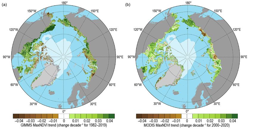
has dramatically impacted the Arctic system, most notably through the decline of sea ice extent and
thickness (Stroeve and Notz 2018; section 5d), decrease in snow cover (Cohen et al. 2020; section 5f),
loss of glacial ice (Hanna et al. 2020; section 5e), and increase in permafrost thaw (Biskaborn et al.
2019; section 5h). Arctic ecosystems are also highly sensitive to SAT trends and extreme temperature
events. For example, increased trends in terrestrial vegetation productivity and “greening” of the
Arctic tundra (section 5i) are closely linked with Arctic SAT warming (Myers-Smith et al. 2020).
   Intense Arctic temperature anomalies characterized 2020, as evidenced by the highest mean annual
terrestrial SAT anomaly since the start of the record in 1900 (Fig. 5.1). In northern Eurasia—beginning
in winter and continuing into spring and summer—the region’s persistent warm anomalies were
underscored by the late June heat wave in north-central Siberia (Overland and Wang 2021; sec-
tion 7g2). Sustained abnormal temperatures played a major role in the region’s vigorous wildfire
activity, as detailed in Sidebar 5.1, and the near-record summertime sea ice melt and warm sea
surface temperatures (SSTs) in the Laptev and Kara Seas (section 5c). Continued warm anomalies
atop the Barents and Kara Seas during autumn were associated with an upper-level ridge of high
pressure and an Arctic–midlatitude linkage event in December that brought widespread cold to
eastern Asia and the North Pacific.

1) Mean annual surface air temperature over the terrestrial Arctic
   In 2020, the Arctic annual mean SAT anomaly for terrestrial areas poleward of 60°N was 2.1°C
above the 1981–2010 average (Fig. 5.1). This marked the highest-observed SAT anomaly for the
terrestrial Arctic since at least 1900 and continued a pattern of seven consecutive years (and 8 of
the last 10 years) where SAT anomalies were more than 1°C higher than the 1981–2010 average.
Arctic warming has consistently outpaced global air temperature warming since 2000 (Fig. 5.1)
due to Arctic amplification, a phenomenon driven by multiple processes that operate on different
space and time scales (Overland et al. 2021). For example, seasonally variable mechanisms within
the Arctic, such as ice-albedo and cloud-radiative feedbacks, play a critical role in modifying air
temperatures (Cohen et al. 2020).

2) Seasonal air temperature patterns
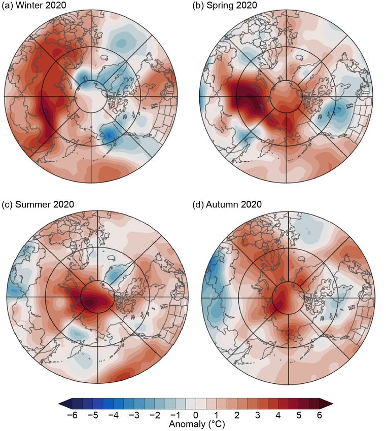
   Seasonal patterns of near-surface air temperature anomalies are shown for the winter (Janu-
ary–March), spring (April–June), summer (July–September), and autumn (October–December)
of 2020 (Fig. 5.2). These seasonal divisions roughly coincide with annual cycles of the Arctic
cryosphere, such as the onset of snowmelt and sea ice retreat during spring and their advances
during autumn.
   Winter was characterized by above-average temperatures stretching from eastern Europe to
central Siberia. An extensive area of +3° to +5°C air temperature anomalies occurred in north-
central Siberia (Fig. 5.2a). In contrast, areas extending eastward from Alaska to Greenland and
Svalbard showed abnormally cold air temperatures.
   Aligned with the highest winter Arctic Oscillation since records began in 1950 (Ballinger
et al. 2020), a zonal polar jet stream in 2020 yielded westerly winds, stormy weather, and relatively
mild northern Eurasian temperatures, while constraining colder-than-normal air over Alaska
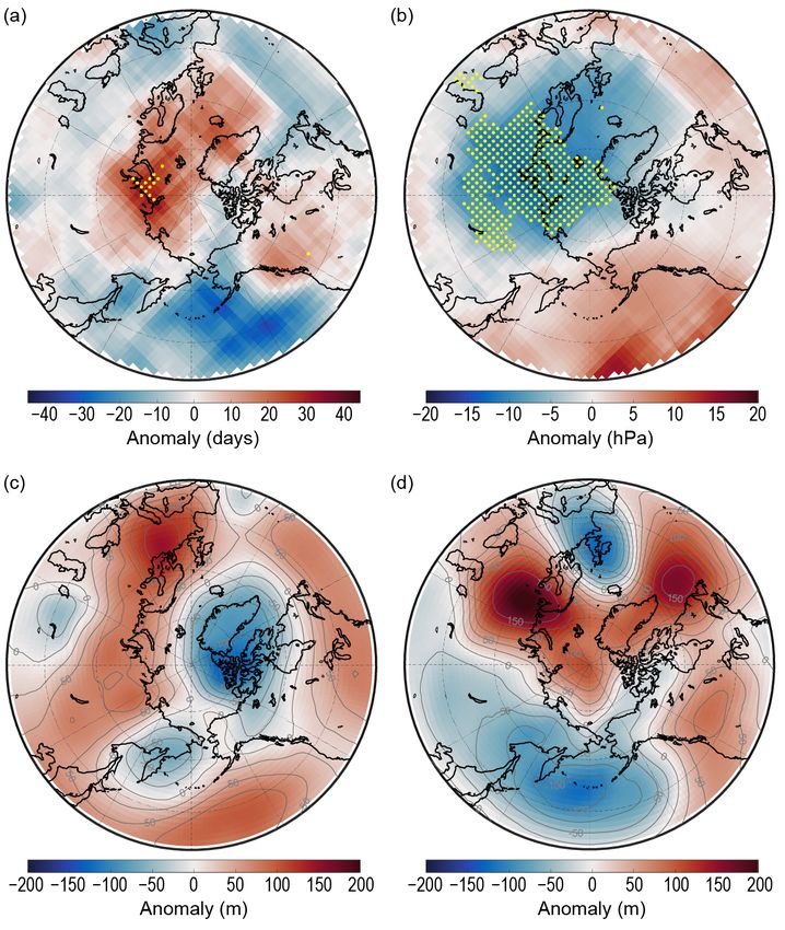
and portions of northern Canada (Fig. 5.3a). Frequent warm air intrusions into Eurasia were the
product of anomalous cyclone activity, with records set for above-average winter storm occurrence
and intensity over the Kara Sea and adjacent terrestrial areas (Figs. 5.4a,b). The anomalous atmo-
spheric circulation pattern and storminess impacted the Multidisciplinary drifting Observatory
for the Study of Arctic Climate (MOSAiC) Expedition, accelerating the icebreaker’s drift across the
central Arctic Ocean (approximately three times faster than Nansen’s historic Fram expedition
in the 1890s along a similar route; Shupe et al. 2020).

  AU G U S T 2 0 2 1 | S t a t e o f t h e C l i m a t e i n 2 0 2 0                      5. THE ARCTIC   S271
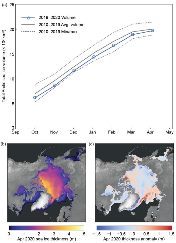
Fig. 5.2. Near-surface (925-hPa) seasonal air temperature anomalies (°C) for 2020 relative to the 1981–2010 base period for
(a) winter, (b) spring, (c) summer, and (d) autumn. The 925-hPa layer is used to emphasize large spatial temperature patterns,
rather than local surface features. (Source: NCEP/NCAR Reanalysis; Kalnay et al. 1996.)

Fig. 5.3. Atmospheric circulation patterns described by 500-hPa geopotential heights (GPH; m, blue contours) and 500-hPa
winds (red vectors) for (a) winter, (b) spring, (c) summer, and (d) autumn of 2020. The wind vector scale indicates winds
of 20 m s −1. (Source: NCEP/NCAR Reanalysis; Kalnay et al. 1996.)

            AU G U S T 2 0 2 1 | S t a t e o f t h e C l i m a t e i n 2 0 2 0                         5. THE ARCTIC    S272
Fig. 5.4. Arctic atmospheric extremes during 2020. (a) Winter cyclone count (number of days with cyclone activity) anomalies
and (b) cyclone intensity (minimum cyclone sea-level pressure [SLP], hPa) anomalies, relative to their respective 1981–2010
means. Yellow dots mark areas with the highest cyclone counts and the lowest seasonal average of minimum SLP within
cyclones, respectively, during winter 2020. (Source: ERA5 SLP data is from Hersbach et al. 2020, and the cyclone methods
are described in Webster et al. 2019.) (c) November and (d) December 500-hPa geopotential height anomalies (m), relative to
the 1981–2010 mean, provide a snapshot of the evolving autumn meridional jet stream pattern that caused a cold outbreak
over East Asia and the North Pacific in December 2020. (Source: ERA5 Reanalysis; Hersbach et al. 2020.)
Warm air temperature anomaly patterns covered much of the Arctic Ocean and coastal areas
during spring (Fig. 5.2b). At +5°C, north-central Siberian air temperature anomalies remained
far above normal. Late June was especially warm in the region, with a new record high station
SAT (since 1885) of 38°C observed at Verkhoyansk, Russia, on 20 June (Overland and Wang 2021).
Northward warm air advection fed by an upstream trough of low pressure over Europe (Fig. 5.3b)
led to record low Eurasian Arctic spring snow cover extent (section 5f) and a sea ice melt season
that began nearly 1 month earlier than the 1981–2010 mean in the Kara and Laptev Seas (http:
//nsidc.org/arcticseaicenews/2020/08/steep-decline-sputters-out/).
Summer air temperatures were relatively high for the central Arctic Ocean (4°–5°C above
average) and dissipated toward the terrestrial Arctic (Fig. 5.2c). Although warm anomalies over
north-central Siberia were not as intense as in winter and spring, the strength of the summertime
warm anomaly increased toward the coastal areas and into the Kara and Laptev Seas. The North
Atlantic Arctic, including Svalbard and Novaya Zemlya, also remained relatively warm through
summer. Despite below-normal air temperatures in the interior of the Greenland ice sheet, above-
average, but well below record, ice sheet melt ensued (section 5e). High-pressure ridging atop the
Siberian coast (Fig. 5.3c) steered warm air off the continent, across the Kara and Laptev Seas, and
toward the central Arctic, contributing to above-average SST anomalies and near-record sea ice
losses during late-summer (see sections 5c and 5d).
AU G U S T 2 0 2 1 | S t a t e o f t h e C l i m a t e i n 2 0 2 0 5. THE ARCTIC S273The Eurasian Arctic warm temperature anomaly continued into autumn, particularly along
the coast, highlighted by air temperatures ~4°C above normal in the Laptev Sea (Fig. 5.2d). Lo-
cal temperature anomaly maxima were also found over northern Greenland and the Chukchi
Sea, stretching into Chukotka and northern Alaska. Amidst a wavy polar jet stream, ridging and
southerly winds atop these areas supported above-average air temperatures (Fig. 5.3d).
An Arctic-midlatitude linkage event also emerged from this meridional jet stream configuration.
During November, a wide swath of upper-level high pressure developed over warm northern Eur-
asia (Fig. 5.4c). As with previous late autumn/early winter linkage cases documented by Overland
et al. (2021), the associated ridge continued to build into December across the Ural Mountains
and Barents-Kara Seas region, while a trough developed downstream that brought extreme cold
air to eastern Asia and the North Pacific (Fig. 5.4d).
Sidebar 5.1: Wildland fires in the high northern latitudes—A. YORK, U. S. BHATT, E. GARGULINSKI,
Z. GRABINSKI, P. JAIN, A. SOJA, R. THOMAN, S. VERAVERBEKE, AND R. ZIEL
Despite the low annual temperatures and short growing sea- regions are not temporally coincident (York et al. 2020). Figure
sons that characterize high northern latitudes (HNL), wildland SB5.1 shows cumulative satellite-derived fire detections across
fire is the dominant ecological disturbance within the region’s HNL from 2012 to 2020 from both the MODIS (Terra and Aqua)
boreal forest, the world’s largest terrestrial biome. The boreal and VIIRS SNPP instruments (Giglio et al. 2018; Schroeder
forest, also known as taiga, is the band of mostly coniferous et al. 2014). These data are the best available proxy for burned
trees stretching across the area north of the July 13°C isotherm area in the absence of a current satellite-derived high-latitude
in North America and Eurasia. Wildland fires also impact tundra burned area product.
regions bordering the taiga. This sidebar summarizes variability Within the Arctic Circle (>66.5°N), 2020 and 2019 stand
and trends in fire disturbance in HNL and outlines how climate out as extreme fire years that began unusually early in the
and subseasonal fire weather conditions in HNL influence the season (Fig. SB5.1a). The majority of the fire activity in these
extent of area burned. years was in the republic of Sakha in northeastern Siberia,
where fires burned primarily in montane ecosystems across
Variability and trends landscapes underlain by permafrost, with some fires burning
only about 11 km from the Chukchi Sea. The 2020 late winter,
Most area burned in HNL occurs during sporadic episodes of early spring, and summer temperature anomalies in this region
large fire growth, preceded by extended periods of drying and were remarkable (see section 5b), while precipitation anomalies
accompanied by anomalously hot and dry conditions (Flannigan were below normal, and snowmelt was the earliest recorded
et al. 2009). For example, 50% of the area burned in Alaska since 1967 (Thoman et al. 2020; section 5f). Satellite imagery
from 2002 to 2010 was consumed in just 36 days (Barrett et al. suggests that a large number of overwintering fires (Scholten
2016). Significant weather events, including prolonged warm et al. 2021) from 2019 jumpstarted the 2020 fire season in the
dry weather associated with blocking high-pressure systems region (Wheeling 2020). Including lower latitudes in fire detec-
(Hayasaka et al. 2016) and convective lightning storms (Veraver- tion analysis (Figs. SB5.1b,c) decreases the interannual variability
beke et al. 2017), are responsible for much of the variability in and alters the years of maximum fire detections, with 2019 as
HNL fire history. In both Alaska and Canada, lightning-caused a consistently exceptional fire year across HNL.
fires are responsible for the majority of area burned since at
least 1980 when reliable records began (AICC data; Hanes et al. Climatological influences
2019), in part because lightning-ignited fires are more likely to
be remote and subject to lower levels of suppression compared Climate is a dominant control of fire activity on interannual
to human-caused fires. and decadal scales. The relationship between climate and fire
Long-term data on burned area have been compiled for is strongly nonlinear in both boreal and tundra ecosystems,
Alaska and Canada but are more limited in Eurasia and Arctic with likelihood of fire occurrence within a 30-year period
tundra regions. These records show considerable interannual much higher where mean July temperatures exceed 13.4°C
variability and that large fire years in the most fire-prone HNL (Young et al. 2017). HNL fire regimes appear to be responding
AU G U S T 2 0 2 1 | S t a t e o f t h e C l i m a t e i n 2 0 2 0 5. THE ARCTIC S274to environmental changes associated with warming climate
(Hanes et al. 2019). Although highly variable, burned area has
increased over the past several decades in much, but not all, of
boreal North America (Hanes et al. 2019; York et al. 2020, and
references therein), and lightning ignitions have increased in
the same region (Veraverbeke et al. 2017; Bieniek et al. 2020).
Partain et al. (2016) found that anthropogenically-driven climate
change increased the likelihood of the extremely dry fuel condi-
tions seen in Alaska in 2015 by 34%–60%. South-central Alaska
experienced extreme late-season wildfire activity in 2019, ac-
companied by exceptionally dry summer conditions, observed
as the lowest cumulative June–August (ERA5) Standardized
Precipitation-Evapotranspiration Index (SPEI) since 1979, as
determined by reanalysis (ERA5; Bhatt et al. 2021). A separate
analysis of the 2019 Alaska fire season attributed Alaska’s
extreme fire activity in July to anthropogenic activity, primarily
through an increase in anthropogenic ignition and secondarily
through climate-induced biomass abundance (Yu et al. 2021).
Reflecting the importance of cumulative drying on fuelbed
flammability, the Canadian Forest Fire Danger Rating System
(CFFDRS) uses its Buildup Index (BUI; Wotton 2009) as a numeri-
cal rating of fuel availability for consumption. The BUI is derived
from daily accounting of surface air temperature, relative humid-
ity, and 24-hour rainfall totals. In boreal and arctic systems, BUI
reflects the flammability of duff fuels (i.e., accumulated layers
of partially decomposed moss and organic material) below the
surface (York et al. 2020). As BUI crosses significant thresholds,
fires can burn more intensely, spread more aggressively, and
pose more problems for suppression.
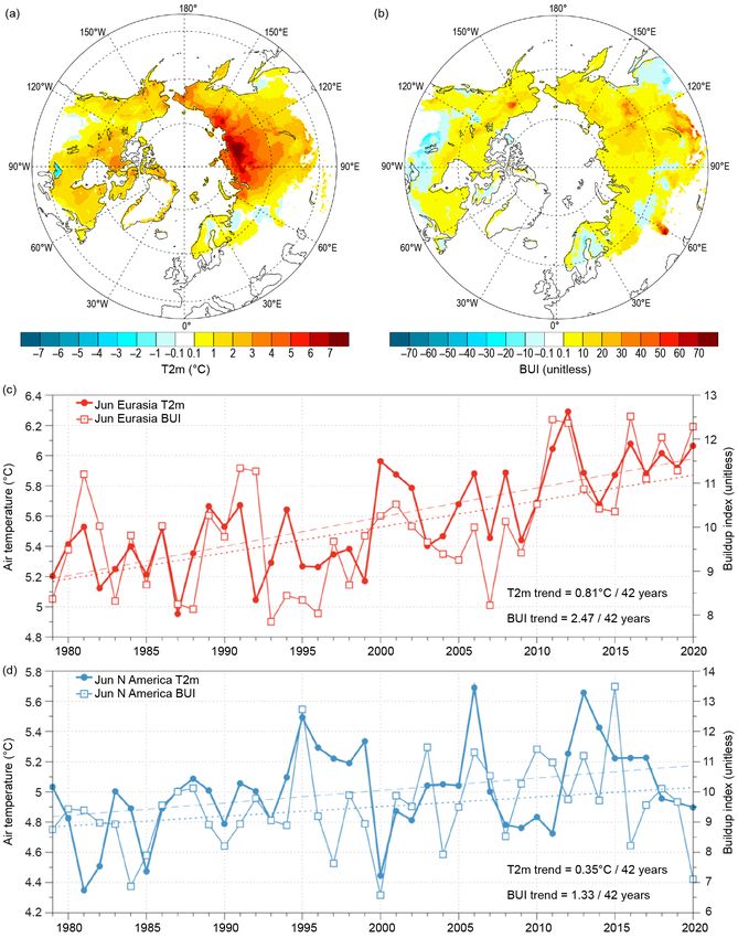
Figure SB5.2 shows total 2-m air temperature and BUI
changes and time series for boreal and tundra regions of
Eurasia and North America in June for the 42-year period of
record (1979–2020), calculated using ERA5 data (McElhinny et
al. 2020). Widespread increases in temperature and BUI in both
June and July (data not shown) and on both continents, particu-
larly Eurasia, suggest that conditions are becoming generally
more favorable for fire growth, with increases in cumulative
Fig. SB5.1. Cumulative satellite-derived active-fire detections drying and flammability likely to result in more intense burning,
across HNL for 2012–20 from both the 1-km MODIS (Terra more fire growth episodes, and greater consumption of fuels.
and Aqua) and 375-m VIIRS (Suomi NPP) instruments (Giglio Despite this general trend, considerable interannual variability
et al. 2018; Schroeder et al. 2014) for latitudes (a) >66.5°N
remains, exemplified by the near-record low June 2020 BUI in
(within the Arctic Circle), (b) >60°N, and (c) >50°N. The
North America (Fig. SB5.2d).
4 years with the highest detections are listed and shown in
color within each panel; within each year, colors are distinct.
Other years with relatively lower detections are shown in
gray. VIIRS detections, shown on the right axis, are consis-
tently an order of magnitude greater than MODIS detections
due to the higher resolution of the VIIRS instrument.
AU G U S T 2 0 2 1 | S t a t e o f t h e C l i m a t e i n 2 0 2 0 5. THE ARCTIC S275These observations of area burned, BUI, and temperature interacting factors, the resulting changes in HNL fire regimes
are consistent with analyses projecting significant increases will vary greatly over space and time. However, all evidence
(up to fourfold) in burned area in HNL ecosystems by the end indicates that northern ecosystems are increasingly vulnerable
of the twenty-first century under a range of climate change to wildland fire and its impacts.
scenarios (Young et al. 2017; Yue et al. 2015, and references (Text in this essay was drawn from a longer 2020 Arctic
therein). Because specific fire events depend on multiple Report Card essay [York et al. 2020].)
Fig. SB5.2. Change in Jun boreal and tundra (a) 2-m air temperature (T2m, in °C) and (b) BUI (unitless) from 1979 to 2020,
from ERA5 data. Jun T2m and BUI time series for boreal and tundra areas of (c) Eurasia and (d) North America. Linear-fit
trends over 1979–2020 (dashed for T2m and dotted for BUI) are significant for Eurasia at the 99% confidence level and
for North America at the 95% confidence level using a t-test.
AU G U S T 2 0 2 1 | S t a t e o f t h e C l i m a t e i n 2 0 2 0 5. THE ARCTIC S276c. Sea surface temperature —M.-L. Timmermans and Z. Labe Summer sea surface temperatures (SSTs) in the Arctic Ocean are driven mainly by the amount of incoming solar radiation absorbed by the sea surface. Solar warming of the Arctic surface ocean is influenced by the distribution of sea ice (with greater warming occurring in ice-free regions), cloud cover, and upper-ocean stratification. Discharge of relatively warm Arctic river waters can provide an additional source of heat to the surface of marginal seas. In the Barents and Chukchi Seas, there is also a contribution to ocean heat by the advection of warm waters from the North Atlantic and North Pacific Oceans, respectively. Arctic SST is an essential indicator of the role of the ice–albedo feedback mechanism in any given summer sea ice melt season. As the area of sea ice cover decreases, more incoming solar radiation is absorbed by the ocean and, in turn, the warmer ocean melts more sea ice. In ad- dition, higher SSTs are associated with delayed autumn freeze-up and increased ocean heat storage throughout the year. Marine ecosystems are influenced by SSTs, which affect the timing and development of primary and secondary production cycles, as well as available habitat for upper-trophic and temperature-sensitive species. Finally, with respect to carbon cycling, warmer SSTs are associated with reduced ocean uptake of CO2 from the atmosphere, and thus represent another positive feedback loop to a changing climate. The SST data presented here are a blend of in situ and satellite measurements from August 1982 to August 2020, taken from the monthly mean NOAA Optimum Interpolation (OI) SST Version 2 product (OISSTv2; Reynolds et al. 2002, 2007). Compared to purely in situ temperature measure- ments, the OISSTv2 product explains about 80% of the variance, with an overall cold bias via its tendency to underestimate SST by 0.02°C (Stroh et al. 2015). The OISSTv2 product uses a linear relationship with sea ice concentration to infer SST, with SST constrained to −1.8°C (the freezing point of seawater with a salinity of 33 g kg−1 at the sea surface) where ice concentration is 100% (Reynolds et al. 2007). Variations in freezing temperature as a result of variations in sea surface salinity (not accounted for in the algorithm) imply that OISSTv2 SSTs under sea ice can be too cool by up to 0.2°C, with the highest errors in the fresher surface waters of the Canada Basin. August mean SSTs provide the most appropriate representation of Arctic Ocean summer SSTs because they are not affected by the cooling and subsequent sea ice growth that typically takes place in the latter half of September. The period 1982−2010 is used as the climatological reference for the August mean. August 2020 mean SSTs ranged from 7° to 10°C in the southern Chukchi and Barents Seas to ap- proximately 1° to 3°C in the other Arctic Ocean marginal seas that are ice-free in August (Fig. 5.5a). Mean SSTs in August 2020 were consistent with sustained mean August SST warming trends from 1982 to 2020 over much of the Arctic Ocean, with statistically significant (at the 95% confidence interval) linear warming trends of up to +0.1°C yr−1 (Fig. 5.5b). Mean August SSTs for the entire Arctic (the Arctic Ocean and marginal seas north of 67°N) exhibit a linear warming trend of 0.03 ± 0.01°C yr−1. The cooling trend in mean August SSTs in the northern Barents Sea region remains a notable exception (see Timmermans et al. 2020) and remains under study. August 2020 mean SSTs were around 1°–3°C warmer than the 1982–2010 August mean over most of the Arctic Ocean’s marginal seas (Fig. 5.6a). The largest anomalies were observed in the Laptev and Kara Seas, with values up to +5.5°C (Fig. 5.6a). Conversely, similar to August 2019 conditions, the northern Barents Sea region was marked by anomalously cool SSTs in August 2020 with tem- peratures up to −1.5°C below the mean (Fig. 5.6), contributing further to the region’s long-term cooling trend. Relative to August 2019, August 2020 SSTs were up to 4°C cooler in the Chukchi and Beaufort Seas and a few degrees warmer overall in the Kara and Laptev Seas (Fig. 5.6). The strong interannual variability in spatial patterns of SST bear a close relationship to early summer sea ice concentrations (section 5d), with direct solar heating of the exposed surface waters likely driving an active ice–albedo feedback. AU G U S T 2 0 2 1 | S t a t e o f t h e C l i m a t e i n 2 0 2 0 5. THE ARCTIC S277
Fig. 5.5. (a) Mean sea surface temperature (SST; °C) in Aug 2020. White shading is the Aug 2020 mean sea ice extent, and
black contours indicate the 10°C SST isotherm. (b) Linear SST trend (°C yr−1) for Aug of each year from 1982 to 2020. The
trend is only shown for values that are statistically significant at the 95% confidence interval; the region is shaded gray
otherwise. White shading is the Aug 2020 mean sea ice extent, and the yellow line indicates the median ice edge for Aug
1982–2010. (Sources: SST data are from the NOAA OISSTv2; sea ice extent and ice edge data are from NOAA /NSIDC Climate
Data Record of Passive Microwave Sea Ice Concentration, Version 3; Peng et al. 2013; Meier et al. 2017.)

Fig. 5.6. Sea surface temperature (SST) anomalies (°C) in (a) Aug 2020 and (b) Aug 2019 relative to the Aug 1982–2010 mean.
The yellow line indicates the median ice edge for Aug 1982–2010 and white shading indicates the mean sea ice extent in
(a) Aug 2020 and (b) Aug 2019. The two regions marked by blue boxes indicate the Kara and Laptev Seas and relate to data
presented in Fig. 5.7. (Sources: SST data are from the NOAA OISSTv2; sea ice extent and ice-edge data are from NOAA /
NSIDC Climate Data Record of Passive Microwave Sea Ice Concentration, Version 3; Peng et al. 2013; Meier et al. 2017.)

             Anomalously warm SSTs in the Laptev and Kara Seas distinguished the August 2020 SST
          field. Overall, Kara Sea SSTs are becoming warmer in August with a linear warming trend over
          1982–2020 of 0.03 ± 0.01°C yr−1 (Fig. 5.7a). Although not statistically significant, Laptev Sea August
          mean SSTs also appear to be warming, with a linear trend of 0.02 ± 0.02°C yr−1 (Fig. 5.7b). The
          interplay between regional sea ice cover and solar absorption is evident in the low sea ice extents
          in August 2020 in these seas (Figs. 5.7c,d). Both regions also saw exceptionally low sea ice extents
          in July 2020, with Laptev Sea ice extent showing a record minimum for July. A similar pattern of
          SST anomalies in these regions extended through October 2020.

            AU G U S T 2 0 2 1 | S t a t e o f t h e C l i m a t e i n 2 0 2 0                      5. THE ARCTIC    S278
Fig. 5.7. Area-averaged sea surface temperature (SST) anomalies (°C) for Aug of each year (1982–2020) relative to the
1982–2010 Aug mean for the (a) Kara and (b) Laptev Sea regions, shown by blue boxes in Fig. 5.6. The dotted lines show
the linear SST anomaly trends over the period shown and numbers in the legends indicate the trends in °C yr−1 (with 95%
confidence intervals). Aug sea ice extents calculated over the (c) Kara and (d) Laptev Sea regions. (Sources: SST data are
from the NOAA OISSTv2; sea ice extent data are from the NSIDC Sea Ice Index, Version 3 (Fetterer et al. 2017) using a
regional mask introduced by Meier et al. 2007.)
d. Sea ice —W. Meier, D. Perovich, S. Farrell, C. Haas, S. Hendricks, L. Kaleschke, A. Petty, M. Tschudi, M. Webster,
D. Divine, S. Gerland, O. Pavlova, R. Ricker, X. Tian-Kunze, and K. Wood
1) Sea ice extent
Sea ice is an important component of the Arctic climate system. It reflects much of the incoming
solar energy due to its high albedo, or surface reflectivity, and acts as a physical barrier between
the ocean and atmosphere, limiting sensible and latent heat transfer. It also serves as an important
habitat for flora and fauna and it is a critical element of Indigenous culture (e.g., Gearheard et al.
2013). The long-term decline of Arctic sea ice extent from the now >40-year passive microwave
satellite record (1979 to present) has become one of the most iconic indicators of global climate
change. Here we use extent values from the National Snow and Ice Data Center (NSIDC) Sea Ice
Index (Fetterer et al. 2017). The Sea Ice Index trends and anomalies are generally consistent with
other extent products (e.g., the Ocean and Sea Ice Satellite Application Facility Climate Change
Initiative [OSI SAF CCI; Lavergne et al. 2019]).
March is the typical month of the maximum annual sea ice extent. In 2020, March extent was
14.79 million km 2 (Fig. 5.8a), with the daily annual maximum extent reached on 5 March, at
15.05 million km2 —the 11th-lowest daily maximum extent in the satellite record and the highest
AU G U S T 2 0 2 1 | S t a t e o f t h e C l i m a t e i n 2 0 2 0 5. THE ARCTIC S279Fig. 5.8. Sea ice extent maps for (a) Mar 2020 and (b) Sep 2020, with ice concentration >15% in white; the magenta contour
indicates the median extent for 1981–2010. (c) Percent anomaly of Mar (black) and Sep (red) extent for 1979–2020 relative
to the 1981–2010 average; the dashed lines indicate the linear trend.
since 2013. The somewhat higher maximum relative to recent years does not account for changes
in thickness (discussed below). Also, interannual variability is expected and does not negate
the multi-decadal decline in winter ice cover. Overall, March has experienced a significant long-
term (1979–2020) trend loss of −40,400 km2 ice extent per year (−2.6 % per decade relative to the
1981–2010 average; Fig. 5.8c).
The summer of 2020 was marked by an early retreat and late freeze-up of sea ice, particu-
larly in the Laptev Sea, leading to daily record lows in the region for much of mid-June through
mid-November. As a result, the Northern Sea Route along the Siberian coast was open for about
2.5 months (late July through mid-October), compared to less than a month that was typical in the
past. Another notable feature was an unconsolidated ice pack during late summer in the eastern
Arctic. This loose ice pack with broken ice floes separated by open water allowed the German
icebreaker RV Polarstern to easily reach the North Pole in August as part of the Multidisciplinary
Drifting Observatory for the Study of Arctic Climate (MOSAiC).
September is the month when the minimum annual sea ice extent occurs. In 2020, this av-
erage monthly ice extent was 3.92 million km 2 (Fig. 5.8b), the second lowest monthly extent
in the 42-year satellite record. On 15 September, the annual minimum Arctic sea ice extent of
3.74 million km2 was reached; this was also the second lowest on record. The September monthly
AU G U S T 2 0 2 1 | S t a t e o f t h e C l i m a t e i n 2 0 2 0 5. THE ARCTIC S280extent has been decreasing at an average rate of −82,700 km2 per year since 1979 (−13.1% per
decade relative to the 1981–2010 average; Fig. 5.8c).
2) Sea ice thickness and volume
While ice extent provides an easily quantifiable long-term metric of sea ice conditions, the ice
thickness and volume provide crucial additional insight into the state of the ice pack. In the past
decade, satellite altimetry has provided new estimates of thickness and volume over the entire
Arctic basin, beginning with the ESA CryoSat-2 radar altimeter, launched in 2010. The NASA Ice,
Cloud, and land Elevation 2 (ICESat-2) laser altimeter, launched in 2018, now provides a second,
independent source of thickness estimates.
Because radar altimeter measurements have higher relative errors for thin ice, a product has
been developed (Ricker et al. 2017) that combines CryoSat-2 data with estimates of thin ice from
the ESA Soil Moisture Ocean Salinity (SMOS) passive microwave radiometer. By combining thick-
ness with sea ice concentration, a seasonal record of sea ice volume can be produced.
The time series of CryoSat-2/SMOS sea ice volume, spanning October 2019 to April 2020, shows
that Northern Hemisphere (NH) sea ice volume grew by ~13,400 km3 during the winter 2019/20
season, but it was consistently below the 10-year average through the winter to the beginning
of the melt season in April (Figure 5.9a). A spatial map of thickness shows a typical pattern of
Fig. 5.9. (a) Time series of monthly Northern Hemisphere (NH) sea ice volume (× 10 3 km3) from CryoSat-2 /SMOS in winter
2019/20, spanning Oct 2019 to Apr 2020 (blue line with blue circles) compared to the 10-year average (solid gray line) for
winter 2010/11 through winter 2018/19, and the lowest (min) and highest (max) sea ice volume (dashed gray lines) for the
same 10 years; (b) CryoSat-2 /SMOS Apr 2020 sea ice thickness (m) and (c) thickness anomaly (m).
AU G U S T 2 0 2 1 | S t a t e o f t h e C l i m a t e i n 2 0 2 0 5. THE ARCTIC S281thicker ice toward Greenland and the Canadian Archipelago (Figure 5.9b). The below-average
(relative to the 2010–19 average) total sea ice volume in April 2020 was characterized by wide
areas of below-average ice thickness in the central Arctic basin and on the Russian continental
shelves (Figure 5.9c). However, ice thickness in April 2020 was above average in the Beaufort,
Barents, and Greenland Seas and north of Svalbard, likely caused by an increase in southward
advection of thicker multiyear sea ice.
The CryoSat-2/SMOS estimates are consistent with sea ice thickness estimates derived from
ICESat-2 release 3 freeboards (not shown), updated from Petty et al. (2020) using NESOSIM v1.1
(Petty et al. 2018) snow loading. These thickness estimates within an inner Arctic Ocean domain
also indicate a slightly thinner winter ice cover for much of 2019/20 compared to 2018/19, with an
April 2020 mean thickness of 2.0 ± 0.3 m (compared to 2.1 ± 0.3 m in April 2019).
3) Ice age
The age of sea ice is another key descriptor of the state of the sea ice cover, and older ice
tends to be thicker and thus more resilient to changes in short-term atmospheric and oceanic
variations compared to
younger (thinner) ice. Sea
ice age derived from La-
grangian tracking of ice
parcels (Tschudi et al.
2019, 2020) indicates a
significant loss of older
ice types. In the mid-
1980s, ice >3 years old
was the dominant type
of ice within the Arctic
Ocean region, compris-
ing roughly a third of the
ice in March (Fig. 5.10).
In March 2020, less than
10% of the Arctic Ocean
ice cover was older than
3 years. The dominant
ice type is now first-year
ice (0–1 years old), which
comprised about 70%
of the March 2020 Arc-
tic Ocean ice cover. The
median ice age dropped
from 2–3 years old in the
mid-1980s to less than
1 year old by 2020. The
total extent of the oldest
ice (>4 years old) declined
from 2.50 million km 2 in
March 1985 to 0.34 mil-
lion km2 in March 2020. Fig. 5.10. Late winter sea ice age coverage map for the week of (a) 12–18 Mar 1985
and (b) 12–18 Mar 2020. (c) Sea ice age percentage within the Arctic Ocean (purple
shaded region in bottom inset) for the week of 12–18 Mar from 1985 to 2020.
(Source: Data are from NSIDC and University of Colorado [Tschudi et al. 2019, 2020].)
AU G U S T 2 0 2 1 | S t a t e o f t h e C l i m a t e i n 2 0 2 0 5. THE ARCTIC S282You can also read


