Climate Resilient Māori Land
←
→
Page content transcription
If your browser does not render page correctly, please read the page content below
Climate Resilient Māori Land

Prepared for: Deep South National Science Challenge

June 2018
Climate Resilient Māori Land

Contract Report: LC3133

Shaun Awatere, Mike Marden
Manaaki Whenua – Landcare Research

Tui Warmenhoven, Pia Pohatu
He Oranga mō ngā Uri Tuku Iho Trust

Adam Daigneault
University of Maine

Juan Monge, Les Dowling, Duncan Harrison
SCION

Reviewed by: Approved for release by:
Utkur Djanibekov Suzie Greenhalgh
Economist Portfolio Leader – Supporting Business & Policy
Manaaki Whenua – Landcare Research Manaaki Whenua – Landcare Research

Disclaimer

This report has been prepared by Manaaki Whenua – Landcare Research for the Deep South National
Challenge. If used by other parties, no warranty or representation is given as to its accuracy and no liability is
accepted for loss or damage arising directly or indirectly from reliance on the information in it.

Crown copyright ©. This copyright work is licensed under the Creative Commons Attribution 4.0 International
licence. In essence, you are free to copy, distribute and adapt the work, as long as you attribute the work to
the Department of Conservation and abide by the other licence terms. To view a copy of this licence, visit
http://creativecommons.org/licenses/by/4.0/. Please note that the Department of Conservation’s logo may not
be used in any way which infringes any provision of the Flags, Emblems, and Names Protection Act 1981 or
would infringe such provision if the relevant use occurred within New Zealand. Attribution to the Department
of Conservation should be in written form and not by reproduction of any logo.


Contents

Summary ...................................................................................................................................................................... vi
1 Introduction .....................................................................................................................................................1
 1.1 Project Aim ............................................................................................................................................................ 1

2 Background ......................................................................................................................................................3
 2.1 Case Study Area: The Waiapu River Catchment ..................................................................................... 3

3 Methodology ...................................................................................................................................................7
 3.1 Kaupapa Māori assessment ............................................................................................................................ 9
 3.2 Identifying Afforestation Scenarios through Wānanga (Workshops) .......................................... 15
 3.3 Wānanga (Workshops).................................................................................................................................... 16
 3.4 Economic methods and models .................................................................................................................. 20

4 Results ............................................................................................................................................................. 29
 4.1 Kaupapa Māori Assessment .......................................................................................................................... 29
 4.2 Climate Change Modelling ............................................................................................................................ 33

5 Limitations of the study ............................................................................................................................ 44
6 Recommendations...................................................................................................................................... 45
 6.1 Governance Implications ................................................................................................................................ 45
 6.2 Policy Implications ............................................................................................................................................ 45
 6.3 Implications for Māori Landowners ........................................................................................................... 46
 6.4 Methodological Implications ........................................................................................................................ 46

7 Acknowledgements.................................................................................................................................... 48
8 References ..................................................................................................................................................... 49

Appendix 1 – SWOT Analysis ............................................................................................................................. 54
Appendix 2 – Supplementary material ........................................................................................................... 62

 ~ iii ~
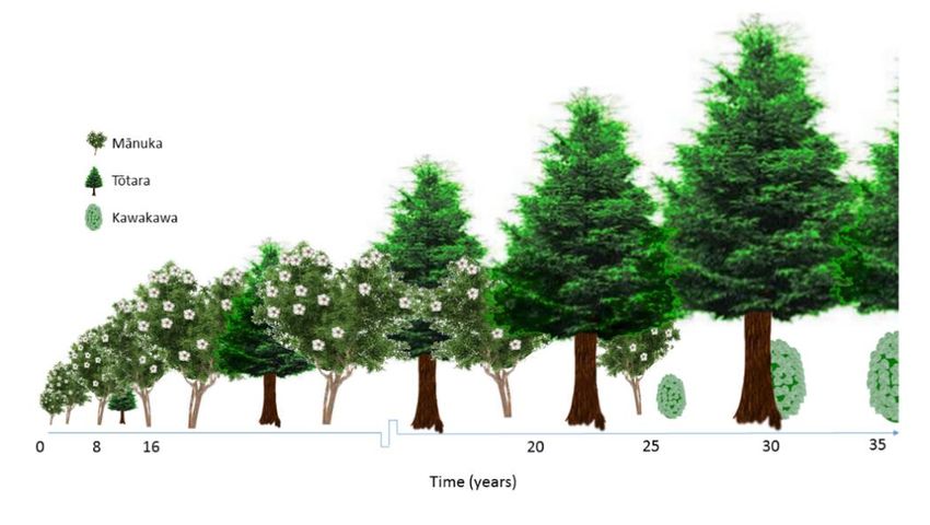
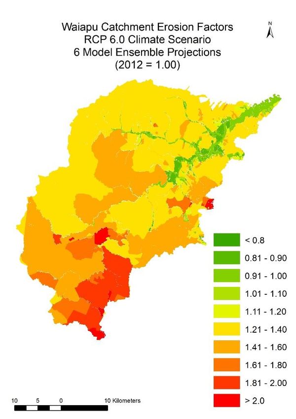
Table of Figures

Figure 1: Location of the Waiapu catchment in the North island of New Zealand. .................. 3
Figure 2: Research approach for the Climate Resilient Māori Land project. ................................ 8
Figure 3. Graphical representation of the flow of the coupled and complementary
approaches.......................................................................................................................................................... 20
Figure 4: Afforestation transitions through time. ................................................................................. 22
Figure 5: Triangular distribution function with respective parameters. ....................................... 23
Figure 6: Total baseline erosion from sheep-beef parcels in the Waiapu catchment: (A)
registered erosion in year 2015, and (B) forecasted erosion in year 2100 using the average
of a suite of 6 global circulation models and 4 representative concentration pathways. .... 27
Figure 7: Kaupapa Māori assessment for Ahikouka. ........................................................................... 30
Figure 8: Kaupapa Māori assessment for Tapuaeroa. ......................................................................... 31
Figure 9: Kaupapa Māori assessment for Tikapa. ................................................................................. 31
Figure 10: Total soil erosion from baseline by land use (model ensemble estimates) –
spatial. ................................................................................................................................................................... 34
Figure 11: Total soil erosion from baseline by land use (model ensemble estimates) –
tabular. .................................................................................................................................................................. 35
Figure 12: Areas suitable for forestry in the Waiapu catchment. ................................................... 36
Figure 13: Afforested areas of each parcel needed to reach various erosion-reduction
targets identified with NZFARM: (A) low, (B) medium, and (C) high. ........................................... 36
Figure 14: Uncertainty about forecasted total erosion in sheep-beef farms in the Waiapu
catchment under climate change: (A) through time and (B) in year 2100.................................. 37
Figure 15: Cumulative distributions functions of the net present values of the following
afforestation scenarios: (A) all under a 5% discount rate, (B) all under a 3% discount rate,
(C) all under a 1% discount rate, and (D) the mtk scenario under various discount rates. .. 39
Figure 16: Stochastic efficiency with respect to a function under a negative exponential
function for the net present value of three different afforestation scenarios and a 1%
discount rate....................................................................................................................................................... 39
Figure 17: Cumulative distribution function of the discounted public benefits obtained
from a low erosion-reduction scenario and respective ECFP investment (i.e. cost)................ 41
Figure 18: The expected benefits from avoided erosion necessary to compensate ECFP
investment with various certainty levels under climate change uncertainty for the following
scenarios: (A) low, (B) medium, (C) high, (D) all. ................................................................................... 42

 - iv -
List of Tables

Table 1: Wāhi Tapu/Taonga (significant sites) descriptors and variables.................................... 10
Table 2: Mahinga Kai (food-gathering areas) descriptors and variables ..................................... 10
Table 3: Ngā Otaota Māori (indigenous flora and fauna) descriptors and variables .............. 11
Table 4: Ngā Wai Tipuna (natural waterways) descriptors and variables .................................... 11
Table 5: Akoranga (education goals) descriptor and indicators ..................................................... 12
Table 6: Whanaungatanga (community development) descriptors and variables .................. 12
Table 7: Kia Mahi Ngātahi (partnerships) descriptors and variables ............................................. 12
Table 8: Whakapūmautanga (perpetuity) descriptors and variables ............................................ 13
Table 9: Mana Taurite (intergenerational equity) descriptors and variables.............................. 13
Table 10: Labour FTEs (labour full time equivalents) .......................................................................... 14
Table 11: Parameters for triangular distributions to represent uncertainty for the
profitability of the native tree species used as afforestation scenarios ....................................... 24
Table 12. Forecasted erosion, avoided erosion and afforestation under various erosion-
reduction targets in the Waiapu Catchment for all land uses and sheep-beef farms (S-B)
only ........................................................................................................................................................................ 27
Table 13: Average NPVs and standard deviations for the three afforestation scenarios
($/ha) ..................................................................................................................................................................... 37
Table 14: Total afforested areas and ECFP payments by erosion reduction scenario ............ 40

 -v-
Summary

Project and Client

The Climate Resilient Māori Land project is funded through the Deep South National
Science Challenge, Vision Mātauranga Programme.
• We address Theme 3 (Programme 2) of the Deep South NSC Research and Business
 Plan. Our aim is to help enhance the future prosperity of Māori by incorporating
 potential climate change impacts into land investment decisions and providing
 holistic approaches for managing climate-sensitive catchments.

Objectives

The objective of this research was to identify future land investment opportunities for the
Waiapu River catchment that accounted for climate change. These investment
opportunities focused on afforestation. Specifically, the research project:

• confirmed the core values, goals and objectives of the iwi/hapū in the catchment
• used the latest NIWA downscaled climate impacts layers to assess climate implications
 in the catchment under a range of future climate scenarios
• incorporated these climate impacts into the NZFARM model to assess the economic
 viability of afforestation opportunities under the different climate scenarios for the
 catchment
• assessed the bio-economic risk and uncertainty resulting from different climate
 scenarios and mitigation/adaptation strategies to estimate yield/price variability
 associated with the afforestation scenarios
• identified the impacts of climate change on Māori land to assist Māori landowners
 with catchment-level decisions on future investment opportunities
• demonstrated how this type of analysis can be benefit Māori organisations facing land
 investment decisions, both in the Waiapu River Catchment and other similar areas.

The research was conducted through a partnership between Manaaki Whenua Landcare
Research (LCR), SCION and the He Oranga mō ngā Uri Tuku Iho Trust.

Methods

A step-by-step process was used to discuss and evaluate afforestation scenarios utilising: a
kaupapa Māori assessment, a bio-physical assessment, and an economic assessment. The
process consisted of:

• Step 1: Landowner aspirations were identified through a series of wānanga in
 Ruatōrea.
• Step 2: Climate Change Modelling based on the baseline erosion rates from the New
 Zealand Empirical Erosion Model (NZEEM) were used to derive empirical distributions
 of climate change uncertainty.

 - vi -
• Step 3: Afforestation Scenarios were primarily identified through wānanga
 (workshops). Wānanga were mostly held on marae with site visits to the catchment.
• Step 4: Economic Modelling was undertaken using New Zealand Farm and Agriculture
 Regional Model (NZFARM) to assess the profitability of the afforestation scenarios.
 The afforestation scenarios included:
 i mānuka only
 ii mānuka and tōtara
 iii mānuka, tōtara, and kawakawa.
 NZFARM identified the optimal sheep and beef farming areas to afforest under 3
 erosion reduction targets – low, medium and high.
 Uncertainty analysis was undertaken to assess the effect on profitability from policy,
 market, climate change and profitability uncertainty. The efficiency of the Erosion
 Control Funding Programme (ECFP) was also assessed to help policymakers
 determine if ECFP would realise the expected public benefits of the programme
 where there was climate uncertainty.
• Step 5: Kaupapa Māori assessment of the afforestation scenarios for three Māori land
 parcels was undertaken using a Kaupapa Māori evaluation tool. The afforestation
 scenarios included the three scenarios outlined above and the afforestation 3 scenario
 plus horticultural options (hemp, olives, macadamias, lemons).
• Step 7: On-site Wānanga were used to discuss with landowners on-site climate
 mitigation approaches for the catchment. The mitigation approaches focused on
 retiring land from production and fencing with tree planting.

Results

• We estimated that if current land use practices continue, mean aggregate erosion
 could increase by 41% by the end of the century. These potential impacts, coupled
 with an already extremely high erosion rate, have driven national and local agencies
 to consider policy options and incentives to reduce erosion and their impacts to the
 economy and ecosystem. This has been primarily through afforestation programmes.
• Our analysis found that between 16,700 and 41,900 hectares of pasture would have to
 be afforested to achieve various erosion reduction targets, equivalent to 19–48% of
 the current area of sheep-beef farming in the catchment.
• We found that there were marked improvements in Kaitiakitanga (sustainable
 resource management) on the three land blocks with afforestation scenarios that
 include podocarps like tōtara. This was due to the long-term, intergenerational yields
 of these species. In comparison to the baseline scenario (sheep and beef farming),
 afforesting parts of the farms was less likely to impact negatively on Māori values as
 there was reduced sediment run-off into waterways.
• In terms of Manaakitanga (reciprocal obligations), the afforestation scenarios provide
 relatively more opportunities to improve connections between the farm, farm
 beneficiaries, and the local community than the existing land use.
• In terms of Whakatipu Rawa (growing the asset base), the benefits from investing in
 options, i.e. afforestation scenarios, that reduce erosion bodes well for future

 - vii -
generations. The long-term benefits of improved water quality and enhanced
 terrestrial ecosystems through riparian planting and management along with the
 reduced erosion are more likely to be realised by future generations.
• The mānuka-tōtara-kawakawa afforestation scenario, having the most uncertain
 profitability, became the preferred alternative only under a very low discount rate
 (1%). The relatively high revenues obtained far in the future are disadvantaged with
 higher discount rates. The profitability uncertainty comes from the uncertainty of
 future kawakawa and tōtara product prices. This scenario is plausible, however, for Te
 Tairāwhiti, as the iwi/hapū values like kaitiakitanga, manaakitanga, and whakatipu
 rawa reflect intergenerational aspirations.
• ECFP is unlikely to achieve the expected benefits as climatic uncertainty negatively
 impacts the flow of benefits. This may incentivise the Ministry for Primary Industries
 (MPI) and the Gisborne District Council (GDC) to re-evaluate the benefits (e.g.
 economic, social, environmental, etc.) from the programme in light of our estimated
 effects of climate change for the Waiapu catchment.

Limitations

The limitations of our assessment of investment opportunities for the Waiapu catchment
under climate change are:

• Land use: Land use data, while generally accurate at the catchment level, was not
 sufficiently refined for smaller scales. For instance, exotic forest was sometimes
 classified as indigenous forest, and vice versa. Therefore, the land use data for farm
 and block scale has to be refined with input from landowners and stakeholders.
• Lack of productivity data: The economic modelling was unable to incorporate any
 productivity effects of climate change on the tree/crop species included in the
 modelling. The assessment initially considered using radiata pine data as a surrogate
 for indigenous forest species but, due to the high variability in indigenous tree species
 and their responses to climate change compared to pine, we decided the pine results
 are not likely to be representative for indigenous forest. Future research ought to
 investigate the impacts of climate change on the productivity of indigenous tree
 species, particularly those species with economic and kaupapa Māori potential.
• Mean annualised returns: While the NPVs for the land use options on the flatter areas
 suggest that the crops are profitable, there is an establishment period for some crops,
 like apples and olives. This means, in the short term, there will be an initial financial
 burden for investors.

Recommendations

Some governance recommendations for the Waiapu catchment are:

• The findings and learnings from the Climate Resilient Māori Land project should be
 considered in future decision-making and policy development by Waiapu Kōkā
 Huhua in the catchment.

 - viii -
• Greater benefits for the Waiapu catchments could be achieved through greater
 coordination in the implementation of erosion management and mitigation actions,
 for example, between ECFP and Waiapu Kōkā Huhua.

Some policy recommendations are:

• To encourage the development of strategies, policies and processes by key
 governance and policy institutions in Te Tairāwhiti to support further afforestation in
 the Waiapu catchment, in line with the options assessed in this report.
• For the Ministry for Primary Industries and the Gisborne District Council to re-evaluate
 the likely benefits for the Waiapu catchment of the ECFP (as it is currently designed)
 so that it incorporates the impacts of climate change.
• To develop and implement a succession programme to the ECFP ensuring there is
 accountability for achieving the shared vision for Waiapu Kōkā Huhua on the part of
 the Crown.
• To continue supporting local and central government on several issues, e.g.
 governance training for Māori land institutions, capability development for local
 entrepreneurs/Māori landowners, and entrepreneurial efficacy for local
 entrepreneurs/Māori landowners. This support is required for the successful
 implementation of afforestation approaches to reduce the impacts of climate change.

Some recommendations for Māori landowners are:

• To further invest in the implementation of programmes that support capability
 development of Māori institutions governing Māori land, e.g. governance training.
• To further invest in developing the capability of whanau/hapū/iwi in the Waiapu
 catchment to realise the investment opportunities necessary to mitigate the effects of
 climate change in the catchment.
• To identify local champions and provide them with necessary policy and enterprise
 assistance to invest in opportunities like afforestation to help to mitigate the effects of
 and to adapt to climate change.

Some recommendations for working with Māori to address climate issues are:

• Kaupapa Māori assessments should be conducted alongside economic modelling to
 provide a fuller representation of aspirations and values from a Kaupapa Māori
 perspective.
• Future Kaupapa Māori assessments should include an assessment of wāhi
 tapu/taonga. However, this requires knowledge of wāhi tapu/taonga by local people.
 We recommend that when there are gaps in knowledge, wānanga are used to
 rediscover and share this knowledge.
• Assessments of the benefits from erosion control practices (e.g. afforestation) should
 consider using an ecosystem services evaluation and a Kaupapa Māori assessment to
 provide a more holistic and robust assessment of potential benefits.
• Future studies should include climate change projections to account for the possibility
 of public underinvestment. Estimating the benefits in the catchment under climate

 - ix -
change uncertainty not only supports investments to achieve specific erosion
 reduction targets but also supports identifying more beneficial investments.
• Landscape data generally provide reliable and accurate data for landscape-level
 analysis but needs to be refined with input from landowners and stakeholders when
 assessing afforestation scenarios at a farm or block scale.
• Future research is required to explore the impact of temperature changes on a wider
 range of tree/crop species.

 -x-
1 Introduction

Climate change is expected to have major implications for future and existing investment
in New Zealand. Māori not only have long-term interests in the land they own and/or
manage but are also heavily invested in primary industries, which are exposed to a range
of vulnerabilities from both present and future projected climatic conditions (Reisinger et
al. 2014). More than 60% of Māori-owned land is steep and hilly, making it highly
susceptible to damage from high intensity rain events and erosion. Conversely, their land
on the plains is susceptible to flooding and sedimentation (Harmsworth et al. 2006; King
et al. 2010). While many Māori organisations have the institutional capacity to manage
their land and adapt to climate change (Reisinger et al. 2014), information and approaches
to understand the implications of climate change for land investment decisions are often
not available or have not been clearly demonstrated. To enable more enduring decisions
by Māori organisations, a clearer understanding is needed of climate change impacts and
their implications for investment decisions. This will improve the ability of Māori
landowners to mitigate or avoid the potential consequences of climate change, thereby
improving the resilience of their investments and the prosperity of their communities.

1.1 Project aim

We address Theme 3 (Programme 2) of the Deep South NSC Research and Business Plan.
Our aim is to help enhance the future prosperity of Māori by incorporating potential
climate change impacts into land investment decisions and providing holistic approaches
for managing climate-sensitive catchments.

This proposed research encompasses both developed and undeveloped Māori land as it
strives to improve the resilience of land management decisions and investment in the face
of changing climate. There has already been significant investment, and new investments
will be made in the future, on Māori land that is likely to be adversely impacted by climate
change (or potentially benefit from it). It is vital to ensure existing and future ventures
consider these impacts and benefits.

The East Coast of New Zealand’s North Island is already suffering from the repercussions
of previous land management decisions that have led, in particular, to high rates of
erosion. This is likely to be exacerbated by climate change through extreme rain events
generating higher erosion losses, and drought events being more profoundly felt due to
degraded soil resources. The Waiapu catchment has been the focus of previous studies
(Harmsworth et al. 2002; Funk et al. 2014; Warmenhoven et al. 2014) as well as Ministry for
Primary Industries and Gisborne District Council initiatives such as the Erosion Control
Funding Programme (Ministry of Primary Industries 2015a), Restoring the Waiapu
Catchment: “Healthy land, healthy rivers, healthy people” (Warmenhoven et al. 2014) and
Sustainable Hill Country Projects (Ministry of Primary Industries 2015b).

This project supports these previous initiatives, in particular the aspirations for restoring
the Waiapu Catchment (Ngāti Porou), to incorporate climate change implications into the
investment decisions by Māori landowners.

 -1-
The current project will explore alternative forestry under various climate change scenarios
and extend the promotion of indigenous forestry and alternative forestry for erosion
susceptible land in the Waiapu catchment.

1.1.1 Objectives

The objective of this research was to identify future land investment opportunities for the
Waiapu River catchment that accounted for climate change. These investment
opportunities focused on afforestation. Specifically, the research project:

• confirmed the core values, goals and objectives of the iwi/hapū in the catchment
• used the latest NIWA downscaled climate impacts layers to assess climate implications
 in the catchment under a range of future climate scenarios
• incorporated these climate impacts into the NZFARM model to assess the economic
 viability of afforestation opportunities under the different climate scenarios for the
 catchment
• assessed the bio-economic risk and uncertainty resulting from different climate
 scenarios and mitigation/adaptation strategies to estimate yield/price variability
 associated with the afforestation scenarios
• identified the impacts of climate change on Māori land to assist Māori landowners
 with catchment-level decisions on future investment opportunities
• demonstrated how this type of analysis can be benefit Māori organisations facing land
 investment decisions, both in the Waiapu River Catchment and other similar areas.
The research was conducted through a Manaaki Whenua Landcare Research (LCR), SCION
and the He Oranga mō ngā Uri Tuku Iho Trust partnership.

 -2-
2 Background

2.1 Case study area: The Waiapu River Catchment

The current study took place in the East Coast region of the North island of New Zealand,
namely the Waiapu catchment in the Gisborne district (Fig. 1). The Waiapu catchment
covers an area of 175,800 ha in the north of the Gisborne–East Coast region near East
Cape. It is centred on the township of Ruatōrea, with a population inside the catchment
boundaries of about 1500. The highest point in the catchment is the culturally significant
Maunga Hikurangi (Mount) at 1752 m a.s.l., flanked on the east and north-east by Aorangi
(1272 m), Wharekia (965 m), and Taitai (677 m), and on the north-west by Whanakao
(1618 m). In the middle to upper part of the catchment, hill country rises steeply from
numerous incised valleys to heights between 100 and 600 metres, bounded in the west by
the Raukumara ranges, between 500 and 1500 metres. The Waiapu River is formed by the
joining of the Mata and Tapuaeroa Rivers, which originate in the headwaters of the steep
Raukumara range. The rivers flow east and northeast to the Pacific Ocean. The Waiapu
catchment shares the southwest catchment divide with the Waipaoa River, which runs
southwards towards Gisborne. The Waiapu River provides the lifeblood of Ngāti Porou,
the primary iwi of the catchment, and is of great cultural and spiritual significance to them.

The Waiapu Catchment is a relevant case study for four major reasons: (1) Current Global
Climate Models and Earth System Models often poorly represent some physical processes
in the region; (2) the East Coast is one of the most erosion-prone regions in New Zealand;
(3) the existence of two environmental policies rewarding regulating services from forests
(carbon sequestration payments and erosion mitigation subsidies); and (4) the region’s
predominant indigenous Māori population and the growing preference of native forestry
products informed by intrinsic and holistic shared values such as mauri (life-force). These
four points are expanded on below.

Figure 1: Location of the Waiapu catchment in the North island of New Zealand.

 -3-
There is currently a National Science Challenge in New Zealand to properly model the
climate processes in the Southern Ocean and Antarctica, namely the “Deep South” region.1
The core objective of the Challenge is to assemble the first New Zealand Earth System
Model (NZESM) to properly model physical processes of atmospheric and oceanic
circulation in the region. However, the relatively recent launch of the Challenge precludes
the use of the potentially more refined results from the NZESM. Hence, such lack of data
presents an opportunity to use sparse GCM-downscaled spatial data from previous
projects (Tait et al. 2016) and statistical techniques that do not require large datasets to fit
a probability distribution function, namely the use of non-parametric empirical distribution
functions.

In 1840, before deforestation of the native forest, at least 80% of the Waiapu catchment
was covered with mainly podocarp broadleaf and beech. The ecosystem was healthy and
vibrant with a flourishing mauri (life force). Deforestation and the establishment of
pastoral farming by European settlers started about 1890 and initiated a phase of greatly
increased erosion and sediment transfer. The main period of deforestation and burning
was between 1890 and 1920. As a consequence, the present-day catchment exhibits an
extensive and serious erosion problem due, in part, to the number of subsequent storm
events and floods in 1916, 1918, 1938, and Cyclone Bola in 1988 (Harmsworth et al. 2002).
Nowadays, the East Coast is one of the most erosion-prone regions of New Zealand and in
the world (Cumberland et al. 1980; Glade et al. 2006). Frequent and extensive flooding
occurs throughout the catchment but has always had a particularly devastating effect on
the highly productive floodplains and low terraces in the lower parts of the catchment,
from Ruatōrea to the Waiapu river mouth.

Planting of exotic forest to control erosion began in the late 1960s. In the headwaters of
the most highly eroded subcatchment, the Tapuaeroa, conversion of eroded pasture to
exotic forest began in 1969. Due to increasing costs for on-site mitigation strategies, the
New Zealand government acquired large areas of farmland, mainly located in the
headwaters of the three major river catchments in this region, and successively reforested
these areas during the 1960s to late 1980s (Marden et al. 2011). Major storm events in the
1980s caused massive damage and initiated new gullies, particularly on pastoral farm land.
In response to that, the New Zealand government initiated the East Coast Forestry Project
to provide grants for establishing an effective tree cover on erosion-prone farm land.
These catchments have moved towards a sustainable land use regime in the last 30 years,
with increased protection of native forest and widespread and targeted exotic forestry
planting (i.e. Pinus radiata) on erosion-prone land. Exotic forest now accounts for about
26% of the Waiapu catchment area, ~37% remains in pasture, of which about half is
located on marginal steep hill country and is regarded as unsustainable. Native forest
(Lowland and Highland beech, broadleaved and some podocarp) still makes up about 21%
of the catchment and is mostly restricted to the steep mountainous headwaters with

1
 http://www.deepsouthchallenge.co.nz/

 -4-
smaller patches of remnant native vegetation occurring near lowland rivers. Shrublands
comprising mainly kānuka (Kunzea ericoides) and mānuka (Leptospermum scoparium)
cover about 12% of the middle and lower parts of the catchment. Much of the lower part
of the catchment consists of alluvial floodplain and terraces where the soils are considered
to be some of the most versatile (LUC Class II and III) in New Zealand and are currently
utilised for pastoral farming and fodder cropping.

Many exotic forests are presently being felled, and there is concern among the community
and some stakeholders that the projected increase in the rate of clear-felling will again
lead to high levels of erosion and sediment transfer. Most exotic forests are planted and
felled to the edge of rivers and streams which after the completion of harvesting have
little remaining riparian protection. Some selective clear-felling of native forest still occurs
on both private land and in the DOC estate. Any clearing of scrub on erosion-prone land
will also lead to greater erosion, increased sediment transfer and flooding. Most areas of
scrub are not fenced and remain open to livestock and feral animals (Harmsworth et al.
2002).

The vulnerability of the land to erosion has negatively impacted the productivity potential
of the land – and hence its profitability – and the future economic growth prospects of the
region. These impacts, coupled with comparatively lower socio-economic statistics,
including some of the lowest household incomes in New Zealand, and the greater
likelihood of being unemployed (Smith et al. 2017), present additional challenges to
improving the productivity and economic well-being of this catchment. The Waiapu
catchment also comprises relatively large areas of Māori land in multiple ownership. While
most of this area is used for pastoral farming and forestry, large tracts of land remain
undeveloped and covered in shrubland and indigenous forest. About 70% of farms are in
hill country, thus many Māori are involved in pastoral farming, mainly beef and sheep, and
grow maize and other fodder crops on and adjacent to floodplains; most Māori, however,
live near or on the floodplains.

The degradation of Māori environmental and social values can be attributed to forest
clearance over a century ago and to the impacts of repeated storm and flood events on
the landscape since then (Warmenhoven et al. 2014). Because of these events, the lives,
economic status, and general well-being of people living in the Waiapu area have been
greatly affected. Māori have had to adjust to this rapid transformation of their landscape
and adapt to an environment with greatly heightened erosion and flooding risks that
continue to cause the loss of large tracts of cultural resources, such as native forest that
comprises culturally significant flora and fauna, ongoing damage to utilities including
power and the road infrastructure, as well as damage to housing and loss of productive
farmland. The highly degraded state of the Waiapu Awa is linked to the loss and decline of
Mātauranga Māori (indigenous knowledge) and the mauri (life force) of the catchment.
The poor health of the Waiapu River catchment is therefore of great concern.

Steps to address the loss of well-being or mauri is being addressed by Waiapu Kōkā
Huhua – Waiapu Restoration Programme, a collaborative programme between the
Ministry for Primary Industries, Te Rūnanganui o Ngāti Porou (TRONPnui) (the tribal
authority representing the primary iwi in the Waiapu river catchment – Ngāti Porou), and
the Gisborne District Council (GDC). The programme is a result of the Waiapu Accord, a

 -5-
post-settlement, co-governance partnership between Ngāti Porou and Crown entities. The
vision for the 100-year programme is: "Healthy land, healthy rivers, healthy people – Ko te
mana: Ko te Hauora o te whenua, Ko te Hauora o nga awa; Ko te Hauora o te iwi". The
programme aims to treat erosion, stop greater physical damage to the catchment, and
bring social and economic gains to iwi and landowners.

These inter-generational aspirations inform Ngāti Porou’s preferences for productive
forest systems consisting of native tree species, rather than the predominant exotic
species in the region, namely radiata pine (Pinus radiata D. Don). Native species with the
potential to contribute to productive planted forest systems analysed here are mānuka
(Leptospermum scoparium), tōtara (Podocarpus tōtara) and kawakawa (Piper excelsum).
These species have been chosen for this study because of their high cultural significance
and potential high profitability, which is conditioned on the uncertain niche markets where
their products would be traded due to their uniqueness.

The Waiapu River catchment provides an ideal location for this study due to the existence
of environmental policies incentivising two important regulating services from forestry:
climate change mitigation (i.e. carbon sequestration) and erosion control. The New
Zealand Emissions Trading Scheme (NZ ETS) is a domestic national policy implemented to
meet the nation’s international climate change obligations. Through the NZ ETS a price is
assigned to a tonne of CO2e sequestered, or a New Zealand Unit (NZU), creating an
incentive to plant trees (Ministry for the Environment 2017). The ECFP is a regional
initiative, led by the Gisborne District Council and the Ministry for Primary Industries, that
grants landowners funding to control erosion on the worst eroding or erosion-prone land
in the district. Eligible treatments include the establishment of indigenous forestry in
retired grazing land (Ministry for Primary Industries 2017b).

Due to their design and the effects of climate change, the uncertain benefits obtained
from such policies have important implications for landowners and governments alike.
Previous modifications of the NZ ETS resulted in highly uncertain carbon price signals that
affected landowners’ trust and, hence, enrolment numbers.2 The ECFP has been designed
as an incentive mechanism (i.e. early lump-sum payments) to promote land use change to
control for erosion. However, due to the uncertain erosion forecasts under climate change,
it would be worthwhile to assess the effectiveness of such policy in reaching the expected
public benefits.

2
 A modification of the NZ ETS back in 2009 permitted the surrendering of international Kyoto carbon units.
Due to an oversupply of international units coupled with a low demand from the EU, such modification
resulted in a drastic NZU drop to a record low of $2/NZU in 2013. See Richter & Chambers (2014).

 -6-
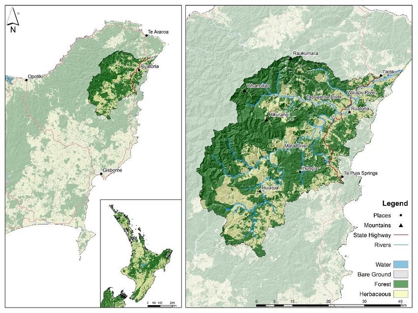
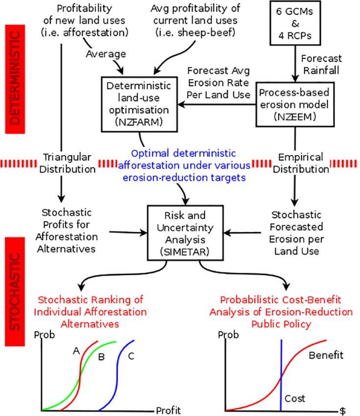
3 Methodology

We recognise that a collaborative research approach provides more useful outcomes for
Māori than a standard desktop analysis or the rollout of a spreadsheet or GIS application.
Interacting with farm managers on the ground using kaupapa Māori research practices of
whanaungatanga and kanohi ki te kanohi along with collaborative workshops were
essential parts of our research approach. A collaborative process was established to work
closely with selected Māori land owners in the Waiapu Catchment, Ruatōrea. A series of
hui were carried out to identify, consider, and evaluate investment scenarios like
afforestation. Several project meetings (4) and site visits (2) with the trustees and farm
management took place at Taumata o Mihi Marae (Rauru), Ruatōrea. The meetings, a
mixture of informal conversations with technical experts and formal presentations along
with semi-structured questions, helped provide direction to the research team and offered
an opportunity for the trustees/management to provide input into the research process.

A step-by-step process was used to discuss and evaluate afforestation scenarios utilising: a
kaupapa Māori assessment, a bio-physical assessment and an economic assessment (see
Figure 2). The process consisted of:

• Step 1: Landowner aspirations – A series of wānanga in Ruatōrea were carried out to
 identify landowner aspirations for the catchment. The research team met with owners
 of Māori land in the Waiapu catchment and listened to the landowner aspirations for
 their whenua.
• Step 2: Climate Change Modelling – based on baseline erosion rates developed with
 the New Zealand Empirical Erosion Model (NZEEM) were used to derive empirical
 distributions of climate change. In this study, we estimated annual erosion for all 286
 sheep-beef land parcels in the catchment and a combination of 6 Global Climate
 Change Models (GCM) for the 4 Representative Concentration Pathways (RCP)
 scenarios for year 2100.3
• Step 3: Afforestation Scenarios were primarily identified through wānanga
 (workshops). Wānanga were mostly held on marae with site visits to the catchment.
 Identification of tree/shrub species by project team (indigenous and non-indigenous):
 the project team identified a list of potential tree/shrub species and combinations for
 afforestation scenarios (20–30 plus), drawing on the existing work by Landcare
 Research and SCION. The afforestation scenarios were reviewed by Ngāti Porou Māori
 landowners during the first wānanga. The project team refined the list of potential
 tree/shrub species and combinations to three indigenous afforestation scenarios for
 economic modelling and Kaupapa Māori assessment. The afforestation scenarios were
 validated by Māori land owners at the second wānanga.

3
 The 6 best-performing GCMs for the New Zealand region were selected, based on comparisons with
observations over the historical data period of the models, namely the HadGEM2-ES (UK), CESM1-CAM5
(USA), NorESM1-M (Norway), GFDL-CM3 (USA), GISS-E2-R (USA) and BCC-CSM1.1 (China). See Tait et al.
(2016).

 -7-
• Step 4: Economic Modelling was undertaken using New Zealand Farm and Agriculture
 Regional Model (NZFARM) to assess profitability of the afforestation scenarios.
 NZFARM is an economic land-use model that has been used to explore the impacts of
 water and climate policy and resource constraints, climate impacts, and opportunities
 to improve land-based productivity and profitability in other catchments in New
 Zealand. A simplified list of afforestation scenarios was selected for this step. The
 afforestation scenarios included:
 (i) mānuka only: chosen as a resilient crop suitable for growing conditions on
 the East Coast of New Zealand, providing revenues from the sale of honey
 (ii) mānuka and tōtara: mānuka was used as a nurse crop providing shelter to
 aid in the establishment of tōtara, using the latter as a long-term high-value
 alternative
 (iii) mānuka, tōtara, and kawakawa: similar to the previous scenario with the
 addition of kawakawa as a high-value understory crop. Kawakawa is of high
 cultural value and produces a specialized product for use in pharmaceuticals.
• Step 5: Kaupapa Māori assessment of the afforestation scenarios for three Māori land
 parcels was carried out using a Kaupapa Māori evaluation tool. A simplified list of
 afforestation scenarios was selected for this step. The afforestation scenarios included:
 afforestation 1 (mānuka only), afforestation 2 (mānuka and tōtara), afforestation 3
 (mānuka, tōtara, and kawakawa), afforestation 3 plus horticultural options (hemp,
 olives, macadamias, lemons). Using the methodology described below, the benefits
 from each afforestation scenario were ranked by the project team.
• Step 6: On-site Wānanga were used to discuss on-site climate mitigation approaches
 for the catchment. The mitigation approaches focused on, retiring land from
 production and fencing with tree planting. The training also included the practical
 steps required to carry out these types of mitigation approaches.

Figure 2: Research approach for the Climate Resilient Māori Land project.

 -8-
Pluralistic methods from quantitative economic analysis to qualitative wānanga were
utilised for this study. Economic modelling was used to assess the returns from a diverse
group of afforestation scenarios; the GCS model was downscaled for the Waiapu
catchment with a focus on erosion; and a Kaupapa Māori approach was used to assess the
benefits of each afforestation scenario from a Māori perspective. A description of the
Kaupapa Māori assessment is provided first, followed by the econometric methods and
models (NZFARM and Uncertainty) and finally a description of the process
(wānanga/workshops) for eliciting the preferred afforestation scenario by Māori
landowners in the Waiapu catchment.

3.1 Kaupapa Māori assessment

Mātauranga Māori can inform all aspects of policy and strategic planning for collective
assets. It is essential to create a robust, consistent, and replicable process to support the
engagement of iwi/hapū/beneficiaries in the management, decision-making, planning,
and policy development for collective assets. This ensures tangata whenua values and
interests are identified and reflected in planning and management of collective assets
from the outcome setting through to the goal setting, decision-making and evaluation
stages.

Māori values, derived from the traditional belief system, are part of the wider Māori
knowledge system, and can be defined as instruments through which Māori make sense
of, experience, and interpret the environment. Māori values can be represented in many
forms:

• in the environment as places or sites of significance: the basis for recognising Māori
 treasures (taonga), such as iconic flora and fauna species, significant biodiversity,
 mahinga kai and environmental issues
• in the language: through relationships between people or organisations; and the
 intrinsic cultural basis for controlling or modifying human behaviour, forming the
 principles and ethics by which we live and advance.

Using a kaupapa Māori assessment, each afforestation scenario was assessed from the
perspective of Ngā Pou Herenga (Core Values and Principles). These core values and
principles were identified by Awatere (Awatere et al. 2014):

• Kaitiakitanga – Māori sustainable resource management (not the same as
 guardianship as there is an element of active use based on whakapapa and the ability
 of securing an access and use right to the resource)
• Manaakitanga – reflects reciprocity of actions to the environment, the wider
 community, to iwi/hapū, and other people
• Whakatipu Rawa – concerned with growing the asset base, retention of Māori owned
 resources and effective use of these resources for beneficiaries and future
 generations.

These principles align with but are not proxies for economic, social, and environmental
well-being. They represent alternative ideologies for well-being, are used in natural

 -9-
resource management planning, and have been adapted here for collective asset
management (Tāmaki Regional Mana Whenua Forum 2007; Jefferies et al. 2009; Awatere
et al. 2012, 2013; Harmsworth et al. 2013)). There is potential for including wairuatanga
(spiritual well-being), where narrative descriptions are provided alongside the modelling
to provide further explanation or to support the outcomes from the modelling.

A kaupapa Māori assessment can be used to measure and assess the benefits of
afforestation scenarios. An assessment tool helps the assessor(s) of any investment (e.g.
trustees of a Māori land incorporation or trust) evaluate any investment or activity against
Ngā Pou Herenga (Core Values and Principles). These core Māori values, principles, and
criteria/indicators for measurement are described next along with a statement for how
they could assess an investment:

 He Pou Herenga (Guiding Principle): Kaitiakitanga

The attributes for Kaitiakitanga are:

• Wāhi tapu/taonga: The mauri of culturally significant sites. How well does the
 investment enhance the mauri of culturally significant sites? and
• Mahinga kai: The mauri (life-force principle) of food-gathering areas. How well does
 the investment provide for traditional food-gathering areas?
• Ngā Otaota Māori: The mauri of culturally significant plants. How well does the
 investment enhance the mauri of native flora and fauna?
• Ngā Wai Tipuna: The mauri of culturally significant waterways. How well does the
 investment enhance the mauri of significant waterways?

Tables 1–4 below provide a description of the indicators and measures for Kaitiakitanga.

Table 1: Wāhi Tapu/Taonga (significant sites) descriptors and variables

Wāhi Tapu/Taonga (significant sites): Does the investment protect and enhance significant sites?

PAI RAWA 4 All wāhi tapu/taonga are protected and enhanced

 PAI 3 Most wāhi tapu/taonga are protected and enhanced

ĀHUA PAI 2 Some wāhi tapu/taonga are protected and enhanced

 PŌHARA 1 Few wāhi tapu/taonga are protected and enhanced

 AUE 0 No wāhi tapu/taonga are protected and enhanced

Table 2: Mahinga Kai (food-gathering areas) descriptors and variables

Mahinga Kai (food-gathering areas): Does the investment improve the well-being of food-gathering
areas through restoration and enhancement activities?

PAI RAWA 4 All mahinga kai are protected and enhanced

 PAI 3 Most mahinga kai are protected and enhanced

ĀHUA PAI 2 Some mahinga kai are protected and enhanced

 PŌHARA 1 Few mahinga kai are protected and enhanced

 AUE 0 No mahinga kai are protected and enhanced

 - 10 -
Table 3: Ngā Otaota Māori (indigenous flora and fauna) descriptors and variables

Ngā Otaota Māori (indigenous flora and fauna): Does the investment protect and/or enhance native
flora, fauna, habitats, ecosystems, and biodiversity?

PAI RAWA 4 Full protection of ecosystems and enhancement of biodiversity; landscaping and riparian zones
 plant all native plants

 PAI 3 Moderate protection ecosystems and enhancement biodiversity, landscaping and riparian
 zones plant mostly native plants

ĀHUA PAI 2 Occasional protection of ecosystems and enhancement of biodiversity, landscaping and
 riparian zones plant some native plants

 PŌHARA 1 Few protections of ecosystems and enhancement of biodiversity, landscaping and riparian
 zones plant few native plants

 AUE 0 No protection of ecosystems and enhancement of biodiversity, landscaping and riparian zones
 plant no native plants

Table 4: Ngā Wai Tipuna (natural waterways) descriptors and variables

Ngā Wai Tipuna (natural waterways): Does the investment protect and/or enhance natural waterways,
and consider the appropriate use/reuse, treatment and disposal of water?

PAI RAWA 4 Full protection and enhancement of natural waterways, water use is sustainable and there is no
 discharge into waterways

 PAI 3 Moderate protection and enhancement of natural waterways, water use is mostly sustainable
 and there is little discharge into waterways

ĀHUA PAI 2 Occasional protection and enhancement of natural waterways, water use is somewhat
 sustainable and some discharge into waterways

 PŌHARA 1 Few protections and enhancement of natural waterways, water use is not very sustainable and
 significant discharge into waterways

 AUE 0 No protection and enhancement of natural waterways, water use is unsustainable and very
 significant discharge into waterways

 He Pou Herenga (Guiding Principle): Manaakitanga

The attributes for Manaakitanga are:

• Akoranga: Mātauranga Māori is enhanced. How well does the investment provide for
 education opportunities with iwi/hapū beneficiaries and the wider community?
• Whanaungatanga: Community connectedness. How well does the investment provide
 work and business environments and practices that are uniquely iwi/hapū based, and
 places where iwi/hapū and manuhiri alike are welcome, encouraged, and proud to be
 involved?
• Iwi/hapū outcomes – The mauri of the iwi/hapū is enhanced
• Whānau hapori – The mauri of the wider community is enhanced.
• Kia Mahi Ngātahi: Inter-iwi and intra-community commercial relationships are
 maintained. How well does the investment provide for opportunities to work with
 other iwi/hapū and the wider community?

 - 11 -
Tables 5–7 below provide a description of the indicators and measures for Manaakitanga.

Table 5: Akoranga (education goals) descriptor and indicators

Akoranga (education goals): Does the investment protect and enhance Mātauranga Māori and help
grow Māori entrepreneurship capability?

PAI RAWA 4 Tikanga (values and principles) are practised, maintained or shared amongst whanau; Māori
 entrepreneurship capability development is fully supported

 PAI 3 Most tikanga are practised, maintained or shared amongst whanau; Māori entrepreneurship
 capability development is mostly supported

ĀHUA PAI 2 Some tikanga practised or shared amongst whanau; Māori entrepreneurship capability
 development is sometimes supported

 PŌHARA 1 Few tikanga practised or shared amongst whanau; Māori entrepreneurship capability
 development is rarely supported

 AUE 0 Tikanga are not practised or shared amongst whanau; Māori entrepreneurship capability
 development is not supported

Table 6: Whanaungatanga (community development) descriptors and variables

Whanaungatanga (community development): Does the investment provide jobs for local people and
promote iwi/hapū/whanau identity?

PAI RAWA 4 Always utilises the local labour force, iwi/hapū/whanau identity is fully recognised, and
 whanaungatanga is flourishing

 PAI 3 Mostly utilises the local labour force, iwi/hapū/whanau identity is mostly recognised, and
 whanaungatanga is engaged

ĀHUA PAI 2 Sometimes utilises the local labour force, iwi/hapū/whanau identity is occasionally recognised,
 and whanaungatanga is activated

 PŌHARA 1 Rarely utilises the local labour force, iwi/hapū/whanau identity is rarely recognised, and
 whanaungatanga is awakened

 AUE 0 The local labour force is not utilised, iwi/hapū/whanau identity is not recognised, and
 whanaungatanga is dormant

Table 7: Kia Mahi Ngātahi (partnerships) descriptors and variables

Kia Mahi Ngātahi (partnerships): Does the investment help grow inter-iwi and intra-community
commercial relationships?

PAI RAWA 4 Iwi/hapū/whanau are full active partners in the development, local businesses are always
 preferred retailers and suppliers, and local entrepreneurs are flourishing

 PAI 3 Iwi/hapū/whanau are moderately active partners in the development, local businesses are
 mostly preferred retailers and suppliers, and local entrepreneurs are engaged

ĀHUA PAI 2 Iwi/hapū/whanau are occasionally partners in the development, local businesses are
 sometimes preferred retailers and suppliers, and local entrepreneurs are active

 PŌHARA 1 Iwi/hapū/whanau are almost never partners in the development, local businesses are rarely
 preferred retailers and suppliers, and local entrepreneurs are awakened

 AUE 0 Iwi/hapū/whanau are not active partners in the development, local businesses are never
 preferred retailers and suppliers, and local entrepreneurs are dormant

 - 12 -
He Pou Herenga (Guiding Principle): Whakatipu Rawa

The attributes for Whakatipu Rawa are:

• Intergenerational investment: Distribution among members and future generations.
 How well does the investment provide for equitable shared benefits across
 generations?
• Whakapūmautanga: Retention and accumulation of fixed assets to generate increased
 equity. How well does the investment provide for the retention of fixed assets?
• Labour FTEs: Labour Full Time Equivalents are enhanced. How well does the
 investment provide for full-time equivalent employees from iwi/hapū and the wider
 community?

Tables 8-10 below provide a description of the indicators and measures for Whakatipu
Rawa.

Table 8: Whakapūmautanga (perpetuity) descriptors and variables

Whakapūmautanga (perpetuity): How well does the investment grow the accumulation of strategic
assets?

PAI RAWA 4 Assets like whenua/ngahere/wai are always accumulated and retained, and growth in the asset
 base is flourishing

 PAI 3 Assets like whenua/ngahere/wai are mostly accumulated and mostly retained, and growth in
 the asset base is growing

ĀHUA PAI 2 Assets like whenua/ngahere/wai are occasionally accumulated and sometimes retained, and
 the asset base is consolidated

 PŌHARA 1 Assets like whenua/ngahere/wai are rarely accumulated and almost never retained, and growth
 in the asset base is dormant

 AUE 0 Assets like whenua/ngahere/wai are never accumulated and never retained, and growth in the
 asset base is in decline

Table 9: Mana Taurite (intergenerational equity) descriptors and variables

Mana Taurite (intergenerational equity): Does the investment provide for equitable distribution
amongst beneficiaries and future generations?

PAI RAWA 4 Benefits are always distributed equitably amongst beneficiaries, the well-being of future
 generations is always considered, and whanau well-being is flourishing

 PAI 3 Benefits are mostly distributed equitably amongst beneficiaries, the well-being of future
 generations is mostly considered, and whanau well-being is engaged

ĀHUA PAI 2 Benefits are occasionally distributed equitably amongst beneficiaries, the well-being of future
 generations is sometimes considered, and whanau well-being is activated

 PŌHARA 1 Benefits are almost never distributed equitably amongst beneficiaries, the well-being of future
 generations is rarely considered, and whanau well-being is awakened

 AUE 0 Benefits are never distributed equitably amongst beneficiaries, the well-being of future
 generations is never considered, and whanau well-being is dormant

 - 13 -
You can also read