YEARS OF THE MARITIME CONTINENT SCIENCE PLAN - (July 2017 - July 2019) (draft) -Observing the weather-climate system of the Earth's largest
←
→
Page content transcription
If your browser does not render page correctly, please read the page content below
YEARS OF THE MARITIME CONTINENT
             (July 2017 – July 2019)

  –Observing the weather-climate system of the Earth's largest
archipelago to improve understanding and prediction of its local
                 variability and global impact

                     SCIENCE PLAN
                            (draft)

                               1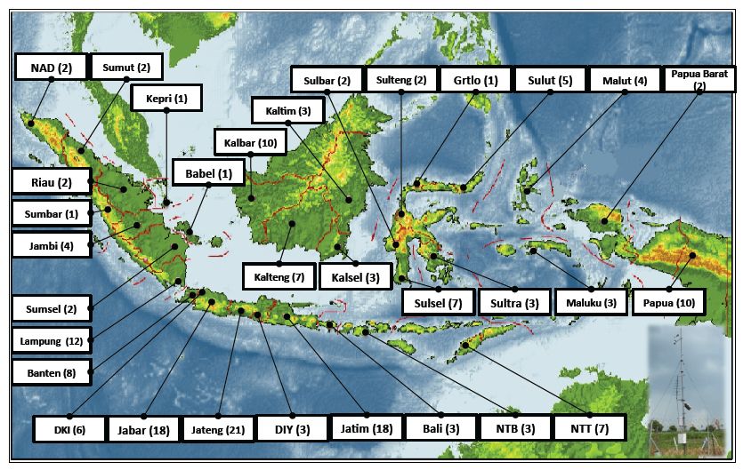
TABLE OF CONTENTS

EXECUTIVE SUMMARY ................................................................................................ 4
1. INTRODUCTION .......................................................................................................... 6
2. SCIENCE THEMES ....................................................................................................... 9
   2.1 Atmospheric Convection .......................................................................................... 9
       2.1.1 Dominant processes controlling the diurnal cycle ............................................. 9
       2.1.2 Diurnal and large-scale variability ................................................................... 12
       2.1.3 MJO propagation barrier .................................................................................. 14
       2.1.4 Boreal winter interactions between East and Southeast Asia and MC ............ 15
       2.1.5 Northward propagation/migration of MC convection ..................................... 17
   2.2 Ocean and Air-Sea Interaction ................................................................................ 18
       2.2.1 Upper ocean processes ..................................................................................... 19
       2.2.2 Air-Sea Interaction ........................................................................................... 22
   2.3 Stratosphere-Troposphere Interaction ..................................................................... 23
   2.4 Aerosol .................................................................................................................... 29
   2.5 Prediction Improvement.......................................................................................... 32
       2.5.1 Known prediction problems within the MC region ......................................... 32
       2.5.2 Known global prediction problems related to the MC..................................... 34
       2.5.3 Prediction model improvement and links to other themes............................... 35
3. OBJECTIVES ............................................................................................................... 36
4. MAIN ACTIVITIES ..................................................................................................... 37
   4.1 Data Sharing............................................................................................................ 37
   4.2 Field Campaign ....................................................................................................... 38
   4.3 Modeling ................................................................................................................. 38
   4.4 Prediction and Applications .................................................................................... 39
   4.5 Outreach and Capacity Building ............................................................................. 39
5. SYNERGY AND LEVERAGE WITH OTHER PROJECTS ...................................... 40
   5.1 Propagation of Intra-Seasonal Tropical Oscillations (PISTON) ............................ 40
   5.2 Cloud-Aerosol-Monsoon Philippines Experiment (CAMPEx) .............................. 40
   5.3 Tropical Pacific Observing System (TPOS) 2020 .................................................. 40
   5.4 International Indian Ocean Expedition 2 (IIOE-2) ................................................. 41
   5.5 Subseasonal-to-Seasonal Prediction Project (S2S)/MJO Task Force (MJOTF) Joint
   Maritime Continent Initiative ....................................................................................... 41
   5.6 CORDEX-Southeast Asia (CORDEX SA) ............................................................. 41

                                                                 2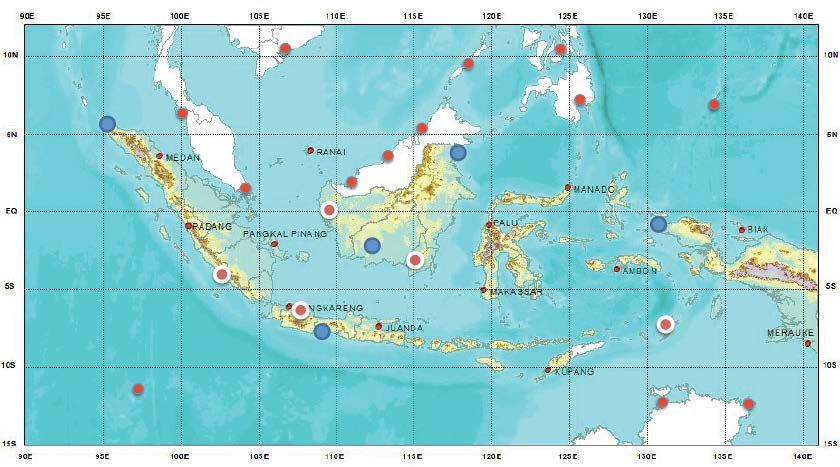
5.7 Year of Polar Prediction (YOPP)............................................................................ 42
5.8 7 Southeast Asian Studies (7SEAS) ....................................................................... 42
5.9 Stratosphere-troposphere Processes and their Role in Climate (SPARC) .............. 42
5.10 Strateole-2 ............................................................................................................. 42
6. CONTRIBUTORS TO THIS DOCUMENT ................................................................ 44
7. REFERENCES ............................................................................................................. 45
APPENDIX A POTENTIAL PARTICIPATIONS IN THE YMC FIELD CAMPAIGN 64
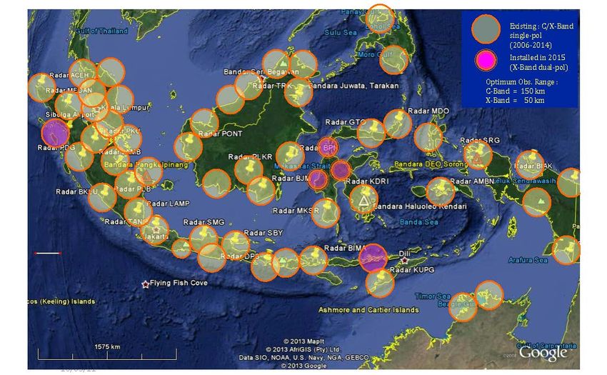
APPENDIX B REGIONAL OBSERVING NETWORKS............................................... 68
APPENDIX C PREVIOUS FIELD CAMPAIGNS IN THE MC .................................... 72
3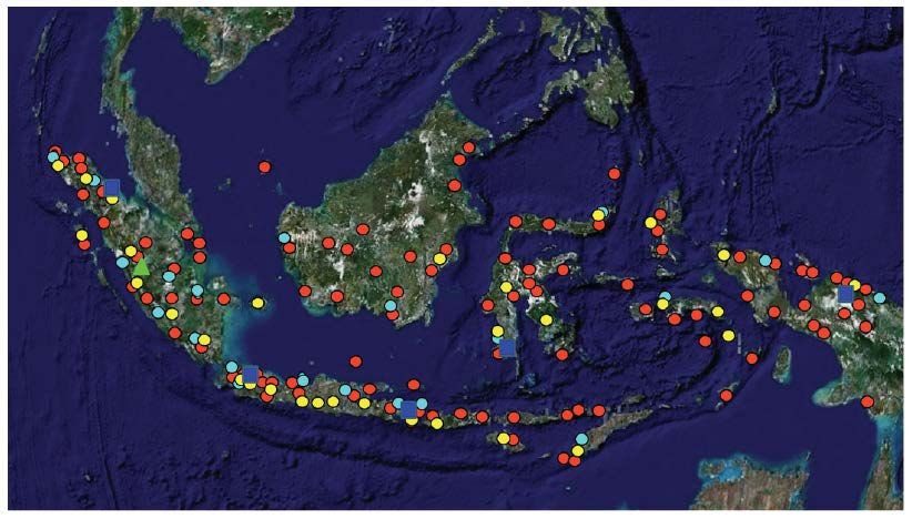
EXECUTIVE SUMMARY

The Maritime Continent (MC), a unique mixture of land and ocean straddling the equator
between the Indian and Pacific Oceans, is the largest archipelago on Earth. It is known for
its complex geophysical setting, its marine and land biodiversity, and its rich human history
and culture. Sitting in the middle of the warmest body of water known as the Indian and
western Pacific warm pool, the MC plays a pivotal role in the global weather-climate
continuum. The complex land-sea distribution and topography make prediction of high-
impact events in this region extremely challenging.

The intricacy of land, sea and terrain of the MC cultivates intriguing multi-scale variability
in rainfall and in the circulation, which breeds high-impact events such as flood and
drought. Predicting extreme events associated with the diurnal cycle, synoptic weather
systems, the Madden-Julian Oscillation (MJO), and the monsoons is of paramount
socioeconomic benefit to the region.

The MC hosts one of the major equatorial atmospheric convection centers. The tremendous
energy released by convective condensation over the MC fuels the global atmospheric
circulation. Rossby wavetrains excited by MC convection emanate toward higher latitudes.
The atmospheric large-scale upward motion associated with MC convection constitutes the
ascending branch of the Walker Circulation, the interannual zonal migration of which is a
key ingredient of the El Niño - Southern Oscillation (ENSO) variability. Teleconnections
related to the MJO are strongest when its convection is centered over the MC. But the MC
is a known barrier for the eastward propagation of the MJO. Atmospheric deep convection
penetrating the tropopause over the MC makes it a primary spot for vigorous stratosphere-
troposphere interaction. The Indonesian Throughflow (ITF), the artery connecting the
tropical Pacific and Indian Oceans, is a crucial link of the ocean general circulation that
affects not only properties of these two oceans but also global climate. Coastal upwelling
near Sumatra is a key ingredient of the Indian Ocean Dipole (IOD), an essential element of
the regional climate.

Unfortunately, current state-of-the-art global climate models (GCMs) and numerical
weather prediction (NWP) models suffer from persistent systematic errors and limited
predictions skill in the MC region. They cannot reproduce the observed diurnal cycle of
precipitation over the MC. They exaggerate the MJO barrier effect of the MC. They suffer
from systematic dry and wet biases in precipitation in the MC region. Even models with
the highest resolutions cannot reproduce observed rainfall variability and associated
dynamical features in the MC region. Prediction skill of rainfall, especially its extreme
events, in the MC is very limited.

"Years of the Maritime Continent (YMC)" is a two-year (July 2017 - July 2019) project.
Its overarching goal is to expedite the progress of improving understanding and prediction
of local multi-scale variability of the MC weather-climate system and its global impact
through observations and modeling exercises.

YMC includes five science themes:

                                              4
Theme 1: Atmospheric Convection. To advance understanding of physical processes
   governing diurnal, synoptic, intraseasonal and seasonal variability of atmospheric
   convection and their interaction under the influence of the complex land-sea
   distribution and topography.
Theme 2: Upper-Ocean Processes and Air-Sea Interaction. To advance understanding of
   controlling processes for the multi-scale diurnal, intraseasonal and seasonal variability
   of the ocean and air-sea interaction in the MC region under the influence of extremely
   complex bathymetry and islands.
Theme 3: Stratosphere-Troposphere Interaction. To advance understanding of processes
   governing the dynamical coupling of the stratosphere and troposphere and their mass
   exchanges over the MC.
Theme 4: Aerosol. To advance understanding of key processes by which the multi-scale
   variability and interaction of convection and circulation affect the production,
   transport, and disposition of aerosol and their interaction with clouds in the MC.
Theme 5: Prediction improvement. To improve representations of key processes in weather
   and climate models through use of field observations and improved understanding.

YMC will engage five main activities:

Data Sharing: Through collecting, archiving, and sharing data from observing networks in
    the MC region, satellites, and NWP products, build a two-year (July 2017 - July 2019)
    comprehensive database for detailed documentation of multi-scale variability and
    interaction of the MC weather-climate system.
Field Campaign: Collect special observation through a two-year (July 2017 - July 2019)
    field campaign to advance our understanding of physical processes key to the multi-
    scale variability and interaction of the MC weather-climate system.
Modeling: Quantify biases/errors of numerical models and the potential for improvement
    of prediction and simulation skill, and improve physical understanding through
    coordinated numerical experiments.
Prediction and Applications: Demonstrate prediction improvement through model
    improvement and assimilating supplementary data from activities 1 and 2; Study
    optimizations of targeted prediction products for users, information disassembling
    through modern media, and support to emergency management.
Outreach and Capacity Building: Educate the general public about the MC weather-climate
    system, its local variability and global impacts; Train the next generation of scientists,
    forecasters, and technicians for future research, operations, and applications of
    prediction and simulation tools.

In summary, through international collaboration and coordination, integrating observations
and modeling, bridging research and operations, and outreach and capacity building, YMC
strives to advance at an unprecedented pace our understanding and prediction of the MC
weather-climate systems for socioeconomic benefit both locally and globally.

                                              5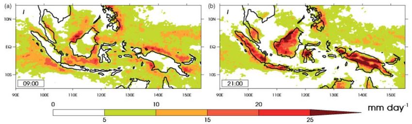
1. INTRODUCTION

The Maritime Continent (MC) of the Indian and Pacific Ocean is a unique mixture of land
and ocean. This largest archipelago on Earth consists of 25,000 - 30,000 islands, including
the world's second and third largest (see the cover page). The MC is known for its marine
and land biodiversity, and its rich human history and cultures. Sitting in the middle of the
warmest body of water known as the Indian and western Pacific warm pool, the MC plays
an unmatched role in the weather-climate continuum of the region and the world (Ramage
1966). The complex land-sea distribution and topography make prediction of high-impact
events in this region extremely challenging.

The MC is at the center of global multi-scale interactions involving the global mean
circulation and variability on a wide range of timescales including convective, diurnal,
synoptic, intraseasonal, seasonal, interannual, decadal, and longer periods (McBride 1998;
Chang et al. 2004a). It hosts one of the major equatorial atmospheric convection centers.
The tremendous energy released by convective condensation fuels the global atmospheric
circulation (Chang and Lau 1982; Lau et al. 1983; Sardeshmukh and Hoskins 1988). The
atmospheric large-scale upward motion associated with the MC convective center
constitutes the ascending branch of the Walker Circulation (Bjerknes 1969), with its
interannual zonal migration being a key manifestation of the ENSO variability (Philander
1985).

Both the summer and winter East Asian/Australian monsoons have their footprints over
the MC (Meehl 1987; Wang 1994). With its complex coastal lines and terrain, the MC
causes asymmetry in both latitudinal extension and temporal transition of the two
monsoons (Chang et al 2005). The seasonal cycle of rainfall in the MC, known as the
Maritime Continent monsoon (Chang et al 2005; Robertson et al. 2011), exhibits
substantially different characteristics among different islands. Some islands undergo
distinct wet vs. dry seasons with opposing phases; others receive almost perennial rainfall.
The seasonal march of the monsoon onset and withdrawal appears from both the west
(Indochina) and east (Australia) as seen in cloud activity (Matsumoto 1992; Matsumoto
and Murakami 1994).

The Madden-Julian Oscillation (MJO) often brings the onset of the austral summer
monsoon and the rainy season (Hashiguchi et al. 1995) and induces intraseasonal rainfall
variability in the MC (Hidayat and Kizu 2010). Probabilities of many global hazards (e.g.,
tropical cyclones, cold surges, extreme rainfall, lightning, and flood) depend on whether
an MJO convection center is stalled over the eastern Indian Ocean, passes over the MC, or
moves into the western Pacific (Zhang 2013). MJO-related teleconnections are strongest
when MJO convection is over the MC (Adames and Wallace 2014). The MC is, however,
a known barrier for the eastward propagation of the MJO (Nitta et al. 1992). Nearly 40%
of MJO events over the Indian Ocean fail to propagate through the MC.

Unique synoptic perturbations (e.g., Borneo vortices) help organize and sustain convective
systems beyond their individual lifespans and create distinct local weather patterns
(Johnson and Houze 1987; Chang et al. 2003). The mean and variability of rainfall over
the MC are also influenced by many other synoptic perturbations, such as equatorial waves,

                                             6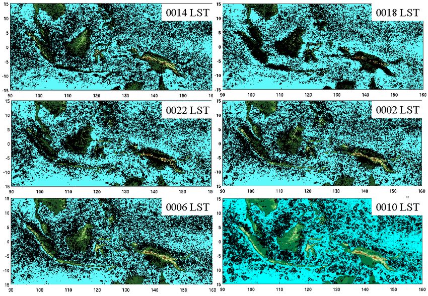
cold surges, and tropical cyclones. They can cause sequential flooding events over a broad
region of Southeast Asia (Wu et al. 2007; Yokoi et al. 2008).

The intricacy of land, sea and terrain in the MC region cultivates atmospheric convective
systems with an intriguing diurnal cycle (Houze et al. 1981; Johnson and Priegnitz 1981;
Williams and Houze 1987; Yang and Slingo 2001; Keenan and Carbone 2008; Kanamori
et al 2013). The diurnal cycle is modulated by the large-scale variability, such as the MJO,
monsoon, IOD, and ENSO (Murata et al. 2002; Sakurai et al. 2005; Rauniyar and Walsh
2011; Peatman et al. 2014). The multi-scale (diurnal, synoptic, intraseasonal, seasonal, and
interannual) variability of rainfall nourishes the agriculture but also breeds damaging
extremes in the MC region, such as severe storms, floods and droughts (Aldrian and Djamil
2008; Tangang et al. 2008; Wu et al. 2007 and 2013; Tabata et al., 2011b). The complex
geographical setting, multi-scale variability, and models' difficulty at simulating
convection in this region at all time and space scales make prediction of rainfall, especially
its extreme events, in the MC region daunting challenges.

Frequent deep atmospheric convection penetrating through the tropopause over the MC
makes it a primary spot for vigorous stratosphere- troposphere interaction. Approximately
83% of the global tropospheric air mass that enters into the tropical tropopause layer and
71% that enters the stratosphere does so over the MC and western Pacific (Fueglistaler et
al. 2004). This marks the importance of the MC in large-scale stratospheric variations, such
as stratospheric sudden warming, polar vortex intensification , the quasi-biennial
oscillation, the semi-annual oscillation (SAO), etc., all having great global impacts.

The Indonesian Throughflow (ITF) is the only artery connecting two tropical oceans: the
Pacific and Indian Oceans. Through air-sea interaction in the Indonesian Seas and active
vertical mixing, the ITF cools and freshens the Indian Ocean thermocline (Gordon 2005).
By carrying mass, heat, and freshwater, the ITF transfers climate signals in the global
thermohaline circulation and influences the regional air-sea exchange and precipitation
patterns over many time scales (Sprintall et al. 2014). In consequence, the ITF plays a vital
role in the global climate system (Schneider 1998; Wajsowicz and Schneider 2001; Le Bars
et al. 2013). The Pacific-Indian Ocean warm pool that embeds the MC is the main driving
force of the global atmospheric circulation. Any modulation of the upper ocean heat
content by oceanic processes and air-sea interaction could have a large impact on local and
tropical climate (Koch-Larrouy et al. 2010). The archipelago is one of the regions in the
world with the largest internal tides generation (10% of the global value), which produce
intense vertical mixing, that upwells cool waters at the surface that reduce precipitation
and thus modify tropical mean state and variability (Koch-Larrouy et al. 2010). The impact
on sea temperature and salinity of the internal tidal Indonesian mixing over the Indian and
Pacific tropical oceans is as strong as when closing the ITF, emphasizing the key role of
the Indonesian archipelago on the Indo-Pacific climate.

Air-sea interaction is also active and important in the Indonesian Seas and surrounding
waters, such as the South China Sea (SCS) and Philippine Sea. The SCS throughflow feeds
fresh water to the ITF. Air-sea interaction in the Philippine Sea provides moisture not only
for the MC monsoon but also for the Asian summer monsoon (Wang 2006).

                                              7
The west coast of the MC blocks eastward propagation of oceanic equatorial Kelvin waves
excited in the Indian Ocean, generating coastal waves that move toward higher latitudes
and carry equatorial ocean dynamical signals to the extratropics. Coastal upwelling near
Sumatra is a key ingredient of the Indian Ocean Dipole (IOD, Saji et al. 1999; Webster et
al. 1999), which is an essential feature of the regional climate.

Given the pivotal role of the MC in the regional and global weather-climate continuum, it
is imperative that key processes of the ocean, atmosphere, land and their coupling, and the
multi-scale variability and interaction in the MC region are well represented in numerical
models. Unfortunately, current state-of-the-art global climate models (GCMs) and
numerical weather prediction (NWP) models suffer from persistent systematic errors over
the MC. Critical upper-ocean mixing processes are often missing in the models. Models
cannot reproduce the observed diurnal cycle of precipitation over the MC. They suffer from
large systematic biases in mean rainfall in the MC region, often with distinct contrasts
between the ocean and land. They exaggerate MC barrier effect on the MJO. In NWP
models, this leads to an MC prediction barrier for the MJO. Even models with the highest
resolutions fail to reproduce observed dynamical features such as realistic vertical velocity
profiles in atmospheric deep convection in the MC region.

Many countries in the MC region and Southeast Asia are highly susceptible to hydrological
perturbations on a wide range of timescales. Severe tropical cyclones, the MJO, and intense
monsoonal activity frequently bring dramatic flooding to the region. Periods of drought
also have significant adverse effects on people and agriculture of the region. In order to
facilitate water planning and emergency response strategies, it is critical to understand how
weather extremes will be affected by changing climate and how their societal impact will
become more severe in the face of increasing populations.

Given the global importance of the MC, it is no double that improving our ability to
simulate and predict the regional and global weather-climate continuum critically depends
on advancing our understanding of key processes of the ocean, atmosphere, and their
coupling in the MC. Detailed observations in the MC are irreplaceable elements for this.
The intricate distributions of the ocean, land, and their topography make it a daunting
challenge to attain observational data that unravel connections among different
components of the MC system as well as specific information for each component.
Collecting such data is beyond any single institute or even single country. Concentrated
and coordinated international efforts are needed.

"Years of the Maritime Continent" (YMC) is conceived in this spirit. The main goal of
YMC is to observe the weather-climate system of Earth's largest archipelago to improve
understanding and prediction of its local variability and global impact.

YMC will cover a two-year period including both winter and summer East
Asian/Australian monsoons: July 2017 - July 2019. It includes five science themes:
Atmospheric Convection, Ocean and Air-Sea Interaction, Stratosphere-Troposphere
Interaction, Aerosol, and Prediction Improvement. YMC will engage five main activities:
Data Sharing, Field Campaigns, Modeling, Prediction Improvement, and
Outreach/Capacity Building. The main anticipated outcomes of YMC would be: (a) a two-

                                             8
year (July 2017- July 2019) comprehensive data archive from regional observing networks,
satellite observations, and field campaigns. This data archive will include diverse
observations needed to document the detailed multi-scale variability in the MC; (b)
advanced understanding of physical processes of the weather-climate system of the MC
that are key to its local multi-scale variability and global impact; (c) improved model
capability of simulating and predicting the weather-climate system of the MC and
demonstration of its benefit to the society; and (d) a new generation of scientists and
technicians who will be the intellectual core of operation and research in the MC for years
to come.

The YMC science themes are introduced and discussed in section 2. The scientific
objectives of YMC are summarized in section 3. The YMC activities are briefly described
in section 4. Leverage and synergy with relevant programs are discussed in section 5.
Contributors to this document are listed in section 6. References are in section 7. Appendix
A lists potential participation in YMC. Appendix B introduces regional observing networks
in the MC. Appendix C lists and briefly discusses previous field campaign in the MC.

2. SCIENCE THEMES

2.1 Atmospheric Convection
Atmospheric convection in the MC region undergoes substantial multi-scale variability on
the mesoscale, diurnal, synoptic, intraseasonal, and seasonal scales. Mechanisms for the
multi-scale variability and their cross-scale interaction are not well understood and are at
the center of this theme.

2.1.1 Dominant processes controlling the diurnal cycle
The diurnal cycle can be considered the heart beat of the multi-scale variability in the MC
region. Observations from the surface (Houze et al. 1981; Johnson and Priegnitz 1981;
Kamimera et al. 2012; Kanamori et al 2013) and from satellites (Williams and Houze 1987;
Yang and Slingo 2001; Nesbitt and Zipser 2003; Ichikawa and Yasunari 2006; Keenan and
Carbone 2008) have documented diurnal cycle in the MC region. The climatological
diurnal cycle in rainfall manifests as a systematic phase shift between land and water (Fig.
2.1). Over land (island) rainfall starts near coasts in the local afternoon, and quickly reaches
its peak in early night. Around midnight, rainfall signals move from the land to the adjacent
water. Offshore rainfall reaches its maximum in the early morning, with extensive anvils
and stratiform rain that gradually dissipate around local noon. The largest amplitude of the
diurnal cycle occurs along the coast of major islands and near mountain ranges, with
weaker amplitude over the open ocean away from the coast (Nitta and Sekine 1994;
Ohsawa et al. 2001; Mori et al. 2004), correlated and migrated with sea-land breeze
circulations (Hashiguchi et al. 1995; Hadi et al. 2002; Sakurai et al. 2005; Araki et al. 2006;
Tabata et al. 2011b). The diurnal cycle over the MC is particularly strong in rainy days and
in the rainy season (Wu et al. 2003, 2009).

                                               9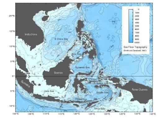
Figure 2.1 Mean precipitation rate (mm day-1) derived from TRMM for 11 Oct 2008 – 8 April 2009 at (a)
0900 LST and (b) 2100 LST. From Love et al. (2011).

The solar cycle ultimately controls the triggering of new convection over land, with sea
breezes and upslope flows playing an important role. The time of maximum coverage by
rain and high cloud depends on the lifecycle of mesoscale convective systems (MCSs) that
evolve from the triggered convection (Houze et al. 1981), suggesting the importance of the
convective scale, growth, and organization.

The processes controlling the offshore migration of precipitating systems are not well
understood. They may be related to: land breezes (Wapler and Lane 2012; Houze et al.
1981), propagating gravity waves generated by the diurnal heating (e.g., Mapes et al. 2003)
or by moist convection over land (Love et al. 2011), outflow associated with the land
convection that took place overnight (Fujita et al. 2010), or a combination of the three.
These suggested mechanisms are different from those proposed to explain the diurnal cycle
over the tropical open ocean that involve interaction between convection, radiation, and
surface fluxes (Chen and Houze 1997; Randall et al. 1991). As the offshore propagating
systems are organized on the mesoscale (Houze et al. 1981), the up-scale growth of the
convection is of critical importance over the entire diurnal lifecycle.

There are spatial variations in the characteristics of the diurnal cycle in the MC region (Fig.
2.1) related to the timing of the peak in convection over land and the existence and extent
of the offshore propagating convective systems. These differences are likely related to
aspects of the island size and orientation, and terrain height. Moreover, differences in island
geometry should help determine how the diurnal cycle responds to changes in large-scale
conditions (see next section).

The diurnal cycle over the islands and coastal regions is closely related to the land-sea
heating contrast and the soil moisture condition, which depends on both precipitation
frequency and the timescale of soil moisture retention (Wei et al., 2008). During the past
decade, the deforestation rate over the MC region has been among the highest in the world
(Margono et al. 2014). Changes to land surface characteristics, including soil moisture and
runoff, may have significantly modify aspects of the diurnal cycle.

Many of these characteristics of the diurnal cycle can be seen from cloud cluster
distributions shown in Fig. 2.2. This figure also reveals other features of the diurnal cycle
that have not been sufficiently emphasized in the existing literature. It appears that along
some coastlines the inland-propagating and offshore-propagating convective systems are

                                                 10
not initiated at the same time. While convection inland tends to disappear completely near
mid-morning, convection over water away from land is perpetual. As convection initiated
near the coast propagates offshore, it must interact with convection initiated over water.
The distance from the shore at which oceanic convection is affected by land-initiated
convection is not well known.
Figure 2.2 Diurnal cycle of cloud clusters defined as cloud top brightness temperature < 208 K. Sizes of the
circles are proportional to cluster sizes (> 100 km2). Courtesy of Shuyi Chen and Brandon Kerns.
One common systematic error of climate models is their incorrect diurnal cycle in the
timing and amplitude of the convective peak (Takayabu and Kimoto 2008; Love et al.
2011). This error depends sensitively on cumulus parameterization (Sato et al. 2009;
Stratton and Stirling 2011; Folkins et al. 2014). Models in which convection is explicitly
resolved can produce an improved representation of the diurnal cycle in the MC region
(e.g. Pritchard and Somerville 2009), although do not alleviate all deficiencies. Better
resolved distributions of land, sea, and topography, their related circulations (land-sea
breezes, mountain-valley flows), and the associated patterns and motions of convergence
and convective systems are very important to reduce the biases not only in the diurnal cycle
but also in overall magnitudes of precipitation in the MC region (Qian 2008; Ploshay and
Lau 2010, Hagos et al. 2013).
Specific outstanding questions pertaining to the diurnal cycle include:
• What is the relative role of sea breezes in initiating convection in comparison to
local thermally forced convergence over land?
11• How does the local orography affect the diurnal evolution of convection in
comparison to that over a flat island?
• What is the relative role of land breezes, storm outflows, and gravity waves in
controlling the offshore propagation of convective systems?
• How do the dominant processes controlling initiation and offshore propagation vary
with island geometry and orientation, and land surface characteristics including
vegetation and soil moisture?
• How far may the land effect extend into the ocean through the diurnal cycle and
how does convection propagating from land interact with convection initiated over
water?
• How do MCSs modulate upper ocean properties and what is the role of the ocean
in their development on the diurnal timescale?
• To what degree is the inability of models cumulus parameterization to reproduce
the observed diurnal cycle rooted in their deficiencies in accurately presenting
convective triggering, propagation, and growth?
• What are the relative contributions from deficiencies in cumulus parameterization,
unresolved details of the sea-land-topography distribution, and other factors (e.g.,
large-scale conditions) to the inability of climate models to reproduce the observed
diurnal cycle in the MC region?
The following hypotheses have been developed relating to the diurnal cycle of MC
convection:
Hypothesis 1.1: The diurnal cycle of convection in the MC region involves three steps: (i)
Triggering, which occurs over both land near coasts due primarily to sea-breeze
convergence and land heating destabilization, and open water due to interactions of
convective clouds, surface fluxes, and radiation; (ii) Propagation, which takes place from
the coastal region to inland mountains as well as to open water due to gravity waves,
sea/land breezes, and/or convective outflows; (iii) Upscale growth through aggregation and
organization, which leads to the formation of MCSs with lifespans beyond a single diurnal
cycle.
Hypothesis 1.2 The contrasts between convection over land and water and between
convection around different islands come mainly from the relative roles the above three
steps of the diurnal cycle play.
2.1.2 Diurnal and large-scale variability
Understanding the diurnal behavior of precipitation over the MC is essential to
understanding convective coupling with larger-scale circulations in the tropics. Several
studies have documented the relationship between the diurnal cycle in the MC with the
monsoons (Houze et al. 1981; Johnson and Priegnitz 1981; Churchill and Houze 1984a,b),
the MJO (Chen et al. 1996; Houze et al. 2000; Tian et al. 2006; Ichikawa and Yasunary
2007; Rauniyar and Walsh 2011; Oh et al. 2012; Peatman et al. 2014), and synoptic-scale
perturbations (Houze et al. 1981). The MJO modulates the amplitude of the diurnal cycle
(by up to 10 mm day-1). This amplitude modulation by the MJO occurs over both land and
ocean in the MC region, but the effect is stronger over the sea than land, and is particularly
12strong near coasts (Rauniyar and Walsh 2011). In regions where there is a strong diurnal
cycle, about 80% of the MJO precipitation signal is accounted for by changes in the diurnal
amplitude (Peatman et al. 2014).
The strength and organization of diurnally varying MC convection can have significant
impacts on precipitation organization at daily and longer timescales. For example,
improving model representation of the diurnal cycle in the MC region led to reduced biases
in mean precipitation (Love et al. 2011). A particularly salient example is the modulation
of the diurnal cycle in the MC region by the MJO (Fig. 2.3). The diurnal cycle of convection
in land regions of the western MC peaks in advance of the arrival of the broader oceanic
convective envelope in this region. Daily mean precipitation over land and coastal regions
peaks during the period of the strongest diurnal cycle amplitude, in advance of the daily
mean precipitation maximum over water. As a result, the propagation of the MJO appears
faster over the MC than over the Indian and Pacific oceans (Peatman et al. 2014)
Figure 2.3 Means of brightness temperature (Tb), daily mean rainfall (r), and the diurnal cycle amplitude
(rd), all averaged separately over land and ocean, for the region 7°S-10°N, 100-120°E (most of Sumatra and
Borneo), plotted against MJO phases. Solid black lines show Tb (bold for ocean, thin for land); dashed lines
show r and rd (long- dashed for ocean, short-dashed for land). From Peatman et al. (2014).
Key research questions regarding the modulation of the diurnal cycle by large-scale
variability include:
• What are the mechanisms through which the diurnal cycle in the MC region is
modulated by large-scale atmospheric and oceanic conditions and land surface
characteristics on the intraseasonal and seasonal timescales?
• How do variations in the amplitude and organization of diurnally varying
convection feed back to intraseasonal and seasonal variability?
Two hypotheses on multi-scale interaction related to the diurnal cycle are proposed:
Hypothesis 1.3 Large-scale conditions related to the MJO and monsoon modulate the
diurnal cycle through affecting the timing, location, and/or vigor of convective triggering,
propagation, and/or growth.
13Hypothesis 1.4 Responses of the diurnal cycle to large-scale forcing over land and water
and over different islands are not the same because convective triggering, propagation and
growth mechanisms are modulated differently by large-scale variability.
2.1.3 MJO propagation barrier
In the MC region, the MJO significally modulates many processes in the region, including
the diurnal cycle of atmospheric convection, aerosol transport, and air-sea interaction. The
behavior of the MJO over the MC is very different from that over the open waters of the
Indian and western Pacific Oceans. In observations, when the MJO propagates over the
MC it often weakens, its propagation speed becomes uneven, and it may completely break
down and fail to reemerge on the Pacific side (about 40% of MJO events formed over the
Indian Ocean do so). This is known as the "MJO propagation barrier". The natural MC
barrier effect is commonly exaggerated in numerical weather prediction models and
climate models (Inness et al. 2003; Inness and Slingo 2006; Vintzileos and Pan 2007),
creating a "Maritime Continent prediction barrier" for the MJO. The strongest
teleconnection pattern from the tropics to extratropics generated by the MJO occurs when
an MJO convection center is located over the MC and close to the exit of the northern
hemispheric westerly jet (Adames and Wallace 2014). Failing to propagate MJO
convection through the MC in prediction models would inevitably undermine the model
capability of forecasting global influences of the MJO.
Three factors have been considered as possible reasons for MJO propagation to be
interrupted by the MC in nature: a reduced surface moisture source (Sobel et al. 2008)
because of the land coverage, interference with low-level flow by the topography (Inness
and Slingo 2006; Wu and Hsu 2009), and an energy drain through the strong diurnal cycle
in precipitation over land (Neale and Slingo 2003). The MC prediction barrier of the MJO
is likely due to deficiencies in model physics (Neena et al. 2014) that are manifested in the
poorly simulated convection in the MC region, in addition to coarse model resolutions that
do not resolve the necessary details of the sea-land-topography distribution crucial for
convective variability.
The modulation of the diurnal cycle by the MJO is uneven over land and water not only in
the timing and amplitude of rainfall (section 2.1.2), but also in sizes of MCSs. Figure 2.4
indicates that the modulation on the diurnal cycle of convection by the MJO is much larger
over water than over land. The strongest contrast between MJO active and suppressed
phases is the number of large MCSs over water. This may have two implications. One is
the mechanism by which the MJO modulates the diurnal cycle. The other is possible
feedback of the diurnal cycle to the MJO.
Pressing issues related to the role of the MC in the MJO can be discussed from two aspects:
processes in reality and their reproduction in numerical models.
• What processes determine the strength, propagation speed, and rainfall distribution
of the MJO over the MC? Specifically, what are the roles of the diurnal cycle, air-
sea interaction, land-sea distribution, and topographically modified flow in
regulating MC influences on the MJO?
14• To what extent the evolution of the cloud population over the MC through a life
cycle of the MJO is different from that over the open oceans and to what extent
such difference results in the unique behavior of the MJO over the MC?
• How is an incorrect diurnal cycle in a numerical model related to its erroneous
simulation of the MJO in the MC?
Figure 2.4 Comparison of the diurnal contrast of cloud clusters (defined as cloud top brightness temperature
< 208 K) during MJO active and suppressed phases. Sizes of each circle are proportional to the cluster sizes
(> 100 km2). Courtesy of Shuyi Chen
Possible interactions between the diurnal cycle and MJO lead to the following hypotheses:
Hypothesis 1.5 Modulation of the diurnal cycle, especially that over water in the MC, by
large-scale variability associated with the MJO is instrumental to the propagation of MJO
convective signals through the MC. Oceanic convective growth and organization into
MCSs are the major convective signal of the MJO propagating through the MC.
Hypothesis 1.6 The inability of global models to properly represent the salient processes
for the triggering, propagation, and growth of diurnal convection and the formation of
MCSs over the MC water limits their ability to propagate the MJO though the MC.
2.1.4 Boreal winter interactions between East and Southeast Asia and MC
The southward and eastward movement of the Siberian High, which is strongly influenced
by the East Asian Major Trough and jet stream, is an important part of tropical-midlatitude
interaction. These movements often trigger cold surges that pass through the South China
Sea (SCS) and reach and cross the equator (Chang et al. 2006, 2015). Cold surges are
associated with enhanced upper-tropospheric outflow over the MC and an enhanced East
Asian meridional overturning circulation that may strengthen the East Asian jet and lead
to further interactions with the midlatitude systems (Chang and Lau 1982; Lau and Chang
1987; Neal and Slingo 2003). Cold surge air is moistened along trajectories over water
15(Johnson and Houze 1987). It can considerably reduce SST of the SCS (Li et al. 2006).
This midlatitude-tropical feedback makes the Asian winter monsoon one of the most
energetic planetary-scale circulation systems on Earth (Chang et al. 2006).
In addition to the synoptic-scale cold surges, tropical convection in the SCS and the western
MC region is also affected by local sea surface temperature (Hendon 2003; Yang et al.
2012; Koseki et al. 2013) and other disturbances including the Borneo vortex (Chang et al.
2005, 2006, 2015) and the MJO (Yang et al. 2015). Borneo vortices are most active during
boreal winter when its intensity is often modulated by the cold surges. Their associated
convection, MCS and even tropical depression formation associated may interact with the
local diurnal cycle.
The MJO reduces the frequency of weaker surges by interfering with their structure (Fig.
2.5). The MJO has peak amplitude over the MC during the boreal winter, typically when
synoptic activity is weak and the diurnal cycle is prominent (Qian et al. 2013; Lim et al.
2013; Peatman et al. 2014). As synoptic-scale convection, intraseasonal convection in the
MC region can strengthen the local meridional overturning circulation and the East Asian
jet (Jeong et al. 2008; He et al. 2011). The strongest extratropical wave trains emanate from
the exit of the northern hemispheric westerly jet when MJO convection is located over the
MC (Weickmann 1983; Lau and Phillips 1986, Matthews et al. 2004, Mori and Watanabe
2008, Frederiksen and Lin 2013, Adames and Wallace 2014).
Figure 2.5 The percentage of days containing a Borneo vortex relative to the surge intensity, for all (total)
days, no-MJO days, and MJO days. The surge intensity is the average 925 hPa northerly wind along 15°N
between 110°E - 117.5°E. (From Chang et al
Key research questions to be addressed by YMC include:
• Does the Siberian High affect the variability of convection in the SCS and the MC
region on intraseasonal, seasonal, and longer timescales through synoptic-scale
cold surges?
• How does convective variability associated with cold surges, Borneo vortex, and
MJO feedback to the East Asian Jet and East Asian Major Trough?
16Multi-scale convective interactions are the key to the connection between MC convection
and high-latitude systems, as stated in the following hypothesis:
Hypothesis 1.7 The influence of the Siberian High (SH) on MC convection varies on
intraseasonal, seasonal, and interannual timescales through modulation of synoptic- scale
cold surges in the SCS on these timescales.
2.1.5 Northward propagation/migration of MC convection
Boreal summer intraseasonal oscillations (BSISOs) are generally characterized by
eastward propagating cloud clusters from the equatorial Indian Ocean to western Pacific
with pronounced northward propagation over Indian Ocean, MC and western Pacific (e.g.
Lau and Chan 1986; Nitta 1987; Wang and Rui 1990; Kikuchi et al. 2012; Lee et al. 2013).
Two types of mechanisms have been proposed to explain northward propagation of the
BSISO. The first type of mechanism includes the interaction between the mean seasonal
flow and intraseasonal perturbations (Jiang et al. 2004; Drbohlav and Wang 2005, Bellon
and Sobel 2008), interaction between the mean flow and small-scale, convective
momentum transport (Kang et al. 2010), and the self-advection of a cyclonic perturbation
(Boos and Kuang, 2010). The second type mechanism involves air-sea interaction
processes (Hsu and Weng 2001; Fu et al. 2003; Fu and Wang 2004; Bellon et al. 2008)
through BSISO-induced changes in surface fluxes of latent heat and solar radiation. The
latent heat flux is modulated by convection-coupled Kelvin-Rossby components of the
MJO flow superimposed on the mean summer monsoon flow that leads to positive
(negative) SST anomalies to the north (south) of the convective disturbance. Both increased
downward solar radiation and the reduced evaporation contribute to significant warming
in the northern Indian Ocean and SCS. The combined changes in latent heat flux and solar
radiation in the MC and SCS cause SST fluctuations that feed back to the circulation
through convective heating (Wang et al. 2009).
During boreal summer, moist southwesterly to westerly winds into South China Sea (SCS)
and Philippine Sea (PhS) bring seasonal rainfall to Indochina peninsula and the Philippines
(Wang 2006). Meanwhile, cross-equatorial flows from the southern hemisphere pass
between MC inner islands and merge into the SCS and PhS (Chang et al. 2005; Kubota et
al. 2011). Over the warm pool of the PhS and SCS, the western North Pacific summer
monsoon dominates (Murakami and Matsumoto 1994). Its seasonal and interannual
variability influences the intensity of cross-equatorial flows and directly impacts rainfall
(Kubota et al. 2011) and air-sea interaction (Kida and Richards 2009) in the MC, and
coastal upwelling along Sumatra and Java Seas (Susanto et al. 2001). The convective
heating of this monsoon generates Rossby wave response poleward known as the "Pacific-
Japan" pattern (Nitta 1987). This teleconnection pattern is a dominant component of
interannual variability of the western North Pacific and East Asian summer monsoons and
is connected to El Niño Southern Oscillation (ENSO) and tropical cyclone activities in this
region (Kubota et al. 2014). Over the SCS and PhS, the negative correlation between SST
and rainfall (Lu and Lu 2014) restricts the predictability of he monsoon (Wang et al. 2005).
Although the mechanisms discussed above provide a useful conceptual framework for
understanding the northward propagation of BSISO, the observed evolution of BSISO in
the MC and SCS region exhibits complex behavior (Wang et al. 2009) characterized by a
17connection with the eastward-propagating MJO (Chen and Murakami 1988; Wang and Rui
1990; Lawrence and Webster 2002), northwestward propagation from the equatorial
western Pacific, merging of an equatorial eastward-moving convective systems and
westward propagating lower-level convergence anomaly located in the subtropics (Hsu and
Weng 2001), and independent northward propagation (Wang and Rui 1990).
Key research questions to be addressed by YMC include:
• How does the Asian summer monsoon, especially over the SCS and western North
Pacific, link to rainfall, air-sea interaction, and coastal upwelling in the MC?
• What are the physical processes governing the inter-event variability of the BSISO
over the MC and SCS?
• What is the relative importance of moisture transport by different large-scale
processes (monsoon, BSISO, and higher-frequency perturbations) and air-sea
fluxes to the northward propagation of the MC convection?
The following hypothesis on the mechanisms for the northward propagation of MC
convection and the monsoon over the SCS and western North Pacific is proposed:
Hypothesis 1.8 Northward propagation of the boreal summer intraseasonal oscillation
arises from propagating air-sea interaction processes associated with the MJO and
biweekly Rossby waves interacting with the SCS monsoon during the period from late May
to Mid-July; the following Western North Pacific summer monsoon forms by remote
monsoon flow through SCS and MC, and local air-sea interactions
2.2 Ocean and Air-Sea Interaction
The MC is composed of over 17,000 islands within the complex array of shallow and deep
marginal seas (Fig 2.6). The MC seas share a common trait of warm, relatively low salinity
surface layer ofFigure 2.6 Sea floor topography (Smith and Sandwell, 1997)
2.2.1 Upper ocean processes
Significant oceanic advective and mixing processes within the Indonesian seas shape the
SST spatial and temporal patterns and associated air-sea coupling, as well as the nutrient
distribution in the surface ocean. On seasonal time scales, the upper ocean is forced by
monsoonal winds, which change direction crossing the equator. The SST responds to the
monsoonal forced radiation balance and wind field (Qu et al., 2005). From December to
February (Northwest monsoon) warm SST (> 29°C) are shifted southward relative to the
June-August (Southeast monsoon) pattern. In the expanse of the deep eastern seas (e.g.
Banda Sea) a deeper thermocline with a thicker warm surface layer occurs during the
northwest monsoon than during the Southeast monsoon when the wind stress curl
intensifies the cyclonic circulation and upwelling within the Banda Sea, lifting the
thermocline by ~ 40 m and leading to cooler SST by ~3°C (Gordon and Susanto, 2001). It
is expected that the atmospheric forcing of SST will dominate when the thermocline is
deep during the Northwest monsoon whereas during the Southeast monsoon the ocean's
role in governing SST may be enhanced. Wind-induced Ekman upwelling results in cooler
SST bands in the shallow Java and Flores Seas north of the island chain during the
Northwest monsoon, and south of it in the Indian Ocean during the Southeast monsoon.
In addition to the regional wind forcing the SST patterns are further shaped by the
circulation, notably the ITF consisting of ~15 Sv of Pacific water flowing towards the
Indian Ocean, as well as vigorous tides that induce strong vertical mixing. An upper ocean
heat-balance model suggested that during the northeast monsoon when vertical mixing and
air-sea heat fluxes cool the SST, lateral advection from the ITF entering via Makassar Strait
acts to warm the SST resulting in only a weak SST seasonality in the Flores Seas (Kida
and Wijffels, 2012). Buoyant surface water derived from the SCS throughflow (Luzon
Strait to the Sulu and Indonesian seas) varies both seasonally and with the ENSO phase,
being stronger in boreal winter and during El Niño. This freshwater influences the ITF
profile, resulting in a velocity maximum within the upper thermocline and a cooler ITF
19than if it were surface intensified (Gordon et al., 2003, 2012). The outflow of SCS
throuflow in Karimata Strait can contribute to ITF about 20% during winter (He et al.,
2014). Thus, the SCS throughflow has the effect of significantly reducing the ITF heat
transport, with considerable impact on heat distribution in the MC and the tropical Indian
Ocean (Song and Gordon, 2004), as well as affecting the western Pacific warm pool
(Sprintall et al., 2014). The equatorial wind stress in the tropical Pacific plays an important
role in regulating both the SCS throughflow and ITF (Wang et al., 2006; Liu et al., 2006).
Imprinted on the seasonal patterns of SST are the intraseasonal signals imposed by ocean
Kelvin waves (Drushka et al., 2010; Pujiana et al., 2013) and from the MJO. Intraseasonal
variation accounts for about 40% of SST variability, with the strongest signature observed
in Banda Sea and Timor Seas (Napitu et al., 2015). The MJO signature in SST is evident
with an SST variance energy peak at 35 days that amplifies during the northwest monsoon
and propagates eastward. In the Banda Sea, the influence of the MJO on SST is greatest
during the northwest monsoon, when the thicker mixed layer and deeper thermocline
(Gordon and Susanto, 2001) act to diminish the role of ocean processes driving vertical
heat transfer between subsurface and surface layers. Consequently, surface air-sea heat
fluxes associated with the MJO largely govern intraseasonal SST variability (Zhang 2005).
However, during the southeast monsoon the shallower mixed layer and shallower
thermocline are favorable for the role of ocean processes to mediate heat transfer between
the lower and upper layers of the ocean. During this period, the heat transfer competes with
surface the MJO heat fluxes in governing SST variability as indicated by a less pronounced
eastward propagation. It is likely that many of the same ocean processes that play a role
governing SST variability on seasonal time scales also influence intraseasonal SST
variability. For example, modulation of SST by barrier layer thickness can have significant
consequences for the response of the ocean to MJO and in turn, the feedbacks of the ocean
to the atmosphere on MJO time scales (Drushka et al., 2014). A thick barrier layer reduces
entrainment cooling during active MJO events resulting in a weaker SST anomaly.
Conversely, a thinner barrier layer results in a 15% stronger heat flux and wind stress, 10%
more precipitation and a higher mixed layer temperature. Waters on the shallow continental
shelves are also likely influenced by lateral advective processes, river runoff and wind
mixing that can mix the entire water column (Kida and Richards, 2009)
Dissipation of the energetic tide within the Indonesian seas results in large diapycnal
mixing coefficients of the order 1-10 cm2/sec that act on the stratified pycnocline (Ffield
and Gordon 1992), leading to a cooler SST, and inhibiting atmospheric convection (Ffield
and Gordon1996; Koch-Larrouy et al. 2008a, b and 2010). The dissipation and vertical
diffusivity and its imprint on SST varies markedly both spatially and temporally, notably
with the tidal patterns but also in relation to wind bursts associated with the monsoon and
MJO variability. Models that include parameterizations of the mixing in the Indonesian
seas decrease the annual mean SST by ~0.5°C, increase ocean heat uptake by ~20 W/m2
and reduce the overlying deep convection by as much as 20%, all changes that align the
model output in better agreement with the observations (Koch-Larrouy et al., 2010,
Sprintall et al. 2014). Consequently, the trade wind convergence is reduced, decreasing the
thermocline tilt in the Pacific Ocean, and in turn modifying the interannual variability of
the Pacific and Indian Ocean. Similarly, on intraseasonal time scales, coupled models show
SST variability modulated due to internal tidal mixing, again in better agreement with
20observations: over the annual cycle rainfall is reduced over the MC, while during the
Northwest monsoon, rainfall is reduced over the entire tropical Indian Ocean due to mixing
within the Indonesian Seas. While models suggest small-scale mixing plays a significant
role in SST variability, mixing observations within the Indonesian seas are still few.
Turbulent mixing at the inertial time scale has been observed at the base of the mixed layer
in the Banda Sea (Alford and Gregg, 2001), and strong tidal mixing above sharp
topography and in energetic narrow straits has been inferred from temperature profiles
(Ffield and Gordon 1996; Ffield and Robertson, 2005) and more recently from the first
direct measurements in regions of high energy of internal tidal dissipation (Koch-Larrouy
et al. 2015). The intense mixing also likely contributes to a large flux of nutrients that
support high productivity of the Indonesian seas, although again there are few
observational studies to support this.
The Eastern Indian Ocean Upwelling (EIOU) region is driven by the monsoonal wind but
also lies along the porous western boundary of the Indonesian archipelago where the ITF
exits into the Indian Ocean. The EIOU develops during boreal summer, but also has
profound impacts on regional and global climate through its intensive interaction with the
atmosphere during Indian Ocean Dipole (IOD) events. The Indo-Australian monsoon onset
often coincides with the arrival of the first eastward propagating MJO event during austral
summer (Hendon and Liebmann 1990), although the structure and mechanism of this first
event are still not fully understood. Over the Bay of Bengal, the Asian monsoon onset was
recently shown to be phase-locked to the local SST maximum and the arrival of the first
northward propagating intraseasonal oscillation (Li et al. 2013). More generally, it is not
clear why the tropical Indian Ocean intraseasonal oscillation veers northward (eastward)
from its previous eastward (northward) propagation route during the boreal spring
(autumn). The EIOU decay coincides with increasing SST over the southeastern Indian
Ocean, and this is hypothesized to precondition the Indonesian-Australian monsoon onset
through its role in steering the MJO from its boreal summer state to its austral summer
mode. An anomalously early or late onset of the Indonesian-Australian monsoon could be
due to either the SST anomaly in southeastern Indian Ocean or the anomalous intraseasonal
oscillation behavior over the tropical Indian Ocean. ENSO and IOD provide possible
sources of these anomalies.
The SCS is the largest semi-enclosed marginal sea in the western tropical Pacific,
connecting to the Indonesian Seas through the shallow Mindoro and Karimata Straits, and
to the Pacific Ocean through the deep Luzon Strait. The SCS throughflow plays an
important role on the upper salinity changes in the northern SCS. The freshening of up to
0.4 psu in the upper-ocean of the northern SCS, confirmed by in situ and satellite
observations, can be caused by a combined effect of abundant local freshwater flux and
limited Kuroshio intrusion (Zeng et al. 2014). The SCS experiences a monsoon wind
transition from northeasterly to southwesterly during boreal spring, which is also
characterized by the existence of spring warm water pool (SWP), with SST > 29°C. The
SWP strengthens until the onset of the summer monsoon, then weakens and eventually
disappears at the end of May. The SWP variability from April to May is mainly controlled
by the net surface heat flux, which is large before the onset of the summer monsoon due to
more shortwave radiation absorbed by the ocean and weaker wind speed, resulting in
reduced loss by latent heat flux. After the onset of the summer monsoon, the increased
21You can also read