Land Use + Community Form 2021 - South Orange Master Plan
←
→
Page content transcription
If your browser does not render page correctly, please read the page content below
2021

Land Use +
Community
Form
Introduction
                            What is the Land Use and Community Form Element?

                            What were the major findings?

                            How do we address these findings?

                            The Fine Print

                        Existing Conditions + Observations
                            Historic Form + Organizational Features

                            Existing Land Uses

                            Observations
    TABLE OF CONTENTS
                        Recommendations

    Land Use +              Elevate the Quality of New Development

                            Harmonize Land Use + Mobility

    Community
                            Accelerate Reinvestment

                            Strengthen Neighborhoods and Corridors

                            Nurture the Village’s Cherished Sense of Community

    Form                    Ensure Plan Implementation and Improve Operations

3                                                                                4
LAND USE + COMMUNITY FORM - INTRODUCTION             LAND USE + COMMUNITY FORM - INTRODUCTION - What is the Land Use and Community Form Element?

                                                                                                                                  North Ridgewood Road

                      Introduction              01
                                                 What is the
                                                 Land Use and
                                                 Community
                                                                      The Land Use and Community Form Element (LU+CF) is a cornerstone
                                                                      of this Master Plan. At its core, the primary function of the LU+CF
                                                                      Element is to recommend a series of amendments to the Village’s
                                                                      Zoning Ordinance, Master Plan, and other regulations. The Element
                                                                      was crafted to implement the community’s vision and is based on the
                                                                      findings of in-depth planning analysis, which is documented thoroughly
                                                                      in the following pages.
                                                 Form                 While this document fulfills the specific requirements for a Master

                                                 Element?             Plan Land Use Element under New Jersey’s Municipal Land Use Law
                                                                      and of a Master Plan Re-Examination Report (for more information on
                                                                      legal requirements, see “The Fine Print” at the end of this section), this
                                                                      LU+CF goes much further. Conventional zoning and land use planning
                                                                      have traditionally focused on the segregation of land-use types,
                                                                      permissible property uses, and the control of development intensity,
                                                                      often through simple numerical parameters. However, in more recent

55                                                                                                                                                       6
LAND USE + COMMUNITY FORM - INTRODUCTION - What is the Land Use and Community Form Element?                                                       LAND USE + COMMUNITY FORM - INTRODUCTION - What is the Land Use and Community Form Element?

                                                                                                                                                                                                                             Downtown South Orange

    years, planners and their communities have begun to recognize that these tools are not capable of producing            Each of these elements contributes to how people experience a place
    the type of high-quality buildings and neighborhoods that advance a specific vision for the future. That’s where       regardless of whether they’re walking, riding, or driving. Form is one of      Each of these elements
    community form planning comes in.                                                                                      many things that makes a street memorable, a downtown active, or a
                                                                                                                                                                                                          contributes to how
                                                                                                                           neighborhood attractive. Planning for future land use only scratches
    To address the disconnect between a community’s vision and development regulations, municipalities are                                                                                                people experience
                                                                                                                           the surface. The form—all physical elements working together—is what
    increasingly considering the character and form of future development as part of long-term planning efforts.
                                                                                                                           makes South Orange Village unique.                                             a place regardless
    While “character” may involve issues of architectural style, it is less concerned with that specific level of detail
    and is more concerned with how new development interacts with the public space of the street and the private                                                                                          of whether they’re
                                                                                                                           Long-term, high-quality development that serves the diverse needs of
    space of its neighbors. It is for this reason, that the best plans more often refer to the “form” of development,                                                                                     walking, riding, or
                                                                                                                           the community through a balanced mixture of uses and intensities, as
    in addition to “character.” Considering the form of development involves most or all of the following:
                                                                                                                           well as a form and arrangement that complements the historic character         driving
         The placement of new buildings in relationship to the street and surrounding properties;                          of South Orange Village, will reinforce the vitality of the Downtown, the
                                                                                                                           South Orange Train Station, and the East Branch of the Rahway River.
         The height of new buildings and transitions between different areas;                                              As outlined in the following pages, these assets are the most significant
         The massing and articulation of new buildings;                                                                    organizing features in South Orange and will be strengthened as the
                                                                                                                           heart of the Village.
         The frontage of new buildings, or the space between and including the front façade and the street;

         The access and location of parking; and

         Land use—particularly at street level.

7                                                                                                                                                                                                                                                    8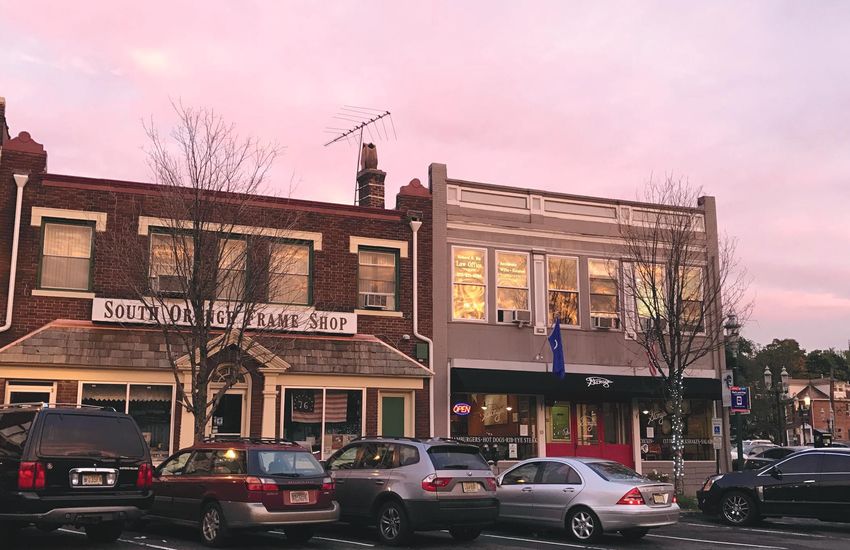
LAND USE + COMMUNITY FORM - INTRODUCTION - What is the Land Use and Community Form Element?                                                                              LAND USE + COMMUNITY FORM - INTRODUCTION - What were the major findings?

     The Process
     To prepare the LU+CF, a comprehensive analysis was undertaken over the course of multiple years. A multi-phased
     planning process was deployed to understand and evaluate the complex concerns, significant issues, and key
     opportunities affecting South Orange, surrounding land use, and community form, but also how use and form influence
     housing, jobs, economic development, community development, and environmental sustainability. The process of
     developing the Community Form and Land Use Element was predicated on the following principles from the beginning:
                                                                                                                                02
                                                                                                                                 What were the major findings?
                                                                                                                                 After significant investment in research and engagement, several key themes emerged to guide the direction
                                                                                                                                 of the Land Use + Community Form Element.

     Data-Driven                                                      Iterative                                                  It Takes a Village                                              Cut the Red Tape!
     Particularly during the early phases of the planning             Throughout the planning process, assumptions               Residents in South Orange love their community.                 Current development regulations do not go far
     process, quantitative, documentary, and geographic               were confirmed as they evolved into insights.              Many have distinctive reasons for doing so, but a deep          enough to prioritize character and often produce
     data was collected from a wide variety of sources.               Alternative approaches were vetted as they evolved         appreciation for the Village’s unique community culture         buildings that fall short of local expectations.
     Numbers were crunched. Maps were made.                           into the concepts and proposals contained below.           is something that arose time and time again. Residents          Moreover, cumbersome regulations inhibit
     Insights were absorbed. Theories were tested. The                To be both inclusive and reflective of stakeholder         celebrate the fact that South Orange is caring and              investment through outdated zoning regulations
     purpose of this work was not only to ensure policy               input, the planning process had to be iterative.           progressive, offering residents a wide spectrum of choice       and red-tape that increases time and cost. These
     recommendations were based on solid facts, but to                                                                           in terms of mobility and lifestyle. To be successful, this      outcomes hurt the Village – decisions to forgo
     help develop a better understanding of stakeholders,                                                                        Land Use + Community Form Element (and the entire               new investment, a “dumbing-down” of building
     allowing for a more targeted engagement strategy.                                                                           Master Plan for that matter) must elevate these values to       design to meet inflexible standards, or a general
                                                                      Engagement, and lots of it!                                inform local policies and regulations.                          frustration among property owners seeking to
                                                                      The public was invited to participate in outreach                                                                          make relatively simple property improvements.
     Additive, not Duplicative                                        activities and offer feedback in a variety of forms at
     This is not the first plan ever created to guide
                                                                      multiple points throughout the planning process.           It’s all about Character
                                                                      Activities were designed to be fun, inclusive, and
     future growth in South Orange. The community                     productive. Specific areas of inquiry involved the look
                                                                                                                                 There is a clear disconnect between residents’ vision           Better public places, more
     has a long history of community planning. To                                                                                for their community and the regulations put in place
     honor prior efforts and use resources efficiently,
                                                                      and feel of neighborhoods, desirable public amenities,
                                                                                                                                 to guide new development. The result has been
                                                                                                                                                                                                 smiling faces
                                                                      and housing preferences. Engagement activities
     existing plans were reviewed as a key starting                                                                              dissatisfaction with certain new development projects           In many areas of the Village, existing patterns
                                                                      aimed to promote direct and personal interaction
     point. Relevant data and concepts were identified                                                                           and conflict among members of the public who want               and current land use regulations do not advance
                                                                      with the LU+CF planning team as the plans were being
     and incorporated into the pages below. Moreover,                                                                            to see new investment and modernization, but not at             a cohesive identity throughout corridors. Public
                                                                      developed in real time. Preliminary sketches were
     particular attention was paid to ideas that were                                                                            the cost of the community’s cherished character.                realm improvements along commercial corridors
                                                                      displayed for public reaction and concepts were re-
     never implemented and recommendations that                       worked based on feedback. This process culminated in                                                                       lack a desired uniformity and, with the exception of
     didn’t produce intended results. A page of history               Charrette Week, which included a unique open-house                                                                         a few areas, streetscape and public design does not
     is worth a volume of logic!                                      design studio hosted in a donated storefront along                                                                         provide the types of amenities or accommodations
                                                                                                                                 Plan the Work, Work                                             that a walkable, social community like South
                                                                      South Orange Avenue.
                                                                                                                                 the Plan!                                                       Orange has come to expect.
     Field-Work Driven                                                                                                           The Village has invested in rather significant
     Research findings and community input were                                                                                  planning efforts over the past few decades.
     verified with real-world observations. Field-work                                                                           However, in retrospect, these efforts were not
     allowed for observation and informal discussions                                                                            incorporated into a comprehensive planning
     that ultimately painted a more complete picture                                                                             agenda that spans the terms of elected officials
     about day-to-day life in the Village, how changes                                                                           or other stakeholders. This not only creates
     are impacting residents, nagging concerns, and                                                                              skepticism among residents regarding the planning
     aspirations for the future of the community.                                                                                process, but also hinders the Village’s ability to
     Through this work, discoveries were made that                                                                               implement complex, long-term initiatives.
     could never be found in the pages of a book.

99                                                                                                                                                                                                                                                       10
LAND USE + COMMUNITY FORM - INTRODUCTION - How Do We Address These Findings?                                                                                  LAND USE + COMMUNITY FORM - INTRODUCTION - How Do We Address These Findings?

     How do we address these findings?
     The goals and objectives of this element were based on the insights and observations described above, deep
     qualitative and quantitative analysis, and an application of best practices. As will be more fully detailed at the
     conclusion of this element, the top-level goals are summarized below (spoiler alert!):

      1                                         2                                             3                                 4                                   5                                         6

     Elevate the                               Harmonize Land                               Accelerate                         Strengthen                          Nurture the                               Ensure Plan
     Quality of New                            Use + Mobility                               Reinvestment                       Neighborhoods                       Village’s Cherished                       Implementation
     Development                               In order to successfully                     Throughout the engagement          and Corridors                       Sense of                                  and Improve
     The Village needs a blueprint
                                               achieve the improvements
                                               in the day to day lived
                                                                                            process, both residents
                                                                                            and owners of commercial
                                                                                                                               South Orange is                     Community                                 Operations
     for future development that                                                                                               celebrated by residents as
                                               experience of South                          properties and small                                                   South Orange places a                     To paraphrase management
     is both comprehensive for                                                                                                 a tapestry of unique but
                                               Orange residents                             businesses detailed reasons                                            unique priority on equity,                guru Peter Drucker – plans are
     the Village and specific to                                                                                               connected neighborhoods
                                                                                            why they decided not                                                   environment, opportunity,                 only well-intentioned if they’re
     properties and buildings                                                                                                  and corridors
                                                                                            to advance certain new                                                 and access                                followed by hard work
                                                                                            investments within the Village

     Objectives                                Objectives                                   Objectives                         Objectives                          Objectives                               Objectives
     As noted, current                          Land Use policies and                       Ranging from a simple addition     Each of these geographies face      While these ideals are cooked            This element lays out an
     development regulations                    concepts must be developed in               to their home, to a storefront     unique challenges which, in turn,   into the “DNA” of this                   ambitious agenda for the
     cannot effectively guide the               harmony with improvements                   renovation, to construction of a   need to be addressed by policies    element, specific concepts and           Village to shape its future.
     type of new development                    to the Village’s transportation             new building. Their reasons are    tailored to the character of each   strategies evolved that would            As noted above, prior
     that will advance local                    infrastructure. Complementing               varied and complex. However,       specific area. This goal outlines   address these unique and                 plans have seen sporadic
     aspirations. The contents of               the recommendations                         one theme that arose was           strategies to protect residential   laudable objectives – so they            implementation, and many
     this goal lay out a strategy               put forth in the Mobility                   concerns around outdated           neighborhoods, eradicate            get their own goal!                      residents shared concerns
     for the Village to take                    Element, this goal lays out the             and cumbersome regulations,        deleterious land uses, create                                                about the administration and
     control of the aesthetics                  preliminary steps to improve                and, particularly, the excessive   opportunities to provide much                                                enforcement of land use and
     and character of new                       the design and utilization of               number of parcels rendered         needed infrastructure, and many                                              development processes. Thus,
     development.                               parking facilities, loading areas,          non-conforming by current          other components focused on                                                  this element would not be
                                                and streetscapes.                           zoning regulations and related     leveraging opportunities and                                                 complete without a discussion
                                                                                            barriers to improvement.           addressing challenges.                                                       of implementation and
                                                                                                                                                                                                            internal workflows.

11                                                                                                                                                                                                                                                12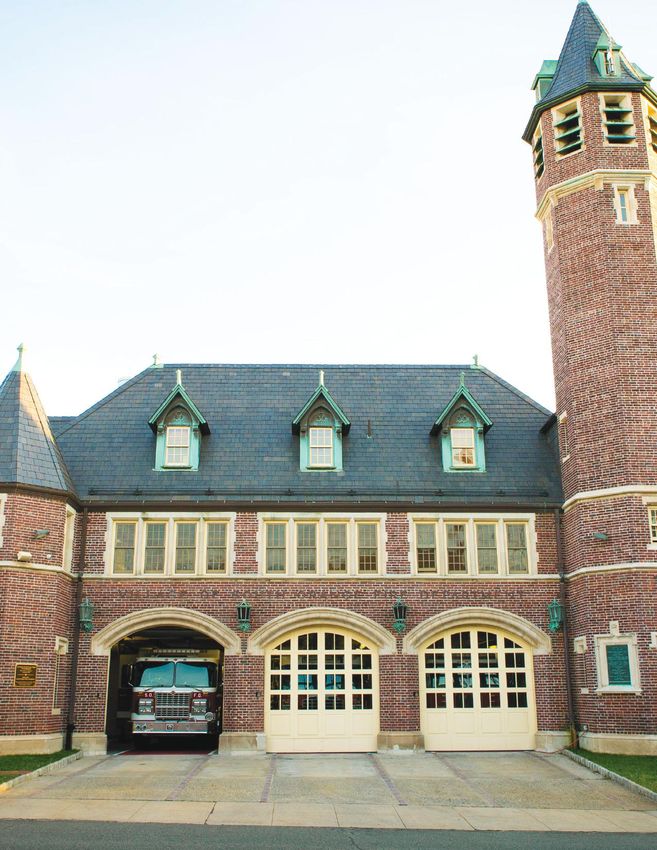
LAND USE + COMMUNITY FORM - INTRODUCTION - The Fine Print                                                            Downtown South Orange   LAND USE + COMMUNITY FORM - INTRODUCTION - The Fine Print

03   The Fine Print
     The New Jersey Municipal Land Use Law requires that all municipal master plans contain a Land Use Element
     that details “…the existing and proposed location, extent and intensity of development of land to be used in the
     future for varying types of residential, commercial, industrial, agricultural, recreational, educational and other
     public and private purposes or combination of purposes; and stating the relationship thereof to the existing
     and any proposed zone plan and zoning ordinance… including a statement of the standards of population
     density and development intensity recommended for the municipality.” (See N.J.S.A. 40:55D-28.b).

     As indicated above, the Land Use and Community Form Element is not only an important piece of local policy,
     but it also has legal significance and must meet certain statutory requirements. This Element was crafted not
     only to satisfy the obligation imposed by the New Jersey Municipal Land Use Law that a Master Plan shall
     contain a Land Use Element , but it was also written to satisfy the following requirements of a Master Plan
     Re-Examination, which municipalities are obligated to undertake every 10 years.

     These requirements include an overview of:
            The major problems and objectives relating                The specific changes recommended for the
      1     to land development in the municipality at
                                                                 4    master plan or development regulations, if
            the time of the adoption of the last                      any, including underlying objectives, policies
            re-examination report.                                    and standards, or whether a new plan or
                                                                      regulations should be prepared.
            The extent to which such problems and
     2      objectives have been reduced or have                      The recommendations of the planning
                                                                 5    board concerning the incorporation of
            increased subsequent to such date.
                                                                      redevelopment plans adopted pursuant to
            The extent to which there have been                       the “Local Redevelopment and Housing Law,”
     3      significant changes in the assumptions,                   P.L.1992, c.79 (C.40A:12A-1 et al.) into the land
            policies, and objectives forming the basis for            use plan element of the municipal master
            the master plan or development regulations                plan, and recommended changes, if any, in
            as last revised, with particular regard to the            the local development regulations necessary
            density and distribution of population and                to effectuate the redevelopment plans of the
            land uses, housing conditions, circulation,               municipality. L.1975,c.291,s.76; amended 1980,
            conservation of natural resources, energy                 c.146, s.6; 1985, c.516, s.18; 1987, c.102, s.29;
            conservation, collection, disposition, and                1992, c.79, s.50; 2001, c.342, s.9.
            recycling of designated recyclable materials,
            and changes in State, county, and municipal
            policies and objectives.

     While the following pages are not organized around the sections specific to a Re-Examination Report, the content
     exceeds these minimum standards. To that end, please see the Appendix section, located at the end of the Master
     Plan, for a memorandum that details how specific components of the content contained herein satisfied each of
     the five obligations listed above.
13
13                                                                                                                                                                                                            14
LAND USE + COMMUNITY FORM - EXISTING CONDITIONS + OBSERVATIONS                   LAND USE + COMMUNITY FORM - EXISTING CONDITIONS + OBSERVATIONS- Historic Form + Organizatinal Features

                                                                      01
                                                                       Historic Form + Organizational Features
                                                                       It is essential to study the historical form, current physical conditions, development trends, and administrative
                                                                       efforts when considering the appropriate direction for future land use and community form policies. Future
                                                                       development will be influenced not only by these factors, but also by private interests and other macro-level
                                                                       conditions, such as economic and market trends. As a guide for future of South Orange Village, the Master Plan
                                                                       will recommend changes to current practices and seek to steer private development in accordance with the vision
                                                                       of the community. Analyzing existing conditions provides a peek into the factors that led to the current physical
                                                                       environment and potential obstacles and opportunities for the future.

                                                                       A cursory study of historic maps illustrates what is still evident today: South Orange Village has generally grown
                                                                       around the north-south axis of the Rahway River and railroad and the east-west axis of South Orange Avenue.
                                                                       For obvious reasons, the intersection of the two became the Village origin point in downtown South Orange.
                                                                       Other important streets lead from this center point like spokes. Irvington Avenue, Scotland Road, Valley Street,
                                                                       Ridgewood Road, Maplewood Avenue, and Centre Street directly and indirectly link South Orange Village to
                                                                       surrounding communities and neighborhoods beyond the municipal boundary.

                                                                       Seton Hall University emphasizes the break between development north and south of South Orange Avenue and
                                                                       Irvington Avenue, as its compact campus nestles into the wedge between the two important corridors. The area

                       Existing
                                                                       west of Ridgewood Road to the South Mountain Reservation was still largely undeveloped as late as 1912. The
                                                                       topography, passage of time, and neighborhood planning practices resulted in an urban form different from the
                                                                       older parts of South Orange in the valley below.

                       Conditions +
                       Observations

15
15                                                                                                                                                                                             16
LAND USE + COMMUNITY FORM - EXISTING CONDITIONS + OBSERVATIONS- Historic Form + Organizatinal Features                 LAND USE + COMMUNITY FORM - EXISTING CONDITIONS + OBSERVATIONS- Historic Form + Organizatinal Features

     Several key features shaped the development patterns of the Village over time and will continue to influence the
     location of future development, regardless of its form and intensity. Some of key organizing features of South
     Orange’s community form are described below. The following pages examine how the features below have
                                                                                                                                              Organizational Features Diagram
     shaped the development patterns of South Orange. This analysis of existing conditions was is organized around
     the concept that the characteristics of developed places can be visualized as a series of layers. Through this lens,
     planners and citizens are reminded where their energy should be dedicated, given than some features are largely
     permanent (i.e. mountains) while others are relatively more flexible (i.e. buildings).

                 East Branch of the Rahway River
                 The river and its associated valley acts as a central spine to the community. Terrain quickly
                 ascends to the north-west, toward South Mountain Reservation and more gradually to the
                 southeast. This terrain and the path of the river have influenced block layout as well as the
                 layout of the street grid.

                 Railroad and South Orange Station
                 The railroad and, particularly, South Orange Station serves as the Downtown anchor. Express trains
                 into New York City from this station have made South Orange a desirable “bedroom community.

                 Corridors
                 Primary corridors South Orange Avenue, Valley Street, and Irvington Avenue extend from
                 Downtown like spokes. Secondary corridors Scotland Road, Wyoming, Ridgewood, and Centre
                 connect the Village to surrounding areas.

                 Open Space and Parks
                 The preservation of open space along the Rahway River, subsequent public facilities, and
                 continued efforts to enhance these spaces creates a central defining asset that connects
                 neighborhoods to each other and the amenities of the downtown.

                 Activity Nodes
                                                                                                                            Open Space and Parks              Railroad
                 In addition to downtown, nodes of activity along corridors have been historical multi-functional
                 centers serving adjacent neighborhoods.                                                                    Major Corridors                   Activity Nodes

                                                                                                                            Rahway River

17                                                                                                                                                                                                                                   18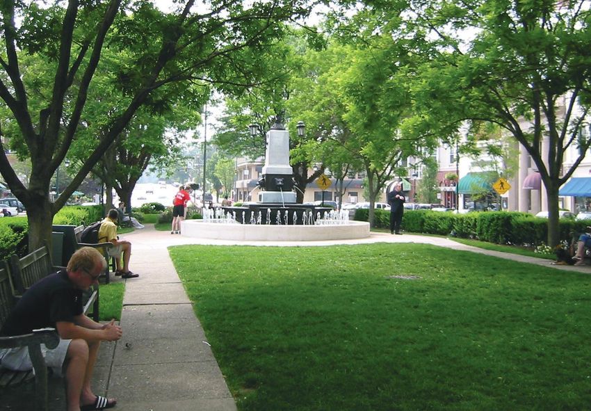
LAND USE + COMMUNITY FORM - EXISTING CONDITIONS + OBSERVATIONS- Historic Form + Organizatinal Features LAND USE + COMMUNITY FORM - EXISTING CONDITIONS + OBSERVATIONS- Historic Form + Organizatinal Features
Natural Features Steep Slopes
Steep slopes can naturally constrain development. Slopes in excess of 20 percent are considered “steep” while
Topography (the shape of land surfaces) and hydrology (the location and nature of water bodies and courses) those in excess of 25 percent are commonly defined as “extremely steep.” Steep slopes can necessitate the
have perhaps the most significant impact on development while also being the least flexible. As such, these construction of deeper foundations and additional grading, generally lengthening the time needed to survey for
should be considered the most fundamental and immutable existing conditions impacting future land use and build a structure. Development along steep slopes can also lead to erosion and make a community more
planning in the Village. prone to flooding. NJ DEP guidelines recommend regulating and possibly prohibiting development on land near
wetlands that has a slope in excess of 10 percent.
The Lay of the Land
South Orange’s topography has contributed greatly to its existing development pattern. The community straddles Steep slopes are most prominent in Upper Wyoming, where slopes surpass 25 percent in a few locations. They
the valley along both sides of the East Branch of the Rahway River. A significant portion of the valley has been also exist near the common open space controlled by the Manors of South Mountain Association, a small portion
preserved thanks to the early 20th century preservation efforts of the Meadowland Society. East of the river, the of which is defined as wetlands. Steep slopes also exist in South Mountain, where the steepest slopes in the
topography rises rather quickly and then more gently toward a knoll near Seton Hall University. West of the river, neighborhood are dedicated for public uses;, and the Rahway River Plan recommends setting aside this area for
the topography rises quickly then very steeply toward the South Mountain Reservation – part of the Watchung conservation. Lower Wyoming and Newstead also contain steep slopes.
Mountains. The topography levels off quickly at the edge of the Newstead neighborhood and is fairly gentle to
the western boundary of the community. Traversing the steep topography of South Mountain, then the valley,
and then rising again to the east likely necessitated the unique geometry of the community’s main artery, South
Slope of Terrain (%)
Orange Avenue.
Slope of Terrain (%) Jes
s ic a
Topographic Map from Common
Wa
y
Ground Baseline Report
Lo
ng
v ie
w
Ave
Rd
Ho
ing
ski
St
er R
Á
yom
d
rk
Cla
NW
r
Rd
Tee
nd
Rd
ov
la
Gr
ot
t
ie w
Dr
eS
Rd
Sc
ing
nv
ntr
d
Tu
oo
rre
Gle
Slope of Terrain (%)
rd
Ce
ll A
ew
Ha
ve
e
Av
id g
Jes
s ic a
se
NR
Wa
y
Vo
S Orange Ave
Lo
ng
Á
v ie
Slope Le w
Ave
Rd
no
l
t P
xHA 4th
ing
osk
Var
Sd
veier R St
rkar
< 5% Á s
yom
N
d ity
ClaW
Rd
NW
r
5 - 10%
Rd
Te
St
e
nd
Rd
ov
la
ry
10 - 15% Landmarks
Gr
ot
t
ie w
lle
eS
Rd
Sc
D
inga
nv
ntr
rd V
t
d
tS
Tu
oo
15 - 20% rre
Gle
Ce
Á Train Stations ll A
c
ew
Ha
pe
ve
e
0 0.2 0.4 0.6 0.8
Av
id g
os
20% < Train Line Miles
se
NR
Pr
Vo
S Orange Ave
Á Source: NJ DEP, Topology
Slope Le
no
Pl
xA 4th Var
d
ve St
ar
< 5% s
N
ity
W
Rd
5 - 10%
ySt
South Orange Village Boundary 20ft Contours < 5% 10 - 15% Landmarks
10 - 15% 20% <
lle
Va
t
tS
15 - 20% Á Train Stations
c
pe
0 0.2 0.4 0.6 0.8
Parcels
os
5 -10% 20% < 15 -Train
25% Line Miles
Pr
Source: NJ DEP, Topology
19 20LAND USE + COMMUNITY FORM - EXISTING CONDITIONS + OBSERVATIONS- Historic Form + Organizatinal Features LAND USE + COMMUNITY FORM - EXISTING CONDITIONS + OBSERVATIONS- Historic Form + Organizatinal Features
Water Bodies, Flood Prone Areas, + Wetlands
Flood Areas and Wetlands
An analysis of South Orange’s hydrology patterns requires a detailed assessment of the East Branch of the Rahway Flood Areas and Wetlands
River. The branch essentially bisects the community north to south and is the most important defining feature of Dr Bla
n tain n ch
the Village. According to the East Branch of the Rahway River Master Plan, as the community grew, the Rahway Mou ard
Rd
River corridor attracted industrial development, but was also used to dump waste. Members of the South Orange Lo
n gv
d
i ew
dR
community attempted to slow or stop development along the river corridor over the course of the late 19th and Rd
Pl
Bren
oo
two
k
od D
ar
ew
r
early 20th centuries. The Meadowland Society began acquiring land along the river in the early 20th century and
Cl
Rd
dg
Á
E
Ri
d
la n
sold it back to the South Orange Village. The sales included restrictions to ensure the river corridor would be
N
t
kS
t
Sc o
Hi
ar
preserved for open space and recreational purposes, which became the foundation for the recreational spaces gh
Cl
la n Wa
Dr
d r wi
Rd ck
ir
still existing present today. Despite the efforts of the Meadowland Society and the subsequent park projects, the
e
Irv Av
ve
Sp
ing e
Flood Areas and Wetlands
gA
Me
Dr
Ti Av
e
llo ad e
Av
in
U.S. Army Corps of Engineers constructed flood control projects in the 1970’s that channelized portions of the
ing
u St
m
Fo Rd
se
yo
rd
st
Vo
Ha
d
e
W
river in the heart of the Village. These manmade structures significantly altered the natural features of the river,
t
rC
nd R
Dr
eS
n tain
Bla Tu
N
t Mou
n ch rr e
d
ard ll A
n tr
aR
Rd ve
Holla
limited opportunities for access and enjoyment, and changed the River’s character, particularly downtown. Some
Ce
nd
Lo
W n gv
En
Ry
d
i ew
d
dR
areas of floodway and floodplain still exist, but primarily remain undeveloped and are part of current or planned Rd Rd Á
Pl
Bren
S Ora ng
oo
two
k
od D e Ave
ar
ew
e
r 2n
Cl
Av
d
open space areas. d
dg
dR
Á
E
St
S
Ri
on
St
la n
N
lt
t
re
k lS
Wa
Le
t
Sc o
lda rP
nt
no Hi
gh
Ce
x
t
Pl
Wa
Wetlands, defined as land saturated by ground or surface water, help manage stormwater and mitigate flooding.
aCr
tS
Av la n
Dr
r
St
wi
W
d
n
e
c
Rd ck
ir
lto
e
pe
Irv
rle y
Av
Pr Ave
Sp
ing e
Mi
Me
Additionally, they tend to support rich ecosystems that sustain a diverse mix of plant and animal species. Given
os
Av
aDl
Ti
e
g
llo ad e
Av
Legend
in
ingV
u St
m
N
Fo Rd
se
M
yo
rd
st on er
Vo
these qualities, communities are urged to conserve wetlands where possible. Environmental regulations prohibit
Ha
d
e
W
rT
t
rC
nd R
t
eS
Tu
ag
N
150' Max Buffer t e rr e
d
Ga ue Ed
ll A
n tr
aR
ve
Holla
Hix rf i Pl
Ce
new development in close proximity to wetlands. For example, the New Jersey Department of Environmental e ld
nd
Wetlands on
Pl
W
En
Ry
d Pl
Rd Á S Oran ge
Protection requires a buffer typically ranging between 50-150FT, depending on the type of wetland in question. Floodway Av e
e
2n
Av
d St
S
0 0.25 0.5 0.75 1 Source: NJ DEP, FEMA;
on
100-Yr Floodplain
St
lt
re
Wa
Le
Pl
Miles Topology
nt
no
d
Wetlands occupy a small but important portion of the Village’s land, 14.95 acres in all. These wetlands are
Ce
x
t
Pl
ar
tS
Av
St
W
n
e
ec
lto
le y
sp
Mi
l
located almost entirely within parkland and places reserved for open space. These areas include Cameron
Va
o
Legend
Pr
N
M
er
150’ Max Buffer Floodway
150' Max Buffer
on
t ag e rT
Field, Grove Park, and Waterlands Park, as well as the open space component of the Manors at South Mountain Wetlands
Hix
on
Pl
Ga
rf i
e ld
Pl
ue
Pl
Ed
planned development. Some existing development exists close to wetlands in South Orange, most of which are Wetland Floodway 100-Yr
100-Yr Floodplain 0 0.25 0.5 0.75 1 Source: NJ DEP, FEMA;
longstanding residential neighbors. However, certain light industrial uses along Lackawanna Place are situated Floodplain Miles Topology
relatively close to existing wetlands.
21
21 22
22LAND USE + COMMUNITY FORM - EXISTING CONDITIONS + OBSERVATIONS- Historic Form + Organizatinal Features LAND USE + COMMUNITY FORM - EXISTING CONDITIONS + OBSERVATIONS- Historic Form + Organizatinal Features
Commuter Rail + Regional Corridors From a land use perspective, the train station drives the highest levels of daily activity in the Village, but the raised
rail line that serves the station has created a number of challenges. For example, the several streets extending
Historically, regional transportation networks have profoundly impacted on the character and location of from Valley Street “dead end” along the east side of the rail embankment. This condition reduces the access to
development, and South Orange is no exception. Development in the Village is generally oriented around the and livability to of these virtually hidden areas, where industrial uses once proliferated, and out-of-sight buildings
north-south axis of the railroad (and Rahway River) and the east-west axis of South Orange Avenue. Within these are unkept and decaying. These dead-ends also represent significant bottlenecks to circulation patterns. For
high-level organizing features that connect South Orange to the broader region, local transportation routes also example, Third Street, which experiences severe congestion during peak hours, is the only rail crossing exists
evolved around the developability of land, which in turn defined the size and shape of properties upon which between South Orange Avenue and the municipal border with Maplewood, impeding walkability and overall east-
homes, businesses, and other uses were constructed over time. west traffic patterns.
The rhythms of daily life in South Orange also drive economic and cultural activity toward transportation assets.
For example, the largest and most obvious node of activity is downtown South Orange, which is anchored by the
train station and bisected by South Orange Avenue and the East Branch of the Rahway River. In essence, all roads
in South Orange lead to the downtown. Activity stretches along the main corridors, such as Valley Street, South
Orange Avenue, and Irvington Avenue, where commercial uses create neighborhood anchors and amenities.
Major Corridors
As this plan travels down through the physical “layers” of the Village, the following pages detail the transportation
assets in South Orange and discuss how they impact land use dynamics. South Orange Village contains several important arterial roads that provide connectivity, accessibility, and mobility
within the municipality. Throughout the Village, there are four county roads that are maintained by Essex County:
South Orange Avenue, Valley Street, Irvington Avenue, and Wyoming Avenue. These county roads serve as major
corridors within the Village and are vital links to neighboring municipalities, including the City of Newark. Additionally,
Transit Access and Rail Infrastructure they provide direct access to the South Orange Train Station and link commuters to the Garden State Parkway and
New Jersey Interstates I-280 and I-78. Regarding development intensity and land use, South Orange Avenue, Valley
This Master Plan is being written amidst the COVID-19 pandemic and recognizes that these conditions may not accurately Street, and Irvington Avenue have the greatest capacity for future investment, particularly within and to the south
represent the patterns as of date or in the near future.
and east of the Village center. The following is a brief discussion of the county roads and their purposes:
South Orange has two railroad stations that provide convenient access to New York and other regional
destinations via the NJ Transit Morristown Line and Gladstone Branch. The downtown station, with Midtown
Direct express train service, is in the Village’s core, and easily reached by bicycle or foot. According to 2018 data,
South Orange Avenue Irvington Avenue
the main South Orange station has the tenth most weekday trips among all New Jersey Transit railroad stops. (County Route 510) is the main arterial road within the (County Route 665) also connects to South Orange
Village and carries a high volume of traffic. South Orange Avenue and provides a link to Irvington Township.
Residents can also access train service to New York from the Mountain Station. Though service is less frequent, Avenue connects surrounding areas to downtown
many residents rely on it to travel to and from New York. The station is within a short walk or bicycle ride for South Orange and the train station, while also providing
residents who live in the West Montrose and Montrose Park neighborhoods. accessibility to Seton Hall University, the Garden State Wyoming Avenue
The map below illustrates the downtown station’s relative accessibility. A quarter mile walkshed encompasses Parkway, and the City of Newark. (County Route 577) runs north and south within
most of the downtown, as well as large multifamily developments such as Gaslight Commons, Village Mews, and the Village and also connects to South Orange
the apartments on Vose Avenue. Many train commuters walk to the train stations from residential neighborhoods Avenue. This road provides a link to Millburn
Valley Street Township and West Orange Township.
outside the quarter-mile walkshed. A total of 905 acres, or almost 50 percent of the Village’s land area is within a
(County Route 638) directly intersects with South
half-mile walk of a railroad station.
Orange Avenue and links to the City of Orange and
The presence of commuter rail service, and the infrastructure that enables it, has profoundly impacted the Maplewood Township. Valley Street also provides
evolution of the community. Commuter rail service has provided the Village access to the incredible wealth and close access to New Jersey Interstates I-280 and I-78.
opportunity in New York City – the world’s richest city, with economic output that rivals that of many developed
nations. This direct connection has conferred incredible wealth upon the Village, through the success of its
residents. Today, transit access continues to drive the value of single-family homes and rents, resulting in relatively
high median incomes and education levels.
For a full description of regional roadways and corresponding maps, see Section XX of the Mobility Element.
23 24LAND USE + COMMUNITY FORM - EXISTING CONDITIONS + OBSERVATIONS- Historic Form + Organizatinal Features LAND USE + COMMUNITY FORM - EXISTING CONDITIONS + OBSERVATIONS- Historic Form + Organizatinal Features
Streets, Blocks + Buildings Buildings
The Building Footprint diagram below depicts the location of buildings and similar structures in grey and the
Another level down on the list of physical “layers” are local street networks and the blocks of land they define,
ground plane in white. This diagram illustrates the basic relationship between the mass of vertical structures
which are ultimately divided into lots with unique land uses. This section further defines key parameters of
and the areas around them. Such analysis can be useful to determine the appropriate footprint of development
development and examines how the alignment of streets inform a deeper understanding of how properties got
intended to be compatible with its surrounding context. Much of the community has a pattern of smaller building
their shape and the unique challenges that these external features impose on the properties they create.
footprints with generous open space surrounding each building. This primarily includes single-family detached
housing with yards, as well as some larger civic and institutional buildings, and a few multi-family developments.
Streets + Blocks
Larger footprint buildings are limited to a small cluster on the eastern boundary (Seton Hall) and within and
The Village of South Orange enjoys a well-connected network of streets. As discussed above, the main corridors around the downtown. As expected, many downtown buildings occupy a majority of their lots and have little to no
are South Orange Avenue, Valley Street and, Irvington Avenue. distance between adjacent buildings and minimal or non-existent front yard or rear yard setbacks. These building,
form a fairly consistent edge along downtown streets. A present – —but less consistent – —pattern of “street
South Orange Avenue often functions as the central division between neighborhoods to the north and south of wall” exists along Valley Street and Irvington Avenue.
it and also happens to be one of only four east-west connections across the Rahway River and the rail line. This
places a lot of pressure on Montrose Avenue, Mead Street, and Third Street to serve as east-west connectors.
Other important corridors with lower intensity include Wyoming, Ridgewood/Walton, Scotland/Valley, and Centre
Street, which run primarily north-south, and are important connections between South Orange and surrounding
Buildings
communities.
In certain instances, there are dead-end streets, but overall, the informal grid of streets provides multiple ways to
get from one part of the community to the other.
For full description of street networks, types of roads, and corresponding maps, see Section XX of the Mobility Element.
Street Networks
South Orange Village Boundary Essex Co. Buildings
and Structures
South Orange Village Buildings
and Structures
25 26LAND USE + COMMUNITY FORM - EXISTING CONDITIONS + OBSERVATIONS- Existing Land Uses LAND USE + COMMUNITY FORM - EXISTING CONDITIONS + OBSERVATIONS- Existing Land Uses
02
Key Land Use Areas
The Village is comprised of a diverse set of land use areas that reflect many of the characteristics and influences
already discussed above – topography, historic development patterns, existing transportation routes, and similar
Existing Land Uses + Regulations features. The following summaries are intended to highlight the key attributes that exist in each land use area and
must be considered as part of any future policy recommendations
A cursory review of current land use provides important insight into the land use patterns that have developed.
The predominant land use pattern is single-family detached housing, while the majority of the Village’s
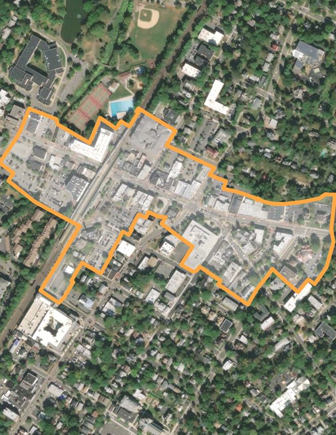
commercial and non-residential uses lie around the Downtown and near the intersection of South Orange Commercial and Mixed-Use Districts
Avenue and the Railroad/River. Commercial and other non-residential uses extend along South Orange Avenue South Orange contains three distinct commercial and mixed-use areas which, as noted above, are largely
toward Grove Park, along Valley Street, and portions of Irvington Avenue. Higher density residential areas organized around key regional corridors: the Village Center, at the geographic center of the community and
are primarily along these corridors. This land use pattern indicates a more intense pattern of development largely organized around South Orange Avenue; Seton Village, along the Irvington Avenue corridor; and the Valley
emanating from downtown toward the southeast, but the intensity transitions quickly to the predominant Street commercial district. Village Center is the most walkable of the three commercial areas and is home to 140
shops, NJ Transit’s South Orange Station, and the SOPAC cultural facility (more on SOPAC below). Seton Hall
single-family pattern. A large swath of open space and civic use straddles the Rahway River emphasizing the
University, a private university with an enrollment of approximately 10,000 students, is located just outside the
natural separation between the east and west portions of the community. downtown. Despite the presence of high-income households, both in South Orange and the surrounding region,
some local businesses struggle to thrive. Additionally, the South Orange Village Center Alliance (“SOVCA”) has
had limited success developing a retail portfolio (either through attraction or local development) that leverages
Existing Land Uses the region’s wealth. In 2014, SOVCA commissioned the JGSC group to prepare a retail analysis of the downtown.
The JGSC report emphasized a targeted recruitment strategy as another way to bolster the district, but also
recognized the lack of pedestrian traffic, particularly during the daytime.
Residential Neighborhoods
Residential neighborhoods flank the mixed-use commercial corridors, with some high-density urban building types
and apartment buildings in and adjacent to the Village Center, which, in some cases, transition to townhomes or
residential-style offices and then finally to single-family homes in neighborhood interiors and along residential-
only corridors such as Scotland Road, Wyoming Avenue and, Ridgewood Avenue. Some unique conditions
observed in South Orange residential neighborhoods include: a relatively significant amount of non-profit housing
developed for both senior citizens and developmentally disabled residents; informal student housing and similar
facilities related to the presence of Seton Hall University; and the existence of vast gilded- age mansions, which
are costly to maintain and may not appeal to future generations of homeowners. Generally, the Village’s assets of
a walkable downtown, incredible community culture, an excellent open space network, and an easy commute to
S Ora
nge A
ve
New York City have made South Orange an attractive place to live for individuals from many different walks of life.
These are unique assets in the region, and the Village’s attractiveness as a place to live is unlikely to change.
S Orange Ave
e
e ge Av
ge Av S Oran
S Oran
S Orange Ave
S Orange Ave
Industrial Uses
Industrial activity in South Orange has been limited and has been traditionally located close to the railroad right-
of-way in the community’s southernmost portion. The railroad and industrial uses like the lumberyard and the
Delaware and Lackawanna pumphouse were located here to take advantage of the current of the Rahway River.
This industry influenced later development, polluting the land and making it less attractive for residential and
commercial development. At present, light industry is along Lackawanna Place, which runs parallel to the railroad
to its east. The industrial uses here include garages, auto body shops, and waste facilities, among other types of
South Orange Village Boundary Residential - Medium Density University light industry. Nearby, light industrial uses still operate on several properties at the end of Church Street. A few
Parcels Residential - Low Density Railroad
garages on Irvington Avenue can also be classified as industrial land uses.
Natural Area Residential - Large Estates Water-bodies
Recreation Commercial Vacant Land
Residential - High Density Institutional
27 28LAND USE + COMMUNITY FORM - EXISTING CONDITIONS + OBSERVATIONS- Existing Land Uses LAND USE + COMMUNITY FORM - EXISTING CONDITIONS + OBSERVATIONS- Existing Land Uses
Public / Civic Uses Community Facilities
The Community Facilities map above shows the location of institutions and services throughout South Orange.
The location of community facilities has a great impact on the location and intensity of future development. As
established above, a series of parks, open space, and recreational facilities are clustered in the center of the Village Community Facilities EMS
along the Rahway River corridor. The river, railroad, and parks, combined with the downtown, reinforce this area
as the heart of the community. Fire Station
Library
Seton Hall University
The main campus of Seton Hall University is the most prominent privately-owned facility shaping land Police Station
development in South Orange. The 57-acre campus is bounded by South Orange Avenue, Ward Place, Wildey
Place, and the boundary with Newark. The campus contrasts with the surrounding residential streetscapes, most Village Hall
notably on South Orange Avenue where the main gate to the campus is located. The campus is fenced off from
the Village along the entirety of this street frontage, discouraging street activity along South Orange Avenue. Public Schools
Residents frequently cited these features as both a physical and symbolic barrier to their envisioned town/gown
relationship. Many cite this as a missed opportunity for economic development in the downtown and a constraint Public Works
on the students’ experience.
Seton Hall operates several off-campus offices along South Orange Avenue and Centre Street. These uses have
limited landscaping and expansive parking areas, making them far different in character from the surrounding
residential neighborhoods as well as being more significant traffic generators. The University also operates two
off-campus housing structures, Turrell Manor and Ora Manor. While the former is located close to the main
campus gate, the latter is on Valley Street. Students also live in private residences off campus. Some live with
friends while others live in houses associated with athletics teams and other university-affiliated groups. There
are several Greek houses off campus, mostly in the Seton Village neighborhood. The student population’s housing
needs has resulted in some residential property owners adapting their single-family residential properties to
provide student housing. In one particular case, a former single-family home was converted to accommodate Village Hall
approximately ten University students. Several neighbors have complained of illegal conversions and over-
Traditionally, municipal government operated out of the historic Village Hall, located at the northeast corner of
crowding. The Village is taking proactive steps to enforce applicable regulations while simultaneously proactively
seeking to accommodate students in appropriate locations with suitable accommodations. Scotland Road and South Orange Avenue. Built in 1894, the 125+ year old structure required significant and costly
repairs. After much debate, the Village ultimately decided in 2015 to sell the structure to a private developer
While the university is eager to expand, space on campus is extremely limited. While some of the University’s
who is currently converting the building to a restaurant and event venue. Since then, the Village reestablished
student population will go on to attend classes at the Nutley campus, overall Undergraduate enrollment has
increased recently, rising from approximately 5,200 students in 2009 to about 6,100 students in the fall of 2019. its operation in an office building across the street at 76 South Orange Avenue, where administrative offices and
Employment on campus, however, has remained steady at approximately 1,750 employees. informal meeting spaces are located.
Public Schools
Vacant Land Four of the eleven public schools that comprise the joint South Orange – Maplewood School District are
South Orange is essentially built-out with few undeveloped parcels. A handful of undeveloped lots exist, but distributed throughout the community except for the southeast quadrant, providing schools within reasonable
otherwise, development is limited to already developed sites. A modest number of parcels are listed as vacant walking distance of many residential neighborhoods. However, playgrounds, while dispersed, are a far walk for
in the assessor data. Condominiums account for some of these parcels, but many may be sites well-suited for from many neighborhoods.
development. Vacant parcels are located on most of the arterial corridors in the Village including South Orange,
Irvington, and Wyoming Avenues. Church Street and the northern part of Montrose Park also have groupings of
such parcels.
29
29 30
30LAND USE + COMMUNITY FORM - EXISTING CONDITIONS + OBSERVATIONS- Existing Land Uses LAND USE + COMMUNITY FORM - EXISTING CONDITIONS + OBSERVATIONS- Existing Land Uses
Public Library
Open Space + Natural Resources
The public library’s central location on Scotland Road, less than two blocks north of South Orange Avenue,
South Orange has 86.328 acres of protected open and recreational space. Most of these parks are centrally
offers convenient access for Village residents and strengthens the connection of the central business districts
located along the Rahway River corridor, providing convenient access to many schools, residential neighborhoods,
to the residential areas to its north and east. The original historic structure built in 1896 still stands, along with
and the downtown. Other parks service specific neighborhoods and are dispersed throughout the community.
its contemporary counterpart built in 1968. Their architecture provides visual cues that establish the boundaries
Additionally, the Village shares a border with the South Mountain Reservation, a significant Essex County nature
of the public serving land uses in the area with complementary design features to the nearby post office, train
reserve with several recreational amenities. Overall, parks are well utilized, but certain sections of the Village
station, and Baird Community Center.
lack easy connectivity for pedestrians and bikes to/from neighborhoods. Open space within the downtown,
including Spiotta Park, can be further improved with enhanced programming and management. The Village owns
South Orange’s open spaces apart from a ten-acre green space at the former Kiernan’s Quarry site, which was
Public Works redeveloped into a planned residential development.
The Village’s public works facility is also centrally located amidst the park lands of the Public Use/Open Space zone
in the southern portion of the Rahway River corridor. The facility is accessible by Walton Avenue and contains The Village’s position along either side of the Rahway River make the Riverit a defining characteristic of South
offices, maintenance equipment and vehicles, as well as a recycling depot. As parts of the facility lie within the Orange. In addition to its intrinsic value for passive recreation and wildlife habitat, the protection of its riparian
100-year floodplain, consideration has been given to consolidating or relocating these operations to prevent areas present opportunities to create a complete greenway, or trail system, through the Village core to downtown
pollution to the Rahway River, damages to critical equipment and to allow more of this land to be used for public Maplewood and beyond, as envisioned in the Rahway River Master Plan.
open space.
The Baird
Open Space + Natural Resources
The Baird, center for the South Orange Department of Recreation and Cultural Affairs, is a recreational hub as
well as an arts destination for the whole family. The century old Tudor-esque building in Meadowland Park houses
the Administrative offices for the Parking Authority and the Department of Recreation and Community Affairs.
While the facility is currently undergoing significant renovation and repair, the Baird is home to several programs
and services for the arts, education and culture.
Public Safety
Most of the Village’s public safety facilities are located near the Village core, with the South Orange Rescue Squad
and historic South Orange Fire House along Sloan Street, near the downtown NJ Transit station. The South
Orange Police Department is further east along South Orange Avenue, just outside the principal commercial
area and before the start of the Montrose Park neighborhood. The central location of these facilities provides S Ora
nge Av
e
for prompt response times for first responders to the various parts of the Village. Conversely, as discussed
within the Mobility Element of this plan, their locations also come with the challenges of heavy traffic around the S Orange Ave
train station and surrounding developments in the central business districts. A heavy snowstorm that made the
western portions of the Village at higher elevations temporarily inaccessible from the Village Center revealed the
need for a second fire house, which is currently located at the end of Crest Drive, within the RA-100 zone of the
Newstead neighborhood
SOPAC
The South Orange Performing Arts Center (SOPAC) is at 1 SOPAC Way, next to the South Orange station. The
performance venue is a 415-seat proscenium theater, with a five-screen movie theater, and a dance studio/rental
space in the same complex. SOPAC presents music, family, dance, theater, and comedy programs throughout the
year. The plans for SOPAC were first conceived in the mid-1990s as part of an effort by the Village to develop the
downtown area, and following Seton Hall’s partnership with SOPAC, construction commenced in August 2004
and the complex opened in November 2006 to the general public. Since the Village vacated Village Hall in 2015
to make way for redevelopment, SOPAC served as the general venue for public hearings of the Village Trustees, South Orange Village Boundary Parks Schools
Planning Board, and Zoning Board. Parcels Community Playfields
31 32LAND USE + COMMUNITY FORM - EXISTING CONDITIONS + OBSERVATIONS- Existing Land Uses LAND USE + COMMUNITY FORM - EXISTING CONDITIONS + OBSERVATIONS- Existing Land Uses
By the Numbers
South Orange encompasses 1,821 acres. The parcel base is comprised largely of one-to-four family residential uses,
which occupy 87.6% of parcels in the Village. One-to-four family residential uses constitute a smaller percentage
of total land area, representing 65.7% of assessed acreage in the Village. A sizable share, 25.4%, of the Village’s land
is used by tax-exempt institutions like Seton Hall, public property, and places of worship.
TYPE OF % OF VILLAGE % OF VILLAGE ASSESSED % OF VILLAGE TYPE OF % OF VILLAGE % OF VILLAGE ASSESSED % OF VILLAGE
PARCELS PARCELS
LAND USE PARCELS ACREAGE VALUATION VALUATION LAND USE PARCELS ACREAGE VALUATION VALUATION
1, Vacant 196 3.93% 6.27% $19,272,300 0.52% 15D, Church + 0.96% 1.21% $101,876,600 2.75%
48
Charitable Property
2, 1-4 Family 87.61% 65.66% $2,437,169,900 65.82% 15E,
4364 0 0.00% 0.00% $0 0.00%
Residential Cemeteries
3A, Farm 15F, Other Tax-
(Regular) 0 0.00% 0.00% $0 0.00% 40 0.80% 15.92% $179,949,200 4.86%
Exempt
3B, Farm
(Qualified) 0 0.00% 0.00% $0 0.00% Total 4981 100.00% 100.00% $3,702,598,737 100.00%
4A,
Commercial 175 3.51% 2.09% $187,813,100 5.07%
4B,
Industrial 6 0.12% 0.09% $4,089,400 0.11%
4C, 5+ Family
Residential 26 0.52% 0.48% $76,575,100 2.07%
5A, Class I
Railroad 8 0.16% 0.00% $0 0.00%
5B Class II
Railroad 0 0.00% 0.00% $0 0.00%
6A, Telephone 1 0.02% 0.00% $5,070,537 0.14%
6B, Petroleum 0 0.00% 0.00% $0 0.00%
Refinery
15A, Public 10 0.20% 0.89% $62,924,300 1.70%
School
15B, Other 42 0.84% 3.32% $579,670,600 15.66%
School
15C, Public 65 1.30% 4.08% $48,187,700 1.30%
Property
33 34LAND USE + COMMUNITY FORM - EXISTING CONDITIONS + OBSERVATIONS- Existing Land Uses LAND USE + COMMUNITY FORM - EXISTING CONDITIONS + OBSERVATIONS- Existing Land Uses
Zoning Districts Residential Districts: Residence ‘A’: Single-Family
The following overview of the existing zoning is intended to catalog, and in some cases provide insights into, what Detached single-family residential use is the only permitted use in the four Residence ‘A’ districts. The bulk standards in
development is currently possible within the Village. While these uses and bulk standards are generally a reflection these zones promote suburban development patterns. Minimum lot sizes range from 5,000 to 10,000 SF while widths
of what exists on the ground today, characterizing these zones is critical to understanding whether and where range from 90 to 175 feet. The RA-100 district has a maximum impervious coverage of 30 percent, while the others
permit a maximum of 40 percent.
desired uses and development patterns are impeded by the Village’s zoning code.
The RA-100 zone covers the neighborhoods north of South Orange Avenue and west of North Ridgewood Road.
While the zoning code is currently undergoing re-codification and clean-up efforts in terms of its form, the code These neighborhoods that sit atop some of the steepest land in the Village have lots greater than 10,000 SF, except for
has largely evolved incrementally and has not benefited from a complete (policy-based) overhaul in recent history. a few blocks near the West Orange municipal boundary. The RA-100 zone also applies to the northern part of Montrose
Including current redevelopment areas, South Orange has approximately 23 distinct zoning districts (not counting Park, where many lots have an area of 20,000 SF or more. There are also two townhouse developments, Village Green
certain project-specific redevelopment plans), including 10 residential districts, three mixed-use/commercial and 324 Wyoming, that received variance approval to exceedfor the multi-family density use not permitted in the RA-
districts, a university district, and approximately five redevelopment areas. As discussed more fully in the Housing 100 zone.
Element, affordable housing is also addressed through a village-wide overlay. RA-75 districts are located in West Montrose and Montrose Park.
RA-60 districts are found in West Montrose, Montrose Park, Tuxedo Park, and South Mountain.
The RA-50 district covers Seton Village, Village Colonials, and a small portion of Academy Heights near Prospect Street.
Current Zoning Map It also covers properties along Holland Road, a street in Montrose Park that abuts the municipal boundary with Newark.
Altogether, the Residence ‘A’ districts cover 74.4 percent of parcels and 81.7 percent of total area in South Orange. The
RA-100 zone is the most common single-family district, covering 33.3 percent of parcels and 46.3 percent of area in all.
Single Family Residential Zones (‘RA’) Zoning District
RA-100: (Min Lot - 10,000 SF
RA-75: (Min Lot - 7,500 SF
RA-60: (Min Lot - 6,000 SF
RA-50: (Min Lot - 5,000 SF
Source: Topology
Bulk Standards, Residence ‘A’ One-Family Zone
ZONE MINIMUM MINIMUM LOT MAXIMUM MAXIMUM
LOT AREA WIDTH COVERAGE HEIGHT
RA-100 10,000 SF 175 FT 30% 2.5 ST/35 FT
RA-75 7,500 SF 140 FT 40% 2.5 ST/35 FT
RA-60 6,000 SF 110 FT 40% 2.5 ST/35 FT
RA-50 5,000 SF 90 FT 40% 2.5 ST/35 FT
35 36You can also read