BEXLEY RETAIL & LEISURE STUDY: VOLUME 1 - London Borough of Bexley for
←
→
Page content transcription
If your browser does not render page correctly, please read the page content below
BEXLEY RETAIL & LEISURE STUDY:
                     VOLUME 1

                                 for:

                     London Borough
                           of Bexley

                                May 2021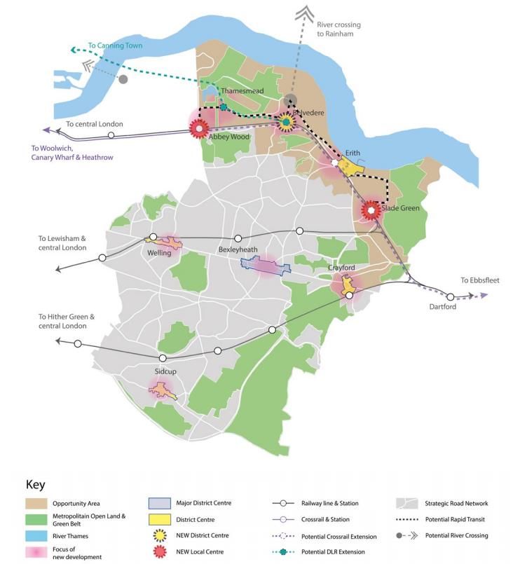
This document has been prepared and checked in accordance with the Lambert Smith Hampton Quality Assurance
procedures and authorised for release. If not signed off by a Director in the Planning, Development and Regeneration
(PDR) division at LSH then this document should be treated as a draft, and as being Private and Confidential. It should
not be for wider distribution without the sign-off and permission of Lambert Smith Hampton.

Signed:

…………………………………………………………………………………………………….

For and on behalf of Lambert Smith Hampton
VOLUME 1: CONTENTS

   SECTION:                                         PAGE:
      1       INTRODUCTION & SCOPE OF STUDY           1

      2       PLANNING POLICY CONTEXT                 4

      3       RETAIL & TOWN CENTRE TRENDS            18

      4       HEALTHCHECKS & COMPETITION PROFILE     29

      5       CATCHMENT & MARKET SHARE ANALYSIS      39

      6       RETAIL CAPACITY ASSESSMENT             44

      7       COMMERCIAL LEISURE NEEDS ASSESSMENT    57

      8       KEY FINDINGS & RECOMMENDATIONS         78
VOLUME 2:   TOWN CENTRE HEALTH CHECKS

VOLUME 3:   IN-CENTRE SURVEY – METHODOLOGY & RESULTS

VOLUME 4:   HOUSEHOLD SURVEY – METHODOLOGY & RESULTS

VOLUME 5:   APPENDICES

       A1: DEFINED CATCHMENT AREA & ZONES

       A2: MARKET SHARE ANALYSIS (%) – CONVENIENCE GOODS (incl SFT)

       A3: MARKET SHARE ANALYSIS (%) – COMPARISON GOODS (incl SFT)

       A4: POPULATION PROJECTIONS & EXPENDITURE GROWTH

       A5: CONVENIENCE GOODS TURNOVER FORECASTS

       A6: COMPARISON GOODS TURNOVER FORECASTS

       A7: RETAIL COMMITMENTS

       A8: RETAIL CAPACITY FORECASTS – GLA PROJECTIONS

       A9: RETAIL CAPACITY FORECASTS – BGS PROJECTIONS

      A10: HOUSING GROWTH AREAS – RETAIL CAPACITY FORECASTS

      A11: LEISURE NEEDS ASSESSMENT – EXPENDITURE GROWTH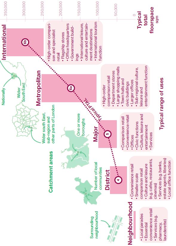
INTRODUCTION & SCOPE OF STUDY
    The London Borough of Bexley (hereafter referred to as the Council) commenced a review of their Local Plan
    in 2017. They began commissioning evidence in 2018, including the update of the Retail and Leisure
    Capacity Study. The 2018 Local Development Scheme (LDS) timetable proposed adopting the new Local
    Plan in 2021, with the plan period ending in 2036. Since then however, circumstances beyond the Council’s
    control - including the Government’s planning reform, the delayed progression of the New London Plan and
    the impact of the COVID-19 pandemic - meant that this timetable was amended to ensure that these changes
    could be properly considered and addressed in the emerging new Local Plan. The new adoption date is now
    scheduled for 2022/23, with the plan period covering 2021 to 2038.

    Lambert Smith Hampton (‘LSH’) was subsequently commissioned by the Council in April 2021 to review,
    refresh and update (in part) the first draft of the Bexley Retail Capacity and Leisure Study (BRCLS)1. This
    study provides the robust evidence needed by the Council to inform the preparation of its new Local Plan
    and other development plan documents pertaining to retail, leisure and other town centre uses. It has been
    prepared in the context of current and emerging local, regional and national development plan policy
    guidance, as well as other key material considerations; principally the National Planning Policy Framework
    (NPPF). Where relevant the study also draws on advice set out in the National Planning Practice Guidance
    (PPG). Both the NPPF an PPG place significant weight on the development of positive plan-led visions and
    strategies to help ensure the vitality and viability of town centres2.

    The study is presented in a series of inter-related Volumes.

    • Volume 2 sets out the key findings of the 2018 centre health check assessments3 for Bexleyheath,
      Crayford, Erith, Welling and Sidcup4.

    • Volume 3 presents the results and tabulations of the 300 street interviews conducted in Bexleyheath,
      Erith, Crayford and Tower Retail Park by NEMS Market Research (NEMS) in 20185.

    • Volume 4 sets out the methodology and key findings of the 1,000 household telephone interviews
      conducted by NEMS across the defined Catchment Area (sub-divided into eight survey zones) in 20186.
    • Volume 5: comprises the other supporting appendices, including the economic capacity tables.

    This Volume 1 study draws on the evidence and research in Volumes 2-5. It provides robust policy
    recommendations to help the Council prepare positive strategies, plans and policies for the growth,

1
    Carter Jonas prepared the initial draft of the BRCLS update in 2018. This was not published for the reasons set out in paragraph 1.1.
2
 Town centres or centres are defined by the NPPF (Annex 2) as city centres, town centres, district centres and local centres but exclude
small parades of shops of purely neighbourhood significance. Unless they are identified as centres in the development plan, existing out-
of-centre developments, comprising or including main town centre uses, do not constitute town centres.
3
 It should be noted that the Council did not commission LSH to update the health checks as part of the April 2021 commission, as it was
determined that more time was needed before the full impacts of the pandemic on each centre could be robustly assessed. The health
checks will therefore be updated by the Council in late 2021, or early 2022.
4
  It should be noted that this study does not review the relative role and function of the Borough’s smaller Neighbourhood Centres. This
assessment has been carried out separately by the local planning authority, and the findings are set out in the Council’s evidence-based
‘Retail Technical Paper’.
5
 Some 150 face-to-face interviews were conducted between 8th and 16th June 2018 in Bexleyheath, 75 in Erith, 40 in Crayford and 35 in
Tower Retail Park, Crayford.
6
    The household survey was conducted between 26th April and 23rd May 2018.

                                                                                                                                            1
management and adaptation of the Borough’s main town centres over the short, medium and long term to
help ensure their future vitality and viability.
Aligned with the NPPF (paragraph 85), London Plan, PPG, and other material considerations, this study
specifically provides advice and recommendations on:
• The quantitative and qualitative need (‘capacity’) for new retail floorspace and leisure uses, “looking at
least ten years ahead” (NPPF, paragraph 85d).
• The scale, type and optimum location to meet this need (where a need is identified) in accordance with
the town centres “first” (sequential) approach.
• The definition of a robust network and hierarchy of town centres.
• The definition and extent of town centre boundaries and Primary Shopping Areas (PSAs).
• The setting of a local impact threshold (the default threshold is 2,50 sqm gross) to help inform the
assessment and determination of applications for retail and leisure developments located outside town
centres and not in accordance with an up-to-date development plan (NPPF, paragraph 89).
It is also important to state at the outset that medium to long term forecasts should be treated with caution.
They are influenced by the dynamic changes in economic, demographic, lifestyle and market trends;
including the rise of online shopping over the last decade, and the recent impacts of the COVID-19 pandemic.
Further to the advice in the NPPF (paragraph 85d), the PPG also recognises the uncertainty in forecasting
long-term retail trends and consumer behaviour, and states that assessments “….may need to focus on a
limited period (such as the next five years)”, but will also need to take the lifetime of the plan into account
and be regularly reviewed7. We therefore advise that the local planning authority should place greater weight
on forecasts over the next five to ten-year period, up to 2031.
For ease of reference this Volume 1 Study is divided into the following inter-related sections:
• Section 2 reviews the national, regional and local planning policy context.
• Section 3 highlights some of the key trends that are driving the dynamic changes in the retail and
leisure sectors at the national and London-wide level, and how this has shaped (and is likely to shape)
the UK’s and the Borough’s urban and retail landscape over the short, medium and long term.
• Section 4 sets out the headline SWOT assessments for the Borough centres (derived from the detailed
2018 health check assessments - see Volume 2), along with the findings of the in-centre surveys
conducted in Bexleyheath, Crayford and Erith (see Volume 3).
• Section 5 summarises the survey-derived market share analysis of shopping patterns for different types
of comparison and convenience goods purchases across the defined Catchment Area (see Volume 4).
• Section 6 sets out the key assumptions and findings of the Borough-wide retail capacity assessment for
new convenience and comparison goods retailing up to 2031 and 2038, based on LSH’s in-house
CREATe economic model. It also assesses the potential capacity for new retail floorspace in the
Borough’s main “Housing Growth Areas” (HGAs), principally to the north of the Borough in the
Opportunity Areas comprising Lower Belvedere and Abbey Wood/Wilton Road.
• Section 7 sets out the findings of the commercial leisure need and ‘gap’ assessment, drawing on the
evidence and market research.
7
PPG. Paragraph 004. Reference ID: 2b-004020190722
2• Section 8 draws on the previous sections and provides recommendations to help inform the Council’s
preparation of robust policies and strategies aimed at maintaining and enhancing the vitality and viability
of the Borough’s retail and leisure offer, and the competitive positions of its main centres, over the ten-
year period to 2031, and over the lifetime of the plan.
3PLANNING POLICY CONTEXT
To help inform the preparation of this study, this section provides a summary of the key national, regional
and local planning policies pertaining to retail, leisure and other main town centre uses.
NATIONAL PLANNING POLICY & GUIDANCE
National Planning Policy Framework (NPPF)
The latest update of the NPPF sets out the Government’s planning policies for England. Planning law
requires that applications for planning permission be determined in accordance with the development plan 8,
unless material considerations indicate otherwise9. The NPPF must therefore be considered in plan-making
and is a material consideration in planning decisions.
The NPPF states that the purpose of the planning system is to contribute to the achievement of sustainable
development, which is defined as meeting the needs of the present without compromising the ability of future
generations to meet their own needs10. The Framework (paragraph 11) sets out the Government’s view of
what the presumption in favour of sustainable development means in practice. For plan-making: “…plans
should positively seek opportunities to meet the development needs of their area, and be sufficiently flexible
to adapt to rapid change” (paragraph 11a).
Chapter 3 (‘Plan-Making’) of the Framework provides guidance to local authorities on preparing local plans.
Paragraph 20 states that policies should set out an overall strategy for the location, scale and quality of
development, and make sufficient provision for new sustainable development. It requires that strategic
policies should look ahead over a minimum 15 year period from adoption, except in relation to town centre
development (see below). In preparing development plans, “policies should be underpinned by relevant
and up-to-date evidence” (paragraph 31). To ensure the local plans and spatial strategies are relevant they
should be reviewed at least once every five years and updated as necessary (paragraph 33).
Chapter 7 (‘Ensuring the vitality of town centres’) provides guidance on plan-making and decision-taking
for retail and other town centre uses. Paragraph 85 states that “planning policies and decisions should
support the role that town centres play at the heart of local communities”, and sets out criteria that local
authorities should consider when preparing planning policies. These include: (a) defining a network and
hierarchy of centres; (b) defining the extent of town centres and Primary Shopping Areas (PSAs); (c) retaining
and enhancing existing markets; and (d) allocating a range of suitable sites in town centres to meet the sales
and type of development likely to be needed, “looking at least ten years ahead”.
Paragraphs 86-90 specifically set out the requirement to apply the sequential and impact tests to determine
applications for new retail, leisure and main town centres that are neither in an existing centre, nor in
accordance with an up-to-date development plan.
8
This includes local and neighbourhood plans that have been brought into force and any spatial development strategies produced by
combined authorities or elected Mayors.
9
Section 38(6) of the Planning and Compulsory Purchase Act 2004 and section 70(2) of the Town and Country Planning Act 1990.
10
Resolution 42/187 of the United Nations General Assembly
4Other Chapters in the NPPF are also relevant to the preparation of this study, and to the Council’s plan-
making and decision-taking policies for its network and hierarchy of centres. For example, Chapter 8
(‘Promoting healthy and safe communities’) sets out the need to achieve healthy, inclusive and safe
places; including the need to plan positively for the provision and use of shared spaces, community facilities
(such as local shops) and other local services to enhance the sustainability of communities and residential
environments (paragraph 92a).
Planning Practice Guidance (PPG)
The latest update of the Planning Practice Guidance (PPG) was issued in September 2020. It provides
specific guidance on plan-making and decision taking for retail, leisure and town centre uses, including
guidance on Permitted Development Rights (PDR) and the new Use Classes Order (‘UCO’) that came into
effect on 1st September 202011 (see below). The Guidance supports the policies and provisions of the NPPF;
placing significant weight on the development of positive plan-led visions and strategies for town centres.
In terms of planning for town centres, the PPG states that a wide range of complementary uses can, if suitably
located, help to support the vitality and viability of town centres. These include residential, employment,
office, commercial, leisure/entertainment, healthcare and educational development. Evening and night-time
activities also have the potential to increase economic activity within town centres and provide additional
employment opportunities.
The PPG (paragraph 004) sets out the importance of evidence-based strategies and visions for town centres
to help establish their role and function over the plan period, the need for new retail, leisure and town centre
uses, and other interventions. However, given the uncertainty in forecasting long-term retail trends and
consumer behaviour, the PPG states that forecasts “…may need to focus on a limited period (such as
the next five years) but will also need to take the lifetime of the plan into account and be regularly
reviewed”12. In those cases where development cannot be accommodated in town centres, the PPG
requires planning authorities to plan positively to identify the most appropriate alternative strategy for meeting
the identified need, having regard to the sequential and impact tests 13. The PPG also sets out several Key
Performance Indicators (KPIs) that “may be relevant in assessing the health of town centres, and planning
for their future”14.
Reform of Use Classes Order & Permitted Development Rights
The Government has issued a series of reforms to the planning system at the time of preparing this study.
The reforms principally relate to Permitted Development Rights (PDR) and the Use Classes Order (UCO)15,
11
Paragraph: 007 Reference ID: 2b-007-20190722. Also refer to: Town and Country Planning (General Permitted Development) (England)
Order 2015, as amended.
12
Paragraph: 004 Reference ID: 2b-004-20190722
13
Refer to Paragraph: 005 Reference ID: 2b-005-20190722. Paragraph 010A ID: 2b-010-20190722 also provides a checklist for local
planning authorities to consider when applying the sequential test.
14
Paragraph: 006 Reference ID: 2b-006-20190722
15
The Town and Country Planning (Use Classes) (Amendment) (England) Regulations 2020/757 was laid before Parliament on 21 st July
2020 and amended the Town and Country Planning (Use Classes) Order 1987.
5alongside the Government’s White Paper “Planning for the Future” (published in August 2020) and the 2021
Planning Reform Bill.
The new UCO came into effect from 1st September 2020 and is relevant to the preparation of this study and
the Council’s plan-making and decision-taking on new retail, leisure and town centre uses. The new UCO
amended and revoked a number of use classes under the 1987 Order, and has replaced them with much
broader use classes. In summary, the main reforms introduced by the new UCO include:
• a new Class E (commercial, business and service uses): which subsumes the former Use Classes
A1 (shops), A2 (financial and professional services) and A3 (restaurants and cafés). It also
incorporates: the former Class B1 (commercial, business and service uses), comprising office, research
and development and light industry; Class D1(non-residential institutions) in part, comprising medical or
health services, clinics, creches, day nurseries and day centres; and Class D2 (assembly and leisure) in
part, comprising gyms or areas for indoor recreation.
• a new Class F1 (learning and non-residential institutions): which includes some of the former uses
under Class D1 (non-residential institutions), including museums, public libraries, art galleries, schools,
and places of worship.
• a new Class F2 (local community uses): which comprises (former Class A1) shops defined as being
“…not more than 280 sqm mostly selling essential goods, including food, and at least 1km from another
similar shop”. This Use Class also includes former Class D2 (assembly and leisure), such as meeting
places/halls, indoor/outdoor swimming baths, skating rinks, and outdoor sport and recreation.
• an extension to the Sui Generis uses (which fall outside the specified use classes) to include the former
Use Classes A4 (pubs and drinking establishments) and A5 (hot food takeaways). It also incorporates
some uses previously classified under D2 (assembly and leisure), including cinemas, concert halls, live
music venues, bingo and dance halls.
The Government also consulted on a variety of changes to PDR in December 2020, including the Class E to
Class C3 (residential) PDR. This PDR replaces the two existing commercial to residential PDRs under Class
O (office to residential) and Class M (conversion of shops, financial services, betting offices and pay day loan
or mixed uses to residential). The Order16 introducing the new PDR under new Class MA will be introduced
on 1st August 2021, and will be subject to prior approval applications. It does contain some conditions and
limitations informed by the consultation responses. For example, it only applies to buildings that have been
vacant for a least three continuous months, to help protect existing businesses. It does not apply to buildings
with a cumulative floorspace of more than 1,500 sqm or to listed buildings, but will apply in Conservation
Areas.
In launching the reforms the Government announced that the regulations will give “…greater freedom for
buildings and land in our town centres to change use without planning permission and create new homes
from the regeneration of vacant and redundant buildings”17. These changes are relevant to this study. It
should be noted that reference is still made throughout the study to classifications defined by the previous
1987 UCO.
16
Town and Country Planning (General Permitted Development etc.) (England) (Amendment) Order 2021
17
https://www.gov.uk/government/news/pm-build-build-build
6REGIONAL PLANNING CONTEXT – THE LONDON PLAN
The London Plan (March 2021)18 is the Spatial Development Strategy for London. It sets out an integrated
strategic economic, environmental, transport and social framework for development up to 2041, and
guidance for each of the London Boroughs’ Development Plans (including Bexley Borough) to ensure that
they are working towards a shared vision. Chapter One sets out the Mayor’s vision for “Good Growth”,
which is defined as “growth that is socially and economically inclusive and environmentally sustainable”. The
London Plan Key Diagram presents the spatial vision, covering London’s growth corridors, Opportunity
Areas, town centres, Green Belt and Metropolitan Open Land. Chapter Two sets out the overall spatial
development pattern for London, focusing on the growth strategies for specific places in London and how
they connect with the wider South East region. Chapters 3-12 provide the topic-specific policies that are
required to deliver the “Good Growth” objectives.
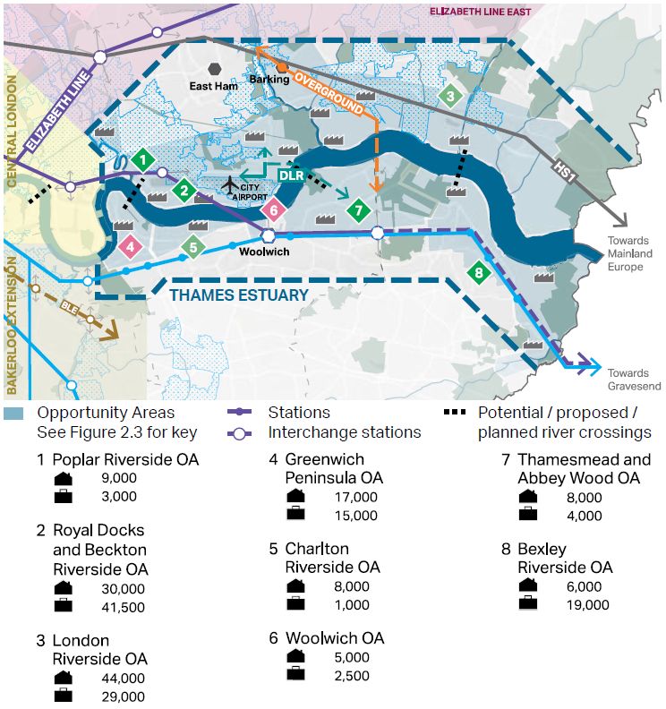
Opportunity Areas and Growth Corridors
The London Plan “Opportunity Areas” (OAs) (Policy SD1) are identified as having the greatest potential to
accommodate substantial new housing, commercial development and infrastructure (of all types), linked to
existing or potential improvements in public transport connectivity and capacity. Each OA (listed in Table 2.1
of the plan) typically has capacity for at least 5,000 net additional jobs or 2,500 net additional homes, or a
combination of the two. The OAs are clustered into “Growth Corridors” (Policy SD2) where investment in
infrastructure and transport will be key to delivery (see Figures 2.4-2.12 of the plan). The Thames Estuary
Corridor (North and South) is identified as one of the largest clusters of OAs in London, with the potential to
deliver over 250,000 new homes and 200,000 new jobs (see figure below reproduced from London Plan). It
is advised that Opportunity Area Planning Frameworks (OAPFs) should be prepared as the first stage in a
plan-led approach, providing clear strategies for the delivery of new development, underpinned by
collaboration with local communities and stakeholders.
A number of transport and infrastructure schemes are being prioritised and assessed to help unlock and/or
connect growth areas19 across the Thames Corridor. The Bexley Riverside OA includes the areas of
Belvedere, Erith, Slade Green and Crayford. The London Plan states that future improvements to
accessibility through better services on the existing transport network, and the extension of the Elizabeth
Line, “…offer the opportunity for significant redevelopment around the stations” (paragraph 2.1.55). In
advance of the potential extension of the Elizabeth line, the London Plan states that the Planning Framework
should explore the level of growth that could be supported through significantly enhanced bus services and
priority measures. Belvedere is recognised as “having potential as a future District centre” (paragraph
2.1.56).
18
The general objectives for the London Plan, and the process for drawing it up, altering it and replacing it, are set out in the Greater
London Authority Act 1999 (as amended) and the Town and Country Planning (London Spatial Development Strategy) Regulations 2000.
19
This include the Silvertown Tunnel; a new river crossing linking Rotherhithe and Canary Wharf; an extension of the DLR across the
river from Gallions Reach to Thamesmead and beyond; and Barking Riverside to Abbey Wood London Overground crossing.
7Figure 2.1: Thames Estuary Growth Corridor and Opportunity Areas
Source: London Plan (2021). Figure 2.7
Town Centres & High Streets
London’s Central Activities Zone (CAZ) and Town Centres are the primary locations for commercial activity
in the capital, and have a crucial role to play in supporting London’s growth. The London Plan sets out how
this growth should be managed and planned for.
Policy SD6 (Towns Centres and High Streets)20 specifically supports the vitality and viability of London’s
varied town centres. The need for “adaption and diversification” is recognised. Many town centres and the
surrounding areas have potential to accommodate significant quantities of new housing, making the most of
walking, cycling and public transport connectivity. The London Plan recognises that residential-only schemes
in town centres may be appropriate outside the PSA, where it can be demonstrated that they would “not
undermine local character and the diverse range of uses required to make a town centre vibrant and viable”
(paragraph 2.6.7). The London Plan states that town centres will need to “diversify the range of commercial
uses, particularly smaller centres and those with projected decline in demand for retail floorspace” (paragraph
2.6.4). Boroughs and others should therefore ensure their strategies, policies and decisions encourage a
broad mix of uses, while protecting core retail uses to meet demand.
The London Plan takes a strong “town centres first” approach. Policy SD7 (see Parts A1-A3)21 discourages
out-of-centre development through the application of the sequential and impact tests. Boroughs are also
20
Policy SD6 does not apply to CAZ Retail Clusters or any town centres located wholly within the Central Activities Zone (CAZ).
21
With limited exceptions for existing viable office locations in outer London (see Policy E1 Offices).
8required to assess the redevelopment potential of existing out-of-centre retail and leisure parks for housing
intensification, and ensure such locations become more sustainable in transport terms, by securing
improvements to public transport, cycling and walking22.
For plan-making, Policy SD7 (Parts B1-B4 and C1-C7)23 states that each London Borough should proactively
plan to meet forecast need for main town centre uses by allocating sites within or (where justified) on the
edge of town centres, and through town centre boundary reviews. Where town and edge of centre sites are
not available, local plans should identify future potential town centres that could accommodate the forecast
additional need, and set appropriate policies, boundaries and site allocations for these areas24. This will
deliver a sustainable pattern of development by focusing main town centre uses in existing centres, or
through the creation of new centres (paragraph 2.7.2).
Town Centre Network
Policy SD8 sets out London’s Town Centre Network (also see Figure 2.17 and Annex 1 of the London
Plan). In summary, the network comprises:
• “International”, “Metropolitan” and “Major” Town Centres – are the focus for the majority of higher
order comparison goods retailing, with the potential for higher density employment, leisure and
residential development in a high quality environment. Table A1.1 (Annex 1) to the London Plan
classified Bexleyheath as a “Major Centre”.
• “District Centres” - provide mainly convenience goods and services, and social infrastructure for more
local communities and are accessible by public transport, walking and cycling. They also provide
opportunities for higher density mixed-use residential development and improvements to their
environment. Crayford, Erith, Sidcup and Welling are defined as “District Centres” by the London Plan
• “Local” and “Neighbourhood” Centres - typically serve a localised (walking and cycling) catchment
and include local parades and small clusters of shops, mostly for convenience goods and other
services. Together with District Centres they can play a key role in addressing areas deficient in local
retail and other services.
The figure below summarises the typical scale and types of uses provided under the different classifications.
The London Plan recognises that the town centre network is dynamic, and the role and function of centres
will change over time. Within OAs, for example, it may be appropriate to designate new town centres to meet
the needs of the local community and to serve areas of deficiency for certain uses. It may also be appropriate
to re-classify some existing centres, in order to respond to shifts in demand for commercial uses or to reflect
significant spatial, environmental and public transport connectivity improvements to existing out-of-centre
retail parks.
22
Redevelopment of retail and leisure parks to deliver housing intensification is encouraged by London Plan Policy H1 (Increasing housing
supply). This should not result in a net increase in retail or leisure floorspace in an out-of-centre location unless the proposal is in
accordance with the Development Plan or can be justified through the sequential and impact tests in Parts A(1) and A(2).
23
Policy SD7 does not apply to CAZ Retail Clusters or any town centres located wholly within the Central Activities Zone.
24
Having regard to Policy SD8 Town centre network and the future potential town centre classifications in Annex 1 of the London Plan.
9Figure 2.2: The London Plan - Town Centre Classifications
Source: London Plan (March 2021). Figure 2.18.
Given the strategic importance of the larger town centres, “…changes to the classification of existing or
proposed International, Metropolitan and Major centres must only be undertaken through the London Plan”
(paragraph 2.8.3). Changes to the classification of District, Local and Neighbourhood centres can be brought
forward in Local Plans, but will need to be supported by “…robust evidence, particularly looking at the wider
impact on the network, informed by regular town centre health checks, and undertaken alongside reviews of
town centre boundaries”.
Table A1.1 (Annex 1) to the London Plan provides an indication of potential future changes to the town centre
network over the Plan period, including new potential centres. Belvedere is identified as a potential new
“District Centre”. The London Plan states that centres with a future potential network classification (as
identified by Table A1.1) are “…not recommended for immediate reclassification, however it is recognised
that they may be appropriate for future reclassification, subject to strategic and Local Plan policies and
conditional on matters such as capacity analysis, impact assessments, land use, public transport, walking
and cycling, planning approvals and full implementation” (paragraph 2.8.4).
Against this background, this study provides robust evidence to support the future reclassification of
Belvedere (hereafter referred to as ‘Lower Belvedere’ to help differentiate from the Belvedere – Nuxley Road
centre) to a ‘District Centre’ in the Borough’s network and hierarchy of centres.
Town Centre Strategies & Uses
Policy SD9 encourages the preparation of Town Centre Strategies (Part A). This particularly applies to
centres that are undergoing transformative change (including decline), and/or where significant infrastructure
is planned, and/or where new potential centres are identified (by Table A1.1). Policy SD9 (Parts B-D) states
that Boroughs should: (i) carry out regular town centre healthchecks; (ii) introduce targeted Article 4
10Directions where appropriate and justified to remove PDR (including office/retail to residential) to sustain
town centre vitality and viability 25; and (iii) take a proactive approach to redevelopment opportunities.
The London Plan recognises and supports the importance of a diverse and competitive retail sector, but also
acknowledges that retailing is undergoing restructuring in response to recent trends and future forecasts,
including the growth of online sales.
Aligned with the objectives of Policies SD6-SD9, Policy E9 (Retail, markets and hot food takeaways) states
that in preparing or reviewing Development Plans, Boroughs should: (i) identify future requirements and
locations for new retail development; (ii) identify areas for consolidation of retail space where this is surplus
to requirements; and (iii) set out policies and site allocations to secure an appropriate mix of shops and other
commercial uses, informed by local evidence and town centre strategies.
Part C sets out further requirements for Development Plans and proposals, including: (i) provision of
convenience retail (particularly in smaller District, Local and Neighbourhood Centres), to secure inclusive
neighbourhoods and a sustainable pattern of provision (Part C2); (ii) support for all London’s markets, to help
enhance their offer and contribute to local identity and the vitality of town centres (Part C5); and the
management of existing edge-of-centre and out-of-centre retail (and leisure) by encouraging comprehensive
redevelopment for a diverse mix of uses in line with Policies SD6-SD9 (Part C6).
Parts D and E state that where development proposals contain hot food takeaway uses, these should not be
permitted within at least 400 metres of entrances/exits to schools, and where hot food takeaway uses are
permitted, Finally Part F states that development proposals involving the redevelopment of surplus retail
space should support other planning objectives and include alternative town centre uses on the ground floor
where viable (in accordance with Policy SD7).
The London Plan (paragraph 6.9.9) recognises the positive impact that small and medium-sized enterprises
(SMEs) can have on the diversity, vitality and viability of centres. However, in parts of London, small shops
suitable for occupation by SMEs may be in short supply and affordability can be a key concern. Larger
developments that include a significant amount of commercial floorspace can contribute to the diversity,
vitality and vibrancy of town centres by providing a range of unit sizes that includes smaller premises. The
High Streets for All report26 found that almost 70% of small businesses consider rent unaffordable with
average retail rents increasing 4% per annum over the period 2009 to 201627. Where there is local evidence
of need, Development Plans should require affordable commercial and shop units (secured through planning
conditions or planning obligations as appropriate).
LOCAL PLAN CONTEXT
The Borough Council is currently in the process of reviewing and updating its Local Plan, and this evidence-
based study will help to inform its preparation28. In advance of its adoption the Bexley Core Strategy (adopted
25
When considering office to residential Article 4 Directions in town centres, Boroughs are encouraged to consider guidelines in Annex 1
and Policy E1 Offices of the London Plan, as well as local circumstances
26
High Streets for All, GLA, 2017
27
London Town Centre Health Check, GLA, 2017
28
All information on the Local Plan Review, including its content and timetable can be found on the Council’s website:
https://www.bexley.gov.uk/services/planning-and-building-control/planning-policy/local-plan-review
11February 2012) and ‘saved’ policies (2007) in the Unitary Development Plan (UDP) (adopted April 2004) are
the key Development Plan Documents (DPDs). The main provisions and policies relevant to this study are
briefly summarised below.
Unitary Development Plan (2004)
The Unitary Development Plan (UDP) was adopted in 2004. Following the publication of the Core Strategy
in 2012 (see below), the most relevant ‘saved’ policies for new retail and town centre uses in the UDP are:
(i) Policy SHO2, which promotes town centres as the focus for new retail development; (ii) Policy SHO4,
which relates to the development of non-retail uses within core shopping frontages; and (iii) Policies SHO5-
SH06, which cover non-retail development proposals in non-core shopping frontages. The UDP defined the
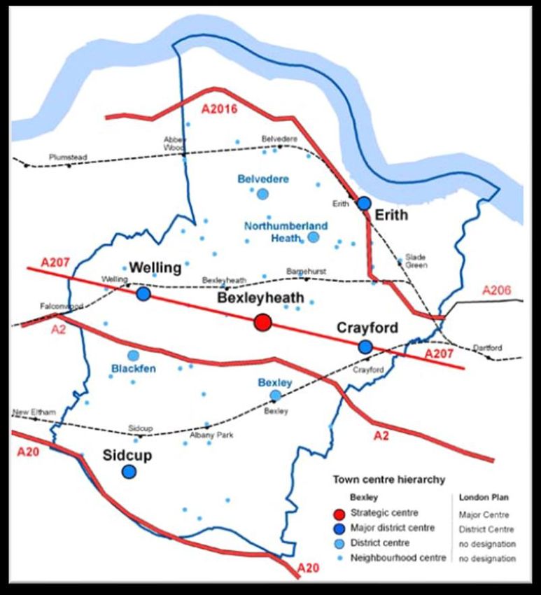
following ‘four tier’ functional hierarchy:
▪ Strategic Centre: Bexleyheath;
▪ Major District Centres: Crayford, Erith, Sidcup and Welling;
▪ District Centres: Belvedere (Nuxley Rd), Bexley, Blackfen and Northumberland Heath; and
▪ Neighbourhood Centres: comprising 52 smaller centres.
All other strategic retail and town centre related policies have been replaced by policies contained in the Core
Strategy (see below).
Core Strategy (2012)
The Core Strategy sets out the spatial planning framework for the Borough until 2026. It is split into four
chapters (and four appendices).
Chapter 2 sets out the Council’s Vision and Spatial Objectives. The key spatial objective is: “To promote
development that assists regeneration and renewal within the borough and enhances the quality of life of all
Bexley residents, and encourage development that promotes social inclusion, addresses local social and
economic needs and provides a better environment”. This is illustrated by the Vision Diagram 29.
Chapter 3 (Achieving Sustainable Development) sets out the spatial strategy for the amount and location
of future growth in the Borough (Policy CS01). Sustainable development will be encouraged by focusing
new housing and employment development in parts of the Thames Gateway, particularly the London Plan
Opportunity Areas, as well as locations in and around the borough’s main town centres. The strategy is
illustrated by a Key Diagram that identifies the Borough’s main opportunities, designations and constraints.
The Borough is then divided into six geographic regions based on ward boundaries focussed on the main
town centre in each region30. Each region has its own section and vision, and a policy that is mainly focused
on the region’s sustainable growth areas, which enable the region to contribute towards sustainable
29
See Map 2.1 (page 13) of the Core Strategy
30
See Bexley Core Strategy (2012). Map 3.1, page 15.
12development. The following policies for each region set out the requirements for new development, and
current approaches being taken that justify the proposed policy.
• Bexleyheath Region (Policy CS02 and Map 3.3) - Policy states that the new housing and employment
growth in the region will mainly be focused in and around the town centre.
• Belvedere Geographic Region (Policy CS03 and Map 3.4) – comprises the Belvedere, Thamesmead
East and Lesnes Abbey wards. It is located within the Thames Gateway and includes two London Plan
Opportunity Areas. Belvedere provides the main shops, supporting services, facilities and local
employment opportunities in the region, supported by a network of smaller neighbourhood centres.
There is no major town centre that serves this region.
• Erith Geographic Region (Policy CS04 and Map 3.5) – is located within Thames Gateway and partly
within the Bexley Riverside Opportunity Area, and is identified as having significant growth potential.
Policy supports new commercial, housing and employment growth in and around Erith Town Centre and
Slade Green; and the safeguarding of land to enable the future extension of Crossrail from Abbey Wood
to Gravesend and Hoo Junction.
• Crayford and Old Bexley Geographic Region (Policy CS05 and Map 3.6) – located on the eastern
edge of the Borough the main centres are Crayford and Bexley (otherwise known as Bexley Village or
Old Bexley). Policy seeks to support Crayford’s business function and focus new housing and
employment growth in and around the town centre and, to a lesser extent, Old Bexley.
• Sidcup Geographic Region (Policy CS06 and Map 3.7) – seeks to support Sidcup’s key role as the
most significant centre in the south of the Borough, which functions as Bexley’s southern gateway.
Housing and employment growth will primarily be focused in and around Sidcup town centre, Sidcup
Station and Foots Cray employment area.
• Welling Geographic Region (Policy CS07 and Map 3.8) - Welling town centre is situated in the heart
of this region and is the most significant shopping area in the west of the Borough. Policy seeks to
focus housing and employment growth in and around the town centre.
Chapter 4 (Managing the Built Environment) sets out the policy responses to common issues that affect
large parts or all of the Borough. The plan below shows the Borough’s well established network of town
centres as set out in the UDP. With Bexleyheath as the Strategic Centre, along with four Major District
Centres and four District Centre. The Core Strategy states that these centres are: “..at the heart of their
communities, provide a wide range of goods and services and are generally the most accessible locations in
the borough” (paragraph 4.6.1).
Policy CS14 (Town Centre Vitality and Viability) sets out the Borough-wide town centre policies and states
that the Council will maintain and enhance the vitality and viability of its existing centres 31 through a range of
measures, including: applying the sequential and impact tests; designating Primary Shopping Areas (PSAs);
promoting a diverse mix of town centre uses; creating strategies for town centres in future policy documents;
and securing public realm enhancements.
31
See Map 4.4 (page 78) of Bexley Core Strategy showing the town centre locations and hierarchy.
13Figure 2.3: Town centre locations and hierarchy in Bexley Borough
Source: Bexley Core Strategy (February 2012). Map 4.4, page 78.
The 2008 Bexley Retail Capacity Study (BRCS 2008) confirmed that the existing town centre hierarchy was
performing well and forecast the need for up to 5,294 sqm net of new convenience goods floorspace and
29,279 sqm of comparison space by 202732. The majority (80%) of this new retail floorspace was forecast
for Bexleyheath. There was more limited capacity for Sidcup (9%) and Erith (11%), and no capacity in Welling
and Crayford. An analysis of neighbourhood centres also confirmed no significant gaps in provision.
Other Development Plans and Material Considerations
Other Supplementary Development Plans (SPDs) and evidence-based documents that provide background
to the preparation of this study include:
• Crayford Strategy and Action Plan (adopted July 2005) - details development proposals and projects
to promote environmental, cultural and economic improvements to the town centre.
• Thamesmead and Abbey Wood SPD (adopted December 2009) - outlines key principles to guide
development in Thamesmead and Abbey Wood providing guidance on a number of opportunity areas.
Specifically, Thamesmead town centre is identified as the retail and civic heart for the community,
supported through a neighbourhood level function with smaller shops and services. Abbey Wood will
become a major transport interchange and a gateway to Thamesmead.
32
The higher capacity forecast is based on higher population growth proposed over the plan period.
14• Bexleyheath Night Vision Strategy (adopted February 2010) - the strategy and action plan (for the
period up to 2015) promotes greater diversity in the town’s shops, bars, pubs and cafés, alongside
public realm improvements, to improve the evening and night time economy.
• Bexleyheath Development and Improvement SPD (adopted February 2010) - provided the
framework and action plan to help guide future town centre interventions and developments. The
development opportunities were grouped into key focus areas (including Albion Road sites,
pedestrianised Broadway and the Civic Quarter.)
• Erith Western Gateway Development Framework (adopted January 2012) – this SPD covers a
collection of sites in the north of the town centre and adjacent to the River Thames totalling some 7.7
hectares under different ownerships. It sets out the Council’s vision to transform Erith’s riverfront.
• Bexley Retail Capacity Study Update (BRCSU 2015) – this study updated the BRCS 2008 and
forecast a higher Borough-wide retail capacity for up to 7,421 sqm net of new convenience floorspace
and 49,068 sqm of comparison floorspace by 2036 (based on the Council’s higher housing growth
scenario). This updated 2021 study will supersede the findings of the BRCSU 2015.
In addition to these documents, the Bexley Growth Strategy (BGS), published in December 2017, sets out
how the Council proposes to manage housing, economic growth and supporting infrastructure in the Borough
up to 2050, working with a range of partners 33. However, it should be noted that the delivery of the BGS is
predicated on significant transport and infrastructure improvements, including the Elizabeth Line (Crossrail)
extension and improvements to north-south linkages within the Borough. With that caveat in mind, the
Growth Strategy has the following growth ambitions in relation to the Borough’s existing town centres, and
proposed new centres.
In brief, the BGS is divided into three inter-related parts. Part I identifies the main opportunities and
challenges facing the Borough, and sets out the vision for a “well-connected Borough”. Major infrastructure
investment represents a key driver of growth34, as part of the Thames Gateway opportunity, with growth
focussed in the London Plan Opportunity Areas covering Thamesmead/Abbey Wood and Bexley
Riverside, as well as the Borough’s main town centres. Subject to the provision of the right levels of
infrastructure, in the right locations, potential is identified for up to 31,500 new homes and 17,500 new jobs.
Growth areas at Belvedere, Erith, Thamesmead, Slade Green and Crayford are identified as having
significant development potential. This is set out in the BGS vision extract and Key Spatial Diagram
(reproduced below).
33
Partners involved in the preparation of the BGS included the Greater London Authority (GLA) and Transport for London (TfL), along
with residents, businesses and other key stakeholders. See the governance structure diagram in the BGS (Figure 1, page 8).
34
The key infrastructure projects include: (i) a public transit corridor, in phases, from North Greenwich to Slade Green; (ii) a docklands
light rail (DLR) extension from Gallions Reach through Thamesmead to Belvedere; (iii) the extension of the Elizabeth Line (Crossrail) east
of Abbey Wood towards Ebbsfleet; and (iv) the road based-river crossings connecting Belvedere with Rainham and Thamesmead with
Gallions Reach.
15Figure 2.4: Key Diagram - Proposed Infrastructure and Development Opportunities
Source: BGS (2019). Figure 6; page 31.
Part II sets out guidance for the development of the various key land uses, with the underlying objective to
promote sustainable development. The Borough’s town centres are identified as the desired locations for
shops, community facilities, new employment opportunities and additional housing. The key elements of the
approach to town centres and retail include: (i) maintaining and strengthening the town centre hierarchy by
encouraging appropriate commercial and housing development, alongside improvements to connectivity and
environmental enhancements; (ii) consolidating town centre boundaries and allowing centres to adapt
through greater flexibility to the mix of uses; and (iii) creating new town centres in major growth areas to
service the future needs of the growing population, whilst complementing the existing hierarchy.
Part III puts forward a strategy for implementation. Thamesmead, Belvedere, Erith, Slade Green and
Crayford are identified as the focus for growth. These Growth Areas are predominantly in the north of the
Borough, focussed on existing/proposed transport hubs, and within the London Plan Opportunity Areas. The
‘Development Frameworks’ for each area are summarised in the table below.
16Table 2.1: Bexley Growth Areas – Summary of Development Frameworks
Thamesmead Belvedere Erith Slade Green Crayford
▪ Up to 4,000 new ▪ Up to 8,000 new ▪ Up to 6,000 new ▪ Up to 8,000 new ▪ Up to 1,000 new
homes and 5,000 homes and 3,500 homes and 2,000 homes and 1,500 homes and 1,000
new jobs. new jobs. new jobs. new jobs. new jobs.
▪ Promote medium to ▪ New centre that ▪ Consolidate the town ▪ Designate Slade ▪ Reconfigure the
high density promotes Belvedere centre and realise Green as a Local town centre by
residential and as a sub-regional the development Centre and consolidating under-
employment shopping potential of industrial reposition new town utilised secondary
development. destination. and residential centre uses around a frontages north of
Considered an estates in the growth new station. the River Cray and
appropriate location ▪ Promote high density area. refocusing retail
for tower retail typology of ▪ Promote the activity towards the
development (up to smaller units around ▪ Promote the extension of station and
15 storeys). the transport extension of Crossrail, which will promoting better
interchange, with Crossrail, which will improve connectivity integration with the
▪ Designation of Wilton large retail units improve connectivity and development rest of the town
Road as a Local (servicing anchor and development potential. centre.
Centre to promote retailers) within a potential.
shopping and shopping quarter in ▪ Promoting new ▪ Promote better
service provision. the new town centre. ▪ Higher density of employment areas to movement within the
residential and the north of the town centre/
▪ Medium density retail ▪ Create a new commercial uses (4 centre that link to the
will service the new transport to 8 storeys), new Local Centre. ▪ Promote more
residential interchange improvement and efficient use of land
development and the incorporating existing expansion of existing ▪ Promote high density through medium
Crossrail station. rail services and shops, businesses development around density typologies for
proposed extension and services, the town centre (4 to residential and retail
▪ Improve the to Crossrail and 8 storeys). development.
employment area at DLR. ▪ Promote a ‘traditional
Veridion Park. high street’ typology.
▪ Release of industrial
land for high density
residential and mixed
use development.
New centres are proposed for the Abbey Wood, Belvedere and Slade Green Housing Growth Areas to meet
the needs of future residents. The potential to support new retail development in these Growth Areas is
assessed as part of the retail capacity assessment in Section 6.
SUMMARY
In summary, the underlying objectives of national, regional and local plan policy is to maintain and enhance
the vitality and viability of town centres, and to promote new sustainable development and economic growth
in town centre locations ‘first’.
This policy objective is even more critical at this point in time as town centres and high streets are facing
increasing economic challenges from competing forms of retailing. These include the long term competition
from out-of-centre shopping and leisure facilities and, over the last decade, the growth in online shopping.
These trends and challenges have been further accelerated by the COVID-19 pandemic, and are covered in
more detail in the next section.
17RETAIL AND TOWN CENTRE TRENDS
This section summarises some of the key economic, consumer and property market trends that have driven
the changes in the retail and leisure sectors over the last decade, and which will continue to shape change
in the future. It also briefly examines whether and how town centres can respond to these dynamic trends
to remain competitive and enhance their overall vitality and viability in the future. It should be noted at the
outset that this section was written at the time of the Coronavirus (‘COVID-19’) pandemic.
ECONOMIC OUTLOOK
In the 18-24 months prior to the pandemic the UK economy had been characterised by low growth; GDP
increased by +0.3% in the third quarter (Q3) of 2019, which was the weakest growth recorded since 2010
(Q1)35. The impact of the pandemic has resulted in the UK economy experiencing the biggest annual decline
in GDP (-9.9%) for over 300 years. The latest ONS figures show the economy narrowly avoided a double-
dip recession in 2020 following positive growth of +1% in the final quarter due to the loosening of the COVID-
19 restrictions in the run-up to Christmas. The country was subsequently placed into a third lockdown from
January 2021.
The impact of the pandemic, to date, has also resulted in Britain’s budget deficit (i.e. the gap between public
spending and income from taxes) reaching the highest levels recorded since World War II. Government
borrowing climbed to a record £240.9 billion in the first eight months of 2020, and the Office for Budget
Responsibility (OBR) forecast that this could be around £400 billion by Summer 2021.
Against this background, Experian Business Strategies (Experian) predict that the economy will not recover
to pre-pandemic levels until at least 2022 36. However, the unprecedented nature of the global pandemic
means that all forecasts are subject to greater than usual uncertainty and volatility.
RETAIL SPENDING
The pandemic has inevitably had a dramatic impact on consumer spending and retail sales in 2020. Although
consumer spending has been a key driver of economic growth since the BREXIT referendum in June 2016,
there had been increasing signs pre pandemic that growth was starting to “soften”. For example, household
spending slowed to an eight year low (+1.2%) in 2019 due principally to the impact of BREXIT on consumer
confidence. The latest figures show that household spending fell by over 20% quarter-on-quarter in the
second quarter of 2020; the largest quarterly contraction on record. Spending on hospitality, travel and leisure
was dramatically impacted during this period. Retail also suffered as businesses were forced to close;
although this was partly cushioned by an increase in food and online purchases.
The latest Experian37 retail and leisure spend per head forecasts show for:
• Convenience goods: a significant +8.4% growth in spend in 2020. This is explained by the increase in
household spend on “essential” food and convenience goods during the pandemic. This followed
35
Sourced from the Office for National Statistics (ONS)
36
Experian Retail Planner Briefing Note 18 (October 2020).
37
Experian Retail Planner Briefing Note 18 (October 2020). Figures 1a and 1b. The average expenditure per capita figures are a key
input to the retail capacity and leisure needs assessments.
18negative growth in 2019 (-0.9%), and for most years since 2005. Experian predict that the boost to
convenience spend in 2020 will start to “unwind” in 2021; assuming a return to more “normal”
conditions. Experian forecast a fall in convenience spend in 2021 (-6.2%), and annual (per capita)
growth over the medium to long term “flatlining” at around +0.1% up to 2038.
• Comparison goods: experienced a year-on-year growth from a low of -1.0% in 2009, to a high of
+5.7% in 2015. Following negative growth of -8.5% in 2020, Experian predict that (per capita) growth
will settle at around +3% per annum on average up to 2038. This growth forecast is significantly below
the historic long term trend (1997-2019) of +5.5% per annum.
• Leisure spend: Following a dramatic -53.8% fall in leisure spend per head in 2020, Experian forecast a
“bounce” back to growth in 2021 (+64.7%) and 2022 (+14.8%). Average yearly growth is then forecast
to settle at approximately +2.5% over the period 2023-27 and +0.9% over the long term (between 2028-
2038). This growth in leisure spend is consistent with the historic average growth of +1.1% per annum
recorded between 2012-18, and higher than long term trend (1997-2019) of -0.6% per annum.
Clearly any further dampening of growth rates over the short to medium term due to the on-going impact of
the pandemic will impact on the economic capacity forecasts identified by the study, as well as on the
business models of investors and operators (including the demand for new space).
THE RISE OF ONLINE SHOPPING
The growth in non-store retail sales has undoubtedly had the most significant impact on consumer spend
and behaviour over the last decade, and on our High Streets and traditional shops 38. ONS figures show that
the value of non-store retail sales (including the internet) stood at £84.2bn in 2019 (in 2016 prices). This
represented a significant growth from £17.1bn in 2006.
As the figure below shows, SFT’s overall market share (as a proportion of total UK retail sales) increased
from 5.5% in 2006 to 25.2% in 2021. In other words online sales accounted for approximately one-quarter
of every pound spent on retail goods in 2021. Of this total non-store retail sales, Experian estimate that
comparison and convenience goods retailing achieved market shares of 29.1% and 18.1% respectively.
The latest Experian forecasts indicate that total SFT market shares will increase to 34.5% by 2038 (i.e. over
one in every three pounds spent on retail in 17 years’ time will be online). Comparison and convenience
goods non-store retail sales are forecast to reach 38% and 24.3% respectively.
Experian predict that the pace of e-commerce growth will slow over the long term as research suggests that
internet use is now almost at capacity. However other research (published before the impact of the
pandemic) has predicted that the growth in online sales could be even higher over the next decade;
accounting for approximately 53% of total retail sales by 202839. This faster growth it is argued will be driven
by the significant improvements in the convenience and choice of online purchasing through further advances
in technology (including mobile/wearable technology and Artificial Intelligence), alongside improved web-
based platforms and social media. The expansion of 5G and fibre networks, cheaper and faster deliveries
38
Non-store retailing is commonly referred to as Special Forms of Trading (SFT). This comprises all non-store retail sales made via the
internet, mail order, stalls and markets, door-to-door and telephone sales. On-line sales by supermarkets, department stores and
catalogue companies are also included in the data collected by the Office for National Statistics (ONS).
39
‘The Digital Tipping Point – 2019 Retail Report’ (Retail Economics and Womble Bond Dickinson)
19You can also read