Rhode Island Ocean Special Area Management Plan - Case Study Summary Report
←
→
Page content transcription
If your browser does not render page correctly, please read the page content below
Rhode Island Ocean Special
     Area Management Plan

                 Case Study Summary Report
            Service Contract: EASME/ECFF/2014/1.3.1.8/SI2.717082

May, 2017

                                Maritime Affairs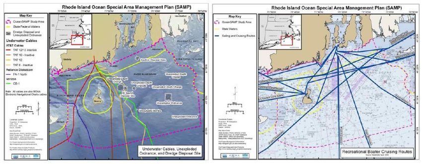
EUROPEAN COMMISSION

Directorate-General for Maritime Affairs and Fisheries
Directorate A — Maritime Policy and Blue Economy
Unit A.2 — Blue Economy Sectors, Aquaculture and Maritime Spatial Planning
Contact: Valentia Mabilia
E-mail: valentina.mabilia@ec.europa.eu
European Commission
B-1049 Brussels

Executive Agency for Small and Medium-sized Enterprises (EASME)

Department A - COSME, H2020 SME and EMFF
Unit A3 EMFF
B-1210 Brussels
http://ec.europa.eu/easme
Contact: David Sanmiguel Esteban
E-mail: EASME-EMFF@ec.europa.eu

Lead authors: Gonçalo Carneiro1, Sara Méndez Roldán2, Jennifer McCann3
Contributing authors: Tiffany Smythe3

1
  NIRAS Indevelop Sweden (www.niras.se)
2
  NIRAS Consulting Ltd (www.nirasconsulting.co.uk)
3
  University of Rhode Island Coastal Resources Centre (URI CRC), www.crc.uri.edu/

Acknowledgements: We thank all interview participants, stakeholders, authorities, communities - your
time and dedication have been invaluable to capture the range of views that this report has attempted to
synthesise, and we thank the US Northeast Ocean Council for their engagement. This report and the Global
MSP Inventory developed for this study use information from the UN Environment MSP in Practice Initiative
and its associated database of MSP processes. We thank UN Environment for its support in sharing this
information.

Nota Bene
This document is part of the “STUDY ON INTERNATIONAL BEST PRACTICES FOR CROSS-BORDER MARITIME
SPATIAL PLANNING ". In order to get a complete understanding of the concepts, definitions and
methodology used in this document it is advised to read the main report first.
EUROPEAN COMMISSION

       Rhode Island Ocean Special
         Area Management Plan

                    Case Study Summary Report
  Reporting on the Service Contract: EASME/EMFF/2014/1.3.1.8/SI2.714082: Study on
          international best practices for cross-border Maritime Spatial Planning

                                  Coordinator: NIRAS

                                    Project Partners:

          UNEP-WCMC, URI CRC, TNC, Xiamen University, SAERI, WMU, QED

                   Directorate-General for Maritime Affairs and Fisheries
                                     MARE/2014/40
2017                                                                        EN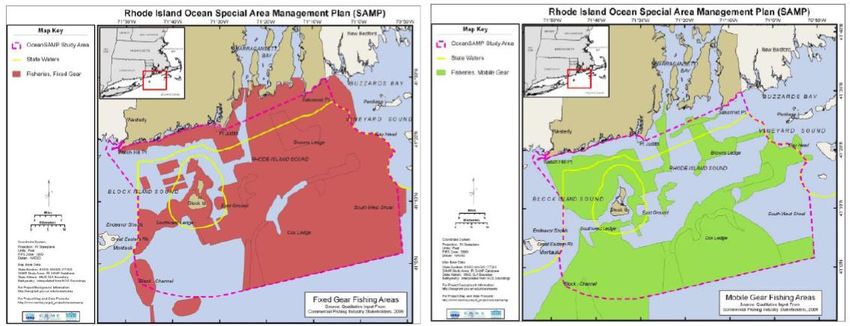
RI Ocean SAMP Case Study Summary Report

          Europe Direct is a service to help you find answers
             to your questions about the European Union.

                            Freephone number (*):

                         00 800 6 7 8 9 10 11
  (*)   The information given is free, as are most calls (though some operators, phone
     boxes or hotels may charge you).

LEGAL NOTICE
This document has been prepared for the European Commission however it reflects the views only of the
authors, and the Commission cannot be held responsible for any use which may be made of the information
contained therein.

More information on the European Union is available on the Internet (http://www.europa.eu).

Luxembourg: Publications Office of the European Union, 2017

ISBN 978-92-9202-253-2
doi: 10.2826/514498

© European Union, 2017

Study on International Best Practices for Cross-border MSP                                    Page | iv
RI Ocean SAMP Case Study Summary Report

TABLE OF CONTENTS
LIST OF ABREVIATIONS AND ACRONYMS ........................................................................ VI

EXECUTIVE SUMMARY ................................................................................................. VII

1.    INTRODUCTION ...................................................................................................12

2.    METHODOLOGY ....................................................................................................13

3.    KEY FINDINGS .....................................................................................................15

      3.1.     Context ......................................................................................................15
               3.1.1.      Natural environment .......................................................................15
               3.1.2.      Socio-economic uses.......................................................................16
               3.1.3.      Governance of coastal and marine areas ...........................................19
               3.1.4.      Cross-jurisdictional collaboration in coastal and marine planning ..........21
      3.2.     Drivers, issues and goals ..............................................................................27
               3.2.1.      Drivers and issues at initiation .........................................................27
               3.2.2.      Goals and principles ........................................................................28
               3.2.3.      Use of the ecosystem-based approach ..............................................29
      3.3.     Overview for the Rhode Island Ocean SAMP ....................................................32
               3.3.1.      Overview of the process ..................................................................32
      3.4.     Funding the Ocean SAMP ..............................................................................33
               3.4.1.      Legal basis ....................................................................................34
               3.4.2.      Intra- and interstate institutional collaboration ...................................34
      3.5.     Scope and design of the Ocean SAMP ............................................................37
               3.5.1.      The institutions of the Ocean SAMP ...................................................37
               3.5.2.      Land-sea interactions in the planning phase.......................................38
      3.6.     Collaboration and consultation in the planning phase .......................................40
               3.6.1.      Consultation with other state and federal agencies, legislators and
                           federally-recognised tribes ..............................................................41
      3.7.     Features of the implementation phase ...........................................................44
               3.7.1.      Adaptive management of the Ocean SAMP .........................................46

4.    OUTCOMES AND LESSONS LEARNED ......................................................................54

      4.1.     Achievement of planned goals and impacts of the Ocean SAMP .........................54
               4.1.1.      Impacts on socio-economic conditions, including sea use conflicts ........54
               4.1.2.      Impacts on ecosystem goods and services, and on biodiversity ............55
               4.1.3.      Impacts on institutional coordination, including across jurisdictional
                           borders .........................................................................................56
      4.2.     Lessons learned ..........................................................................................57
               4.2.1.      Lessons learned from the Ocean SAMP process in general ...................57
               4.2.2.      Lessons learned about cross-jurisdictional collaboration ......................58

REFERENCES ...............................................................................................................60

ANNEX 1 – ANALYTICAL FRAMEWORK (ABRIDGED VERSION) ............................................62

ANNEX 2 – LIST OF PARTICIPANTS AND SCHEDULE .........................................................64

ANNEX 3 – LEGAL AND GOVERNANCE ANALYSIS .............................................................67

Study on International Best Practices for Cross-border MSP                                                           Page | v
RI Ocean SAMP Case Study Summary Report

LIST OF ABREVIATIONS AND ACRONYMS

AMI            Area of Mutual Interest

BOEM           Bureau of Ocean Energy Management

BOEMRE         Bureau of Ocean Energy Management, Regulation, and Enforcement

CRC            Coastal Resources Center

CRMC           Coastal Resources Management Council (of the State of Rhode Island)

CZMA           Coastal Zone Management Act

DEM            Department of Environmental Management (of the State of Rhode Island)

EC             European Commission

EA             Environmental Assessment

EIS            Environmental Impact Statement

EPA            Environmental Protection Agency

FAB            Fishermen’s Advisory Board

FERC           Federal Energy Regulatory Commission

GLD            Geographic Location Description

JAWG           Join Agency Working Group

MA             Massachusetts

MoU            Memorandum of Understanding

MRDP           Marine Resources Development Plan

MSP            Maritime / Marine Spatial Planning

NEPA           National Environmental Policy Act

NE RPB         Northeast Regional Planning Body

NOAA           National Oceanic and Atmospheric Administration

NROC           Northeast Regional Ocean Council

OER            Office of Energy Resources

REA            Renewable Energy Area (term used in Massachusetts)

REZ            Renewable Energy Zone (term used in Rhode Island)

RI             Rhode Island

RI CRMP        Rhode Island Coastal Resources Management Program

RPB            Regional Planning Body

SAMP           Special Area Management Plan

TAC            Technical Advisory Committee

URI            University of Rhode Island

WEA            Wind Energy Area

Study on International Best Practices for Cross-border MSP                           Page | vi
RI Ocean SAMP Case Study Summary Report

EXECUTIVE SUMMARY
This report summarises the key findings and conclusions from the Rhode Island case study that
is part of the EC-funded Study on international best-practices of cross-border maritime spatial
planning. The case study was conducted primarily in Rhode Island (RI), with shorter visits to
Massachusetts (MA) and New Hampshire (NH) between 28 September and 7 October 2016. It
focused on the processes of planning and implementing the Rhode Island Ocean Special Area
Management Plan (Ocean SAMP), and on its outcomes since adoption in 2011. The cross-
jurisdictional dimensions studied include interactions between state and federal
authorities across the state-federal marine waters boundary; and between
neighbouring states, with particular focus on Rhode Island and Massachusetts.

The Ocean SAMP was developed over a two year period, culminating in its approval by RI state
authorities in mid-2010 and by federal authorities in late 2011, making it part of the federally-
approved coastal management programme. The primary driver of the RI Ocean SAMP has been
the desire to tackle the state’s rising greenhouse gas emissions and energy cost through the
development of offshore wind energy. In response to a gubernatorial decree, the Coastal
Resources Management Council (CRMC) jointly with the University of Rhode Island (URI)
proposed in 2008 the development of the Ocean SAMP as a mechanism to develop a
comprehensive management and regulatory tool to proactively engage the public and provide
policies and recommendations for appropriate siting of offshore renewable energy infrastructure.
A concern associated with that driver was the excessive duration, cost and uncertainty
associated with earlier procedures for assessing offshore infrastructure developments, which
typically involved comprehensive environmental assessment processes over several years.

The plan area extends over approximately 3,800 km2 extending from 500 ft (approx. 152m)
seaward of the RI coastline to 30 nm offshore, thereby encompassing both state and federal
waters. At the convergence of northern cold and southern warm waters, the Ocean SAMP area is
biologically and ecologically rich, providing valuable ecosystem services that have been used by
humans for almost 30,000 years. Important marine activities include commercial and
recreational fishing, shipping and ports, naval operations, yacht racing, different types of marine
recreation and offshore wind energy, the most recent sector. Some of these activities, such as
fisheries and maritime transportation have been carried out for centuries, whereas others, such
as marine salt production, were of great importance in the past but have disappeared as society
changed. The entire New England offshore area is characterised by strong and steady winds,
rendering it a preferred region for the development of offshore wind energy.

The governance regime for marine and coastal areas is complex, with resources and human
uses subject to a wide array of state and federal statutes, regulations and policies. These are
typically administered by separate agencies, each with its own specific mandate for activities or
developments at sea. At the RI state level, the CRMC is responsible for implementing the state’s
coastal management programme and plays a key role in planning and managing the state’s
marine and coastal areas, and coordinating the different agencies in what affects these areas.
An important legal provision is the (so-called) federal consistency review, which grants states
the right to review federal authorisations or actions taking place in federal or neighbouring state
waters that potentially affect with that state’s coastal management programme.

With respect to cross-jurisdictional cooperation in marine and coastal management, states do
not typically cooperate across borders. This has also been observed in the case of the Ocean
SAMP, where no formal collaboration was established for marine planning, due primarily to
differences in regulatory and administrative arrangements and in policy priorities between RI
and its neighbour states. In the particular case of RI and MA, the two states were also
competing at the time for the development of the nation’s first offshore wind energy project.
Cooperation in marine planning and management across state-federal jurisdictional borders is
complex and varied, given the large number of statutes and agencies involved, and differences
in the legal and administrative frameworks between states.

Support for the Ocean SAMP among user groups at initiation varied, with important user groups
convinced that the siting of offshore wind farms in RI waters was a “done deal” prior to the

Study on International Best Practices for Cross-border MSP                               Page | vii
RI Ocean SAMP Case Study Summary Report

Ocean SAMP process. Fishermen regarded the placement of offshore wind turbines as a threat
to their livelihoods, and citizens and stakeholder groups were concerned about the negative
impacts on the marine environment. An intensive stakeholder engagement process was
therefore followed to trust by engaging stakeholders in the Ocean SAMP, and at present this
remains one of the Ocean SAMP’s greatest achievements, in that it succeeded in building
support for the plan with stakeholders. With their input, the following four broad goals were
established that covered social, economic and environmental outcomes and which all
stakeholders could support: 1) foster a properly functioning ecosystem that is both ecologically
sound and economically beneficial; 2) promote and enhance existing uses; 3) encourage
marine‐based economic development that considers the aspirations of local communities and is
consistent with and complementary to the state’s overall economic development, social, and
environmental needs and goals; and 4) build a framework for coordinated decision‐making
between state and federal management agencies. The Ocean SAMP also invested significantly in
describing the natural and human characteristics of the Ocean SAMP area as part of the effort to
ensure that the plan was ecosystem based.

The development of the Ocean SAMP followed a clearly-delineated process, which was
periodically discussed with stakeholders in an effort to keep them engaged and contributing.
The two-year plan preparation phase cost approximately USD 8 million, and was funded
primarily by RI state, with smaller contributions from the federal government and URI (in kind).
Due to varying priorities (e.g. focus on the development of the Beach SAMP (see Section 3.5.2),
minimal funding has been granted by the state to the Ocean SAMP after its formal approval, and
the CRMC and URI have had to use other sources to undertake plan reviews and updates.

Cooperation between sector agencies in the state of RI has been enabled since before the Ocean
SAMP by different institutions, and in spite of occasional discrepancies and overlaps in their
respective roles, cooperation is generally effective. Inter-state collaboration involving state
executive agencies is less frequent, and typically requires a formal agreement between the
states to commit agencies on both sides of the border. No formal collaborative agreements
existed in the domain of coastal and marine management involving the state of RI and its
neighbour states before the Ocean SAMP. The latter led to the signing of a memorandum of
understanding between RI and MA for the development of offshore wind in federal waters
adjacent to both states. Frequent contacts and exchanges do occur between for example the RI
CRMC and its MA counterpart, the Office of Coastal Zone Management. The situation at the
state level is not very different from that at the federal level, where each agency needs to
deliver on its individual legal mandate but is required to consult and coordinate with others
whenever necessary. Interstate features of this MSP have been present from initiation but have
not been a central feature, and have not shaped the planning or implementation in a very
significant way, despite the interstate federal consistency provision. On the other extreme,
state-federal relationships have been one of the defining features of the Ocean SAMP, both in
planning and implementation.

The authorities for the elaboration and implementation of the Ocean SAMP have been present
and clearly defined since the start. The process was led by the CRMC in collaboration with the
University of Rhode Island, who had a long history of collaboration in developing earlier SAMPs
under the RI Coastal Management Programme. Early in the planning phase a number of
advisory committees and a stakeholder working group were created to ensure adequate input of
all relevant parties to the process. The Ocean SAMP management team is generally regarded as
very competent and committed, and capable of dealing with the complexities of developing a
plan in only two years.

Connections between land and sea are a central feature of RI’s coastal management
programme, and are recognized in the Ocean SAMP. However, the plan is mostly concerned with
the management of activities taking place at sea, although some of its policies concern the
minimization and mitigation of impacts of these activities on land-based activities or values.
Planning on land is dealt with in other instruments, some of which under the RI coastal
programme and the authority of the CRMC.

Study on International Best Practices for Cross-border MSP                             Page | viii
RI Ocean SAMP Case Study Summary Report
Implementation of the Ocean SAMP follows a number of (so-called) ‘general policies’ and
‘regulatory standards’, which, since the adoption of the plan, are legally enforceable. The
policies affect all marine uses, and pertain primarily to the way existing uses interact with new
developments, such as offshore wind. The regulatory standards are norms and procedures
applicable to the stages of application; design, fabrication and installation; pre-construction;
construction and decommissioning; and monitoring of new developments in the area of the
Ocean SAMP. The plan also created a number of advisory and collaborative bodies that state
and federal agencies and developers are required to consult for any such developments. In
addition, the plan designated close to 54% of the area under two new protection regimes, to
contain the type and magnitude of new activities. An ambitious approach to plan review and
update was established initially, but its content has not been followed thoroughly, primarily due
to insufficient funding.
Plan implementation has largely proceeded as required, with effective enforcement and
compliance of policies and regulations. Collaboration between institutions has been effective in
supporting implementation, in particular across the state-federal jurisdictional border. The
ability to enforce regulations and policies upon ocean users, notably offshore wind developers is
regarded as a decisive factor for the success in implementation, as it enables the state to
regulate developments in line with the content of the plan, as accepted by state and federal
government, and plan stakeholders. Also important is the fact that the plan continues to enjoy
strong political support, especially at the state and federal level. The sustainability of funding
from state or other sources remains an unresolved issue, though.
The plan has played a crucial role in preventing potential conflicts between existing users of the
Ocean SAMP area and offshore wind developments. This has been essential for wind developers
to make the large investments in the construction of the Block Island wind farm, and more
recently the joint RI-MA Area of Mutual Interest.
So far, the Ocean SAMP can be said to have achieved the following results in terms of improving
socio-economic conditions and reducing conflicts:
Streamlining the regulatory process and facilitating investment in offshore wind
development, resulting in the construction of the first US offshore wind farm in the
Renewable Energy Zone off Block Island.
Generating and compiling an unprecedented amount of knowledge about the ecosystem
in the Ocean SAMP area, including of human uses.
Delimitation of restricted use areas, to preserve the environment or certain human
activities, respectively the Areas Designated for Preservation (ADP) and Areas of
Particular Concern (APC), which have been established based on data collected for the
Ocean SAMP.
Development of tools and coordination mechanisms facilitating the siting of offshore
infrastructure and other activities in areas with the least impacts on other activities.
Establishment of new relationships between user groups, notably fisheries and offshore
wind developers, promoting good practices introduced through the policies of the Ocean
SAMP and reducing conflict between user groups, particularly offshore wind developers
and fishermen.
Related to the previous point, creation of a ‘social capital’, a constituency of individuals
and organisations engaged in the protection and sustainable use of RI’s offshore marine
resources.
Important results in terms of the changes in ecosystem goods and services and on biodiversity
are difficult to assess at this early stage, but the conditions appear to be in place for the plan to
address cumulative impacts on the environment, sustain the flow of ecosystem goods and
services and make a positive contribution to biodiversity in the area.
In what concerns results of the Ocean SAMP on institutional coordination, the following can be
reported:
Study on International Best Practices for Cross-border MSP Page | ix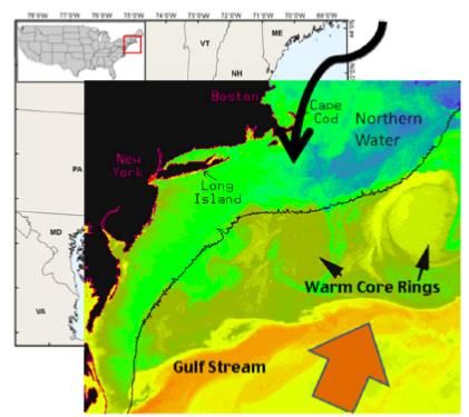
RI Ocean SAMP Case Study Summary Report
Close relationship between state and federal agencies in developing and implementing
the Ocean SAMP.
Approval of the Geographical Location Description for federal waters in the Ocean SAMP
area, effectively rendering the Ocean SAMP the fundamental regulatory instrument for
specific developments proposed for the entire area.
Support for the plan by the Narragansett Indian Tribe, a federally recognized tribe of
the Federal Government.
Formation of the Fisherman and Habitat Advisory Boards as two formally recognised
organs that must be consulted on any development in the Ocean SAMP area.
With respect to coordination with neighbouring states, other than informal exchanges and
mutual learning, the Ocean SAMP has contributed to the identification and design of the Area of
Mutual Interest (AMI) governed through a Memorandum of Understanding between RI state and
the Commonwealth of Massachusetts based on the regulations and policies of the Ocean SAMP.
It was found that cross-border collaboration between RI and neighbouring states during the
development and implementation of the RI Ocean SAMP was and still is relatively limited.
Despite recurrent exchanges, there are few cases of formal cross-border collaboration in marine
planning. In this context, the NE Regional Plan can be considered to be using MSP as a process
to strengthen institutional relationships and coordinate planning decisions involving mainly
federal agencies at different levels.
Lessons learned from the Ocean SAMP in general include:
Having a clear driver generated and helped to keep the momentum for the planning
effort, as well as focus the minds and actions of the many actors involved.
A competent, engaged and multi-faceted team with a broad scope of skills and
knowledge is necessary to deal with complex and lengthy marine planning processes.
The extent and outcomes of the interactions between different organisations engaged in
planning depends on the relationships between the individuals involved, especially those
in positions of authority.
Because marine planning implies making important decisions that can affect the lives of
people negatively, those leading the planning need to ensure objectivity and impartiality
of process and deliberations, so that they can gain the trust of plan stakeholders.
A clear process that was regularly communicated to all involved parties helps generate
commitment and a sense of urgency that enables a planning process to keep to
schedule and maintain the commitment of those involved.
Planning is likely to yield better results and be easier to implement if it has the backing
of affected stakeholders.
Open, transparent and inclusive processes are a pre-condition for building trust and
gaining the support of stakeholders who expect to participate in planning and
implementation processes.
Elaborating complicated systems for progress monitoring and periodic evaluation that
are too demanding and do not address the needs of managers during implementation is
likely to be a worthless exercise and create expectations among stakeholders that end
up not being met.
If a plan is to be implementable, it needs to have clear mechanisms that commit specific
actors to a given course of action.
Lessons learned from the Ocean SAMP about cross-jurisdictional collaboration include:
Cross-jurisdictional marine planning needs a clear and strong driver.
Working with existing policy and regulatory frameworks simplifies and shortens the
planning process.
Study on International Best Practices for Cross-border MSP Page | xRI Ocean SAMP Case Study Summary Report
Marine planning can be an instrument for regulatory and management harmonisation
across borders.
Cross-jurisdictional collaboration benefits from regularly engaging all stakeholders in the
planning process, irrespective of jurisdiction.
The planning and implementation authority needs to be accepted by stakeholders in the
different jurisdictions.
Planning is a tool for cross-jurisdictional exchanges and learning.
Study on International Best Practices for Cross-border MSP Page | xiRI Ocean SAMP Case Study Summary Report
1. INTRODUCTION
The ‘Study on international best practices for cross-border Maritime Spatial Planning’ (MSP)
(hereafter referred to as ‘the Project’) has been designed to compile and assess experiences of
approaches to MSP, in order to assist the European Commission (EC) and its member states in
implementing the EU MSP Directive.1 The Project’s second objective involves conducting four
case studies from international locations outside of Europe, to identify good practices that are
relevant for the implementation of the MSP Directive, with a particular focus on cross-border
cooperation. These case studies are: (i) Rhode Island/New England, (ii) China/Xiamen, (iii) the
Southern Ocean and (iv) the Coral Triangle.
The Rhode Island Ocean Special Area Management Plan (RI Ocean SAMP) case study was
selected because of its relative maturity, being one of the few non-European MSP processes that
has been formally adopted and progressed to implementation. Also relevant for the Project are
the facts that it is generally recognised as a successful case, is exceptionally well documented,
and enables the investigation of inter-state and state-federal collaborations in marine planning.
This case study does not address MSP across national borders, as there are no joint planning
initiatives with neighbouring Canada. Instead, it explores issues of planning across jurisdictional
borders. Firstly, it explores the relationship between RI state and federal planning and
management, since the area of the Ocean SAMP straddles the state-federal maritime boundary.
Secondly, it briefly considers the parallel process that took place in Massachusetts (MA) through
the development of the MA Ocean Plan, and whether and how this process articulated with the
one taking place in RI. Finally, this case study also looks into the development of the Northeast
Ocean Plan, which commenced after the adoption of the RI Ocean SAMP and MA Ocean Plan, in
2012, and brings together six New England states, nine federal agencies and six federally
recognized tribes.
This case study has been supported by the Project’s regional expert, Jennifer McCann, Director
of US Coastal Programs at the University of Rhode Island Coastal Resource Center (CRC-URI),
who was responsible for public outreach and policy development in the RI Ocean SAMP, and
who facilitated access to relevant literature, set up interviews with key stakeholders and
individuals involved in the development of the Ocean SAMP, and contributed to data gathering
and analysis.
This document presents a summary of the RI Ocean SAMP case study, presenting the key
findings, conclusions and lessons learned, according to the structure of the analytical framework
developed for the Project. Together with the reports for the other three case studies, it is one of
the inputs to the consolidated analysis and the final report of the Project.
1
Directive 2014/89/EU of the European Parliament and of the Council of 23 July 2014 establishing a frame-
work for maritime spatial planning
Study on International Best Practices for Cross-border MSP Page | 12RI Ocean SAMP Case Study Summary Report
2. METHODOLOGY
In order to ensure consistency in the description and assessment of the four case studies, and
enable the comparison of very distinct MSP initiatives, the Project developed a common
analytical framework for all four case studies (see Annex 1). In this framework, MSP attributes
have been organised into eight different sections, namely: (1) Context, (2) Driver, issues and
goals, (3) Overview of the MSP, (4) Scope and design of the MSP, (5) Collaboration and
consultation in the MSP planning phase, (6) Features of the MSP process implementation phase,
(7) Implications of the application of MSP in areas beyond national jurisdiction, and (8)
Outcomes and lessons learned. Section 7 has not been included in the RI Ocean SAMP case
study, as the entire Ocean SAMP area falls within national jurisdiction.
Each of the MSP attributes have been investigated by means of both descriptive – termed ’facts
of the matter’ (FoM) – and assessment – termed ‘to what extent’ – questions. The data for
answering both types of questions were collected through a review of literature and key
informant interviews conducted in the period July - October 2016:
a) Literature review
Peer-reviewed and grey literature, identified by the Regional Expert and through online
searches, was reviewed with the primary aim of answering the FoM questions in the analytical
framework. To a lesser extent, the literature review enabled the team to address some of the
assessment questions.
b) Key informant interviews
A total of 21 interviews, involving 27 participants were conducted between 28 September and 7
October 2016 in the states of Rhode Island, Massachusetts and New Hampshire. With the
exception of one interview, all 21 interviews were conducted face-to-face.
The interviewees were selected based on their engagement in and knowledge of the RI Ocean
SAMP, the MA Ocean Plan and/or the Northeast Regional Planning processes, and included: 2
State agencies: RI Coastal Resources Management Council (CRMC), RI Department of
Environmental Management (DEM), and the MA Office of Coastal Zone Management
(CZM)
Federal agencies: National Oceanic and Atmospheric Administration (NOAA), United
States Army Corps of Engineers (USACOE), US Navy, and the US Coast Guard;
Sector representatives: Commercial and recreational fishing, tourism, offshore wind
developers, recreational sailing, and representatives of Block Island residents
Academia: URI Graduate School of Oceanography, and URI-CRC
NGOs: Conservation Law Foundation, The Nature Conservancy, RI Commercial Fisheries
Research Foundation, and Ocean View Foundation.
Six out of the 21 interviews were conducted with more than one participant, and all except
three interviews were attended by the regional expert or another URI-CRC representative.3
A semi-structured interview format based on the analytical framework was employed to gather
data, ensuring a degree of comparability across interviews, while allowing for the investigation
of themes and issues specific to each particular interviewee. The interviews were all led by the
case study lead, Gonçalo Carneiro, with support from Sara Méndez and Jennifer McCann.
All participants were given a hard copy of the “participant information sheet” and “consent
form”, the latter of which was signed by 23 of the 27 participants, providing consent for an
2
The full list of participants and the schedule of interviews can be found in Annex 2.
3
This representative was Dr Tiffany Smythe, who accompanied the case study team to Block Island on 28
September 2016.
Study on International Best Practices for Cross-border MSP Page | 13RI Ocean SAMP Case Study Summary Report
interview audio recording and the use and storage of interview data as described in the
information sheet. The data of those who declined to sign the consent form was used in this
report, but their names and professional affiliation have not been disclosed in this report.
All interviews were summarised in writing and shared with participants for accuracy check, and
this information was then used to produce the scores for the assessment questions for the case
study.
In addition to the interviews, the team attended a meeting of the Northeast Regional Ocean
Council (NROC) held in New Hampshire on 3 October 20164, which provided an opportunity to
observe part of the deliberations taking place at the regional level and to engage with some of
the actors involved in the Northeast Regional Planning process. The team delivered a short
presentation of the Project, including some initial findings from the RI Ocean SAMP, and
gathered some feedback from the audience. Finally, a public briefing on the Project and
preliminary case study results was held at CRC-URI on 7 October 2016, which enabled the team
to discuss elements of the case study with an audience of URI staff, Ocean SAMP stakeholders
and students from a RI high school.
The data collected through the literature review, the interviews and the two events in New
Hampshire and URI-CRC were used to describe and assess the attributes of the RI Ocean SAMP
and distil the key conclusions and lessons learned presented in this document.
4
Background material and the agenda of the NROC meeting are available at
http://northeastoceancouncil.org/wp-content/uploads/2016/09/NROC-Council-Meeting_Oct2016_BP.pdf
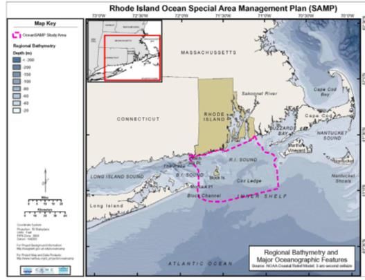
Study on International Best Practices for Cross-border MSP Page | 14RI Ocean SAMP Case Study Summary Report 3. KEY FINDINGS The RI Ocean SAMP covers an area of approximately 3,800 km2 extending from 500 ft (approx. 152m) seaward of the RI coastline to 30 nm offshore (cf. Figure 1, dashed line). Since RI’s state waters only extend 3 nm offshore from the coastline (including the water surrounding Block Island), the area of the plan is actually mostly made up of federal waters, which lie beyond the reach of state jurisdiction. This section summarises the key attributes of the area of the SAMP. 3.1. Context 3.1.1. Natural environment Rhode Island’s offshore region is ecologically unique. It comprises shallow, nearshore continental shelf waters that are dynamically connected to Narragansett Bay to the north, Buzzards Bay to the east, Long Island Sound to the west, and the Atlantic Ocean to the south (cf. Figure 1). Figure 1 - Bathymetry and major oceanographic features in southern New England (source: RICRMC, 2010, ch.2, p.7) (Not to Scale). Study on International Best Practices for Cross-border MSP Page | 15
RI Ocean SAMP Case Study Summary Report

Figure 2 - Schematic representation of northern cold water currents, southern warm current and
Gulf Stream warm core rings entering the Ocean SAMP area. (Source: RICRMC, 2010, ch.2, p.26)

This area is characterized by high biodiversity, combining northern cold water species and
southern warm water species (Smythe et al. 2016; cf. Figure 2). It contains a diversity of
benthic habitats supporting rich marine flora and faunal assemblages. Nearshore and offshore
marine areas also harbour different species of marine mammals, and support a large number of
marine birds.

As elsewhere, Rhode Island’s marine and coastal environments are expected to experience
changes due to global climate change. Impacts observed in the Ocean SAMP area over the last
century include an increase in both air and sea temperature, a rise in sea level, an increase in
average precipitation and an increase in the severity of storms. Future projections of climate
change include sea water warming and possible changes to offshore ocean circulation patterns,
stratification, nutrient distribution, and plankton productivity. Alteration of these variables is
expected to affect the ecological functioning of the Ocean SAMP region, create stress on marine
plants and animals, shift geographic ranges of commercially important fish species northward,
and change the timing of biological events (RICRMC 2010, ch.3)

3.1.2. Socio-economic uses
The nearshore and offshore waters in the entire region, including off RI, have been used by
humans since the time of the earliest settlements, estimated at approx. 30,000 years ago by
the Narragansett people. Current uses include commercial and recreational fishing, shipping and
ports, naval operations, yacht racing, different types of marine recreation and offshore wind
energy, the most recent sector. Some of these activities, such as fisheries and maritime
transportation have been carried out for centuries, whereas others, such as marine salt
production, were of great importance in the past but have now disappeared as society changed.
Table 1 presents employment and economic value figures for the most important maritime
activities taking place in Rhode Island waters.5 Figures 3, 4 and 5 depict patterns of use of the
Ocean SAMP area by different economic activities.

5
    Data for fisheries concern landings in Rhode Island harbours, from captures made beyond state waters and
      the Ocean SAMP boundaries.

Study on International Best Practices for Cross-border MSP                                        Page | 16
RI Ocean SAMP Case Study Summary Report
Table 1 - Employment and economic value of key maritime activities in Rhode Island.
Maritime activities Employment and Economic value
In 2013, landings from Rhode Island’s commercial fisheries generated USD 86
Commercial million in revenue excluding imports, the state’s fishing industry supported over
fishing 5,400 jobs, over USD 304 million in sales, and over USD 111 million in income
(NOAA 2013).
Seafood Employment: 605 (2005)
processing and
wholesale Economic value: USD 69 million (NOAA/NMFS 2008, cited in McCann et al. 2013)
A 2007 study estimated that 182,000 anglers fish in Rhode Island’s waters each
year, making 1.2 million trips; 50% of these anglers come from out of state
(Ninigret Partners 2007). Data from 2015, however, suggests that the number of
Recreational trips has declined to just over 1 million, although fishing participation increased by
fishing 1.15% (National Marine Fisheries Service, Fisheries Statistics Division, pers. comm.
2015a; 2015b).
In 2013, Rhode Island’s recreational fisheries supported over 2,500 jobs, over USD
226 million in sales and over USD 102 million in income (NOAA 2013).
In 2012, the Rhode Island cluster of marine businesses that supports recreational
Recreation and boating and yacht racing in this region supported 14,700 jobs, USD 2.6 billion in
tourism sales and USD 598 million in wages (Planning Decisions, Inc, 2014). USD 1.92
billion spent in Ocean SAMP adjacent counties (IHS 2014)
Shipping and ports In 2013, marine transportation alone accounted for over 2,500 jobs and USD 180
operations million in wages in RI state (National Ocean Economics Program 2015)
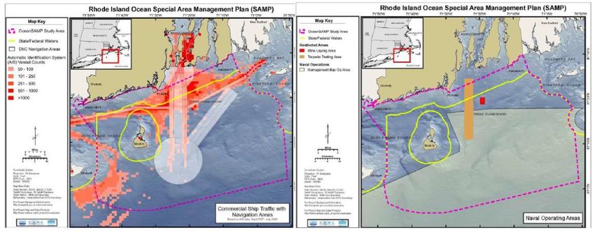
Figure 3 - Maritime traffic with navigation zones (left) and naval operating areas (right) in the
Ocean SAMP area (Not to Scale) (Source: RICRMC, 2010, ch.7)
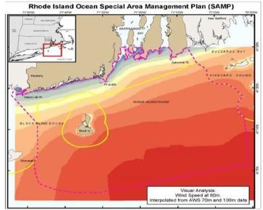
Study on International Best Practices for Cross-border MSP Page | 17RI Ocean SAMP Case Study Summary Report Figure 4 - Submarine utilities (left) and recreational boating cruising routes in the Ocean SAMP area (Not to Scale) (Source: RICRMC, 2010, ch. 6 & 7) Figure 5 - Fixed gear (left) and mobile gear (right) fishing areas in the Ocean SAMP area based on qualitative input (Not to Scale) (Source: RICRMC, 2010, ch.5) Of particular relevance for the Ocean SAMP is that the entire offshore US Northeast region is characterized by strong and steady winds, which makes it very attractive for offshore wind development (cf. Figure 6). The favourable wind conditions and bathymetry, and the proximity to one of the largest economic region in the US contributed to this area being selected for the siting of the first offshore wind farms in the US. As discussed in the next section, this was the key driver for the elaboration of the Ocean SAMP. Study on International Best Practices for Cross-border MSP Page | 18
RI Ocean SAMP Case Study Summary Report

Figure 6 - Average wind speeds at 80m above sea level in the Ocean SAMP area (Source:
RICRMC, 2010, ch.8)

3.1.3. Governance of coastal and marine areas
Since the area of the Ocean SAMP includes RI state and federal waters, its resources and uses
are subject to both state and federal statutes, regulation and policies (see Annex 3). Some of
the latter apply both to federal and state waters, and federal authorities in some instances
delegate authority for their enforcement to the state. This combined state-federal governance
regime is a complex one, and this section only synthesises its most pertinent elements. In doing
so, it also attempts to provide a sense of the diversity of regulatory procedures that need to be
observed by any entity – public or private – when proposing to undertake any activities at sea.6

The Submerged Lands Act of 1953 gives coastal states jurisdiction over marine waters from the
mean high-water mark to 3 nm offshore.7 This act grants coastal states "title to and ownership
of the lands beneath navigable waters within the boundaries of the respective states, and the
natural resources within such lands and waters." Although the federal government retains "the
power to regulate commerce, navigation, power generation, national defence, and international
affairs throughout state waters"8 the act underscores that the federal government does not
have "the rights of management, administration, leasing, use and development of the lands and
natural resources which are specifically recognized, confirmed, established, and vesting in and
assigned to the respective states […].”9 This means that states have the exclusive right to
manage and exploit state marine waters, including the granting of exploration and exploitation
licenses.

At the same time, the 1971 Act enabling the Coastal Resources Management Council (CRMC)
Authority, declares the state to be responsible for protecting the public’s interest in all state
submerged lands. In doing so, the state preserves public rights such as those to fishing,
commerce or navigation in state waters and submerged lands.

6
    For a compendium of regulations applicable to coastal and marine spatial planning in the US, refer to
       National Ocean Council (2011).
7
    Except in the state of Texas, Puerto Rico and the west coast of Florida, where state jurisdiction extends to
       9 nm.
8
    2004 U.S. Commission on Ocean Policy, An Ocean Blueprint for the 21st Century, p.71.
9
    Submerged Lands Act, Section 1314.

Study on International Best Practices for Cross-border MSP                                             Page | 19
RI Ocean SAMP Case Study Summary Report
The CRMC has been delegated the exclusive authority for leasing and licensing of submerged
lands, and has the primary responsibility for planning and managing the state’s coastal and
marine resources. It does so through a diversity of policies and regulations, which make up the
federally-approved RI Coastal Resources Management Programme (RI CRMP), and are compiled
in the (so-called) ‘Red Book’. Two salient instruments in the RI CRMP are the SAMPs (see below)
and a typology of waters under CRMC jurisdiction into six categories10 linked to their uses and
qualities (cf. CRCM, 2012, Section 200). With the exception of a small area abutting the Point
Judith-Galilee, all marine waters in the area of the SAMP fall under category 4 ‘Multipurpose
Waters’, relative to which the goal of the CRMC is to “maintain a balance among the diverse
activities that must coexist”, noting that the “changing characteristics of traditional activities
and the development of new water-dependent uses shall, where possible, be accommodated
[…].” (CRMC 2010, p.2, Sec.200.4)11 As described later, the Ocean SAMP led to the modification
of the policies, standards and definitions for Type 4 waters.
The Rhode Island Department of Environmental Management (RI DEM) 12 cooperates with the
CRMC in various aspects of coastal management, with responsibility over programmes affecting
coastal resources, fish and wildlife, water resources and watersheds among other environmental
resources.
Also of relevance, the 1972 Coastal Zone Management Act (CZMA) provides the framework for
state coastal management programmes, under which states have the authority to prepare
special area management plans (SAMPs). SAMPs are management strategies for specific areas
designed to protect natural resources, coastal-dependent economic activities, life and
property.13 An important function of SAMPs is that they enable the RI Coastal Programme to
extend its remit to areas beyond the CRMC’s primary regulatory boundary (i.e. 200ft, approx.
60m inland from the high water mark), usually to address watershed management issues (see
Appendix 3).
A very important element of the CZMA is (so-called) ‘federal consistency review’, a mechanism
for ensuring that federal agency actions or federal license activities align with policies and
regulations of federally-approved state coastal programmes (see Appendix 3).
States with federally approved coastal programmes may activate the (so-called) interstate
consistency provision under NOAA Federal Consistency Regulations. Interstate consistency
applies only to federal authorisations or actions, and allows states to review:
Federal authorisations and actions occurring inside or outside a state’s coastal zone,
including federal waters (i.e. beyond 3 nm from the shoreline) that potentially affect any
use or natural resource of a state’s coastal zone – so-called ‘CZMA federal consistency’;14
10
Type 1 (Conservation areas), Type 2 (Low-intensity recreational and residential uses), Type 3 (High
intensity boating), Type 4 (Multipurpose waters), Type 5 (Commercial and recreational Harbours) and
Type 6 (Industrial waterfronts and commercial navigation channels)
11
The mentioned waters off Point Judith-Galilee are classified as Type 2 ‘Low-Intensity Use’ and in the
entrance to the Port of Galilee, Type 5 ‘Recreational and Commercial Harbours’. Along the entire
coastline, the first 500 ft from the high-water mark are classified as Type 1 ‘Conservation Areas’. Recall
in this respect that the area of the Ocean SAMP starts 500 ft offshore.
12
For more information on DEM activities see http://www.dem.ri.gov
13
In the CZMA, a SAMP means “a comprehensive plan providing for natural resource protection and
reasonable coastal-dependent economic growth containing a detailed and comprehensive statement of
policies; standards and criteria to guide public and private uses of lands and waters; and mechanisms
for timely implementation in specific geographic areas within the coastal zone.” (CZMA of 1972, 16
U.S.C. § 1453. Definitions [Section 304], no.17)
14
Such authorisations and actions include: i) federal agency activities, conducted by or on behalf of a
federal agency; ii) federal license or permit activities, activities proposed by a non-federal entity subject
to a federal authorisation; iii) Outer Continental Shelf Oil and Gas Plans, for the exploration,
development or production of oil and gas in federal waters, pursuant to the Outer Continental Shelf
Lands Act; and iv) federal financial assistance activities, an application by a state agency or local
government for federal financial assistance.
Study on International Best Practices for Cross-border MSP Page | 20RI Ocean SAMP Case Study Summary Report
Federal authorisations and actions occurring in one state that potentially affect the uses and
resources of another state’s coastal zone – so-called ‘Interstate consistency’.
In a standard consistency assessment, the onus lies with the affected state to demonstrate the
potential impact of a federal activity in order to justify the review. The onus can, however, be
reversed by means of a so-called Geographic Location Description (GLD), in which a state
submits to NOAA a list of federal activities in a given ‘geographic location’ (in federal or another
state’s waters) potentially affecting marine uses and resources in that state’s waters. If
approved, the GLD obliges federal agencies to report to the affected state the activities planned
and report the anticipated effects. As will be discussed later, the RI CRMC secured a GLD for the
entire area of the Ocean SAMP (extending approx. 27 nm into federal waters), effectively
granting it greater control over certain developments in its entire area.15
The interstate consistency clause does not formally allow one state to interfere with the
sovereign rights of another, since it only applies to federal, and not state-led actions. However,
because most developments at sea require federal permits, this clause is frequently regarded as
a mechanism for states to threaten one another with legal action against such developments.
On a more positive note, it is a mechanism for encouraging consultation and coordination
between states and between the state and federal levels in matters concerning the use of
coastal and marine areas or resources.
For more information on federal and state statutes, regulations and policies of relevance for the
Ocean SAMP please refer to Annex 3.
3.1.4. Cross-jurisdictional collaboration in coastal and marine planning
There is not a tradition of interstate collaboration in marine and coastal planning. States have
often elaborated their respective coastal management programmes and related acts in relative
isolation from one another. The same is true of most other areas of policy, such that
neighbouring states can, and sometimes do, have very different legal regimes and
administrative structures. The states’ coastal management programmes are therefore designed
within state-specific legal/institutional frameworks that are seldom compatible.
There is no provision in the federal CZMA specifically preventing states from collaborating across
borders. It is equally true, however, that there is no incentive for cross-border collaboration in
either the act or the federal Coastal Zone Management Program administered by NOAA.
Because state marine planning tends to be conducted under the aegis of state coastal
management programmes, so far they have had little or no consideration of cross-border
issues.16 On the other hand, the fact that the state coastal programmes follow the same set of
standards imposed by the CZMA ensures a large degree of compatibility between the coastal
programmes of different states. Inter-state collaboration might therefore be perceived as
unnecessary for the sake of ensuring a sufficient degree of compatibility.
Interstate collaboration on matters affecting their regulatory/institutional framework typically
involves states entering into a (so-called) ‘interstate compact’, a voluntary agreement for
solving specific common problems and that becomes part of the law of each state. Compacts
exist for a variety of policy domains; within environmental policy they have been used for states
to cooperate on issues of freshwater management, pollution control, wildlife protection and
15
The GLD only pertains to activities justified, e.g. disposal dumping could not be included in the RI Ocean
SAMP GLD
16
The marine planning processes in San Francisco Bay described in Smythe, McCann et al. (2016) are two
cases of federally-led efforts that were not conducted within an existing state coastal management
programme.
Study on International Best Practices for Cross-border MSP Page | 21RI Ocean SAMP Case Study Summary Report
regional fisheries management, among others.17 Compacts always lead to the creation of an
administrative body – usually a commission, and require congressional approval, which renders
them relatively burdensome efforts. While no compacts exist today specifically for coastal or
ocean management, in 1990 the state of Rhode Island and the Commonwealth of Massachusetts
enacted the Bay State – Ocean State Compact to “study, develop and make recommendations
about the environmental and economic aspects of Narragansett Bay and Mount Hope Bay.” 18
In the specific case of the RI Ocean SAMP there has been no actual cooperation in ocean
planning with the neighbouring states of Connecticut, New York and Massachusetts. The former
two had, at the time of initiation of the Ocean SAMP process (Spring-Summer 2008) no ocean
planning efforts19 Massachusetts, on the other hand, was at the time producing its first Ocean
Management Plan, which was promulgated on 31 December 2009, approx. ten months before
the formal approval of the RI Ocean SAMP. Interviewees from the RI and MA coastal
management agencies consulted for this study mentioned three main reasons for the lack of
cooperation between the two states: firstly, the coastal programmes of the two states had
important regulatory and administrative differences that would have made cooperation
cumbersome from a legal / institutional perspective; secondly, the two states had different
approaches to planning, starting with the decision of RI to include federal waters in the planning
area, something that MA decided not to, in part as a result of the controversy surrounding the
Cape Wind project that was being proposed for federal waters in Nantucket Sound (cf. Figure
7); thirdly, and possibly most importantly, the two states were at the time competing for
offshore wind investments, which would be the first in the country. As discussed in the next
section, the RI Ocean SAMP in particular originated in response to an explicit gubernatorial
mandate to increase renewable energy production from offshore sources, and hence there was
little – if any – incentive to engage in a protracted cooperation agreement for ocean planning
with Massachusetts, where offshore wind developments taking place in federal waters at the
time were all but problematic.
17
The Atlantic States Marine Fisheries Commission mentioned in the previous section has been established
by a compact ratified by the Atlantic coast states (except S. Carolina) and approved by the US Congress
in 1942. Cf. www.asmfc.org and http://apps.csg.org/ncic/Compact.aspx?id=15, accessed 30 Nov 2016.
18
Bay State – Ocean State Compact, art.1. Available online at http://apps.csg.org/ncic/PDF/Bay%20State-
Ocean%20State%20Compact.pdf, accessed 30 Nov 2016.
19
New York has been working on its Ocean Action Plan since 2012, which is currently still in draft form.
Interestingly, the draft plan document does not contain a single reference to the RI Ocean SAMP,
despite sharing a long border with the area of the SAMP, and adopting a similar approach of including
federal waters within the planning area (NY State DEC 2015).
Study on International Best Practices for Cross-border MSP Page | 22RI Ocean SAMP Case Study Summary Report
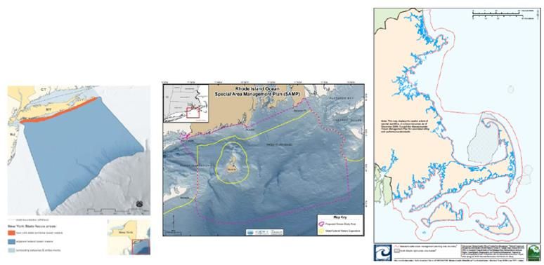
Figure 7 - Geographic scope of the NY Ocean Action Plan, the RI Ocean SAMP and the MA Ocean
Management Plan (Sources: NY State DEC, 2015; CRMC, 2012; Commonwealth of Massachusetts,
2009).
Interestingly, in 2006 the RI CRMC had led an attempt to create a multi-state ocean SAMP
involving the states of New York, Connecticut and Massachusetts, under the aegis of the
Northeast Regional Ocean Council (NROC).20 This effort bore no fruits in terms of interstate
marine planning, but for some time at least resulted in the establishment of the (so-called)
Southern New England/New York Ocean Council working group within NROC, with the aims of
prioritising issues requiring coordination among the four states and research mechanisms to
enhance shared resources (CRMC 2012).
Cooperation in marine planning and management across state-federal borders is complex and
diversified, given the large number of statutes and agencies involved on each side of the border.
The fact that states have different legal and administrative frameworks means that state-federal
dynamics vary between states, and except when states have some form of interstate organ –
for example a commission established by an interstate compact – federal agencies usually have
different arrangements with agencies in different states. A central provision that is common to
all states having a federally-approved coastal management programme and which shapes much
of the state-federal cooperation in marine and coastal management is the federal consistency
review, discussed above. It creates mutual obligations regarding consultation and can be said to
have assisted state and federal authorities in avoiding serious – and legally paralysing –
disagreements on the use of offshore areas and resources.
Finally, it is worth alluding briefly to the Northeast Ocean Planning process as a further
dimension of cross-border collaboration in marine planning involving the state of RI. In 2010,
President Barack Obama issued an executive order establishing a National Policy for the
“Stewardship of the Ocean, Our Coasts and the Great Lakes”21, to promote sustainable
development of these three environments through inter alia the implementation on Coastal and
Marine Spatial Planning. The President tasked federal agencies, through the formation of
regional planning bodies (RPB), with the responsibility of developing regional ocean plans.
Being a presidential executive order, tribal and state participation was voluntary, but in New
England, the six New England states, six federally recognized tribes, nine federal agencies, the
20
The NROC, formed in 2005, is a state and federal partnership that facilitates the New England states
(Maine, New Hampshire, Vermont, Massachusetts, Rhode Island, and Connecticut), federal agencies,
regional organizations, and other interested regional groups in addressing ocean and coastal issues that
benefit from a regional response. More information available at: http://northeastoceancouncil.org/
21
Available at: http://energy.gov/sites/prod/files/nepapub/nepa_documents/RedDont/Req-
EO13547watersteward.pdf
Study on International Best Practices for Cross-border MSP Page | 23You can also read