MCDONALDS SWAMP ENVIRONMENTAL WATER MANAGEMENT PLAN - MILLENNIUM DROUGHT REPORT
←
→
Page content transcription
If your browser does not render page correctly, please read the page content below
McDonalds Swamp
Environmental Water Management Plan
DOCUMENT CONTROL
Document History and Status
Version        Date Issued         Prepared By              Reviewed By                                  Date Approved
1              6 March 2015        Genevieve Smith          Louissa Rogers                               25 March 2015
2              1 April 2015        Genevieve Smith          Emer Campbell                                16 April 2015
3              17 April 2015       Genevieve Smith          Suzanne Witteveen and Susan Watson (DELWP)   13 May 2015
4              12 June 2015        Genevieve Smith          Emer Campbell                                30 June 2015
5              30 June 2015        Genevieve Smith          Emer Campbell                                FINAL

Distribution
Version        Date                 Quantity                Issued To
1              6 March 2015         Internal                Louissa Rogers
2              1 April 2015         Internal                Emer Campbell
3              17 April 2015        External                Suzanne Witteveen and Susan Watson (DELWP)
4              12 June 2015         Internal                Emer Campbell
5              30 June 2015         External                Suzanne Witteveen and Susan Watson (DELWP)

Document Management
Printed:                         30 June 2015
Last saved:                      30 June 2015 04:17 PM
File name:                       McDonalds Swamp - EWMP.docx
Authors:                         Genevieve Smith
Name of organisation:            North Central CMA

Name of document:                McDonalds Swamp EWMP

Document version:                Version 5
SharePoint link:                 McDonalds Swamp - EWMP Final

For further information on any of the information contained within this document contact:
North Central Catchment Management Authority
PO Box 18
Huntly Vic 3551
T: 03 5448 7124 F: 03 5448 7148
E: info@nccma.vic.gov.au
www.nccma.vic.gov.au

© North Central Catchment Management Authority, 2015
This is a working document, compiled from the best available information. It will be subject to revision in the
future as new information becomes available.
This publication may be of assistance to you, but the North Central Catchment Management Authority and its
employees do not guarantee that the publication is without flaw of any kind, or is wholly appropriate for your
particular purposes and therefore disclaims all liability for any error, loss or other consequence which may
arise from you relying on information in this publication.
Please cite this document as: North Central CMA, 2015. McDonalds Swamp Environmental Water
Management Plan. North Central Catchment Management Authority, Huntly, Victoria.
EXECUTIVE SUMMARY
The McDonalds Swamp Environmental Water Management Plan (EWMP) sets out the long-term objectives
for the priority environmental values of McDonalds Swamp, in the Barr Creek sub-catchment of the Loddon
River Basin. The EWMP is an important part of the Victorian Environmental Water Planning Framework. It
provides the five to ten year management intentions, based on scientific information and stakeholder
consultation, which can be used by the respective agencies; North Central Catchment Management
Authority (CMA), Department of Environment, Land, Water and Planning (DELWP) and the Victorian
Environmental Water Holder (VEWH); for both short and longer-term environmental water planning.
This EWMP is not a holistic management plan for the wetland, but is focused on environmental water
management so that McDonalds Swamp can continue to provide environmental, social, cultural and
economic values for all users. Actions such as infrastructure upgrades and pest plant and animal works are
documented as complementary to environmental water management in this EWMP.
The following components are the main sections featured in the McDonalds Swamp EWMP. A summary of
the main conclusions to facilitate appropriate environmental water management into the future are
summarised below.
Hydrology and system operations
A key threat to the long-term health of McDonalds Swamp is the alterations that have been made to the
watering regime over time. Historically McDonalds Swamp operated as an ephemeral wetland, experiencing
periodic wetting and drying phases in response to high flow in the Piccaninny Creek. However, modifications
to the catchment through land use changes have significantly altered its watering regime. In the 1960s,
Piccaninny Creek was dredged and deepened, disconnecting McDonalds Swamp from natural flooding. The
wetland received channel outfalls from the irrigation system, and also received rainfall rejection flows,
irrigation drainage flows from adjacent land, and run-off from within the local catchment.
Due to increased efficiencies in irrigation infrastructure and practices, and declining regional rainfall
volumes, the volume of channel outfalls decreased throughout the 1990s and early 2000s. The wetland’s
hydrology shifted again from an almost permanent watering regime to an annual wetting/drying regime,
with the wetland drying out completely during 2006-07 and 2008-09 as a result of the drought (North
Central CMA 2010). In response to the decreased availability of water, environmental water has been
delivered intermittently to the wetland from 1998 onwards.
Water dependent values
McDonalds Swamp is a wetland of regional significance, largely due to the habitat values provided by the
relative diversity of vegetation that it provides to numerous waterbirds (including threatened and migratory
species), frogs and turtles. In particular, large numbers of waterbirds utilise the wetland for feeding and
breeding including endangered species such as the Australasian Bittern (Botaurus poiciloptilus). The wetland
also supports a number of important plants and vegetation communities including young River Red Gums
(Eucalyptus camaldulensis), patches of lignum, and emergent and aquatic plants.
Ecological condition and threats
Although land use change has impacted on the duration, timing and frequency of inundation at McDonalds
Swamp, the wetland is currently considered to be in good health. Waterbirds continue to opportunistically
utilise the wetland during environmental watering events and localized rainfall events. Although the
structure and composition of native vegetation has departed from its pre-European state, the vegetation as
it exists now is considered to be in good health. Management focuses on providing conditions that facilitate
River Red Gum growth and recruitment, and maintaining appropriate extents of diverse habitats.

McDonald Swamp Environmental Water Management Plan                                                     3
Management objectives
A long-term management goal has been defined for McDonalds Swamp:

 Management goal

 Maintain McDonalds Swamp as a temporary freshwater marsh with a diversity of aquatic vegetation and
 habitat types to support feeding and breeding requirements for a range of native waterbirds (including
 colonial nesting and migratory species), frogs and turtles.

The ecological objectives and hydrological objectives that sit under the long-term management goal for
McDonalds Swamp were informed by the McDonalds Swamp Environmental Watering Plan 2010 and other
technical investigations and were refined during the development of this EWMP.
Managing risks to achieving objectives
The threats to achieving the ecological objectives that are external to environmental water are identified by
this EWMP. These include proliferation and encroachment of native species such as Cumbungi (Typha spp.)
and Common Reed (Phragmites australis), as well as introduced species (i.e. foxes and rabbits).
Environmental water delivery infrastructure
It is recommended that a supply point is retained to continue the supply of environmental water to
McDonalds Swamp. At present, only the western side of the wetland can be influenced with environmental
water, and it is recommended that options for watering the eastern side be investigated as this area
contains water-dependent vegetation communities.
Demonstrating outcomes
Monitoring is required to allow adaptive management of annual environmental watering (intervention
monitoring). It is also required to enable the CMA and VEWH to demonstrate the long-term outcomes of the
implementation of the McDonalds Swamp EWMP. As the State is currently developing the Wetlands
Monitoring Assessment Program (WetMAP), the McDonalds Swamp EWMP recommends a suite of
intervention and long-term monitoring activities that will meet the monitoring requirements.
Consultation
Key stakeholders, including DELWP, Parks Victoria and Goulburn Murray Water (GMW) were engaged during
the development of this EWMP. The community involved in the consultation phase of the McDonalds
Swamp EWMP also played a crucial role in advising the North Central CMA on its management of
environmental water at the wetland. This group comprised of local community, private landholders,
recreational, environmental and indigenous interest groups.
Knowledge gaps
The management actions in the McDonalds Swamp are based on the best available information. A number
of knowledge gaps have been identified during the development of the EWMP, particularly around
investigating options to enable delivery of environmental water to all areas of the wetland.

McDonald Swamp Environmental Water Management Plan                                                      4

ACKNOWLEDGEMENTS
The information contained in the McDonalds Swamp EWMP has been sourced from a variety of reports and
field inspections and from individual knowledge and expertise. The North Central CMA acknowledges the
assistance of the following people in preparing this EWMP:
   •   Suzanne Witteveen, Susan Watson, Mick Dedini, Department of Environment, Land, Water and
       Planning
   •   Ross Stanton, Goulburn-Murray Water
   •   Murray Thorson, Parks Victoria
   •   Damien Cook (Rakali Ecological Consulting)
   •   Charlie Gillingham (NRMC Member)
   •   Betty Waterson, Keith Stockwell (Birdlife Australia)
   •   Darryl Snowden and Mark Daley (Field and Game Australia)
   •   Ben Hall and Tuesday Browell (Community members)
   •   Emer Campbell, Michelle Maher, Bree Bisset, Louissa Rogers, Heidi Kleinert, and Phil Dyson (North
       Central CMA).

ACKNOWLEDGEMENT OF COUNTRY
The North Central Catchment Management Authority acknowledges Aboriginal Traditional Owners within
the region, their rich culture and spiritual connection to Country. We also recognise and acknowledge the
contribution and interest of Aboriginal people and organisations in land and natural resource management.

McDonald Swamp Environmental Water Management Plan                                                   5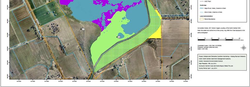
CONTENTS
  1. INTRODUCTION ................................................................................................................................................ 8
  1.1.     PURPOSE AND SCOPE ................................................................................................................................................ 9
  1.2.     DEVELOPMENT PROCESS.......................................................................................................................................... 10
  2. SITE OVERVIEW ...............................................................................................................................................12
  2.1.     SITE LOCATION ....................................................................................................................................................... 12
  2.2.     CATCHMENT SETTING .............................................................................................................................................. 12
  2.3.     LAND STATUS AND MANAGEMENT ............................................................................................................................. 13
  2.4.     WETLAND CHARACTERISTICS ..................................................................................................................................... 16
  2.5.     ENVIRONMENTAL WATER SOURCES ............................................................................................................................ 17
  2.6.     RELATED AGREEMENTS, LEGISLATION, POLICY, PLANS AND ACTIVITIES................................................................................ 18
  3. HYDROLOGY AND SYSTEM OPERATIONS .........................................................................................................21
  3.1.     WETLAND HYDROLOGY, WATER MANAGEMENT AND DELIVERY ........................................................................................ 21
     3.1.1.      Pre-regulation ........................................................................................................................................... 21
     3.1.2.      Post-regulation ......................................................................................................................................... 22
     3.1.3.      Groundwater/surface water interactions ................................................................................................. 23
     3.1.4.      Water Quality ........................................................................................................................................... 25
     3.1.5.      Environmental watering ........................................................................................................................... 26
  4. VALUES ...........................................................................................................................................................27
  4.1.     ENVIRONMENTAL VALUES ........................................................................................................................................ 27
     4.1.1.      Listings ...................................................................................................................................................... 27
     4.1.2.      Water-dependent fauna ........................................................................................................................... 27
     4.1.1.      Terrestrial fauna ....................................................................................................................................... 29
     4.1.2.      Vegetation communities and flora ........................................................................................................... 30
     4.1.3.      Wetland depletion and rarity ................................................................................................................... 32
     4.1.4.      Ecosystem function ................................................................................................................................... 32
  4.2.     SOCIAL VALUES ...................................................................................................................................................... 34
     4.2.1.      Cultural heritage ....................................................................................................................................... 34
     4.2.2.      Recreation................................................................................................................................................. 34
  4.3.     ECONOMIC............................................................................................................................................................ 34
  4.4.     CONCEPTUALISATION OF THE SITE .............................................................................................................................. 34
  4.5.     SIGNIFICANCE ........................................................................................................................................................ 35
  5. ECOLOGICAL CONDITION AND THREATS..........................................................................................................36
  5.1.     CONTEXT .............................................................................................................................................................. 36
  5.2.     CURRENT CONDITION .............................................................................................................................................. 36
  5.3.     CONDITION TRAJECTORY – DO NOTHING ..................................................................................................................... 38
  6. MANAGEMENT OBJECTIVES ............................................................................................................................40
  6.1.     MANAGEMENT GOAL .............................................................................................................................................. 40
  6.2.     ECOLOGICAL OBJECTIVES .......................................................................................................................................... 40
  6.3.     HYDROLOGICAL REQUIREMENTS ................................................................................................................................ 42
  6.4.     WATERING REGIME................................................................................................................................................. 44
  7. RISK ASSESSMENT ...........................................................................................................................................45
  8. ENVIRONMENTAL WATER DELIVERY INFRASTRUCTURE ..................................................................................50
  8.1.     PROPOSED CHANGES TO EXISTING INFRASTRUCTURE ..................................................................................................... 50
  8.2.     INFRASTRUCTURE CONSTRAINTS ................................................................................................................................ 51
  8.3.     OPERATION CONSTRAINTS ........................................................................................................................................ 51
  8.4.     INFRASTRUCTURE RECOMMENDATIONS ....................................................................................................................... 51
  9. COMPLEMENTARY ACTIONS............................................................................................................................52
  10.      DEMONSTRATING OUTCOMES ....................................................................................................................53
  10.1. INTERVENTION MONITORING .................................................................................................................................... 53
  10.2. LONG TERM MONITORING ........................................................................................................................................ 55
  11.      KNOWLEDGE GAPS AND RECOMMENDATIONS ...........................................................................................56
  12.      REFERENCES ................................................................................................................................................58
  13.      ABBREVIATIONS AND ACRONYMS ..............................................................................................................61

McDonald Swamp Environmental Water Management Plan                                                                                                                           6
TABLES
Table 1.    Roles and responsibilities for environmental water in McDonalds Swamp.................................. 14
Table 2.    Wetland characteristics of McDonalds Swamp ............................................................................. 17
Table 3.    Environmental water sources for McDonalds Swamp .................................................................. 18
Table 4.    McDonalds Swamp wetting/drying calendar (Source: Seasonal Watering Proposal for the Central
            Murray Wetland Complex 2015-16) .............................................................................................. 22
Table 5.    Significance of McDonalds Swamp and its associated species ..................................................... 27
Table 6.    Most recent bird breeding events at McDonalds Swamp (species of conservation significance are
            in bold) ........................................................................................................................................... 28
Table 7.    Significant water dependent fauna species recorded at McDonalds Swamp ............................... 29
Table 8.    Conservation status of EVCs at McDonalds Swamp ...................................................................... 31
Table 9.    Listed water dependent flora recorded at McDonalds Swamp .................................................... 31
Table 10.   Area, depletion and rarity of wetland classifications in the region .............................................. 32
Table 11.   Ecosystem function of McDonalds Swamp from a local and regional scale ................................. 33
Table 12.   IWC assessments for wetland EVCs at McDonalds Swamp against benchmark ........................... 37
Table 13.   Ecological objectives and their justifications for McDonalds Swamp ........................................... 41
Table 14.   Hydrological requirements for McDonalds Swamp ...................................................................... 43
Table 15.   Risk Matrix ..................................................................................................................................... 45
Table 16.   Possible risks and mitigation measures associated with environmental water delivery to
            McDonalds Swamp ........................................................................................................................ 46
Table 17.   Complementary actions to enhance the benefits of environmental watering ............................. 52
Table 18.   Required intervention monitoring for the implementation of the McDonalds Swamp EWMP ... 54
Table 19.   Required long-term condition monitoring for McDonalds Swamp............................................... 55
Table 20.   Knowledge gaps and recommendations for McDonalds Swamp .................................................. 56
Table 21.   Fauna species recorded within 1km buffer zone of McDonalds Swamp. ..................................... 66
Table 22.   Flora species recorded within 1km buffer zone of McDonalds Swamp. ....................................... 69
Table 23.   McDonalds Swamp assessed against the Murray Darling Basin Plan criteria for identifying an
            environmental asset ...................................................................................................................... 79

FIGURES
Figure 1.   Planning framework for decisions about environmental water management in Victoria.............. 9
Figure 2.   Location of McDonalds Swamp ..................................................................................................... 12
Figure 3.   Terrain of the Murray and Loddon River Floodplains ................................................................... 13
Figure 4.   McDonalds Swamp in the landscape ............................................................................................. 21
Figure 5.   Groundwater bores in the vicinity of McDonalds Swamp............................................................. 23
Figure 6.   Groundwater levels in bores near McDonalds Swamp ................................................................. 24
Figure 7.   Surface water and salinity levels within McDonalds Swamp as recorded by DPI between 1990
            and 2007 (North Central CMA 2010) ............................................................................................. 25
Figure 8.   Inflow points at McDonalds Swamp .............................................................................................. 50

McDonald Swamp Environmental Water Management Plan                                                                                                          7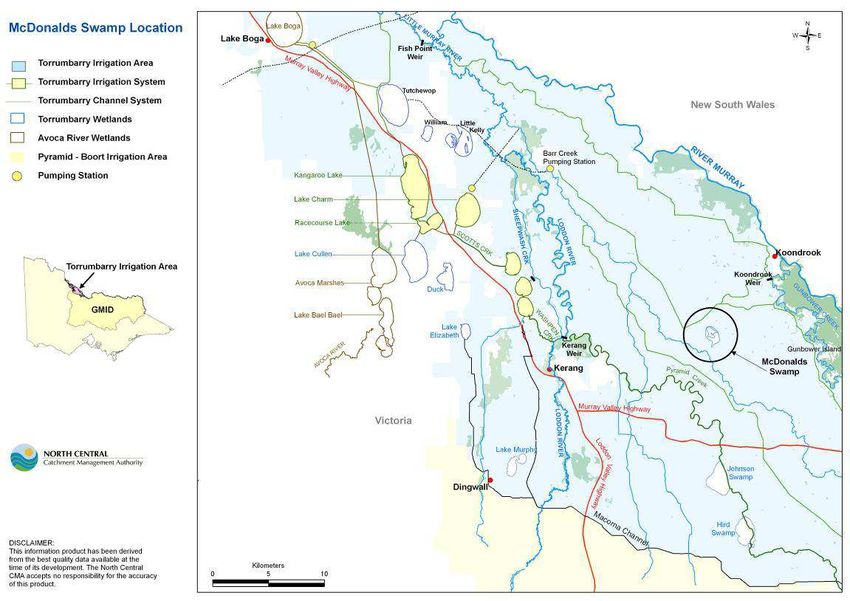
1. Introduction
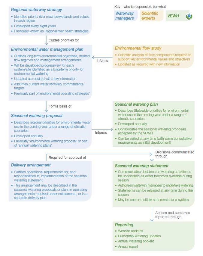
Management of environmental water is planned and implemented through a framework of key
documents. Figure 1 illustrates the strategies, scientific reports and operational documents required
for environmental water management in Victoria. The North Central Catchment Management
Authority (CMA) has recently developed the North Central Waterway Strategy 2014-2022 (NCWS)
which is an integrated strategy aimed at managing and improving the North Central CMA’s
waterways (rivers, streams and wetlands). The NCWS is guided by the Victorian Waterway
Management Strategy 2013 (VWMS) and the North Central Regional Catchment Strategy 2012 (RCS).
The NCWS sets priorities and outlines a regional works program to guide investment over the next
eight years (North Central CMA 2014).
McDonalds Swamp is identified as a priority wetland in the NCWS, with the aim to influence long-
term resource condition by:
• Improvement and maintenance of extent and condition of riparian vegetation at McDonalds
Swamp by 2050 as measured by Index of Wetland Condition (IWC).
• Provision of a water regime that supports a diversity of flora and fauna typical of a
temporary freshwater marsh, in particular providing key waterbird habitat including a mix of
associated grasses and sedges, open water and mudflats.
These targets are reflected in the overall management goals and objectives described by this EWMP
(section 6). In addition, a number of management activities are recommended to achieve these
targets, including pest plant and animal control, appropriate delivery of environmental water, and
ecological monitoring and assessments to improve knowledge of the wetland. These activities would
be delivered by working with the CMA’s partners, including Parks Victoria (PV), Goulburn Murray
Water (GMW), the Victorian Environmental Water Holder (VEWH), the Department of Environment,
Land, Water and Planning (DELWP) and local landholders.
The North Central CMA has received funding through the Department of Environment, Land, Water
and Planning (DELWP) ‘Victorian Basin Plan Environmental Water Management Plan Program’ to
prepare an EWMP for McDonalds Swamp. This EWMP aims to establish the long-term environmental
water management goals for McDonalds Swamp to guide future management.
McDonald Swamp Environmental Water Management Plan 8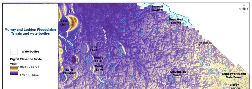
Figure 1. Planning framework for decisions about environmental water management in Victoria.
   1.1. Purpose and scope
The McDonalds Swamp EWMP is a ten year management plan that describes the ecological values
present, the long-term goal for the wetland and priority ecological objectives and the required
watering regime to achieve these objectives. It is based on both scientific information and
stakeholder consultation and will be used by the North Central CMA when making annual
environmental watering decisions, as well as Department of Environment, Land, Water, and Planning
(DELWP) and the Victorian Environmental Water Holder (VEWH) for both short and longer-term
environmental water planning (Department of Environement and Primary Industries [DEPI] 2014a).
The key purposes of the EWMP are to:
   •   identify the long-term objectives and water requirements for the wetland;

McDonald Swamp Environmental Water Management Plan                                                  9
• provide a vehicle for community consultation, including for the long-term objectives and
water requirements of the wetland;
• inform the development of future SWPs and seasonal watering plans; and
• inform Long-term Watering Plans that will be developed by the State under the Basin Plan
Chapter 8 (DEPI 2014a).
The scope of this EWMP is the western section of McDonalds Swamp currently managed by Parks
Victoria as a State Wildlife Reserve. This area accounts for approximately 76 percent of the total area
of the wetland. The remaining 24 percent, which runs along the eastern boundary of the Piccaninny-
Barr Drain, is part of the Wildlife Reserve, but does not currently receive environmental water.
1.2. Development Process
McDonalds Swamp has an Environmental Watering Plan that was prepared by the North Central
CMA under the Goulburn Murray Water Connections Project (formerly the Northern Victoria
Irrigation Renewal Project). The development of the EWP was to establish a volume of mitigation
water that Goulburn Murray Water Connections Project was required to set aside for Lake Murphy.
The development process for the EWP established ecological objectives and a watering regime for
McDonalds Swamp. The McDonalds Swamp EWMP is based on work undertaken for, and presented
in, the McDonalds Swamp Environmental Watering Plan 2010 (EWP), and was developed in
collaboration with key stakeholders including DELWP, Parks Victoria, VEWH and Goulburn Murray
Water (GMW). A number of tasks were undertaken to develop the EWMP including:
• Scoping and collating information: to understand the topography, current condition and
threats to McDonalds Swamp the following surveys were undertaken at the onset of the
EWMP project:
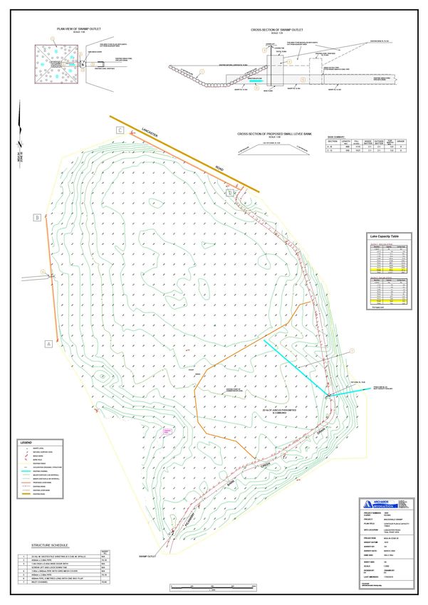
o Bathymetric survey and capacity table; a bathymetric survey and associated ratings
table for McDonalds Swamp area (including north of Lawrys Road) was produced in
August 2014
o Vegetation survey, mapping and analysis; baseline flora and fauna surveys including
Ecological Vegetation Condition (EVC) mapping, IWC assessments and flora and fauna
(incidental) surveys were undertaken in August 2014.
o Hydrogeological assessment: a surface and groundwater assessment was undertaken
in January-February 2015.
o Expert workshop: a scientific team was engaged to provide technical review on the
draft ecological and hydrological objectives.
o Community and stakeholder consultation: The original community and stakeholder
group was reconvened to provide input into the draft EWMP, particularly relating to
the water management goal, ecological objectives and optimum watering regime. See
Appendix 6 for further details.
The conversion of the McDonalds Swamp EWP to EWMP has been undertaken in collaboration with
key stakeholders including DELWP, Parks Victoria, VEWH, GMW and local landholders. The most
recent technical information including monitoring data, water delivery information and results of
ecological investigations has been considered in the development of the McDonalds EWMP.
Information from the above tasks was analysed to provide justification and evidence for the
following sections of the EWMP:
o Water dependent values: environmental values were derived from the baseline flora
and fauna surveys, historical reports, DELWP databases and community and
stakeholder accounts. Terrestrial species that, due to large-scale clearing of woodland
McDonald Swamp Environmental Water Management Plan 10habitat throughout the catchment, are dependent on the vegetation surrounding the
wetlands are also documented. Social values (cultural heritage, recreation and
economic) are further described.
o Ecological condition, condition trajectory and threats: Available information,
including IWC assessments, were used to describe the current condition and water
related threats to McDonald Swamp. A “do-nothing” scenario is further considered to
understand the condition trajectory if no action is undertaken.
o Management objectives: The water management goal and the ecological objectives
for McDonalds Swamp are based on the water dependent values recorded for the
wetland, the current condition and the condition trajectory. The objectives are also
aligned with the broader environmental outcomes proposed in the Basin Plan draft
Environmental Watering Strategy 2014.
o Managing risks: the risks to achieving the ecological objectives for McDonald Swamp
are based on the best-available scientific and local knowledge. Management actions
to mitigate each risk have been recommended and residual risk (assuming full
adoption of management action) identified.
o Environmental water delivery infrastructure: Current constraints to delivery of
environmental water are identified as well as recommendations to allow future
environmental water delivery.
o Demonstrating outcomes: monitoring to adaptively manage the delivery of
environmental water and to demonstrate the outcomes against the ecological
objectives are based on best available science monitoring method. Justification for a
suite of long term and intervention monitoring recommendations are given.
o Knowledge gaps and recommendations: a number of knowledge gaps were identified
during the process of developing the ecological objectives, management actions and
risk analysis sections. A series of recommended activities as well as a priority ranking
is given for each knowledge gap.
McDonald Swamp Environmental Water Management Plan 112. Site overview
2.1. Site location
McDonalds Swamp is located approximately thirteen kilometres east of Kerang and ten kilometres
west of the Murray River (Figure 2). The Piccaninny-Barr Drain transects the wetland, separating it
into McDonalds Swamp East and McDonalds Swamp West (Appendix 2). Only McDonalds Swamp
West currently has the appropriate infrastructure for delivery of environmental water.
Figure 2. Location of McDonalds Swamp
2.2. Catchment setting
Climate
Climate data were obtained from the Bureau of Meteorology (BOM) for the Kerang meteorological
station. Rainfall in the Kerang region averages 377 mm/year, with May to October being significantly
wetter than November to April (Macumber 2002). Maximum average temperatures range from
31.6°C in January to 14.1°C in July, with minimum temperatures rarely below zero (BOM 2015).
Evaporation rates from the ‘Kerang Model Farm’ shows pan evaporation (Class A Pan) rates of
approximately 1,384.1 mm ranging from 32.8 mm in June to up to 233.3 mm in January between
1991 and 2013 (data supplied by R & E Jones, 2013). Since there is only at most 80mm available for
evaporation at McDonalds Swamp, this means the wetland dries relatively quickly (SKM 2001).
Hydro-physical characteristics
McDonalds Swamp is located in the Barr Creek sub-catchment on the floodplains of the Loddon and
Murray rivers. It is situated within the Murray Fans bioregion, an area that is characterised by a flat
to gently undulating landscape on recent unconsolidated sediments, with evidence of former
braided stream channels and river meanders, and broad floodplain areas (DEPI 2014d). These
ancient rivers and streams deposited alluvial sediments that have resulted in a thick layer of mixed
McDonald Swamp Environmental Water Management Plan 12clay and sand, known as the Shepparton Formation, which can extend up to 40 metres below the
surface and overlies Parilla Sand and Renmark Group sediments (SKM 2001). The local catchment
area is low-lying and prone to flooding, resulting in surface sediments that are rich in clay and of low
permeability. Flood events and surface water movement, rather than groundwater, generally
dominate wetlands formed in this area (SKM 2001).
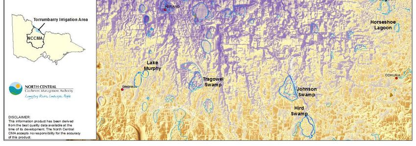
McDonalds Swamp forms part of the broader ‘Central Murray Wetland’ complex that occurs within
the Loddon-Murray region, and includes the Kerang Wetlands Ramsar site (although McDonalds is
unlisted). These wetlands include freshwater lagoons, permanent open freshwater lakes, deep
freshwater marches, saline and hypersaline wetlands (DSE 2004). Figure 3 shows the natural
topography of the area and the location of McDonalds Swamp within the broader wetland complex
of the area.
Figure 3. Terrain of the Murray and Loddon River Floodplains
2.3. Land status and management
Land use
Land use around the wetland has changed over time. Once surrounded by dairy farms, adjacent land
use now consists primarily of broadacre dryland agriculture (O’Brien, R, 2009, personal
communication [DPI], 19 November) and some annual and perennial pasture (SKM 2001, Campbell
et al. 2009). Nearby land is salt-affected (Bartley Consulting 2009), and there is a greater possibility
that this will negatively impact the wetland through pasture irrigation practices, rather than flooding
of the wetland impacting on surrounding land (SKM 2001). McDonalds Swamp is located within the
Torrumbarry Irrigation Area.
McDonald Swamp Environmental Water Management Plan 13Land tenure
McDonalds Swamp occupies approximately 164 ha of a 215 ha Crown land reserve (Archards
Irrigation 2010). The wetland is listed as a State Wildlife Reserve under the Crown Land (Reserves)
Act 1978 and is managed by Parks Victoria under the Wildlife Act 1975.
In 2009, the Victorian government endorsed (with amendments) the Victorian Environment
Assessment Council (VEAC) recommendations for public land management. McDonalds Swamp
remains as a wildlife reserve under the ‘state game reserve’ classification. Wildlife reserves are
managed to conserve and protect species, communities or habitats of indigenous animals and plants
while permitting recreational (including hunting in season as specified by the land manager) and
educational use (VEAC 2008; DSE 2009c).
There are several agencies directly involved in environmental water management in Victoria. Other
agencies, such as public land managers, play an important role in facilitating the delivery of
environmental watering outcomes. Table 1 describes the key stakeholders that have involvement in
the management of McDonalds Swamp.
Complementary works to environmental watering have been undertaken by the North Central CMA
at McDonalds Swamp, including revegetation works around the wetland fringe, weed control and
rabbit and fox control.
Table 1. Roles and responsibilities for environmental water in McDonalds Swamp
Agency/group Responsibilities/involvement
Department of - Manage the water allocation and entitlements framework
Environment, Land, - Develop state policy on water resource management and waterway management
Water and Planning approved by the Minister for Environment, Climate Change and Water
(DELWP) - Develop state policy for the management of environmental water in regulated and
unregulated systems
- Act on behalf of the Minister for Environment, Climate Change and Water to maintain
oversight of the VEWH and waterway managers (in their role as environmental water
managers)
- Legislative responsibilities for the management of flora and fauna
- Provides approval of EWMPs and endorsement of SWPs.
Victorian - Make decisions about the most effective use of the Water Holdings, including use, trade
Environmental and carryover
Water - Authorise waterway managers to implement watering decisions
Holder(VEWH) - Liaise with other water holders to ensure coordinated use of all sources of environmental
water
- Publicly communicate environmental watering decisions and outcomes
- Author of the Statewide Seasonal Watering Plan
- Provides final endorsement of SWPs
- Approves delivery of environmental water (Seasonal Watering Statement) and funds
environmental water related monitoring.
Commonwealth - Make decisions about the use of Commonwealth water holdings, including providing
Environmental water to the VEWH for use in Victoria.
Water Holder - Liaise with the VEWH to ensure coordinated use of environmental water in Victoria
(CEWH) - Report on management of Commonwealth water holdings.
McDonald Swamp Environmental Water Management Plan 14Agency/group Responsibilities/involvement
Murray-Darling - Implementation of the Murray-Darling Basin Plan - the Basin Plan sets legal limits on the
Basin Authority amount of surface water and groundwater that can be taken from the Basin from 1 July
(MDBA) 2019 onwards
- Integration of Basin wide water resource management
- Manager of The Living Murray water entitlements
North Central - Waterway Manager
Catchment - Identify regional priorities for environmental water management in regional waterway
Authority (North strategies
Central CMA) - In consultation with the community assess water regime requirements of priority rivers
and wetlands to identify environmental watering needs to meet agreed objectives identify
opportunities for, and implement, environmental works to use environmental water more
efficiently
- Propose annual environmental watering actions to the VEWH and implement the VEWH
environmental watering decisions
- Provide critical input to management of other types of environmental water (passing
flows management, above cap water) report on environmental water management
activities undertaken.
Goulburn Murray - Water Corporation – Storage Manager and Resource Manager
Water (GMW) - Work with the VEWH and waterway managers in planning for the delivery of
environmental water to maximise environmental outcomes
- Operate water supply infrastructure such as dams and irrigation distribution systems to
deliver environmental water
- Ensure the provision of passing flows and compliance with management of diversion limits
in unregulated and groundwater systems
- Provides endorsement of SWP and facilitates on-ground delivery.
Parks Victoria - Land Manager
- Implement the relevant components of EWMPs.
- Operate, maintain and replace, as agreed, the infrastructure required for delivery of
environmental water, where the infrastructure is not part of the GMW irrigation delivery
system.
- Where agreed, participate in the periodic review of relevant EWMPs and provides
endorsement of SWPs
- Manage and report on other relevant catchment management and risk management
actions required due to the implementation of environmental water.
Input, advice and interest in environmental watering
Barapa Barapa Nation - Traditional owners of the area encompassing McDonalds Swamp.
Aboriginal - The delivery of environmental water is likely to provide other benefits that depend on the
Corporation
condition of our waterways, such as supporting social and cultural values.
- Stakeholder and community groups developed to provide advice on the best use of
Central Murray environmental water in the Central Murray Wetland Complex, including McDonalds
Wetlands Swamp
Environmental Water
Advisory Group - Members are represented by GMW, DELWP, Parks Victoria, VEWH, North Central CMA,
(EWAG) Gannawarra Shire Council, Swan Hill Shire Council, Campaspe Shire Council, Birdlife
Australia, Field and Game Australia, and local community.
McDonald Swamp Environmental Water Management Plan 152.4. Wetland characteristics Victoria's wetland classification and inventory was updated in 2013 and replaces the system developed by Corrick and Norman. The updated classification is based on the Australian National Aquatic Ecosystem (ANAE) Classification Framework (the Framework) with data on wetlands and their classification attributes converted into spatial Geographic Information System (GIS) layers. The Framework structure produces 37 wetland types. Categories were adopted to distinguish naturally-occurring from human-made wetlands in the first level of the classification hierarchy. Aquatic ecosystem habitats: palustrine, lacustrine and estuarine distinguish wetlands in the second level of the classification hierarchy and wetland attributes: water regime, salinity, landscape context, soils and wetland vegetation distinguish wetlands in the third level of the hierarchy (DEPI 2014b). Under Corrick and Norman, the pre-European classification (1750 Classification) for McDonalds Swamp identified it as a shallow freshwater marsh. Due to extensive irrigation outfalls throughout the 20th century, it was re-classified as a deep freshwater marsh (1994 Classification). Based on the new classification system, McDonalds Swamp is a naturally occurring temporary freshwater marsh1 (DEPI 2014b). An overview of the wetland characteristics is provided in Table 2. 1 Under the 2013 Victorian wetland classification layer, the wetland type for McDonalds Swamp is ‘unknown’. However, based on the criteria for each wetland type, McDonalds Swamp has been classified by the North Central CMA as a temporary freshwater marsh. McDonald Swamp Environmental Water Management Plan 16
Table 2. Wetland characteristics of McDonalds Swamp
Characteristics                                 Description
Name                                            McDonalds Swamp
Mapping ID (Corrick)                            7726 344450
                                                Reserve                              215 hectares
Area (ha)                                       Wetland (McDonalds Swamp
                                                                                        164 hectares
                                                West)
Bioregion                                       Murray Fans
Conservation status                             Regionally significant wetland
Land status                                     Wildlife Reserve (126 ha), under the Wildlife Act 1975
Land manager                                    Parks Victoria
Surrounding land use                            Broadacre dryland agriculture
                                                     •     Historical: Piccaninny Creek
                                                     •     Current: Torrumbarry Irrigation System Channel Outfall (2/3)
Water supply                                         •     300 EC
                                                     •     Capacity of 30 ML/day
                                                     •     Average delivery rate 21 ML/day (approx. 42 days to FSL)
1788 wetland category (Corrick and Norman)      Shallow freshwater marsh (
an annual basis. The use of this water in McDonalds Swamp is not guaranteed and is at the
discretion of the VEWH (VEWH 2012).
Commonwealth Water Holdings
Commonwealth water holdings are the direct result of government purchases of entitlements and a
substantial investment in more efficient water infrastructure in the Murray Darling Basin. As at 25
March 2015, the Commonwealth environmental water holdings totaled 3,397 ML for the Loddon
River system and 310,217 ML for the Murray River system. The use of this water for wetlands in the
North Central CMA region is not guaranteed and is at the discretion of the CEWH (CEWH 2015).
GMW Connections Project – Environmental Entitlement (Murray System)
The Goulburn-Murray Water Connections Project is an irrigation modernisation project developing
an improved water delivery network across northern Victoria. While improving irrigation efficiency,
the Connections Project will reduce outfall volumes to wetlands, including McDonalds Swamp.
‘Mitigation water’ will therefore be delivered to ensure there is no net impact on high
environmental values. Mitigation water is the volume of water required to offset the impact of the
Connections Project. Calculation of mitigation water is detailed in the McDonalds Swamp
Environmental Watering Plan 2010.
Table 3. Environmental water sources for McDonalds Swamp
Water entitlement Volume Flexibility of Conditions on Responsible
management availability and use agency
28,750 ML (high
reliability)
Can be used across
3,893 ML (low Fully flexible
multiple systems, within VEWH
Bulk Entitlement (River reliability) management
relevant trade protocols
Murray – Flora and Carryover
Fauna) Conservation determined by VEWH
Order 1999 Flexible Only available for use
40,000 ML management in during declared periods of
VEWH
(unregulated flows) declared periods unregulated flows on the
only Murray system
Environmental Can only be used in wetlands that have an
Entitlement (Murray 136 ML for approved Environmental Watering Plan with
VEWH
System - NVIRP Stage McDonalds Swamp mitigation water recommended, such as
1) 2012 McDonalds Swamp.
Agreement is Can be used across
Commonwealth Water CEWH (facilitated
Determined by CEWH required with the multiple systems, within
Holdings through VEWH)
CEWH relevant trade protocols
2.6. Related agreements, legislation, policy, plans and activities
There are a range of international treaties, conventions and initiatives, as well as National and
Victorian State Acts, policies and strategies that direct management of wetlands within Victoria.
Those that may have particular relevance to the management of the environmental and cultural
values at McDonalds Swamp are listed below. The function and major elements of each can be
sourced from Appendix 1.
International treaties, conventions and initiatives:
• Japan Australia Migratory Birds Agreement (JAMBA) 1974 - 7 of the species listed under this
agreement have been recorded at McDonalds Swamp.
• China Australia Migratory Birds Agreement (CAMBA) 1986 - 8 of the species listed under this
agreement have been recorded at McDonalds Swamp.
McDonald Swamp Environmental Water Management Plan 18• Republic of Korea Australia Migratory Birds Agreement (ROKAMBA) 2002 - 5 of the species
listed under this agreement have been recorded at McDonalds Swamp.
• Convention on the Conservation of Migratory Species of Wild Animals (Bonn Convention)
1979 – 6 of the species listed under this convention have been recorded at McDonalds
Swamp.
Commonwealth legislation and policy:
• Aboriginal and Torres Strait Islander Heritage Protection Act 1984 (Part IIA) – McDonalds
Swamp is an area of cultural sensitivity.
• Environment Protection and Biodiversity Conservation Act 1999 (EPBC Act) - 1 migratory
species listed under this Act have been recorded at McDonalds Swamp.
• Water Act 2007 – to provide for the protection of ecological values at McDonalds Swamp
through appropriate management of Murray-Darling Basin water resources.
Victorian legislation:
• Aboriginal Heritage Act 2006 – McDonalds Swamp is an area of cultural sensitivity.
• Catchment and Land Protection Act 1994 - governs the management of land surrounding
McDonalds Swamp e.g. pest plant and animal control.
• Water Act 1989 - provides a formal means for the integrated management of water in
Victoria.
• Wildlife Act 1975 - Parks Victoria manages McDonalds Swamp in accordance with this Act.
• Flora and Fauna Guarantee Act 1988 (FFG Act) - 10 fauna species and 2 flora species listed
under this Act have been recorded at McDonalds Swamp.
National policies and strategies:
• The National Cultural Flows Research Project – this project is investigating indigenous water
values and uses to form the basis for cultural flow water entitlements. These would be
legally and beneficially owned by the Indigenous Nations and are of a sufficient and
adequate quantity and quality to improve the spiritual, cultural, environmental, social and
economic conditions of those Indigenous Nations. The cultural flows framework is under
development but may influence McDonalds Swamp as it is an area of cultural sensitivity.
Victorian policy and strategies:
• Victorian threatened flora and fauna species (DEPI advisory lists) – 24 fauna species and 8
flora species on the DEPI advisory lists have been recorded at McDonalds Swamp.
• Victorian Waterway Management Strategy (VWMS) – this strategy outlines the direction for
the Victorian Government’s investment over an eight year period (beginning in 2012-13).
The overarching management objective is to maintain or improve the environmental
condition of waterways to support environmental, social, cultural and economic values (DEPI
2013a).
Regional strategies and plans:
• North Central Regional Catchment Strategy (RSC) (North Central CMA 2012) – this strategy
(2013-2019) sets regional priorities for the management of natural assets, and sets overall
direction for investment and coordination of effort by landholders, partner organisations
and the wider community. The Central Murray Wetlands Complex is identified as a key
priority wetland asset in the RCS that supports highly depleted wetland types and significant
threatened flora and fauna speices.
McDonald Swamp Environmental Water Management Plan 19• North Central Waterway Strategy ( NCWS) (North Central CMA 2014) – this regional strategy
is an action out of the Victorian Waterway Management Strategy and provides the
framework for managing rivers and wetlands with the community over the next eight years.
It delivers key elements of the VWMS including developing work programs to maintain or
improve the environmental condition of waterways in the north central region. McDonalds
Swamp is a priority wetland for this eight year planning period.
McDonald Swamp Environmental Water Management Plan 203. Hydrology and system operations
Wetland hydrology is the most important determinant in the establishment and maintenance of
wetland types and processes. It affects the chemical and physical aspects of the wetland which in
turn affects the types of flora and fauna that the wetland supports. A wetland’s hydrology is
determined by surface and groundwater inflows and outflows in addition to precipitation and
evapotranspiration (Mitsch & Gosselink 2000). Duration, frequency and seasonality (timing) are the
main components of the hydrological regime for wetlands and rivers.
3.1. Wetland hydrology, water management and delivery
3.1.1. Pre-regulation
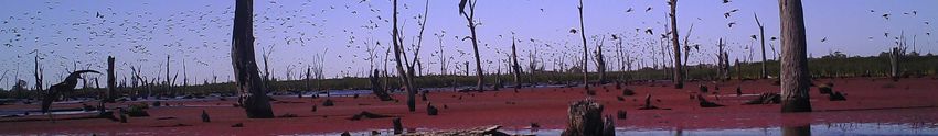
The geology of the area indicates that prior to European settlement McDonalds Swamp would have
been part of a larger wetland in association with the adjacent Red Gum Swamp, shown in Figure 4
(Bartley Consulting 2009). The wetland functioned as an intermittent shallow marsh wetland that
would have experienced periodic flooding during moderate to large flood events in the River Murray
(Hall, G, 2010, personal communication, [previous NCCMA flood manager], 25 January). Water
flowing into Gunbower Creek from the River Murray would have subsequently travelled northwest
via the Picaninny Creek, a 27km tributary of Barr Creek. Flood water would first inundate Red Gum
Swamp, and then flow approximately 500m south-east via the creek into McDonalds Swamp before
re-connecting to Barr Creek.
Based on the ecological and hydrological characteristics of the wetland and Picaninny Creek, it is
likely that McDonalds Swamp received inflows up to seven years in ten during winter and spring, and
drawing down by the following autumn mainly through evaporation (Australian Ecosystems 2012).
The wetland supported a River Red Gum (Eucalyptus camaldulensis) vegetation community that
would tolerate intermittent flooding.
Figure 4. McDonalds Swamp in the landscape
McDonald Swamp Environmental Water Management Plan 213.1.2. Post-regulation
The establishment of the Torrumbarry Irrigation System in the 1920s, construction of levees across
the floodplain and the dredging of the Piccaninny Creek in the 1960s have resulted in significant
changes to the hydrology of McDonalds Swamp. The wetland is now disconnected from its natural
flow path, rarely receiving water from the Piccaninny Creek, which has been deepened to become a
drain (Bartley Consulting 2009). Since the dredging, the water level in the Picaninny Drain is rarely
high enough to flow into the wetland (Hydro Environmental 2009).
With the advent of irrigation in the area, McDonalds Swamp was connected to the Torrumbarry
Irrigation System and has historically received the following sources of water:
• channel outfalls during and at the end of irrigation season via channel 2/3, sometimes in
excess of 40% of the wetland’s capacity in any one year;
• rainfall rejection flows;
• irrigation drainage flows from adjacent land; and
• run-off from a small area to the west of McDonalds Swamp (~100ha) that constitutes the
wetland’s local catchment area and is drained by a small drain (channel 8/1/1 that off-takes
from channel 5/5 at Craig Road).
The combination of these inflows represented a departure from the wetland’s natural watering
regime, resulting in almost permanent inundation (SKM 2001).
Due to increased efficiencies in irrigation infrastructure and practices, the volume of channel outfalls
decreased throughout the 1990s and early 2000s. The wetland’s hydrology shifted again from an
almost permanent watering regime to an annual wetting/drying regime, with the wetland drying out
completely in 2006-07 and 2008-09 during the drought (North Central CMA 2010). In response to the
decreased availability of water, environmental water was delivered intermittently to the wetland
from 1998 onwards. Table 4 demonstrates the watering history of McDonalds Swamp over the last
twenty years.
Table 4. McDonalds Swamp wetting/drying calendar (Source: Seasonal Watering Proposal for the
Central Murray Wetland Complex 2015-16)
Season
Recommended
watering Watering History 1995 1996 1997 1998 1999 2000 2001 2002 2003 2004
regime - - - - - – - - - -
1996 1997 1998 1999 2000 2001 2002 2003 2004 2005
1
Status W W D W W W W W W W
2
Water source U U - E/C C E/C E/C E/C E/C E/C
One event
every year (i.e. 2005 2006 2007 2008 2009 2010 2011 2012 2013 2014
wet and dry - - - - - - - - - -
cycle every 2006 2007 2008 2009 2010 2011 2012 2013 2014 2015
year) (duration
of ~8mths) 1 D-W- D-W-
Status W-D D D W W W W-D W
D D
2
Water source - - - E E E/F/I - E E E
1
Water present / dry wetland
2
Environmental water allocation / Flood mitigation / Unknown / Channel outfall / Surplus flows / Flood Inundation/Irrigation Tailwater
As a consequence of regulation in the local area, surface water connectivity between McDonalds
Swamp and Red Gum Swamp, Picaninny and Barr Creek has been reduced. An outlet structure to the
McDonald Swamp Environmental Water Management Plan 22south of McDonalds Swamp could allow for some drainage or throughflow into the Picaninny Creek
which runs a short distance before connecting to Barr Creek (Figure 8).
3.1.3. Groundwater/surface water interactions
As McDonalds Swamp would naturally have been intermittently filled and flushed by floodwaters it
would have been a temporary source of groundwater recharge once the local groundwater levels
receded following flood events. Groundwater levels are estimated to have been 10 to 20 metres
below the surface prior to European settlement, and had less influence on the flooding regime of the
wetland (SKM 2001). However, following development of the irrigation system, groundwater levels
within the Kerang region rose dramatically to within 80 cm of the surface in some areas (Bartley
Consulting 2009, SKM 2001).
Groundwater monitoring at McDonalds Swamp is conducted by DELWP and local volunteers. DELWP
collect groundwater data from regional bores in the State Observation Bore Network whilst data is
collected from other bores within the vicinity by both DELWP and volunteers. Only one bore (6613)
has long-term data available. Figure 5 shows the locations of groundwater bores in the vicinity of
McDonalds Swamp.
Figure 5. Groundwater bores in the vicinity of McDonalds Swamp
McDonald Swamp Environmental Water Management Plan 23You can also read