North West river basin district Flood Risk Management Plan 2015 to 2021 - PART A - Background and river basin district wide information - Gov.uk
←
→
Page content transcription
If your browser does not render page correctly, please read the page content below
North West river basin district
Flood Risk Management Plan 2015 to
2021
PART A – Background and river basin
district wide information

March 2016

                                      1 of 97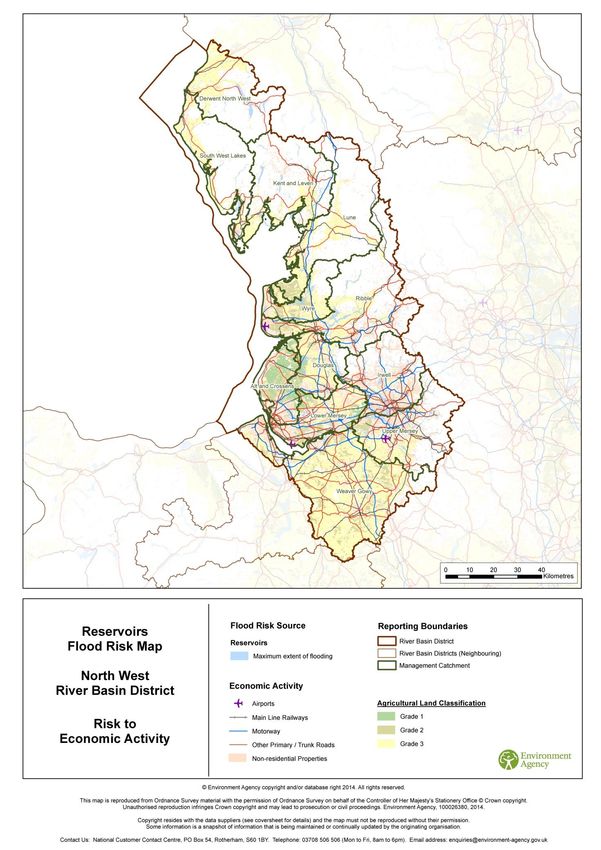
Published by:
Environment Agency                           Further copies of this report are available
Horizon house, Deanery Road,                 from our publications catalogue:
Bristol BS1 5AH                              www.gov.uk/government/publications
Email: enquiries@environment-agency.gov.uk
                                             or our National Customer Contact Centre:
www.gov.uk/environment-agency
                                             T: 03708 506506
                                             Email: enquiries@environment-agency.gov.uk.
© Environment Agency 2016
All rights reserved. This document may be
reproduced with prior permission of the
Environment Agency.

                                                                                           2 of 97
North West River Basin District
Flood Risk Management Plan
December 2015

Phase 1 of The River Mersey Flood Risk Management scheme, Warrington. Phase 1 protects 1,500 properties.

                                                                                                           3 of 97
This is a joint plan prepared by the following Risk Management
Authorities:

                                                                 4 of 97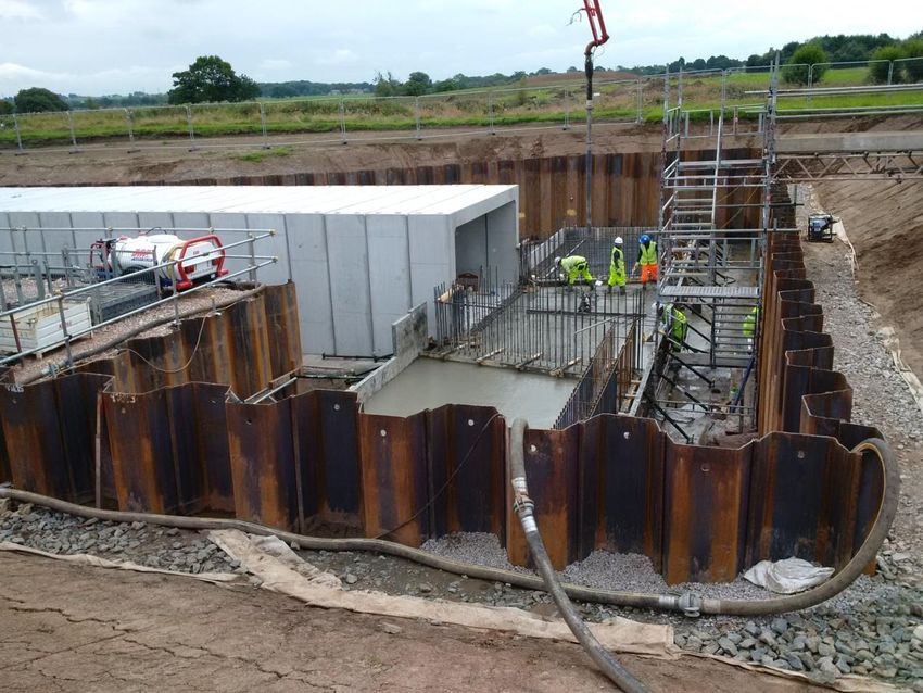
Foreword
The 2013/14 and 2015/16 winter storms and flooding had significant impacts on some
communities, businesses, infrastructure, rural areas and the environment. Evidence suggests
there could be more extremes in the weather with a changing climate leading to more frequent and
more severe flooding. During December 2015, Storms Desmond, Eva and Frank brought record
breaking rainfall levels and significant flooding to some parts of the UK. Over 19,000 homes and
businesses were flooded, with thousands more affected by loss of power supply and travel
disruption. Existing flood defences played an essential part in protecting thousands of homes
during December with 12,500 benefitting during Storm Desmond and 10,900 during Storm Eva.
Support is in place for affected communities, business and the agricultural sector, along with a
programme of inspections and repairs to damaged defences. These December 2015 flood events
have emphasised the need to be sure we have the very best possible plans in place for flood
management across the whole country.
Risk Management Authorities (RMAs) are committed to producing Flood Risk Management Plans
(FRMPs) required by the EU Floods Directive. This FRMP is an important part of meeting that
objective and aligns with the Defra Strategy and guiding principles of the National Flood and
Coastal Erosion Risk Management Strategy.
The FRMP will provide the evidence to support decision making. The FRMP will also help promote
a greater awareness and understanding of the risks of flooding, particularly in those communities
at high risk, and encourage and enable householders, businesses and communities to take action
to manage the risks. The highest priority is to reduce risk to life.
Measures (actions) in individual FRMPs do not all have secured funding and are not guaranteed to
be implemented. Money is allocated to all RMA measures in the same way, based on current
Government policy that gives the highest priority to lives and homes.
This FRMP brings together for the first time measures to address all sources of flooding in the
North West. It is based on the most up-to-date information available at the point of publication.
Measures in the FRMP are the starting point for RMA decision making and delivery. As part of on-
going strategic planning additional measures will be included in RMAs and other partners work
programmes between 2015 - 2021, although the FRMP will not be updated. FCRM strategic
planning is a continuous process and informs RMA decision making and will be the basis for the
2nd cycle FRMPs.
This document has been produced in consultation with professional partners. The Flood Risk
Management Plan (FRMP) sets out the proposed measures to manage flood risk in the North West
River Basin District from 2015 to 2021. This plan should be read in conjunction with the following:
Lead Local Flood Authority Local Strategies listed in Annex 1
In England, RMAs include the Environment Agency, Lead Local Flood Authorities (LLFAs), district
councils (where there are no unitary authorities), internal drainage boards, water companies and
highway authorities. These RMAs work in partnership with communities to reduce the risk of
flooding. The Environment Agency would like to thank the organisations listed on the previous
pages for their contributions and feedback during consultation.
Flood risk in England will continue to change as a result of a growing population and a changing
climate. There are many ways to manage flood risk including maintaining and building new flood
defences, building flood resilient homes and working more closely with nature to restore flood
plains. Flood risk management planning is not new and RMAs have been able to draw on the
experience of partners and earlier plans.
Following the December 2015 floods, Defra announced a National Flood Resilience Review, to
assess how the country can be better protected from future flooding and increasingly extreme
weather events. The review is looking at climate modelling, infrastructure, resilience and future
investment strategy. Government is also working to strengthen or establish partnerships in the
areas most flood affected to encourage a more integrated approach to managing risk across the
5 of 97
whole catchment. These Partnerships are considering improvements to flood defences, upstream
options to help slow the flow and surface water runoff, and how planning and design of urban
areas can help reduce flood risk. They are also aiming to build stronger links between local
residents, community groups and flood management planning and decision making. The resulting
actions from the Local Flood Partnerships in Cumbria and Yorkshire will complement the measures
in the relevant FRMPs and the learning from this approach will be shared across the country. In
England, the Government is investing £2.3bn on 1,500 flood defence schemes between 2015-
2021. Investment in flood risk management infrastructure not only reduces the risks of flooding but
also supports growth by helping to create new jobs, bringing confidence to areas previously
affected by floods and creating and restoring habitats.

The FRMP also sets out how these proposed measures can contribute to improving the
environment and how they support the objectives of River Basin Management Plans (RBMPs) and
specifically the North West RBMP that the Environment Agency has produced in parallel with this
FRMP. Both flood risk management and river basin planning form an important part of a
collaborative and integrated approach to catchment planning for water. Building on this essential
work, and in the context of the Governments 25-year environment plan, we aim to move towards
more integrated planning for the environment over the next cycle. This will be done on a catchment
basis and will draw together and integrate objectives for flood risk management, water
management, and biodiversity, with the aim of maximising the multiple benefits that can be
achieved.

Steve Moore

Director of Operations, North and East

                                                                                            6 of 97
Contents
Glossary and abbreviations ............................................................................................................................... 9
The format of the flood risk management plan .......................................................................................... 11
The layout of this document ......................................................................................................................... 11
1      What is flood risk and who manages it? ............................................................................................. 13
What is the likelihood of this happening and what does this mean? ............................................................... 13
Roles and Responsibilities............................................................................................................................... 14
Existing flood management schemes and properties protected...................................................................... 16
Flood Risk Information ..................................................................................................................................... 16
Flooding from rivers and the sea ..................................................................................................................... 16
Flooding from reservoirs .................................................................................................................................. 17
Flooding from surface water ............................................................................................................................ 17
2      What is a Flood Risk Management Plan? ............................................................................................ 18
What is the flood risk management plan for? .................................................................................................. 18
Why are flood risk management plans being prepared? ................................................................................. 18
What the plan does .......................................................................................................................................... 18
What types of flood risk are included in the flood risk management plans? ................................................... 20
3      How the plan has been developed ....................................................................................................... 23
The approach to developing flood risk management plans ............................................................................. 23
Consultation and engagement ......................................................................................................................... 24
Objective setting .............................................................................................................................................. 24
Six year investment programme ...................................................................................................................... 24
Long term investment scenarios ...................................................................................................................... 25
Flood and coastal risk management and agriculture ....................................................................................... 25
Strategic Environmental Assessment and Habitats Regulations .................................................................... 25
How flood risk management plans have been co-ordinated with river basin management planning (RBMP) 26
4      How to manage risk ............................................................................................................................... 27
National flood and coastal erosion risk management strategy for England .................................................... 27
Measures for managing risk ............................................................................................................................ 28
Flood risk management activities .................................................................................................................... 29
Working with Communities .............................................................................................................................. 31
Partnership Working ........................................................................................................................................ 31
Catchment based approach ............................................................................................................................ 33
Internal Drainage Boards ................................................................................................................................. 34
5      Getting to know the North West river basin district .......................................................................... 35
Introduction ...................................................................................................................................................... 35
Water ............................................................................................................................................................... 35
Flood risk management systems and drainage ............................................................................................... 35
Climate and climate change adaptation .......................................................................................................... 38
Coastal erosion risk management ................................................................................................................... 39
Society and health ........................................................................................................................................... 40
Land use .......................................................................................................................................................... 41
                                                                                                                                                            7 of 97
Economic activity ............................................................................................................................................. 42
Recreation and tourism.................................................................................................................................... 42
Infrastructure .................................................................................................................................................... 43
Landscape ....................................................................................................................................................... 44
Biodiversity ...................................................................................................................................................... 45
Cultural heritage .............................................................................................................................................. 45
Geology............................................................................................................................................................ 45
Soil ................................................................................................................................................................... 46
6      Key Flood Risk Issues in the North West river basin district ........................................................... 47
Flood History .................................................................................................................................................... 48
Flood risk from rivers and the sea ................................................................................................................... 53
Flood risk from reservoirs ................................................................................................................................ 60
Flood risk from surface water .......................................................................................................................... 64
Flood risk from groundwater ............................................................................................................................ 71
Flood risk from canals...................................................................................................................................... 71
Flood risk from sewers ..................................................................................................................................... 72
7      Sub-areas in the North West river basin district ................................................................................ 75
Introduction ...................................................................................................................................................... 75
Flood Risk Areas ............................................................................................................................................. 76
Management Catchments................................................................................................................................ 76
8      Conclusions, objectives and measures to manage risk for the North West river basin district ... 77
Conclusions ..................................................................................................................................................... 77
Objectives to manage risk for the North West river basin district .................................................................... 81
Measures across the North West river basin district ....................................................................................... 82
Flood Risk Management Plan contributing to broader benefits ...................................................................... 87
9      Implementing the plan ........................................................................................................................... 96
The Catchment based approach ..................................................................................................................... 96
Monitoring delivery of measures ...................................................................................................................... 96

                                                                                                                                                               8 of 97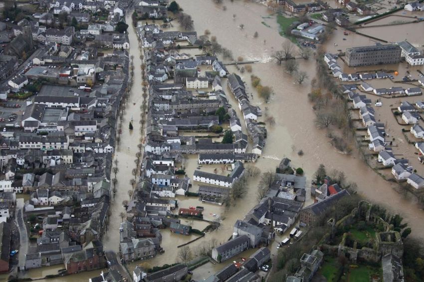
Glossary and abbreviations
AONB               Area of Outstanding Natural Beauty
BAP                Biodiversity Action Plan
Catchment          The watershed of a surface water river system
CaBA               Catchment based approach: an approach to environmental planning that
                   focuses on local engagement and partnerships
CFMP               Catchment Flood Management Plan
Coastal Groups     Voluntary coastal defence groups made up of maritime district authorities and
                   other bodies with coastal defence responsibilities.
Cross Border       Set up under The Flood Risk (Cross Border Areas) Regulations 2012 (SI No.
Advisory Group     1102). A statutory group made up of representatives from SEPA, Environment
(CBAG)             Agency and local authorities within the cross border areas.
Cross Border       Those areas designated as ‘cross border’ under The Flood Risk (Cross Border
Areas              Areas) Regulations 2012 (SI No. 1102).
CWS                County Wildlife Site
DCLG               Department for Communities and Local Government
Defra              Department for Environment, Food and Rural Affairs
EA                 Environment Agency
EIA                Environmental Impact Assessment
EPR                Environmental Protection Regulations
EU                 European Union
FCERM              Flood and coastal erosion risk management
Floods Directive   The European Floods Directive (2007/60/EC) on the assessment and
                   management of flood risks.
Flood Risk Area    Areas where the risk of flooding from local flood risks is significant as
(FRA)              designated under the Flood Risk Regulations.
FRM                Flood Risk Management
FRMP               Flood Risk Management Plan – plan produced to deliver the requirements of
                   the Flood Risk Regulations.
Government         The term government is used within this report to refer to Defra (the
                   Department for Environment, Flood and Rural Affairs) and Welsh Government.
Groundwater        Occurs when water levels in the ground rise above the natural surface. Low-
flooding           lying areas underlain by permeable strata are particularly susceptible.
Ha                 Hectares
HLS                Higher Level (Environmental) Stewardship
HRA                Habitats Regulations Assessment: an assessment undertaken in relation to a
                   site designated under the Habitats and Birds Directives
Km                 Kilometres
LDF                Local Development Framework
LiDAR              Light Detection And Ranging
LLFA               Lead Local Flood Authority
Local FRM          Local flood risk management strategy produced by LLFAs under the Flood and
Strategy           Water Management Act 2010.

                                                                                                   9 of 97
Main river             A watercourse shown as such on the main river map, and for which the
                       Environment Agency and Natural Resources Wales has responsibilities and
                       powers
MSFW                   Making Space for Water
National FCERM         National flood and coastal erosion risk management strategy: these are
Strategy               strategies prepared under the Flood and Water Management Act 2010, by the
                       Environment Agency for England and by Welsh Government for Wales.
NNR                    National Nature Reserve
NRW                    Natural Resources Wales. The NRW took over the functions of the
                                                       st
                       Environment Agency in Wales on 1 April 2013.
Ordinary               All watercourses that are not designated Main River, and which are the
watercourses (OW)      responsibility of Local Authorities or, where they exist, Internal Drainage
                       Boards.
PFRA                   Preliminary Flood Risk Assessment – these were required to be published by
                       December 2011 and were the first stage in delivering the Regulations.
PU                     Policy Unit
Ramsar                 Wetlands of international importance designated under the Ramsar Convention
Reservoir              A natural or artificial lake where water is collected and stored until needed.
                       Reservoirs can be used for irrigation, recreation, providing water supply for
                       municipal needs, hydroelectric power or controlling water flow.
Risk management        Organisations that have a key role in flood and coastal erosion risk
authorities (RMAs)     management as defined by the Act. These are the Environment Agency,
                       Natural Resources Wales, lead local flood authorities, district councils where
                       there is no unitary authority, internal drainage boards, water companies, and
                       highways authorities.
RFCCs                  Regional Flood and Coastal Committees
River Basin District   These are the reporting units to the European Commission for the Water
                       Framework Directive and the Floods Directive.
RBMP                   River Basin Management Plan – plan required by the European Water
                       Framework Directive.
Riparian owner         Owner of land adjoining, above or with a watercourse running through it.
River flooding         Occurs when water levels in a channel overwhelms the capacity of the
                       channel.
SAC                    Special Area of Conservation
SAM                    Scheduled Ancient Monument
SAMP                   System Asset Management Plan
SEA                    Strategic Environmental Assessment
SFRA                   Strategic Flood Risk Assessment
SMP                    Shoreline Management Plan
SPA                    Special Protection Area
SSSI                   Site of Special Scientific Interest
SuDS                   Sustainable Drainage Systems
Surface water          Flooding from rainwater (including snow and other precipitation) which has not
flooding               entered a watercourse, drainage system or public sewer.
SWMP                   Surface Water Management Plan
UKCIP                  United Kingdom Climate Impact Projections

                                                                                                        10 of 97
The format of the flood risk
management plan
Flood Risk Management Plans have been divided into four sections to help readers identify and
access information relevant to them. This is Part A. The plan is divided into four parts:
Name Audience
Summary Document For those who a high level overview of the plan
Part A: Background and river basin For those who need some legislative background and
district wide information river basin district wide, high level information
Part B: Catchment Summaries For those who want the detail of the sub-areas and
flooding statistics. This section includes the catchments
based on Water Framework Directive (WFD)
management catchments, Flood Risk Areas (identified
through the Preliminary Flood Risk Assessment) and
other strategic areas across the river basin district.
Part C: Appendices For those who want to see the detailed program of work
for individual communities
Part A, Background and river basin district wide information - sets the scene for the FRMPs -
what they are, what they are for and how they have been developed. Part A goes on to describe
the river basin district at that scale.
The other parts of the flood risk management plan are located on gov.uk
(https://www.gov.uk/government/publications/north-west-river-basin-district-flood-risk-
management-plan )
The layout of this document
Section 1: what is flood risk and who manages it?
This explains what flood risk is, who is responsible for managing the risk and what their roles are.
Section 2: what is a flood risk management plan?
What a FRMP is, why it is being developed and describes the kind of information that is included in
the FRMP.
Section 3: how the plan has been developed
Describes how the Environment Agency, lead local flood authorities (LLFAs) and other risk
management authorities (RMAs) have prepared this FRMP.
11 of 97Section 4: how to manage risk
Section 4 describes some of the terminology used, such as ’conclusions’, ’objectives’ and
‘measures’, and how they relate to flood and coastal erosion risk management.
Section 5: Getting to know the river basin district
Section 5 of the plan introduces the North West river basin district and also introduces the ‘sub-
areas’ that divide the river basin district further.
Section 6: Key Flood risk issues in the river basin district
The flood and coastal erosion risks are set out for the river basin district in section 6.
Section 7: the sub-areas
Section 7 introduces each of the sub-areas in turn. This section outlines the catchments based on
Water Framework Directive (WFD) management catchments, which make up the river basin
district, then the FRAs (identified through the Preliminary Flood Risk Assessment) across the river
basin district.
Section 8: Conclusions, objectives and measures for the North
West river basin district
Section 8 sets out the risk conclusions, objectives and measures for the river basin district.
Section 9: implementing the plan, monitoring and reporting
Section 9 sets out the proposals for implementing the plan, including co-ordination with the
implementation of the RBMPs prepared under the WFD. Section 9 concludes with how the
measures will be monitored and reported.
Find out more
Throughout this document you will be directed via hyperlink to more detailed sources of
information using 'find out more’ boxes.
12 of 97PART A
1 What is flood risk and who
manages it?
The Flood and Water Management Act (2010) defines flooding as any case where land not
normally covered by water becomes covered by water. Flood risk is a combination of
two components: the chance (or probability/ likelihood) that a location will flood from any source or
type of flooding, and the impact (or consequence) that the flooding would cause if it occurred.
Flood risk management is generally concerned with reducing harm which might take the form of
property damage or physical injury to people and wildlife. However, flooding can also have
beneficial effects too, in particular for wetland wildlife as well as some types of agriculture that are
water dependent.
Risk Likelihood Impact
= x
Figure 1 What is flood risk?
Risk captures the severity of, or related consequences produced by, a flood event. Impacts can be
social, economic and environmental, for example the number of properties flooded and the level of
associated economic damages. The consequences of a flood depend on the level of exposure
and the vulnerability of those affected.
What is the likelihood of this happening and what does this mean?
Probability (or chance) is a measure of the likelihood that a defined event will occur. The
probability of a flood event is typically defined as the relative frequency of occurrence of that flood
being equalled or exceeded. Probability can be expressed as a fraction, percentage, a decimal or
description, and should always make reference to a time period. For example, the industry refers
to a 1 in 100 chance of flooding in any given year’ or a 1% annual probability of flooding’, which
both refer to the same likelihood.
Assessing impacts of flooding prior to an event usually involves estimating the potential impact of
flooding on people, property and the environment. The theoretical probability of flooding is
illustrated by the Environment Agency Flood Maps which show flood risk for rivers and the sea,
surface water and reservoirs. Flood models which are the basis for Environment Agency flood
maps use uniform rainfall scenario (the same amount of rainfall falling across the country),
whereas in reality rainfall rates vary greatly from one town to another.
It is not possible to prevent all flooding, but there are a variety of actions which can manage these
risks and their impacts on communities. Flood risk managers must identify all potential options to
manage flood risk and balance the needs of communities, the economy and the environment. Risk
management authorities (RMAs) should work in partnership with each other and communities to
manage flood risk, ensuring that communities are part of the decision making process and
understand and actively prepare for the risks. By working together risk management authorities
should actively seek opportunities to coordinate risk management, encourage partnership funding
and deliver multiple benefits.
13 of 97Roles and Responsibilities
Table 1 and 2 show the RMAs involved in flood risk management in England and their roles and
responsibilities.
The responsibilities for managing flooding in the UK is divided between different risk management
authorities (RMAs) as defined in the Flood and Water Management Act. RMAs have powers and
duties to manage the different forms for flooding that can occur as shown in table 1 (page 14). The
Environment Agency is responsible for taking a strategic overview of the management of all
sources of flooding and coastal erosion. Following the December 2015 floods Defra is looking at
how this strategic overview role can be strengthened at the catchment scale to promote a more
integrated approach to managing the water environment.
Table 1 Summary of responsibilities for risk management authorities
Lead Local Internal
Environment District Water Highways
Risk Source Flood Drainage
Agency Councils Company Authority
Authority Board
Main River
Sea flooding
Surface Water
Surface Water (on or
coming from the
Highway)
Sewer Flooding
Ordinary Watercourse
Groundwater
Reservoirs * * * * * *
Coastal Erosion
Strategic overview of all
sources of flood risk
(and the coast)
*Please note RMAs have different responsibilities for reservoirs such as regulation, asset
management and flood incident response
14 of 97Table 2 Roles and responsibilities of risk management authorities and others involved in
managing flood risk
Risk Management Role and responsibilities
Authorities and
others
Environment Agency The Environment Agency has a strategic overview of all sources of flooding and
coastal erosion (rivers, the sea, groundwater, reservoirs and surface water).
Permissive powers to manage flood risk from ‘main rivers’, the sea and
reservoirs. Can use enforcement powers to require landowners to take action to
minimise flood risk to others.
Lead Local Flood LLFA. A county council or unitary council. Permissive powers to manage flood
Authority risk from surface water, ‘ordinary watercourses’ (non-main rivers) outside of
internal drainage districts, and groundwater. Enforcement powers are similar to
Environment Agency’s. LLFAs also manage the drainage on the majority of local
highways.
Water Companies United Utilities manage the sewerage and water supply networks and any flood
risk arising from them. Also manage flood risk to any critical infrastructure, such
as water treatment plants and pumping stations.
District Council By agreement with the upper tier Lead Local Flood Authority, the District Council
may do some work to manage flood risk. District Councils are the Local Planning
Authority.
Maritime District As District Councils, but also manage coastal erosion. As many coastal defences
Council protect against both erosion and flooding from the sea, these Councils often do
both in urban areas.
Navigation Canal and River Trust (CRT) manage the canal network throughout the river
Authorities basin district except the Manchester Ship Canal and Bridgewater Canal (both
Manchester Ship Canal Company). Although not a designated ‘Risk
Management Authority’, CRT manages its network in a way that minimises risk of
flooding. Also manages the Weaver Navigation (navigable section of the River
Weaver).
Riparian landowner The owner of land next to a watercourse usually owns the land to the middle of
the river (unless property deeds show otherwise). This ‘riparian landowner’ is
responsible for maintaining the watercourse to allow free flow.
Highways England Highways England looks after the motorways and major A roads focussing on
the most important national routes, while councils manage the roads serving
local communities. Having information about the condition of drainage assets
they hold a Drainage Data Management System (also known as HADDMS) to
identify flooding issues and places at particular risk, including private property,
supporting a risk based programme of drainage renewal works.
Communities Individuals at risk from flooding, or having flooded, are encouraged to form a
Flood Action Group or other Community Group as a focus for understanding the
issues, considering improvement options and implementing solutions.
Non- RMA owners of Features and structures that have been designated as a flood defence cannot be
flood defences altered, removed or replaced without the consent of the responsible authority.
Reservoir owners In addition to their general duty of care for the public under common law, the
owners of reservoirs with an above ground capacity of 25,000 cubic metres or
more have a legal duty to have their reservoirs supervised and inspected
regularly by experts, in order to prevent dam failures and the dangerous flooding
that could result. Reservoir owners could fall into any of the above categories
listed in the table.
15 of 97Existing flood management schemes and properties protected
Risk Management Authorities work in partnership with each other and communities to manage
flood risk. The Flood Risk Management Plan sets out measures to manage flood risk across the
North West river basin district. However, RMAs have been undertaking a range of activities to
manage flood risk for many years. Details of these activities can be found in section 6 Key Flood
Risk Issues in the North West river basin district
In some parts of the North West river basin district flood management schemes are in place to
reduce flood risk. The Environment Agency Flood Map for Planning shows all flood defences built
in the last five years to protect against river floods with a 1 per cent (1 in 100) chance of happening
each year, or floods from the sea with a 0.5 per cent (1 in 200) chance of happening each year. It
also shows some, but not all, older defences.
Across the country Government is investing £2.3bn on 1,500 flood defence schemes over 2015 –
2021. Thousands of properties in the river basin district benefit from river flood risk management
schemes, including homes and businesses in Warrington and Wigan. Further schemes are
ongoing or planned in the North West river basin district, such as in Northwich and Salford. The
Local Flood Partnerships in Cumbria and Yorkshire, set up in response to the December floods will
bring together a wide range of organisations and communities to develop Flood Action Plans.
These actions will complement the measures in the FRMP and the learning from this approach will
be shared across the country.
During December 2015 existing flood defences played an essential part in protecting thousands of
homes with 12,500 benefitting during Storm Desmond and 10,900 during Storm Eva. This also
provided vital time for homes and businesses to be evacuated as well as reducing the impacts.
Additional temporary defences and pumps were deployed to reduce the risk to homes, businesses
and infrastructure. A recovery programme of inspections and repairs to damaged defences was
commenced as soon as water levels reduced.
Supporting Communities that Remain at Risk is an Environment Agency project to pre-plan for the
use of temporary defences. This project is a great opportunity to have prepared plans and
equipment for more communities to maximise the use of the extra time flood forecasting
investment has bought us in helping to protect them.
Flood Risk Information
The North West Flood Risk Management Plan covers flood risk from rivers and the sea, reservoirs
and surface water (Flood Risk Areas only – as identified in Preliminary Flood Risk Assessments
(PFRAs)). The following section outlines flood risk classifications for the various sources.
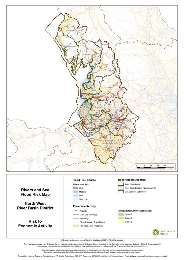
Flooding from rivers and the sea
National Flood Risk Assessment (NaFRA) is an assessment of flood risk for England and Wales
produced using local data and expertise. It shows the chance of flooding from rivers and the sea
(both along the open coast and tidal estuaries). The data is presented in flood risk likelihood
categories, which indicate the chance of flooding in any given year.
High - greater than or equal to 1 in 30 (3.3%) chance in any given year
Medium - less than 1 in 30 (3.3%) but greater than or equal to 1 in 100 (1%) chance in any given
year
Low - less than 1 in 100 (1%) but greater than or equal to 1 in 1,000 (0.1%) chance in any given
year
Very Low - these properties may have a greater than 1 in 1,000 chance of flooding in any given
year if defences weren’t present. However, in reality the chance of flooding is reduced below a 1 in
1,000 chance by defences which NaFRA analysis includes.
The computer model used to produce NaFRA results estimates the likelihood of flooding from
rivers and the sea, taking into account defences and the chance that they can fail or be
overtopped. The results can be used in conjunction with receptor data (number and type of
16 of 97properties and infrastructure) to estimate the consequences and economic damage associated
with flooding from rivers and the sea.
Flooding from reservoirs
Reservoir flood risk maps show the area that could be flooded if a large reservoir were to fail and
release the water it holds. A large reservoir is one that holds over 25,000 cubic metres. This is a
worst case scenario.
Flooding from surface water
The maps and statistics contained in this plan are based on the Updated Flood Map for Surface
water (UMfSW) published in December 2013.The UMfSW assesses a range of flooding scenarios
(annual probability of flooding is shown in brackets):
High -1 in 30 (3.3%)
Medium - 1 in 100 (1%)
Low - 1 in 1000 (0.1%)
The UMfSW replaced the ‘Areas Susceptible to Surface Water Flooding’ maps produced in 2010
by the Environment Agency.
17 of 972 What is a Flood Risk Management
Plan?
Flood risk management plans highlight the hazards and risks from rivers, the sea, surface water,
groundwater and reservoirs and set out how RMAs will work together with communities to manage
flood risk.
What is the flood risk management plan for?
Flood Risk Management Plans (FRMPs) are produced every 6 years and describe the sources and
risks of flooding within a river basin district and catchment. They also include information on how
RMAs plan to work together with communities and businesses to manage and reduce flood risk.
Over the 6 year planning cycle the FRMP will help promote a greater awareness and
understanding of the risks of flooding, particularly in those communities at high risk, and encourage
and enable householders, businesses and communities to take action to manage the risks. FRMPs
along with River Basin Management Plans (RBMPs) help all those involved in managing water to
make decisions that are best for people and the environment.
Why are flood risk management plans being prepared?
This is the first cycle of implementing the Flood Risk Regulations 2009. As a result of this
legislation, lead local flood authorities (LLFAs) must prepare FRMPs in Flood Risk Areas, where
the risk of flooding from local flood risks is significant (as identified in Preliminary Flood Risk
Assessments (PFRAs)) for instance from surface water, groundwater and ordinary watercourses.
The Environment Agency is required to prepare FRMPs for all of England covering flooding from
main rivers, the sea and reservoirs. Further information on what is a flood risk management plan
can be found on the GOV.UK website.
Flood risk and coastal erosion management activities require careful planning to ensure that
appropriate, sustainable, options are selected and that they are implemented properly. Actions
should be planned effectively, for the long-term, and provide a clear picture of what will be done to
manage risk and provide multiple benefits. This may include, for example, linking with other plans
such as RBMPs and supporting biodiversity, habitat creation or improving water quality. The
Environment Agency and LLFAs are developing FRMPs by drawing existing information together
and building on existing Flood and Coastal Erosion Risk Management plans such as: Catchment
Flood Management Plans (CFMPs), Shoreline Management Plans (SMPs) and Local Flood Risk
Management Strategies (LFRMS) (see Figure 2).
What the plan does
The FRMP will help deliver the requirements of the National Flood and Coastal Erosion Risk
Management Strategy in England by setting out the measures to manage flood risk now and in the
future. The FRMP will:
Help develop and promote a better understanding of flood and coastal erosion risk
Provide information about the economic and environmental benefits to inform decision
makers
Identify communities with the highest risk of flooding so that investment can be targeted at
those in most need
Measures (actions) in FRMPs do not all have secured funding and are not guaranteed to be
implemented. Money is allocated to all RMA measures in the same way and is based on current
Government policy that gives the highest priority to lives and homes.
18 of 97Planning Policy and Building National FCERM Policy (Defra)
Regulations (DCLG)
EU DIRECTIVES
Floods Directive
Flood Risk
Management Plans
Local FCERM Strategies
Water Framework Dir
River Basin
Management Plans
Catchment flood risk
and coastal erosion
management planning
Strategic flood risk (CFMPs, SMPs)
assessments
Long term planning for Other relevant plans
all sources of flood risk
The planning & coastal erosion Surface Water
system (local plans, Management Plans/
neighbourhood water level
plans) management plans
Flood risk
National FCERM
assessments Habitat Creation
Strategy (England)
Programme
Planning applications Sustainable Infrastructure
FCERM Schemes
and decisions community management plans
strategies / local
strategic
partnerships
Figure 2 Flood Risk Management Plans and their relationship to other planning initiatives (taken from the National
Flood and Coastal Risk Management Strategy for England) 19 of 97What types of flood risk are included in the flood risk management
plans?
The FRMP covers the flood risks that the RMAs are responsible for.
The Environment Agency has worked in partnership with other RMAs to pool the information
needed to develop the FRMP. Some RMAs have a statutory duty to produce a FRMP as they have
areas designated as Flood Risk Areas. Local surface water risk information is only included where
lead local flood authorities have a statutory duty to produce a FRMP or where they have
volunteered information. Those that are included are detailed in Table 3 and Table 4.
Areas of significant ‘local flood risk’ were identified from historic flood records and analysis of
potential future flooding from surface water, groundwater and ordinary watercourses. These ‘Flood
Risk Areas’ were designated on the basis of there being at least 30,000 people in properties at risk
of flooding, or 150 critical services (for example - schools, hospitals, nursing homes, power and
water services). This was as shown by locally agreed surface water flood maps produced in 2010
by the Environment Agency and supplemented with data from Lead Local Flood Authorities where
available.
Table 3 Flood Risk Areas in North West river basin district and LLFAs contributing to this
FRMP
Flood Risk Area information Lead Local Flood Authorities
Bolton Metropolitan Borough Council, Bury
Metropolitan Borough Council, Manchester City
Council, Oldham Metropolitan Borough
Council, Rochdale Borough Council, Salford
Greater Manchester Flood Risk Area City Council, Stockport Metropolitan Borough
Council, Tameside Metropolitan Borough
Council, Trafford Metropolitan Borough
Council.
Liverpool City Council, Sefton Metropolitan
Liverpool and Sefton Flood Risk Area Borough Council
Wigan Metropolitan Borough Council, Cumbria
County Council, Lancashire County Council,
Blackpool Borough Council, Blackburn with
Darwen Council, Cheshire East Council,
Cheshire West and Chester Council,
Voluntary information
Warrington Borough Council, Halton Borough
Council, St Helens Metropolitan Borough
Council, Knowsley Metropolitan Borough
Council, Wirral Metropolitan Borough Council,
Staffordshire County Council.
Table 4 RMAs who have voluntarily provided information for the North West FRMP.
Voluntary information Organisation name
Wigan Metropolitan Borough Council, Cumbria County
Council, Lancashire County Council, Blackpool Borough
Council, Blackburn with Darwen Council, Cheshire East
Lead Local Flood Authorities Council, Cheshire West and Chester Council, Warrington
Borough Council, Halton Borough Council, St Helens
Metropolitan Borough Council, Knowsley Metropolitan
Borough Council, Wirral Metropolitan Borough Council.
Water Company United Utilities
20 of 97Find out more
National Flood and Coastal Erosion Risk Management Strategy
https://www.gov.uk/government/publications/national-flood-and-coastal-erosion-risk-
management-strategy-for-england
Flood Risk Management Plan Guidance
https://www.gov.uk/government/publications/flood-risk-management-plan-guidance
Flood and Coastal Change
https://www.gov.uk/topic/environmental-management/flooding-coastal-change
Interactive flood maps
http://maps.environment-agency.gov.uk/wiyby/wiybyController?ep=maptopics&lang=_e
21 of 97Figure 3 Sources of flood risk information included in this FRMP
22 of 973 How the plan has been developed
The approach to developing flood risk management plans
In 2013 the Government agreed that the preferred approach to developing FRMPs would be for
the Environment Agency to work in partnership with other RMAs, in particular LLFAs, to pool
information to develop an overall plan for managing all sources of flood risk and coastal erosion. In
preparing this FRMP, RMAs have built on relevant information from existing work (see Figure 2
and Table 3, Table 4 and Table 5). Of particular importance are the Local Flood Risk Management
Strategies developed by LLFAs, Catchment Flood Management Plans (CFMPs) and Shoreline
Management Plans (SMPs). In drawing measures together, RMAs have revisited priorities and
ensured that there is a shared understanding of the risks and how best they can be managed.
The Environment Agency is co-ordinating the development of this FRMP with the RBMP so that
there is an integrated approach to overall water management for the benefit of people, the
environment and the economy.
Table 5 shows the sources of FRMP information. These plans remain active. The future need for
Catchment Flood Management Plans (CFMPs) as the strategic plan for river and estuary flooding
is being reviewed in 2015 and 2016. As with all of the plans listed in Table 5, all relevant actions
have been brought together by FRMPs. This is the case with CFMP actions. Irrespective of the
review, the actions will be being taken forward by the FRMP. The CFMP long term policies have
not been carried forward.
Find out more
Interactive flood maps
http://maps.environment-agency.gov.uk/wiyby/wiybyController?ep=maptopics&lang=_e
River Basin District Maps
https://www.gov.uk/government/collections/river-basin-districts-flood-risk-maps
Table 5 Sources of FRMP information according to flood risk
Flood risk Existing plans and FRMP information
Flooding from main rivers Catchment Flood Management Plans:
Alt and Crossens, Derwent, Douglas, Irwell, Kent
and Leven, Lune, Mersey Estuary, Ribble, South
West Lakes, Upper Mersey, Weaver and Gowy,
Wyre
Flooding from the sea and along estuaries, Shoreline Management Plans:
Coastal erosion Great Ormes Head to Scotland , North West and
North Wales
Flooding from Reservoirs Reservoir Plans:
Flood Risk Maps – North West river basin district
Flooding from surface water, Local Flood Risk Management Strategies:
groundwater and ordinary watercourses Strategies prepared by 24 Lead Local Flood
Authorities across the North West River Basin
District. Full list in Annex 2.
23 of 97Consultation and engagement
Consultation and engagement on this FRMP helped improve, inform and shape the plan. By
consulting others we have reached a better final plan. National public consultation took place
October 2014 – January 2015.
A draft FRMP was circulated to the LLFAs in the North West river basin district and to United
Utilities, to allow them to provide any comments prior to a public consultation. The Liaison Panel
for the North West River Basin Management Plan was briefed as the FRMP developed. This panel
represents a wide range of stakeholders for the key sectors and catchment partnerships including
local councils, Water Company and agricultural and environmental interests. Panel members share
information and views between the panel and their sector/wider partnership and vice-versa.
Consultation document 12h: Consultation on the draft update to the flood risk management
plans - summary response document. https://consult.environment-
agency.gov.uk/portal/ho/flood/draft_frmp/consult?dm_i=1QGB,3R34C,KI58VF,DICTE,1
Consultation document 12i: https://www.gov.uk/government/consultations/update-to-the-draft-
river-basin-management-plans
Objective setting
Flood Risk Management Plans (FRMPs) contain objectives for managing flood risk. Objectives are
a common set of goals agreed by risk management authorities. They state the main ways in which
work is directed to make a difference and reduce flood risk. They cover people, the economy and
the environment. The objectives are split into the 3 categories to help demonstrate the balance of
objectives across the plans but the categories aren’t assigned a weighting in the FRMP. Objectives
are used to plan and prioritise investment programmes to target investment to the most at risk
communities. Prioritisation is then done at an England wide level and takes into account the risk
but also considers other factors such as cost benefits, the level of investment to date and other
aspects such as the potential for external funding opportunities.
The North West FRMP contains 2 sets of objectives, which outline the main areas where RMAs
want to make improvements. One set of objectives applies for managing risk from rivers and the
sea, and the other set is for managing risk from local sources of flood risk (surface water,
groundwater and ordinary watercourse). The objectives are found in Section 8
The objectives in the North West Flood Risk Management Plan are based on a combination of the
14 Catchment Flood Management Plans (CFMP) individual sets of social, economic, and
Environmental objectives which were established through the CFMP engagement and consultation
processes.
Six year investment programme
In December 2014 the government set out a 6 year plan for investment in flood and coastal
erosion risk management (2015/16 to 2020/21). The latest published figures show the current
funding profile of each year and the published programme can be found here. Measures from the 6
year investment programme are included in this FRMP.
Each year Risk Management Authorities (local councils, Internal Drainage Boards, highway
authorities, and water and sewage companies) are invited to submit details of proposed FCERM
capital works to the Environment Agency. These proposals are combined with Environment
Agency proposed schemes to form a programme of work. Investment in FCERM is prioritised
according to government policy, and in line with the government’s National FCERM Strategy and
HM Treasury Green Book on economic appraisal. Government policy gives the highest priority to
lives and homes and all FCERM schemes should at least have a benefit cost ratio greater than
1:1. All FCERM schemes are prioritised against a consistent set of criteria applied to all risk
management authorities (RMAs). This ensures a fair distribution of government funding based on
agreed priorities, principles and needs.
24 of 97FCERM schemes are normally funded with Flood Defence Grant in Aid from Defra, partnership
funding and Local Flood Defence Levy raised by Regional Flood and Coastal Committees. FCERM
schemes can also be funded through other private contributions and local funding sources. Where
FCERM projects can help to regenerate an area and support economic growth, funding may also
be available from other sources. This can include European Structural Investment Fund, Growth
Fund through the Local Enterprise Partnership and Community Infrastructure Levy through Local
Authorities. In addition to FDGiA for FCERM schemes, Internal Drainage Board activities are
predominantly funded by the local beneficiaries of the water level management work they provide.
Long term investment scenarios
The Environment Agency’s long-term investment scenarios study published in December 2014,
presents a new analysis of the costs and risks of flood and coastal erosion risk management in
England. The study sets out the link between national investment in flood and coastal erosion risk
management, and the outcomes in terms of economic risk and numbers of properties at risk. The
study found that the annual economic ‘optimum’ investment need over the next 10 years is broadly
in line with current expenditure (about £750 million, including public and third party contributions).
The study shows that over the next 50 years optimal investment in FCERM is expected to rise by
10-20% (in present day terms). A key finding of the study is that even if average annual
investment is sustained at an optimal level there will still be significant numbers of properties at
high and medium flood risk in 50 years time meaning new and innovative approaches will be
needed. LTIS estimates that, by 2021, the 6 year programme could reduce overall flood risk by up
to 5% on the assumption that planned capital, maintenance and incident management activities
are maintained. The National Flood Resilience Review is considering infrastructure and future
investment strategy across England to pinpoint where defences and modelling need strengthening.
This will allow us to take prompt action.
Flood and coastal risk management and agriculture
Land drainage for agricultural purposes is an important element of operational activity in flood and
coastal erosion risk management. Today the prime driver for Government investment in flood and
coastal management is one of risk reduction to people and property, and for the protection of the
environment. Investment is prioritised according to government policy, the National Flood and
Coastal Erosion Risk Management Strategy and HM Treasury Green Book on economic appraisal.
Government policy gives the highest priority to lives and homes. Agricultural drainage and water
level management work continues to be important particularly in low lying areas and this work is
predominantly undertaken by farmers and landowners, and where they exist, Internal Drainage
Boards. The work of Internal Drainage Boards through managing water levels and maintaining
watercourses and structures, can also manage and reduce flood risk to people, property and
infrastructure.
Strategic Environmental Assessment and Habitats Regulations
A Strategic Environmental Assessment (SEA) was undertaken to consider the significant
environmental effects of the flood risk management plan. Natural England, English Heritage and
the Marine Management Organisation were consulted on the scope of the proposed assessment in
December 2013, and the environmental report sets out the results of the SEA. The report
describes the environmental effects that are significant within the river basin district and identifies
measures to mitigate any adverse effects. Opportunities to improve the environment are also
considered. The SEA took account of the environmental effects of flood risk management
measures in the FRMP. The focus was on the combined effects of the programme of protection
measures across a catchment or flood risk area, rather than individual measures at specific
locations.
Using the same assessment approach for both the RBMP and FRMP allows us to compare the
environmental effects directly and consider the interaction between the two plans. The likely
positive impacts of the FRMP are identified in the SEA, as well as mitigation required to manage
the negative effects and opportunities to deliver greater environmental benefits. Indicators are also
25 of 97You can also read