Cornwall AONB Unit 01872 322350 www.cornwallaonb.org.uk
←
→
Page content transcription
If your browser does not render page correctly, please read the page content below
Cornwall AONB Unit
01872 322350
info@cornwall-aonb.gov.uk
www.cornwallaonb.org.uk

                                                                                                                       Cornwall Area of Outstanding Natural Beauty - Management Plan 2016 - 2021: Local Sections
500 of these brochures were printed using             carbon is locked that would otherwise be
vegetable based inks on Cocoon Offset, a 100%         released. These protected forests are then able to
recycled FSC paper which is carbon balanced. By       continue absorbing carbon from the atmosphere.
using Cocoon Offset rather than a non-recycled        Referred to as REDD (Reduced Emissions from
paper, the environmental impact was reduced           Deforestation and forest Degradation), this is now
through: 194kg diverted from landfill, 323kg carbon   recognised as one the most cost-effective and
saved, land preserved 27.13sq. metres, 4045 litres    swiftest ways to arrest the rise in atmospheric CO2
less water used, 373kWh less energy used and          and global warming effects.
316kg less wood used.
                                                      Created by Leap, a Cornwall based design studio
Carbon balancing by The World Land Trust              that believes in designing with purpose and
tackles climate change through projects that          creating work that matters: leap.uk.net
both offset carbon dioxide (CO2) emissions and        A certified B Corp: bcorporation.uk
conserve biodiversity.
                                                      Calculations are based on a comparison between the recycled
                                                      paper used versus a virgin fibre paper according to the latest
Through land purchase of ecologically important       European BREF data available.
standing forests under threat of clearance,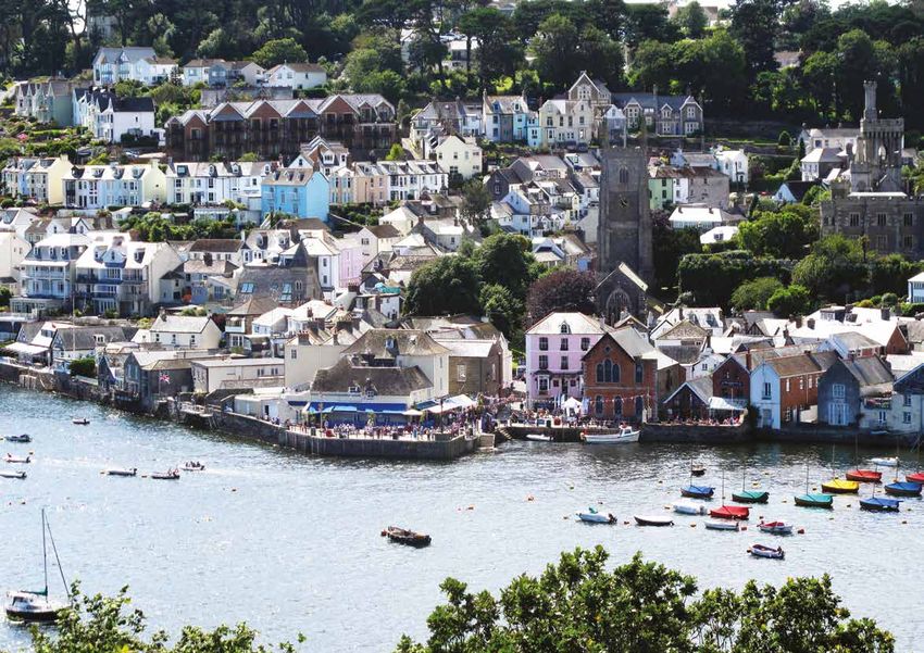
Contents

                                          CORNWALL AREA OF NATURAL BEAUTY MANAGEMENT PLAN 2016 - 2021: LOCAL SECTIONS
02         Local Sections

04         1 Hartland

08         2 Pentire Point to Widemouth

13         3 The Camel Estuary

19         4 Carnewas to Stepper Point
           (formerly Trevose Head to
           Stepper Point)

23         5 St Agnes

27         6 Godrevy to Portreath

33         7 West Penwith

40         8 South Coast Western

48         9 South Coast Central

54         10 South Coast Eastern

60         11 Rame Head

64         12 Bodmin Moor

Obby Oss - Paul Glendell

                                          1
Local sections
    Purpose                                                Local policies
    The local sections detail the management               Each local section includes local policies which
    principles that are specific to each of the local      identify the specific management objectives
    sections of the Cornwall AONB. The local area          that are applicable to the local section over
    policies should always be read in conjunction          the next five years.
    with the policies set out in the strategic policies
    of the plan that address Cornwall-wide AONB            The local policies are required to:
    management matters.
                                                           •   achieve the purposes of the
    Statements of significance                                 AONB designation;

    The local sections contain a statement of              •   deliver the purposes of the
    significance which sets out the qualities and              AONB Management Plan;
    characteristics that makes that section as a whole
    recognisable, distinctive and different from           •   reflect local level detail and
    surrounding areas. The statement of significance           management needs; and
    will not necessarily refer to individual features
    but this does not mean that such features are          •   be realistic.
    not important or do not form a key component
    of the AONB landscape. The statement of                The local policies can be used for a range of
    significance is not a complete inventory, more a       purposes. For example they can provide guidance
    summary of the landscape character and scenic          and inform the assessment of development
    beauty of the protected landscape. The statement       proposals in or adjoining the local section or
    of significance can be used as landscape character     they can promote projects and funding
    evidence base to judge impact (or harm) to the         applications that support the purposes of
    AONB from development or other activity and as         the AONB designation.
    a guide to help tailor positive activity to conserve
    and enhance the area.                                  Each local section identifies a number of matters
                                                           that are considered to be impacting upon the
                                                           condition of the special features and attributes in
                                                           that particular section of the Cornwall AONB and
                                                           any of the known management groups, activities
                                                           and/or strategies in place for the area. The local
                                                           policies will seek to address poor condition and
                                                           support good management, supported by the
                                                           overall strategic policies.

2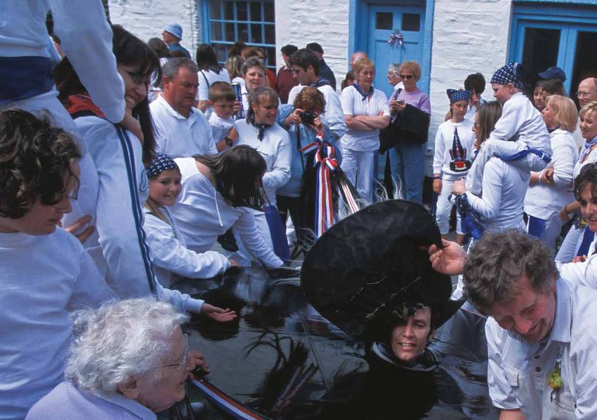
CORNWALL AREA OF NATURAL BEAUTY MANAGEMENT PLAN 2016 - 2021: LOCAL SECTIONS
                                                                                                       3
                                                                              Rough Tor - Tim Knight
1 Hartland
                                                         rock stratum of folded and faulted ridges. These          1.
                                                         shores are punctuated occasionally by sandy
                                                         coves and beaches at the mouths of stream
                                                         valleys, notably at the aptly named Sandymouth.
                                                         Inland, the land rises gently to a ridge of 200m
    Location                                             and is dissected by numerous streams which
                                                         form deeply incised valleys containing streams
    This small section of the AONB runs northwards       that cascade as small waterfalls onto the rocky,
    from just above Bude to the Cornwall border          narrow, boulder strewn shoreline below. Coastal
    with Devon and has strong links with the             heathland fringes the cliff tops, particularly
    Hartland Peninsula, which is part of the North       in the north, whilst the steep valley sides are
    Devon AONB. The boundary more or less follows        colonised with broadleaved woodland, some
    the A39 trunk road (Atlantic Highway) and            ancient, as found in the Coombe and Marsland
    includes the coastal strip from Marsland in the      Valleys. The Culm grassland found on the
    north to Menachurch Point in the south.              unimproved wet pasturelands of the inland
                                                         plateau has an acidic quality producing a unique
                                                         flora, which is nationally rare.
    Extent
                                                         This is a pastoral landscape with the field pattern
    At approximately 2,600 hectares or just over
                                                         revealing ancient enclosures. Many of the hedges

                                                                                                               Trelawn  ey
    25.9 square kilometres it forms just under three
                                                         have now been removed to provide access for
    percent of the Cornwall AONB.
                                                         farm machinery and larger areas of land for
                                                         arable crops although further inland there is still
    Cornwall and Isles of Scilly
                                                                                                                     g of
                                                         a significant amount of dairy farming.

                                                                                                                 - The Son
    Landscape Character Assessment

                                                                                                                           Men
    2005-2007                                            Small hamlets and isolated farm holdings, such

                                                                                                               the Western
                                                         as the National Trust property at Stowe Barton,
    Character Areas: CA37 Western Culm Plateau           make up this sparsely populated section of
    and CA38 Bude Basin.                                 the Cornwall AONB and the lack of populace            by the National Trust where the Reverend
                                                         further emphasises its remoteness. Local slate        Hawker used to compose his sermons and poetry.
                                                         and sandstone, together with cob and thatch,

    Statement of                                         are characteristic of the homes in this area.
                                                         Originally these were lime washed or slate-hung
                                                                                                               Views along the coastline are breath-taking and
                                                                                                               extensive. On a clear day Lundy Island can be

    Significance
                                                         but are now more commonly rendered.                   seen out to the northwest. Further south, the
                                                         At Morwenstow, the Norman church is built into        coastal plateau decreases to a much lower cliff
                                                         the valley side with its tower on the seaward         line with views southward towards Bude.
    This section of the AONB is a high coastal plateau   side. Its vicarage, notable for its many chimneys
    of carboniferous sandstones and slates known as      of differing styles, was once home to the late        This section of the Cornwall AONB is one of the
    the Culm Measures. The cliffs are sheer; reaching    Reverend Robert Stephen Hawker who wrote              less well known AONB areas but its dramatic
    140m in some places and are intensely folded         Trelawney – The Song of the Western Men.              coastal cliffs and unusual rock formations,
    and faulted. The sea has sculpted a striking         A little way north from the vicarage, on a steep      together with its ancient history provides an
    wave-cut platform, which at low tide reveals a       sided coastal cliff, sits Hawker’s Hut, now owned     interesting and unique landscape.
4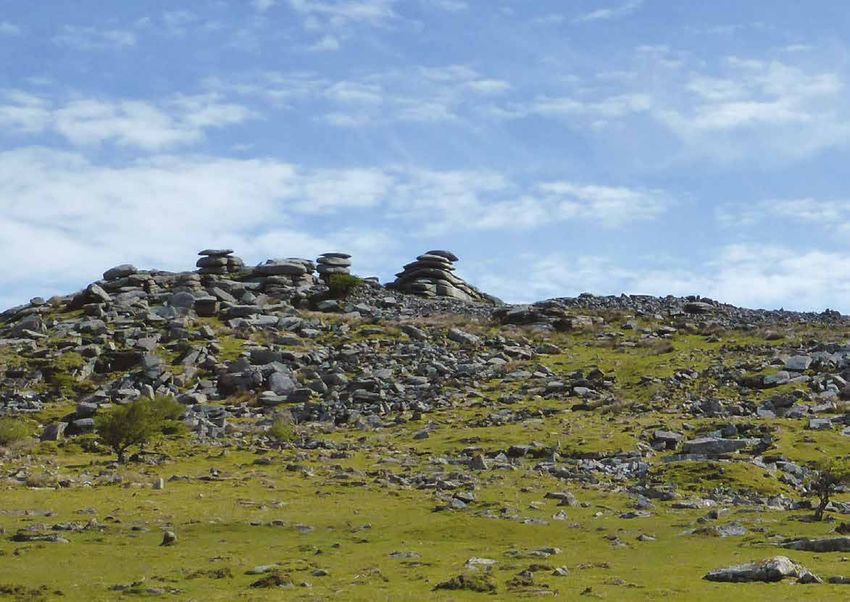
CORNWALL
                                                                                  HARTLAND
                                                                                       AREA OF NATURAL BEAUTY MANAGEMENT PLAN 2016 - 2021: LOCAL SECTIONS
2.

     1. RS Hawker - courtesy of Cornwall Archives and Local Studies Service
     2. Morwenstow Church

                                                                              5
Management                                                               Condition

    •   The National Trust manages land specifically around              •    The Council for the Protection of Rural England’s
        the coastline at Morwenstow and from Duckpool                         tranquillity, intrusion and night blight mapping shows
        to Sandymouth.                                                        Hartland to be the most ‘undisturbed’ section of the
                                                                              Cornwall AONB.
    •   Kilkhampton Parish Plan was prepared in 2003.
                                                                         •    The large structures of GCHQ Bude at Morwenstow are
    •   Cornwall Biodiversity Initiative plans include support                visually intrusive.
        for the now halted ‘Atlantic Coast and Valleys Project’,
        which aimed to enhance, extend and link characteristic           •    The Environmental Records Centre for Cornwall and
        coastal habitats.                                                     the Isles of Scilly (ERCCIS) report that few areas of culm
                                                                              grassland now remain in north Cornwall.
    •   The North Devon AONB Management Plan 2014-19 has
        been published and includes the Hartland Peninsula.              •    Scrub and bracken encroachment affects coastal
                                                                              marginal land especially within the coastal
    •   The sustainable tourism project ‘Explore the Coast’                   valleys leading to loss of biodiversity and
        supports car free access and the provision of greater                 changes in landscape.
        information on the North Devon AONB.
                                                                         •    Sycamore has become established in
    •   Much of the coastline in the Hartland section of the                  broadleaved woodlands.
        Cornwall AONB is included in the ‘Steeple Point to
        Marsland’ SSSI (Site of Special Scientific Interest).            •    A Romano-British forge and medieval port for
                                                                              Kilkhampton were discovered on the beach at Duckpool
    •   The sea off Hartland Point to Tintagel has been                       in the 1980s subsequently as a result of continued
        recently designated as a Marine Conservation Zone.                    erosion by the sea this notable find is now at risk
                                                                              and could eventually be lost.

                                                                         •    Dutch elm disease has had a significant impact on
                                                                              hedgerow elm in this area affecting habitat connectivity
                                                                              and landscape character.

                                                      View to the sea near Morwenstow

6
CORNWALL
Hartland Local Policies

                                                                                                                                                          HARTLAND
                                                                                                                                                                AREA OF NATURAL BEAUTY MANAGEMENT PLAN 2016 - 2021: LOCAL SECTIONS
H1. 01 Require all development to maintain the sparsely populated                  and the native broadleaved woodland found, for example at
       settlement pattern and tranquil characteristics of this                     Coombe Valley, Stanbury, The Tidna, and Marsland Valley.
       section of the Cornwall AONB and respect local vernacular                   Consider the small scale planting of local provenance native
       and use of materials that makes this area distinctive. Support              tree species such as Sessile Oak, Hazel and Alder to act as a
       new uses of isolated local vernacular buildings, where this                 future seed source for native woodland establishment
       can be achieved whilst maintaining character, in order to                   where this is currently absent or sparse to assist subsequent
       achieve their retention.                                                    natural regeneration.

H1. 02 Support the conservation and enhancement of the                     H1. 07 Encourage measures to reduce the encroachment of scrub
       undeveloped character of the coast, in order to retain its                 and bracken in the coastal marginal land and support the
       rugged and simple tranquillity.                                            encouragement of culm grassland in a manner that is consistent
                                                                                  with conserving and enhancing local landscape character
H1. 03 Seek to maintain current low levels of light pollution in order            and biodiversity.
       to maintain dark night skies. (This being the most ‘undisturbed’
       Cornwall AONB Section according to the Council for the              H1. 08 Explore the future management requirements for the satellite
       Protection of Rural England’s tranquillity, intrusion and night            dishes at GCHQ Bude, seeking opportunities to reduce their
       blight mapping records).                                                   current visual impact and restore the natural landscape over the
                                                                                  medium to long term.
H1. 04 Promote joint working with the North Devon AONB Partnership
       on the action plan for the Hartland Peninsula and the ‘Explore      H1. 09 Seek opportunities to increase the awareness and protection
       the Coast’ project.                                                        of the heritage of the area, in order to promote, conserve and
                                                                                  enhance landscape character and natural beauty, for example,
H1. 05 Encourage sensitive management and explore measures                        the links with Reverend Robert Stephen Hawker and the
       to reduce and remove the establishment of Sycamores in                     Romano-British forge and medieval fort at Duckpool, paying
       native broadleaved woodlands for example at Coombe Valley,                 particular attention to the investigation and recording of coastal
       Stanbury, the Tidna, and Marsland Valley, in a manner that                 heritage features such as at Duckpool that may be impacted
       is consistent with conserving and enhancing local landscape                upon by coastal change and storms due to climate change.
       character and biodiversity and provided regeneration can
       occur using natives.                                                H1. 10 Seek a reduction in landscape and visual impacts of
                                                                                  tourism including better integration of holiday sites, visitor
H1. 06 Support a wider landscape-scale approach to extending and                  infrastructure and signage by respecting local character
       connecting currently fragmented, locally characteristic habitats.          in external works, landscaping, site design and layout. Pay
       These include culm grassland, maritime cliff and slope, lowland            particular attention to the increase in scale, massing and
       heathland, species-rich grasslands and heath in coastal valleys,           associated development for example at Duckpool, Sandymouth
                                                                                  and Morwenstow.

                                                                                                                                                       7
2 Pentire                                            Statement of                                        into two sections, the old medieval village which
                                                                                                             evolved around Bottreaux Castle higher up the

    Point to                                             Significance
                                                                                                             valley and the small 19th century sheltered
                                                                                                             port on the valley floor which was of strategic

    Widemouth
                                                                                                             importance as the only sheltered harbour
                                                         The coastline throughout this section is craggy     between Bude and Padstow. There has been
                                                         with dramatic contorted cliffs and folded slates,   considerable development over the years on
                                                         shales and volcanic rocks with some sandstone       the more elevated land higher up the valley as
                                                         to the north, there are also some interesting       well as following on from the 2004 flood when
                                                         coastal features such as rocky stacks, arches,      an estimated two million tonnes of floodwater
    Location                                             headlands, caves and blowholes interspersed         flowed down the River Valency, following a flash
                                                         with rocky coves and a few sandy beaches such       flood, which affected Boscastle, Rocky Valley and
    The coastal strip between Pentire Point in the       as at Trebarwith Strand and Crackington Haven.      Crackington Haven.
    south and Widemouth in the north forms this          The highest land at 223m is in the north at the
    section of the AONB. Inland it is bounded by the     aptly named ‘High Cliff’ near Tresparrett on        The most notable historic feature along this
    B3314 in the south and the A39 in the north.         the carboniferous sandstones and shales; the        section of the Cornwall AONB can be found at
                                                         cliff line then gradually reduces in height to      Tintagel. Here the coastline is rugged,
    Extent                                               approximately 70-80m at Pentire Point.              consisting of Devonian slate and volcanic rocks
                                                                                                             of the carboniferous Tintagel group, which
    Approximately 11,900 hectares or 119 square          Behind the coastline, the undulating coastal        are folded and faulted, forming stacks and
    kilometres this area forms just over 12 percent      plateau is incised with steep sided secluded        small islands. Tintagel Island with its rounded
    and is the largest section of the Cornwall AONB      valleys and streams that flow down to sea level     headland connected by a narrow isthmus to the
    on the north coast. It is 30 km long and varies in   such as at Boscastle, Crackington Haven and         main coastline contains the famous ruins of the
    width from approximately five kilometers near        Millook. The valleys extend well inland, creating   12th century Tintagel Castle, standing high on
    Boscastle to 0.5km at Pentire Point.                 a secluded landscape with small farming hamlets.    the cliffs, giving rise to the legend of King
                                                         The microclimate of the sheltered valleys is in     Arthur and providing a very popular global
    Cornwall and Isles of Scilly                         sharp contrast to the open farmland exposed         tourism destination.
    Landscape Character Assessment                       to the strong sea winds on the coastal plateau
                                                         where there is limited tree growth. Land use        Tintagel and Bossiney form large areas of
    2005-2007                                            tends to be mainly limited to arable and pasture    settlement which have grown from small
                                                         inland with coastal heathland dominating the        medieval communities to industrial villages
    Character Areas: CA31 Upper Tamar and Ottery                                                             supporting the surrounding slate quarries and
    Valleys; CA33 Camel and Allen Valleys; CA34,         cliffs. The sheltered and relatively inaccessible
                                                         coves of this section are particularly important    have now evolved to support the ever
    Camel Estuary; CA35, Kellan Head to Millook                                                              increasing tourism trade. However, the
    Haven Coast; CA36 Delabole Plateau; CA37             safe habitat for Cornwall’s globally significant
                                                         population of grey seals.                           surrounding land still tends to support small
    Western Culm Plateau; CA38 Bude Basin.                                                                   agricultural hamlets linked by narrow lanes
                                                         This section of the AONB contains some              and high hedges with a medieval pattern of
                                                         important historical features, such as the          enclosure. The small coastal settlement at
                                                         unaltered and still farmed medieval open field      Trebarwith, connected with the old harbour
                                                         ‘stitchmeal’ system of Forrabury Stiches near       cove of Port William, is also a popular summer
                                                         Boscastle. As a settlement, Boscastle is divided    tourist destination.

8
CORNWALL
South and west of Trebarwith the AONB

                                                         PENTIRE
landscape narrows and consists of steep

                                                               AREA
seaward sloping cliffs dissected by short

                                                                 POINT
streams, which form ‘V’ shaped valleys. There

                                                                    OFTO
are few settlements, other than a few scattered

                                                                       NATURAL
                                                                         WIDEMOUTH
farm holdings in the north. In contrast, the
communities of Port Isaac and Port Gaverne in

                                                                               BEAUTY MANAGEMENT PLAN 2016 - 2021: LOCAL SECTIONS
the west continue to attract many visitors who
have been inspired to visit by a popular television
series, bringing inevitable traffic congestion
during peak periods on narrow lanes.

Slate is the characteristic local building and
hedging material, varying from the mid hues of
Delabole slate to the darker shades sourced at
Trebarwith. The local slate industry led to the
expansion of some villages such as Treknow
and Trewarmett and the numerous small-scale
disused historic slate quarries are now a feature
of the coastal landscape although slate quarrying
operations continue within and close to the
AONB at a small number of sites.

There is a noticeable lack of tree cover due to the
exposure to coastal winds in this section. Land
use is mainly agricultural grazing in small to
medium sized fields of medieval origin although
modern farming practice has resulted in some
larger fields being created as can be seen on
land behind Port Quin. Coastal heathland is a
significant component of this area with rough
and scrubby land leading inwards from the coast.
At Rumps Point towards the extreme west of the
section are the remains of an Iron Age cliff
castle. This is a quiet and unspoilt area with
much of the coastal land under the management
of the National Trust and despite the inevitable
impact of tourism on the coastal landscape this
section of the AONB still retains its unspoilt
rural character.

                                                      9
Management
• The National Trust manages significant stretches of the • The Polzeath Voluntary Marine Conservation Area
coast from Pentire Head to Port Quin and the Rocky (VMCA) seeks to raise awareness, enjoyment and
Valley in the west and from Crackington Haven to interest in the marine environment including the
Dizzard in the east. intertidal habitats and splash zone.
• Parish Plans exist for St Endellion and St Kew. • The offshore area from ‘Hartland Point to Tintagel’
has recently been designated as a Marine
Conservation Zone.
• St Endellion, St Gennys, St Minver Lowlands and
Highlands and Tintagel are all in the process of • The coast from Trebarwith to Widemouth is a
preparing Neighbourhood Development Plans. designated SSSI.
• Following the extensive damage incurred by the • A coastal communities team has now formed at
2004 flood, Boscastle has been redeveloped using St. Endellion to support regeneration projects in
mostly locally characteristic building materials of the area.
local slate killas.
• Historic England manages Tintagel Castle as a
tourism destination.
• Active quarrying operations are controlled under the
Review of Mineral Planning Permissions (ROMPS).
• Some of the steeper valleys have suffered from
less intensive management resulting in a range of
developing woodland, scrub and rough ground habitats.
• Cornwall Biodiversity Initiative plans include protection
a n d
and extension of coastal rough ground habitats.
Va l l e y s
• The RSPB promote land management to support
the Corn Bunting.
t l e s
• The ‘Atlantic Coast and Valleys’ project, which has
c a s
now halted, proposed rough grazing of cliff tops and
clif f
valley sides around Trebarwith to support a traditional
farming landscape and the restoration of habitats
favourable for the return of the large blue butterfly.
10CORNWALL
Condition 1.
PENTIRE
AREA
• There has been a departure from the • Lack of management of broadleaved
POINT
local settlement pattern, vernacular and woodland on many of the steep sided valleys
OFTO
use of local materials in recent housing has resulted in sycamore colonisation e.g. at
NATURAL
WIDEMOUTH
development in Boscastle and Tintagel. Millook, Crackington and St Nectan’s Glen.
Development pressure from Polzeath has
BEAUTY MANAGEMENT PLAN 2016 - 2021: LOCAL SECTIONS
the potential to impact upon the AONB • Japanese knotweed is prevalent in Rocky
and its setting. Valley and other valley systems.
• Wind farms, including the one at Delabole, • Scrub and bracken encroachment is a
which is outside the AONB, alongside significant issue within coastal valleys
individual turbines, are clearly visible leading to loss of biodiversity and change
and have a negative landscape, visual and in the landscape.
cumulative impact on the AONB landscape.
• Loss of hedgerow elm due to disease has
• Unsympathetic restoration of former impacted on habitat connectivity and
working quarries in the area has resulted in landscape character in certain parts of this
unnecessary landscape and visual impacts. section of the AONB.
• Some major roads have taken on suburban
characteristics in their detailing.
1.Beach cave at Tintagel
2.Tintagel Castle
• Overhead wires are visually intrusive
especially in the historic settlements of Port
Isaac and Tintagel.
2.
11Pentire Point to PPW2. 05 Support a landscape scale approach to extending and
connecting currently fragmented locally characteristic
Widemouth
habitats. These include maritime cliffs and slopes,
lowland heathland, lowland meadows, coastal native
woodland, as at Dizzard, and native valley broadleaved
Local Policies woodland found for example in the Valency Valley,
Millook Woods, Crackington Haven and St Nectan’s Glen.
Consider small scale planting of local provenance native
PPW2. 01 Support small-scale existing slate quarries such as at tree species such as Sessile Oak, Hazel and Alder to act as
Trebarwith, in order to allow controlled production for a future seed source for native woodland establishment
use in local works provided that these respect landscape where this is currently absent or sparse to assist
character, topography and vegetation in their operation and subsequent natural regeneration.
restoration and minimise short and long term landscape
and visual impacts. Support further measures to protect PPW2. 06 Encourage sensitive management and explore measures to
and enhance environmental and landscape quality when arrest the establishment of sycamores in native broadleaved
existing quarrying permissions are reviewed. woodlands for example around Millook and Crackington, in
a manner that is consistent with conserving and enhancing
PPW2. 02 Seek better landscape integration of the A39, B3314, B3263, local landscape character and biodiversity and provided this
and other major roads with their rural AONB setting by can be achieved using natives.
improved planting design and management, reducing
the impact of signage and lighting, use of non-intrusive PPW2. 07 Encourage measures to reduce the encroachment of scrub
methods of traffic calming and characteristic use of local and bracken on coastal marginal land and support the
materials and hedging styles in highways work. encouragement of culm grassland in a manner that is
consistent with conserving and enhancing local landscape
PPW2. 03 Support initiatives for undergrounding visually intrusive character and biodiversity.
wirescapes, for example at Port Isaac and Tintagel.
PPW2. 08 Help to support coastal management, which promotes
PPW2. 04 Seek conservation and enhancement of the undeveloped natural processes wherever possible and support initiatives
character of the coast; for example Witches Cauldron to with communities which consider the long term future
Port Quin Bay, around High Cliff and around Dizzard in of the coast in respect to predicted effects of sea level rise
order to retain rugged and simple tranquillity and promote and increased storminess. Seek to support the delivery
the enhancement of other parts of coast for example of appropriate measures to hold the line and manage
around Tintagel, Boscastle and Port Isaac such that they realignment as identified in the Shoreline Management
return to having a more undeveloped character. Plan where they conserve or enhance the landscape
character and natural beauty of the AONB. Conserve the
undeveloped nature of the coast away from settlements.
12CORNWALL AREA OF NATURAL BEAUTY MANAGEMENT PLAN 2016 - 2021: LOCAL SECTIONS
PPW2. 09 Ensure that settlement growth to address local
needs in Polzeath enhances the settlement edge and
conserves and enhances the natural beauty of the
AONB. Ensure that the undeveloped coast between
Polzeath and the southwestern end of the section and
the setting of ‘The Rumps’ is protected. Support new
uses of isolated local vernacular buildings, where
this can be achieved whilst maintaining character, in
order to achieve their retention.
PPW2. 10 Seek a reduction of landscape and visual impacts
of tourism including better integration of existing
holiday sites, visitor infrastructure, car parks and
signage. Pay particular attention to the increase
in scale, massing, associated development and
respecting local character in external works,
landscaping, site design and layout at Polzeath,
Tintagel, Bossiney, Trewethett, and near Widemouth.
PPW2.11 Seek to improve the management of important seal
sites between Beeny Sisters and Buckator, bringing
them back into favourable condition for seals.
PPW2.12 Seek to improve the management of traffic, parking
and vehicular access in this section, including
through the promotion of car free options.
St Nectan’s Glen waterfall - Karen Smith
133 Camel Statement of the Camel Estuary provides extensive views
towards the sea and a feeling of expansiveness
Estuary Significance
where, on clear days land and sky combine.
The Camel Estuary is primarily a mixed
agricultural landscape and whilst there is a
This relatively small section of the Cornwall pattern of small irregular enclosures of medieval
AONB is defined by its distinct landscape where origin, larger fields tend to be found north of
Location the gentle undulating land slopes down into Cant Hill and at Trewornan on the River Amble.
the broad Camel Valley. The Camel Estuary is Cornish hedges enclose many of the fields, built
This AONB section includes the Camel Estuary approximately one kilometre wide between of local slate and on exposed sections the hedges
and runs west from Wadebridge to Padstow and Padstow and Rock and stretches inland for reveal the characteristic herringbone pattern.
the adjacent land. It is bounded by the A389 and around seven kilometres where it narrows The long history of human habitation is indicated
A39 to the south and west, and the B3314 to the significantly at Wadebridge but remains tidal for
northeast and extends almost as far north as the several kilometres beyond.
edge of Rock, Splatt and Tredrizzick.
The slate bedrock is exposed in low cliffs along
Extent the shore of the estuary. At low tide, mud
and sandbanks become clearly visible. Within
Covering an area of almost 2,500 hectares or 24.6 the more sheltered side waters such as Little
square kilometres it forms just over 2.5 percent Pertherick and Pinkson Creeks and at the
of the Cornwall AONB. convergence of the Rivers Amble and Camel,
the mud flats are colonised with reeds and salt
Cornwall and Isles of Scilly marsh vegetation, providing a perfect habitat
for a variety of wildlife such as over-wintering
Landscape Character Assessment wildfowl and waders. On the north side of the
2005-2007 estuary, the distinctive landmark of Cant Hill is
easily recognisable as the land rises sharply into a
Character Areas: CA19 Trevose Head and Coastal prominent rounded and steep sided hill, formed
Plateau; CA33 Camel and Allen Valleys; 34 as a result of the underlying igneous rock.
Camel Estuary.
Away from the tourist ‘hot spots’ the Camel
Estuary forms a tranquil and intimate landscape
with creeks and tributary valleys where many
small woodlands colonise the gentle slopes.
Common species found here include willow;
poplar, oak and hawthorn intermixed with gorse.
In contrast, the more open areas are exposed to
the coastal winds so woodland and hedgerows
become much less common. At its widest point,
14CORNWALL
by this area having one of the highest densities
CAMELAREA
of recorded crop mark sites in Cornwall, many
being Romano-British rounds (settlements).
ESTUARY
Overall, this is a sparsely populated landscape
OF NATURAL BEAUTY MANAGEMENT PLAN 2016 - 2021: LOCAL SECTIONS
consisting of farmsteads and hamlets in typical
medieval style where grey slate is the dominant
building material.
On the south side of the estuary the disused
railway has provided a perfect setting for
the Camel Trail, a popular cycle trail which
runs from Padstow to Wadebridge and inland
following the valley through to Bodmin, much
used and very popular with visitors and locals
alike who can appreciate this scenic and tranquil
landscape all year round.
On clear days land
and sea combine
Camel Estuary - Edward Treverton
15Management
• St Minver, St Kew and Padstow Parish Plans • The Camel Estuary Initiative, established
together with Wadebridge Town Plan have in 1994, aims to enhance and maintain the
been prepared. natural quality of the Camel by
co-ordinating effort and promoting wise
• A Neighbourhood Development Plan is use of the resource.
currently being prepared for the St Minver
Lowlands and Highlands. • The Camel Estuary Management Plan
was published by the Padstow Harbour
• The 18-mile long multi-use Camel Trail Commissioners on behalf of the users of
is managed and maintained by the estuary.
Cornwall Council.
• A Camel Valley Estuary Advisory Group
• The aims of the Cornwall Biodiversity has been established with representative
Initiative include: Coast to Coast to link from bodies with a legal responsibility for
river and valley habitats including native the estuary.
broadleaved woodlands and wetlands
from the Camel to the Fowey Estuary via river 1.
valleys around Bodmin Moor in order
to reinforce wildlife corridors. The local
aims are to extend and enhance the
Amble Marshes.
• The Amble Marshes SSSI, Water Level
Management Plan (WLMP) is being
implemented in a partnership between
landowners, the Environment Agency and
Natural England via agri-environment
schemes and in consultation with the local
community. The objective is to restore and
enhance habitat conditions for wading birds
during winter and the breeding season.
• Whilst the Camel River and Valley outside
the AONB is designated a Special Area of
Conservation, the Estuary does not have
such protection.
16CORNWALL
Condition
CAMELAREA
ESTUARY
• The Council for the Protection of Rural
OF NATURAL BEAUTY MANAGEMENT PLAN 2016 - 2021: LOCAL SECTIONS
England’s tranquillity, intrusion and night
blight mapping shows the most ‘disturbed’
(least tranquil) section of the AONB is the
Camel Estuary. This is due to the proximity
of major roads including the A389, B3314 2.
and the A39 (Atlantic Highway), which lies
partially within the AONB along with the
more urban settlements of Padstow, Rock
and Wadebridge.
• Some historic Cornish hedges have been
replaced by wire fencing although some of
this is from the division of former downland.
• Many of the broadleaved woodlands are
unmanaged and there has been a significant
loss of hedgerow elm trees due to disease,
which in turn has impacted on habitat
connectivity and landscape character.
• Development pressure from Padstow, Rock
and Splatt has the potential to impact upon
the AONB and its setting.
1. Camel Estuary - Frances Toorawa
2. Cant Hill from Camel Trail
17Camel Estuary - Barry Willis 18
CORNWALL
        Camel Estuary Local Policies

                                                                                                 CAMELAREA
                                                                                                       ESTUARY
CE3.01 Seek reduction of impacts on landscape character and tranquillity from major

                                                                                                           OF NATURAL BEAUTY MANAGEMENT PLAN 2016 - 2021: LOCAL SECTIONS
       roads such as the A39, A389 and B3314 by for example reduction in street
       lighting, reduction in signage, less intensive management of roadside vegetation,
       non-intrusive methods of traffic calming and local hedging styles and materials
       in highway works.

CE3.02 Seek retention of the quiet rural character of small lanes such as those leading
       from settlement edges and off major roads to the edge of the estuary.

CE3.03 Promote the co-ordinated management of the activities taking place on the
       Camel Trail to ensure that they do not detract from tranquillity or visual amenity,
       to the benefit of all users.

CE3.04 Support the continued reversion to marshland in the upper reaches of the
       Camel Estuary, for example at Amble Marshes, where drainage and agricultural
       improvement has taken place in order to restore to favourable condition this
       locally characteristic and significant habitat in the context of a landscape scale
       approach to the enhancement of locally significant Biodiversity Action Plan
       habitats.

CE3.05 Support proposals to enhance protection for important habitats and species
       around the estuary.

CE3.06 Seek to protect mature trees surrounding settlements for example at Padstow,
       Rock, Splatt and Wadebridge in order to conserve their contribution to local
       landscape character.

CE3.07 Encourage the active consideration of the landscape and visual impacts around
       the Camel Estuary of increasing or changing patterns of water based access,
       leisure and commercial activity and related infrastructure.

CE3.08 Support sustainable water based travel around the estuary, for example the
       continuation of the existing ferry link between Padstow and Rock.

CE3.09 Support settlement growth to Rock, Splatt and Padstow that addresses local need,
       enhances the settlement edge and conserves and enhances the natural beauty of
       the Camel Estuary and does not adversely impact upon the AONB or its setting.

                                                                                             19
4 Carnewas to Statement of The landscape pattern is comprised of mainly
medium sized fields with characteristic stands
Stepper Point Significance
of tamarisk atop Cornish hedges, following
the medieval enclosure system. The fields
here are a mix of arable land and pasture.
The variety of coastal scenery in this section Closer to the coast, the coastal heathland
is due to the diverse geology including has been incorporated into the field system
The name of this section has been changed from the hard greenstones, which form the elevated to provide larger areas for arable farming.
Management Plan 2011-2016 to better reflect its headlands as seen at Trevose Head and This in turn has produced an exaggerated
geography and was formerly called Trevose Head Stepper Point. These headlands stand slightly openness and confined semi-natural habitats
to Stepper Point. to much smaller areas along the cliffs.
above the level of the farmland. The more
easily eroded slates and shales back the bays At Bedruthan, a more substantial area of
Location and coves between the headlands as can coastal heathland has been preserved which
be seen at Harlyn Bay, Trevone, Treyarnon has enhanced the rugged qualities originally
This section of the AONB is situated on the and Mother Ivey’s Bay. There are extensive found on this stretch of the AONB coastline.
north coast and extends from the rocky coast coastal sand dunes at Constantine Bay. At The sandhills on the upper slopes of Stepper
of Carnewas Point and Bedruthan Steps, north Stepper Point, the coast curves inland towards Point and behind Hawker’s Cove, Harbour
to Trevose Head and west to Stepper Point Padstow, past the secluded Hawker’s Cove and Cove and St George’s Cove are covered with
on the west side of Padstow Bay. The section further sand dunes at Tregirls Beach, forming alkaline grassland retaining a suitable habitat
then turns south and hugs the mouth of the the western side of the expansive mouth of for a wide variety of flora and fauna.
Camel Estuary to the very edge of Padstow. It the Camel Estuary. The landscape here is
is bounded inland to the east by the B3276 to softer, in sharp contrast to the imposing and The peaceful and wild nature found in
just north of Porthcothan. indented cliffs of the much-photographed this section of the AONB is interrupted
iconic Cornish cliffscape at Bedruthan Steps sharply in places by recreational activity.
Cornwall and Isles of Scilly with its craggy rock stacks. The busy beaches of Harlyn, Treyarnon and
Landscape Character Assessment
2005-2007
Character Areas: CA19 Trevose Head and
Coastal Plateau; CA34 Camel Estuary.
Extent
This area extends to approximately 2,400
hectares or just over 23 square kilometres and
forms 2.5 percent of the Cornwall AONB.
Stepper Point near Padstow - Rose Cross
20CORNWALL
Constantine Bay are very popular for surfing
CARNEWAS
and other water based activities, whilst the
sand dunes at Constantine Bay are managed
AREATO
for golf. Prideaux Place with its grand
OFSTEPPER
Elizabethan Manor House and grounds on
NATURAL
the very edge of this section of the AONB is
registered as historic parkland and provides
POINT
BEAUTY MANAGEMENT PLAN 2016 - 2021: LOCAL SECTIONS
tranquillity in contrast to the flurry of outdoor
activity towards the coast.
The slate geology of the area is reflected in
the character of the housing. Many of the
buildings from cottages to Victorian villas are
built of slate and many of the surrounding
stonewalls are predominantly slate built in
the herringbone pattern of alternating
diagonal courses so typical of the area. The
walls that edge the lanes cut through solid
bedrock, exposing the silvery slate have
become colonised with ferns, wildflowers,
grasses and brambles.
There is evidence in this section of prehistoric
features ranging from cliff castles to barrows
as well as examples of Romano-British
rounds (settlements). Many of the small
settlements in this area have place names
beginning with ‘tre’ (meaning a farmstead or
settlement) indicating early medieval origin
and associated with the medieval enclosure
pattern as seen in the landscape of this section
a s t
of the Cornwall AONB.
y r u g g e d c o
Cra g g
and
silvery slates 21Management Condition
• The National Trust manages west facing • Some holiday and visitor developments and
coastal land at Porthcothan Bay, Park Head infrastructure are intrusive by their location
and Bedruthan Steps. and design.
• Padstow Town Plan and St Merryn Parish Plan • Large influx of summer visitors arriving by
have been prepared. car and commercial touring vehicles resulting
in congested narrow lanes and pressure on
• The Cornwall Biodiversity Initiative aims sensitive habitats.
to support RSPB targets for management
to support farmland birds and Higher Level • Porthcothan is one of the few bay
Stewardship is currently targeted at arable communities along this section of
and grassland management to favour coast that has avoided significant commercial
Corn Bunting. development.
• The Bedruthan Steps to Park Head SSSI • Some locally characteristic and protected
includes a significant part of the AONB coast. habitats are fragmented.
• Carnewas has recently been awarded ‘Dark • The sand dunes at Constantine are subject to
Sky Discovery’ status in reflection of the lack scrub encroachment.
of light pollution in this area.
• Larger scale farming can compact the
landscape increasing soil run off into the sea
in adverse weather conditions.
• Lack of coastal grazing (as seen at
Porthcothan) is allowing scrub encroachment
and loss of biodiversity.
• Expansion of visitor facilities at some of the
more popular coastal locations impacts upon
the peace and tranquillity of the area.
Constantine to Trevose - Adam Gibbard (Visit Cornwall)
22CORNWALL
Carnewas to
CARNEWAS
Stepper Point
AREATO
OFSTEPPER
Local Policies
NATURALPOINT
BEAUTY MANAGEMENT PLAN 2016 - 2021: LOCAL SECTIONS
CSP4.01 Seek restoration of the quiet rural character of CSP4.06 Support the continuation and appreciation of surf
locally distinctive lanes, by reduced signage, culture in the area at Constantine Bay and Harlyn.
lighting, noise and by traffic reduction measures, Support associated proposals that can be sensitively
for example, better routing for touring coaches accommodated into the landscape and that conserve
and commercial vehicles and seek a reduction in and enhance the landscape character and natural
car parking provision close to the coast. beauty of the area.
CSP4.02 Seek the conservation and enhancement of the CSP4.07 Help to support coastal management, which promotes
undeveloped character of the coast at Bedruthan natural processes wherever possible and support
Steps, Porthcothan Bay, Stepper Point and Park initiatives with communities that consider the long-
Head and keep free from intrusive development term future of coastal areas e.g. Harlyn Bay in respect
and tall structures. to predicted effects of sea level rise and increased
storminess. Seek to support the delivery of appropriate
CSP4.03 Encourage the enhancement of the coast around measures to ‘hold the line’ and ‘managed realignment’
Constantine Bay, St Merryn, Mother Ivey’s Bay, as identified in the shoreline management plan where
Harlyn, Treyarnon and Trevone, towards having a they conserve or enhance the landscape character and
more undeveloped character. natural beauty of the AONB.
CSP4.04 Support a local partnership approach including CSP4.08 Seek improved management of coastal habitats via
the local community, parish councils, farmers, appropriate measures such as grazing.
land owners, stakeholders and agencies to better
manage the competing demands that impact on CSP4.09 Seek a reduction of landscape, car parking and visual
the rich natural environment and natural beauty impacts of tourism including better integration
of the section. of existing holiday sites and visitor infrastructure.
Have regard to increase in scale, massing, associated
CSP4.05 Support, through a landscape scale approach, development and respecting local character in
measures to restore and connect locally external works, landscaping, and site design for
significant BAP habitats and to increase their example at Mother Ivey’s Bay, Harlyn and Treyarnon.
protection from visitor pressures. These include:
reed beds and rivers; lowland meadows; coastal CSP4.10 Seek to maintain the current low levels of light
heath and rough ground; maritime cliffs and pollution across the section, in order to maintain dark
slopes; lowland heathland and coastal sand dunes night skies and to support the ‘Dark Sky
such as at Constantine Bay. Discovery’ area at Carnewas.
235 St. Agnes above sea level. The plateau itself is dissected
by small streams flowing to the north coast and
outcrops of craggy grey cliffs that slant away
St Agnes Beacon - Alan Barker
from the sea with wide expanses of sandy beach
revealed at low tide.
Location
The underlying geology is coursed with rich
This section of the AONB is situated on the mineral veins that gave rise to extensive mining
north Cornwall coast and forms a narrow strip during the 17th, 18th and 19th century, an
of land just half a kilometre wide at its most industry which thrived on the strength of the
northerly point broadening to a kilometre high quality tin, copper, lead and iron available
wide at St Agnes Beacon and stretches from in the St Agnes area. Local tradition boasts that
the southern edge of Perranporth to the north- ‘St Agnes produced the finest tin in Cornwall’.
eastern edge of Porthtowan.
A new harbour constructed in 1798 supported
a fishing industry and allowed for the export
Extent of copper ore and the import of coal from
south Wales for the smelters at the mines and
The total area of this coastal strip is
later, during the 19th century, as a hub for
approximately 6.3 square kilometres; this
pilchard fishing. Piles of huge granite blocks in
is the smallest section of the AONB and is
Trevaunance Cove, visible at low tide are all that
dominated by the famous St Agnes Beacon.
remains now of the old harbour which collapsed
in a storm in the early 1900s.
Cornwall and Isles of Scilly Many remnants of the former mining industry
Landscape Character Assessment including engine houses, chimneys, spoil heaps
2005-2007 and shafts are scattered across the coastal
landscape. Large expanses of rocky bare ground,
Character Areas: CA12 St Agnes; CA14 Newlyn stained rust red with iron ore still exist at
Downs; CA15 Newquay and Perranporth Coast. Cligga Head, Trevaunance Cove, Wheal Kitty,
Higher Bal and atop Mulgram Hill, overlooking
Chapel Porth. The Wheal Coates engine house,
Statement of poised on the edge of the heathland-clad
coastal slope above Chapel Porth is viewed
Significance against breath-taking expansive coastal views
and is widely recognised as an iconic image of
the Cornish coast.
The dominant feature of this area is large
granite intrusion that forms the distinctive St The general character and attraction of this area
Agnes Beacon, which rises from the surrounding is its open and exposed landscape with very
undulating coastal plateau (formed of slate limited tree cover. The openness of the cliff-
killas) to a height of approximately 90 metres top landscape reveals extensive areas of coastal
24heathland that are exposed to the worst of weathers,
ST.AGNES
this being further evidenced by the windblown
heather. Areas that were previously disturbed by
Streets lined with miners,
mining activity are now colonised by this heathland,
which provides a contrast with the complex pattern
fishermen, fishwives and
of regular but small-scale enclosures of former
miner’s smallholdings so typical of the mining
landscapes of Cornwall.
bal-maidens
Between the fields and across the heathland there
are numerous old mining tracks, which are still in
regular use providing a network of informal access
paths. The Cornish hedges which criss-cross the land
consist mainly of rubble stone from local killas with
mineralised mine spoil, providing a valuable habitat
for both native flora and fauna.
Whilst the mining industry has carved its shape on
the historic landscape of St Agnes, there are other
historic remains including ancient burial mounds,
which date back to the Bronze Age as well as the
Bolster Bank earthwork providing evidence of an early
Iron Age settlement. More recent 20th century activity
includes the runways and dispersal point of the World
War II airfield on the cliff tops east of Trevellas.
Nowadays, St Agnes is a hotspot for landscape
inspired arts and craft (and craft ales) and the village
has many shops and galleries whose wares reflect the
exceptional nature of the AONB landscape, coast and
seascape. Every year in May, the Bolster festival takes
place on the stunning cliffs at St Agnes’ Chapel Porth
beach. It tells the tale of the Giant Bolster who, having
ravaged the locality and terrified the locals, is finally
brought his comeuppance by a fair village maiden. In
addition, the St Agnes Carnival is the highlight of the
village social calendar with fancy dress abound, dating
back well over a hundred years, to the time when the
village streets would have been lined with miners and
fishermen, bal-maidens and fishwives.
25Management Condition
• The National Trust manages St Agnes Beacon, plus • Existing and more recent development on the
a coastal strip from Tubby’s Head through to Wheal north side of the beach at Porthtowan is out
Coates, Chapel Coombe and Wheal Charlotte north of character as is more recent development at
of Porthtowan. Trevaunance Cove (materials used, scale, massing
and design).
• St Agnes Parish are in the process of preparing a
Neighbourhood Development Plan. • Property development at St Agnes has extended
beyond the local characteristic valley settlement
• Perranzabuloe Parish Council prepared a pattern and is now beginning to impact upon the
Management Strategy for Cligga Head with the setting of the AONB.
AONB Unit in 2009.
• Overhead power lines are intrusive in locations
• Cornwall and West Devon Mining Landscapes such as St Agnes Beacon, around Beacon Drive and
World Heritage Site is contiguous with the majority towards the coast at Chapel Porth.
of this Cornwall AONB section.
• Perranporth airfield (partially in the AONB)
• A St Agnes Conservation Area Appraisal includes visually intrusive features and can impact
(conservation and enhancement of local settlement upon the tranquillity of the area.
character) has been produced.
• Instability of some existing mining structures
• Much of the heathland and historic features resulting in progres sive deterioration.
are within land covered by the Higher Level
Stewardship agri-environment scheme. • Evidence of fly tipping, ‘off-roading’ and general
anti-social behaviour at Cligga Head.
• St Agnes Voluntary Marine Conservation Area was
established in 1997. • Footpath erosion on coastal heathland from over
use of unmarked routes at Trevellas Coombe,
• The AONB area falls partially within the Godrevy Chapel Porth and Porthtowan.
Head to St. Agnes SSSI.
• Re-established broadleaved woodland in sheltered
valleys dominated by sycamore in the absence of
local native tree seed sources.
• Coastal heathland in varying condition with
some areas displaying serial succession of scrub
vegetation.
St Agnes, Chapel Porth
26St Agnes SA5.07 Seek protection of the setting of St Agnes
ST.AGNES
Beacon by conserving the extent and character
Local Policies
of the surrounding farmland for example
between it and the existing settlement edge
of St Agnes, Goonvrea and smaller groupings
SA5.01 Support measures to visually enhance existing of dwellings, in order to protect the landscape
development and car parking, for example at integrity of this key landscape feature.
Porthtowan and Trevaunance Cove so that this
becomes more in keeping with local character SA5.08 Encourage the sympathetic management
in materials, scale and design. Require all new of Perranporth Airfield, for example by
development, including replacement dwellings, improvement of boundary features and sensitive
to respond appropriately to the sensitivity and siting and design of airfield infrastructure.
capacity of the landscape by conserving and
enhancing the landscape character and natural SA5.09 Support the integrated management of historic
beauty of the area. landscape and habitats building on existing
National Trust, World Heritage Site and
SA5.02 Support initiatives to conserve engine houses, Cornwall Biodiversity Initiative aims. These
other mining structures and features and habitats include: lowland meadows, post-
smallholders field patterns that are significant industrial habitats, maritime cliff and slopes,
in the historic mining landscape. Important lowland heathland and native broadleaved
sites include Wheal Kitty, Wheal Charlotte, valley woodlands.
Polberro, Blue Hills and Wheal Coates.
SA5.10 Support the St. Agnes Marine Conservation
SA5.03 Seek a reduction in the visual impact of Group and the continuation of the St. Agnes
overhead cables by undergrounding for Voluntary Marine Conservation Area to protect
example across the Beacon and around and conserve; raise awareness and increase
Beacon Drive. understanding; and encourage education and
research of the St. Agnes marine environment.
SA5.04 Seek the restoration and enhancement of the
expansive openness of the coastal plateau and SA5.11 Seek a reduction in landscape and visual
Beacon to keep free from intrusive development impacts of tourism including better integration
and tall structures. at existing holiday sites, caravan parks, holiday
infrastructure, signage and car parks. Have
SA5.05 Support measures to minimise footpath erosion particular regard to the increase in scale,
of coastal heathland and soils at the north edge massing and associated development and
of Porthtowan, around Chapel Porth, Trevellas respecting local character in external works,
Coombe and Cligga Head. landscaping, site design and layout at Trevellas
Coombe, Trevaunance Cove, St Agnes Head,
SA5.06 Effectively manage anti-social behaviour and Cligga Head and Chapel Porth.
impacts at Cligga Head, such as fly tipping and
off-road vehicle use.
276 Godrevy Statement of period onwards with evidence
of various settlements.
to Portreath Significance On the flatter land slightly further east and
inland, larger scale fields of regular pattern
Also known as ‘North Cliffs’ Locally, this stretch is referred to as ‘North provide a more open aspect where the Red
Cliffs’ and is best known for its sheer cliffs of River valley provides suitable shelter for the
unstable, soft, gritty slate - constantly eroded ancient Sessile Oak woods of Tehidy Country
by the unrelenting power of the Atlantic Ocean, Park with its lakes and woodland walks,
Location as seen at Hell’s Mouth and Hudder Cove. In providing an attractive destination for visitors
stark contrast, just inland, the terrain turns and residents alike.
The coast of this AONB section contains from coastal heath to more recently enclosed
some dramatic scenery and extends from farmland and further on to a quiet wooded
north of Camborne between the higher valley. The mainly inaccessible coves provide
ground of Navax Point in the west, to the critical habitat for grey seals, which can be
lower Tregea Hill, extending from Portreath readily seen from the cliff tops above.
in the east to the Red River to the south
and west. The landform is curious in that it slopes
southward away from the coast to the valley
Extent of the Red River, so named from the mining
waste (rich in iron oxide) that washed into it
The total area is approximately 650 over the centuries turning it a rusty red colour.
hectares (just under 6.47 square kilometres) It now runs clear although the orangey traces
and constitutes one percent of the of iron oxide can still be seen on the riverbed.
Cornwall AONB. The Red River forms the boundary of the AONB
on the landward side and provides a sheltered
environment with deciduous and mixed
Cornwall and Isles of Scilly
woodland, which contrasts with the exposed
Landscape Character Assessment cliff tops seen from the coastal road.
2005-2007
Godrevy Point marks the westerly boundary
Character Areas: CA11 Redruth Camborne of the AONB and has much gentler westward
and Gwennap; CA 28 North Coast – facing slopes, which dip down to a rocky
Reskeadge Downs. shoreline. On the small island off the Point
stands the iconic Godrevy Lighthouse, built in
1859 to warn ships off the treacherous Stones
Reef. The Lighthouse was fully automated in
1934 and has a range of twelve miles out to sea.
The headland at Godrevy contains important 1.
archaeological remains from the Mesolithic
28Management
GODREVY TO PORTREATH (NORTH CLIFFS)
• The National Trust manages most of the
coastal land including car parks, a cafe,
toilets and the access road to Godrevy Head.
Coastal Heathland benefits from a Shetland
ponies grazing scheme.
• Gwinear-Gwithian and Illogan are
currently in the process of producing a
Neighbourhood Development Plan.
• Cornwall Council manages Tehidy
Country Park providing educational and
environmental activities.
• The Towans Partnership provides a forum
to discuss and address local issues including
those within the AONB.
• Cornwall Biodiversity Initiative aims to link
up non-designated sites (broadleaved valley
woodlands).
• The AONB coastline is included in the
Godrevy Head to St Agnes SSSI.
• Cornwall Council owns and manages
St Gothian Sands Local Nature Reserve on
the western boundary of the Red River.
2.
1. Hell’s Mouth
2. Tehidy Country Park
29You can also read