Portumna Local Area Plan 2016 2022 - Forward Planning Galway County Council Áras an Chontae Prospect Hill Galway
←
→
Page content transcription
If your browser does not render page correctly, please read the page content below
Portumna Local Area Plan 2016 - 2022

Forward Planning
Galway County Council
Áras an Chontae
Prospect Hill
Galway
Portumna LAP 2016-2022 adopted on the 9th May 2016
Portumna LAP 2016-2022 effective from the 6th June 2016
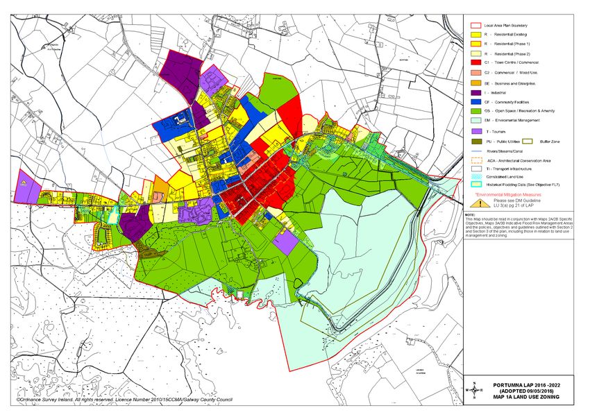
Table of Contents
                                                                                                                                                 Page

1.    Introduction .................................................................................................................................... 1

1.1     Preamble ....................................................................................................................................... 1
1.2     Profile of Portumna........................................................................................................................ 1
1.3     Local Area Plan ............................................................................................................................. 2
1.4     Plan Informants and Key Considerations ...................................................................................... 4

2.    Strategic Vision and Development Strategy ............................................................................... 7

2.1     Strategic Vision ............................................................................................................................. 7
2.2     Development Strategy ................................................................................................................... 8

3.    Development Policies, Objectives and Guidelines ................................................................... 13

3.1     Land Use Management ............................................................................................................... 13
3.2     Residential Development ............................................................................................................ 21
3.3     Social and Community Development .......................................................................................... 24
3.4     Economic Development .............................................................................................................. 26
3.5     Tourism ....................................................................................................................................... 29
3.6     Transportation Infrastructure ....................................................................................................... 31
3.7     Utilities Infrastructure, Climate Change and Environmental Management ................................. 36
3.8     Urban Design and Landscape ..................................................................................................... 49
3.9     Built Heritage and Cultural Heritage............................................................................................ 51
3.10 Natural Heritage and Biodiversity................................................................................................ 56

4.    Local Area Plan Maps .................................................................................................................. 62
1. Introduction
1.1 Preamble
This Local Area Plan is a land use plan and overall strategy for the development of Portumna covering
the period 2016 – 2022. This plan shall have effect from the date of adoption by the elected members
of Galway County Council and shall cease to have effect at the expiration of 6 years from that date,
unless the plan period is extended by resolution in accordance with Section 12 (d) to (f) of the Planning
and Development (Amendment) Act 2010. The successful implementation of the plan should have a
positive impact on Portumna, ensuring it develops in a sustainable manner and complements the
implementation of the current Galway County Development Plan 2015-2021.
1.2 Profile of Portumna
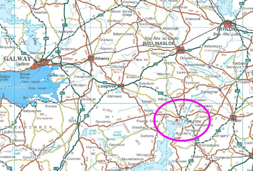
Portumna is located in south-east County Galway, approximately 68 kilometres south east of Galway
City, 31 kilometres south of Ballinasloe and 24 kilometres west of Birr. The town straddles the county
boundary with County Tipperary and it is recognised as the principle urban setting in south-east County
Galway serving an extensive rural hinterland on either side of the county divide. Portumna is served by
the National Secondary Road, the N65 and same acts as the main vehicular gateway to the town.
© Ordnance Survey Ireland. All rights reserved. Licence number
2010/15CCMA/Galway County Council.
Figure 1: Contextual Map of Portumna
Portumna derives its name from the Gaelic ‘Port Omna’ meaning the landing place of the oak tree and
it developed as a monastic settlement in the thirteenth century. The topography and natural features of
the area have also influenced the pattern and form of development in the town over the years. Portumna
is bounded by the River Shannon to the east, Lough Derg to the south and Portumna Forest Park to the
south-west. The Shannon forms a natural boundary between County Galway and County Tipperary and
it is prone to occasional flooding which is a constraint to development in some parts of the town. Lough
Derg is the largest lake on the river covering 32,000 acres, stretching approximately 32 miles in length
and 3 miles in width. Portumna Forest Park encompasses an area of approximately 600 hectares.
The Galway County Development Plan 2015 – 2021 identifies Portumna as a Key Town in the settlement
hierarchy for the county. This entails it functioning as a self sufficient service hub, offering a range
services including health, community, finance, employment, educational and retail provision to a broad
catchment population. A significant industry and large employer, Green Isle Foods, has recently
Page 1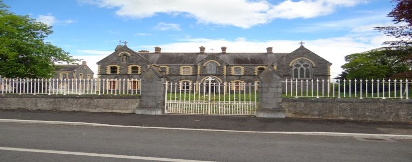
announced an expansion plan for its existing operation in the town that will result in additional
employment at the facility. Tourism represents a major asset to the town which can be enhanced upon
further in the future. Portumna is strategically positioned to benefit from boating and angling activity
associated with the Shannon waterway. Furthermore, there is scope to augment the heritage tourism
product emanating from Lough Derg, the Dominican Friary, Portumna Castle, Portumna Forest Park
and Portumna Union Workhouse for the betterment of the locality.

The population of Portumna has risen modestly in recent times. The town had 1,530 inhabitants in the
2011 Census, which was an 11% (153 persons) increase on the 2006 Census figure of 1,377
inhabitants. It is envisaged that the town will experience similar growth in the forthcoming plan period.
Therefore it is important to anticipate for same, by way of formulating a structured and proactive plan
that will enable the town to prosper in a sustainable manner.

1.3     Local Area Plan

1.3.1    Background to the Local Area Plan
This Local Area Plan has been prepared by Galway County Council to provide a statutory framework
for the future growth and development of Portumna. It is consistent with the policies and objectives
contained in the Galway County Development Plan, including the Core Strategy, and seeks to address
the needs and requirements of the local community, service providers and other stakeholders. The
purpose of the Local Area Plan is to guide future development within the town in a sustainable and
equitable manner and to inform members of the public, the local community, stakeholders and
developers, of the policies and objectives that will shape the development of the town over the next six
years. The policies and objectives for the development of the town include provisions in relation to land
use management, community facilities, amenities, transport, infrastructure, urban design, cultural/built
heritage, natural heritage and the environment.

The plan period is for 6 years, from the date of adoption by Galway County Council, unless the timeframe
is extended by resolution in accordance with Section 12(d) to (f) of the Planning and Development
(Amendment) Act 2010. The plan area is comprised of the town and its immediate environs and is
considered to provide an appropriate development envelope for the anticipated growth of the town for
the plan period.

1.3.2    Statutory Process
A Local Area Plan is prepared under the provisions of Sections 18, 19 & 20 of the Planning &
Development Act 2000 as amended. A Local Area Plan is statutorily required to be consistent with the
objectives of the current Galway County Development Plan and consists of a written statement and
plans which may include objectives for the zoning of land in accordance with the proper planning and
sustainable development of the area. The legislation also requires the provision of detail on community
facilities, amenities and detail on standards for the design of developments and structures.

Environmental assessments have also been undertaken to assess the potential impacts of the Local
Area Plan on the environment, including an Environmental Report (SEA/ER) and a Stage 2 Appropriate
Assessment (AA/NIR). The Environmental Report (ER) has been prepared in accordance with the EU
Directive on SEA (2001/42/EC), the national Strategic Environmental Assessment Regulations (SI No.
436 of 2004), (SI No. 200 of 2011), the 2004 Strategic Environmental Assessment Guidelines
Implementation of the SEA Directive (2001/42/EC): Assessment of the Effects of Certain Plans and
Programmes on the Environment issued by the Department of Environment, Heritage and Local
Government (DoEHLG) and regard has also being given to Circular PSSP 6/2011 ‘Further Transposition
of the EU Directive 2001/42/EC on Strategic Environmental Assessment (SEA). An Environmental
Report (ER) is required as part of the plan making process to assess the likely significant adverse effects
on the environment of implementing the Local Area Plan, before a decision is made to adopt it.

A Habitats Directive Assessment (also referred to as an ‘Appropriate Assessment’ or ‘AA’) has been
prepared in accordance with Article 6(3) of the EU Habitats Directive (92/43/EEC), European
Communities (Birds and Natural Habitats) Regulations 2011, the Appropriate Assessment of Plans and
Projects in Ireland-Guidance for Planning Authorities 2010 issued by the Department of Environment,
Heritage and Local Government and the Planning and Development Act 2000, (as amended). An

                                                                                                   Page 2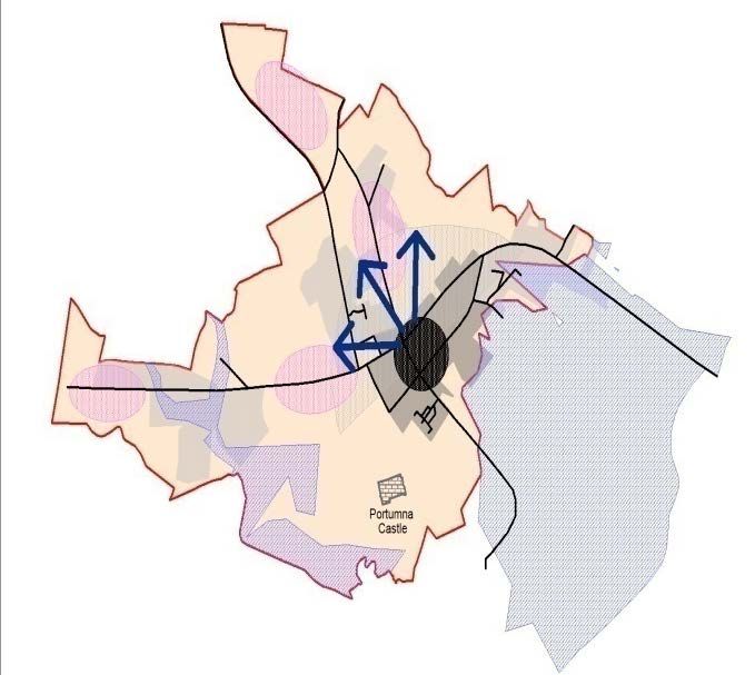
Appropriate Assessment is an assessment of the implications of the plan or project, alone and/or in
combination with other plans and projects, on the integrity of a Natura 2000 Site, in view of its
conservation objectives.
A Strategic Flood Risk Assessment has been prepared for County Galway, which broadly considers the
flood risk issues relevant to the plan area. The Strategic Flood Risk Assessment has been prepared in
accordance with the EU Floods Directive (2007/60/EC), the national European Communities
(Assessment and Management of Flood Risks) Regulations 2010 (SI No. 122 of 2010), the Planning
System and Flood Risk Management Guidelines for Planning Authorities 2009 issued by the DoEHLG
as updated by the Departmental Circular PL 2/2014 and identifies broad flood risk areas within Portumna
LAP area. A Stage 2 Strategic Flood Risk Assessment has also been undertaken for the plan area which
has identified flood zones and areas deemed to be at risk of flooding. The relevant flood risk data,
recommendations and mitigation measures from the Stage 2 Strategic Flood Risk Assessment (SFRA)
have been incorporated into the Local Area Plan, as appropriate.
1.3.3 Plan Structure
The Local Area Plan has been structured into 4 main sections as outlined below:
Introduction
• Preamble
Section 1 • Profile of Portumna
• Local Area Plan
• Plan Informants and Key Considerations
Strategic Vision and Development Strategy
Section 2 • Strategic Vision
• Development Strategy
Development Policies, Objectives and Guidelines
• Land Use Management
• Residential Development
• Social and Community Development
• Economic Development
Section 3 • Tourism
• Transportation Infrastructure
• Utilities, Climate Change and Environmental Management
• Urban Design and Landscape
• Built Heritage and Cultural Heritage
• Natural Heritage and Biodiversity
Local Area Plan Maps
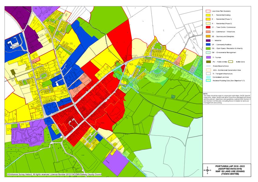
• Map 1A and 1B – Land Use Zoning
Section 4
• Map 2A and 2B – Specific Objectives
• Map 3 – Flood Risk Management
Supporting documents include a Stage 2 Appropriate Assessment (AA/NIR), an Environmental Report
(SEA/ER) and a Stage 2 Strategic Flood Risk Assessment (SFRA) for the LAP area, which are available
as separate documents to the Portumna Local Area Plan.
Page 3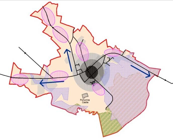
1.4   Plan Informants and Key Considerations

1.4.1 Plan Informants
The preparation of the Local Area Plan has been informed by a wide range of inputs, including the
following:

                                     Issues raised by the local community and other stakeholders
  Public Consultation                through the publication of the Background Issues Paper, draft
                                     public consultation and written submissions.
                                     All relevant Irish and European planning and environmental
                                     legislation, in particular the Planning and Development Act
                                     2000-2010, the Planning and Development Regulations 2001-
                                     2011; EU Directives, including the Birds Directive
                                     (2009/147/EEC), Habitats Directive (92/43/EEC), Water
  Legislative Context                Framework       Directive    (2000/60/EC),   SEA     Directive
                                     (2001/42/EC), the Floods Directive (2007/60/EC) and the EU
                                     Directive 2014/52/EU which amends Directive 2011/92/EU on
                                     the Assessment of the Effects of Certain Public and Private
                                     Projects on the Environment (EIA) and relevant associated
                                     regulations.
                                     National and regional policy documents and guidelines, in
                                     particular: Our Sustainable Future-A Framework for Sustainable
                                     Development for Ireland 2012, the National Development Plan
                                     2007-2013 as superseded by the Department of Public
                                     Expenditure and Reform document entitled “Infrastructure and
                                     Capital Investment 2012 – 2016”; the National Spatial Strategy
                                     2002-2022, the Regional Planning Guidelines for the West
                                     Region 2010-2022, the National Climate Change Strategy 2007-
                                     2012 and follow on document “National Climate Change
                                     Adaptation Framework, Buidling Resilience to Climate Change
                                     2012, Smarter Travel - A Sustainable Transport Future 2009-
  Strategic Planning Context         2020, and a range of guidelines including the Local Area Plan
                                     Guidelines (2013), SEA Guidelines 2004, Sustainable
                                     Residential Development in Urban Areas Guidelines 2009,
                                     Spatial Planning and National Roads – Guidelines for Planning
                                     Authorities (2012), The Planning System and Flood Risk
                                     Management Guidelines for Planning Authorities 2009 and
                                     Departmental Circular PL2/2014, Implementation of SEA
                                     Directive: Assessment of the Effects of Certain Plans and
                                     Programmes on the Environment Guidelines 2004, Appropriate
                                     Assessment of Plans and Projects in Ireland - Guidance for
                                     Planning Authorities 2010 and the Retail Planning-Guidelines
                                     for Planning Authorities 2012.
                                     Statutory plans, in particular the previous Local Area Plan for
                                     the town and the need for compliance and consistency with the
  Statutory Planning Context         current Galway County Development Plan and the Regional
                                     Planning Guidelines for the West Region 2010-2022.
                                     Local plans, strategies and studies, including: the Biodiversity
                                     Action Plan for County Galway 2008-2013; the Galway County
                                     Heritage Plan 2009-2014; Galway Transportation and Planning
  Local Planning Context             Study 2002; Developing Sustainable Tourism in Galway: A
                                     Framework for Action 2003-2012; Water-Based Tourism – A
                                     Strategic Vision for Galway 2002; and Working Together:

                                                                                             Page 4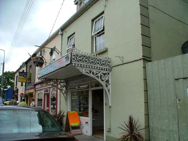
Shaping Our Future: Galway County Strategy for Economic,
                                       Social and Cultural Development 2002-2012 the Local
                                       Economic and Community Plan (LECP) for County Galway
                                       2014.

                                       Assessment of potential environmental impacts of the Local
  Environmental Assessment             Area Plan, including a Strategic Environmental Assessment,
                                       Appropriate Assessment and Strategic Flood Risk Assessment.

1.4.2 Plan Issues, Considerations and Challenges
The proper planning and sustainable development of Portumna encompasses a wide range of issues,
considerations and challenges, many of which have been highlighted through the consultation process.
The plan seeks to balance the wide ranging, and sometimes competing needs of the local community,
landowners and the environment, along with promoting the important role of Portumna within County
Galway. Some of the plans key issues, considerations and challenges are set out hereunder:

   •   Common Vision: A common strategic vision needs to be developed that provides a positive
       framework for future growth, consolidation and enhancement of the town in accordance with the
       principles of proper planning and sustainable development.

   •   Core Strategy: The Core Strategy in the Galway County Development Plan has identified a
       target population growth of up to 230 persons for Portumna through to 2021, which results in a
       requirement for 9.72ha of zoned land for residential purposes (based on 50% over-zoning). A
       key factor in the preparation of the Plan has been the determination of the best locations for
       residential land uses within the town to accommodate this future growth and to ensure
       residential development takes place in an orderly and sequential manner.

   •   Population Growth: Portumna has experienced a continued increase in population over recent
       Census periods. Ensuring sustainable settlement patterns, including the provision of the
       necessary planning framework, to accommodate educational, community, leisure and
       recreational facilities to satisfactorily match the level of population growth, is a key issue in
       planning for the future.

   •   Strategic Location: Portumna is located along the N65 National Secondary route in close
       proximity to the county boundary and interface with County Tipperary. The bridge is a strategic
       vehicular crossing point over the River Shannon and a gateway to the south east of County
       Galway. Furthermore, the town is recognised as a popular docking point for short stays by
       navigators awaiting a bridge swivel, prior to proceeding onwards with their boat journeys along
       the River Shannon.

   •   Infrastructure and Sustainable Transportation: Working towards ensuring that infrastructure
       is developed on an ongoing basis to service future developments in order to accommodate
       planned population growth, whilst ensuring compliance with the statutory obligations to achieve
       good water quality status under the EU Water Framework Directive and associated national
       legislation. Whilst the opportunities for public transport are limited in Portumna, there is scope
       to focus on promoting and facilitating the use of sustainable modes of transport, such as walking
       and cycling, in and around the town areas including in or near Portumna Castle and Demense
       and Portumna Forest Park. Facilitating bus service provision and associated facilities and
       reducing car dependency through integrated land use and transportation and wider Smarter
       Travel initiatives are also key considerations in the Local Area Plan process.

   •   Economic Activity and Tourism: Ensuring the enhancement of Portumna’s role as a centre
       for employment for residents of both the town and wider hinterland, through maximising the
       opportunity presented by its synonymous association with the River Shannon and its recognition
       as a gateway to south east County Galway. It is important to foster and maintain local and small
       scale businesses through protecting the vitality and vibrancy of the town centre, promoting and

                                                                                                 Page 5
facilitating appropriate tourism ventures, while ensuring that Portumna remains an attractive
    place to work, live, visit and do business.

•   Heritage and Environment: Promoting and facilitating appropriate growth of the town, while
    protecting the built, cultural and natural heritage of Portumna in accordance with applicable
    legislation and policy. This also includes consideration of the environmental designations
    adjacent to and within the plan boundary.

•   Flooding: Flood risk issues are an important consideration in the preparation of the Local Area
    Plan, particularly in zoning lands for appropriate uses in flood risk areas, and the Local Area
    Plan is guided by the Stage 2 Strategic Flood Risk Assessment for the Portumna LAP area
    which was carried out as part of the plan making process and aligns with the guidance contained
    within the document The Planning System and Flood Risk Management Guidelines for Planning
    Authorities Guidelines for Planning Authorities (2009), as updated and the DECLG Circular PL
    2/2014.

                                                                                           Page 6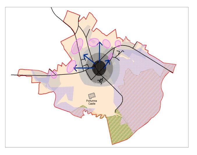
2.        Strategic Vision and Development Strategy

2.1       Strategic Vision

The plan is underpinned by a strategic vision. This is intended to guide the future growth and
development of Portumna in a sustainable manner, achieving the overall objectives set out for the town
in the Galway County Development Plan, in a way that reflects the existing character and amenity of the
area, the surrounding landscape, heritage, environment and improves the quality of life of residents and
the local community.

The strategic vision is informed by guiding principles that will enable the overall vision to be achieved,
these include:

      •    Realising the town’s potential as one of the ‘Key Towns’ as set out in the Galway County
           Development Plan and attracting the population target established in the Core Strategy up to
           2021 and beyond.

      •    Acknowledging that the medium term growth of Portumna should focus on new sustainable
           communities and adopt a sequential approach to the zoning of residential lands extending
           outwards from the centre of the town in line with the Guidelines for Planning Authorities –
           Sustainable Residential Development in Urban Areas (Cities, Towns and Villages) (2009).

      •    Reflecting the needs and aspirations of local communities, business and other interested and
           affected groups, as expressed through the public consultation process.

      •    Promoting sustainable land use and transport by capitalising on the opportunity presented by
           the potential to develop walking and cycling opportunities within the town focused around the
           forest and the river, so that sustainable travel such as walking, cycling and other smarter travel
           initiatives, along with integrated land use and transportation become central to the development
           of new neighbourhoods and the future development of Portumna.

      •    Maintaining and promoting a strong and vibrant town centre which sustains the ability to attract
           new businesses and meets the retailing and service needs of the town and its surrounding
           hinterland, in addition to offering a pleasant and attractive environment for shopping, business,
           tourism, recreation and living.

      •    Ensuring that there are a range of facilities, amenities and supporting services including
           educational, recreational, religious, social, community and civic requirements for children,
           youths, adults and the elderly, to serve a growing community.

      •    Optimising the potential of the town’s strategic location, in close proximity to the River Shannon
           and as a service hub to an extensive rural hinterland, through facilitating and fostering
           appropriate tourism and economic development, through setting a positive and flexible
           framework, which enhances Portumna as a place for tourism and employment opportunities.

      •    Supporting the delivery of the necessary infrastructure to facilitate the future growth and
           sustainable development of the town.

      •    Protecting the natural assets, environment, built heritage and public realm of the town, including
           its local character for the benefit of future generations to come.

      •    Promoting a strong sense of community spirit, civic pride, local identity and social inclusiveness
           in the locality and establishing a strong local identity that is distinguishable from other areas.

                                                                                                     Page 7
Vision Statement
“To promote Portumna as a sustainable, self-sufficient and vibrant town, which maintains its unique
character, capitalises on its existing cultural and tourism assets, while offering a pleasant environment
for a growing community, for living, shopping, for education, business and recreation. This requires
there to be a degree of balance whereby the environmental sensitivities of the area and Portumna
Castle and Demense, Portumna Forest Park and Lough Derg in particular are safeguarded, for present
and future generations to come”.
2.2 Development Strategy
2.2.1 Core Strategy Context
A Core Strategy is required under the Planning and Development Act 2000 (as amended) to ensure that
the development objectives of Development Plans/Local Area Plans are consistent, as far as
practicable, with national and regional development objectives set out in the National Spatial Strategy
2002-2020 and with the West Regional Planning Guidelines 2010-2022. Based on the population targets
outlined in the Regional Planning Guidelines, the Galway County Development Plan identifies a
population target of 13,160 for the County (not including Galway City) by 2021.
The Core Strategy details the allocation of this county population target within County Galway, the Tuam
hub, the County town of Ballinasloe, Key Towns/Other Towns, Other Villages and Other Settlements
including Rural Areas up to 2021. Portumna as one of the ‘Key Towns/Other Towns’ within the Core
Strategy/Settlement Strategy, seeks to augment its important position as key service centre and driver
of growth for the town and its surrounding environs.
A key component of the Portumna Local Area Plan 2016 - 2022 is to ensure that it aligns with the Core
Strategy/Settlement Strategy as set out in the Galway County Development Plan. The Core Strategy
indicates that Portumna has been assigned a population growth target of 230 persons by 2021 with a
housing land requirement of 9.72ha (which includes a permitted 50% over provision) in order to
accommodate residential development over the plan period. The plan must therefore consider the most
appropriate residential options such as phasing, rezoning and de-zoning in order not to exceed the
maximum requirements of the 9.72ha from the Core Strategy and to ensure that suitable lands are
brought forward for development during the plan period.
2.2.2 Development Options
In order to achieve the strategic vision for Portumna, it is important to examine a number of Development
Strategy Options to ascertain which option can deliver most effectively on the vision for the town.
Continuing on with the previous plan is not considered an appropriate approach as it would not take
account of advances in planning guidance, best practice or recent changes to legislation or E.U.
Directives. Such an approach would also conflict with the Regional Planning Guidelines and the Core
Strategy of the Galway County Development Plan and therefore would not be in accordance with the
proper planning and sustainable development of the town.
A number of potential development options have been considered hereunder. These options have been
conceptualised having regard to a number of considerations including the Core Strategy, the settlement
hierarchy, the role of the town as envisaged in the Galway County Development Plan, population and
growth trends, the potential of the town, the existing development pattern and character of the town, the
existing amenities and environmental sensitivities and the lands and services available for future
development.
These strategic options and maps as described and illustrated overleaf are indicative and for
presentation purposes only.
Page 8Development Strategy Options
Development Option 1 – Concentrated Development to the North-West of the Plan Area.
Option 1 provides for a scenario whereby all
future development will refrain from interfering
directly or occurring immediately adjacent to
environmental designations and sensitivities that
traverse the existing town plan boundary to the
south and south east. Furthermore, the pursuance
of this development approach would entail the
removal of certain segments of the affected lands
from the confines of the town boundary and the
replacement of same with segments of land to the
north and west. This option would limit the
expansion of the town considerably, and would
not take cognisance of the existing established
development that has taken place to the south
east of the town.
Development Option 2 – Urban Sprawl on the Arterial Routes of the Plan Area
Option 2 provides for a scenario whereby all new
development has the potential to materialise on
spacious sites with an abundance of amenity
space outwards along the arterial routes serving
the town. This would likely constitute urban sprawl
and displace development growth outwards and
further away from the existing town centre to
locations removed from the employment bases,
school sites and general services within the town
core, making it more difficult to encourage
balanced and integrated development within the
town.
Development Option 3 – Consolidate Town Expansion & Promote Sequential Development with
a Refined Plan Boundary
Option 3 seeks to consolidate the existing town
centre, promote sequential development around
the town core and avoid disorderly development
on the periphery. In this scenario, future
residential growth would be encouraged in a
sequential manner from the town centre outwards,
in order to maximise a return on investment in
services and to ensure the availability of optimal,
serviced lands to accommodate anticipated
growth. Reducing the area of the plan provides an
opportunity to focus development on integrating
into and establishing connectivity to the town core.
This would be a sustainable approach and assist
in minimising the impact of climate change, while
taking account of environmental considerations.
Page 92.2.3 Preferred Development Option
After an assessment of the development options presented, Option 3 is considered the preferred
Development Option.
This option includes a refined plan boundary, providing a more appropriate development envelope and
greater certainty to the future growth of the town, including rationalised land use zonings to align with
the Core Strategy. It also takes account of the infrastructural capacity within the town, with particular
regard to water and wastewater availability and takes cognisance of flood risk areas.
This approach supports the consolidation of development within the plan area, supports sequential
development of the remainder of the urban core from the centre outwards and ensures that serviced,
residential lands close to the town centre are the primary focus for development in the short to medium
term. This in turn will encourage reduced travel demands, more sustainable transport options and ease
of access to community facilities, employment resources and retail and service provision within the town.
Retail in the town is one of the main sources of employment for the area and it is imperative that this
employment base is maintained and strengthened. Appropriately scaled retail in the right location,
including the development of brownfield and under-utilised sites in the town centre will ensure buoyancy,
aid town centre vitality and viability and assist in reducing retail vacancy levels. The recent opening of a
large scale retail complex westwards of the centre has the potential to significantly alter the retail
dynamic of the settlement. Therefore going forward it is important to ensure balanced retail provision
within the town centre so as to avoid there being displacement in this regard.
Portumna has a limited industrial and enterprise base and this development option seeks to provide the
planning framework to strengthen employment prospects through the land use zoning provisions and
the policies and objectives set out within the plan. In addition, the tourism aspects of the town remains
largely undeveloped, which also presents a significant opportunity to expand and promote the tourism
base of the area, particularly given Portumna’s close proximity to the River Shannon and heritage sites
such as nearby Lough Derg.
Portumna has an adequate provision of community facilities including schools, a library and a number
of sport pitches, which are dispersed around the town, allowing the opportunity for shared use of such
facilities. In planning for the requirements of a growing town, it is important to ensure that there are
adequate lands available in these areas to allow for the expansion of these facilities to meet the future
demands as the town develops.
This development option also takes account of the necessary environmental considerations for
Portumna. A Stage 2 Strategic Flood Risk Assessment was carried out in tandem with the preparation
of the Local Area Plan which informs future land uses including the avoidance of flood risk areas and
the inappropriate development of same. Green infrastructure and climate change were also keys
elements for consideration in the preparation of this Local Area Plan.
The built heritage, including recorded monuments, National Monuments, structures on the Record of
Protected Structures, the designated Architectural Heritage Area and buildings of vernacular interest
within Portumna are important attributes of the town and the preferred development option will ensure
these elements are afforded the necessary protection. Similarly, the natural heritage and biodiversity of
Portumna are important features which contribute to the character of the area and also need to be
safeguarded under the preferred development option.
Finally, this preferred Development Strategy Option is informed by the statutorily required environmental
assessment and seeks to enhance sustainability, promote economic and social development and
ensure quality of life and the protection of the environment. It also aligns with and aims to deliver on the
Core Strategy requirements set out for Portumna in the Galway County Development Plan and supports
the objectives of the Regional Planning Guidelines to provide for the sustainable, dynamic development
of towns to a level that can deliver the conditions for balanced regional development.
2.2.4 Land Use Management and Zoning
In order to deliver on this preferred Development Strategy, a number of scenarios have been considered
in relation to land use management and zoning:
Page 101. Re-zoning of lands.
2. Phasing of development on lands zoned for residential uses.
3. De-zoning of lands.
The rationalising of the plan boundary, the phasing of residential development and the rezoning of
certain lands for environmental reasons is considered the most appropriate approach at this time.
Residential lands have generally been phased in a sequential manner, with Phase 1 residential lands
identified for short to medium term growth in suitable locations that are serviceable and accessible.
These lands include infill sites, sequential extensions to the existing residential fabric and growth areas
predominantly to the north of the Plan Area. The phasing as applied allows for some flexibility, as
detailed by the policies and objectives in the plan, while adhering to the Core Strategy.
In general, green field/undeveloped lands located within identified flood risk areas (in particular
Indicative Flood Zone A and B) have been rezoned as ‘Open Space/Recreation and Amenity’ in
accordance with the Flood Risk Management Guidelines 2009, in order to avoid inappropriate
development in high to moderate flood risk areas and to address the potential impacts of climate change.
Lands at the fringes of the Plan Area that are located within the European designated environmental
sites i.e. the Special Areas of Conservation and Special Protections Area have all been zoned for
Environmental Management, while lands that are located within the proposed Natural Heritage Areas,
Portumna Forest Park and the grounds of Portumna Castle have been zoned Open Space/Recreation
and Amenity.
Large scale employment uses are focussed in the west and north area of the plan on Industrial, and
Enterprise zonings. The town centre area remains the primary target for the location of new retail
development, with opportunities to develop this sector in a consolidated and sequential manner. In
addition, the land use zoning matrix provides further guidance on appropriate uses in the various zones.
Overall this is considered to be the most appropriate option at this time for securing the orderly and
sequential development of Portumna.
2.2.5 Compliance with the Galway County Development Plan
The Portumna Local Area Plan sets out the overall development strategy, planning policies and
objectives for the plan for the period from 2016 - 2022, which seeks to provide for the medium term
planning and development benefit for Portumna as one of the ‘Key Towns’ identified in the Settlement
Strategy and Core Strategy of the Galway County Development Plan. The Plan continues to support the
important economic, education, service and community role and function in line with the broad planning
principles outlined in the National Spatial Strategy, the Regional Planning Guidelines for the West
Region and the Galway County Development Plan. Population targets and the Core Strategy residential
land area allocations for Portumna have been aligned in accordance with these overarching plans. The
plan’s policies, objectives, and development management guidelines and standards have also been
informed by best practices, national planning guidance and the Galway County Development Plan,
where appropriate. The SEA and AA and the SFRA have also informed the preparation of the Local
Area Plan.
National
Galway
Spatial Regional Portumna
County
Strategy & Planning Local Area
Development
National Guidelines Plan
Plan
Policy
Page 112.2.6 Policy and Objectives
Development Strategy Policy
Policy DS 1 – Development Strategy
It is the overarching policy of Galway County Council to support and facilitate the sustainable
development of the plan area in line with the preferred development strategy option, Option 3 -
Consolidate Town Expansion & Promote Sequential Development with a Refined Plan
Boundary which allows Portumna to develop in a manner, that maintains and enhances the quality
of life of local communities, promotes opportunities for economic development, sustainable transport
options and social integration, connectivity and social integration, protects the cultural, built, natural
heritage and environment and complies with relevant statutory requirements.
Development Strategy Objectives
Objective DS 1 – Orderly and Sequential Development
Support the orderly and sequential development of the plan area, focussing on the consolidation and
continued vitality and viability of the town centre and the protection and enhancement of the existing
landscape setting, character and unique identity of the town.
Objective DS 2 – Consistency with Core Strategy
(Refer to the Galway County Development Plan)
Galway County Council will ensure that developments permitted within the plan area are consistent
with the zoned land allocations in the Core Strategy and associated provisions in the Galway County
Development Plan.
Objective DS 3 – European Sites
Protect European sites that form part of the Natura 2000 network (including Special Protection Areas
and Special Areas of Conservation) in accordance with the requirements in the EU Habitats Directive
(92/43/EEC), EU Birds Directive (2009/147/EC), the Planning and Development (Amendment) Act
2010, the European Communities (Birds and Natural Habitats) Regulations 2011 (SI No. 477 of 2011)
(and any subsequent amendments or updated legislation) and having due regard to the guidance in
the Appropriate Assessment Guidelines 2010 (and any updated/superseding guidance). A plan or
project (e.g. proposed development) within the plan area will only be authorised after the competent
authority (Galway County Council) has ascertained, based on scientific evidence, screening for
Appropriate Assessment, and a full Appropriate Assessment where necessary, that:
1. The plan or project will not give rise to significant adverse direct, indirect or secondary effects on
the integrity of any European site (either individually or in combination with other plans or
projects); or where
2. The plan or project will adversely affect the integrity of any European site (that does not host a
priority natural habitat type and/or a priority species) but there are no alternative solutions and
the plan or project must nevertheless be carried out for imperative reasons of overriding public
interest, including those of a social or economic nature. In this case, it will be a requirement to
follow procedures set out in legislation and agree and undertake all compensatory measures
necessary to ensure the protection of the overall coherence of Natura 2000; or where
3. The plan or project will adversely affect the integrity of any European site (that hosts a priority
natural habitat type and/or a priority species) but there are no alternative solutions and the plan
or project must nevertheless be carried out for imperative reasons of overriding public interest,
restricted to reasons of human health or public safety, to beneficial consequences of primary
importance for the environment or, further to an opinion from the Commission, to other imperative
reasons of overriding public interest. In this case, it will be a requirement to follow procedures
set out in legislation and agree and undertake all compensatory measures necessary to ensure
the protection of the overall coherence of Natura 2000.
Page 12Objective DS 4 – Development Management Standards and Guidelines
The general development management standards and guidelines set out under the current Galway
County Development Plan, or any subsequent variation/review, shall apply as appropriate in the plan
area. In addition, any specific development management guidelines set out in Section 3 of this plan
shall also be applied, as appropriate, to development proposals in the plan area.
Objective DS 5 – Service Led Development
Development under the plan shall be preceded by sufficient capacity in the public waste water
infrastructure and potable water infrastructure.
Objective DS 6 – Residential Development Phasing
Direct residential development into appropriately zoned and serviced areas in accordance with the
phased development framework set out in Sections 3.1 and 3.2 and on Maps 1A/1B - Land Use
Zoning.
Objective DS 7 – Flood Risk Management and Assessment (Refer to Map 3)
Ensure that proposals for new developments located within identified or potential flood risk areas, or
which may exacerbate the risk of flooding elsewhere, are assessed in accordance with the provisions
of The Planning System and Flood Risk Management Guidelines for Planning Authorities 2009 (or
as updated) and Departmental Circular PL2/2014 and the relevant policies and objectives of this
plan.
Objective DS 8 – Climate Change and Adaptation
Galway County Council shall support the National Climate Change Strategy and follow on document
the National Climate Change Adaptation Framework Building Resilience to Climate Change 2012 (or
any updated/superceding document) including the transition to a low carbon future, taking account
of flood risk, soil erosion, the promotion of sustainable transport, improved air quality, the importance
of biodiversity and green infrastructure, the use of renewable resources and the reuse of existing
resources.
Objective DS 9 – Screening for Appropriate Assessment
It is an objective of Galway County Council to ensure that Appropriate Assessment Screening and
Appropriate Assessment, if required, is undertaken in view of the Conservation Objectives of the
European sites that may be affected by the policies and objectives of the plan and that:
a) The AA process will be a scientific assessment that will present relevant evidence where required,
including data and analysis as available from the most up to date Article 17 reports on the
conservation status of the natural habitats and species in the Habitat Directive Annexes and the most
up to date Article 12 reports on status and trends of bird species, in addition to, data on ecological
features in or near the Plan area available from other sources e.g. National Biodiversity Data Centre,
BirdWatch Ireland, Bat Conservation Ireland and other sources as appropriate.
b) Similarly that all habitats and species protected by Article 10 of the Habitats Directive and any
other sites that may be considered as stepping stones in support of the European sites will be
addressed as part of the AA process.
Objective DS 10 – Future Developments and EU Directives
Ensure that all future developments within the plan area fully take into account the requirements of
the Environmental Impact Assessment, Habitats, Birds, Water Framework and Floods Directives
respectively, as relevant and appropriate.
3. Development Policies, Objectives and Guidelines
3.1 Land Use Management
3.1.1 Context
The Core Strategy of the current Galway County Development Plan sets the context and parameters
for the development of Portumna as one of the ‘Key Towns’ identified in the county. Based on population
projections derived from the population targets set out in the Regional Planning Guidelines for the West
Page 13Region 2012-2022, the amount of zoned residential land required to facilitate this target is set at 9.72ha
for the time period up to 2021. Lands have also been zoned for other land uses in the plan, including
town centre/commercial, business/enterprise, industry, tourism, community facilities and open
space/recreation uses. These are based on Portumna’s role in the Core Strategy/Settlement Strategy,
existing land use patterns, and projected needs derived from medium and long term population targets.
The optimum utilisation of existing and planned infrastructure is also a key consideration in the
development of this land use framework.
3.1.2 Policies and Objectives
Land Use Management Policy
Policy LU 1 – Land Use Management
It is the policy of Galway County Council to provide a land use zoning framework for the plan area, to
direct the type, density and location of development in a manner that contributes to the consolidation
of the town centre and that complies with the statutory requirements of the Planning and Development
Acts 2000 (as amended). The land use zoning framework is supported by a residential phasing scheme
to ensure compliance with the Core Strategy and to promote the orderly and sequential development
of the town.
Land Use Zoning Objectives
Objective LU 1 – Town Centre/Commercial (C1) (Refer to Maps 1A/1B)
Promote the sustainable development of the Town Centre as an intensive, well connected, high quality,
well-landscaped, human-scaled and accessible environment, with an appropriate mix of uses,
including residential, commercial, service, tourism, enterprise, public and community uses as
appropriate, that provides a range of retail services, facilities and amenities to the local community and
visitors to the town. The town centre and associated main streets shall remain the primary focus for
retail and service activity within Portumna.
Objective LU 2 – Commercial/Mixed Use (C2) (Refer to Maps 1A/1B)
Promote the sustainable development of commercial and complementary mixed uses, on suitable
lands that can provide focal points for the provision of services to surrounding neighbourhoods/areas
and opportunities for commercial enterprises, retail developments and employment creation and which
do not undermine the vitality and viability of the town centre.
Objective LU 3 – Residential (R) (Refer to Maps 1A/1B and Objective RD1)
Promote a phased, sequential approach on Residential zoned lands, with a strong emphasis on
consolidating existing patterns of development, encouraging infill opportunities and promoting
sustainable transport options.
It is an objective to:
(a) Promote the development of appropriate and serviced lands to provide for high quality, well
connected and well laid out and landscaped sustainable residential communities with an appropriate
mix of housing types and densities, together with complementary land uses such as community
facilities, and sustainable transport options to serve the residential population of the area and the
surrounding environment.
(b) Protect existing residential amenities and facilitate compatible and appropriately designed new infill
development, in accordance with the proper planning and sustainable development of the area.
A Phasing Scheme shall apply to residential uses on Residential (R) zoned lands, as set out under
Objective RD1 in Section 3.2.2.
Objective LU 4 – Industrial (I) (Refer to Maps 1A/1B)
Promote the sustainable development of industrial and industrial related uses, including manufacturing,
processing of materials, warehousing and distribution on suitable lands, with adequate services and
facilities and a high level of access to the major road networks and public transport facilities.
Adequate perimeter treatment and/or screening will be required to ensure high quality interfaces with
public spaces and any adjoining residential areas or other sensitive land uses, as appropriate.
Page 14Objective LU 5 – Business and Enterprise (BE) (Refer to Maps 1A/1B)
Promote the sustainable development of business and enterprise uses, light industry/warehousing and
the facilitation of enterprise park/office park type uses, incubation/start-up units and Small Medium
Enterprises, on suitable lands with adequate services and facilities and with a high level of access to
the major road networks and to public transport facilities.
Objective LU 6 – Community Facilities (CF) (Refer to Maps 1A/1B)
Promote the sustainable development of community facilities on suitable lands, with a high level of
access to the local community, including educational, community, civic, public, institutional,
recreational, cultural and other complementary uses, as appropriate.
Objective LU 7 – Tourism (T) (Refer to Maps 1A/1B)
Promote Portumna as a premier tourist destination in its own right and as a tourism hub for the south
east of the county, offering a high quality, rich and diverse experience to all visitors.
Objective LU 8 – Open Spaces/Recreation and Amenity (OS)
(Refer to Objective DS 9 and Maps 1A/1B)
Promote the sustainable management, use and/or development, as appropriate, of the OS lands. This
will include the:
a) Development of open spaces and recreational activities, in accordance with best practice and on
suitable lands with adequate access to the local community and retain existing open space and
recreational facilities, unless it can be clearly demonstrated to the satisfaction of Galway County
Council that these uses are no longer required by the community.
b) Appropriate management and use of any flood risk areas within the OS Zone to avoid, reduce and/or
mitigate, as appropriate, the risk and potential impact of flooding.
Objective LU 9 – Constrained Land Use Zone (CL) (Refer to Objective DS 9 also)
To facilitate the appropriate management and sustainable use of flood risk areas.
This zoning limits new development, while recognising that existing development uses within these
zones may require small scale development, as outlined below, over the life of the Local Area Plan,
which would contribute towards the compact and sustainable urban development of the town.
The underlying zoning or the existing permitted uses are deemed to be acceptable in principle for
minor developments to existing buildings (such as small extensions to houses, most changes of use
of existing buildings), which are unlikely to raise significant flooding issues, provided they do not
obstruct important flow paths, introduce a significant additional number of people into flood risk areas
or entail the storage of hazardous substances.
Development proposals within this zone shall be accompanied by a detailed Flood Risk Assessment,
carried out in accordance with The Planning System and Flood Risk Assessment Guidelines and
Circular PL 2/2014 (or as updated), which shall assess the risks of flooding associated with the
proposed development.
Proposals shall only be considered where it is demonstrated to the satisfaction of the Planning
Authority that they would not have adverse impacts or impede access to a watercourse, floodplain or
flood protection and management facilities, or increase the risk of flooding to other locations. The
nature and design of structural and non-structural flood risk management measures required for
development in such areas will also be required to be demonstrated, so as to ensure that flood hazard
and risk will not be increased. Measures proposed shall follow best practice in the management of
health and safety for users and residents of the development.
Specifications for developments in flood vulnerable areas set out in this plan shall be complied with
as appropriate. (Please also refer to Objective FL3 and DM Guideline FL 2)
Objective LU 10 – Environmental Management (EM) (Refer to Maps 1A/1B)
Protect lands and sites with high biodiversity value and/or environmental sensitivity and promote their
sustainable management and use. This will include the protection of the integrity of European sites
Page 15that form part of the Natura 2000 network, in particular Special Areas of Conservation, in accordance
with the conservation management objectives of these sites and the requirements of the EU Habitats
Directive (92/43/EEC).
Objective LU 11 – Public Utilities (PU) (Refer to Maps 1A/1B)
Facilitate the provision and maintenance of essential public utility infrastructure, together with
necessary ancillary facilities and uses, as appropriate.
Objective LU 12 – Transport Infrastructure (TI) (Refer to Maps 1A/1B)
Facilitate the provision and maintenance of essential transportation infrastructure. This shall include
the reservation of lands to facilitate public roads, footpaths, harbours, canals, cycle ways, bus stops
and landscaping, together with any necessary associated works, as appropriate.
Objective LU 13 – Flood Risk Areas and Land Use Zones (Refer to Maps 1A/1B and Map 3)
Ensure that any proposed development that may be compatible with the land use zoning
objectives/matrix but which includes a use that is not appropriate to the Flood Zone (as indicated on
Map 3– Flood Risk Management) and/or that may be vulnerable to flooding is subject to flood risk
assessment, in accordance with The Planning System and Flood Risk Management Guidelines for
Planning Authorities 2009 and the Departmental Circular PL 2/2014 (or as updated within the lifetime
of this plan) and the policies and objectives of this plan.
Objective LU 14 – Land Use Zoning Matrix (Refer to DM Guideline LU 2)
Direct different land uses into the appropriate land use zone(s) in accordance with the land use zoning
objectives and the land use zoning matrix set out under DM Guideline LU2. Ensure that proposed
land uses are compatible with existing land uses and in keeping with the character of the area.
Land Use Density Objectives
Objective LU15 – Development Densities
Ensure that the density of new development is appropriate to the land use zone and site context, is in
keeping with the development pattern of the area, does not unduly impact on the amenities of the area
and that it results in a positive relationship between existing developments and any adjoining public
spaces. The development of higher density development shall be promoted in appropriate locations,
such as suitable sites within the town centre and adjacent to public transport facilities, where such
development is compatible with the built and natural heritage, urban design objectives, infrastructure
capacity and environmental considerations. The density of developments will generally be in
accordance with the guidance set out under DM Guideline LU1, although the Planning Authority may
consider higher density developments where this is considered appropriate to secure the urban design
or other objectives of the plan.
Objective LU 16 – Residential Densities
Promote a range of residential densities within the plan area appropriate to the prevailing development
pattern, supporting infrastructure, urban character and heritage resources in accordance with the
guidance in Sustainable Residential Development in Urban Areas Guidelines 2009 (or as updated
within the lifetime of this plan). Higher residential densities should be encouraged at locations where it
is appropriate to the existing context and density of the plan area, for example around the town centre
and within convenient walking distance of public transport facilities, and where it will not unduly impact
on built or natural heritage or impact adversely on the integrity of European sites. The density of
residential developments will generally be in accordance with the guidance set out under DM
Guideline LU1, although the Planning Authority may consider higher residential densities where this
is considered appropriate to the context and necessary to secure the urban design or other objectives
of the plan. Development will only be permitted where there is capacity and/or adequate services can
be made available.
Page 16You can also read