City of September 2019 - City of Napoleon, Ohio
←
→
Page content transcription
If your browser does not render page correctly, please read the page content below
City of
     Napoleon

    MASTER
     PLAN

    September 2019

*
City of Napoleon Master Plan

Table of Contents

     Acknowledgements ........................................................................................................................... ii                 Planning Area Issues and Recommendations ............................................................................. 29
   Executive Summary .................................................................................................................... 1                            Map: Planning Areas ........................................................................................................................ 31
    Plan Themes and Initiatives ............................................................................................................... 2                      1) US 24 Commerce Planning Area ............................................................................................. 32
   Public Participation ..................................................................................................................... 4                        2) Oakwood Planning Area .......................................................................................................... 35
    Department / Staff Meetings............................................................................................................. 5                         3) Scott Street Planning Area ...................................................................................................... 37
    Stakeholder Interviews ...................................................................................................................... 5                    4) Glenwood Planning Area ......................................................................................................... 40
    Community Survey ............................................................................................................................. 5                   5) South River Planning Area ....................................................................................................... 43
    Community Forum ............................................................................................................................. 7                    6) Downtown Planning Area ....................................................................................................... 45
                                                                                                                                                                       Map: Downtown Planning Area ...................................................................................................... 48
   Planning Conditions .................................................................................................................... 8                          Map: Land Use Diagram – Riverfront Target Area .......................................................................... 49
     Demographic Trends ........................................................................................................................10
     Environmental Considerations ........................................................................................................13                         General Recommendations ....................................................................................................... 50
     Map: Environmental Conditions ......................................................................................................14                           Connectivity Solutions ..................................................................................................................... 51
     Economic Development ...................................................................................................................15                       Map: Planned / Proposed Pedestrian Connectivity Improvements ............................................... 54
     Map: Economic Incentive Areas ......................................................................................................16                           Map: Planned / Proposed Thoroughfare Improvements ................................................................ 55
     Existing Land Use and Zoning ..........................................................................................................17                        Community Growth / Revitalization Solutions ................................................................................ 56
     Map: Existing Land Use ....................................................................................................................19                    Utility Solutions................................................................................................................................ 59
     Map: Zoning .....................................................................................................................................21              Quality of Life Solutions................................................................................................................... 62
     Parks and Recreation .......................................................................................................................22                   Land Use and Zoning Solutions ....................................................................................................... 64
     Infrastructure ...................................................................................................................................23             Future Land Use Plan ....................................................................................................................... 67
     Safety Services .................................................................................................................................28              Map: Future Land Use ..................................................................................................................... 69
                                                                                                                                                                     Plan Implementation ................................................................................................................. 70
                                                                                                                                                                       How to Use the Plan ........................................................................................................................ 71
                                                                                                                                                                       Plan Implementation Table ............................................................................................................. 72

                                                                                                                                                            Page i
                                                                                                                                                Table of Contents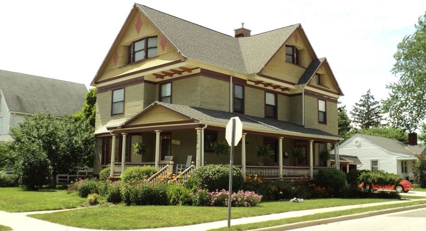
City of Napoleon Master Plan
Acknowledgements
                                                                                                             This document was also prepared with the information gathered from numerous public and private
The 2019 City of Napoleon Master Plan was developed under the guidance of department heads,
                                                                                                             organizations.
stakeholders and elected officials comprised of the following individuals:

                                                                                                             Consulting Team
Elected Officials       Council Member
Jason P. Maassel        Mayor of the City of Napoleon

Daniel Baer             Councilperson – Chairperson of the Safety & Human Resources

Joseph Bialorucki       Council President – Chairperson of the Finance & Budget Committee

Jeffrey Comadoll        Councilperson – Chairperson of the Water/Sewer Committee
                        Councilperson – Chairperson of the Technology & Communication
Ken Haase
                        Committee
Jeff Mires              Councilperson – Chairperson of the Parks and Recreation Committee

Travis Sheaffer         Councilperson – Chairperson of the Electric Committee
                        Councilperson – Chairperson of the Municipal Properties, Building, Land
Lori Siclair
                        Use and Economic Development Committee

Department Personnel Department/Agency
Joel Mazur              City Manager

Kent Seemann            Finance Director

Billy D. Harmon         Law Director

Chad Lulfs, PE, PS      Public Works & Engineering Department

David Mack              Police Department Chief

Clayton O'Brien         Fire & Rescue Department Chief

Tony Cotter             Parks & Recreation Department

Dr. Steve Fogo          Napoleon Area School District

Betsy Eggers            Napoleon Public Library

Mary Hoeffel            Napoleon Alive, Inc.

                                                                                                   Page ii
                                                                                              Acknowledgements
“I believe the City of Napoleon needs to decide if we want to continue to lose residents to other areas in NW Ohio
 or whether we need to work with developers to give them breaks in building costs in the beginning and be more
                      accommodating before Napoleon turns into another “dying” community.
         Napoleon could be a great bedroom community to the Waterville/Perrysburg/Whitehouse areas,
                               but have no housing, decent restaurants or shopping.
                                                                                               ~Survey Respondent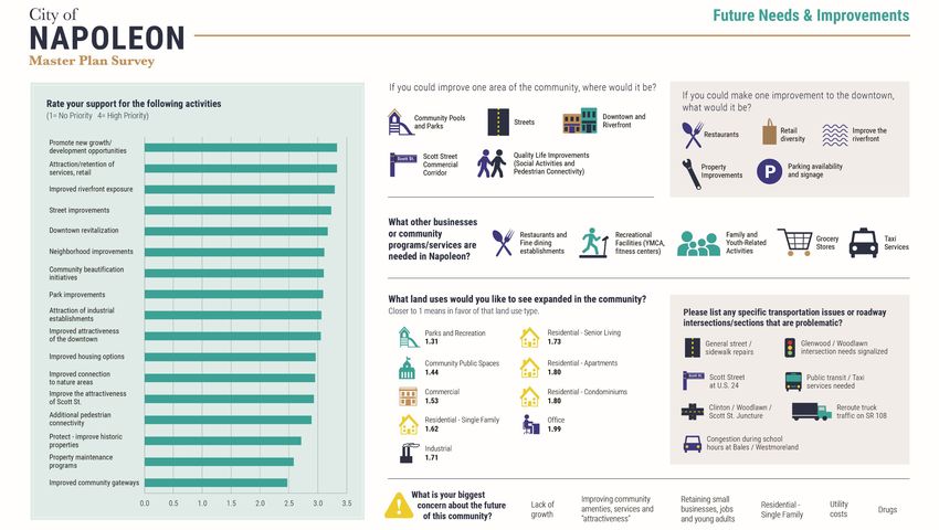
City of Napoleon Master Plan
Executive Summary community. To help offset this trend, City officials are desirous
Improve the Riverfront of working to unlock new areas of Napoleon for growth
This Master Plan is the City of Napoleon’s (the City) official opportunities.
As one of the prime assets of Henry County,
document that outlines a plan of action to implement strategies
the river traverses the community’s
in several areas such as land use, riverfront and economic According to current demographic trends, the City’s population
downtown with uninspiring human
development, connectivity, neighborhood revitalization and is aging, yet there are limited newer housing opportunities for
connection, and remains vastly underutilized.
quality of life. It integrates the ideas presented by over 600 seniors. The future of tomorrow’s workforce is dependent upon
The closure of Central Elementary School and the potential
residents that participated in this effort. young professionals, yet the City’s housing market offers few
adaptive reuse of selected properties could provide an
updated housing opportunities for this particular group. Efforts
opportunity to stimulate linkages and land uses that are socially
The Plan has several roles in shaping the community’s quality of are underway, however, by local and regional developers to help
and economically profitable.
life, by acting as: meet these needs.
A reference guide used by City officials, department The recent improvements in the downtown such as the
Many promising areas designated for residential, commercial, or
heads, residents, and local and national investors to sidewalks and outdoor dining and refreshment areas, along with
mixed uses are located west of Scott Street and in Northpoint
coordinate efforts to improve the City’s physical and private sector investments have helped to bring refreshing
Business Park along US 24. The potential construction of a new
social environments improvements to both the downtown and riverfront. Based on
river bridge could link Napoleon's two separate industrial areas
A scorecard of community progress this planning process, it was realized that much more is desired
into one large industrial region opening the door for future
and needed.
development. Joining the industrial area south of the river,
This Plan update was developed by reviewing the City’s past two which includes the Campbell Soup Plant, to the industrial area
plans (2002 and 2009) for continued relevance, and overlaying This Plan supports all types of improvements to connect
north of the river, including the US 24 highway artery, is vital to
them on top of a fresh public outreach component, best residents to the riverfront. But it is absolutely important that
attract and foster future economic prosperity and development
practices, and current demographic and economic realities. It these efforts are coordinated and planned to make the most
for Henry County.
was forged over a 9-month period that was guided by residents, impact. A grand opportunity exists for a revitalized riverfront
City officials and stakeholders. area bounded by Perry, West Main, Avon, and Front Street
Promote Mixed Land Uses
anchored in and around the former elementary school and
potential Napoleon Civic Center project. The City has a notable footprint of land that
The Plan will be used to build coordinated efforts to complete
does not generate property taxes or produces
major initiatives and tasks, and used by City officials to evaluate
Advancing Growth Opportunities less than average property taxes for its land
development proposals, land use / zoning changes, create and
use type. It is important that City officials take
enhance programs, and to make capital improvement decisions. There is an increasing trend of people working
the necessary steps to promote land uses that generate an
in Henry County and living elsewhere, taking
improved rate of return. To ensure that future tax revenues
Plan Themes and Initiatives their earnings and spending power outside of
remain sufficient, the Master Plan recommends adaptive reuse
the county. According to an economic
Several ideas and thoughts surfaced during this Master Plan and tactical densification where feasible along the riverfront, in
development report completed in 2015 for the Henry County
update. These major Plan themes are: the downtown, and along Scott Street.
Community Improvement Corporation (CIC), residents from the
43545 zip code spent approximately $56,505,787 outside of the
Page 2
Executive Summary | Plan Participation | Planning Conditions | Planning Area Issues and Recommendations | General Recommendations | Plan Implementation
City of Napoleon Master Plan
                  Neighborhood Revitalization                        As the City continues to age, City officials will possibly be faced   The City should look to develop a pedestrian master plan to help
                  City residents have a desire to see their          with performing a “return on investment” (ROI) analysis on            further this activity and to connect the community to key areas
                  neighborhoods receive additional code              which areas of the community should be improved. This is a            like the downtown, schools, riverfront and Scott Street. City
                  enforcement attention to abate property            possibility in the future, especially if the community experiences    officials should pursue the potential to using the abandoned rail
                  maintenance and nuisance issues. To improve        a population loss in the upcoming Census.                             right-of-way that connects Scott Street to the Maumee River
this situation, City officials could pursue the adoption of                                                                                and to also improve and expand the existing riverfront trail.
ordinances that require vacant and/or rental properties to be                           Refined Park and Recreational Opportunities
registered and inspected. Additionally, City officials may want to                      Residents indicated in the community survey                          Improved Community Planning Resources
allocate additional resources to enforce existing property                              a desire for additional land uses for parks and                      There’s a general consensus that many areas
maintenance codes to minimize high grass and junked and                                 community spaces and for more recreational                           of the community are in need of a facelift,
abandoned vehicle complaints. Using these tools in unison with                          amenities like an improved community pool                            whether it be the riverfront, the downtown,
the newly formed Henry County Land Bank could be particularly        facility/splash park and additional active recreational                                 Scott Street, or certain neighborhoods. For
useful.                                                              opportunities like a YMCA.                                            these issues to be addressed properly, additional resources will
                                                                                                                                           be needed to make the planning and zoning department more
                  Continued Infrastructure Improvements              An initiative to build a new aquatic facility was spearheaded by      proactive.
                    Like most communities incorporated for           a newly formed pool commission. This commission worked with
                    almost a century, certain elements of the        City staff to develop preliminary plans for a new swimming pool       Tools like the already existing Community Reinvestment Area
                    City’s infrastructure are in need of             facility and attached golf course clubhouse. The voters               (CRA) program and the Ohio Development Services Agency’s
                    replacement and repair. This would include       approved the property tax bond issue in May 2019 and the              (ODSA) competitive grant programs could be used to encourage
the dedicating of resources in improving the water and sewer         estimated $3.5 million dollar facility is planned for construction    these efforts.
systems to meet Ohio Environmental Protection Agency (EPA)           beginning in 2020 with completion scheduled for 2021.
mandates, and systematically improving miles of roads and                                                                                                    Improved Wayfinding and Branding
thousands of linear feet of water, sanitary, and storm sewer                           Promote Pedestrian Connectivity                                        City of Napoleon is replete with amenities
lines. All of these activities are increasingly more expensive to                       To some residents, the key to improving the                          that are unique, and unlocking these assets
repair, all while the City’s resources are tightening.                                  quality of life is though the improvement of                         this way could assist in connecting the
                                                                                        “movement” infrastructure like bike and            community to its true value in the region. City officials should
According to the community survey, one of the most important                            walking paths / trails. While the City has a       work to introduce residents and its visitors to the unique assets
items on the minds of residents is the continual improvement of      codified policy that requires all developments to have sidewalks,     through a series of wayfinding and gateway elements.
City roads and the cost of utilities. City officials should take a   some areas of the community still remain disconnected or in
coordinated and planned approach to advance a community              need of sidewalk repairs. Connectivity can be improved by
dialogue on the most effective strategy to improve its               repairing existing sidewalks, reducing existing sidewalk gaps,
infrastructure, either by an income tax increase, temporary levy     utilizing other multi-use path systems, and by simply providing
or by special assessments.                                           more bike racks in key areas.

                                                                                                  Page 3
                     Executive Summary | Plan Participation | Planning Conditions | Planning Area Issues and Recommendations | General Recommendations | Plan Implementation
“Thank you for asking residents’ opinions!! It’s wonderful to
 be heard! Blessings as you go about the task of long term
         planning for our wonderful community.”

                                        ~Survey Respondent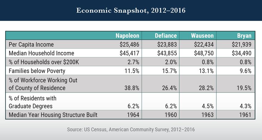
City of Napoleon Master Plan

Public Participation
The City’s Master Plan Update was developed through an
intensive public process that consisted of four primary
elements: project meetings guided by the public works director,
stakeholder interviews, community forums, and a year-long
interactive community survey.

Department / Staff Meetings
Numerous meetings were held at the direction of City staff to
help frame the Plan’s development. Information and action
items generated from these meetings helped to guide the
engagement and data collection process.

Stakeholder Interviews
The Plan was developed under the guidance and advice of
department heads, elected officials, and key planning and
economic development officials. They were active during the
process by informing their peers of the survey and events that
were scheduled for public participation.

Community Survey
A 17-question community-wide survey was deployed during the
planning process. The community surveys were made available
online and in hard-copy beginning June 2018 and remained
open through April 2019. Over 600 residents completed the
surveys. Results from this survey, along with the survey
completed in 2016 by the National Research Center, helped to
frame many of the recommendations framed in this plan.

The following infographics provide a detailed outline of the
results.

                                                                                            Page 5
                    Executive Summary | Plan Participation | Planning Conditions | Planning Area Issues and Recommendations | General Recommendations | Plan Implementation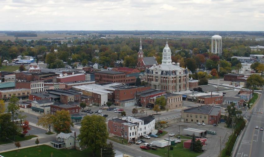
City of Napoleon Master Plan

                                                                        Page 6
Executive Summary | Plan Participation | Planning Conditions | Planning Area Issues and Recommendations | General Recommendations | Plan Implementation
City of Napoleon Master Plan
Community Forum
The community forum held on January 17, 2019 at Oberhaus
Park provided residents and community stakeholders with an
overview of the planning process, a snapshot of the survey
results, and an opportunity to participate in interactive visioning
exercises. The audience received anonymous voting devices and
was asked their preferences on various questions and ideas. This
visioning exercise helped in framing the Plan’s strategies and the
implementation table presented in this Plan. An overview of the
results of the visioning exercise can be found in the following
infographics.

                                                                                             Page 7
                     Executive Summary | Plan Participation | Planning Conditions | Planning Area Issues and Recommendations | General Recommendations | Plan Implementation
City of Napoleon Master Plan
Planning Conditions
It is important that community officials and stakeholders have a
firm understanding of the conditions of the community in which
they live…
Some of the key planning issues that affect Napoleon include:
According to projections prepared by ODSA’s Office of
Research, Henry County is anticipated to decline in
population through 2040, as is most of Northwest Ohio,
however the City’s population is anticipated to remain
stable. Residents from outlying areas in the county shop
and work in Napoleon.
Shifting demographics that include an increase of
residents since 2000 in age cohorts over 45 while losing
residents in cohorts under 45. However, since 2010, the
City is benefiting from an uptick of young families in the
35-44 age cohorts, many of which are former City
residents that chose to return to the City to raise their
children in a safe community with new schools.
Key elements of the community could benefit from The neighborhoods adjacent to the downtown have well-kept historic properties.
improved wayfinding signage, pedestrian connectivity,
bikeways and neighborhood recreational opportunities. Recent infrastructure improvements in the downtown developed in collaboration with the Ohio EPA, and
Assets like Tow Path Trail remain relatively hidden from area and the outdoor refreshment area are helping to enhancing potable water treatment and distribution to
the community. build forward progress. However, impediments like the ensure compliance with applicable rules and regulations.
Almost 40% of Napoleon’s workforce is employed outside building decay and other nuances like the lack of D-5
of Henry County. While it was anticipated that the liquor licenses, traffic, and hodgepodge land uses as well
improvements to US 24 would be beneficial to Napoleon, as poor interconnectedness along the riverfront pose
it is likely that it could be making it easier for residents to concerns to the downtown’s potential vibrancy.
commute somewhere else to work. The survey results Developing innovative funding and timing strategies to
indicated that folks shop primarily outside of the repair the City’s aging infrastructure, complying with the
community, either in Lucas County (Fallen Timbers / Long Term Control Plan and National Pollutant Discharge
Maumee) or Defiance. Elimination System (NPDES) Permit Compliance Schedule
Page 9
Executive Summary | Plan Participation | Planning Conditions | Planning Area Issues and Recommendations | General Recommendations | Plan ImplementationCity of Napoleon Master Plan
Demographic Trends
A portion of this Plan Section is based on a separate
Demographics Benchmarks Report that was prepared as part of
the planning process. Some notable benchmark indicators that
are favorable to Napoleon include:
Napoleon outshines its regional peer communities in
areas of per capita income, households with incomes
over $200K, percentage of residents with graduate
degrees, and age of housing, with fewer families in
poverty.
A general uptick in 35-44 age cohorts returning to the
community to live and raise children, likely due to
affordable housing and good schools.
A higher percentage of Napoleon’s workforce (26.5%)
hold management or professional occupations within
their employment sectors. The same percentage of
workforce is employed in the manufacturing sector.
Low housing vacancy which indicates a general need for
additional residential housing opportunities. Rental
occupied households in Napoleon also have the least
household burden. When compared to its nearby peer
Napoleon has fewer single family residential homes built in nearby communities. This could be detrimental in that
communities, Napoleon also has a lower percentage of
in the community since 2000 compared to Bryan, it may assist in population decline as families leave the
rental occupied households that spend more than 30% of
Defiance and Wauseon. This general lack of liquidity in community to live closer to their employment.
their income on gross rents.
the market could be aiding is the City’s stagnant growth A decline in young family households headed by
Some demographic areas of concern include: pattern. individuals in the 25-49 age cohorts.
Stable but stagnant population trends. Recent estimates Napoleon’s population is aging: In 2000, median age of
prepared by the American Community Survey (ACS) data residents was 36.2 years of age. In 2017, mean age was
point to the City’s population increasing 1.9% but other estimated at 40.8, a 12.7% increase.
sources from the US Census show a population decline. Population is more mobile than in peer communities, as
This Plan was drafted using demographic estimates so it 38% of Napoleon’s workforce works outside of Henry
is important that City officials update sections of this Plan County, compared to 28%, collectively, of the workforce
in light of the 2020 Census results.
Page 10
Executive Summary | Plan Participation | Planning Conditions | Planning Area Issues and Recommendations | General Recommendations | Plan ImplementationCity of Napoleon Master Plan
Age Characteristics and Median Age
Since 2000, the City has witnessed an increase of residents in the
age cohorts over 45 while losing residents in cohorts under 45.
However, since 2010, the City is benefiting from an uptick of
young families in the 35-44 age cohorts, many of which are
former City residents and chose to return to the City to raise
their children.
In 2017, the median age of City residents was estimated at 40.8 Household Income
years old, which is 5.5 years higher than state and US averages. Median income is an important statistic as income may
Since 2000, median age has increased 13%. determine what goods and services a household can and cannot
afford to purchase.
Employment
Napoleon is home to a strong base of residents employed in According to the Census estimates, Napoleon’s median
manufacturing and transportation / warehousing positions, as household income in 2017 was $45,417, generally higher than
over 36% of City residents are employed in these industries. nearby communities of Defiance and Bryan, but lower than
Approximately 18.5% are employed in healthcare and social Wauseon. Napoleon’s median household income lags behind
assistance fields, with 7.5% employed in retail sector fields. the State of Ohio ($50,674) by $5,257.
Within these sectors, roughly 8% hold management positions.
Page 11
Executive Summary | Plan Participation | Planning Conditions | Planning Area Issues and Recommendations | General Recommendations | Plan ImplementationCity of Napoleon Master Plan
household income towards their gross rents. This could be due
to a multitude of conditions including: higher median incomes,
lack of newer rental units that can demand higher rents, or for
other reasons. Nevertheless, housing and rental costs in
Napoleon are more affordable than nationally.
Housing Costs as a Percent of Household Income, 2016*
60% 51.5%
48.2% 47.3%
50% 43.9%
38.1%
40% 31.5% 30.6%
30% 22.4% 21.7% 19.7% 20.7%
17.4%
20%
10%
0%
Napoleon Defiance Wauseon Bryan City Region U.S.
Monthly cost >30% of household income
Gross rent >30% of household income
Population / Population Projections
According to the 2010 Census, Napoleon’s population was
8,749, a decrease of 6% since the previous decennial census.
Recent estimates prepared by the ACS data have the City’s
population at 8,646. However, City officials believe this number
does not reflect current conditions due to low residential
Housing Conditions and Trends vacancies and demand for housing.
Residential growth has been stagnant in the City since 2000, and
According to projections prepared by the ODSA’s Office of
most especially since 2010. The lack of liquidity for single family
Research, Henry County is anticipated to decline in population
homes and apartments, and property maintenance issues in
through 2040, as is most of Northwest Ohio. Other counties
certain neighborhoods has created interesting dynamics. While
located in the northwest Ohio footprint are also estimated to
owners of occupied housing in Napoleon generally pay more of
witness a decline in population. Wood County’s population is
their income towards mortgage costs (22.4%) than their nearby
expected to remain the most stable due to an inflow of residents
peers, burdens for renters are generally less. Approximately
from Henry and Lucas Counties.
31.5% of rental households in Napoleon pay more than 30% of
Page 12
Executive Summary | Plan Participation | Planning Conditions | Planning Area Issues and Recommendations | General Recommendations | Plan ImplementationCity of Napoleon Master Plan
Environmental Considerations
Floodplains are areas adjacent to bodies of water, which over
time, diverse weather conditions, and increased development
are prone to flooding. The two floodplain classifications as
defined by the Federal Emergency Management Agency (FEMA)
are the 100-year and 500-year flood hazard areas (FHA), and
both areas are present in Napoleon.
Several areas within the 100-year flood zone have experienced
flood events of differing intensities over the past few decades.
These areas are either adjacent to the Maumee River or the
three primary creeks that traverse the City: Garrett, VanHyning
or Oberhaus Creeks. Garrett Creek, adjacent to the City’s
municipal golf course, frequently overflows onto adjacent lands.
There are a variety of areas in and around Napoleon that are
wetlands or a variant thereof, and may pose a variety of
development-related constraints. (see Map: Environmental
Conditions).
Most of Napoleon’s environmental hazards are flood-related due to the Maumee River levels rising during peak
times. Garret Creek, adjacent to the municipal golf course, is adversely affected during these rain events.
Page 13
Executive Summary | Plan Participation | Planning Conditions | Planning Area Issues and Recommendations | General Recommendations | Plan ImplementationCity of Napoleon
ST R
T 10
8
Master Plan
13 A
D
CO RD 12
CO R
TWP RD 11
TW P RD 14 B
Environmental
ST RT 108
Conditions
E
AMERICAN
US 24
US 2
4
E
TWP RD R TAT
ENTERPRIS E
CO RD R ERS
FREEDOM IN T
US 6
INDUSTRIA L
S E
KEN JAM
BEC K US 6
L EE
EE
KL
BONAPARTE
C
BE
CO RD 14 B
INDEPENDENCE
D 424
INDEPENDENCE CO R
TWP RD 15 A
INTERCHANGE LAMAR
OO D
CO RD 15
OAK W
COMMERCE
Legend
WOOD
IA
ER
SCOTT
CEDARBROOK
ST
LAKEVIEW
WI
HOLLY BAUMAN
MICHAEL WISTERIA
SUTHERLAND
HI LL
DEVONSHIRE
K
ROO
BRADFORD
ST RT 110
LE Y B
PATRICIA
THOMAS
VA L A LE
GLENWOOD
CEDARBROOK
NY D
SU N LARK FAIR
Napoleon Corp Boundary
DO W NORTHCREST C
ME A OLD R EEK
COURTLAND HUDSON
NO RTHC REST
GRENWICH
TRAIL
DE RO ME DEROME
Streets
PR80132
HARMONY
Parcels
WESTWOOD MELODY
HARMONY
RYE
DETROIT
RICHMAR
GLENBROOK
CO
INDIANA
RD TAYLOR YEAGER UNI O
50 LAGRANGE N
Railroads
0
RE
DODD
OAKDALE
MO
MICHIGAN
FI L
SHEFFIELD
24
HIGHLAND
ST
T
OHIO RTH PO
WILLARD
VOCKE
E
US NO DE
VE
MA
NS
ON
REYNOLDS
P LE
PE AD
KNA ILRO
STO
Maumee River / Ponds / Hydrography
RA WASHINGTON
UT
WO O
D LAW EY
N R
CA L BY
WESTMORELAND
WA
24
STO
SHE N
NTO
SC
YN
US
LYNNE CLI
LB E
U
OT
E
HOBSON
T
LYNNE KO
T
GLENWOOD
MO
JEF
Floodplains
TWP RD P 3
NR
D
CLAIRMONT
F
LU MBAR
OE
ERS
HIGH MAIN
ON
WESTMONT RIESER
LEONARD
PER
WE
EW
R
TYL
Y
WESTCHESTER
BS
VI
Surface Water / Wetland Type
RO
ER
ER
BRIARHEATH
TER
CLINTON
M
RIV
r
NT
A IN
HALEY
KENILWORTH
FRO
e
ERIE
v
IN
TWP RD 12
i
NORTON
ARDEN MA
R
CHELSEA WASHINGTON M
AVO N
AU
e
BROADMOOR M
e
EE
ORWIG
MAIN CLIFF
m
Emergent Wetland
VINE
T
u
ED
LST OR
LE S
a
BA
ROBINWOOD WE SH
WELSTED
M
SHEFFIELD EUCLID
SPRUCE
E E
STRONG UM
LAST
P2
CO R
D MA
Forested/Shrub Wetland
CO RD P BECKHAM
MEEKISON
PARK
CO RD P
GARDEN
2ND
CO BARNES
PARK
PARK
R
RK
OXFORD
DO
1ST
AP
PA
1 4TH
PI
CAMBRIDGE
AN
OAK BROWNELL
Pond
1ST
PONTIOUS
3RD
ES
5TH
NN
CE WALN UT
VIN SN
E
MARTHA ROHRS
UE HU
CRIPPLE CREEK
Q
DU RS
MO CO RD 802
JA T
PERRY
DAGGETT
HN ORI
S NGS CO RD 805 RAYMOND RAYMOND
LEMANS
LAFAYETTE
Creek / Hydrography
GRAC EWAY
BORDEAUX
FAIRVIEW
CO RD 803
JOLIETTE
E
OR
CO RD 803
GRAC EWAY
M
CO RD 801
CA
CAPRI
CO R D 810
SY
MOSER
Woodlands
SED
WA
R D
WILLIAM SBURG HUDDLE CO RD 810 A
LD
F IE
ER
ST
CA
THERSHAN
E
C
CH
BE
NEWARD
Note: Map for illustrative purposes only, and should
BUCKEYE TWP RD O 3
ROHM
not be used for design and construction purposes.
BR
ORCHARD
ARI
C LI F
CO
F
OAK
RD
11
HILLTOP
C
CO
RD 1
1 B CO RD
ST RT 108
O
TWP RD 11
CO RD 14
DZ
CO R
CO
R D
M1
R K
PA
NE
AY
CO RD 12
W
TWP RD N 4
CO RD 424 TWP RD N 2
Miles Source: Henry County Auditor, Engineer, Napoleon, US FWS
0 0.25 0.5 1 1.5 2City of Napoleon Master Plan
Economic Development
City officials use a variety of financial and tax incentives to
encourage and stimulate new business investments, with the
promotion of these incentives being handled primarily by the
Henry County Community Improvement Corporation or
Napoleon-Henry County Chamber of Commerce.
The City has two main business park areas, Commerce Park
(south of US 24/6) and the “Northpointe” Business Park (north
of US 24/6).
Commerce Park is located on the east side of Napoleon north of
the Maumee River but south of US 24 and has over 260 acres of
site ready land. The Park is fully supplied with all utilities and
zoned properly. The park also has many parcels served by the
Napoleon, Defiance and Western Railroad.
Northpoint Business Park, located north of US 24, is the largest
industrial park in Henry County with over 350 acres of
commercial and industrial-zoned site ready property. This park
is fully supplied with all utilities and has approximately 300 acres
of undeveloped land. Future road upgrades and extensions are In 2018, City officials kicked off a three-year improvement program of the downtown including the development of an
currently being planned, and the 2nd river bridge tentatively outdoor refreshment area and wider sidewalks that provide for outdoor dining areas.
planned for 2022 will help to link this business park to southerly
At the present time, there are four CRAs in the City limits (CRA The City of Napoleon, through the assistance of the Henry
destinations in the community.
Zones #2, #6, #7, and #8) where property tax incentives can be County Improvement Corporation, also utilizes the EZ #123
authorized by City council to encourage new construction or the program that provides qualifying companies property tax
The primary incentives that the City utilizes for economic
revitalization of residential, commercial and industrial abatement on real property investments. There is currently one
development include property tax incentive programs (CRA and
properties (see Map: Economic Incentive Areas). active EZ abatement in the City.
Enterprise Zone [EZ]), revolving loan and micro loan funds, and
jobs grant (income tax refund) programs. The City, as of 2018,
In 2018, the City updated their incentive areas by expanding
also benefits from having a good portion of its area included as
CRA #6 for a housing project at the former West Elementary
an Opportunity Zone, which provides investors with a variety of
School. These areas can be modified and amended over time.
tax deferment and other advantages.
There are currently nine active post-1994 CRA abatements.
Page 15
Executive Summary | Plan Participation | Planning Conditions | Planning Area Issues and Recommendations | General Recommendations | Plan ImplementationCity of Napoleon
ST R
T
10 8
Master Plan
A
D 13
CO R
CO RD 12
TWP RD 11
TWP RD 14 B
Economic Incentive
ST RT 108
E
AMERICAN
Areas
US RT 6 US RT 24
US RT 6
U S RT
24
E
TWP RD R TAT
ERS
ENTERPRISE
CO RD R US 6 6
FREEDOM US INT
INDUSTRIAL
S
GLEN ARB OR
ESM
KENJA
BEC K
L EE
E
KL E
BONAPA RTE
BEC
CO RD 14 B
INDEPENDENCE
6
RT
U S RT 6 D 424
U S INDEPENDENCE CO R
TWP RD 15 A
6
US S 6
LAM AR
U INTERCHANGE
OO D
US RT 6
CO RD 15
OAKW
6
RT
COMMERCE
US
WOOD
CEDARBROOK
WISTERIA
SCOTT
LAKEVIEW
WISTERIA
HOLLY BAUMAN
MICHAEL HILL
SUTH ERLAN D
6
US S 6 O OK
YB R ST RT 110
BRADFORD
U E
THOMAS
PATRICIA
VALL
CO
ALE
GLENWOOD
N YD
CEDARBROOK
M
SUN
M
L AR K FAIR
ER
D OW
CE
MEA NORTHCREST C
OL D REEK
COURTLAND
HUDSON
Legend
NORTHCR EST
GRENWICH
TRAIL
DER OM E DEROME
OD
NORWO
PR80132
24
US
US HARMONY
Napoleon Corp Boundary
RT US RT 6
6
WESTWOOD MELODY
HARMONY
RYE
RICHMAR
DETROIT
GLENBROOK
CO
INDIANA
R YEAGER UNIO
D5 TAYLOR LAGRANGE N
Streets
00
FILMORE
OAKDALE
MICHIGAN
24
SHEFFIELD
VO
OT
ST
HIGHLAND
RT OHIO P
CK E
E
DE
WILLARD
US
VE
DODD
H
RT
NS
NO
MA
ON
P
REYN OLDS
PE AD
LE
A
Parcels
STO
KN O
ILR WASHINGTON
RA
UT
WO O
D LAW Y
N RE
CA
LB Y
WESTMOR ELAND
WA
SH E
STO
N
NTO
YN
SC
LYNNE CLI
U
LB E
O
E
T
TT
LYNNE KO HOBSON
GLENWOOD
MO
Railroads
AR D
TWP RD P 3
N
JE F
CLAIRMON T
RO
F
B
ER S
E
LUM
HIG H MAIN
ON
WESTMONT
24 LEONARD
PER
IE ER
RT
RV IES
RY
WE
US
W
TYL
R
WESTCHESTER
BS T
N
NTO
Maumee River / Ponds / Hydrography
RO
ER
CLI
E
E
BRIARHEATH
RIV
M
R
r
AIN
NT
HALEY
KENILWORTH
FR O
e
ERIE
v
AR
IN
i
MA
TWP RD 12
NORTON
DEN
R
CHELSEA WASHINGTON M
AVON
AU
e
BROADMOOR M
e
EE
ORW IG
CRA 2 (Pre-94)
CL
MAIN I FF
m
VIN
u
TED RT
E
ELS O
a
L ES ROBINWOOD W SH
BA WELSTED
M
SHEFFIELD EUCLID
SPRUCE
STRONG E E
UM
LAST
P2
MA
CRA 6
D
CO R
CO RD P BECKHAM
MEEKISON
PARK
CO RD P
GARDEN
2ND
BARNES
CO
RD
PARK
PARK
O
K
OXFORD
1
R
PA
1ST
AP
PI
4TH
CAMB RIDGE
AN
OAK BROWNELL
CRA 7
1ST
S PONTIOUS
3RD
5TH
N NE
CE WALNUT
VIN E ROHRS
SN
Q UE HU MARTHA
DU RS
T
JA MO CO RD 802
EK
PERRY
H
DAGGETT
NS O RI N
PL E C R E
G CO RD 805 RAYMOND RAYMOND
CRA 8
LAFAYETTE
S
LEMANS
GRACEWAY
BORDEAUX
CO RD 803
FAIRVIEW
JOLIETTE
E
CO RD 806
OR
CR IP
CO RD 803
GRACEWAY
M
CO RD 808
CO RD 801
CA
CAPRI
SY
0
CO RD 81
SED
MOSER
WA
RD
WILLIAMSBURG HUDDLE CO RD 810 A
LD
FIE
ER
ST
CA
THER S H
E
Note: All areas in the city are part of
CH
NE
C
AN
BE
WA
R D
Enterprise Zone #123 that provides
3
R DO
BUCKEYE TW P
for commercial and industrial property
ROHM
D
AR
CH
improvements contigent upon approval
OR
BR
OA
IA
K
CLR
IF
CO
F
OAK
RD
by the Henry County Commissioners.
11
HILLTOP
C
CO
R D 11
B CO RD O
TWP RD 11
CO RD 14
DZ
R
CO
CO
RD
M1
K
AR
EP
N
AY
ST RT 108
CO RD 12
W
TWP RD N 4
WAY N
E
PA
RK
CO RD 424 TWP RD N 2
Miles Source: Henry County Auditor, Engineer, Napoleon, Reveille
0 0.25 0.5 1 1.5 2City of Napoleon Master Plan
Existing Land Use and Zoning
Land Use Conditions
The existing land use in the City includes a mix of residential
(primarily single-family), commercial, industrial, public/
institutional and agricultural/vacant land (see Map: Existing
Land Use).
The most prevalent land use is residential (33% of total land
uses). The residential development includes a mix of older
residential areas adjacent to the downtown area, established
residential areas near Glenwood Avenue and on the south side
of the river, with newer suburban-like residential areas near
West Riverview Avenue. Smaller residential areas are located
near Oakwood Avenue and East Riverview Avenue away from
the downtown area. Several small apartment complexes, multi-
family developments, individual multi-family buildings, and
mobile home parks are located in the City. Most of the new Smaller commercial nodes are located along East Riverview US 24 and the Maumee River, centered on the Industrial Drive
single-family residential development is occurring in the Avenue, East Maumee Avenue, South Perry Street on the south interchange and Enterprise Avenue. This area is easily accessible
subdivisions abutting West Riverview Avenue near the river, and side of the river, and at the intersection of Woodlawn Avenue by highway and rail and includes several large factory complexes
west of Glenwood Avenue near the school complex. A small and Glenwood Avenue. Henry County Hospital, the largest as well as industrial parks with a number of smaller
newer subdivision is also located on the south side near Appian office/professional service use in the City, is located in the far- industrial/warehousing operations and “shovel-ready” lots
Avenue. A new villa style residential development is currently east side of the City on East Riverview Avenue. available for development. A small industrial area is located on
being constructed for the former West School site. the south side of the Maumee River, adjacent to the large
There are a few office uses (primarily government-related) in Campbell Soup complex located outside the City.
In terms of commercial land uses (17% of total land usage), the the area near Oakwood Avenue and Independence Drive, and
City’s primary commercial corridor is located along Scott Street some professional services/office uses in the area along The City of Napoleon includes a fair amount of public and
from the US 24 interchange to Lagrange Street. National and Westmoreland Drive near the Woodlawn Avenue interchange institutional land uses (23% of total land uses) that includes city
local retailers and restaurants are located in this corridor, with US 24. There are several undeveloped parcels zoned for and county owned lands, municipal parks (Glenwood, Oakwood,
drawing from City residents as well as from travelers and future commercial development adjacent to the US 24/ Ritter, and Oberhaus) and small parks offering ball fields, play
residents from nearby communities. Industrial Drive interchange (roughly 20% of land uses are areas, recreational trails, a fishing lake, boat launches, and
vacant or utilized for agriculture). scenic views of the Maumee River. The City’s park system also
The downtown area remains a hub of commercial activity as includes an outdoor swimming pool and golf course.
well, with more local and specialized shops and restaurants as Industrial uses (8% of total land uses) in Napoleon are
well as professional services, offices, and government functions. concentrated in the area east of Oakwood Avenue, between
Page 17
Executive Summary | Plan Participation | Planning Conditions | Planning Area Issues and Recommendations | General Recommendations | Plan ImplementationCity of Napoleon Master Plan
The City’s green space includes several cemeteries, the county
fairgrounds, and some woodlands. Public and institutional land
uses include the county courthouse, the school complex, the
library, the water treatment plant (WTP) and wastewater
treatment plant (WWTP), and other public utilities.
Land Use Valuations
Residential land uses occupy 1,118 acres and comprise 33% of
the City’s total land use. However, its taxable assessed value
comprises almost 74% of its total valuation. Residential land
uses yield the most property valuation at $98,856 per acre.
Commercial land uses occupy 573 acres, or 17% of assessed land
usage. Its taxable assessed value comprises 19% of the City’s
total valuation. In 2018, commercial land uses generated
$49,101 per acre.
In 2018, land utilized for industrial purposes consumed 8% of the
City’s acreage or approximately 273 acres. Its taxable assessed
value comprised only 7% of the City’s total valuation. Industrial
land uses yield $36,443 per acre.
Approximately 682 acres or 20% of the City is occupied by
agricultural land uses, most of which are enrolled in the Current
Agricultural Use Value (CAUV) program. Its taxable assessed
value comprises less than one half of one percent of the City’s
total valuation. Agricultural land uses generated $993 per acre
in property valuation in 2018.
Napoleon has a notable footprint of land utilized for public and
institutional uses. Land dedicated to these uses amounts to
roughly 23% of the City’s total land usage. These land uses,
although taxable value is recorded, do not pay property taxes,
but do pay special assessments in certain situations.
Page 18
Executive Summary | Plan Participation | Planning Conditions | Planning Area Issues and Recommendations | General Recommendations | Plan ImplementationCity of Napoleon
ST
RT 1 08
Master Plan
13 A
D
CO RD 12
CO R
TW P RD 14 B
Existing Land Use
ST RT 108
E
TWP RD 11
AMERICAN
US 24
E
TAT
ENTERPRIS E
TWP RD R
CO RD R ERS
FREEDOM IN T
INDUSTRIA L
S E
KEN JAM
BEC K US 6
L EE
EE
KL
BONAPARTE
C
BE
CO RD 14 B
INDEPENDENCE
6 INDEPENDENCE
US
TWP RD 15 A
INTERCHANGE LAMAR CO RD 424
OO D
CO RD 15
OAK W
TWP RD Q 1
COMMERCE
WOOD
IA
ER
SCOTT
CEDARBROOK
ST
LAKEVIEW
WI
HOLLY BAUMAN
MICHAEL WISTERIA
SUTHERLAND
HI LL
DEVONSHIRE
Legend
K
ROO
BRADFORD
LE Y B ST RT 110
PATRICIA
THOMAS
VA L E
DA L
GLENWOOD
CEDARBROOK
NY
SU N L ARK FAIR
DO W C
ME A NORTHCREST OLD REEK
COURTLAND HUDSON
NO RTHC REST
GRENWICH
TRAIL
DE RO ME DEROME
Napoleon Corp Boundary
TWP RD 16
PR80132
HARMONY
Parcels
WESTWOOD MELODY
HARMONY
RYE
DETROIT
RICHMAR
GLENBROOK
CO
INDIANA
RD TAYLOR YEAGER UNI O
LAGRANGE N
Streets
50
0
RE
DODD
OAKDALE
MO
MICHIGAN
FI L
SHEFFIELD
24
HIGHLAND
ST
H T
OHIO RT PO VOCKE
WILLARD
E
US NO DE
VE
MA
NS
ON
REYNOLDS
P LE
PE AD
Railroads
KNA ILRO
STO
RA WASHINGTON
UT
WO O
D LAW Y
N RE
CA L BY
WESTMORELAND
WA
STO
SHE N
NTO
SC
YN
LYNNE CLI
LB E
U
OT
TWP RD P 1
E
HOBSON
T
LYNNE KO
T
GLENWOOD
Maumee River / Ponds / Hydrography
MO
JEF
TWP RD P 3
NR
D
CLAIRMONT
F
LU MBAR
OE
ERS
HIGH MAIN
ON
WESTMONT LEONARD WASHINGTON
EW R
VI S E
WE
ER RIE
TYL
Parks
WESTCHESTER
BS
RO
ER
BRIARHEATH
TER
CLINTON
M
RIV r
NT
A IN
HALEY
KENILWORTH
FRO
e
ERIE
IN
v
TWP RD 12
i
NORTON
ARDEN MA
R
CHELSEA M
AVO N
AU
e
BROADMOOR M
me Agricultural / Vacant
24 EE
ORWIG
CLIFF
US MAIN VINE
ED T
u
ES LST OR
a
BA
L ROBINWOOD WE SH
WELSTED
M
SHEFFIELD EUCLID
SPRUCE
EE
Industrial
STRONG UM
LAST
P2
CO R
D MA
CO RD P BECKHAM
MEEKISON
PARK CO RD P
GARDEN
2ND
CO BARNES
PARK
PARK
R
RK
OXFORD
DO
1ST
AP
PA
1
PI
Commercial
CAMBRIDGE
4TH
AN
OAK BROWNELL
1ST
PONTIOUS
3RD
S
C EN
NE
WALN UT 5TH
VIN ES N
E
MARTHA ROHRS
U HU
CRIPPLE CREEK
Q
DU RS
Multi-Family Residential
JA T MO CO RD 802
PERRY
DAGGETT
HN ORI
S NGS CO RD 805 RAYMOND RAYMOND
LEMANS
LAFAYETTE
GRAC EWAY
BORDEAUX
FAIRVIEW
CO RD 803
JOLIETTE
E
OR
CO RD 803
GRAC EWAY
M
CO RD 801
CA
CAPRI
CO R D 810
SY
Residential
MOSER
SED
WA
R D
WILLIAM SBURG HUDDLE CO RD 810 A
LD
F IE
ER
Public / Institutional
ST
CA
THERSHAN
E
C
CH
BE
NEWARD
BUCKEYE TWP RD O 3
ROHM
BR
ORCHARD
ARI
C LI F
CO
Note: Land Uses as determined by the
F
OAK
RD
HILLTOP 11
C
landowner and County Auditor for tax purposes.
CO RD 11 B
CO RD O
TWP RD 11
CO RD 14
As Of January 2019.
Z
CO
D
R
CO R
DM
1
R K
PA
NE
AY
ST RT 108
W
CO RD 12
TWP RD N 4
TWP RD N 2
CO RD 424
Miles Source: Henry County Auditor, Engineer, Napoleon, Reveille
0 0.25 0.5 1 1.5 2City of Napoleon Master Plan
Zoning Conditions Woodlawn Avenue east of US 24, and on scattered sites on the these uses are located in a number of different zoning districts.
The Napoleon Zoning Ordinances includes four residential south side of the City. Most of the undeveloped area within City limits is located near
zoning districts ranging from “R-1” (suburban residential) to “R- US 24 and is zoned for commercial or industrial development,
4” (high-density residential) with varying minimum lot sizes. One The largest concentrations of commercial zoning are located although there are undeveloped areas zoned for residential
and two family dwellings are permitted in all residential zoning along the City’s primary commercial corridor on Scott Street, development on the west and south sides of the City.
districts, although the R-1 and R-2 zoning districts are intended extending from US 24 to Lagrange Street, and in the downtown
primarily for single family residences, while multiple family area (including both sides of the river). There are also areas of All of the City’s public and institutional land uses are currently
dwellings are permitted only in the R-4 zoning district. commercial zoning along East Riverview Avenue, on Oakwood allowable in each of the City’s zoning districts. It is
Avenue near US 24, and in several small commercial nodes such recommended that the zoning code be updated to create a
The Zoning Ordinances include five commercial zoning districts as along South Perry Street south of Barnes Avenue and at the special or institutional zoning classification to minimize
(general, community, local, planned, and highway). intersection of Woodlawn Avenue and Glenwood Avenue. The incompatibility conflicts. At the present time, Oakwood Plaza is
golf course, school complex, and a large mobile home park are predominately utilized for public and institutional uses but
The C-1 general commercial district serves as the downtown also zoned commercial. located in a C-5 zoning district.
commercial zoning district, the C-2 community commercial and
C-3 local commercial districts are intended for less intense Most of the industrial zoning is located between Oakwood
commercial uses, and the C-4 (planned) and C-5 (highway) are Avenue and the Maumee
intended for more intense and/or large scale commercial uses. River, centered on the US 24
The Zoning Ordinances also include two industrial zoning interchange at Industrial
districts (enclosed industrial and open industrial) and two Drive. There are smaller
overlay districts (floodplain and floodway district and industrially zoned areas
preservation district). Historic design review and preservation located around the City’s
guidelines are applicable to non-residential structures in the water treatment plant at
preservation district. Haley Avenue and West
Riverview Avenue as well as
The Napoleon Zoning Map (see Map: Zoning) shows the zoning on East Maumee Avenue
classification for every parcel in the City, with about half of the adjacent to the Campbell
City zoned residential and the other half zoned commercial or Soup complex.
industrial. The residential zoning is concentrated on the west
and south sides of town, near scenic portions of the riverfront The Napoleon Zoning Code
and the school complex, while the commercial and industrial does not currently have a
zoning is concentrated on the east and north sides of town, near zoning district classification
US 24 and the rail line. Areas with high density (multiple family) for public and semi-public
zoning are located in the perimeter of the downtown area, near uses (schools, parks,
Oakwood Avenue, near Scott Street north of US 24, near cemeteries, public utilities, Oakwood Plaza is predominately utilized for public and institutional uses but located in a C-5 zoning district.
municipal facilities, etc.), so
Page 20
Executive Summary | Plan Participation | Planning Conditions | Planning Area Issues and Recommendations | General Recommendations | Plan ImplementationCity of Napoleon
ST R
T
10 8
Master Plan
A
D 13
CO R
CO RD 12
TWP RD 11
TWP RD 14 B
Zoning
ST RT 108
E
AMERICAN
US RT 6 US RT 24
US RT 6
U S RT
24
E
TWP RD R TAT
ERS
ENTERPRISE
CO RD R US 6 6
FREEDOM US INT
Legend
INDUSTRIAL
S
GLEN ARB OR
ESM
KENJA
BEC K
L EE
E
KL E
BONAPA RTE
BEC
CO RD 14 B
INDEPENDENCE
6
RT
U S RT 6 D 424
CO R
Napoleon Corp Boundary
U S INDEPENDENCE
TWP RD 15 A
6
US S 6
LAM AR
U INTERCHANGE
OO D
US RT 6
CO RD 15
OAKW
Streets
6
RT
COMMERCE
US
WOOD
CEDARBROOK
WISTERIA
SCOTT
LAKEVIEW
WISTERIA
HOLLY BAUMAN
Parcels
MICHAEL HILL
SUTH ERLAN D
6
US S 6 O OK
YB R ST RT 110
BRADFORD
U E
THOMAS
PATRICIA
VALL
CO
ALE
GLENWOOD
N YD
CEDARBROOK
M
SUN
M
L AR K FAIR
ER
D OW
CE
MEA NORTHCREST C
OL D REEK
Railroads
COURTLAND
HUDSON
NORTHCR EST
GRENWICH
TRAIL
DER OM E DEROME
OD
NORWO
Maumee River / Ponds / Hydrography
PR80132
24
US
US HARMONY
RT US RT 6
6
WESTWOOD MELODY
R1 - Suburban Residential District
HARMONY
RYE
RICHMAR
DETROIT
GLENBROOK
CO
INDIANA
R YEAGER UNIO
D5 TAYLOR LAGRANGE N
00
FILMORE
OAKDALE
R2 - Low Density Residential District
MICHIGAN
24
SHEFFIELD
VO
OT
ST
HIGHLAND
RT OHIO P
CK E
E
DE
WILLARD
US
VE
DODD
H
RT
NS
NO
MA
ON
P
REYN OLDS
P E OAD
LE
A
STO
KN ILR WASHINGTON
RA
UT
WO O
D LAW
R3 - Moderate Density Residential District
N R EY
CA
LB Y
WESTMOR ELAND
WA
SH E
STO
N
NTO
YN
SC
LYNNE CLI
U
LB E
O
E
T
TT
LYNNE KO HOBSON
GLENWOOD
MO
AR D
TWP RD P 3
N
JE F
CLAIRMON T
RO
F
B
ER S R4 - High Density Residential District
E
LUM
HIG H MAIN
ON
WESTMONT
24 LEONARD
PER
IE ER
RT
RV IES
RY
WE
US
W
TYL
R
WESTCHESTER
BS T
N
NTO
RO
ER
CLI
E
E
BRIARHEATH
RIV
M
R
r
AIN
T
HALEY
KENILWORTH ON
e C1 - General Commercial District
FR
ERIE
v
AR
IN
i
MA
TWP RD 12
NORTON
DEN
R
CHELSEA WASHINGTON M
AVON
AU
e
BROADMOOR M
e
EE
ORW IG
CL
MAIN I FF
m
VIN
u
TED RT
E
C2 - Community Commercial District
ELS O
a
L ES ROBINWOOD W SH
BA WELSTED
M
SHEFFIELD EUCLID
SPRUCE
STRONG E E
UM
LAST
P2
CO R
D MA
CO RD P BECKHAM
MEEKISON
PARK
C3 - Local Commercial District
CO RD P
GARDEN
2ND
BARNES
CO
RD
PARK
PARK
O
K
OXFORD
1
R
PA
1ST
AP
PI
4TH
CAMB RIDGE
AN
OAK BROWNELL
1ST
S PONTIOUS
3RD
5TH
E
NN
C4 - Planned Commercial District
CE WALNUT
VIN E ROHRS
SN
Q UE HU MARTHA
DU RS
T
JA MO CO RD 802
EK
PERRY
H
DAGGETT
NS O RI N
PL E C R E
G CO RD 805 RAYMOND RAYMOND
LAFAYETTE
S
LEMANS
GRACEWAY
BORDEAUX
CO RD 803
FAIRVIEW
JOLIETTE
E
C5 - Highway Commercial District
CO RD 806
OR
CR IP
CO RD 803
GRACEWAY
M
CO RD 808
CO RD 801
CA
CAPRI
SY
0
CO RD 81
SED
MOSER
WA
I1 - Enclosed Industrial District
RD
WILLIAMSBURG HUDDLE CO RD 810 A
LD
FIE
ER
ST
CA
THER S H
E
CH
NE
C
AN
BE
WA
R D
I2 - Open Industrial District
O3
RD
BUCKEYE TW P
ROHM
FP - Floodplain District
D
AR
CH
OR
BR
OA
IA
K
CLR
IF
CO
F
OAK
RD
11
HILLTOP
POD - Preservation Overlay District
C
CO
R D 11
B CO RD O
TWP RD 11
CO RD 14
DZ
R
CO
CO
RD
M1
K
AR
EP
N
AY
ST RT 108
CO RD 12
W
TWP RD N 4
WAY N
E
PA
RK
CO RD 424 TWP RD N 2
Miles Source: Henry County Auditor, Engineer, Napoleon, Reveille
0 0.25 0.5 1 1.5 2City of Napoleon Master Plan
Parks and Recreation approved by the voters. An estimated 3.5 million dollar facility
is planned for construction beginning in 2020 with completion
With a current staff of six full-time and 30 part-time employees,
scheduled for 2021.
Napoleon’s Parks and Recreation Department (Parks
Department) oversees numerous seasonal and non-seasonal
recreational programs and maintains ten parks, two cemeteries,
and a community pool and golf course. Total department budget
in 2018 was $1,050,000, with $93,000 allocated for yearly
capital improvements. The Parks Department operates on a
0.2% income tax, generated by a permanent levy passed in 1985
and renewed by voters every half-decade since then. In 2017,
the levy generated $615,000 and accounts for 66% of the
department’s budget.
The Parks Department currently collaborates with groups such
as the Napoleon Diamond Boosters, the Soccer Club, Lady Cat
Softball club, the Buckeye Trail and others to help provide
recreational opportunities in the community. Service
organizations including the United Way, the Rotary and Lions
Clubs. The Henry-Wood Sportsman Alliance also partner with
the Parks Department.
Additional guidance is provided to the Parks Department by the
mayor-appointed Parks and Recreation Board. The duty of this
board is to review park policies and fees. These
recommendations are passed to City Council where final
decisions are made.
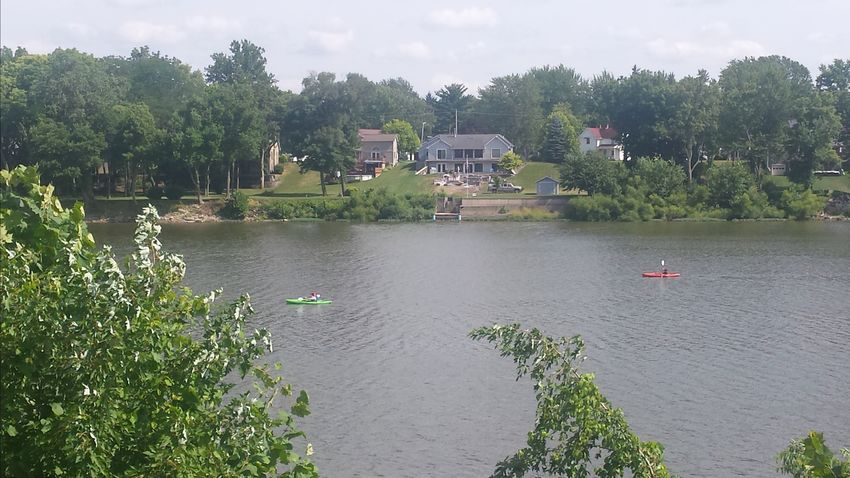
Top: The Parks Department has a visible presence on the Maumee
River with water markers along the river in selected locations
One of the more immediate needs of the community is the informing boaters of their specific location.
replacement of the City’s aging swimming pool. An initiative to
build a new aquatic facility was spearheaded by a newly formed Over the past several years, City residents have expressed an interest
pool commission. This commission worked with City staff to for additional river-related and riverfront activities and the private
sector has helped to accommodate this desire.
develop preliminary plans for a new swimming pool facility and
attached golf course clubhouse. To fund the project, a property
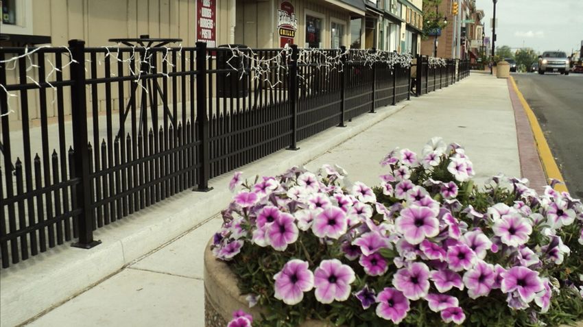
Right: Restaurant goers can utilize the docks at Azul Tequila along
tax bond issue was placed on the May 2019 ballot and was East Riverview Avenue.
Page 22
Executive Summary | Plan Participation | Planning Conditions | Planning Area Issues and Recommendations | General Recommendations | Plan ImplementationYou can also read