Brazil: Integrated assessment and planning in the context of the sustainable Amazon Plan: With focus on the BR-163 Highway area of influence and ...
←
→
Page content transcription
If your browser does not render page correctly, please read the page content below
Brazil: Integrated assessment and
planning in the context of the
sustainable Amazon Plan:

With focus on the BR-163 Highway area of
influence and the soybean sector


Preface

Soybean crop expansion in the Amazônia is a matter of contention in this millennium due to environmental
sensitivity and international visibility of the region. The soybean has become the main Brazilian export
commodity, with the central-western region the greatest producer in the country, which are mainly cerrado
(savannah) areas. This central-western region accounts for around 26.8 per cent of all cultivated areas in
Brazil. The State of Mato Grosso, part of the Legal Amazônia, contributes 14.0 per cent of all cropped areas
and 24.4 per cent of all soybean cultivation areas in Brazil.

Technological breakthroughs and the availability of flat and cheap land provided enormous competitive
advantage to Brazil in the international market, in spite of the high transportation costs. Transportation costs
are the major problem that drives soybean cultivation to the Amazonian forest region, not the territorial
aspect of soybean cultivation. We do recognize the strategic role of the agribusiness for the future of this
country and the legitimate interest of the soybean sector in the pavement of the BR-163 Highway to reach the
port of Santarém-PA, enabling the sector to benefit from a multi-modal road-fluvial transport system. This
will reduce transportation costs and make the Northern export corridor across Amazônia viable.

The Ministry of the Environment’s concern is that this investment in infrastructure, though necessary for the
whole population in the area of influence, should not aggravate environmental problems such as deforestation,
and social and land tenure issues. This is the main reason why the Federal Government decided to create the
Inter-ministerial Working Group (IWG) to formulate a regional sustainable development plan for the BR-
163 Cuiabá-Santarém Highway area of influence.

Furthermore, the Office for Sustainable Development Policies (SDS), together with the Office for the
Coordination of the Amazônia (SCA) agreed to support this UNEP/DTIE integrated assessment study of the
soybean sector in Brazil.

This study uses an integrated approach of economic, social and environmental dimensions to analyse the
complex regional realities and understand the actual impacts of soybean expansion on the environment
and on the local population. Such analysis brings about real contribution to decision-makers on different
levels, for the implementation of a development plan not only reduces eventual negative effects of economic
investments (production and infrastructure), but also promotes orderly development and sustainable use of
biodiversity. The recommendations of this study require study by all levels of decision making that the IWG
will be implementing for the BR-163 sustainable plan.

Dr. Gilney Amorim Viana
Secretary for Sustainable Development Policies
Acronyms and abbreviations

ABAG		      Brazilian Agribusiness Association
ADA		       Amazon Development Agency
AIP		       Annual Incidence of Parasites
ALAP		      Provisional Jurisdictional Area
AM		        State of Amazonas
APA		       Environmental Protection Area
APL		       Local Production Arrangement
ARV		       Antiretroviral
BASA		      Banco da Amazônia (Bank of the Amazon)
BID		       Inter-American Development Bank
BNDES		     National Bank for Economic and Social Development
CCIR		      Rural Property Record Certificate
CDS		       Sustainable Development Center
CGPNCM      General Coordination of the National Malaria Control Program
CI		        Inter-ministerial Coordination Commission
CITES 		    Convention on International Trade in Endangered Species of Wild Fauna and Flora
CNPq		      National Counsel for Scientific and Technological Development
CONAMA      National Environment Council
CVRD		      Companhia Vale do Rio Doce
DTIE		      Division for Technology, Industry and Economy
ECLAC		     Economic Commission for Latin America and the Caribbean
EIA		       Environmental Impact Study
EMATER-PA   Pará’s Technical Assistance and Rural Extension Enterprise
EMBRAPA     Brazilian Agricultural Research Corporation
EMPAER-MT   Mato Grosso’s Rural Research, Assistance and Extension Enterprise
ESALQ		     Luiz de Queiroz High School of Agriculture
ETB		       Economics and Trade Branch
FCO		       Constitutional Fund for the Financing of the Mid-West Region
FINEP		     Funding Organization for Studies and Projects

                                                                                              iii
Integrated assessment and planning in the context of the sustainable Amazon Plan
FNO Constitutional Fund for the Financing of the North Region
FUNDEFE National Fund for Primary Education Development and for Enhancing the Value of the
Teaching Profession
GDP Gross Domestic Product
GESAC Electronic Government/Citizen Service Programme
GPTI Permanent Inter-ministerial Work Group
GTI Inter-ministerial Work Group
HDI Human Development Index
IAG International Advisory Group
IAP Integrated Assessment and Planning
IBAMA Brazilian Institute for the Environment and Natural Renewable Resources
IBGE Brazilian Institute of Geography and Statistics
IDAM Institute for Agricultural Development of Amazonas
INCRA National Institute for Colonization and Agrarian Reform
INPE National Space Research Institute
IPEA Applied Economic Research Institute
IWG Inter-ministerial Working Group
LDB National Education Guidelines and Framework Act
LMA Level of Market Activity
MAPA Ministry of Agriculture, Livestock and Supply
MCT Ministry of Science and Technology
MD Ministry of Defense
MDA Ministry of Agrarian Development
MDIC Ministry of Development, Industry and Foreign Trade
MDM Millennium Development Goals
MEAs Multilateral environmental agreements
MI Ministry of National Integration
MJ Ministry of Justice
MMA Ministry of the Environment
MME Ministry of Mines and Energy
MoU Memorandum of Understanding
MPOG Ministry of Planning, Budget and Management
MR Meso-region
MT Ministry of Transport
MTE Ministry of Labour and Employment
NGO Non-Governmental Organization
PA State of Pará
ivAcronyms and abbreviations
PAE Extractivist Settlement Project
PAF Forest Settlement Project
PAS Sustainable Amazon Plan
PDRI Integrated Regional Development Plan
PEA Working population
PETI Child Labor Eradication Program
PHPN Prenatal and Birth Care Humanization Program
PIC Prior Informed Consent
PID Integrated Public Land Disposal Plan
PNRA National Agrarian Reform Plan
POPs Persistent Organic Pollutants
PPA Pluriannual Plan
PPC Public Policy Capacity
PPG-7 Pilot Program to Conserve the Brazilian Rain Forest
PROECOTUR National Ecotourism Program
PRONAF National Family-based Agriculture Program
RAIS Annual Social Information Report
RDS Sustainable Development Reserves
RESEX Extractive Reserve
RIMA Environmental Impact Report
SA Sub-area
SAMU Emergency Medical Care Service
SBC Secretariat of the Basel Convention on the Control of Transboundary Movements of
Hazardous Wastes and their Disposal
SCA Amazon Coordination Secretariat
SDR Regional Development Secretariat
SDS Secretariat for Sustainable Development Policies
SISMAL Malaria Information System
SISNAMA National Environment System
SIVEP Epidemiological Surveillance Information System
STD/Aids Sexually Transmitted Diseases/Acquired Immunodeficiency Syndrome
SUAS Unified Social Assistance System
TI Indigenous land
UC Conservation Unit
UHE Hydroelectric Plant
UnB University of Brasilia
UNCTAD United Nations Conference on Trade and Development
UNEP United Nations Environment Programme
Integrated assessment and planning in the context of the sustainable Amazon Plan

          WTO		          World Trade Organization
          ZEE		          Economic and Ecological Zoning

           vi
Acknowledgements
This publication is based on the results from the Integrated Assessment and Planning (IAP) project
implemented in Federative Republic of Brazil from January 2004. UNEP would like to begin by thanking
the project partner, Ministry of the Environment, for its cooperation and commitment.
UNEP is also highly indebted to UNEP/Brazil coordinator Cristina Montenegro and her assistant, Yana
Dumaresq for everything they did for the completion of this project. Of course, other members of the
Steering Group, such as Flavia Lima, Julio Miragaya, Onice Dall ‘Oglio, Sandra Faillace and Cássio Pereira
were all supportive of the study. UNEP also owes acknowledgements to many researchers from different
universities but especially wishes to thank Raimunda Monteiro and Raimundo Cosme de Oliveira Junior,
who voluntarily shared their expertise and experience.
An international group of experts provided important input to the project. UNEP would like to express its
gratitude to members of this group: Jiri Dusik, Jan Joost Kessler, Barry Sadler and Salah el Serafy for their
time, effort, and advice, including comments on the draft version of this report.
UNEP also wishes to gratefully acknowledge the Norwegian Ministry of Foreign Affairs for its funding
support, which made this project in Brazil and eight other countries possible.
At UNEP, the project was initiated and under the overall supervision of Hussein Abaza. Maria Cecilia
Pineda and Fulai Sheng coordinated this project and provided technical support. Desiree Leon facilitated
the processing of the report for editing and typesetting. Rahila Mughal provided administrative support for
the project.
UNEP’s appreciation also goes to Ho Hui Lin of iPublish Pte Ltd for providing editorial and typesetting
services.
Notwithstanding the valuable contributions of many acknowledged here, the full responsibility for the
content of this report remains with the authors.
viiUnited Nations Environment
Programme
The United Nations Environment Programme (UNEP) is the overall coordinating environmental organization
of the United Nations system. Its mission is to provide leadership and encourage partnerships in caring
for the environment, by inspiring, informing, and enabling nations and people to improve their quality of
life without compromising that of future generations. In accordance with its mandate, UNEP works to
observe, monitor, and assess the state of the global environment; improve the scientific understanding of
how environmental change occurs; and in turn, determine how such change can be managed by action-
oriented national policies and international agreements. UNEP’s capacity building work thus centres on
helping countries strengthen environmental management in diverse areas, which include freshwater and land
resource management; the conservation and sustainable use of biodiversity, marine and coastal ecosystem
management; and cleaner industrial production and eco-efficiency, among many others.
UNEP, headquartered in Nairobi, Kenya, marked its first 30 years of service in 2002. During this time,
in partnership with a global array of collaborating organizations, UNEP achieved major advances in the
development of international environmental policy and law, environmental monitoring and assessment, and
our understanding of the science of global change. This work also supports the successful development and
implementation of the world’s major environmental conventions. In parallel, UNEP administers several
multilateral environmental agreements (MEAs), including the Vienna Convention’s Montreal Protocol on
Substances that Deplete the Ozone Layer, the Convention on International Trade in Endangered Species
of Wild Fauna and Flora (CITES), the Basel Convention on the Control of Transboundary Movements of
Hazardous Wastes and their Disposal (SBC), the Convention on Prior Informed Consent Procedure for
Certain Hazardous Chemicals and Pesticides in International Trade (Rotterdam Convention, PIC), the
Cartagena Protocol on Biosafety to the Convention on Biological Diversity, and the Stockholm Convention
on Persistent Organic Pollutants (POPs).
Division of Technology, Industry and Economics
The mission of the Division of Technology, Industry and Economics (DTIE) is to encourage decision makers
in government, local authorities and industry to develop and adopt policies, strategies, and practices that
are cleaner and safer, make efficient use of natural resources, ensure environmentally sound management
of chemicals, and reduce pollution and risks for humans and the environment. In addition, it seeks to
enable implementation of conventions and international agreements and encourage the internalization of
environmental costs. UNEP DTIE’s strategy in carrying out these objectives is to influence decision-making
through partnerships with other international organizations, governmental authorities, business and industry,
and NGOs; facilitate knowledge management through networks; support implementation of conventions;
and work closely with UNEP regional offices. The Division, with its Director and Division Office in Paris,
consists of one centre and five branches located in Paris, Geneva and Osaka.
ixIntegrated assessment and planning in the context of the sustainable Amazon Plan
Economics and Trade Branch
The Economics and Trade Branch (ETB) is one of the five branches of DTIE. Its mission is to enhance the
capacities of developing countries and transition economies to integrate environmental considerations into
development planning and macroeconomic policies, including trade policies. ETB helps countries develop and
use integrated assessment and incentive tools for achieving poverty reduction and sustainable development.
The Branch further works to improve our understanding of environmental, social, and economic effects of
trade liberalization and the effects of environmental policies on trade, and works to strengthen coherence
between Multilateral Environmental Agreements and the World Trade Organization. ETB also helps enhance
the role of the financial sector in moving towards sustainability. Through its finance initiatives, ETB also
helps enhance the role of the financial sector in moving towards sustainability.
For more information on the general programme of the Economics and Trade Branch, please contact:
Hussein Abaza
Chief, Economics and Trade Branch (ETB)
Division of Technology, Industry and Economics (DTIE)
United Nations Environment Programme (UNEP)
11-13 Chemin des Anemones
1219 Chatelaine/Geneva
Tel : 41-22-917 81 79
Fax : 41-22-917 80 76
http://www.unep.ch/etb
Table of contents

Preface .....................................................................................................................................		 i
Acronyms and abbreviations ......................................................................................		 iii
Acknowledgements ..........................................................................................................		 vii
United Nations Environment Programme ...........................................................		 ix
Table of contents ...............................................................................................................		 xi
List of figures .......................................................................................................................		 xiii
List of tables .........................................................................................................................		 xiii

1. Introduction ....................................................................................................................		 1
     1.1 Overview of the Brazilian Amazon ................................................................................		 2

2. State planning processes ........................................................................................		 5
     2.1 The Pluriannual Plan ......................................................................................................		 5
     2.2 The Sustainable Amazon Plan .......................................................................................		 6
     2.3 Permanent inter-ministerial Workgroup ........................................................................		 6
     2.4 The BR-163 Plan ............................................................................................................		 6
				 2.4.1 BR-163 Plan creation .........................................................................................		 7
				 2.4.2 Major social challenges ......................................................................................		 7
				 2.4.3 IAG analysis of the BR-163 Plan .......................................................................		 8
				 2.4.4 Stakeholders in the BR-163 Plan .......................................................................		 9
     2.5 IAP’s contribution ..........................................................................................................		 10

3. Economic uses of land in the BR-163 region ................................................		 13
     3.1 BR-163 area of influence ...............................................................................................		 13
     3.2 The soybean business .....................................................................................................		 15
				 3.2.1 Soybean growing by region ................................................................................		 17
				 3.2.2 Modern production and BR-163 ........................................................................		 18
     3.3 The cattle business .........................................................................................................		 20
     3.4 The logging business ......................................................................................................		 22
     3.5 Land use and price .........................................................................................................		 23
                                                                                                                                                    xi
Integrated assessment and planning in the context of the sustainable Amazon Plan
4. Economic, social and environmental indicators and links .................. 27
4.1 Economic indicators ....................................................................................................... 27
4.1.1 Gross domestic product (GDP) .......................................................................... 27
4.1.2 Income profile .................................................................................................... 28
4.1.3 Employment profile ............................................................................................ 29
4.2 Social indicators ............................................................................................................. 30
4.2.1 Human Development Index ............................................................................... 30
4.2.2 Poverty levels ..................................................................................................... 32
4.2.3 Healthcare ........................................................................................................... 34
4.2.4 Education ............................................................................................................ 35
4.3 Environmental impact indicators ................................................................................... 36
4.3.1 Recent state of deforestation .............................................................................. 36
4.4 Economic expansion, environment and poverty links ................................................... 38
4.4.1 Land occupation and deforestation ..................................................................... 38
4.4.2 Frontier, poverty and environment ..................................................................... 38
4.4.3 Winners and losers ............................................................................................. 39
5. Integrated assessment and scenarios ............................................................ 41
5.1 Causal relationships between variables and indicators .................................................. 41
5.2 Public policies and governance ...................................................................................... 43
5.3 Scenarios ........................................................................................................................ 44
5.4 Scenarios 1 ..................................................................................................................... 44
5.5 Scenarios 2 ..................................................................................................................... 45
5.6 Scenarios 3 ..................................................................................................................... 47
5.7 Scenarios 4 ..................................................................................................................... 48
5.8 Further evaluation of scenarios ...................................................................................... 50
5.9 Integrated impacts of environment and social issues ..................................................... 51
6. Policy recommendations ......................................................................................... 53
6.1 Structuring and articulation of policy measures ............................................................ 53
6.2 Policy measures to reduce land grabbing, uncontrolled land occupation, and
deforestation ................................................................................................................... 53
6.3 Policies for development ................................................................................................ 54
6.4 Policy measures for social inclusion and impacts from uncontrolled growth of
medium and small cities ................................................................................................. 55
xiiTable of contents
7. Final comments ............................................................................................................. 57
Appendix I: Losers from existing BR-163 Plan ..................................................................... 59
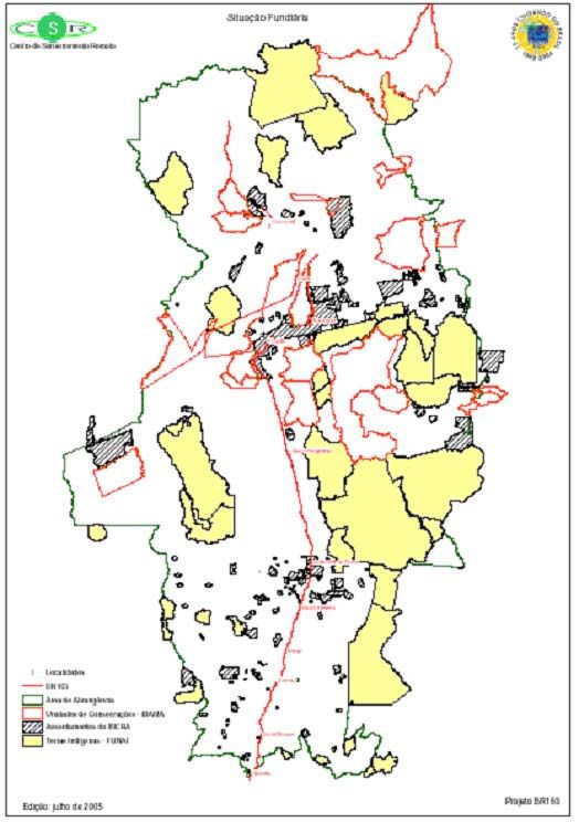
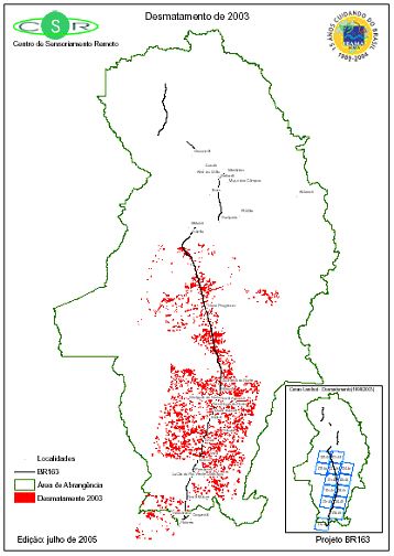
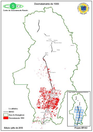
Appendix II: Supporting maps ................................................................................................ 62
Appendix III: Supporting data ................................................................................................ 65
Appendix IV: Project participants and coordinators ............................................................... 72
References ............................................................................................................................... 73
List of figures
Figure 1: Scope of BR-163 Highway .................................................................................... 14
Figure 2: Soybean production in Brazil 1952-2005 .............................................................. 16
Figure 3: Area covered with soybean crops in Brazil 2003 .................................................... 17
Figure 4: Soybean growing in BR-163 area of influence 1990-2004 .................................... 18
Figure 5: Bovine stocks 1990-2003 ...................................................................................... 20
Figure 6: Density of cattle stocks (numbers/ha) 1990-2003 ................................................... 21
Figure 7: Quantity of wood logs 1990-2003 .......................................................................... 22
Figure 8: Land use by region 1996 ........................................................................................ 23
Figure 9: Numbers and sizes of estates ................................................................................... 24
Figure 10: Average land prices by Meso-Region, R$/ha ....................................................... 25
Figure 11: GDP growth by Meso-regions 1996-2002 ........................................................... 28
Figure 12: Income distribution by sector 2003 ....................................................................... 29
Figure 13: Employment by sector 2003 .................................................................................. 30
Figure 14: Overall HDI, 1991 and 2000 ................................................................................ 31
Figure 15: Longevity HDI, 1991 and 2000 ............................................................................ 31
Figure 16: Education HDI, 1991 and 2000 ............................................................................ 32
Figure 17: Poverty levels ...................................................................................................... 33
Figure 18: Indigence levels ..................................................................................................... 33
Figure 19: Annual incidence of parasites in Brazil ............................................................... 35
Figure 20: Deforestation trends 2000-2004 ........................................................................... 37
Figure 21: A dynamic, concurrent and self-reinforcing process ............................................. 42
Figure 22: BR-163 strategies for sustainable development ................................................... 43
List of tables
Table 1: Scenario construction summary for IAP ................................................................... 11
Table 2: BR-163 area of influence by Meso-regions and Sub-areas ...................................... 15
Table 3: Gross domestic product of municipalities ................................................................ 27
Table 4: Malaria cases in Meso-Regions 1999-2004 .............................................................. 34
Table 5: Deforested area 2000-2004 ....................................................................................... 36
Table 6: Public policies and impacts ...................................................................................... 43
xiiiIntegrated assessment and planning in the context of the sustainable Amazon Plan
Table 7: Scenario construction summary for IAP (repeat) ..................................................... 44
Table 8: Scenario 1 indicators ................................................................................................. 45
Table 9: Scenario 2 indicators ................................................................................................. 46
Table 10: Scenario 3 indicators ............................................................................................... 47
Table 11: Scenario 4 indicators ............................................................................................... 49
Table 12: Synthesis matrix of scenarios ................................................................................. 51
Table A1: Soybean cultivated area (in hectare) ...................................................................... 65
Table A2: Effective bovine herd (head) .................................................................................. 67
Table A3: Bovine Herd Density (head/km2) ........................................................................... 68
Table A4: Quantity of log produced (m3) ............................................................................... 69
Table A5: Land prices (R$/ha) by types of land ..................................................................... 70
Table A6: Land price growth, by types of land ...................................................................... 71
xiv1. Introduction
In 2003, the United Nations Environment Programme (UNEP) launched “Capacity Building for Integrated
Assessment and Planning for Sustainable Development”. The purpose of this initiative was to enhance the
capacity of developing countries and countries in transition towards a market economy, and to implement
integrated assessment and planning for sustainable development with a focus on aspects such as agriculture,
poverty alleviation, environmental management and promotion of sustainable trade.
The primary methodology instrument was Integrated Assessment and Planning (IAP). The IAP tool proposes
ex ante/ex post intermediate evaluations of a planning process with a view to improve planning and later
monitoring. The ultimate objective was to facilitate inter-connections of social, environmental, and economic
levels in the planning process and in reviews of major domestic industries, thus facilitating poverty alleviation
and sustainable trade.
The IAP approach was developed by UNEP in accordance with the Millennium Development Goals. Brazil,
Colombia, Chile, Czech Republic, Indonesia, Kenya, Lebanon, Russia, Tanzania, and Uganda were some of
the countries to have developed studies under this initiative.
The central assessment theme for Brazil was the BR-163 sustainable development plan, in response to
a demand raised by the Inter-ministerial Working Group (IWG) for the Plan to integrate governmental
activities into economic development of the highway-influenced areas, between the cities of Cuiabá (state of
Mato Grosso) and Santarém (state of Pará).
Since this is a project that integrates transversally environmental, social and economic issues, the BR-163
Plan also considered the interests of the agribusiness sector and the governors of the States of Mato Grosso
and Pará. The key issue was to make infrastructure investments that were not at the expense of social
discontent (violence and poverty) and environmental damages (deforestation). Any conflicts of interest
should be mitigated by government programmes.
As the regional economies depend heavily on soybean crops, the project also assessed the mutually influencing
effects of the soybean industry and the BR-163 Plan.
In October 2004, a national integrated assessment study began. This was based on information, data
and surveys already available, covering both substantive aspects (economic dynamics, and social and
environmental impacts) and process aspects of the BR-163 Plan. On the one hand, this study examined the
interests and expectations of stakeholders using “mapping of actors”. On the other hand, for substantive
analysis, the study drew on scenario-building techniques to assess key economic, social and environmental
indicators.
Integrated assessment and planning in the context of the sustainable Amazon Plan

          A political economy approach for the study of scenarios was used, considering primordially the vectors of
          economic dynamism and state capacity to develop and implement integrated public policies.

          The study’s Final Assessment Workshop (held at Brasília on 20 April 2006) brought together segments
          of society who had raised key issues when the project started, and this clearly reflects political legitimacy
          and methodological usefulness of integrated assessment as a strategic decision-making process. Indeed,
          project outcomes contributed to the Brazilian government’s actions since it was possible now to perform an
          assessment of the environmental, social and economic dynamics. The recommended policies are being taken
          into consideration in BR-163 Plan’s feasibility process.

          1.1     Overview of the Brazilian Amazon
          The Amazon Biome can be found in nine South American countries, covering a total area of 6.4 million km².
          Brazil is home to 63 per cent of this, which is equivalent to a bit more than 4 million km². To better inform
          public policies related to the Amazon Biome, a macro region called “Amazônia Legal” (Legal Amazon) was
          demarcated in Brazil. This region covers approximately 5 million km² (which corresponds to 59 per cent of
          the Brazilian territory), and it includes: the states of Acre, Amazonas, Amapá, Pará, Rondônia, Roraima, and
          Tocantins in the north; the state of Mato Grosso; a part of Maranhão; and a small portion of Goiás.

          In 2000, the population in the Legal Amazon reached 21 million inhabitants (12 per cent of the entire
          Brazilian population), and demographic density in the region was slightly above 3 inhabitants per km².
          Demographic growth was significant over the past few years since the number of inhabitants in the region
          jumped from 8.2 million in 1970 to 17 million in 1991.

          In 2002, the Legal Amazon’s Gross Domestic Product (GDP) stood at R$82 billion (US$27.5 billion) and, at
          that time, that accounted for 6.1 per cent of the national GDP. In 2002, the GDP per inhabitant in the Legal
          Amazon was equal to R$7,400 (US$2,100), and the average GDP per inhabitant for the whole nation was
          R$12,900 (US$3,650). In 2000, the working population in the Legal Amazon was 8.5 million or 42 per cent
          of the total population in the Amazon.

          Forests (dense, open and seasonal forests) cover 64 per cent of the Legal Amazon. Non forest vegetation,
          comprised of cerrados, natural fields and campinaranas, cover another 22 per cent of the region. The Legal
          Amazon originally held 73 per cent of forest cover. By 1994, deforestation had affected 9 per cent of the
          region. By 2004, approximately 14 per cent of the region had been destroyed. This year, deforestation rate
          in the Legal Amazon was the second highest ever, affecting 27,200 km². The highest deforestation rate ever
          was reported in 1995 (29,100 km²).

          About 24 per cent of the Amazon is comprised of private areas. Another 33 per cent are legally protected
          areas - Conservation Units and Indigenous Lands. Approximately 10 per cent can be considered special
          purpose areas, such military lands, environmental protection areas (EPAs), and rural settlements. Another 33
          per cent of the Legal Amazon remain as vacant lands or private lands under dispute. The majority of legally
          protected areas in the Amazon (63 per cent) are Indigenous Lands, whereas Sustainable Use Conservation
          Units account for 6.3 per cent, and Integral Protection Units total 5.5 per cent. Special areas (10 per cent of
          the Amazon) include rural settlements (5.3 per cent) and EPAs (3.7 per cent).

          The new geography in the Amazon is not just a consequence of globalization. It is a result of an intense
          process that has been producing profound structural changes since the late 20th century (Becker, 2004). This
          transformation has two fundamental features. On the one hand, at global level, the Amazon has now become
          a new frontier of natural capital whose territorial appropriation is supported by scientific and technological
Introduction

use of nature and, on the other hand, at domestic level, it is no longer the major frontier of economic and
population expansion, thus exhausting the old standard of the Amazon as a mobile forest, but rather has
become an area with significant potential for development as well.

Recent regional history has brought significant changes to the pattern of settlement based on river
transportation. The pattern of territorial integration (both terrestrial and fluvial) kept a peculiar linearity
by following the river, along which investments (both public and private) and demographic flows have
come to be concentrated, thus creating a specific regional macro zone system. Man-induced pressures of
deforestation and burns, and the serious conflicts over land do not exist 100 kilometers from these belts of
river or roads.

Intensification of roads is especially pronounced east of the states of Pará, Maranhão, Tocantins, Mato
Grosso, and Rondônia, making up a great arc of settlement along the forest rim and a 3,000-5,000 km wide
belt. This great arc of settlement was the main expansion area of territorial settlement in the Amazon. For
decades, economic expansion depended on timber exploitation-deforestation-burns-cattle raising to open
new spaces, which explains the name Arc of Fire.

The mobile frontier of the Amazon may have given way to individual fronts of expansion (Becker,
2004), which are mainly located in the following areas: (a) Cuiabá-Santarém road and in Mato Grosso’s
municipalities of Alta Floresta, Guarantã do Norte, Castanheiro, and Aripuanã; (b) Porto Velho-Manaus
road; (c) Santarém-Itaituba-Altamira-Almerim área; (d) state of Pará’s municipality of São Félix do Xingu;
and (e) state of Rondônia’s municipality of Buritis. The overall state of deforestation, after 2000, tends
to be concentrated on already deforested border areas, and recent data seems to indicate new trends and
processes that make the current picture more complex. Intensification of expansion fronts is driven primarily
by soybean competitiveness and the expected installation of new transport axes. These recent expansion
fronts are of a different type than the original fronts in the 1960s and 1970s, since they no longer revolve
around a policy of incentives by the Government, but depend on the resources of economic actors primarily
based in Cuiabá and Belém (Becker, 2004).
2. State planning processes

In the Amazon, several planning processes are underway, and some plans end up overlapping due to the
way such processes are started off. The most overarching, however, is the Pluriannual Plan (PPA), under
which all government investment programmes for development purposes are grouped. It is financed with
funds from the Treasury, including investments made by states and municipalities. In addition to the PPA,
decisions to start a regional or thematic planning process are made in order to channel public or private
investments into strategic areas. In the case of the Amazon region, some of these processes overlap spatially,
though they have different overall objectives, including:

1. Sustainable Amazon Programme
2. Action Plan for the Prevention and Control of Deforestation in the Legal Amazon
3. Sustainable Regional Development Plan for the area under the influence of the BR-163 Cuiabá-Santarém
   Road – BR-163 Plan.

Brazil is a federal country and its policies are decentralized. States and municipalities have relative autonomy
to pursue their public policies, including those related to land use and natural resource planning. This is why
the implementation of integrated policies, such as recommended assessment processes, can be challenging.

2.1     The Pluriannual Plan
The Pluriannual Plan (PPA) is a constitutional provision that delegates to the Federal Government the
medium-term planning of fundamental issues, such as encouragement to production, job creation, reduction
of regional inequalities, better infrastructure, technological and scientific development, human development
and social inclusion as income distribution is perfected. The Government must submit the PPA to the
parliament by the end of August in the first year of administration.

Through this broad strategy and in line with a medium term planning process, PPA is a reference for other
processes. This is the case of the Sustainable Amazon Programme, where the inputs for planning are derived
from the guidelines and investments contained in the PPA.

The 2004-2007 Plan is committed to macroeconomic stability preservation. It estimates economic growth
rate at above 4 per cent per year and recognizes that investment levels in infrastructure over the past few
years have had an adverse effect on Brazil’s competitiveness, in particular from high transportation costs.
The conclusion is that substantial investments are necessary to expand and recover the transport network in
order to support long term economic growth.
Integrated assessment and planning in the context of the sustainable Amazon Plan

          2.2         The Sustainable Amazon Plan
          The Sustainable Amazon Plan (PAS) is a host of guidelines developed by the Federal Government in
          collaboration with the states in the region. The PAS is a reference document for the Amazon. It is also
          innovative, since it is the first initiative to outline actions of several Ministries in a shared development
          strategy for Amazon, and since it seeks interaction between federal and state levels of government.

          It proposes to integrate public policy instruments with a view to implementing a new development model
          based on five thematic areas:

          •       Environmental management and land use planning
          •       Innovation and competitiveness-based sustainable production
          •       Social inclusion and citizenship
          •       Development-oriented infrastructure
          •       New financing standard.

          The PAS is not in itself an action plan. Rather, it is a framework of theories, directives and a set of strategies
          and action lines for policies and planning processes, with consideration for societal participation in the
          discussion and elaboration of projects. It encompasses the Legal Amazon, and its directives are a reference
          for the BR-163 Plan.

          2.3         Permanent Inter-ministerial Workgroup
          As the deforestation growth rate went up by 40 per cent during the 2001-2002 period (INPE, 2004), the
          Federal Government decided to create a committee to look into reducing deforestation rates in the Amazon
          while ensuring sustainability and quality of life for the population. In view of this challenge, a Presidential
          Decree of 7 March 2003 established a Permanent Inter-ministerial Workgroup (GPTI) that would propose
          measures and coordinate actions for the reduction of deforestation rates through the following instruments:

          •       Land use planning and legalization of land tenure in the municipalities in the Arc of Deforestation
          •       Fiscal and credit incentives to expand economic efficiency and sustainability of areas already
                  deforested
          •       Procedures for environmentally sustainable infrastructure works
          •       Job and income generation in activities with rehabilitation of degraded areas
          •       Addition of open and abandoned areas to the production chain, and management of forest areas
          •       Integrated performance of federal agencies responsible for monitoring and control of illegal activities in
                  the Arc of Deforestation
          •       Others that may be considered relevant.

          The GPTI is coordinated by the Office of the Chief of Staff, and is comprised of 11 Ministries, including those
          in charge of Agriculture, Defense, Science and Technology, Agrarian Development, National Integration,
          the Environment, Mines and Energy, Justice, Transportation, and Labour. However, besides institutional
          constraints, budget restrictions and limited reach of official economic services and instruments lessen the
          effect of policies, even when they are well formulated.

          2.4         The BR-163 Plan
          To manage the area of influence of BR-163 highway, the Brazilian Government has begun to harmonize
          interests into integrated actions that can mitigate socio-environmental impacts due to road paving. Without
          a consistent plan, paving “could exacerbate undesirable social and environmental impacts in its influence
          area” (PAS, 2006).
State planning processes

The BR-163 Plan is “the first experience of formulation of an operational plan for an area in Legal Amazon
based on PAS general directives” (PAS, 2006). The area of influence crosses 73 municipalities (28 in Pará
state, 39 in Mato Grosso state and 6 in Amazonas state) and will be 1,232,000 km² in total area, or 14.7
per cent of total territory. Hence the highway, in its Cuiabá-Santarém segment, crosses “one of the most
important regions in Amazon, from the point of view of economic potential, biological diversity, natural
wealth and cultural and ethnic diversity” (BRASIL, 2005).

The new highway will benefit Mato Grosso, the largest soybean grower and exporter in the country, but will
also be strategic as it will reduce transport costs for transport to the ports of Paranaguá (PR) and Santos (SP).
Electronic products from Zona Franca de Manaus, meat, timber, and agro-forestall products, in addition to
soybeans, will be the main cargo.

The area of influence covers a large mosaic, including pristine areas and deforested areas. The mere
expectation of concluding the paving of this BR-163 road segment has been contributing to accelerated
processes of disordered land occupation and predatory exploitation of natural resources (BRASIL, 2005).

2.4.1 BR-163 Plan creation
The BR-163 Plan is under the responsibility of an Inter-ministerial Working Group (IWG), decreed by
a President’s Act on 15 May 2004. It is coordinated by the Presidency’s “Casa Civil” and comprises of
21 organizations from the Ministries and Presidency’s “Casa Civil” and Secretariats. It has created four
thematic working groups (WGs), made up of experts from Ministries and public organisations.

In the Plan building process, 15 city consultations were carried out in the region, (seven cities in the first
round and eight cities in the second round), aiming to collect suggestions from the different social groups
likely to be interested, such as state governments, municipalities, entrepreneurs and workers representative
entities, civil society forums, etc. The Plan’s strategy towards sustainable regional development is to tackle
poorly synergetic relationships among the stock of natural resources, to raise job and income creation, and
to improve governance in the Amazon, the so-called “frontier economy”. The objective is to bring about a
more balanced scenario, such as sustainable exploration of natural resources so as to generate income and
employment and to foster increasing levels of governance.

The assumption here is that large scale works, such as the paving of a highway of this size, triggers economic
growth in the region, but also causes conflicts that should be arbitrated by the State by facilitating new
production systems, in addition to upholding the rights of indigenous populations and other traditional
populations. Land use planning has prompted planners to demarcate new conservation units, adopt a
timber certification system, and to create a thriving production sector based on bio-prospecting and the bio-
industry.

2.4.2 Action strategies
There are four strategic axes for investment policies and strengthening governmental institutions. They are:

1. Land use planning and environmental management, which include consolidation of occupied areas on a
   sustainable basis; sustainable use and protection of forests; land tenure legalization; land development at
   local and micro-regional level; economic and ecological zoning; environmental monitoring and control;
   and improving urban centres.

2. Encouragement to productive activities. The planners assumed that it was possible to strike a balance
   between development-oriented actions and forest conservation actions. Encouragement policies are
Integrated assessment and planning in the context of the sustainable Amazon Plan

                  focused on the use of credit instruments, technical assistance, and scientific and technological research.
                  Policies include: local productive chains and productive arrangements (APL); strengthening of family-
                  based production; sustainable use of forests; solidarity economy; ecological tourism; development
                  promotion instruments.

          3. Development-oriented infrastructure, with various investments to improve the transportation system,
             integrate a multi-modal system, evaluate the network of informal roads and integrate transportation
             on waterways; invest in the energy system, with incentives to biomass energy production; improve
             communications systems; and improve storage systems.

          4. Social inclusion and citizenship. The social inclusion strategy intends to disseminate universal policies
             regarding education, health and public security; accelerate the fight against poverty; community
             development, etc. Another objective is to prevent poor rural populations from being chased away from
             their territories.

          2.4.3 IAG analysis of the BR-163 Plan
          Even as the BR-163 Plan was being drawn up, analysis and criticisms on the proposition were published
          from 2004. One of these was made by the International Advisory Group (IAG), a group of experts that
          annually evaluates the results of the pilot programme PPG7 to conserve the Brazilian rainforest.

          The highlights of the IAG assessment on BR-164 Plan are as follows:

          •       Disparity exists between the slow pace of governmental initiatives and the acceleration of the land
                  occupation process. The lack of trust in the capacity of the State to act may result in civil disobedience.

          •       Lack of consensus to make the PAS viable and problems in implementing initiatives to prevent and
                  control deforestation in the Legal Amazon are continuing.

          •       Lack of clear indications on how to connect the licensing procedure of the BR-163 Highway and the BR-
                  163 Sustainable Plan.

          •       Important inputs and capital from PPG7 should offer an opportunity to experiment with newer and more
                  advanced ideas than the BR-163 Plan.

          •       Given the worsening land relations in the area of influence, proposed initiatives to address this issue
                  would be insufficient. IAG suggested measures to give priority to tax collection and public land
                  registration, which would involve the Federal Public Property Secretariat. In addition, they suggested:
                  (a) the legalization of land possessions of up to 100 hectares; and (b) legalization of land possessions of
                  over 100 ha that do not superimpose in the range of up to 30km.

          •       Amazon electric power portfolio is still being assembled from lobbying by interest groups, instead of
                  being selected from the Pluriannual Plan.

          •       The need exists to recognize the value of environmental services in the Amazon, with the accelerated
                  generation of knowledge chains that become productive chains, such as bio-industry. The IAG supported
                  a scientific and technological revolution for the Amazon, including the area under the scope of the BR-
                  163 highway.
State planning processes

2.4.4 Stakeholders in the BR-163 Plan
Two rounds of public consultations were held to identify the demands and expectations of local participants
of the Plan. The first round of consultations was held in July 2004 in Santarém, (2 and 3 July), Altamira (5
and 6 July), Novo Progresso (8 and 9 July), Guarantã do Norte (12 and 13 July), Sorriso (15 and 16 July),
and Apuí (19 and 20 July). On 27 July, a public consultation was held in Brasilia on the request of NGOs
and civil society. The second round of public consultations was held in April and May 2005. In this round
the most remarkable absence was the indigenous populations, who did not attend since it was difficult for
them to reach the meeting venues and because the planners had promised an exclusive round of meetings for
them, but which was not held.

The history of land occupation in the area shows that indigenous populations are major losers from land
appropriation processes. Up until the 1940s, the territories in the west of Pará and mid-north of Mato Grosso
had significant indigenous presence. In Pará, the main indigenous peoples living in the region were the
Panará, Kayapó, Kube-Kra-Noti, Yuruayá, Kuruáya, Sipayá, Munduruku, Guahuara, Arara, Yuruna, Sipáy,
and Maué. And in Mato Grosso the main indigenous peoples living in the region were the Bororo, Bakairi,
Kayabi, Suiá, Manitsauá, and Panará (Kren-Akarore).

Grabbing of indigenous lands was explicitly a component of the land occupation process in the north of
Mato Grosso, which received support from agricultural projects encouraged and funded by the Federal
Government. Indigenous lands were violently grabbed by speculators based on forged documents attesting
that they were not Indians or even squatters (Oliveira, 2005). As a result, gigantic rural properties in the
region were established.

For the second round of consultations, one hundred representatives were interviewed. These people lived
in 22 towns in the BR-163 area of influence, and were associated with 75 institutions, organizations and/or
social movements in the region. The survey has clearly mapped the response of these representatives on the
highway paving:

•   85 per cent of the interviewed believed that BR-163 would be paved in a period between five and ten
    years.

•   25 per cent believed that items provided for in the Plan would be implemented together with the highway
    laying.

•   Slightly over half expected that only 50 per cent of the initiatives of the Plan will be implemented within
    five to ten years. The rest thought that over 50 per cent of the initiatives would be implemented.

•   10 per cent of the interviewees thought the paving should only take place with the full implementation of
    the initiatives provided for in the Plan. The majority of these belong to civil society.

The survey has clearly evidenced some disbelief of the interviewees. Although there is a majority of opinion
that favoured the participation process currently promoted, a mix of trust and disbelief prevailed over future
governmental policy.

On the results of the implementation of the BR-163 Plan, expectations in general were highly positive. Those
who lived in the towns and cities located along the highway in particular gave more importance to economic
expansion that the environmental features included in the Plan. The general conclusions are:
Integrated assessment and planning in the context of the sustainable Amazon Plan

          •    No one was against the paving. Some favoured it without conditions. Some favoured it with
               reservations.

          •    Most of the reservations were presented by the civil society group.

          •    Expectations linked highway paving with expected benefits from best distribution of production (30 per
               cent of interviewed), facilitated access to public services (17 per cent) and increased job opportunities
               (13 per cent).

          •    Local governments and the private sector had least expectations of problems and proposed the least
               solutions.

          •    Migration, the increase of violence and crime, environmental devastation, and the difficulties of access
               to land were the issues most frequently seen as important ones.

          •    Problem perception varied according to representatives evaluated. Environmental issues are most
               frequently mentioned by civil society and those connected with the Federal and State Governments.

          •    NGOs most frequently raised contentions raised against state and local governments, loggers, urban
               entrepreneurs and urban workers. The most explicit disputes were related to foreign NGOs. The frequency
               with which the disputes with the Federal Government were mentioned by large-sized farmers and also by
               urban and rural workers was also significant.

          •    The Federal Government was often mentioned as the actor from whom the most effective participation in
               the region was expected. However, INCRA and IBAMA were often described as inoperative, ineffective,
               bureaucratic and corrupt.

          •    Approximately half of the actors surveyed stated that the process would improve if decision-makers
               listened to the people and institutions that most contributed to it and if it bridged the uncertainties in
               the hearings carried out so far. The most frequently mentioned gaps were the concerns of the native
               communities, the rural workers and the small-business owners.

          2.5      IAP’s contribution
          The main contribution of the IAP project lies in offering the planners a set of political recommendations,
          prepared through integrated assessment of the Plan and specific methods used to evaluate planning procedures.
          The methods consist of studying its substantial and procedural aspects, and using environmental, social
          and economic indicators appropriate to key issues in the understanding of the regional processes. Potential
          scenarios are then built.

          Construction of the three scenarios initially proposed by UNEP’s experts – (a) without the Plan, (b)
          with emergency investments, and (c) with structural investments – was slightly changed to include the
          economic dynamism criterion. Social and environmental indicators have proved sensitive to it. The fall in
          the deforestation rate for example was partly linked to the demand crisis in the soybean sector. Therefore,
          economic dynamism, which is called level of market activity (LMA) here, is considered a determining factor
          in the construction of scenarios.

          The possible scenarios are discussed at length in Chapter 4 but a summarized model is shown in Table 1.

              10
You can also read