Pathways Plan 2021 Update

       2021
←
→
Page content transcription
If your browser does not render page correctly, please read the page content below
Pathways Plan 2021 Update
2021
Town of Wilton
      Open Space, Recreation and Pathways Plan 2021 Update
                                     Town of Wilton
                               Saratoga County, New York
                                     22 Traver Road
                                Wilton, New York 12831
                                     (518) 587-1939

                      Prepared for the Wilton Town Board:

                                  John Lant, Supervisor

                           John McEachron, Deputy Supervisor

                              Duane Bogardus, Councilman

                              Erinn Kolligan, Councilwoman

                             Raymond O’Conor, Councilman

                                     Prepared by:

                               The Open Space Committee

           Linda Baker, Margo Olson, Raymond O’Conor, and Ryan Riper, P.E.

                  Town of Wilton Department of Parks and Recreation

Special thanks to Larry S. Gordon for his insight and guidance on the plan and his years of
                         dedicated service to the Town of Wilton.

                               Assistance Provided By:

  In every walk with nature one receives far more than he seeks.
                           - John Muir
TABLE OF CONTENTS

EXECUTIVE SUMMARY i

SECTION 1 OVERVIEW 1-1

SECTION 2 COMMUNITY SETTING 2-1

SECTION 3 OPEN SPACE, RECREATION AND PATHWAYS 3-1

APPENDICES
EXECUTIVE SUMMARY

Scenic vistas, exceptional habitats for threatened and endangered species (including the Northeast's
largest population of the Karner blue butterfly), many miles of established trails and significant
opportunity for increased pathway connectivity, and vibrant outdoor recreational spaces provide a rich
natural environment for the Town of Wilton's residents and visitors.

The Town of Wilton continues to grow, a trend that has fluctuated but remained positive each decade
since 1930. The Capital District Regional Planning Commission (CDRPC) projects the population of the
Town will continue its growth from 16,173 in 2010 to 19,652 in 2030, a change of nearly 22 percent. This
population change gives the Town of Wilton the largest projected growth in the next decade of any
municipality in the county.

This prediction indicates that the large demand for additional housing will likely continue and result in
the conversion of open space lands to residential uses unless there are more effective strategies in place
to protect these areas. The town’s natural landscapes are an attractive resource for the increasing
number of young adults and families as well as the populations nearing retirement age.

With the projected population changes in both overall numbers and makeup, it is vital that the Town of
Wilton moves forward this plan’s recommendations to not only ensure that open space and agriculture
land are protected, but that the changing recreational needs of the town are met as well. This plan is
broken up into three main concerns for the town: Open Space, Recreation, and Pathways.

This Action Plan summarizes findings, goals and necessary action steps to accomplish the goals detailed
in the 2021 Update to the Town of Wilton Open Space, Recreation and Pathways Plan (OSRPP). The
OSRPP update is the fulfillment of one of the priority recommendations from the Town of Wilton
Comprehensive Plan adopted in 2004 and updated in 2015. With many changes occurring in the Town
since the 2007 adoption of the OSRPP, an update was warranted and commissioned by the Town Board.
The purpose of the OSRPP update is to establish a strategy for the preservation of the diverse
agricultural, historical, recreational, and scenic open space lands that strongly influence the quality of
living in the Town of Wilton. The residents of the community, through expression in the adopted
Comprehensive Plan, have acknowledged and endorsed the role of open space and the contributions
these resources make to daily life in the Town. A balanced approach to future use of land in the Town is

                                                    i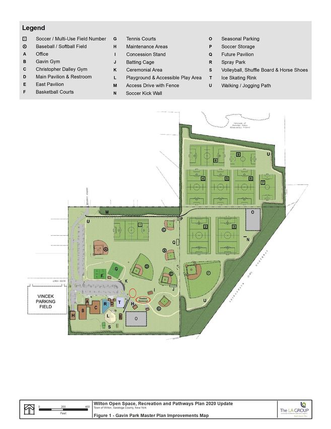
important and proper and appropriate measures implemented now will allow for managed growth and
preservation of the Town’s natural resources in the future.

The intent of the OSRPP update is to provide a means of connecting open space areas, residential areas,
recreation areas, service providers, Town services, and commercial areas with a town-wide system of
pathways that allow for multiple forms of transportation to move effectively throughout the Town. The
system will also have public health and quality of life benefits by providing opportunities for exercise,
recreation, and connections with the natural world.

Through public outreach efforts, the OSRPP update incorporates the concerns and hopes of this
community to establish a vision to guide future planning and development in the town. The plan reflects
a history of commitments to protect open space and historic resources and expand upon a variety of
active and passive recreation opportunities through building upon the successes of previous planning
initiatives at the local, regional, and statewide levels.

A Commitment to Open Space, Connectivity and Recreation
Since its formation in 1818, the Town of Wilton has shown strong commitment to enhancing and
preserving open space, recreational venues and pathways. Significant efforts to identify and protect
open space, recreational venues and pathways over the past several decades, demonstrates the Town’s
commitment to its open space and recreational resources and the connections between them. The most
significant efforts include:
▪   Improvements to the Subdivision and Zoning Regulations and inclusion into the Town Code,
    including adoption of a Conservation Subdivision Design Ordinance (CSD);
▪   Continued Implementation of the Master Plan for Gavin Park;
▪   Continued updates of the town-wide multi-use trail system; and
▪   Continued financial support for WWPP.

The OSRPP is directly supported by public comments made during the development of the 2015 Town
Comprehensive Plan and is closely associated with other recent open space preservation and recreation
planning efforts. To oversee the this update, the Town appointed an advisory committee consisting of
Town Board members, town officials and residents. They were instrumental in the plan development
process including formulating strategic actions to achieve the desired results of permanent preservation
of natural resources and unique features.

Goals for Open Space
Open space is a broad and complex consideration. Within the context of the preservation goals for
Wilton, open space refers to natural terrestrial features such as meadows, steep slopes, forested areas;
aquatic features including lakes, streams, ponds, and wetlands; heritage areas including historic
landmarks and buildings; geological features including hydric soils and aquifer recharge areas, vernal
pools; and consideration of scenic views. The values of open space are as diverse as the types of open
space listed above.

Preservation of open space is especially important considering the presence of the Saratoga Sand Plains
ecosystem in the Town of Wilton. Management efforts benefit a number of species including the Karner
blue butterfly, Frosted elfin butterfly, Blanding’s turtle, Persius duskywing butterfly, hognose snake,
spadefoot toad, blue spotted salamander, and other species identified by the NYS Department of
Environmental Conservation (DEC) as being Species of Greatest Conservation Need.

                                                   ii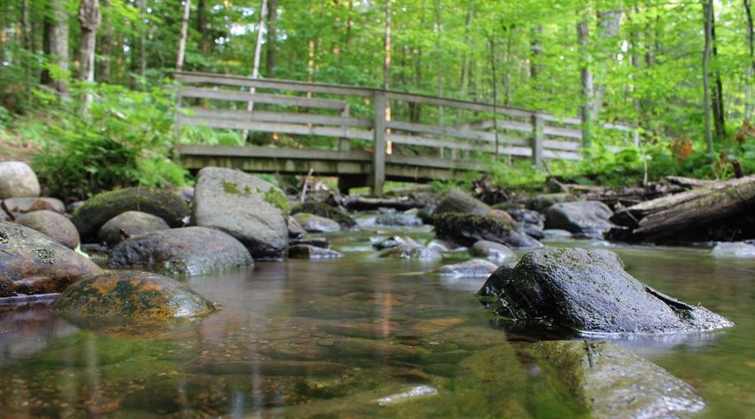
Open space conservation is addressed through the Town’s environmental and land use regulations. The
Town’s conservation subdivision law requires developers to utilize a conservation approach when
subdividing lands of 10 or more lots. Open space on either along the Adirondack Northway is protected
from development through the Northway Corridor Overlay District (NCOD). Natural areas and their
timber, soil and streams are managed and protected by the Town’s Timber, Soil and Stream Regulations.

Goals for Recreation
The Town has a significant number of pre-school and school-aged children. According to the 2010
Census, approximately 27 percent of the Town’s population is 19 years of age or younger. This statistic
indicates a strong need for recreation facilities of both an active and passive nature. Furthermore, it is a
stated goal of the Town’s Comprehensive Plan “to provide sufficient opportunities and facilities for both
active and passive recreation activities.” Active recreation includes types that require support
equipment and facilities such as fields, courts, or tracks for the conduct of an organized game or match.
Passive types are activities that are less reliant on structured facilities or competitions and include
walking, jogging, trail running, dog walking, on and off-road cycling, hiking, snowshoeing, skating, cross
country skiing, fishing, hunting, and bird watching.

Goals for Pathways
OSRPP envisions a town-wide system of pathways that effectively links open space areas, residential
areas, recreation areas, points of interest, service providers and commercial areas. The strategy relies on
a long-term, phased approach to piecing the links together through timely consideration during the
development review process and optimal use of relevant state and federal transportation and funding
programs. When complete, the Town’s trail system will have meaningful connections to residential and
commercial areas via multiple and alternative transportation routes affording seasonal access and
movement for walkers and bicyclists.

Recommendations and Action Steps
The Town of Wilton Comprehensive Plan 2015 Update established a general town-wide goal ”to
conserve, improve, and protect our Town’s natural resources, viewsheds and open space including
wildlife habitat, that contribute to the diversity, character, aesthetics, environmental quality, economy,
and general health, safety and welfare of the community.” The OSRPP update outlines actions for the
Town to implement to accomplish this goal. The Town worked with the community and its partners to
identify the highest priority actions for open space, recreation and pathways in Wilton. The Town of
Wilton Comprehensive Plan 2015 Update also provided a set of recommendations for specific planning
areas throughout the community. The 2015 update was adopted by the Open Space Committee and
incorporated into the following recommendations and action steps.

Open Spaces
1. Continue to identify areas of the Town landscape that are suitable for open space preservation. The
   areas identified should be based on prioritized considerations that reflect the public’s enjoyment
   and ecological function of the space preserved.

2. Review and update existing Town regulations (i.e. zoning, site plan, subdivision) as necessary to
   achieve a balance between the adequate protection of resources and the fiscal and social needs of
   the Town and its residents. Evaluate potential land preservation mechanisms such as easements,
   land acquisition, purchase of development rights, and the use of incentive zoning to achieve the

                                                     iii
transfer of development rights. Utilize incentive-based tools for open space preservation coupled
   with regulatory measures implemented through zoning, development guidelines, and a conservation
   development subdivision review process.

3. Develop a management strategy to inventory and catalogue all open space parcels for the Town.
   Develop a single form to inventory the existing open space parcels for their recreation and
   environmental education potential. Consider the required investment, desired uses and activities for
   open space lands, specific attributes and constraints of existing open space areas, appropriate
   management techniques, funding available, and human resources available to undertake
   management of the parcels inventoried and catalogued.

4. The Town should accept open space parcels that are being offered for donation, based on a
   thorough review by the Planning Board and Town Board. In many cases a parcel offered or to be
   acquired by sale or donation may involve one an organization such as Saratoga PLAN, the Open
   Space Institute, Wilton Wildlife Preserve & Park, or some other entity.

5. Consideration of fee simple purchase of lands or easements should be made on a case-by-case basis.
   Once a determination has been made that the parcel under consideration meets the criteria for
   priority open space, a method for owning, managing and financing the acquisition must be
   established prior to the final decision on acquisition. Factors to consider include cost, method of
   funding, means of ownership, the cost of upkeep, the approach to maintenance, and the long-term
   source of funding to cover maintenance and management costs.

6. Ensure enough funds are budgeted for existing and continuing program and land management.
   Furthermore, it is recommended that multiple funding sources be prioritized and pursued. Priority
   should be given to applying for available federal, county and state programs. As a next priority,
   private donations to fund preservation efforts would be possible.

7. Implement protection options as easements, tax abatements, transfer of development rights, and
   purchase of development rights programs, incentive programs, outright purchase, and other funding
   mechanisms.

8. Encourage existing farms to take part in agricultural protection programs in Saratoga County
   through the Purchase of Development Rights (PDR) Program and other resources such as the USDA
   and NYS Department of Agriculture.

Water Resources
9. Adjust the stream corridor buffer standard to be measured from the shoreline, rather than the
   center of the waterway. This will add a more defining measuring point and increase the amount of
   protected areas. Standards should focus on the quality of the stream corridor, steepness of the
   slope, conditions which may contribute to erosion, and habitat value. Buffers and lot clearing
   restrictions around areas with physical constraints may be warranted and should be established on a
   case-by-case basis.

10. Review the Stream Corridor Overlay District requirements and update as necessary to work toward
    protecting the integrity of natural stream systems to the maximum extent possible. Incorporate
    these protections as necessary into site plan and subdivision regulations.

                                                  iv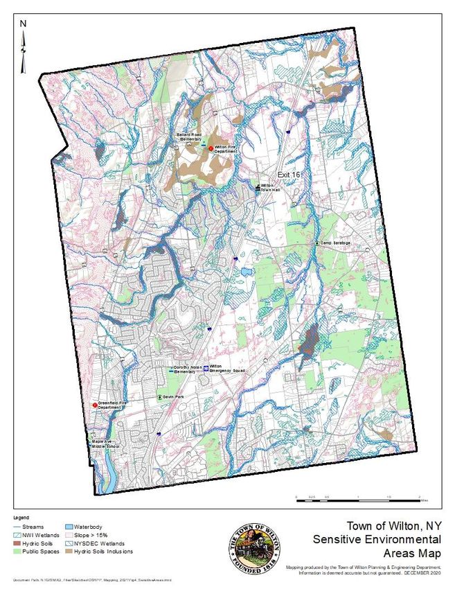
11. Minimize the potential impacts of erosion and sedimentation through strict compliance with the
    most recent State Pollutant Discharge Elimination System (SPDES) General Construction Permit
    requirements for stormwater management and pollution prevention.

Scenic Resources
12. Identify, map and protect high-quality scenic resources.

13. Utilize Visual Overlay Districts for highly sensitive areas to address road setbacks, cut and fill,
    lighting, reflective glass, height, structures that could be considered intrusive such as billboards or
    cellular towers, and site layout/design.

14. Require through site plan review and SEQR that all projects describe the potential impact on any
    locally significant visual resources that are identified in this document. During the site plan review
    procedure for review of commercial and industrial projects the Planning Board should utilize best
    practices to lessen the visual impact including screening, relocation on site, disguise, low profile, and
    sensitive lighting. The Zoning Board of Appeals should utilize similar standards in the review of
    variances, particularly variances relating to signs.

15. Improve compliance with the Northway Corridor Overlay District. The intent is to protect natural
    areas on either side of the Northway from development. A set of compliance guidelines should be
    compiled and imposed during subdivision and/or site plan review by the Planning Board. These
    guidelines should include realistic enforcement and penalties with requirements for rehabilitation,
    reclamation, and restoration of said lands.

Recreation
16. Support ongoing projects at Gavin Park. Consider additional locations for recreation.

17. Establish minimum recreation facility standards for active and passive recreation related to the size
    of individual development projects.

18. Complete a long-range plan for a compatible but diverse set of outdoor recreational uses at Camp
    Saratoga.

19. Consider implementing and supporting bike parks and multi-use areas.

Pathways
20. Invest in a clear and simple comprehensive all-season trail map for visitors. Identify all Town parks,
    WWPP and Saratoga PLAN trail preserves, state land trails, and county trails. Include length of time
    for the hike, the level of difficulty, and appropriateness of the trail for different ages and abilities.
    Illustrate the extent of the trail system, rules and regulations, and the location of different types of
    trails and attractions.

21. Create a standardized informational, wayfinding and interpretive signage plan that makes it simple
    for people to find and navigate local trails.

22. Develop standards for the design of trailheads. Incorporate parking and trail registers where
    appropriate.

                                                     v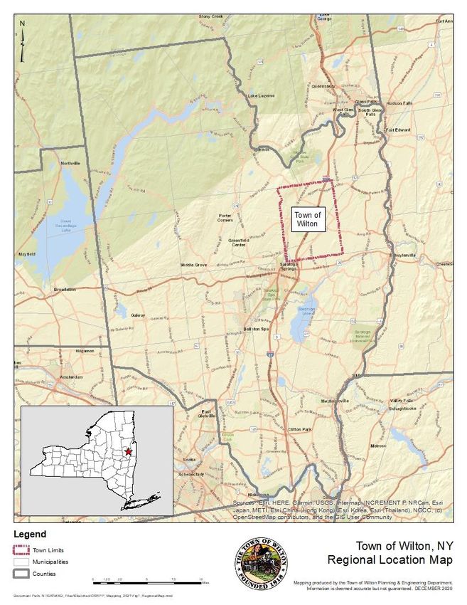
23. Negotiate access agreements with property owners at key connectivity points, and to trail
    destinations such as open space, park, and recreation lands with future connections to destinations
    such as schools, shopping areas and employment centers.

24. The powerline owned by National Grid located on the east side of Route 9 has potential to be a part
    of the interconnected Pathway. It was an original potential Saratoga County “Heritage Trail” and is
    being mentioned once again as a possible connector for the Sarah B. Foulke Friendship Trails
    system.

25. Develop use and safety guidelines and regulations for trails throughout the Town and conduct a
    public outreach and education program to advise Town residents.

26. Adopt a trail management strategy for off-road trails. A trail use ordinance could help the trail
    managing agency protect trails. The ordinance should contain the rules and regulations of the trail
    system and should be posted at trailheads. It is recommended that the standards for municipal
    trailheads be compatible with the standards of the State Department of Environmental
    Conservation.

27. Consider and prioritize paving projects to improve on-road connections to trail.

28. Establish and adopt a detailed plan for on- and off-road connections adjacent to Northway crossings.

29. Consider use of park and recreation fees for maintenance of Town trails.

30. Require private developers to connect future subdivision and residential development plans to
    trails.

Wilton Wildlife Preserve & Park
31. Support the WWPP and its mission. Ensure that actions relating to land use at the local and regional
    levels are consistent with the program’s identified goals.

32. Continue compliance with NYS DEC and other state and federal standards, regulations and
    requirements for projects located within the WWPP to ensure protection of critical habitats and
    resources.

                                                    vi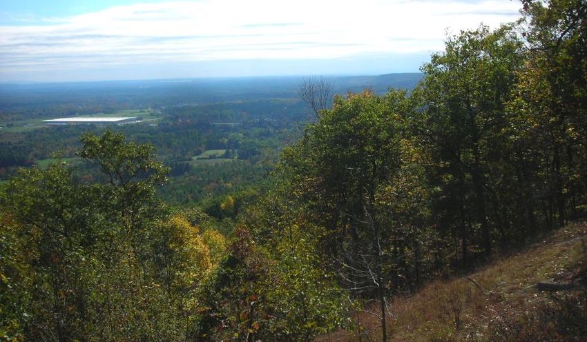
vii
SECTION 1               OVERVIEW

1.1     Open Space, Connectivity and Recreation for Future Generations
The Town of Wilton Open Space, Recreation and Pathways Plan Update (OSRPP) is the fulfillment of one
of the priority recommendations from the Town of Wilton Comprehensive Plan adopted in 2004 and
updated in 2015. With many changes occurring in the Town since the 2007 adoption of the OSRPP, an
update was warranted and commissioned by the Town Board.

The purpose is to establish a strategy for the preservation of the diverse agricultural, historical,
recreational, and scenic open space lands that strongly influence the quality of life in the Town of
Wilton. The residents of the community, have acknowledged and endorsed the role of open space and
the contributions these resources make to daily life in the Town. A balanced approach to future use of
land in the Town is important and proper and appropriate measures implemented now will allow for
managed growth and preservation of the Town’s natural resources in the future.

The intent of the OSRPP is to provide a means of connecting open space areas, residential areas,
recreation areas, service providers, Town services, and commercial areas with a town-wide system of
pathways that allow for multiple forms of transportation to move effectively throughout the Town. The
system will also have public health and quality of life benefits by providing opportunities for exercise,
recreation and connections with the natural world.

Wilton's Physical and Organizational Landscape
Although most of the town has flat or gently sloped
terrain, the approximately 36 square miles of the Town
includes Palmertown Ridge in the northwest part of town
as well as mountain views to the east and northwest. Two
small lakes, several ponds, and a proliferation of streams
highlight the town’s water resources. While the southern
and western portions of the town are notable for their
extensive housing and business development, there are
large areas of open space in the eastern and northern
sections.

Gavin Park offers fields and facilities for community                      Palmertown Ridge

                                                   1-1
events, organized group sports and other active recreation. Camp Saratoga is a former Boy Scout camp
now used for passive recreation and environmental education and serves as the main entry to the
Wilton Wildlife Preserve and Park, Inc (WWPP). Land parcels owned by the Town of Wilton, the County
of Saratoga, The Nature Conservancy, and the State of New York are included in the geographical area of
the WWPP, which extends thousands of acres east of Interstate 87 (the Northway). These protected
lands are part of the geologically significant Saratoga Sandplains, an area of ancient sand dunes,
important wetlands, and diverse ecological communities encompassing several endangered and
threatened species. The existing trail system features many miles of walking, running, biking, horse-
riding, snowshoeing, and cross-country skiing access to many of these notable natural features.
Wilton's Unique Environment for Open Space, Pathways, and Recreation
Scenic vistas, exceptional habitats for threatened and endangered species, many miles of established
trails and significant opportunity for increased pathway connectivity, and vibrant outdoor recreational
spaces provide a rich natural environment for the Town of Wilton's residents and visitors.
Open Space
Open space is a broad and complex consideration. Within the context of the preservation goals for
Wilton, open space refers to natural terrestrial features such as meadows, steep slopes, forested areas;
aquatic features including lakes, streams, ponds, and wetlands; heritage areas including historic
landmarks and buildings; geological features including hydric soils and aquifer recharge areas, vernal
pools; and consideration of scenic views. The values of open space are as diverse as the types of open
space listed above.
Open spaces, while enjoyed for their characteristics of
serenity, airiness, and tranquility also serve as habitat for
a variety of wildlife and vegetation. The physical setting
and climate are supportive of a varied mix of amphibians,
reptiles, birds, fish, trees, shrubs, and groundcover. The
recommended strategy identifies areas that meet these
criteria as well as methods for preserving these lands and
features over the long-term. Preservation of open space is
especially important considering the presence of the
Saratoga Sand Plains ecosystem in the Town of Wilton. Farmland and open spaces: Multiple benefits
This unique ecosystem supports the endangered Karner because they protect scenic views, arable land, and
important ecosystems.
blue butterfly, frosted elfin butterfly and Blanding’s turtle,
the hognosed snake, Persius duskywing butterfly, and other species identified by the NYS Department of
Environmental Conservation (DEC) as being Species of Greatest Conservation Need.
Recreational Opportunities
The Town has experienced a considerable increase in population. This is true both in comparison to past
trends in population increases in the Town as well as comparison to similar towns in the region. As a
result, the Town has a significant number of pre-school and school-aged children. According to the 2010
Census, approximately 27 percent of the Town’s population is 19 years of age or younger. This statistic
indicates a strong need for recreation facilities of both an active and passive nature. Furthermore, it is a
stated goal of the Town’s Comprehensive Plan, “to provide sufficient opportunities and facilities for both
active and passive recreation activities.”
1-2Active recreation includes types that require support
equipment and facilities such as fields, courts, or tracks
for the conduct of an organized game or match. Passive
types are activities that are less reliant on structured
facilities or competitions and include walking, jogging,
trail running, dog walking, on and off-road cycling, hiking,
snowshoeing, skating, cross country skiing, fishing,
hunting, and bird watching. The OSRPP provides a
comprehensive and cohesive set of activities that will Multi-use trails and recreation areas: Cross-country
fulfill the general goal to enhance opportunities for active skiing is a popular recreational activity in Wilton.
and passive recreation.
Pathways
OSRPP envisions a town-wide system of pathways that
effectively links open space areas, residential areas,
recreation areas, points of interest, service providers and
commercial areas. The strategy relies on a long-term,
phased approach to piecing the links together through
timely consideration during the development review
process and optimal use of relevant state and federal
transportation and funding programs. When complete,
the Town’s trail system will have meaningful connections
to residential and commercial areas via multiple and
alternative transportation routes affording seasonal Land conservation and pathways; linking together
access and movement for walkers and bicyclists. forest and open space resources in a town-wide
system of pathways.
1.2 Wilton’s Commitment
Since its formation in 1818, the Town of Wilton has shown strong commitment to enhancing and
preserving the qualities of life made possible by its unique setting. Formal efforts to identify and protect
open space, recreational venues and pathways have been recognized over the past several decades.
The Town of Wilton has developed and implemented significant initiatives to preserve open space,
protect natural resources, and provide its citizens with ample and diverse recreational opportunities.
The most significant efforts are as follows:
▪ Improvements to the Subdivision and Zoning Regulations and inclusion into the Town Code,
including:
o Adoption of a Conservation Subdivision Design Ordinance (CSD) for all subdivisions involving ten
or more lots in 2005. The Town has reviewed and accepted open space from subdivisions
developed under CSD since its adoption;
o Adoption of Article IIIA. Historic Preservation which provides for the process of designating
landmarks and historic districts in the town;
o Integration of the NYS Municipal Separate Storm Sewer Systems (MS4s) permit system as
required for stormwater discharges;
o Development and implementation of hydro-geological standards of subdivision development;
o Implementation of a construction checklist for subdivision development;
o Creation of the Stream Resource Management District; and
o Development of the Northway Corridor Conservation District.
1-3▪ Continued support for WWPP, including:
o Contract partnership with WWPP; and
o Working with New York State and conservation organizations to assess parcels around existing
endangered species habitats.
Aerial view of Gavin Park.
1-41.3 Relationship to Other Plans
The OSRPP is a planned implementation measure referenced in the Town-sponsored efforts and county
and statewide initiatives listed below.
Local Plans
2015 Comprehensive Plan Update
The 2015 Comprehensive Plan Update maintains the sound direction set forth in the previous
Comprehensive Plan (2004) and addresses potential new or emerging issues in a proactive, balanced
manner. This Plan identifies the needs of the community and presents an action program that benefits
the Town and its residents over the long term. The 2015 Comprehensive Plan Update was adopted by
the Wilton Town Board on November 5, 2015.
2011 Wilton Exit 16 Linkage Study
The Wilton Exit 16 Linkage Study was proposed by the Town of Wilton to the Capital District
Transportation Committee (CDTC) to evaluate the study area around Northway Exit 16 and develop
recommendations that can be implemented to ensure a true center of the community is created,
capitalizing on the existing zoning within this area, with a strong sense of identity and adequately
provides for the multi-modal needs of residents, businesses and property owners.
2009 Wilton Global Job Development Corporation - Blueprint for Economic and Job Growth
The areas around the Exit 15 and Exit 16 interchanges of the Adirondack Northway have been integral to
the local economy as host sites for businesses that provide employment and generate sales and income.
The intent of this report is to identify future growth potential within each of these areas and forecast
the impact in terms of additional employment in the Town. Since that time, dramatic changes in the
retail sales industry will have an impact on development and redevelopment at Exit 15.
2007 Wilton Open Space, Recreation and Pathways Plan
The Wilton OSRPP represents an important implementation step from the Town Comprehensive Plan.
During the development process for the comprehensive plan, residents expressed strong interest in
open space, recreation, and expansion of pedestrian and bicycle trails as a key element to the rural
character of the community. Therefore, the OSRPP is intended to provide a specific strategy for
preservation of open space, expansion of recreational opportunities, both passive and active, and
development of a trails network that provides meaningful connections and linkages to key destinations
throughout the Town through alternative means of seasonal transportation.
Multi-Year Town of Wilton Traffic Planning Study and Update
This study outlines a five-year plan to prioritize and generate estimate costs for potential short-term
improvements recommended for 2005-2015. Fees for traffic mitigation, as outlined in the report, are
projected to adequately cover identified improvement projects.
2005 Gavin Park Master Plan and 2015 Update
This plan has been continually updated and is primarily a design project that illustrates a full build-out of
the remaining sections of Gavin Park. The suggested fields, courts and other improvements were based
directly on input from Town residents. The Town updates the Master Plan on a continual basis.
2001 Wilton Wildlife and Open Space Plan
1-5This document introduced the concept of open space protection and was focused on the fiscal
implications and advantages of long-term preservation of land. The Plan went on to suggest optional
methods for the general preservation of open space.
1998 Town of Wilton Multi-use Trail System Master Plan
The Master Plan provided an inventory and analysis of land use and circulation data, identified the
opportunities and constraints for construction, outlined goals and objectifies for a trail system, and
mapped conceptual locations for trails, trailheads, parking areas, picnic areas, and signage. This
document serves as the foundation for the trails section of this document.
Regional Plans
2006 Saratoga County Green Infrastructure Plan
Saratoga County completed and adopted a countywide open space plan that identifies and prioritizes an
intact network of open space resources, trails, and natural resources linked together by conservation
greenways.
2005 Open Space for Tomorrow: A Capital District Sprawl and Open Space Action Strategy
This document, prepared by the Open Space Institute (OSI), supports the open space preservation goals
of Wilton. WWPP cites Wilton as a “high priority environment.” The priority habitat area also extends to
the Saratoga Sand Plains Wildlife Management Area’s Karner Blue Butterfly Unit which overlaps part of
the WWPP study area. The document also highlights the west side of Route 9 as a “high priority trail
corridor” linked to the Saratoga Greenbelt Trail.
Statewide Plans
2014-2019 Statewide Comprehensive Outdoor Recreation Plan
The Statewide Comprehensive Outdoor Recreation Plan (SCORP) is prepared periodically by the New
York State Office of Parks, Recreation and Historic Preservation (OPRHP) to provide statewide policy
direction and to fulfill the agency’s recreation and preservation mandate. The document is also used to
guide the allocation of state and federal funds for recreation and open space projects. The direction for
recreation in the state is guided by three overarching statewide initiatives, with associated goals and
recommendations. These together respond to the current issues impacting the state’s natural, cultural
and recreational resources. Initiatives include enhance and revitalize the state outdoor recreation
system; improve connections between recreation, economics, sustainability, and healthy lifestyles; and
strengthen the link between people, nature, recreation, and resource stewardship.
2014 New York State Open Space Conservation Plan
The Plan is an update and revision of the 2009 Plan, which identifies the types and locations of open
space resources and provides various open space conservation tools and methods. The priorities of the
Plan include promoting outdoor recreation; addressing climate change; ensuring clean water, air and
land for a healthy public and vibrant economy; and protecting, using and conserving our natural
resources and cultural heritage.
1.4 Public Outreach
The OSRPP is directly supported by public comments made during the development of the 2015 Town
Comprehensive Plan and is closely associated with other recent open space preservation and recreation
planning efforts. To oversee the 2020 update, the Town appointed an advisory committee consisting of
Town Board members, town officials and residents. They were instrumental in the plan development
1-6process including formulating strategic actions to achieve the desired results of permanent preservation
of natural resources and unique features. The process for adoption of the updated OSRPP requires a
pre-adoption public hearing to gather remaining comments regarding the actions suggested in the
OSRPP.
1.5 Project Goals and Objectives
Goal 1 - Preserve Natural Resources
Objectives
Consistently and effectively utilize SEQRA, site plan, subdivision, zoning, the conservation subdivision
process, and comply with the most recent State Pollutant Discharge Elimination System (SPDES) General
Construction Permit requirements for stormwater management and pollution prevention to minimize
impacts to sensitive natural resources
Goal 2 - Protect Open Spaces
Objective
Consistently and effectively utilize tools such as easements, tax abatements, transfer of development
rights, purchase of development rights, incentives, and land purchases to preserve special open spaces.
Goal 3 - Balance Development and the Protection of Resources
Objectives
Review the Stream Corridor requirements and update as necessary to work toward protecting the
integrity of natural stream systems to the maximum extent possible. Evaluate and identify methods of
protecting the Town’s watersheds and well fields through an overlay district or performance standards.
Explore the feasibility of an improved application protocol for road salt and sand as well as alternatives.
Encourage Best Management Practices for fertilizers and pesticides and waste removal associated with
all types of property maintenance. Integrate trail considerations into site plan review process.
Goal 4 - Protect Scenic Vistas
Objectives
Identify and map significant scenic vistas from public corridors. Utilize visual overlay districts for highly
sensitive areas such as the Palmerton Range. Adopt standards to address to site layout/design, road
setbacks, cut and fill, lighting, reflective glass, height, and billboards or cellular towers.
Goal 5 - Support Wilton Wildlife Preserve & Park and Its Mission
Objectives
Ensure that actions relating to land use at the local and regional levels are consistent with the goals of
the Town and WWPP. Continue to coordinate with the WWPP regarding proposed projects in the
vicinity of the park.
Goal 6 – Protect Wetlands
Objective
Evaluate potential methods to identify and protect unregulated wetlands, including vernal pools.
Goal 7 - Meet the Active and Passive Recreational Facility Needs of All Members of the Community
1-7Objectives
Utilize input from the residents and accepted standards for the Town’s population profile to identify
areas that would be suitable as site for future recreational facilities. Monitor the finding of the
acquisition, installation, and maintenance of identified facilities to ensure that public demand is met.
Maximize the potential for recreation on county forest lands. Promote the development of open space
and recreational opportunities for all age groups. Encourage development activities popular with young
generations.
Goal 8 - Expand Trails Linkages and Connectivity
Objective
Use a variety of tools, incentives and regulations to acquire land for trails and to provide a greater
connectivity throughout the town and Palmertown Range. Encourage the use of “greenways” wherever
possible. Be active with partners to pursue the Palmertown Range Trail project. Approach the Town of
Northumberland for information about how to potentially connect to the Champlain Canalway Trail at
Hudson Crossing Park. Participate in future partnerships that look to develop a trail above the Saratoga
County waterline.
Looking east from the Grant Cottage Scenic Overlook.
1-8SECTION 2 COMMUNITY SETTING
2.1 Regional Context
The Town of Wilton is conveniently located in the north central area of Saratoga County (see “Regional
Location Map”). Sharing of a municipal border with the City of Saratoga Springs, Wilton is a highly
desirable place to live. The geographic location affords convenient access to recreational opportunities,
community services, employment centers and shopping.
One of the distinctive characteristics of Wilton is its relationship with the Saratoga Sand Plains Wildlife
Management Area, a matrix of 700-acres of mostly New York State owned lands on several separate
parcels in the Towns of Wilton and Northumberland. Most of the acreage is in two contiguous parcels –
Camp Saratoga and the Old Gick Farm – that lie east of the Northway, west of State Route 50 and south
of Ballard Road.
2.2 Physical Characteristics
The Town of Wilton is comprised of 22,066 acres approximately 36 square miles in area. The landscape
consists of generally flat to moderately sloping and rolling topography. The Palmertown Ridge, located
to the northwest, is steeper in slope and provides vertical backdrop to flatlands in the central and
southern sections of the Town (see “Land Use Map”). The rural, pastoral nature of the northern half of
Wilton is a characteristic that many residents credit for the Town’s celebrated quality of life.
Surface water features include lakes, ponds, and streams, many of which originate in the Palmertown
Ridge. Two of the largest surface area water bodies in Wilton are Loughberry Lake (partially), which is a
public water supply for the city of Saratoga Springs in the southwest, and Lake Elizabeth in the central
portion of the Town. Scout Pond, also known as Delegan Pond, is a popular fishing location at Camp
Saratoga. The prominent streams include the Snook Kill, Little Snook Kill, Delegan Brook, Bog Meadow
Brook, the Little Snook Kill tributary, and various tributaries and sub-tributaries to Loughberry Lake.
Except for the Little Snook Kill tributary, all the streams listed above are classified trout streams by the
NYS DEC. Fishing is allowed in the Snook Kill due to NYS DEC Fishing Rights Easements. Loughberry Lake
cannot be utilized for recreation because of its use as a water supply. The privately owned McGregor
Links golf course is a valued recreation resource within the center of Town. It is worth noting that the
lands on which the golf course is located will remain open space in perpetuity under an agreement
related to the Greens at McGregor Planned Unit Development District.
2-1With a four-season climate and relatively uniform soil types which range from well-drained sandy soils
to silt loam, the terrestrial areas support a varied range of wildlife and vegetation. The terrestrial
environmental is comprised of forested and open meadows and grasslands.
Saratoga County manages four forest areas and the State of New York owns several larger parcels in the
northern section of the Town. The WWPP, located in the central eastern area of the Town with the
Saratoga Sand Plains Wildlife Management Area and State Forest, has an ecology consisting of oak-pine
savannah with occasional pine barren vernal ponds. It encompasses regionally significant wetland
complexes with many vernal ponds. This area provides habitat for the federally and state endangered
Karner blue butterfly, the state-threatened frosted elfin butterfly and Blanding’s turtle, and special
concern species eastern hognose snake, eastern spadefoot toad, and blue-spotted salamander.
This physical setting provides the basis for a keen interest in an open space and recreation strategy that
balances development and continued growth with long-term preservation of these natural features and
settings.
Natural Resources
Scenic Vistas
Many of Wilton’s corridors offer expansive views of the Town’s natural resources. Wide views of the
Town’s open space, woodlands, and former farmlands can be seen along parts of US Route 9, Wilton-
Gansevoort Road, Ballard Road, Northern Pines Road, Dimmick Road, and other rural roads. The
Palmertown Range is visible to the west and views to the east display Vermont’s Green Mountains. The
rural nature of the Town is highly visible from these vistas and differentiates it from the denser
residential and commercial centers of the town.
Ecosystems and Biodiversity
It is important to identify and understand the diversity of biological communities or “biodiversity” in the
Town of Wilton as a basis for preservation and protection of the native species, and not allow new
development to have a negative impact on the habitat of endangered or threatened species. Much of
the ecologically sensitive habitat plant and animal species are found in the area east of the Northway in
the Saratoga Sand Plains ecosystem where significant large and undisturbed parcels remain.
Development of this land could alter existing wildlife habitat areas and their travel corridors without the
inclusion of open space subdivisions in development proposals.
Existing within the framework of this open space is a diverse population of varying wildlife and
vegetative species that complete a generally open and serene natural setting. The Town is home to a
wide variety of plants, mammals, birds, reptiles, insects, and amphibians. Mammals include white-tailed
deer, red fox, raccoons, woodchucks, red and gray squirrels, chipmunks, fisher, beavers, otters,
muskrats, and porcupine that have been found primarily in the undeveloped and rural areas of the
town. Birds include wild turkey, ruffed grouse, a variety of songbirds, hawks, owls, and the northern
mockingbird. In marshes, wetlands or other water areas, wood ducks, mallards, black ducks, geese,
herons, kingfishers, and osprey are plentiful. Reptiles and amphibians include spotted salamanders, gray
tree frogs, spring peepers, garter snakes, and painted and snapping turtles. Insects of note are the
endangered Karner blue butterfly, the threatened frosted elfin butterfly, and Perseus duskywing.
A search of the New York Natural Heritage database identifies three (3) wildlife species with sensitive
status may be found within the Town. These include the Blanding’s turtle, listed as threatened; the
2-2frosted elfin, listed as threatened; and the Karner blue butterfly, listed as endangered. One classification
of forest was noted as unlisted, the hemlock-northern hardwood forest. The US Fish and Wildlife has
also identified the presence of the Karner blue butterfly as an endangered species and the federally
listed endangered Indiana bat may be present as well.
Karner Blue Butterfly Spotted Turtle
The vegetation of the Town of Wilton is typical of most communities in Saratoga County, featuring a
combination of farmed areas, fields, wetlands, and forested or re-forested areas, and residential areas
dominated by lawns. In the Saratoga Sand Plains, there is an on-going habitat restoration program that
is focused on expanding meadow habitats that have a significant amount of wild blue lupine and little
blue stem grass as a prominent vegetation type. Protecting these habitats and the associated wildlife
add to the value of open space preservation efforts.
Another successful planning initiative has been setting aside valuable habitat and ecological areas in a
large expanse of land to the east of the Northway. Through a cooperative effort among the State of New
York, Saratoga County, the Town of Wilton, and The Nature Conservancy, a goal was established to
preserve up to 3,000 acres of land. WWPP is a non-profit [501(c)(3)] organization that partners with
these government landowners. Some of the more important are the oak-pine savannah and the pine
barren vernal pools. It encompasses regionally and ecologically significant wetland complexes with many
vernal ponds, some of which are critically important to the threatened Blanding’s turtle. The Saratoga
Sandplains provides habitat for the federally and state endangered Karner blue butterfly, the state-
threatened frosted elfin butterfly and Blanding’s turtle, and special concern species Eastern hognose
snake, Eastern spadefoot toad, and blue-spotted salamander. Over 2,400 acres are currently protected
within the Saratoga Sandplains.
The primary objective of the WWPP is to cooperate with the state in their protection of the habitat of
the endangered Karner Blue butterfly and to provide recreational and educational experiences. The
WWPP is situated on an area that was once the basin of a large glacial lake, evident by the very sandy
soils and dunes. As such, this area presents geologic qualities different from the western part of the
town. These plants and trees include pitch pine, little bluestem grass, and wild blue lupine. The WWPP
consists of public and private lands designed to sustain the proper ecosystem of the Karner blue
butterfly, and encourage the growth of wild blue lupine, an important food species for the Karner blue
caterpillar. Blue lupine requires specific conditions to grow, especially open field areas.
2-32-4
2-5
Wilton Open Space, Recreation and Pathways Plan 2021 Update
Town of Wilton, Saratoga County, New York

                                            2-6
Water Resources
The most notable water resource in the Town of Wilton is the Snook Kill. The Snook Kill originates at
Perry’s Pond near Northern Pines Road in the Town of Greenfield and flows in a northeasterly direction
through the Town of Moreau where it flows into the Hudson River. The terrain around the Snook Kill
features deep ravines that have served as a natural barrier for the waterway. Several small streams flow
into the Snook Kill, including the Little Snook Kill and Delegan Brook. Other open surface waters in the
Town include Lake Elizabeth, located adjacent to Worth Road, and Loughberry Lake located near the
southwestern border of the Town of Saratoga and City of Saratoga Springs. Several ponds and
designated wetlands areas exist throughout the Town especially in the area east of the Northway. There
are approximately 2,910 acres of wetlands representing nearly 7.5 percent of the Town. Both federally
listed, and New York State wetlands exist with many located along stream corridors and waterways.
Refer to “Sensitive Environmental Areas Map”, for locations of water resources in the Town.
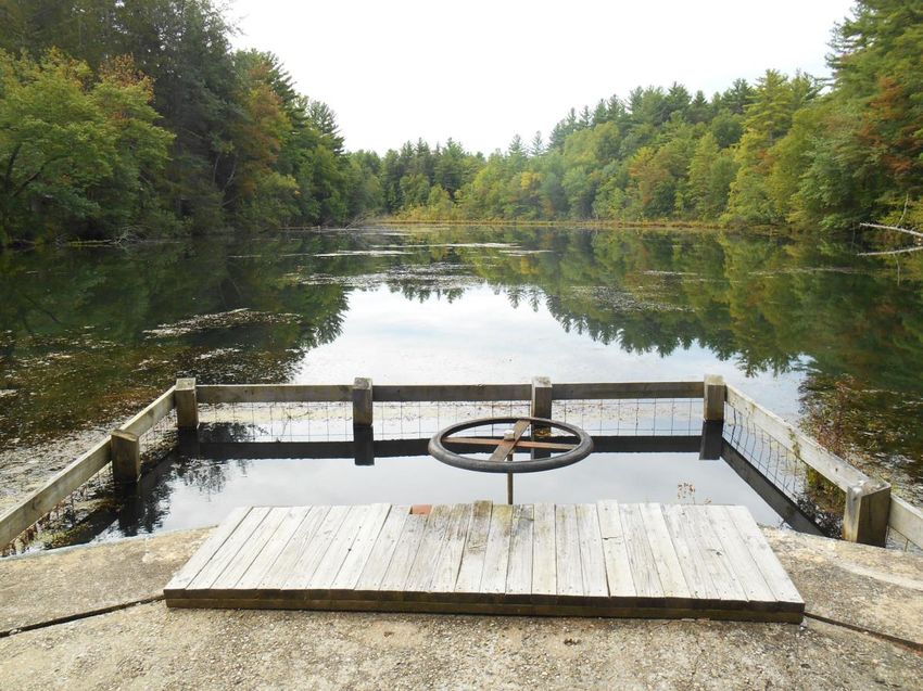
One of the many feeder streams to the Snook Kill in Wilton.
Loughberry Lake is a critical resource since it serves as the primary water supply and as a visual gateway
feature for the City of Saratoga Springs along the Route 50 corridor. Although approximately two-thirds
of Loughberry Lake is in the Town, Saratoga Springs owns the lands on the bottom of the lake as well as
the entire shoreline. The Town protects the lake by requiring a critical environmental review of any
development along the shoreline. It abides by the City of Saratoga Springs’s Watershed Rules and
Regulations, which do not permit recreational use of the lake or its shoreline. In the future, should the
City change these requirements, there may be an opportunity to utilize portions of the buffer area or a
part of the lake for swimming, fishing and other non-motorized recreational uses.
To protect the stream courses and waterways, the existing Town Zoning Code requires a buffer of non-
disturbance of various widths depending on grade and measured from the center of the stream course
or water body. This standard applies to the Snook Kill, Little Snook Kill, Delegan Brook, Bog Meadow
2-7Brook, and the tributaries leading to Lake Elizabeth and Loughberry Lake, as well as the water bodies
themselves.
Another water resource of ecological importance are vernal pools. A vernal pool is a confined basin with
no outlet stream where water stands on average for several weeks, usually in the spring and early
summer. During periods when water collects, these small, intermittent pools serve as breeding and
feeding sites for amphibians, such as salamanders and frogs. Vernal pools are difficult to identify during
their drier seasons of the year and are therefore difficult to protect. Because they may be visible only
during the spring months, they are often not taken into consideration during the review and permitting
process. However, the data relating to areas of terrain with 15 percent or greater slope reveals
“pockets” of steep slopes throughout Wilton, especially in the southeast quadrant of the Town (see
“Sensitive Environmental Areas Map”). The presence of these pockets may be indicators of potential
sites for vernal pools and may require further review during a subdivision or site plan review process.
Land use decisions that permit the laying of roads, tree cutting, and building construction in these areas
may have a significant adverse impact on the biological integrity of vernal pools.
Delegan Pond in Camp Saratoga.
2-82-9
Historic and Cultural Resources
The Town of Wilton was founded in 1818. The area where the Wilton-Gansevoort Road meets Ballard
Road and near the intersection of Parkhurst and Woodard Roads is the original settlement area of
Palmertown. It also forms the original hamlet of Wilton and still features many of the original buildings.
The Town features over one hundred buildings that are still intact and were homes to some of the
Town’s early founders, as well as its residents during the 19th century. According to “Saratoga County
Communities: An Historic Perspective,” the Town of Wilton was settled between the French and Indian
War and Revolutionary War when the area was known as Palmertown.

Prior to European settlers, Native Americans farmed the land and hunted in the vast forests, especially
in the western part of the Town, along the Palmertown Range. After the Revolutionary War, the families
of Stiles, King, Phillip, Laing, Perry, Dimmick, Johnson and McGregor moved into the area, and many of
their original homesteads are still intact. Also, many of the small hamlets in the Town still feature the
names of the founders, such as King’s Station, Stiles Corners, Dimmicks Corners, Emerson’s Corners, and
Mount McGregor.

From the original Native American settlements to
modern times, the Town of Wilton has developed
primarily around its travel corridors. The north-
south passageway from Saratoga Springs to Glens
Falls slowly began to develop and the Wilton
Hamlet featured many businesses such as the
Wilton hotel, stores, a blacksmith, wagon shop,
Wilton Academy, and several homes. The
completion of the Adirondack Northway had a
profound impact on the businesses along Route 9,
and today commercial growth is centered on the
two Northway exits within the Town, Exits 15 and
16. Although some of the buildings have been
identified and are still intact, many other
buildings and sites have been burned, torn down,
or are in disrepair. Future consideration of the                            Grant Cottage
                                                         State Historic Site: Final home of Ulysses S. Grant,
historic value of the remaining significant          Commanding General of the Union Army during the Civil War
buildings and sites as catalogued by the Town                 and 18th President of the United States.
Historian is recommended during development
review.

Wilton enacted Zoning Provision 129-173 Historic Preservation. This new law states that in cases where
the Town Historian has identified a building or site as a historically significant feature, the Town
Historian be given a 30-day notice for the opportunity to review and catalogue the site for inventory
purposes. This will ensure that historic sites and buildings are appropriately evaluated and
photographed before a building permit is granted, and, if plausible, the building be preserved in some
fashion, or portions of the building preserved for possible display by the Wilton Heritage Museum.
Consideration should be given to strengthening Wilton’s code to preserve the community’s historic
structures and places.

                                                  2-10
Agricultural Spaces
Historically, rural, open space was the dominant land use in the Town of Wilton. However, there are
now only a few active farming areas and land development has significantly impacted the extent of open
space in the town. Most of the active farms are scattered throughout the Town with some
concentration in the northeast corner of the Town.
The 2015 Inventory and Analysis performed by
the Town of Wilton determined that agricultural
lands and farms in the Town of Wilton totaled 220
acres, or 1 percent of the total Town acreage. This
represents a substantial change from 2007
statistics that reported 5% of the land as
agricultural. Currently, Saratoga PLAN, a land trust
operating in Saratoga County, is conducting a field
analysis to clarify the amount and types of active
agricultural uses in the Town of Wilton. Although
the results are incomplete, they provide some
insight on the existing stock of agricultural lands The Tooker Farm: 89 acres Protected by Purchase of
and farms. Development Rights through Saratoga PLAN
Saratoga PLAN has preliminarily identified 43 parcels totaling over 1,916 acres with agricultural lands or
farms in the Town. The average acreage per parcel is nearly 45 acres. Acreage calculations included the
entirety of the parcels considered despite the uses being contained to only a portion of each property.
Further site assessments are recommended to determine the scale of agricultural activities and verify
the formal nature of the use.
The agricultural uses and farms listed consist of poultry farms, horse farms and stables, hobby farms,
farm-raised meats, dairy farms, and field crop areas. These places represent an important component to
the economy of Saratoga County, offer scenic farm landscapes and provide a sense of place.
Due to the mixed rural and suburban character of the Town, it may be valuable for the Town and its
partners to divide existing agricultural activities between formal and informal uses. Formal uses include
commercial businesses activities which are considered part of the formal economy. Informal uses
involve properties whose primary uses are private residential or recreational but also include unofficial
agricultural activities considered part of the informal economy. For informal uses, the scale of
agricultural activities and infrastructure is a significant determinant in whether the property owner is
producing enough goods and services to be defined as a business enterprise.
Preserving all active farms in the Town of Wilton is a priority. Obtaining county, state, and federal
funding for preservation of farmland are among our goals. With so little active farming left in the Town,
and a growing number of mouths to feed and educate, the few remaining farms are a top priority.Unless
specific protections and alternative opportunities for landowners are presented, continued loss of
farmland, especially formal uses, is anticipated.
2.3 Growth and Development Patterns
The Town of Wilton continues to grow steadily. From its roots as a rural farming community in 1950
with a population of less than 1,500 people prior to the construction of the Adirondack Northway,
2-11Wilton has grown to its present status as a dynamic, suburban community with numerous business
operations and an estimated population of over 17,000. Recent population trends indicate that Wilton
will continue to attract new residents and businesses. The population more than doubled in the 30-year
period between 1980-2010 and is estimated to have increased by 650 people between 2010-2017
(3.8%) (See Table 1)
Table 1 Total Population – Town of Wilton & Saratoga County (1980-2017)
Town of Wilton Saratoga County
1980 1990 2000 2010 2020* 1980 1990 2000 2010 2020*
7,221 10,623 12,511 16,173 17,909 153,759 181,276 200,626 217,264 235,358
Source: U.S. Census Bureau
*CDRPC Projections
According to population statistics from the 2010 Census, the percentage of persons under 20 years old
(school-aged children) shifted slightly lower between 2000 and 2010. This change reflects a higher
percentage of residents who are 65 or older (see Tables 2 and 3).
Table 2 Population Percentage by Age – Town of Wilton & Saratoga County (2000-2017)
Town of Wilton Saratoga County
Under 20 20-35 35-65 Under 20 20-35 35-65
65+ Years 65+ Years
Years Years Years Years Years Years
2000 31.3% 16.6% 44.2% 7.9% 27.6% 19.1% 41.9% 11.5%
2010 27.0% 14.5% 46.2% 12.3% 25.8% 16.7% 44.4% 13.1%
2017 25.4% 16.8% 43.6% 14.3% 23.4% 17.7% 42.5% 16.5%
Source: U.S. Census Bureau
Table 3 Projected Population Percentage by Age – Town of Wilton & Saratoga County (2020-2050)
Town of Wilton Saratoga County
Under 25 25-44 45-64 Under 24 25-44 45-64
65+ Years 65+ Years
Years Years Years Years Years Years
2020 28.8% 23.1% 29.6% 18.4% 28.4% 23.9% 29.3% 18.5%
2030 27.2% 23.2% 25.5% 24.2% 27.1% 24.3% 25.2% 23.4%
2040 26.7% 22.5% 25.4% 25.3% 26.8% 24.0% 25.0% 24.2%
2050 26.0% 23.1% 27.0% 23.9% 27.0% 23.9% 26.6% 22.5%
Source: U.S. Dept. of Commerce, Bureau of the Census, & CDRPC Projections
One outgrowth of this population dynamic is an increased demand for recreation facilities to
accommodate active and passive forms of recreation for all age groups. Examples include opportunities
for on-road and off-road bicycling, trail hiking, additional playing fields and courts, and additional
playgrounds and unstructured open space.
According to the 2015 Town of Wilton Comprehensive Plan, the largest single active land use in the
Town is residential (more land identified as vacant or unused). The most intense area of residential
development lies between US Route 9 and the Northway south of Ballard Road with some recent
developments shifting the line of development northward a bit. This area consists of suburban style
development in subdivisions of varying sizes. Less intense residential development is scattered
throughout the remainder of the town. This development consists of small subdivisions and individual
lots.
2-12You can also read