2012Projects - 7th and 8th Call for Proposals - www.bmvit.gv.at - FFG
←
→
Page content transcription
If your browser does not render page correctly, please read the page content below
Austrian Space
                                                 Applications Programme

2012
Photo: Galileo satellites, Picture Credit: ESA
                                                   Projects - 7th and 8th Call for Proposals

                                                                                               > EDITION 1 > 2012 >

           www.bmvit.gv.at
Photo: CoReH2O, an Earth Explorer mission concept to observe snow and ice, Picture Credit: ESA

2 AUSTRIAN SPACE APPLICATIONS PROGRAMME
Foreword

Credit: Rigaud

Many innovations we use in our everyday lives are based on space       Space research is therefore also an important driving force
research – from navigation systems to weather forecasting.             for Austria’s economy. In Austria, some 1,000 scientists,
Austrian scientists make a major contribution to the development       researchers and engineers are involved in developing technical
of important space technology. The first two Austrian satellites       standards for satellites, launch vehicles, ground stations or
are soon to be sent into orbit. These mini satellites “made in         software programmes. Increasingly precise observations of our
Austria” will provide us with important data on the origin of the      planet enable earlier detection of impending natural disasters
universe.                                                              such as flooding.

The satellite project illustrates the important role of space          This brochure provides an overview of the projects currently being
exploration-related activities in Austrian research. I aim to ensure   undertaken as part of the Austrian Space Applications Programme
that Austria’s position in the space sector is further strengthened    ASAP. It serves not only to demonstrate the high economic
through targeted funding measures. Consistent participation in         relevance of the space research traditionally carried out here in
European Space Agency (ESA) programmes as well of course               Austria but also highlights Austria’s technological excellence in
as our own national space programme ASAP have secured                  this field.
Austria’s role as an international player in the field of space
research. Currently, around 100 Austrian companies are key
providers of cutting-edge technology on the international market.
With an annual turnover of 5.4 billion euros and around 32,000
employees, the European space industry is an important market
for Austrian technology.

                                                                                                Doris Bures
                                                                                        Federal Minister for Transport,
                                                                                         Innovation and Technology

                                                                                    AUSTRIAN SPACE APPLICATIONS PROGRAMME 3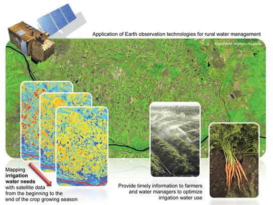
Content

Programme Description . . . . . . . . . . . . . . . . . . . . . . . . . . . .5                   DIACERAM . . . . . . . . . . . . . . . . . . . . . . . . . . . . . . . . . . . . . .45
Earth Observation . . . . . . . . . . . . . . . . . . . . . . . . . . . . . . . . .6             FRESSCO . . . . . . . . . . . . . . . . . . . . . . . . . . . . . . . . . . . . . . .46
ACAP . . . . . . . . . . . . . . . . . . . . . . . . . . . . . . . . . . . . . . . . . . . .7    FRPBonding . . . . . . . . . . . . . . . . . . . . . . . . . . . . . . . . . . . . . .47
AIM4X . . . . . . . . . . . . . . . . . . . . . . . . . . . . . . . . . . . . . . . . . . .8     ISS-SLEEP-KIT . . . . . . . . . . . . . . . . . . . . . . . . . . . . . . . . . . . .48
AQA-PM . . . . . . . . . . . . . . . . . . . . . . . . . . . . . . . . . . . . . . . . .9        NEMO . . . . . . . . . . . . . . . . . . . . . . . . . . . . . . . . . . . . . . . . . .49
compact-PTR-TOF-MS . . . . . . . . . . . . . . . . . . . . . . . . . . . . . .10                 Telecommunications . . . . . . . . . . . . . . . . . . . . . . . . . . . . . .50
CoReH20-Science . . . . . . . . . . . . . . . . . . . . . . . . . . . . . . . . .11              ASLE . . . . . . . . . . . . . . . . . . . . . . . . . . . . . . . . . . . . . . . . . . .51
E04Water . . . . . . . . . . . . . . . . . . . . . . . . . . . . . . . . . . . . . . .12         CDPP . . . . . . . . . . . . . . . . . . . . . . . . . . . . . . . . . . . . . . . . . . .52
FarmSupport . . . . . . . . . . . . . . . . . . . . . . . . . . . . . . . . . . . . .13          COSA . . . . . . . . . . . . . . . . . . . . . . . . . . . . . . . . . . . . . . . . . . .53
GMSM II . . . . . . . . . . . . . . . . . . . . . . . . . . . . . . . . . . . . . . . .14        GeMIE . . . . . . . . . . . . . . . . . . . . . . . . . . . . . . . . . . . . . . . . . .54
HighSens . . . . . . . . . . . . . . . . . . . . . . . . . . . . . . . . . . . . . . . .15       NextNav . . . . . . . . . . . . . . . . . . . . . . . . . . . . . . . . . . . . . . . . .55
LandSpotting . . . . . . . . . . . . . . . . . . . . . . . . . . . . . . . . . . . . .16         ONE-SAT-ILS . . . . . . . . . . . . . . . . . . . . . . . . . . . . . . . . . . . . .56
LISA . . . . . . . . . . . . . . . . . . . . . . . . . . . . . . . . . . . . . . . . . . . .17   QTS       . . . . . . . . . . . . . . . . . . . . . . . . . . . . . . . . . . . . . . . . . . .57
PRESENT . . . . . . . . . . . . . . . . . . . . . . . . . . . . . . . . . . . . . . . .18        SGIS . . . . . . . . . . . . . . . . . . . . . . . . . . . . . . . . . . . . . . . . . . .58
RAPIDEM . . . . . . . . . . . . . . . . . . . . . . . . . . . . . . . . . . . . . . .19          TCTM . . . . . . . . . . . . . . . . . . . . . . . . . . . . . . . . . . . . . . . . . . .59
Navigation . . . . . . . . . . . . . . . . . . . . . . . . . . . . . . . . . . . . . .20         TM/TC Modem . . . . . . . . . . . . . . . . . . . . . . . . . . . . . . . . . . .60
CrashPos . . . . . . . . . . . . . . . . . . . . . . . . . . . . . . . . . . . . . . . .21       Contacts . . . . . . . . . . . . . . . . . . . . . . . . . . . . . . . . . . . . . . . .61
FLIXDATE . . . . . . . . . . . . . . . . . . . . . . . . . . . . . . . . . . . . . . .22
GIOMO . . . . . . . . . . . . . . . . . . . . . . . . . . . . . . . . . . . . . . . . .23
I-Game NG . . . . . . . . . . . . . . . . . . . . . . . . . . . . . . . . . . . . . . .24
LOPT-GNSS . . . . . . . . . . . . . . . . . . . . . . . . . . . . . . . . . . . . . .25
NAVWAT 2 . . . . . . . . . . . . . . . . . . . . . . . . . . . . . . . . . . . . . . .26
PPP-Serve . . . . . . . . . . . . . . . . . . . . . . . . . . . . . . . . . . . . . . .27
PURSIT . . . . . . . . . . . . . . . . . . . . . . . . . . . . . . . . . . . . . . . . .28
RT-PPP . . . . . . . . . . . . . . . . . . . . . . . . . . . . . . . . . . . . . . . . . .29
SoftGNSStrusted . . . . . . . . . . . . . . . . . . . . . . . . . . . . . . . . . .30
Space Science . . . . . . . . . . . . . . . . . . . . . . . . . . . . . . . . . . .31
3D-POC . . . . . . . . . . . . . . . . . . . . . . . . . . . . . . . . . . . . . . . . .32
BRITE-Austria . . . . . . . . . . . . . . . . . . . . . . . . . . . . . . . . . . . .33
CDSM TRL-Uplift . . . . . . . . . . . . . . . . . . . . . . . . . . . . . . . . . .34
JUNO/Waves . . . . . . . . . . . . . . . . . . . . . . . . . . . . . . . . . . . . .35
MDS-MARS 500 . . . . . . . . . . . . . . . . . . . . . . . . . . . . . . . . . .36
METTRANS-ISS FP . . . . . . . . . . . . . . . . . . . . . . . . . . . . . . . .37
MMS-DFG 2 . . . . . . . . . . . . . . . . . . . . . . . . . . . . . . . . . . . . .38
TMIS.ascrea . . . . . . . . . . . . . . . . . . . . . . . . . . . . . . . . . . . . .39
Space Technology . . . . . . . . . . . . . . . . . . . . . . . . . . . . . . . .40
ACTRESS . . . . . . . . . . . . . . . . . . . . . . . . . . . . . . . . . . . . . . . .41
ADAM . . . . . . . . . . . . . . . . . . . . . . . . . . . . . . . . . . . . . . . . . .42
ASOT . . . . . . . . . . . . . . . . . . . . . . . . . . . . . . . . . . . . . . . . . . .43
BII-NACO . . . . . . . . . . . . . . . . . . . . . . . . . . . . . . . . . . . . . . . .44

4 AUSTRIAN SPACE APPLICATIONS PROGRAMME
Austrian Space Applications Programme

Programme Description

The Austrian Space Applications Programme ASAP was initiated            The programme elements “Scientific Excellence”, “Economic
by the Federal Ministry for Transport, Innovation and Technology        Benefits” and “Benefits for Society” are determined by the main
(bmvit) in 2002. It is a bottom-up research funding programme           objectives of the Austrian Space Applications Programme:
targeted at space science, technology and applications. The
programme is designed to enhance bilateral cooperation, support         > Development of scientific instruments for European and
scientific participation in ESA and bilateral projects and                international space missions
complement development in the application domain. It also aims          > Building new scientific skills within the scope of space
at promoting interesting technology niches in Austria. The                missions
Austrian Space Programme addresses Austrian and international           > Development of innovative technologies, products and
scientists, scientific institutions, industrial enterprises and other     processes
companies, including SMEs located in Austria.                           > Diffusion of space technologies in other sectors
                                                                        > Utilization of space technology for further applications like
ASAP supports Austrian research institutions as well as                   navigation, telecommunication, Earth observation and
commercial enterprises in their efforts to conduct space science          integrated applications
and exploration projects, and to develop space technologies,            > Making use of the potential of space based applications in
products and services.                                                    order to contribute solutions to the great challenges of our
                                                                          future

                                                                        Furthermore the Austrian Space Applications Programme ASAP
                                                                        aims at building national and international networks through
                                                                        multi- and bilateral projects and at expanding user communities
                                                                        of space technology.

                                                                                    AUSTRIAN SPACE APPLICATIONS PROGRAMME 5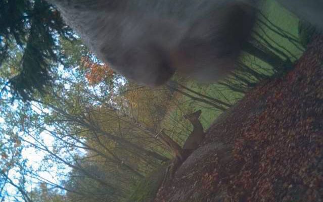
Earth Observation

                               ACAP

                               AIM4X

                               AQA-PM

                               compact-PTR-TOF-MS

                               CoReH2O-Science

                               EO4Water

                               FarmSupport

                               GMSM II

                               HighSens

                               LandSpotting

                               LISA

                               PRESENT

                               RAPIDEM

6 AUSTRIAN SPACE APPLICATIONS PROGRAMME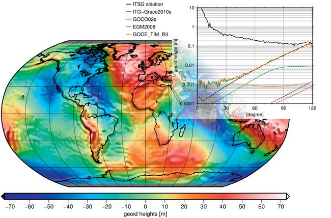
ACAP
Global Gravity Field Modelling From Orbit Data Based
on the Acceleration Approach

The main purpose of the ACAP project was to compute a global             Infobox
gravity field based on precise orbit information using the so-called
                                                                         Project duration:
acceleration approach. This method is based on Newton's second
law of gravitation, which states that the acceleration of a mass         01 April 2011 – 31 July 2012
is related to the forces acting on it. Transferred to a satellite this
means that all forces acting on it cause accelerations. These            Coordinator:
accelerations cannot be observed directly, but they can be               Graz University of Technology
calculated from orbit positions by means of numerical                    Institute of Theoretical Geodesy and Satellite Geodesy
differentiation. Beside some minor forces, like air drag, solar
                                                                         Torsten Mayer-Gürr
radiation pressure or gravity fields of the Moon, the Sun and
other planets, the main force in this context is the Earth's gravity     Steyrergasse 30, 8010 Graz, Austria
field.                                                                   T: +43 (0)316 873 – 6359
                                                                         mayer-guerr@tugraz.at
Different simulations were carried out to test the method and            www.itsg.tugraz.at
find the best configuration for estimating the gravity field.
Additionally different widely used numerical differentiators were
tested to find the most appropriate method to derive the
necessary accelerations. We tested Newton-Gregory inter-
polation, Taylor-MacLaurin differentiation and polynomial approxi-
mation. The investigations revealed that Newton-Gregory and
Taylor-MacLaurin are only a special case of a polynomial
approximation. Furthermore, using a polynomial provides far
more flexibility in terms of degree, used epochs and degree of
freedom. Based on these findings real data from ESA's GOCE
(Gravity field and steady-state Ocean Circulation Explorer)
mission was used to produce the gravity field solution shown in
the illustration below.

The investigations showed that the acceleration approach is
capable of producing competitive gravity field solutions,
compared to current high-end models based on satellite and/or
terrestrial data, especially in low degrees.
                                                                                                                                         The GOCE satellite in orbit.
                                                                                                                                          © ESA – AOES Medialab

                                                                                   Gravity field from 16 months of GOCE orbit data displayed as geoid heights
                                                                                   and the corresponding degree variances compared to state-of-the-art models.
                                                                                   © ITSG

                                                                                     AUSTRIAN SPACE APPLICATIONS PROGRAMME 7
AIM4X
Advanced INSAR Methods for TanDEM-X

The AIM4X project exploits the innovative capabilities of recent                                       Infobox
high-resolution SAR and radar altimeter missions. The German
                                                                                                       Project duration:
TanDEM-X and the Italian COSMO-SkyMed missions are for the
first time providing very high resolution SAR image data acquired                                      01 January 2011 – 30 June 2013
in an optimized configuration for generating elevation information
using SAR interferometry. Additionally, the Synthetic Aperture                                         Coordinator:
Interferometric Radar Altimeter (SIRAL) operating on board the                                         JOANNEUM RESEARCH Forschungsgesellschaft mbH
ESA Earth Explorer mission Cryosat-2 provides profiles of precise
                                                                                                       DIGITAL - Institute for Information and Communication
vertical measurements of the Earth’s surface enabling an
intercomparison and validation of surface elevation from different                                     Technologies (JR-DIG)
sources.The focus of the project was put on SAR-based                                                  Hannes Raggam
applications devoted to mapping and change detection in urban,                                         Steyrergasse 17, 8010 Graz, Austria
forest and glacier regions. The project objectives included:                                           T: +43 (0)316 876 – 1735
                                                                                                       DIGITAL-FER@joanneum.at
> Investigation of the interferometric mapping potential of high-
                                                                                                       www.joanneum.at
  resolution TanDEM-X and COSMO-SkyMed data for different
  environmental characteristics, like urban areas, forests or
  glacier regions                                                                                      Partner:
> Synergistic use of alternative processing methods, like stereo-                                      ENVEO Environmental Earth Observation IT GmbH
  radargrammetry and interferometry, and complementary                                                 Thomas Nagler
  image information in the mapping context, like backscatter,
                                                                                                       www.enveo.at
  coherence and phase information
> Retrieval methods of multi-temporal 2D and 3D information
  in urban, rural as well as glaciated environments
> Innovative change detection procedures based upon
  integrated use of 2D/3D approaches as well as their application
  and validation under various environmental conditions                                                The applicability and benefit of the change detection
> Generation and validation of surface elevation and deformation                                       developments for GMES services was demonstrated for
  products from TanDEM-X, TerraSAR-X and COSMO-SkyMed                                                  selected test cases, comprising change detection and mapping
  SAR data for glaciers                                                                                in urban, forest and glacier environments. Related scenarios
> Development and testing of synergistic tools for CryoSat-2                                           were specified in accordance with related GMES projects, like
  radar altimeter data and TanDEM-X SAR data for deriving                                              G-MOSAIC, GEOLAND or REDD/REDDAF, and the WCRP
  volume changes and mass balance of glaciers                                                          Climate and Cryosphere (CliC) Project.

TanDEM-X amplitude image (left), colour-coded interferogram (centre) and digital surface model (DSM)
generated therefrom (right). © JOANNEUM RESEARCH; input data provided by DLR
                                                                                                                 Surface displacement of Breiðamerkurjökull, Iceland, from COSMO-SkyMed data,
                                                                                                                  acquired on 22 and 30 November 2010, overlaid on amplitude image. © ENVEO

8 AUSTRIAN SPACE APPLICATIONS PROGRAMME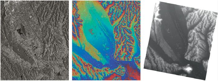
AQA-PM
Extension of the Air-Quality Model for Austria
With Satellite Based Particulate Matter Estimates

                                                                        Infobox
                                                                        Project duration:
                                                                        01 April 2011 – 31 March 2013

                                                                        Coordinator:
                                                                        Central Institute for Meteorology and Geodynamics
                                                  PM10 ground level
                                                                        (ZAMG)
                                                  distribution on a     Marcus Hirtl
                                                  European domain.      Hohe Warte 38, 1190 Vienna, Austria
                                                  © ZAMG                T: +43 (0)1 36026 – 2406
                                                                        marcus.hirtl@zamg.ac.at
Air quality is a key element for the well-being and quality of life     www.zamg.ac.at
of European citizens. It is regulated by EU legislation, which
requires monitoring and assessment of air pollution, informing
the public on air quality, predicting potential exceedance of           Partners:
specified quality levels, implementation of short-term action           SISTEMA GmbH
plans, and air quality management to attain specific limit and          Simone Mantovani
target values. The Air-Quality model for Austria (AQA) has been         www.sistema.at
operated by ZAMG (Central Institute for Meteorology and
Geodynamics) in cooperation with BOKU (University of Natural
Resources and Life Sciences) by order of the regional                   University of Natural Resources and Life Sciences
governments since 2005. AQA issues daily forecasts of gaseous           Institute of Meteorology
and particulate (PM10) air pollutants over Austria.                     Bernd C. Krüger
                                                                        www.boku.ac.at
Significant progress has been made towards the increased use
of satellite products related to air quality over the past few years.
                                                                        EOX IT Services GmbH
This progress has become possible due to advances in sensor
technology and new algorithmic approaches. The goal of this             Gerhard Triebnig
project was to improve the PM10 forecasts for Austria by                www.eox.at
integrating satellite based measurements and to provide a
comprehensive product platform.

The initial state of the atmosphere is not only essential for
meteorological forecasts but also for models that predict the
dispersion and chemical reactions of pollutants. For air quality
models the initial state is determined by the horizontal and
vertical distribution of different pollutants in the atmosphere.
Satellite measurements of aerosol optical thickness (AOT) can
be used in combination with ground based measurements of                                                       MODIS true colour image over
PM10 to provide highly-resolved initial fields. The combination                                                Austria. © SISTEMA
of previous model forecasts, ground based measurements and
satellite observations provides the best possible estimate of the
initial distribution of pollutants and is required for a good model
forecast. The advanced model system developed in the project
is expected to significantly improve the air quality forecasts for
Austria, which are currently based on ground observations only.
Potential applications of the advanced modelling system include                                                MODIS particulate matter PM2.5
daily air quality forecasts and environmental assessment studies                                               concentration map over Austria.
for historical episodes.                                                                                       © SISTEMA

                                                                                   AUSTRIAN SPACE APPLICATIONS PROGRAMME 9
compact-PTR-TOF-MS
Development of a Compact Time-of-Flight Mass Spectrometer for
Suborbital Research on the Earth's Atmospheric Composition

One of NASA’s strategic goals is to advance Earth systems
science to meet the challenges of climate and environmental
change. DISCOVER-AQ (Deriving Information on Surface
Conditions from Column and Vertically Resolved Observations
Relevant to Air Quality) is a multi-year NASA campaign aimed at
improving the use of satellites to monitor air quality
(http://discover-aq.larc.nasa.gov/). As part of DISCOVER-AQ,
NASA deploys two airborne science platforms for remote and
in-situ measurements of atmospheric pollutants over selected
                                                                   NASA's P-3B Airborne Science Laboratory. © NASA
areas in the US affected by poor air quality.

A research team of the University of Innsbruck was selected to
join the DISCOVER-AQ mission to carry out in-situ measurements
                                                                   Infobox
of atmospheric trace hydrocarbons on board NASA’s P-3B             Project duration:
Airborne Science Laboratory using the Proton-Transfer-Reaction     01 December 2011 – 30 November 2012
Mass Spectrometry (PTR-MS) technology developed in Austria.
PTR-MS data provide important information on air pollution         Coordinator:
sources and processes used to improve the interpretation of        University of Innsbruck
space-borne observations of air pollutants by current and future
                                                                   Institute for Ion Physics and Applied Physics
satellites.
                                                                   Armin Wisthaler
In this project supported by the Aeronautics and Space Agency      Technikerstraße 25, 6020 Innsbruck, Austria
of the Austrian Research Promotion Agency, a consortium            T: +43 (0)512 507 – 6241
composed of the University of Innsbruck and Ionicon Analytik       armin.wisthaler@uibk.ac.at
(Innsbruck) developed, constructed and validated a compact
                                                                   www.uibk.ac.at
PTR-TOF-MS instrument for deployment on NASA’s airborne
science platforms. The time-of-flight (TOF) capability enables
continuous measurements of atmospheric hydrocarbons with           Partner:
1-second time resolution, thus making a ground-breaking            Ionicon Analytik Gesellschaft m.b.H.
contribution to atmospheric composition research, increasing       www.ionicon.com
data coverage and improving time resolution by an order of
magnitude over previously deployed sensors. In addition, the
prototype provides a reduction in size and weight as compared
to existing instruments.

The new instrument is scheduled for deployment in NASA’s
upcoming DISCOVER-AQ missions and is anticipated to create
new commercial opportunities for Ionicon Analytik.

                                                                                                                     NASA DISCOVER-AQ mission
                                                                                                                     deployment strategy. © NASA

                                                                                                                     Armin Wisthaler (principal investigator)
PTR-TOF-MS instrument scheme. © Ionicon Analytik GmbH                                                                on board the NASA P-3B. © NASA

10 AUSTRIAN SPACE APPLICATIONS PROGRAMME
CoReH2O-Science
Scientific Preparation for the Snow Hydrology Mission CoReH2O
The project contributes to scientific preparations for the satellite Infobox
mission Cold Regions Hydrology High-Resolution Observatory Project duration:
(CoReH2O). CoReH2O is one of three candidate Earth Explorer
01 December 2010 – 31 May 2013
Core missions which were selected by ESA for detailed scientific
and technical feasibility studies (Phase A) in 2009. One of these
missions will be selected for implementation in 2013 and will Coordinator:
be launched in 2018. Earth Explorer missions focus on the ENVEO Environmental Earth Observation IT GmbH
science and research elements of ESA's Living Planet Helmut Rott, Thomas Nagler
Programme. CoReH2O will deliver detailed spatial data on key
Technikerstraße 21a, 6020 Innsbruck, Austria
parameters of the global snow and ice masses for applications
in climate research and hydrology. The proposed sensor is a dual T: +43 (0)512 50748 – 30
frequency, X- and Ku-band (9.6 and 17.2 GHz), dual-polarized helmut.rott@enveo.at, thomas.nagler@enveo.at
synthetic aperture radar (SAR). The primary parameters to be www.enveo.at
delivered by the mission include maps of snow extent, the mass
of snow (the snow water equivalent, SWE) on land surfaces and Partner:
snow accumulation on glaciers. The activities performed in this
EOX IT Services GmbH
project complement the Phase-A studies carried out within the
ESA Earth Explorer Programme. Gerhard Triebnig
www.eox.at
The project tasks included contributions to field campaigns on
radar measurements of snow, the analysis of these data, the Northern Finland (Sodankylä) at the test field of the Finnish
improvement of models for radar backscatter interactions with Meteorological Institute. The SnowScat instrument recorded
snow-covered terrain, and the testing and validation of radar backscatter throughout the winter at the same radar
procedures for extracting snow and ice parameters from radar frequencies as the CoReH2O sensor. The time series of snow
measurements. The figures show results of data analysis from mass (SWE) retrieved from these data provide the accuracy
field campaigns conducted in winter 2010/11 and 2011/12 in required for SWE products, as shown by the comparison with
in-situ snow measurements. First tests with a new Ku- and X-
band SAR sensor (SnowSAR) developed for ESA showed
promising results for deriving SWE maps from radar data.
The project was carried out in cooperation with associated
Snow cover test site with international partners:
SnowScat instrument, Arctic > Finnish Meteorological Institute, Helsinki
Research Centre of the Finnish > Interdisciplinary Centre on Climate Change, University of
Meteorological Institute, Waterloo, Canada
Sodankylä, February 2012. > Jet Propulsion Laboratory, California Institute of Technology,
© ENVEO Pasadena
SWE map derived from airborne
SnowSAR data, Sodankylä,
15 March 2011, superimposed on
Google Earth image. Colour scale:
SWE values in mm water Time series of snow mass (SWE) derived from SnowScat measurements, Sodankylä, winter 2010/11,
equivalent. © ENVEO and SWE measured in snow pits. © ENVEO
AUSTRIAN SPACE APPLICATIONS PROGRAMME 11EO4Water
Application of Earth Observation Technologies
for Rural Water Management
In most parts of the world, irrigated agriculture is the main user Infobox
of freshwater resources. Efficient water management is
Project duration:
therefore of essential importance, especially where water
scarcity is tangible and will be further stressed by growing 01 April 2012 – 31 March 2014
urbanization and decreasing annual precipitation. Current
irrigation management approaches based only on practical Coordinator:
experience and non-quantitative estimation tend to result in University of Natural Resources and Life Sciences
oversupply of water with consequent problems related to misuse
Institute of Surveying, Remote Sensing and Land
of water and mobilization of nitrates. More detailed knowledge
about the amount of water required by crops in different Information
development stages and climatic conditions is needed to achieve Francesco Vuolo
rational water use. Peter-Jordan-Straße 82, 1190 Vienna, Austria
T: +43 (0)1 47654 – 5135
The potentiality of Earth observation (EO) techniques in francesco.vuolo@boku.ac.at
supporting the management of water resources is being widely
www.eo4water.com
recognized. EO4Water aims at improving methodologies to
produce maps of crop water requirements at field and district
scale by combining information from EO satellites and ground Partners:
agro-meteorological data. EO4Water focuses on the Marchfeld Betriebsgesellschaft Marchfeldkanal
area, one of the major crop production areas of Austria with more Wolfgang Neudorfer
than 40,000 hectares of irrigated land, and includes field
www.marchfeldkanal.at
experiments to validate methodologies and adapt them to local
agricultural conditions. The project will offer innovative
management concepts and tools to complement current Adcon Telemetry GmbH
investments in irrigation infrastructures – such as the Bernhard Pacher
Marchfeldkanal Project. www.adcon.at
Economic Importance
Agriculture accounts for around 30 per cent of total water use
in Central Europe (up to 60 per cent in the Marchfeld area), and
the overall water demand for irrigation is increasing substantially
in Germany, France, Austria, and in Eastern European countries
such as Hungary, Bulgaria and Romania. The socio-economic
importance of irrigated agriculture is considerable. There is a
strong need and a potential demand for applications that support
efficient water management. Space technologies provide
tangible and substantial benefits. They help farmers and decision-
makers to use and manage water according to real crop water
requirements and thus to optimize production and cost-
effectiveness. EO4Water opens up possibilities for technology
transfer to other Central European regions and to the Danube
river-basin area, which is of great strategic importance for Europe.
© The satellite: GMES Satellite-2 (ESA); Maps: Landsat TM 5 images (NASA)
12 AUSTRIAN SPACE APPLICATIONS PROGRAMMEFarmSupport
Assessing the Potential of Farmer Mobile Information Services
for Agricultural Decision Support
FarmSupport aims at developing a proof-of-concept application Infobox
that will provide farmers in Ethiopia and Kenya with weather
Project duration:
forecasts and soil moisture information. This information service
is intended to help farmers in making agricultural decisions. 01 March 2012 – 31 August 2013
Weather information is of value to farmers, but has suffered in
the past due to problems with getting the information to the Coordinator:
farmer. International Institute for Applied Systems Analysis
(IIASA)
To tackle this issue, the application will be delivered via internet
and mobile phones, including iPhones. It will also be used to Steffen Fritz
collect crowd-sourced information from the farmers on crops Schlossplatz 1, 2361 Laxenburg, Austria
planted, crop yields and fertilizer use by means of a modified T: +43 (0)2236 807 – 353
Geo-Wiki, thereby promoting two-way communication flow fritz@iiasa.ac.at
between the data providers (IIASA & ZAMG) and the user (African www.iiasa.ac.at
farmer). The crowd-sourced data will be used to improve the
IIASA EPIC crop growth model. Improved crop models could
lead to more accurate early warning systems for food security Partner:
and to better estimates of current yield gaps. The crowd-sourced Central Institute for Meteorology and Geodynamics
data represents a potentially unique and valuable dataset for (ZAMG)
agricultural monitoring, mapping and modelling, and will be freely Alexander Jann
disseminated via Geo-Wiki. The project will test the information
www.zamg.ac.at
service in two locations: Ethiopia and Kenya.
The key data source underpinning the FarmSupport project is
soil moisture derived from the ASCAT sensor, which has become
available for Africa through the FFG-funded project Global
Monitoring of Soil Moisture for Water Hazards Assessment
(GMSM). FarmSupport adds value to GMSM by acting as an
additional application that will demonstrate the potential of
ASCAT-derived soil moisture. Farmers and the crop modelling
team at IIASA will be provided with soil moisture forecasts, which
will be obtained from the European Centre for Medium-Range
Weather Forecasts (ECMWF) and downscaled by ZAMG, and
ASCAT-derived soil moisture.
This project will provide an opportunity to compare these two
data sources and evaluate the usefulness of ECMWF soil
moisture forecasts as a source of information to farmers and for
crop modelling more generally. ZAMG will also compare soil
moisture derived from ASCAT with soil moisture from EPIC, and
historical forecasts of ECMWF soil moisture with historical soil
moisture from EPIC. This research component of the project will
address the accuracy of different soil moisture products and the
EPIC model.
Example: Geo-Wiki mobile app.
© IIASA
AUSTRIAN SPACE APPLICATIONS PROGRAMME 13GMSM II
Global Monitoring of Soil Moisture for Water Hazards Assessment
GMSM II was the follow-up of the GMSM activity performed Infobox
within ASAP 6. It was launched to advance the use of soil Project duration:
moisture services based on EUMETSAT’s MetOp ASCAT sensor
01 January 2011 – 31 July 2012
and complementary satellite systems. The GMSM II project has
successfully accomplished major achievements towards this
goal. Soil moisture is now seen to be one of the crucial Earth Coordinator:
observation data sets. Within the 8 GEO (Group on Earth Vienna University of Technology
Observations) Societal Benefit Areas (SBAs) of Agriculture, Department of Geodesy and Geoinformation
Climate, Disasters, Ecosystems, Energy, Health, Water, and
Wolfgang Wagner
Weather, soil moisture is one of only three of the twenty-five
highest ranked Earth observation parameters that is seen as a Gußhausstraße 27-29/120, 1040 Vienna, Austria
priority for all SBAs. T: +43 (0)1 58801 – 12225
ww@ipf.tuwien.ac.at
As the Near Real Time (NRT) ASCAT surface soil moisture (SSM) www.ipf.tuwien.ac.at
service heads towards its third year of operation, the SSM
product is declared as the second most downloaded product
Partners:
from EUMETSAT’s archive. Since the start of GMSM II, project
partners have been actively engaged in wining new projects Vienna University of Technology, Institute of Hydraulic
confirming that the scientific donor community (ESA, FFG) Engineering and Water Resources Management
critically regards the importance of the monitoring of surface soil Günter Blöschl
moisture. Notably Vienna University of Technology, in conjunction www.hydro.tuwien.ac.at
with other partners from GMSM II, have been selected to
spearhead a project within ESA’s Climate Change Initiative (CCI) Central Institute for Meteorology and Geodynamics (ZAMG)
establishing soil moisture as one of the 12 Essential Climate Alexander Jann
Variables (ECV) monitored from space borne systems. www.zamg.ac.at
In line with European Global Monitoring for Environment and University of Natural Resources and Life Sciences
Security (GMES) projects, GMSM II combines elements of a Core Institute of Meteorology
Service with a Downstream Service. The GMSM Core Service
Joseph Eitzinger
encompasses activities related to the further development and
validation of satellite soil moisture products. The GMSM www.wau.boku.ac.at/met.html
Downstream Service tackles the problem of how to translate University of Veterinary Medicine, Vienna, Biometeorology
the soil moisture information provided by the satellites into
and Mathematical Epidemiology Group
useful information for decision-makers and the public.
Franz Rubel
Seven application areas are covered by the GMSM project and www.vu-wien.ac.at/oeffentliches-veterinaerwesen
include the assimilation of soil moisture data in numerical weather
prediction, crop growth and yield, hydrological forecasting, AIT Austrian Institute of Technology GmbH
dynamic epidemic modelling, regional climate modelling, Klaus Steinnocher
relationships and trends of soil moisture, vegetation productivity www.ait.ac.at
and land cover and societal risk.
GeoVille Information Systems GmbH
Christian Hoffmann
www.geoville.com
University of Salzburg, Centre for Geoinformatics
Peter Zeil
www.zgis.at
Europe in drought? Soil moisture anomaly (5 year mean) for (left) January and (right) February 2012
shows Spain and Portugal are drier than usual. © Vienna University of Technology
14 AUSTRIAN SPACE APPLICATIONS PROGRAMMEHighSens
Highly Versatile, New Satellite Sensor Applications for the
Austrian Market and International Development
Infobox
Project duration:
01 December 2011 – 30 September 2012
Coordinator:
GeoVille Information Systems GmbH
Wolfgang Stemberger
Sparkassenplatz 2, 6020 Innsbruck, Austria
Prototype DSM generated with HighSens 3D Processing Suite. © JOANNEUM RESEARCH
T: +43 (0)512 562021
In an era of climate change and economic crisis, governments, stemberger@geoville.com
international organisations and industry alike make great efforts www.geoville.com
to improve efficiency by investing in state-of-the-art information
and communication technologies. The availability of agile Earth
Partner:
observation sensor data, such as from the Pléiades system,
meets a range of high level requirements. JOANNEUM RESEARCH Forschungsgesellschaft mbH
DIGITAL - Institute for Information and Communication
Current land cover mapping projects, the roll-out of LISA and a Technologies (JR-DIG)
permanent Austrian land monitoring capacity highly depend on Johannes Raggam
savings in image data acquisition and the consecutive availability
www.joanneum.at
of up-to-date, nationwide very high resolution (VHR) image data
coverage. The current technological level of aerial imagery in
combination with airborne laser scanning for land cover mapping
applications were raised to a stand-alone satellite-based
monitoring capacity.
Objectives of HighSens
HighSens, funded by the Austrian Research Promotion Agency
under ASAP 8 and supported by the governments of Salzburg
and Tyrol, responds to the user requirements for cost-effective
and readily available geo-information with the capacities of
Pléiades, resulting in an innovative Pléiades 3D Processing Suite.
The software enables the generation of digital surface and Aimed capacity results
elevation models (DSM/DEM/nDSM) from Pléiades tri-stereo of the HighSens
data, vastly improving horizontal accuracy. In combination with developments.
post-orthorectified multi-spectral tri-stereo imagery of the same © GeoVille
date, such accurate elevation data allows fully automated
analyses and provides a crucial new capacity for VHR land cover
monitoring worldwide. HighSens service applications were
demonstrated for disaster management (e.g. forestry storm
assessment) and rapid infrastructure assessments. Compared
to traditional, multi-source information gathering, the new single
source solution enables production of highly accurate geo-
information products at reduced time and cost, serving many
applications of public interest.
In summary, the objective of HighSens was to develop a software HighSens, generating
tool to generate highly accurate 3D information based on the innovative Pléiades
Pléiades system for the production of multi-parameter capacities to satisfy
information solutions needed in urban and forest mapping market requirements.
applications. © GeoVille
AUSTRIAN SPACE APPLICATIONS PROGRAMME 15LandSpotting
Collecting In-situ Data for Earth Observation
Product Validation via Social Games
At present there is no single satellite-derived global land cover Infobox
product that is accurate enough to provide reliable estimates of Project duration:
forest or cropland area. This project aimed to improve the quality
01 February 2011 – 31 October 2012
of land cover information by vastly increasing the amount of in-
situ data available for calibration and validation of satellite-derived
land cover. Land cover is an Essential Climate Variable (ECV), Coordinator:
which is required to support the work of the United Nations International Institute for Applied Systems Analysis (IIASA)
Framework Convention on Climate Change (UNFCCC) and the Steffen Fritz
Intergovernmental Panel on Climate Change (IPCC). All ECVs
Schlossplatz 1, 2361 Laxenburg, Austria
are technically and economically feasible for systematic
observation. These climate variables require international T: +43 (0)2236 807 – 353
exchange for both current and historical observations. fritz@iiasa.ac.at
www.iiasa.ac.at
The Geo-Wiki system currently allows users to compare three
satellite-derived land cover products and validate them using Partners:
Google Earth. However, there is presently no incentive for anyone
FOTEC Forschungs- und Technologietransfer GmbH
to provide this data so the amount of validation through Geo-
Wiki has been quite limited so far. The LandSpotting project Martina Dürauer
takes a truly innovative approach by adding crowdsourcing www.fotec.at
through the development of games. The games engage users
whilst simultaneously collecting a large amount of in-situ land EOX IT Services GmbH
cover information. The development of the games was informed Gerhard Triebnig
by the current raft of successful social gaming. www.eox.at
At the same time, the Geo-Wiki system was modified to exploit Vienna University of Technology
the latest available satellite images and to use the in-situ validation Institute of Computer Graphics and Algorithms
data, which is also collected via competition.geo-wiki.org, to Michael Wimmer
create new outputs: www.tuwien.ac.at
> A hybrid land cover map, which takes the best information from
each individual product to create a single integrated version
> A database of validation points that will be freely available to
the land cover user community
> A facility that allows users to create a specific targeted
validation area, which will then be provided to the
crowdsourcing community for validation
These outputs will turn Geo-Wiki into a valuable system for
many land cover users.
Geo-Wiki validation points: Volunteers from around the globe can classify Google Earth imagery, LandSpotting games.
and input their agreement/disagreement with the existing data. © IIASA © IIASA
16 AUSTRIAN SPACE APPLICATIONS PROGRAMMELISA
Land Information System Austria
Land cover and land use maps (left to right: orthophoto 2009 – land cover map – land use map). Change detection (left to right: orthophoto 1999 – orthophoto 2008 – recognized changes).
© JOANNEUM RESEARCH, State of Carinthia © GeoVille, State of Tyrol
Austria can build on a long experience in land cover and land use Infobox
(LC/LU) monitoring. However, these datasets have been Project duration:
produced with different standards, lack comparability or are
01 May 2009 – 29 June 2012
outdated in most cases.
The development of the Land Information System Austria (LISA) Coordinator:
was initiated within ASAP 6 and continued within ASAP 7 to GeoVille Information Systems GmbH
overcome the shortcomings of the existing LC/LU datasets for Andreas Walli
regional, national as well as European management and reporting
Sparkassenplatz 2, 6020 Innsbruck, Austria
requirements. The development was implemented as a three-
stage process: concept phase (2009 – 2010), completion phase T: +43 (0)512 562021 – 0
(2010 – 2012) and roll-out phase (from 2012). walli@geoville.com
www.geoville.com
The concept phase achieved a consensus among the
stakeholders, users and the scientific/technical community about Partners:
the specifications for the new Austrian LC/LU data model and
AIT Austrian Institute of Technology GmbH
land monitoring system. In an iterative process, a technically
feasible requirements catalogue and data model were Klaus Steinnocher
established, processing chains developed, prototypes produced www.ait.ac.at
and verified, and the costs determined. The concept phase
provided demonstration prototypes covering a total of 49 diverse JOANNEUM RESEARCH Forschungsgesellschaft mbH
test sites (> 3,000 km²), a user-defined, technically feasible and DIGITAL - Institute for Information and Communication
scientifically verified requirements catalogue as well as an Technologies (JR-DIG)
architecture and data model for implementation. Mathias Schardt
www.joanneum.at
The completion phase developed critical components enabling
the operational roll-out of LISA as a national and operational Graz University of Technology
monitoring solution. These included establishment of the data Institute of Remote Sensing and Photogrammetry
model in a physical database, the implementation of a fully
Rainer Prüller
automated change detection and upscaling method (spatial
aggregation to European level) and the demonstration of LISA www.geoimaging.tugraz.at
for the usage in spatial planning applications. University of Natural Resources and Life Sciences
Institute of Surveying, Remote Sensing and Land
The roll-out phase has already been initiated through single
initiatives of regional governments which financed land Information
cover/land use data production according to LISA specifications Reinfried Mansberger
for part of their territory. This represented a major achievement www.boku.ac.at
in making LISA a sustainable user accepted standard.
Nevertheless, the ultimate vision is to initiate single funded, Umweltbundesamt - Environment Agency Austria
country-wide roll-out to fulfil the initial user requirements for a Gebhard Banko
homogenous and operational land monitoring system for Austria. www.umweltbundesamt.at
AUSTRIAN SPACE APPLICATIONS PROGRAMME 17PRESENT
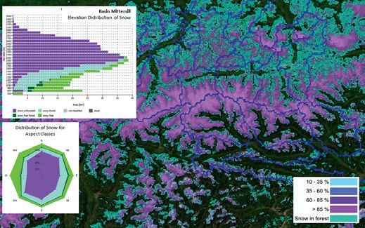
Preparing for the ESA Sentinel Missions
Forest monitoring application
including change detection (top) and
Infobox
classification of canopy closure
Project duration:
(bottom) using Spot image data 01 April 2012 – 31 March 2014
acquired in 1987 and 2003.
© JOANNEUM RESEARCH Coordinator:
JOANNEUM RESEARCH Forschungsgesellschaft mbH
DIGITAL - Institute for Information and Communication
Technologies (JR-DIG)
Mathias Schardt
Steyrergasse 17, 8010 Graz, Austria
T: +43 (0)316 876 – 1735
DIGITAL-FER@joanneum.at
www.joanneum.at
Partner:
The Sentinel satellite family is the flagship of Earth observation ENVEO Environmental Earth Observation IT GmbH
satellites operated by ESA and EC and provides the continuity Thomas Nagler
for operational monitoring of the environment and climate using www.enveo.at
optical and microwave satellite data for the next decades. Various
types of ground segments are implemented to provide
information from Sentinel satellites for public use. Acquisition,
processing, archiving and validation of the large amount of Sentinel
data is organized in Core Ground Segments implemented by ESA.
They are supported by Mission Performance Centres, providing
calibration, validation, quality control, or end-to-end system
performance assessments. These segments are complemented
by Collaborative Ground Segments, installed at national and
regional level in order to provide higher level products and services
based on Sentinel data sets.
The project is aimed at developing technical concepts in preparation
for a potential involvement into the above opportunities. The
technical developments of the project thus refer to:
> Evolution of data processing algorithms
> Development of quality assessment procedures for Sentinel Fractional snow map covering the Alps, 27 February 2012, from medium resolution multi-spectral
core products optical data and statistical snow information for the Mittersill Basin. © ENVEO
> Development of advanced methods for the derivation and
monitoring of alpine land use and land cover maps for alpine
regions previous national projects like ASAG or Triple-M. Dedicated
> Development of innovative algorithms to generate snow and concepts with respect to the establishment of a Quality
glacier products from multi-sensor Sentinel data, and methods Assessment Expert Laboratory or a Collaborative Ground
for data assimilation and product validation Segment are further elaborated.
> Demonstration applications to generate land use, change detection,
snow and glacier products using simulated Sentinel data sets Apart from the opportunities mentioned above, the project
developments will be of benefit for ongoing GMES-related
Simulations of optical as well as SAR (Synthetic Aperture Radar) activities of the project partners, such as GEOLAND-II, EUFODOS
Sentinel image data kindly provided by ESA are used for the and CryoLand, as well as for future national and international
developments and investigations in the project, which builds on research contracts.
18 AUSTRIAN SPACE APPLICATIONS PROGRAMMERAPIDEM
Rapid Assessment Provision for Intelligent Disaster
and Emergency Management
Infobox
Project duration:
01 January 2012 – 31 December 2012
Coordinator:
JOANNEUM RESEARCH Forschungsgesellschaft mbH
DIGITAL - Institute for Information and Communication
Technologies (JR-DIG)
RAPIDEM prototype results of near real-time TerraSAR-X based water body detection.
Hannes Raggam
© GeoVille
Steyrergasse 17, 8010 Graz, Austria
The numerous large- and small-scale natural disasters that have T: +43 (0)316 876 – 1735
occurred in Austria, Europe and worldwide in the past have DIGITAL-FER@joanneum.at
prompted disaster relief organisations to improve their crisis
www.joanneum.at
management capabilities by using innovative communication and
information technologies. Valuable image information for instance
can be gathered on-demand from satellite and airborne remote Partners:
sensing systems. Along with existing geo-databases, spatial GeoVille Information Systems GmbH
information of the situation on the ground can be rapidly and Andreas Walli
objectively provided to disaster management organisations.
www.geoville.at
This project aimed at the development of information products
and service structures supporting critical decision-making
processes in flood disaster management for the Austrian disaster Vienna University of Technology
relief organisations. Time-critical data and information generation Department of Geodesy and Geoinformation
are a major factor in successful disaster management. Markus Hollaus
www.ipf.tuwien.ac.at
The project integrates both the existing satellite TerraSAR-X near
real-time service and an airborne multi-sensor data acquisition
platform developed by JOANNEUM RESEARCH, which may
include optical, thermal or infrared cameras, in order to ensure
rapid data availability and an efficient support of decision
processes in different emergency situations. New information Top: airborne data acquisition.
products based on a combination of these different data sources Bottom (left): optical image with marked
and an optimized ordering, processing and management system flooded area.
are designed to provide Austrian decision-makers with a Bottom (right): thermal data showing critical
comprehensive and seamless service for emergency water dam wetness.
management. © JOANNEUM RESEARCH
A strong focus on interoperability and modularity ensures that
these developments can be rapidly expanded and integrated into
existing systems. The services developed are coordinated with
the Austrian National Crisis and Disaster Protection Management
(SKKM 2020) strategy and are tailored to the requirements of
the User Executive Board of the project, which includes
representatives from the regional governments of Styria and
Lower Austria as well as additional experts in the field of
emergency and crisis management.
AUSTRIAN SPACE APPLICATIONS PROGRAMME 19Navigation
CrashPos
FLIXDATE
GIOMO
I-Game NG
LOPT-GNSS
NAVWAT 2
PPP-Serve
PURSIT
RT-PPP
SoftGNSStrusted
20 AUSTRIAN SPACE APPLICATIONS PROGRAMMECrashPos
Single-frequency RTK for an Advanced Driver
Assistance System Test Bed
Road traffic injuries are the leading cause of death among young
people. People referred to as “vulnerable road users” such as
pedestrians or cyclists are especially at risk. As a result, one of
the major tasks within automotive industry is to enhance
Advanced Driver Assistance Systems (ADAS) which support the
driver in critical situations. Examples of ADAS are pedestrian
detection systems or emergency brake assistants.
The increasing importance of ADAS in the car industry also
requires the development of control modules designed to
facilitate the test process of these systems with a special focus
on realistic tests. Such a test system usually consists of a test
vehicle, one or more dummy platforms and a control server. One
very important part of the test system is the accurate positioning
and guidance of the vehicles involved, which is generally solved
with Global Navigation Satellite Systems (GNSS).
CrashPos system design. © Institute of Navigation, Graz University of Technology
Currently available test systems are based on high-cost
positioning equipment. The scope of this project is to use
reasonably priced positioning components as well as a unique
dummy platform called UFO (Ultraflat Overrunnable Obstacle),
which was developed by Dr. Steffan – Datentechnik Gesellschaft
m.b.H.. The UFO platform can be used to simulate accident
Infobox
scenarios, e.g. with pedestrians. It is also flat enough to be Project duration:
overrun by a standard car, thus preventing vehicle damage. To 01 March 2012 – 31 August 2013
meet the price and size restrictions, a single-frequency Real Time
Kinematics (RTK) solution, a relative GNSS technique, will be Coordinator:
calculated on board the test vehicle and the dummy platform(s).
Graz University of Technology
The vehicle motions are highly kinematic – up to 80 km/h are Institute of Navigation
expected. Special challenges of the project include mounting Roman Lesjak
the flat antenna on the UFO, satellite shadowing and multipath Steyrergasse 30, 8010 Graz, Austria
as well as meeting the accuracy requirements with low-cost T: +43 (0)316 873 – 6832
equipment. The relative RTK solution will thus be integrated with roman.lesjak@tugraz.at
inertial measurements, which are essential to increase the
www.inas.tugraz.at
update rate and improve the position solution received from
relative GNSS measurements. The final trajectory positions will
be sent to a control server to enable supervising the test of the Partners:
specific ADAS module in real time. Alpen-Adria-Universität Klagenfurt
Institute for Smart-Systems Technologies
Vamsi Prakash Makkapati
www.uni-klu.ac.at/tewi/ict/sst
Dr. Steffan – Datentechnik Gesellschaft m.b.H.
Andreas Moser
www.dsd.at
UFO with dummy.
© Dr. Steffan – Datentechnik Gesellschaft m.b.H.
AUSTRIAN SPACE APPLICATIONS PROGRAMME 21FLIXDATE
Floating Ski Data by GNSS
The FLIXDATE project intends to develop a demonstration
system for alpine ski sport traffic analysis, traffic routing and
collision avoidance on ski slopes. Detection of dangerous zones
and management of ski traffic based on floating ski data lead to
increased safety and traffic performance on ski slopes.
Given the dramatic increase in ski lift capacities in recent years,
the topic of skiing safety is of growing importance. Modern chair
lifts are able to carry several thousands of people per hour
resulting in a dramatically increased density of people on the
slopes. Skiers are also travelling at high and often uncontrolled
speeds due to huge improvements in material and ski design,
which has led to a sharp rise in the number of accidents, including
many fatalities. The motivation of this project is therefore to
reduce alpine skiing accidents significantly and to enhance Schematic representation of the FLIXDATE system architecture. © FLIXDATE consortium
comfort on slopes.
The collection of floating ski data is based on GNSS as a Infobox
positioning source and smart phones for data acquisition and Project duration:
transmission. For this purpose the skiing resort provides the
01 January 2012 – 30 June 2013
rental of preinstalled outdoor phones and the download of an
application (app) onto private phones. In a later development
stage additional features are added to attract users, for example Coordinator:
a map of the skiing resort, evaluation of the personal skiing day TeleConsult Austria GmbH
and outdoor games. Philipp Berglez
Rettenbacher Straße 22, 8044 Graz, Austria
The collected data is sent via WLAN hot spots to a central server
T: +43 (0)316 890971 – 14
where the data is stored in a database. For optimum position
performance EDAS (EGNOS Data Access System) data are pberglez@tca.at
obtained via PANDAS (Positioning and Navigation Data Assistance www.tca.at
Service) to augment the position solution and to obtain more
accurate position and speed information. Once Galileo will be Partners:
available, the system will benefit from the increased number of
GeoMatica – Dipl.-Ing. Johannes Vallant
visible satellites since slopes are often north facing.
Johannes Vallant
Data evaluations are used to mark geo-referenced areas within www.geomatica.at
the skiing resort classified as high risk and to generate near real-
time traffic information. This information can be used to secure EDS EnergyData Software OG
dangerous zones and to guide skiers to non-crowded areas using Günther Abwerzger
information screens and electronic traffic signs, thus managing
www.energydata.at
skier traffic throughout the skiing area.
Schematic representation of the
Impression of test data acquisition. floating ski data algorithm.
© Johannes Vallant © EDS EnergyData Software OG
22 AUSTRIAN SPACE APPLICATIONS PROGRAMMEGIOMO
Next Generation Near Real-time Ionospheric Models
The objectives of the GIOMO (next Generation near real-time Infobox
IOnospheric MOdels) project were the identification and Project duration:
consolidation of improved ionospheric modelling technologies,
01 January 2011 – 31 May 2012
the software implementation of a selected refined model, and
the final integration into the existing OEGNOS (Austrian EGNOS
data server) software in order to improve the positioning accuracy Coordinator:
for this augmentation service and thus to foster user acceptance. TeleConsult Austria GmbH
The project therefore started with a state-of-the-art analysis Albert Kemetinger
including a general description of the physical effects and the
Rettenbacher Straße 22, 8044 Graz, Austria
structure of the ionosphere between the GNSS satellites and
the Earth’s surface with a focus on the TEC (Total Electron T: +43 (0)316 890971 – 10
Content) as major observable, and an analysis of different existing akemetinger@tca.at
observation methods and networks. Based on these analyses, www.tca.at
a survey and comparison of existing models were carried out,
including possible refinement approaches. This led to the Partners:
selection of the candidate model to be implemented, including
Vienna University of Technology
refinement as pseudo-code and ionospheric model software
module. The near real-time model OLG RIM (Observatory Institute of Geodesy and Geophysics
Lustbühel Graz Regional Ionospheric Map) was chosen from code Robert Weber
measurements based on investigations in terms of statistics, www.hg.tuwien.ac.at
stability, temporal and regional flexibility as well as availability.
Austrian Academy of Sciences
Subsequently, the software module was integrated into the
OEGNOS software, replacing the standard model currently used, Space Research Institute (IWF)
in order to improve service accuracy. NeQuick was implemented Walter Hausleitner
as a backup model. www.iwf.oeaw.ac.at
The OEGNOS software is an EGNOS-based augmentation
service providing “improved” EGNOS correction to users via a
terrestrial communication link. To enable the service for GIOMO: next Generation near
commercial off-the-shelf receivers without modifications, the real-time IOnospheric MOdels.
standardized Ntrip protocol was chosen for communication © TeleConsult Austria
between OEGNOS server and receiver.
Finally, static and kinematic tests were carried out using a test
user terminal in order to analyse the accuracy gain achieved by
the refined ionospheric model.
Flowchart of the near real-time process. © IWF
System architecture of the GIOMO project. © TeleConsult Austria
AUSTRIAN SPACE APPLICATIONS PROGRAMME 23I-Game NG
Integrated Telemetry and GIS-System for Wildlife Management Next Generation
Wildlife monitoring provides valuable information for a wide Infobox
range of socio-political, ecological and economic issues. Major 01 November 2011 – 30 April 2013
application areas include reduction of wildlife accidents, planning
of large infrastructure projects, reduction of forest damage, and
wildlife biology research. Coordinator:
JOANNEUM RESEARCH Forschungsgesellschaft mbH
Current wildlife telemetry systems using collar transmitters have DIGITAL - Institute for Information and Communication
the disadvantage of disturbing the animals’ behaviour and of Technologies (JR-DIG)
being costly in terms of required resources. Newly developed
Heinz Mayer
systems based on GPS and GSM technology still have a relatively
low data rate due to a restricted energy supply. The project is Steyrergasse 17, 8010 Graz, Austria
thus aimed at developing a telemetry system based on GPS and T: +43 (0)316 876 – 1721
GSM technology which provides generally higher data rates due heinz.mayer@joanneum.at
to additional energy generation on the animal. A camera mounted www.joanneum.at/en/digital/mva.html
on the telemetry collar provides additional significant information
on the animal’s behaviour. In order to identify the location,
Partners:
residence time and movement patterns of animals and precisely
analyse their habitat requirements, all essential spatial WWN Wildökologische Waldwirtschaftliche Naturräumliche
information (existing maps, results from satellite and aerial photo Planung & Beratung
interpretation, GPS points, digital elevation model etc.) is Martin Forstner
integrated into a Geographical Information System (GIS). This www.wwn-forstner.at
enables automatic calculation of statistics on habitat use and
visualization of integrated information.
Prototypenbau Meister
A major project outcome will be a concept for small series Norbert Meister
production of the telemetry collar for wildlife monitoring as well
as one enhanced test collar based on satellite navigation (GPS, Graz University of Technology
Galileo), telecommunication and data transmission modules Institute of Remote Sensing and Photogrammetry
(GSM, WLAN, satellite), a camera and various sensor devices.
Mathias Schardt
www.geoimaging.tugraz.at
Telemetry collar immediately before evaluation. © I-Game NG On game habitat capture. © I-Game NG
24 AUSTRIAN SPACE APPLICATIONS PROGRAMMEYou can also read